Laboratorio di Geomatica Como Campus PoliCrowd A Social World Wind Platform
|
|
|
- Evangeline Blake
- 8 years ago
- Views:
Transcription


1 Laboratorio di Geomatica Como Campus PoliCrowd A Social World Wind Platform Maria Antonia Brovelli, Marco Minghini and Giorgio Zamboni

2 PoliCrowd PoliCrowd is a Web-based 3D Participatory GIS application born to promote the world's tourism and cultural heritage interaction with user mobile devices for uploading Points Of interest (POIs) POIs three-dimensional visualization on World Wind virtual globe user collaborative contribution in POIs characterization creating, saving and sharing customized maps with the community 2

3 NASA World Wind Challenge and via Regina Project Initially developed in a project presented at the NASA WordWind Europa Challenge (Florence, INSPIRE Conference 2013), it will be applied in next months in I cammini della Regina ( The paths of Regina ) INTERREG Project, where Via Regina is one of the oldest paths for historical and cultural exchanges between Italy and Switzerland. V ia R e g in a 3

4 Participatory GIS - an Open Source architecture SERVER CLIENT 2D WMS template form AGGREGATE compiled form COLLECT 4

5 Execution of the field-survey Application main menu: COLLECT 5

6 Execution of the field-survey Guided form compilation: COLLECT 6

7 Execution of the field-survey Guided form compilation: COLLECT 7

8 Execution of the field-survey Guided form compilation: COLLECT 8

9 Execution of the field-survey Guided form compilation: COLLECT 9

10 Execution of the field-survey Guided form compilation: COLLECT 10

11 Execution of the field-survey Guided form compilation: COLLECT 11

12 Execution of the field-survey Guided form compilation: COLLECT 12

13 2D data visualization - computer 13

14 2D data visualization - computer 14

15 2D data visualization - tablet 15

16 2D data visualization - smartphone 16

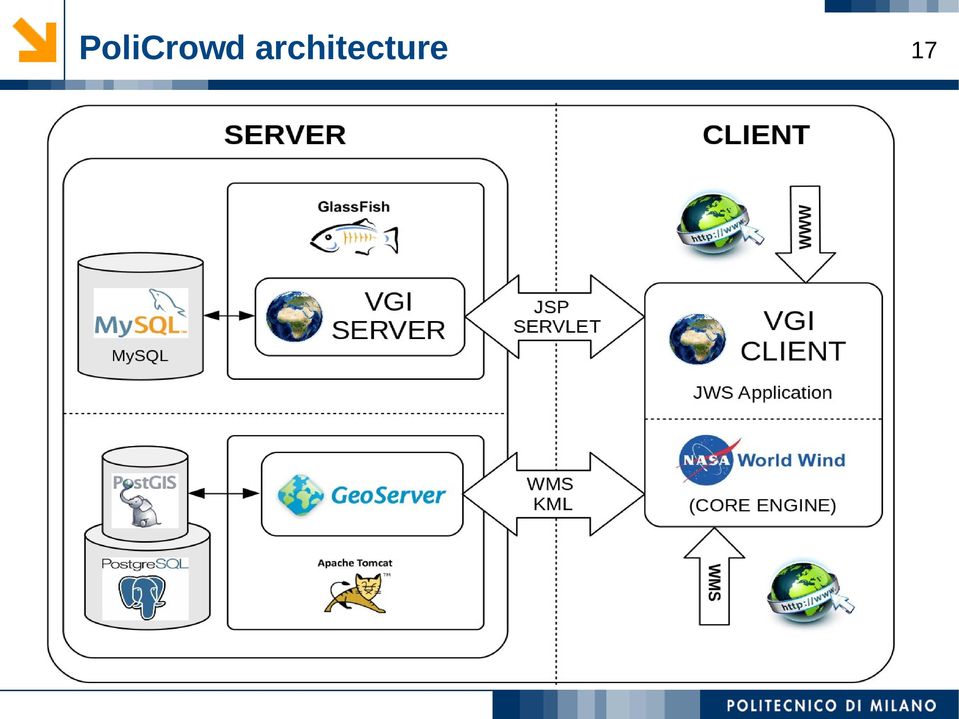
17 PoliCrowd architecture 17
18 3D data visualization Points Of Interest 3D visualization at the first Level Of Detail altitude of the point of view over the globe higher than 3000 meters representation of all the POIs with a common icon (i.e. a pin) dragging on POIs is not allowed 18

19 3D data visualization 19 Points Of Interest 3D visualization at the second Level Of Detail altitude of the point of view over the globe between 3000 and 1000 meters representation of POIs with icons showing the category they belong to points with panoramic view monuments historical/monumental buildings places of worship places of artistic/cultural activities sports facilities transport stations events dragging on POIs is allowed only for POIs owners

20 3D data visualization 20 Points Of Interest 3D visualization at the third Level Of Detail altitude of the point of view over the globe less than 1000 meters representation of POIs with icons showing their classification: a POI belonging to the monuments category can e.g. be classified as statue/sculpture fountain historical monument dragging on POIs is allowed only for POIs owners

21 3D data visualization 21 Querying Points Of Interest clickable POIs placemarks visualization of Android ODK Collect-reported information (including picture) in a balloon which extends the DialogAnnotation class
22 User interaction with POIs Upload page for registered users DICA - Laboratorio di Geomatica, Polo Territoriale di Como 22
23 User interaction with POIs Viewing the image list relative to a POI DICA - Laboratorio di Geomatica, Polo Territoriale di Como 23
24 Projects catalogue Creation and Visualization of user projects 24
25 Adding layers to the project Adding layers from the layer catalogue 25
26 Contacts 26 Politecnico di Milano Laboratorio di Geomatica - Polo Territoriale di Como Via Valleggio 11, Como (Italy) DICA - Laboratorio di Geomatica, Polo Territoriale di Como
Web Mapping technologies for the valorization of slow tourism: the Via Regina project
 Web Mapping technologies for the valorization of slow tourism: the Via Regina project Maria Antonia Brovelli, Candan Eylul Kilsedar, Marco Minghini, Giorgio Zamboni Politecnico di Milano (DICA) Laboratorio
Web-based Participatory GIS with data collection on the field: a prototype architecture in two and three dimensions
 8 Convegno Nazionale del Gruppo di Geologia Informatica Sezione della Società Geologica Italiana Chiavenna (SO), 17-19 giugno 2013 Ex Convento dei Cappuccini, Via Molinanca DICA Laboratorio di Geomatica
The paths of Via Regina geomatics for sustainable mobility
 FOSS4G Europe Bremen 15-17 July 2014 The paths of Via Regina geomatics for sustainable mobility Maria Antonia Brovelli (*), Massimiliano Cannata (**), Alba Lucchese (*), Marco Minghini (*), Marco Negretti
Web publication and sharing of historical and cultural knowledge: the Via Regina project
 9 Convegno Nazionale del Gruppo di Geologia Informatica Sezione della Società Geologica Italiana Montefalco (PG), 16-18 giugno 2014 Complesso Museale di San Francesco Web publication and sharing of historical
Promoting slow tourism through FOSS4G Web Mapping: an Italian-Swiss case study
 Promoting slow tourism through FOSS4G Web Mapping: an Italian-Swiss case study Milan Antonovic1, Maria Antonia Brovelli2, Massimiliano Cannata1, Mirko Cardoso1, Candan Eylül Kilsedar2, Marco Minghini2,
I Cammini della Regina
 I Cammini della Regina Percorsi transfrontalieri legati alla Via Regina Maria Antonia Brovelli, Alba Lucchese, Marco Minghini, Marco Negretti, Giorgio Zamboni Laboratorio di Geomatica del Politecnico di
Green Move Web Viewer: critical issues and implementation
 GIT Geology and Information Technology 8a Riunione del Gruppo di Geologia informatica Sezione della Società Geologica Italiana Chiavenna, 17-19 giugno 2013 Polo Territoriale di Como Laboratorio di Geomatica
Web Mapping technologies for the valorization of slow tourism: the Via Regina project
 Web Mapping technologies for the valorization of slow tourism: the Via Regina project Maria Antonia Brovelli maria.brovelli@polimi.it Candan Eylül Kilsedar candaneylul.kilsedar@polimi.it Marco Minghini
Enterprise Optimization
 Enterprise Optimization Assets Energy Operations 1 Market needs what we are hearing from our customers Performance visibility across systems, buildings, and real estate portfolios Managed uptime and availability
NBS Data Network - A Detailed Overview
 From Dissemination Toward: Official Statistics Smart Solutions Empower the UAE statistical system to drive toward improvement, modernization and integration January 2015 1 2 Table of Contents Overview...
Enhancing Asset Management with a GIS Program. Lori A. Burkert, P.G. lburkert@entecheng.com 610-373-6667
 Enhancing Asset Management with a GIS Program Lori A. Burkert, P.G. lburkert@entecheng.com 610-373-6667 presentation overview Definitions Its all about your assets Components of a GIS Why use GIS for asset
http://opendata.comune.fi.it
 The Environmental Observation Web and its Service Applications within the Future Internet OPENDATA IN CITY OF FLORENCE Gianluca Vannuccini Head of the IT Infrastructure Development Office IT Department
Summer School 2015-2016. Politecnico di Milano Polo Territoriale di Lecco
 Summer School 2015-2016 Politecnico di Milano Polo Territoriale di Lecco Summer School Politecnico di Milano Polo Territoriale di Lecco Collegio dei Tecnici della Industrializzazione Edilizia Fédération
A framework for Itinerary Personalization in Cultural Tourism of Smart Cities
 A framework for Itinerary Personalization in Cultural Tourism of Smart Cities Gianpaolo D Amico, Simone Ercoli, and Alberto Del Bimbo University of Florence, Media Integration and Communication Center
A CRF-based approach to find stock price correlation with company-related Twitter sentiment
 POLITECNICO DI MILANO Scuola di Ingegneria dell Informazione POLO TERRITORIALE DI COMO Master of Science in Computer Engineering A CRF-based approach to find stock price correlation with company-related
Activity: Using ArcGIS Explorer
 Activity: Using ArcGIS Explorer Requirements You must have ArcGIS Explorer for this activity. Preparation: Download ArcGIS Explorer. The link below will bring you to the ESRI ArcGIS Explorer download page.
Spike Tech Tip: How to use your online, cloud-based tools for Spike
 Spike Tech Tip: How to use your online, cloud-based tools for Spike September 30, 2015 Tech Tip: How to use your online, cloud-based tools for Spike ikegps introduced a beta version of its cloud-based
DEVELOPMENT OF OPEN SOURCE SOFTWARE FOR MULTI-TEMPORAL DISASTER MONITORING ACROSS NETWORK WITH DYNAMIC DATA EXCHANGE
 DEVELOPMENT OF OPEN SOURCE SOFTWARE FOR MULTI-TEMPORAL DISASTER MONITORING ACROSS NETWORK WITH DYNAMIC DATA EXCHANGE Wanapong Kaewsing, Anusorn Rungsripanij, Pisut Naknuenwai, Siam Lawawirojwong, Sitthisak
AN OPEN SOURCE RICH CLIENT SOLUTION FOR ARCHAEOLOGICAL MOBILE GIS
 AN OPEN SOURCE RICH CLIENT SOLUTION FOR ARCHAEOLOGICAL MOBILE GIS M. A. Brovelli a, *, D. Magni a, M. Orlando a, F. Rottoli a a Politecnico di Milano, Polo Regionale di Como, via Valleggio 11, I-22100
Politecnico di Milano Como Campus. The Como Campus of Politecnico di Milano (Polo Territoriale di Como)
") Politecnico di Milano Como Campus The Como Campus of Politecnico di Milano (Polo Territoriale di Como) Politecnico di Milano since 1863 2 1 Italy 9 Europe 28 World (QS World University Rankings by Subject
Politecnico di Milano Como Campus The Como Campus of Politecnico di Milano (Polo Territoriale di Como) Politecnico di Milano since 1863 2 1 Italy 9 Europe 28 World (QS World University Rankings by Subject
From Business Intelligence to Location Intelligence with the Lily Library
 From Business Intelligence to Location Intelligence with the Lily Library Matteo Golfarelli Stefano Rizzi Marco Mantovani Federico Ravaldi Agenda Location Intelligence State of the art Lily Features Architecture

Current status and future directions of mobile GIS
 Current status and future directions of mobile GIS Markus U. Müller 1, David Medyckyj-Scott 2, Andrew Cowie 2, Tim-Hinnerk Heuer 2 and Pierre Roudier 2 1 Landcare Research Manaaki Whenua University of
GNSS seismology for the 2012 M w = 6.1 Emilia Earthquake: exploiting the VADASE algorithm
 GNSS seismology for the 2012 M w = 6.1 Emilia Earthquake: exploiting the VADASE algorithm E. Benedetti 1, M. Branzanti 1, L. Biagi 2, G. Colosimo 1, A. Mazzoni 1 and M. Crespi 1 Corresponding author: E.
cbox YOUR FILES GO MOBILE! FOR ANDROID SMARTPHONES AND TABLETS USER MANUAL
 cbox YOUR FILES GO MOBILE! FOR ANDROID SMARTPHONES AND TABLETS USER MANUAL Introduction cbox is a software that you can easily install on your computer. Once done, an online storage drive cbox appears
Mobile Community Online Maps
 Mobile Community Online Maps User Guide October 2015 Page - 1 - 1.0 Background Since 2003 the County of Hastings GIS has developed and maintained a variety of web-based, online mapping applications. The
Portal for ArcGIS. Satish Sankaran Robert Kircher
 Portal for ArcGIS Satish Sankaran Robert Kircher ArcGIS A Complete GIS Data Management Planning & Analysis Field Mobility Operational Awareness Constituent Engagement End to End Integration Collect, Organize,
Data and data product visualization in EMODNET Chemistry
 Data and data product visualization in EMODNET Chemistry Alexander Barth (1), Giorgio Santinelli (2), Gerrit Hendriksen (2), Jean-Marie Beckers (1) (1) University of Liège (Belgium), (2) Deltares (Netherlands)
Mu.S.A. Must See Advisor: Applications in Albania and Montenegro
 PRESERVATION AND ENHANCEMENT IN CULTURAL HERITAGE The T.HE.T.A. Project and Research Experiences in the European Context Mu.S.A. Must See Advisor: Applications in Albania and Montenegro N. Maiellaro Construction
Problems and Measures Regarding Waste 1 Management and 3R Era of public health improvement Situation subsequent to the Meiji Restoration

Augmented Museums Through Mobile Apps
 Augmented Museums Through Mobile Apps Antonio Laudazi 1, Raffaele Boccaccini 2 1,2 Marte5 SRL c/o Polo Scientifico e Tecnologico Magona, Cecina (LI) Italy a.laudazi@marte5.com; r.boccaccini@marte5.com
INTERNATIONAL WORKSHOP AND CONFERENCE UNESCO ARCHAEOLOGICAL SITES: EXPERIENCES OF INVESTIGATION
 INTERNATIONAL WORKSHOP AND CONFERENCE UNESCO ARCHAEOLOGICAL SITES: EXPERIENCES OF INVESTIGATION ORGANIZING COMMITTEE SCIENTIFIC COMMITTEE FERDINANDO AURICCHIO MARCO BINI VITTORIO CASELLA CARLO CIAPONI
CNG IN A BOX: Cloud Based Enterprise Historian w\dash Boarding Solution for CNG Fueling Stations
 CNG IN A BOX: Cloud Based Enterprise Historian w\dash Boarding Solution for CNG Fueling Stations Project: CNG in a BOX: Cloud Based Enterprise Historian w\dash boarding for CNG Fueling Stations. 1. INTRODUCTION
E-Commerce Threat Model using ThreatModeler
 Table of Contents Introduction:... 2 Web Application details:... 3 Building a Threat Model Diagram:... 4 Cool Car Company Example:... 5 Managing and Analyzing Threats:... 6 Example:... 6 Identify Data
Google Enterprise Geospatial. Andrea Aymerich Head of Geo Enterprise Italy
 Google Enterprise Geospatial Andrea Aymerich Head of Geo Enterprise Italy Google Confidential 2011 Google Internet Traffic Growth Location is anywhere Worldwide smartphone and tablet shipment exceed PC
Setup your university email on your Android smartphone
 Setup your university email on your Android smartphone This guide is designed for student users with an Office365 mailbox who wish to access their University email through an Android device Students starting
Table of Contents. Description of the BlackVue App 3. Supported Devices 4. Screen Description 5. Home Screen 5. Video List Screen 6
 Table of Contents Description of the BlackVue App 3 Features 3 Supported Devices 4 Screen Description 5 Home Screen 5 Video List Screen 6 Connection of BlackVue to a Wi-Fi connection 7 Menu Description
SCIENCE-BASED GIS SOLUTIONS. www.earthanalytic.com
 SCIENCE-BASED GIS SOLUTIONS www.earthanalytic.com Pipeline Routing, Site Selection, Cost Estimation and Risk Management Tools for Energy SmartFootprint is an extension to ArcGIS designed to assist planning,
The BASIS module in WindPRO is necessary for the use of any of the other calculation modules. It contains the four following elements:
 The BASIS module in WindPRO is necessary for the use of any of the other calculation modules. It contains the four following elements: 1. Project Management / Globe (Project Explorer) 2. WTG Catalogue
A Workflow for Creating and Sharing Maps
 A Workflow for Creating and Sharing Maps By Keith Mann, Esri What You Will Need Item Source ArcGIS Online for Organizations subscription ArcGIS 10.1 for Desktop (Any license level) ArcGIS Spatial Analyst
What is GIS. What is GIS? University of Tsukuba. What do you image of GIS? Copyright(C) ESRI Japan Corporation. All rights reserved.
 ESRI Japan Corporation. All rights reserved.") What is GIS University of Tsukuba Graduate School of Life and Environmental Science April 21 st, 2011 What is GIS? What do you image of GIS? Gas Insulated Switch Groupe Interventional Speciale Geographic
What is GIS University of Tsukuba Graduate School of Life and Environmental Science April 21 st, 2011 What is GIS? What do you image of GIS? Gas Insulated Switch Groupe Interventional Speciale Geographic
New approach for strengthening food market price data collection systems using smartphones and automated email services
 New approach for strengthening food market price data collection systems using smartphones and automated email services Fabio Grita FAO Statistical Division Objectives Evaluate and implement new approaches
In this guide: Document Updated: 10 November 2009. Tel (Israel): +972 3 533 3675 Fax (Israel): +972 3 761 7205 E-mail: info@ilient.
: +972 3 533 3675 Fax (Israel): +972 3 761 7205 E-mail: info@ilient.") The SysAidTM CMDB Document Updated: 10 November 2009 In this guide: Introduction 2 The SysAid CI List 3 Configuring a CI 6 CI Templates 13 CI Types, Sub-Types and CI Relation Types 15 CI Relations Graph
The SysAidTM CMDB Document Updated: 10 November 2009 In this guide: Introduction 2 The SysAid CI List 3 Configuring a CI 6 CI Templates 13 CI Types, Sub-Types and CI Relation Types 15 CI Relations Graph
Verba Performance and Quality Management for Contact Centers
 is a state-of-the-art agent monitoring, evaluation, scoring and reporting solution for contact centers. Built on the top of the powerful Verba Recording System framework, contact center organizations can
Augmented reality. Parco Regionale Appia Antica
 Augmented reality Parco Regionale Appia Antica Augmented reality What is it? Augmented reality What users can visualize with augmented reality? Realistic object in grafic 3D designed Objects that users
HYBRID TERRITORIES - A4 Motorway Between Dalmine to Bergamo, Lombardy, Italy What Destiny? Around - Below - Above the Infrastructure
 Urban Hybridization http://www.urbanybridization.net Free Call for Ideas & On-line Workshop HYBRID TERRITORIES - A4 Motorway Between Dalmine to Bergamo, Lombardy, Italy What Destiny? Around - Below - Above
How-to: HTTP-Proxy and Radius Authentication and Windows IAS Server settings. Securepoint Security System Version 2007nx
 Securepoint Security System Version 2007nx HTTP proxy authentication with radius to a Windows 2003 server The Remote Authentication Dial-In User Service (RADIUS) is a client-server-protocol which is used
UNGIWG 14. Steve Maddison, George Davis, Latitude Geographics Friday, May 16 th 2014
 UNGIWG 14 Steve Maddison, George Davis, Latitude Geographics Friday, May 16 th 2014 GIS Challenges Today Spatial Application Infrastructure (SAI) The Geocortex Approach 2 1 Geocortex Essentials Web-based
Quick Start Guide. Hosting Your Domain
 Quick Start Guide Hosting Your Domain http://www.names.co.uk/support/ Table of Contents Web Hosting... 3 FTP (File Transfer Protocol)... 3 File Manager... 6 SiteMaker... 7 2 Please keep these documents
AxiomEPM Training Axiom Dashboards Darryl Fleck
 AxiomEPM Training Axiom Dashboards Darryl Fleck 1 Housekeeping Maximize your viewing window Q&A: submit any number of questions 2012 Axiom EPM All rights reserved Housekeeping Asking Questions We will
Figure 2: System Flow Diagram for Workflow Management
 5. WORKFLOW MANAGEMENT The developed system EASKB uses the open source content management system called Drupal ([2]). A Content Management System - CMS is a tool that enables many user friendly features
Technology-Enhanced Communication for Cultural Heritage (TEC-CH)
") 82 Technology-Enhanced Communication for Cultural Heritage (TEC-CH) TEC-CH is a Master of Science in Communication designed to train the next generation of communication professionals using state-of-the-art
82 Technology-Enhanced Communication for Cultural Heritage (TEC-CH) TEC-CH is a Master of Science in Communication designed to train the next generation of communication professionals using state-of-the-art
College of Continuing Education Video Production Room
 College of Continuing Education Video Production Room To Begin a Session: Step 1: Turn on the Station by pressing the red switch near the desktop monitor. By doing this the following equipment will be
Publishing KML Services Tutorial
 Publishing KML Services Tutorial Copyright 1995-2010 Esri All rights reserved. Table of Contents Tutorial: Publishing a KML service............................ 3 Copyright 1995-2010 ESRI, Inc. All rights
Attendance Messenger Inbox, Email and Voice
 First, select the current school year and calendar. 1. Go to 2. Select a User Group or Template, if you wish. 3. Enter the
How to use Dropbox. What is Dropbox. Please read the University of Melbourne Guidelines on Dropbox and University Information prior to use.
 How to use Dropbox Please read the University of Melbourne Guidelines on Dropbox and University Information prior to use. What is Dropbox Dropbox lets you easily share and collaborate on documents with
Design of a Federation Service for Digital Libraries: the Case of Historical Archives in the PORTA EUROPA Portal (PEP) Pilot Project
 Pilot Project") Proc. Int. Conf. on Dublin Core and Metadata for e-communities 2002: 157-162 Firenze University Press Design of a Federation Service for Digital Libraries: the Case of Historical Archives in the PORTA
Proc. Int. Conf. on Dublin Core and Metadata for e-communities 2002: 157-162 Firenze University Press Design of a Federation Service for Digital Libraries: the Case of Historical Archives in the PORTA
Cloud Computing and Government Services August 2013 Serdar Yümlü SAMPAŞ Information & Communication Systems
 eenviper White Paper #4 Cloud Computing and Government Services August 2013 Serdar Yümlü SAMPAŞ Information & Communication Systems 1 Executive Summary Cloud computing could revolutionise public services
Welcome to our email marketing solution
 Welcome to our email marketing solution With our email marketing solution, you can access a standard client update template and simply add your own messages to send to clients. The solution is quick and
What s new in Carmenta Server 4.2
 What s new in Carmenta Server 4.2 A complete solution for cost-effective visualisation and distribution of GIS data through web services Carmenta Server provides cost-effective technology for building
Data Center Smart Grid Integration Considering Renewable Energies and Waste Heat Usage. Of Data Centers, Smart Grids and a Greener Future
 Data Center Smart Grid Integration Considering Renewable Energies and Waste Heat Usage Of Data Centers, Smart Grids and a Greener Future Dipl.-Inform. Stefan Janacek Dr. Gunnar Schomaker
The ECDL-GIS program. The role of skill certification program to support the development of ESDI.
 The ECDL-GIS program. The role of skill certification program to support the development of ESDI. M. Salvemini, G. Mattiozzi, L. Berardi, P. Di Donato AICA www.aicanet.it LABSITA www.labsita.org AGENDA
smespire - Exercises for the Hands-on Training on INSPIRE Network Services April 2014 Jacxsens Paul SADL KU Leuven
 smespire - Exercises for the Hands-on Training on INSPIRE Network Services April 2014 Jacxsens Paul SADL KU Leuven These exercises aim at people who already have some basic knowledge of INSPIRE Network
The SysAidTM CMDB. April 2008
 The SysAidTM CMDB April 2008 In this guide: Introduction: What is CMDB? Page 2 CI List Page 3 CI Type Page 10 CI Relations Page 10 CI Relations Graph Page 11 Imports Page 13 Examples Page 14 1 CMDB are
Creating Web and Mobile Maps Using ArcGIS Online. SCO Technical Paper
 Creating Web and Mobile Maps Using ArcGIS Online SCO Technical Paper Version History Version Date Notes Author/Contact 1.0 February, 2012 Initial document created. John J Czaplewski Copyright 2012 The
Testing Tools using Visual Studio. Randy Pagels Sr. Developer Technology Specialist Microsoft Corporation
 Testing Tools using Visual Studio Randy Pagels Sr. Developer Technology Specialist Microsoft Corporation Plan REQUIREMENTS BACKLOG Monitor + Learn Development Collaboration Production Develop + Test Release
A new dimension in mobility. Logistics. Dynamics. From everywhere.
 A new dimension in mobility. Logistics. Dynamics. From everywhere. LFS goes mobile. The full power of V8. Brand-new. Completely LFS: with V8, we ve developed an LFS version that is simpler, more modern,
How To Create A Multichannel Hub
 Multichannel Hub: An M-Government Case Study For The City Of Turin Elena Cigliano Lara Marcellin Andrea Crevola CSP ICT CSP ICT CSP ICT Innovation s.c.ar.l. Innovation s.c.ar.l. Innovation s.c.ar.l. Via
CMTRAC. Application Overview APPLICATION DATASHEET
 Application Overview CMTRAC APPLICATION DATASHEET CMtrac is an innovative web-based tool for controlling and tracking change processes. This tool provides businesses with a simple mechanism to define and
Unified Monitoring Portal Online Help Topology
 Unified Monitoring Portal Online Help Topology This PDF file contains content from the Unified Monitoring Portal (UMP) Online Help system. It is intended only to provide a printable version of the topics.
http://www.trendmicro.com/download
 Trend Micro Incorporated reserves the right to make changes to this document and to the products described herein without notice. Before installing and using the software, please review the readme files,
LogicNets Expert Decision Support Automation. Excel at anything Expertise without limits
 Expert Decision Support Automation Excel at anything Expertise without limits How Do You Clone Your Experts? As business process workflows become more complicated and demanding, there is an increased need
ONE INTEGRATED PLATFORM FOR ALL YOUR PRINT, SCAN AND DEVICE MANAGEMENT. uniflow canon.com.au/business
 ONE INTEGRATED PLATFORM FOR ALL YOUR PRINT, SCAN AND DEVICE MANAGEMENT uniflow canon.com.au/business INTEGRATED, PRODUCTIVE CONTROL OF PRINTING, COPYING SCANNING, AND FAXING uniflow is an integrated print
MSPME MASTER IN STRATEGIC PROJECT MANAGEMENT
 POLITECNICO DI MILANO GRADUATE SCHOOL OF BUSINESS MSPME MASTER IN STRATEGIC PROJECT MANAGEMENT Courses Description A JOINT PROGRAM WITH POLITECNICO DI MILANO SCHOOL OF MANAGEMENT FIRST SEMESTER (MIP POLITECNICO
Android App Installation
 Android App Manual Specifications are subject to change without notice. Facilities described may or may not be supported by your network. Opera 240, Opera 20 IP, Opera Cloud and Operafone are the registered
HELCOM Data and Map Service. User Manual
 HELCOM Data and Map Service User Manual Version 2.2 - February 2015 1 Table of contents 1. General Information... 3 1.1 Background... 3 1.2 Technical requirements... 3 1.3 Contact... 3 2. Accessing HELCOM
Android App End User Installation Guide
 Android App End User Installation Guide 2511 Corporate Way Palmetto, FL 34221 941.753.5000 800.486.7685 www.medtelservices.com Facilities described may or may not be supported by your network. This documentation
CS2310 Final project report
 CS2310 Final project report I- card and C- card management system on Android Mengmeng Li (lmm@cs.pitt.edu) Abstract With the proliferation and rapidly spread of Android mobile phones, it deserves to mobilize
12th AGILE International Conference on Geographic Information Science 2009 page 1 of 5 Leibniz Universität Hannover, Germany
 12th AGILE International Conference on Geographic Information Science 2009 page 1 of 5 Web-based GIS Solution for Electric Power Supply Network Data Management Miloš Bogdanović, Aleksandar Stanimirović,
Distributed Data Management in Internet Map Services
 Distributed Data Management in Internet Map Services Experiences from Lounaispaikka Thematic Atlas Antti Vasanen Regional Council of Southwest Finland Lounaispaikka Lounaispaikka is a regional non-profit
Location Based Asset Management Application for Railway: AMS-R
 Location Based Asset Management Application for Railway: AMS-R Mohd Shoab*, Kamal Jain*, M. Shashi** * Department of Civil Engineering, Indian Institute of Technology Roorkee. ** Department of Civil Engineering,
Getting Started Guide
 BlackBerry Web Services For Microsoft.NET developers Version: 10.2 Getting Started Guide Published: 2013-12-02 SWD-20131202165812789 Contents 1 Overview: BlackBerry Enterprise Service 10... 5 2 Overview:
eform Suite for TeleForm Create and Process Intelligent eforms in PDF and HTML
 eform Suite for TeleForm Create and Process Intelligent eforms in PDF and HTML Double the Value of your TeleForm Solution The product eform Suite extends your TeleForm solution with the ability to create
Storytelling with Maps: Workflows and Best Practices
 Storytelling with Maps: Workflows and Best Practices Introduction What is a story map? Story maps are interactive maps combined with text and other content to tell a story about the world. Typically story
ANNUNZIATA DE COMITE
 ANNUNZIATA DE COMITE 210, Via Marco Biagi, Monteroni D Arbia (SI), 53014, Italy +39 349 4240776 +34 633 830635 annunziatadecomite@yahoo.it www.arscape.it www.movinglandascape.it Date of birth 28/03/1973
PCB Project (*.PrjPcb)
") Project Essentials Summary The basis of every design captured in Altium Designer is the project. This application note outlines the different kinds of projects, techniques for working on projects and how
Project Essentials Summary The basis of every design captured in Altium Designer is the project. This application note outlines the different kinds of projects, techniques for working on projects and how
16 URBAN VISUALIZATION MODELLING
 16 URBAN VISUALIZATION MODELLING The Planning and Economic Development Committee recommends the adoption of the recommendation contained in the following report August 23, 2006, from the Commissioner of
The use of Semantic Web Technologies in Spatial Decision Support Systems
 The use of Semantic Web Technologies in Spatial Decision Support Systems Adam Iwaniak Jaromar Łukowicz Iwona Kaczmarek Marek Strzelecki The INSPIRE Conference 2013, 23-27 June Wroclaw University of Environmental
The Attendance Management System Based on Micro-cellular and GIS technology
 I.J. Education and Management Engineering 2012, 5, 54-59 Published Online May 2012 in MECS (http://www.mecs-press.net) DOI: 10.5815/ijeme.2012.05.09 Available online at http://www.mecs-press.net/ijeme
Studying Topography, Orographic Rainfall, and Ecosystems (STORE)
") Studying Topography, Orographic Rainfall, and Ecosystems (STORE) Introduction Basic Lesson 2: Using ArcGIS Explorer to Analyze the Connection between Topography and Rainfall This lesson introduces Geographical
Studying Topography, Orographic Rainfall, and Ecosystems (STORE) Introduction Basic Lesson 2: Using ArcGIS Explorer to Analyze the Connection between Topography and Rainfall This lesson introduces Geographical
Standardised reporting for Natural Resource Management (NRM) Investment in NSW
 Investment in NSW") Standardised reporting for Natural Resource Management (NRM) Investment in NSW http://lmdb.nrmoptions.nsw.gov.au Nik Henry OEH, Newcastle Office 1 Presentation NRM Investment Background to LMDB System
Standardised reporting for Natural Resource Management (NRM) Investment in NSW http://lmdb.nrmoptions.nsw.gov.au Nik Henry OEH, Newcastle Office 1 Presentation NRM Investment Background to LMDB System
NatureServe s Environmental Review Tool
 NatureServe s Environmental Review Tool A Repeatable Online Software Solution for Agencies For More Information, Contact: Lori Scott Rob Solomon lori_scott@natureserve.org rob_solomon@natureserve.org 703-908-1877
File Manager Pro User Guide. Version 3.0
 File Manager Pro User Guide Version 3.0 Contents Introduction... 3 1.1. Navigation... 3 2. File Manager Pro... 5 2.1. Changing directories... 5 2.2. Deleting files... 5 2.3. Renaming files... 6 2.4. Copying
Certifying Energy Efficiency of Android Applications
 Proceedings of the 28th EnviroInfo 2014 Conference, Oldenburg, Germany September 10-12, 2014 Certifying Energy Efficiency of Android Applications Johannes Meier 1, Marie-Christin Ostendorp 1, Jan Jelschen
OSM-in-a-box A Ready-Made Highly Configurable Map Server
 OSM-in-a-box A Ready-Made Highly Configurable Map Server 1 Prof. Stefan Keller Computer Science Department University of Applied Sciences Rapperswil (CH) www.gis.hsr.ch Contents 2 Motivation The osm2gis
Mapping Mashup/Data Integration Development Resources Teaching with Google Earth and Google Ocean Stone Lab August 13, 2010
 Mapping Mashup/Data Integration Development Resources Teaching with Google Earth and Google Ocean Stone Lab August 13, 2010 David Hart GIS Specialist University of Wisconsin Sea Grant Institute Virtual
Free and Open Source Software for Geospatial
 Free and Open Source Software for Geospatial Arnulf Christl 1,2 1 metaspatial 2 OSGeo 1 The FOSS4G Conference Series FOSS4G is the premium Open Source Geospatial conference event of the Open Source Geospatial
Conventional BI Solutions Are No Longer Sufficient
 Exceeding Standards LOGO Mind Offers Quick Integration and Dynamic Reporting and Analysis! Provided by an avant-garde technology in its field, Logo Mind will carry your business one step ahead and offer
SixPACS Teleradiology Management System
 SixPACS Teleradiology Management System User Guide Radiologist Supplement Revision 2 Table of Contents 1. SixPACS Roles...3 2. Life Cycle of an Exam...3 3. Login...4 4. Radiologist Worklist...4 5. UnRead
Energy Management Transparency creates efficiency
 Energy Management Transparency creates efficiency Energy consumption under control? Exploit your building s potential! There are many different types of buildings: residential, office and industrial buildings