(project coord.) Legtchenko A., J. Fourier University, Grenoble Bernard J., IRIS Instruments, Orléans
|
|
|
- Betty Fields
- 7 years ago
- Views:
Transcription

1 REMAPRO - Cartographie 3D de la perméabilité des aquifères par REsonance MAgnétique PROtonique et mesures géophysiques couplées pour une meilleure estimation des risques sur les sites pollués. REMAPRO project - 3D mapping of hydraulic permeability using PROtonic MAgnetic REsonance and joint inversion of geophysical methods at a site scale for a better estimation of pollution risks. jf.girard@brgm.fr (project coord.) Legtchenko A., J. Fourier University, Grenoble Bernard J., IRIS Instruments, Orléans 27 Feb 2009 Intersols 2009 Paris
 Legtchenko A., J.")
2 Objectives & main tasks of REMAPRO project From MR sounding (pre-existing technology) towards 2D/3D tomography (task 1) Quantitative interpretation (task 2) Calibration of the response in various geological contexts Probabilistic & Multi-parameter modelling New generation of MR equipment (task 3) to make measurements More accurate More robust: main drawback for application is the electromagnétique noise of industrial electric current (50 Hz harmonics). On-site validation of the new methodology (task 4) on polluted areas currently under investigation with detailed and validated documentation used as test-sites (where the aquifer has a complexity). 27 Feb 2009 Intersols 2009 Paris
 on polluted areas currently under investigation with detailed and validated documentation used as test-sites (where the")
3 Impact of the developped methodology & tools for environmental studies Increase reliability of aquifer characterization Better flow model Better risk assessment or remediation Proton Magnetic Resonance is non-invasive measured from the surface, without borehole Combined with other informations (logs, geophysics) it leads to spatialize objectively and quantitatively the aquifer properties 27 Feb 2009 Intersols 2009 Paris
 it leads to spatialize objectively and quantitatively the aquifer properties 27 Feb 2009")
4 Characterization of heterogeneous nearsurface materials by joint stochastic approach Girard Jean-François, Lalande Jean-Marie, Grandjean Gilles, Roulle Agathe Bitri Adnand J-M. Baltassat Legtchenko A.

5 Ground electrical resistivity measurement 4 electrodes array Ground electrical resistivity ρ = V I K Vertical electrical sounding (VES in 1D) or electrical imaging in 2D/3D
 or electrical imaging")
6 Ground electrical resistivity measurement Mesure de la variation du champ d induction secondaire Distribution de la valeur des résistivités en fonction de la profondeur Adapté au milieu stratifié Profondeur d investigation : fonction de la boucle. En général, jusqu à 200 mètres Détection de couches conductrice Time Domain Electro-Magnetism (TEM)

7 Magnetic resonance Sounding (MRS or PMR) Principle of Nuclear Magnetic resonance used in MRI Based on the resonance of the H+ of the water molecule method specific to direct detection of groundwater

8 Magnetic resonance Sounding (MRS or PMR) PMR parameters : - Water content (porosity) - Relaxation time (pore size) Estimate of hydraulic permeability
 Estimate of hydraulic")
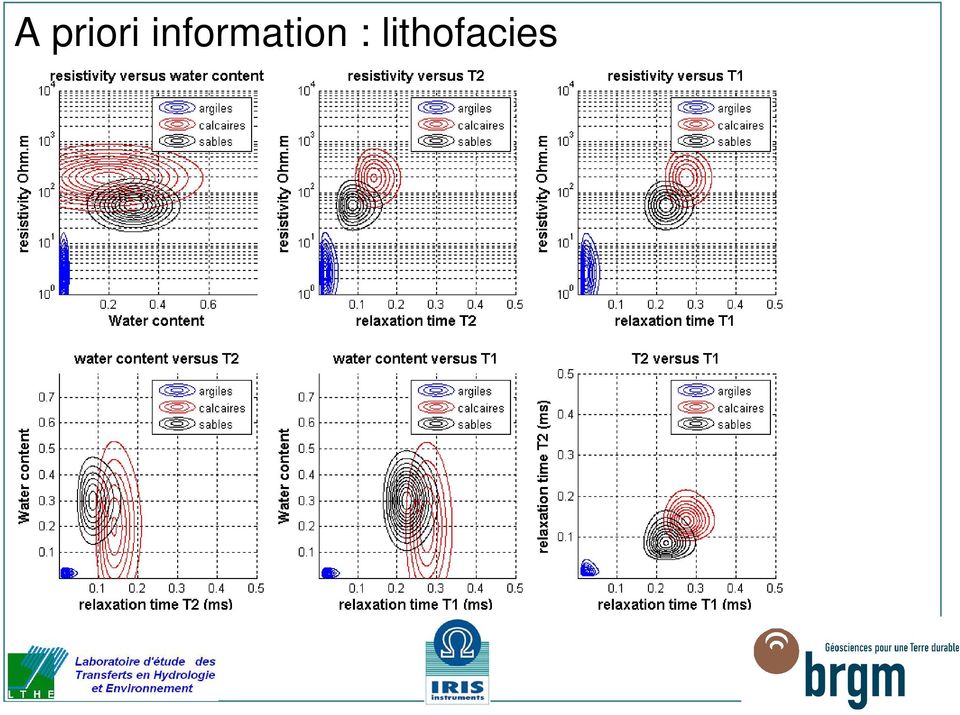
9 A priori information : lithofacies

10 A priori information : lithofacies
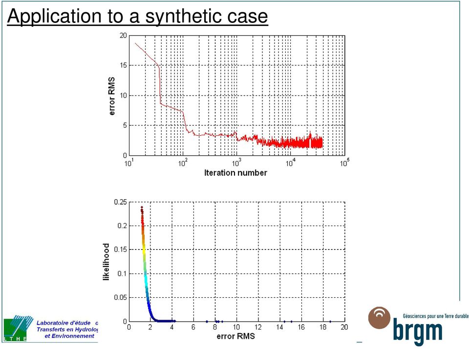
11 Application to a synthetic case > Inversion of a synthetic VES / RMP dataset with 5% gaussian noise Clay Aquifer n 1 Sand Clay Aquifer n 2 Limestone

12 Application to a synthetic case
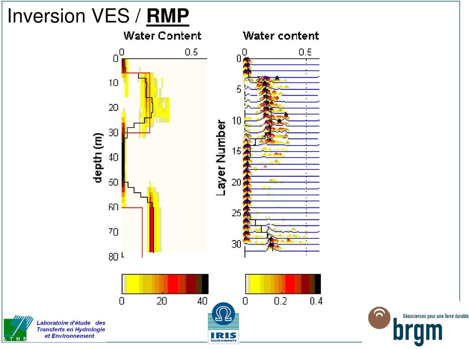
13 Inversion VES / RMP MRS water content (%) Likelihood
")
14 Inversion VES / RMP Quantitative interpretation Rho (Ohm.m) Likelihood

15 Correlation matrix resolution matrix Correlation matrix: rho parameter Correlation matrix: water content parameter Layers strongly dependent = 1 single layer Strong anti-correlation = equivalence phenomenon = limit of resolution without additional extern contraint

16 Smooth model inversion > Mesh is composed of 30 layers 2 meters thick + half-space

17 Inversion VES / RMP
18 Inversion VES / RMP

19 Inversion VES / RMP

20 Characterization of heterogeneous near-surface materials by joint stochastic approach > Joint inversion of geophysical data Reduce equivalence problem by multiphysics / independent methods «facies» inversion (lithologic inversion etc..) > Stochastic approach (Metropolis algorithm) Statistical results of interpretation Sensitivity and accuracy estimation of the model Scenarii Analysis (filtering the satisfying models trhough additional criteria) > Outlooks Seismic (SASW) integration with MRS and electrical methods Use physical laws (Archie etc..) between parameters as an additional constraint Apply it in 2D / 3D (MRS is ruled by linear with water content equations: fast!) Use spatial variability as an input information (correlation length etc..)
 > Outlooks Seismic (SASW) integration with MRS and electrical methods Use physical laws (Archie etc.")
21 Characterization of heterogeneous near-surface materials by joint stochastic approach > Joint inversion of geophysical data Reduce equivalence problem by multiphysics / independent methods «facies» inversion (lithologic inversion etc..) > Stochastic approach (Metropolis algorithm) Statistical results of interpretation Sensitivity and accuracy estimation of the model Scenarii Analysis (filtering the satisfying models trhough additional criteria) > Outlooks Seismic (SASW) integration with MRS and electrical methods Use physical laws (Archie etc..) between parameters as an additional constraint Apply it in 2D / 3D (MRS is ruled by linear with water content equations: fast!) Use spatial variability as an input information (correlation length etc..)
22 Characterization of heterogeneous near-surface materials by joint stochastic approach > Joint inversion of geophysical data Reduce equivalence problem by multiphysics / independent methods «facies» inversion (lithologic inversion etc..) > Stochastic approach (Metropolis algorithm) Statistical results of interpretation Sensitivity and accuracy estimation of the model Scenarii Analysis (filtering the satisfying models trhough additional criteria) > Outlooks Seismic (SASW) integration with MRS and electrical methods Use physical laws (Archie etc..) between parameters as an additional constraint Apply it in 2D / 3D (MRS is ruled by linear with water content equations: fast!) Use spatial variability as an input information (correlation length etc..)
23 2D 3D MR tomography Girard Jean-François, Legtchenko A.
24 From interpolation of 1D results towards a true 2D/3D tomography. Elevation (m) W E 0 ME29 ME10 ME20 sand aquifer ME Distance (m) ME49 ME06 chalk aquifer Test-site Montreuil-sur-Epte: 2D vertical section (above) & wter content map (right) ME Water content (%)
25 West 140 East Elevation (m) ProfileP Distance (m) Elevation (m) Profile P Distance (m) Elevation (m) Profile P Distance (m) Electrical resistivity (Ohm.m)
26 B-PZ2 A Z Y X C L I K J H D G E F Profil P2: RMP en profilage 1D Teneur en eau RMP (%) B-PZ2 A Z Y X C L I K J Temps de relaxation T2*(z) en ms H D G E F Profil P2: RMP en profilage 1D
27 Conclusion > A new methodology with a large potential of application > After the project (end in december 2009) Industrializing the prototype in a commercial equipment Diffusion of the methodology and the results of the onsite validation > Thanks for your attention!
28 Recent bibliography Girard, J-F., Boucher M., Legchenko A, Baltassat J-M., 2007, 2D magnetic resonance tomography applied to karstic conduit imaging, Journal of Applied Geophysics 63, Girard, J-F., Baltassat J-M., Boucher M., Legchenko A., Vouillamoz J-M., Gutierrez A., Noyer M-L., Lachassagne P., 2007, Aquifers imagery and hydrodynamic parameters estimation using proton Magnetic Resonance Soundings. Aquifers systems management: Darcy s legacy in a world of impending water shortage: selected papers from the International Association of Hydrogeologists (IAH) Dijon Symposium, 30th May-1 June 2006, Dijon, France, Taylor & Francis / Balkema, part I, chap. 6, p Legchenko A., Ezersky M., Camerlynck C., Al-Zoubi A., Chalikakis K. and Girard J-F., Locating water-filled karst caverns and estimating their volume using magnetic resonance soundings, Geophysics,vol. 73, n. 5, sept-oct 2008; pp. G51 G61. J.-F. Girard, A. Legchenko, M. Boucher, J-M. Baltassat, Numerical study of the variations of magnetic resonance signals caused by surface slope, Journal of Applied Geophysics 66 (2008) A. Legchenko, M. Ezersky, J-F. Girard, J-M. Baltassat, M. Boucher, C. Camerlynck, A. Al- Zoubi, Interpretation of magnetic resonance soundings in rocks with high electrical conductivity, Journal of Applied Geophysics 66 (2008)
Building the Wireline Database and Calculation of Reservoir Porosity
 This presentation is a publication of the Bureau of Economic Geology at The University of Texas at Austin. Although it is posted here as a source of public information, those wishing to use information
Annealing Techniques for Data Integration
 Reservoir Modeling with GSLIB Annealing Techniques for Data Integration Discuss the Problem of Permeability Prediction Present Annealing Cosimulation More Details on Simulated Annealing Examples SASIM
Application of Nuclear Magnetic Resonance in Petroleum Exploration
 Application of Nuclear Magnetic Resonance in Petroleum Exploration Introduction Darko Tufekcic, consultant email: darkotufekcic@hotmail.com Electro-magnetic resonance method (GEO-EMR) is emerging as the
CALCULATION OF TRANSVERSE RESISTANCE
 Lebanese Science Journal, Vol. 11, No. 1, 2010 105 CALCULATION OF TRANSVERSE RESISTANCE TO CORRECT AQUIFER RESISTIVITY OF GROUNDWATER SATURATED ZONES : IMPLICATIONS FOR ESTIMATING ITS HYDROGEOLOGICAL PROPERTIES
Barometric Effects on Transducer Data and Groundwater Levels in Monitoring Wells D.A. Wardwell, October 2007
 Barometric Effects on Transducer Data and Groundwater Levels in Monitoring Wells D.A. Wardwell, October 2007 Barometric Effects on Transducer Data Barometric Fluctuations can Severely Alter Water Level
TABLE OF CONTENTS PREFACE INTRODUCTION
 TABLE OF CONTENTS PREFACE The Seismic Method, 2 The Near-Surface, 4 The Scope of Engineering Seismology, 12 The Outline of This Book, 22 INTRODUCTION Chapter 1 SEISMIC WAVES 1.0 Introduction, 27 1.1 Body
Groundwater Training Course SOPAC, April 2005. Electromagnetic (EM) Induction method for Groundwater Investigations
 Induction method for Groundwater Investigations") Groundwater Training Course SOPAC, April 2005 Electromagnetic (EM) Induction method for Groundwater Investigations Electromagnetic (EM) Induction Method Basic principle: An AC electric current is applied
Groundwater Training Course SOPAC, April 2005 Electromagnetic (EM) Induction method for Groundwater Investigations Electromagnetic (EM) Induction Method Basic principle: An AC electric current is applied
DELPH v3.0. seabed mapping software suite
 DELPH v3.0 seabed mapping software suite DELPH seabed mapping software suite DELPH SEISMIC, DELPH SONAR and DELPH MAG are complete software packages with dedicated acquisition, processing and interpretation
Tight Gas Reservoirs R&D Project Approach
 Tight Gas Reservoirs R&D Project Approach EBN TNO Tight Gas Symposium Utrecht, September 19, 2006 Tight Gas Reservoirs: some definitions Applies to the sandstone and carbonate reservoirs, with all type
3D stochastic modelling of litho-facies in The Netherlands
 3D stochastic modelling of litho-facies in The Netherlands Jan L. Gunnink, Jan Stafleu, Freek S. Busschers, Denise Maljers TNO Geological Survey of the Netherlands Contributions of: Armin Menkovic, Tamara
How To Map A Lake In The North Of The Holland (Fiji)
") 1. Hydrogelogical mapping Jiri Sima Aim of HG map Groundwater and rocks qualitative permeability and quantitative potential of rock units aquifers / aquitards / aquiclides Water points (spatial distribution
1. Hydrogelogical mapping Jiri Sima Aim of HG map Groundwater and rocks qualitative permeability and quantitative potential of rock units aquifers / aquitards / aquiclides Water points (spatial distribution
WELL LOGGING TECHNIQUES WELL LOGGING DEPARTMENT OIL INDIA LIMITED
 WELL LOGGING TECHNIQUES WELL LOGGING DEPARTMENT OIL INDIA LIMITED The Hydrocarbon E & P Process In the exploration process, a most probable hydrocarbon bearing rock structure is defined based on seismic
For Water to Move a driving force is needed
 RECALL FIRST CLASS: Q K Head Difference Area Distance between Heads Q 0.01 cm 0.19 m 6cm 0.75cm 1 liter 86400sec 1.17 liter ~ 1 liter sec 0.63 m 1000cm 3 day day day constant head 0.4 m 0.1 m FINE SAND
A GIS BASED GROUNDWATER MANAGEMENT TOOL FOR LONG TERM MINERAL PLANNING
 A GIS BASED GROUNDWATER MANAGEMENT TOOL FOR LONG TERM MINERAL PLANNING Mauro Prado, Hydrogeologist - SRK Consulting, Perth, Australia Richard Connelly, Principal Hydrogeologist - SRK UK Ltd, Cardiff, United
Medical Image Processing on the GPU. Past, Present and Future. Anders Eklund, PhD Virginia Tech Carilion Research Institute andek@vtc.vt.
 Medical Image Processing on the GPU Past, Present and Future Anders Eklund, PhD Virginia Tech Carilion Research Institute andek@vtc.vt.edu Outline Motivation why do we need GPUs? Past - how was GPU programming
Numerical Modelling of Water Flow (Seepage) in the Karun 4 Dam and Abutments (Steady State)
 in the Karun 4 Dam and Abutments (Steady State)") Numerical Modelling of Water Flow (Seepage) in the Karun 4 Dam and Abutments (Steady State) Mohammad Hosseiny Sohi 03 November 2015 Contents: Objectives Karun River & Karun 4 Dam in Iran Geology of dam
Numerical Modelling of Water Flow (Seepage) in the Karun 4 Dam and Abutments (Steady State) Mohammad Hosseiny Sohi 03 November 2015 Contents: Objectives Karun River & Karun 4 Dam in Iran Geology of dam
Groundwater flow systems theory: an unexpected outcome of
 Groundwater flow systems theory: an unexpected outcome of early cable tool drilling in the Turner Valley oil field K. Udo Weyer WDA Consultants Inc. weyer@wda-consultants.com Introduction The Theory of
Figure 2-10: Seismic Well Ties for Correlation and Modelling. Table 2-2: Taglu Mapped Seismic Horizons
 GEOPHYSICAL ANALYSIS Section 2.2 P-03 Synthetic Well Tie P-03 V sh Well Tie (checkshot corrected) Time (s) Velocity Density Impedance V sh Synthetic Seismic (m/s) (g/cm 3 ) HD/KB Trace Number GR 20 30V
Periodical meeting CO2Monitor. Leakage characterization at the Sleipner injection site
 Periodical meeting CO2Monitor Leakage characterization at the Sleipner injection site Stefano Picotti, Davide Gei, Jose Carcione Objective Modelling of the Sleipner overburden to study the sensitivity
Electromagnetic surveying
 Electromagnetic surveying Dr. Laurent Marescot laurent@tomoquest.com 1 Introduction Electrical surveying Resistivity method Induced polarization method (IP) Self-potential (SP) method Higher frequency
Matt Harris, Golder Associates (NZ) Ltd. The value of geophysics as a non-intrusive method for site characterisation
 Ltd. The value of geophysics as a non-intrusive method for site characterisation") Matt Harris, Golder Associates (NZ) Ltd. The value of geophysics as a non-intrusive method for site characterisation Presentation Outline What is geophysics and how can it help me? Electrical Resistivity
Matt Harris, Golder Associates (NZ) Ltd. The value of geophysics as a non-intrusive method for site characterisation Presentation Outline What is geophysics and how can it help me? Electrical Resistivity
Detection of water leakage using laser images from 3D laser scanning data
 Detection of water leakage using laser images from 3D laser scanning data QUANHONG FENG 1, GUOJUAN WANG 2 & KENNERT RÖSHOFF 3 1 Berg Bygg Konsult (BBK) AB,Ankdammsgatan 20, SE-171 43, Solna, Sweden (e-mail:feng@bergbyggkonsult.se)
RESERVOIR GEOSCIENCE AND ENGINEERING
 RESERVOIR GEOSCIENCE AND ENGINEERING APPLIED GRADUATE STUDIES at IFP School from September to December RGE01 Fundamentals of Geoscience I Introduction to Petroleum Geosciences, Sedimentology RGE02 Fundamentals
Avez-vous entendu parler du Compressed sensing? Atelier Inversion d ISTerre 15 Mai 2012 H-C. Nataf
 Avez-vous entendu parler du Compressed sensing? Atelier Inversion d ISTerre 15 Mai 2012 H-C. Nataf Compressed Sensing (CS) Candès & Wakin, 2008 15 Mai 2012 Atelier Inversion d'isterre 2 15 Mai 2012 Atelier
1.72, Groundwater Hydrology Prof. Charles Harvey Lecture Packet #2: Aquifers, Porosity, and Darcy s Law. Lake (Exposed Water Table)
") 1.72, Groundwater Hydrology Prof. Charles Harvey Lecture Packet #2: Aquifers, Porosity, and Darcy s Law Precipitation Infiltration Lake (Exposed Water Table) River Water table Saturated zone - Aquifer
1.72, Groundwater Hydrology Prof. Charles Harvey Lecture Packet #2: Aquifers, Porosity, and Darcy s Law Precipitation Infiltration Lake (Exposed Water Table) River Water table Saturated zone - Aquifer
Treatment and longevity in Norwegian soil treatment units
 Treatment and longevity in Norwegian soil treatment units Nordisk konferens Små avlopp Malmø 8-9 feb 2011 Gro Bioforsk Jord og miljø Avdeling for Miljøteknologi og renseprosesser Outline: Wastewater soil
7.2.4 Seismic velocity, attenuation and rock properties
 7.2.4 Seismic velocity, attenuation and rock properties Rock properties that affect seismic velocity Porosity Lithification Pressure Fluid saturation Velocity in unconsolidated near surface soils (the
Stanford Rock Physics Laboratory - Gary Mavko. Basic Geophysical Concepts
 Basic Geophysical Concepts 14 Body wave velocities have form: velocity= V P = V S = V E = K + (4 /3)µ ρ µ ρ E ρ = λ + µ ρ where ρ density K bulk modulus = 1/compressibility µ shear modulus λ Lamé's coefficient
Figure 1: 3D realisation of AST electrode firing head discarging high voltage charge within borehole.
 : crosswell seismic tomography using a repeatable downhole sparker source. William Wills, Roger Marriage*, Avalon Sciences Ltd, James Verdon, Outer Limits Geophysics LLP. Summary Velocity model errors
Diffusione e perfusione in risonanza magnetica. E. Pagani, M. Filippi
 Diffusione e perfusione in risonanza magnetica E. Pagani, M. Filippi DW-MRI DIFFUSION-WEIGHTED MRI Principles Diffusion results from a microspic random motion known as Brownian motion THE RANDOM WALK How
Lists of estimated quantities to be performed and prices Estimated quantities to be performed. Prices
 Schedule No. 2 Payment Schedule Task number according to Schedule No. 1 Scope of task Lists of estimated quantities to be performed and prices Estimated quantities to be performed Prices Date of execution
Satish Pullammanappallil and Bill Honjas. Optim LLC, Reno, Nevada, USA. John N. Louie. J. Andrew Siemens. Siemens & Associates, Bend, Oregon, USA
 Comparative Study of the Refraction Microtremor (ReMi) Method: Using Seismic noise and standard P-wave refraction equipment for deriving 1-D S-wave profiles Satish Pullammanappallil and Bill Honjas Optim
Graduate Courses in Petroleum Engineering
 Graduate Courses in Petroleum Engineering PEEG 510 ADVANCED WELL TEST ANALYSIS This course will review the fundamentals of fluid flow through porous media and then cover flow and build up test analysis
Groundwater exploration WATEX applications with Ground Penetrating Radars. Dr.Saud Amer USGS Dr.Alain Gachet Radar Technologies France
 Groundwater exploration WATEX applications with Ground Penetrating Radars Dr.Saud Amer USGS Dr.Alain Gachet Radar Technologies France GPR is a technology that allows rapid and non destructive collection
FAULT SEAL ANALYSIS: Mapping & modelling. EARS5136 slide 1
 FAULT SEAL ANALYSIS: Mapping & modelling EARS5136 slide 1 Hydrocarbon field structure Compartments 1 km Depth ~2.5km How to produce field? EARS5136 slide 2 Predict flow patterns and communication Fault
Analysis of GS-11 Low-Resistivity Pay in Main Gandhar Field, Cambay Basin, India A Case Study
 5th Conference & Exposition on Petroleum Geophysics, Hyderabad-2004, India PP 162-166 Analysis of GS-11 Low-Resistivity Pay in Main Gandhar Field, Cambay Basin, India A Case Study Ashok Kumar, J.P. Narayan,
Basin simulation for complex geological settings
 Énergies renouvelables Production éco-responsable Transports innovants Procédés éco-efficients Ressources durables Basin simulation for complex geological settings Towards a realistic modeling P. Havé*,
SEG Las Vegas 2008 Annual Meeting. Summary
 Antony PRICE*, Patrick TURPIN, Michel ERBETTA, Total E&P with Don WATTS and Graeme CAIRNS, WesternGeco ElectroMagnetics. Summary Discussed here are the results of a 1D and 3D forward with 1D and 2D inverse
BS PROGRAM IN PETROLEUM ENGINEERING (VERSION 2010) Course Descriptions
 Course Descriptions") BS PROGRAM IN PETROLEUM ENGINEERING (VERSION 2010) Course Descriptions PETE201 Introduction to Petroleum Engineering (Core) (1-0-1) The course's main goal is to provide the student with an overview of
BS PROGRAM IN PETROLEUM ENGINEERING (VERSION 2010) Course Descriptions PETE201 Introduction to Petroleum Engineering (Core) (1-0-1) The course's main goal is to provide the student with an overview of
The foundation of the new sewage plant at le Havre An alternative solution with a preloading embankment
 Titre The foundation of the new sewage plant at le Havre An alternative solution with a preloading embankment F. Baguelin & Seng Y Ung (FONDASOL) F. Gaillard & J.P. Commun (RAZEL) Journée franco-britannique
Reservoir Characterization of Gandhar Pay Sands by integrating NMR log data with conventional open hole logs A Case Study.
 Reservoir Characterization of Gandhar Pay Sands by integrating NMR log data with conventional open hole logs A Case Study. Summary S.K.Dhar* Well Logging Services, Ankleshwar Asset, ONGC Email ID: samirdhar@spemail.org
Neural Networks Tools for Improving Tacite Hydrodynamic Simulation of Multiphase Flow Behavior in Pipelines
 Oil & Gas Science and Technology Rev. IFP, Vol. 56 (2001), No. 5, pp. 471-478 Copyright 2001, Éditions Technip Neural Networks Tools for Improving Tacite Hydrodynamic Simulation of Multiphase Flow Behavior
Marine broadband seismic: Is the earth response helping the resolution revolution? N. Woodburn*, A. Hardwick, and R. Herring, TGS
 Marine broadband seismic: Is the earth response helping the resolution revolution? N. Woodburn*, A. Hardwick, and R. Herring, TGS Summary Broadband seismic aims to provide a greater richness of both (a),
7 Periodical meeting CO2Monitor. Synthetic seismograms from the Sleipner injection site
 7 Periodical meeting CO2Monitor Synthetic seismograms from the Sleipner injection site Davide Gei, Stefano Picotti, Jose Carcione Objective Modelling of the Sleipner overburden to study the sensitivity
XXXVIII IAH Congress
 XXXVIII IAH Congress Groundwater Quality Sustainability Krakow, 12 17 September 2010 Extended Abstracts Editors: Andrzej Zuber Jarosław Kania Ewa Kmiecik University of Silesia Press 2010 abstract id: 211
P02 Calibration of Density Driven Flow Model for the Freshwater Lens beneath the North Sea Island Borkum by Geophysical Data
 P02 Calibration of Density Driven Flow Model for the Freshwater Lens beneath the North Sea Island Borkum by Geophysical Data H. Sulzbacher (LIAG), H. Wiederhold* (LIAG), M. Grinat (LIAG), J. Igel (LIAG),
Signal to Noise Instrumental Excel Assignment
 Signal to Noise Instrumental Excel Assignment Instrumental methods, as all techniques involved in physical measurements, are limited by both the precision and accuracy. The precision and accuracy of a
Integration of reservoir simulation with time-lapse seismic modelling
 Integration of reservoir simulation with seismic modelling Integration of reservoir simulation with time-lapse seismic modelling Ying Zou, Laurence R. Bentley, and Laurence R. Lines ABSTRACT Time-lapse
sufilter was applied to the original data and the entire NB attribute volume was output to segy format and imported to SMT for further analysis.
 Channel and fracture indicators from narrow-band decomposition at Dickman field, Kansas Johnny Seales*, Tim Brown and Christopher Liner Department of Earth and Atmospheric Sciences, University of Houston,
Geothermal. . To reduce the CO 2 emissions a lot of effort is put in the development of large scale application of sustainable energy.
 Geothermal Energy With increasing fossil fuel prices, geothermal energy is an attractive alternative energy source for district heating and industrial heating. In recent years the use of geothermal energy
Laboratory scale electrical resistivity measurements to monitor the heat propagation within porous media for low enthalpy geothermal applications
 32 CONVEGNO NAZIONALE 19-21 Novembre 2013 TRIESTE Laboratory scale electrical resistivity measurements to monitor the heat propagation within porous media for low enthalpy geothermal applications N. Giordano
Vulnerability Assessment
 Vulnerability Assessment VULNERABILITY As used in this report, vulnerability refers to the sensitivity of groundwater to contamination, and is determined by intrinsic characteristics of the aquifer. It
Developing a Safety Case for Ontario Power Generation s L&ILW Deep Geologic Repository
 Developing a Safety Case for Ontario Power Generation s L&ILW Deep Geologic Repository T. Kempe, P. Gierszewski, R. Heystee, M. Jensen and H. Leung Ontario Power Generation, Canada NEA/EC/IAEA Symposium
P-83 Lawrence Berkeley National Laboratory High-Resolution Reservoir Characterization Using Seismic, Well, and Dynamic Data
 P-83 Lawrence Berkeley National Laboratory High-Resolution Reservoir Characterization Using Seismic, Well, and Dynamic Data Permeability field derived from inversion of water-cut data in the highly heterogeneous
INVESTIGATION OF BRIDGE FOUNDATION SITES IN KARST TERRANE VIA MULTI-ELECTRODE ELECTRICAL RESISTIVITY
 INVESTIGATION OF BRIDGE FOUNDATION SITES IN KARST TERRANE VIA MULTI-ELECTRODE ELECTRICAL RESISTIVITY Dennis R. Hiltunen (drh5@psu.edu) 1 and Mary J. S. Roth (rothm@lafayette.edu) 2 1 Associate Professor
Integration of Geological, Geophysical, and Historical Production Data in Geostatistical Reservoir Modelling
 Integration of Geological, Geophysical, and Historical Production Data in Geostatistical Reservoir Modelling Clayton V. Deutsch (The University of Alberta) Department of Civil & Environmental Engineering
Incorporating Internal Gradient and Restricted Diffusion Effects in Nuclear Magnetic Resonance Log Interpretation
 The Open-Access Journal for the Basic Principles of Diffusion Theory, Experiment and Application Incorporating Internal Gradient and Restricted Diffusion Effects in Nuclear Magnetic Resonance Log Interpretation
Principles of groundwater flow
 Principles of groundwater flow Hydraulic head is the elevation to which water will naturally rise in a well (a.k.a. static level). Any well that is not being pumped will do for this, but a well that is
Module 1 : Site Exploration and Geotechnical Investigation. Lecture 5 : Geophysical Exploration [ Section 5.1 : Methods of Geophysical Exploration ]
![Module 1 : Site Exploration and Geotechnical Investigation. Lecture 5 : Geophysical Exploration [ Section 5.1 : Methods of Geophysical Exploration ]](/thumbs/40/20679662.jpg "Module 1 : Site Exploration and Geotechnical Investigation. Lecture 5 : Geophysical Exploration [ Section 5.1 : Methods of Geophysical Exploration ]") Objectives In this section you will learn the following General Overview Different methods of geophysical explorations Electrical resistivity method Seismic refraction method 5 Geophysical exploration
Objectives In this section you will learn the following General Overview Different methods of geophysical explorations Electrical resistivity method Seismic refraction method 5 Geophysical exploration
Sélection adaptative de codes polyédriques pour GPU/CPU
 Sélection adaptative de codes polyédriques pour GPU/CPU Jean-François DOLLINGER, Vincent LOECHNER, Philippe CLAUSS INRIA - Équipe CAMUS Université de Strasbourg Saint-Hippolyte - Le 6 décembre 2011 1 Sommaire
PTE505: Inverse Modeling for Subsurface Flow Data Integration (3 Units)
") PTE505: Inverse Modeling for Subsurface Flow Data Integration (3 Units) Instructor: Behnam Jafarpour, Mork Family Department of Chemical Engineering and Material Science Petroleum Engineering, HED 313,
PTE505: Inverse Modeling for Subsurface Flow Data Integration (3 Units) Instructor: Behnam Jafarpour, Mork Family Department of Chemical Engineering and Material Science Petroleum Engineering, HED 313,
Modeling and Simulation of Oil-Water Flows with Viscous Fingering in Heterogeneous Porous Media.
 ACMA 2014 Modeling and Simulation of Oil-Water Flows with Viscous Fingering in Heterogeneous Porous Media. H. DJEBOURI 1, S. ZOUAOUI 1, K. MOHAMMEDI 2, and A. AIT AIDER 1 1 Laboratoire de Mécanique Structure
Computer Vision for Quality Control in Latin American Food Industry, A Case Study
 Computer Vision for Quality Control in Latin American Food Industry, A Case Study J.M. Aguilera A1, A. Cipriano A1, M. Eraña A2, I. Lillo A1, D. Mery A1, and A. Soto A1 e-mail: [jmaguile,aciprian,dmery,asoto,]@ing.puc.cl
ALL GROUND-WATER HYDROLOGY WORK IS MODELING. A Model is a representation of a system.
 ALL GROUND-WATER HYDROLOGY WORK IS MODELING A Model is a representation of a system. Modeling begins when one formulates a concept of a hydrologic system, continues with application of, for example, Darcy's
APPLICATION OF THE GEO-EMR METHOD IN HYDROGEOPHYSICS
 NOVITOVI ALEKSANDAR 1, ŠESTAK ALEKSANDAR 1 APPLICATION OF THE GEO-EMR METHOD IN HYDROGEOPHYSICS During the recent decade, several new geophysical techniques have been introduced for mapping subsurface
Introduction to Petroleum Geology and Geophysics
 GEO4210 Introduction to Petroleum Geology and Geophysics Geophysical Methods in Hydrocarbon Exploration About this part of the course Purpose: to give an overview of the basic geophysical methods used
Broadband seismic to support hydrocarbon exploration on the UK Continental Shelf
 Broadband seismic to support hydrocarbon exploration on the UK Continental Shelf Gregor Duval 1 1 CGGVeritas Services UK Ltd, Crompton Way, Manor Royal Estate, Crawley, RH10 9QN, UK Variable-depth streamer
Integrated Reservoir Asset Management
 Integrated Reservoir Asset Management Integrated Reservoir Asset Management Principles and Best Practices John R. Fanchi AMSTERDAM. BOSTON. HEIDELBERG. LONDON NEW YORK. OXFORD. PARIS. SAN DIEGO SAN FRANCISCO.
GEOPHYSICAL TESTING OF ROCK AND ITS RELATIONSHIPS TO PHYSICAL PROPERTIES FINAL REPORT
 GEOPHYSICAL TESTING OF ROCK AND ITS RELATIONSHIPS TO PHYSICAL PROPERTIES FINAL REPORT Sponsored by the Florida Department of Transportation Research Center Contract Number BDK-75-977-1 Dr. Dennis R. Hiltunen,
Agilent Creating Multi-tone Signals With the N7509A Waveform Generation Toolbox. Application Note
 Agilent Creating Multi-tone Signals With the N7509A Waveform Generation Toolbox Application Note Introduction Of all the signal engines in the N7509A, the most complex is the multi-tone engine. This application
ARES AUTOMATIC RESISTIVITY & IP SYSTEM. 850 W - 2000 V p-p - 5 A Transmitter for all Multi-Electrode and Manual Modes Up to 10 Adjustable IP Windows
 ARES AUTOMATIC RESISTIVITY & IP SYSTEM 850 W - 2000 V p-p - 5 A Transmitter for all Multi-Electrode and Manual Modes Up to 10 Adjustable IP Windows 2D/3D Resistivity & IP Tomography VES, RP, SP Measurements
Neutrons as a multifunctional tool for geophysicists
 Neutrons as a multifunctional tool for geophysicists Urszula Woźnicka Tomasz Zorski H. Niewodniczanski Institute AGH University of Science of Nuclear Physics, PAN and Technology Kraków, Poland Kraków,
Groundwater Potential of Basement Aquifers in Part of Southwestern Nigeria
 American International Journal of Contemporary Research Vol. 3 No. 3; March 2013 Groundwater Potential of Basement Aquifers in Part of Southwestern Nigeria Yinusa Ayodele Asiwaju-Bello Department of Marine
Eagle Ford Shale Exploration Regional Geology meets Geophysical Technology. Galen Treadgold Bruce Campbell Bill McLain
 Eagle Ford Shale Exploration Regional Geology meets Geophysical Technology Galen Treadgold Bruce Campbell Bill McLain US Shale Plays Unconventional Reservoirs Key Geophysical Technology Seismic Acquisition
Travel Time Modelling using Gamma Ray and Resistivity Log in Sand Shale Sequence of Gandhar Field
 5th Conference & Exposition on Petroleum Geophysics, Hyderabad-2004, India PP 146-151 Travel Time Modelling using Gamma Ray and Resistivity Log in Sand Shale Sequence of Gandhar Field D.N.Tiwary, Birbal
Frequently Asked Questions on the Alberta Tier 1 and Tier 2 Soil and Groundwater Remediation Guidelines. February 2008
 Frequently Asked Questions on the Alberta Tier 1 and Tier 2 Soil and Groundwater Remediation Guidelines February 2008 Frequently Asked Questions on the Alberta Tier 1 and Tier 2 Soil and Groundwater Remediation
D où vient le plomb? :
 D où vient le plomb? : L utilisation de l environmental forensics pour la fixation des objectifs de dépollution du site d une ancienne unité de traitement des métaux précieux à Vienne dans l Isère Yvan
Stochastic control for underwater optimal trajectories CQFD & DCNS. Inria Bordeaux Sud Ouest & University of Bordeaux France
 Stochastic control for underwater optimal trajectories CQFD & DCNS Inria Bordeaux Sud Ouest & University of Bordeaux France CQFD Inria Bordeaux Sud Ouest Departamento de Engenharia Elétrica, USP São Carlos,
Reservoir Characterization and Initialization at Little Mitchell Creek
 Reservoir Characterization and Initialization at Little Mitchell Creek Shuiquan Li L A R A M I E, W Y, J U LY 2 4 T H, 2 0 1 3 Outline Objectives of the project Geological and geophysical results Progress
Technology in the littorals Below the surface and in-shore. Linus Fast R&D Advisor @ SwAF HQ, Naval Dpt linus.fast@foi.se
 Technology in the littorals Below the surface and in-shore Linus Fast R&D Advisor @ SwAF HQ, Naval Dpt linus.fast@foi.se The Baltic Sea: Physical environment Shallow - Mean depth about 60 m Large river
Contributions to high dimensional statistical learning
 Contributions to high dimensional statistical learning Stéphane Girard INRIA Rhône-Alpes & LJK (team MISTIS). 655, avenue de l Europe, Montbonnot. 38334 Saint-Ismier Cedex, France Stephane.Girard@inria.fr
of Geothermal Studies Elizabeth Tavares Pimentel UFAM/ON
 Indications i of an Underground d River beneath the Amazon River: Inferences from Results of Geothermal Studies Elizabeth Tavares Pimentel UFAM/ON Supervisor: Dr. Valiya Mannathal Hamza ON Motivation Fluvial
ARES II ADVANCED MULTI - CHANNEL AUTOMATIC RESISTIVITY & IP SYSTEM
 ARES II ADVANCED MULTI - CHANNEL AUTOMATIC RESISTIVITY & IP SYSTEM 850 W - 2000 Vp-p - 5 A Transmitter with Parallel Power Booster Capability for all Multi-Electrode and Manual Modes 10-channel Receiver
Modelling the Discharge Rate and the Ground Settlement produced by the Tunnel Boring
 Modelling the Discharge Rate and the Ground Settlement produced by the Tunnel Boring Giona Preisig*, Antonio Dematteis, Riccardo Torri, Nathalie Monin, Ellen Milnes, Pierre Perrochet *Center for Hydrogeology
3D Hybrid Gravity Inversion for Base of Salt Modelling
 3D Hybrid Gravity Inversion for Base of Salt Modelling A base of salt test with gravity gradients Gerry Connard, Rob Ellis Tom Popowski and Gaud Pouliquen* Non-Seismic Geophysics, Finding Petroleum Event
PALEOENVIRONMENTS OF THE LAKE BALATON AREA
 Eötvös Loránd University Department of Geophysics HUNGARY 1117 Budapest Pázmány Péter sétány 1/C Tel: +36-1-3812191 Fax: +36-1-3812192 E-mail: geofizika@ludens.elte.hu PALEOENVIRONMENTS OF THE LAKE BALATON
ATTACHMENT 8: Quality Assurance Hydrogeologic Characterization of the Eastern Turlock Subbasin
 ATTACHMENT 8: Quality Assurance Hydrogeologic Characterization of the Eastern Turlock Subbasin Quality assurance and quality control (QA/QC) policies and procedures will ensure that the technical services
DecisionSpace. Prestack Calibration and Analysis Software. DecisionSpace Geosciences DATA SHEET
 DATA SHEET DecisionSpace Prestack Calibration and Analysis Software DecisionSpace Geosciences Key Features Large-volume prestack interpretation and analysis suite Advanced prestack analysis workflows native
CRIIRAD report N. 10-07. Analyses of atmospheric radon 222 / canisters exposed by Greenpeace in Niger (Arlit/Akokan sector)
") CRIIRAD Commission de Recherche et d Information Indépendantes sur la Radioactivité Site : www.criirad.org Tel : + 33 (0)4 75 41 82 50 Fax : + 33 (0)4 75 81 26 48 E-mail : laboratoire@criirad.org Valence,
CRIIRAD Commission de Recherche et d Information Indépendantes sur la Radioactivité Site : www.criirad.org Tel : + 33 (0)4 75 41 82 50 Fax : + 33 (0)4 75 81 26 48 E-mail : laboratoire@criirad.org Valence,
COURSE OUTLINE GEOL 204 MINING COMPUTING 45 HOURS 1.5 CREDITS
 APPLIED SCIENCE AND MANAGEMENT DIVISION School of Science Fall, 2014 COURSE OUTLINE GEOL 204 MINING COMPUTING 45 HOURS 1.5 CREDITS PREPARED BY: Joel Cubley, Instructor DATE: APPROVED BY: Margaret Dumkee,
Principles of Big Data Algorithms and Application for Unconventional Oil and Gas Resources
 SPE-172982-MS Principles of Big Data Algorithms and Application for Unconventional Oil and Gas Resources Avi Lin, Halliburton Copyright 2014, Society of Petroleum Engineers This paper was prepared for
ANNEX D1 BASIC CONSIDERATIONS FOR REVIEWING STUDIES IN THE DETAILED RISK ASSESSMENT FOR SAFETY
 ANNEX D1 BASIC CONSIDERATIONS FOR REVIEWING STUDIES IN THE DETAILED RISK ASSESSMENT FOR SAFETY ANNEX D1: BASIC CONSIDERATIONS FOR REVIEWING STUDIES IN DRA FOR SAFETY D1-1 ANNEX D1 BASIC CONSIDERATIONS
Review of Groundwater Vulnerability Assessment Methods Unsaturated Zone. Dept. of Earth Sciences University of the Western Cape
 Review of Groundwater Vulnerability Assessment Methods Unsaturated Zone Dept. of Earth Sciences University of the Western Cape Background Sililo et al. (2001) Groundwater contamination depends on: Intrinsic
Avizo Inspect New software for industrial inspection and materials R&D
 Avizo Inspect New software for industrial inspection and materials R&D Reduce your design cycle, inspection times, and meet higher-level quality standards at a lower cost. Avizo Inspect software streamlines
Hydrogeology Experiment on Surface-Groundwater Interactions: How Do Our Actions Affect Water Quantity and Quality?
 Name: Period: Hydrogeology Experiment on Surface-Groundwater Interactions: How Do Our Actions Affect Water Quantity and Quality? Purpose/Objective: Students will learn how groundcover influences surface
Tim Johnson, Mike Truex, Jason Greenwood, Chris Strickland, Dawn Wellman: Pacific Northwest National Laboratory
 3D Site Characterization and Autonomous Remedial Process Monitoring Using High Performance Electrical Resistivity and Induced Polarization Tomographic Imaging Tim Johnson, Mike Truex, Jason Greenwood,
Petrophysical Well Log Analysis for Hydrocarbon exploration in parts of Assam Arakan Basin, India
 10 th Biennial International Conference & Exposition P 153 Petrophysical Well Log Analysis for Hydrocarbon exploration in parts of Assam Arakan Basin, India Summary Ishwar, N.B. 1 and Bhardwaj, A. 2 *
Advanced Signal Processing and Digital Noise Reduction
 Advanced Signal Processing and Digital Noise Reduction Saeed V. Vaseghi Queen's University of Belfast UK WILEY HTEUBNER A Partnership between John Wiley & Sons and B. G. Teubner Publishers Chichester New
Groundwater Flooding: a UK Perspective
 Groundwater Flooding: a UK Perspective David Macdonald British Geological Survey Maclean Building Crowmarsh Gifford Wallingford OX10 8BB Tel 01491 838800 NERC All rights reserved Talk outline Definition
On-Line Diagnosis using Orthogonal Multi-Tone Time Domain Reflectometry in a Lossy Cable
 On-Line Diagnosis using Orthogonal Multi-Tone Time Domain Reflectometry in a Lossy Cable Wafa BEN HASSEN*, Fabrice AUZANNEAU*, Luca INCARBONE*, François PERES** and Ayeley P. TCHANGANI** (*) CEA, LIST,