Mobile GIS at Washington State Department of Natural Resources
|
|
|
- Bethanie Lewis
- 4 years ago
- Views:
Transcription

1
2 Mobile GIS at Washington State Department of Natural Resources By Jeffrey Holden

3 Washington DNR Lands 5.6 million acres of state land Aquatic Lands

4 Manage Forests for Schools $300 million annually for schools

5 Regulate Forest Practices

6 Manage State Aquatics Lands

7 Geology Survey

8 Fight Wildfire in Washington

9 Washington DNR Employees 1,500 employees 900 ArcGIS users 500 mobile devices Many different teams each collects different data

10 For Navigation Garmin 60 CSx Custom Map Source base map


11 For Editing in the Field ArcPad Trimble Nomad GPS devices Trimble Pro XT, and XH Antenna
12 Steps to move to mobile 1. Mobile GIS Strategy 2. Prove the new technology works 3. Justify the cost 4. Maps for navigation 5. Develop the editing work flow 6. Train and enable staff

13 Prove the technology works Capitol Forest. Northwest Temperate Rainforest

14 Survey Points 1. Survey points know locations

15 Collect with GPS 2. Collect GPS location with each GPS device at each survey point

16 3. Repeat for many survey points


17 GPS devices tested Collector running on: ipad Android Bluetooth receivers: Trimble R1 GNSS receiver Bad Elf Surveyor Garmin GLO

18 Locate 4. Compare the GPS location at each survey point

19 Measure 5. Measure from survey point to GPS point

20 Samsung Galaxy Tablet Item Cost Accuracy Samsung Galaxy Tablet $ feet Total $149


21 ipad Mini


22 Bluetooth Devices Garmin GLO Bad Elf Surveyor Trimble R1 GNSS Receiver

23 Summary of Devices
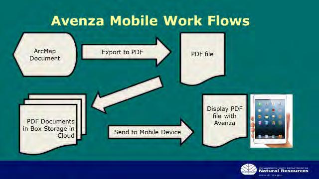
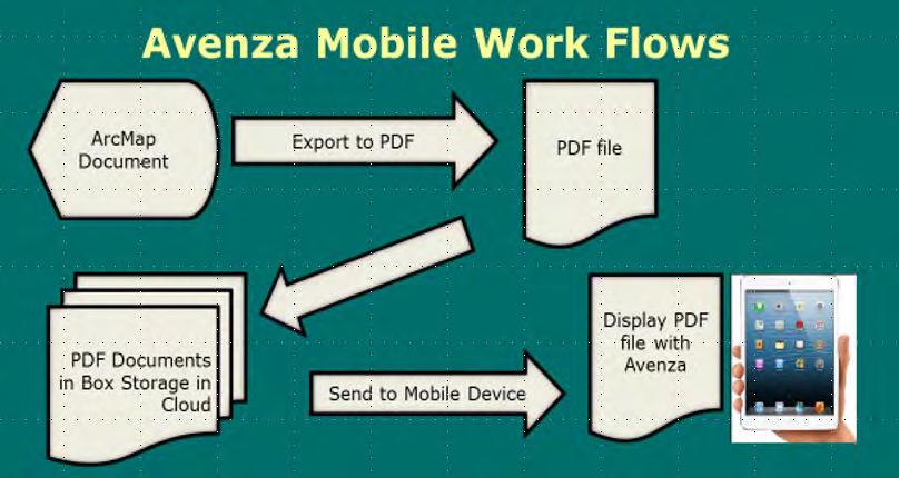
24 Avenza


25 Collector File Geodatabase Using ArcMap or ArcGIS Pro to publish a Feature Service ArcGIS Online Feature Service Sync changes ArcGIS Online Web Map for Collector Download local Area to Mobile Device
26 Collector Groups Base Maps Feature Services
27 Services Feature Services Updated weekly For offline


28 A Web Map for Collector


29 Survey 123 Create Survey 123 Form with Survey 123 Online or Survey 123 Connect Publish Survey 123 Form Survey 123 Feature Service on ArcGIS Online Complete Form on Mobile Device Sync changes


30 Collector and Survey 123 File Geodatabase Create Survey Create Feature Service Publish Survey 123 Form Feature Service on ArcGIS Online Survey on ArcGIS Online ArcGIS Online Web Map for Collector Download Collector Download Survey Form Sync changes To Survey 123 Service

31 Mobile Map Packages Create Mobile Map Package with ArcGIS Pro Upload to Portal or ArcGIS Online Mobile Map Package on Portal or ArcGIS Online, or a file
32 Example Applications DNR has many different teams GIS Analysts develop their Web Maps and editable layers Editors gather data with Collector and/or Survey 123 Mobile GIS Committee recommends: Base maps DNR shared services Publishes services with regular updates

33 Aquatics Geoduck 1. Dives route with Web App Builder Application. 2. Inspection forms are completed with Survey Dashboard and report 4. About 20 users

34 Aquatics Derelict Vessels 1. Derelict vessels 2. Located by County Marine Sheriffs 3. Stored on our GIS Portal 4. Reviewed by DNR

35 Urban Forestry Puget Sound Corps Crews Track Planting, Pruning, invasive species removal Shared with Cities and Counties

36 Land Owner Assistance Program 1. Land Owner Assistance 2. Thinning 3. Reduces forest fuels 4. Homes protected

37 Forest Resources 1. Measure timber volume 2. Plan the harvest 3. Plan regeneration

38 Forest Resources 1. Map the location of Forest Inventory Plots in Collector 2. Link to Survey 123 Form


39 Forest Resources 3. Inventory with Survey 123

40 Geology 1. Create tile packages with LiDAR 2. Map past and potential landslide areas with Collector

41 Forest Practices 1. Roads, culverts, drainage, and road decommissioning 2. Link to Survey Inspection with Survey Custom tile packages


42 Forest Practices Mobile Map Package 1. Download from Portal or ArcGIS Online 2. Viewing only 3. Attributes are available


43 Engineering Bridge Inspections 1. Bridge location in Collector 2. Inspections completed with Survey Updated in ArcGIS Online 4. Synced to Oracle Database nightly
44 Mobile GIS at Washington Department of Natural Resources By Jeffrey Holden
45
Field Data workflows with Collector for ArcGIS Workshop Fall NEARC 2105
 Field Data workflows with Collector for ArcGIS Workshop Fall NEARC 2105 In this workshop, you will learn how to use Collector for ArcGIS to capture locations, information, and photos of assets inside and
Mobile GIS Technology for Efficient Field Data Collection BRIAN GRASS MASON, BRUCE & GIRARD
 Mobile GIS Technology for Efficient Field Data Collection BRIAN GRASS MASON, BRUCE & GIRARD Outline An overview of hardware options Case Study: Sensitive Species and Noxious Weeds Mapping Our Strategy:
How to Setup and Manage Spatial Assets with ArcGIS Online for a Mobile Workforce
 How to Setup and Manage Spatial Assets with ArcGIS Online for a Mobile Workforce W A U R I S A 2 0 1 4 Presented By Engineer Technician II Pierce County Public Works and Utilities Road Operations Division
Manitoba Dutch Elm Disease (DED) Field Data Capture using Collector for ArcGIS and ArcGIS Online
 Field Data Capture using Collector for ArcGIS and ArcGIS Online") Manitoba Dutch Elm Disease (DED) Field Data Capture using Collector for ArcGIS and ArcGIS Online ESRI Regional User Conference Winnipeg, Manitoba April 21, 2015 1 Presentation Outline Business Problem
Manitoba Dutch Elm Disease (DED) Field Data Capture using Collector for ArcGIS and ArcGIS Online ESRI Regional User Conference Winnipeg, Manitoba April 21, 2015 1 Presentation Outline Business Problem
Modern Mobile Technology in Forestry: Choosing the Right Devices, Applications and Data Management Strategy. Kerry Halligan
 Modern Mobile Technology in Forestry: Choosing the Right Devices, Applications and Data Management Strategy Kerry Halligan Mason, Bruce & Girard Natural Resource Consulting Since 1921 Portland, OR Headquarters
The advantages of high accuracy GIS field data collection in the Transportation Industry. MGIS Overview Sergio Hernández
 The advantages of high accuracy GIS field data collection in the Transportation Industry. MGIS Overview Sergio Hernández The big question: Where are our assets? Where do we need improvements? WHERE? Where
Location Referencing for An Asset Management System A State DOT Approach
 Location Referencing for An Asset Management System A State DOT Approach Jack Stickel Alaska Department of Transportation and Public Facilities Traditional Asset Management System Maintenance Management
MINNESOTA DEPARTMENT OF NATURAL RESOURCES. Division of Forestry
 MINNESOTA DEPARTMENT OF NATURAL RESOURCES Division of Forestry Other major programs: Private Forest Management Urban and Community Forestry Insect and Disease Management Urban and Community Forestry
ESRI Mobile GIS Solutions Overview. Shane Clarke ESRI
 ESRI Mobile GIS Solutions Overview Shane Clarke ESRI Agenda Overview of mobile GIS ESRI mobile GIS Solutions Selecting a mobile GIS solution Q & A 2 Mobile GIS Overview 3 What is mobile GIS? Extension
ArcPad a new tool for Asset Inventory/Management at Nevada DOT. Eric Warmath GIS Program Manager, NDOT
 ArcPad a new tool for Asset Inventory/Management at Nevada DOT Eric Warmath GIS Program Manager, NDOT Topics Historical Data Collection Methods Current Methodology Operator Safety Issues Add on Technologies
Note: Hands On workshops are Bring Your Own Laptop (BYOL), unless otherwise noted. Some workshops are Bring Your Own Mobile Device(BYOD).
, unless otherwise noted. Some workshops are Bring Your Own Mobile Device(BYOD).") 2015 MN GIS/LIS Consortium Pre Conference Workshops The Minnesota GIS/LIS Consortium is pleased to offer a diverse list of workshops on Wednesday, October 7th, 2015 at the DECC, Duluth, Minnesota Charting
2015 MN GIS/LIS Consortium Pre Conference Workshops The Minnesota GIS/LIS Consortium is pleased to offer a diverse list of workshops on Wednesday, October 7th, 2015 at the DECC, Duluth, Minnesota Charting
Benefits of Mobile GIS for Public Works
 Benefits of Mobile GIS for Public Works Freese and Nichols, Inc. NCAFPM 2013 Agenda General GIS Concepts Mobile GIS Overview Benefits of Mobile GIS Mobile GIS Project Examples Questions What is GIS? Geographic
Finding Your Assets:
 Finding Your Assets: City of Des Moines Sign Inventory Steve Schunzel GIS Administrator City of Des Moines, WA 2010 WAURISA GIS Conference April 21, 2010 The Problem (Where are our signs?) The Solution
ArcGIS Workflow Manager: An Overview
 Federal GIS Conference February 9 10, 2015 Washington, DC ArcGIS Workflow Manager: An Overview Heather Murnane & Elizabeth Wilcox Session Topics Overview Key Features Notification & Reporting Overview
Overview of Geographic Information System Options. for Invasive Species Management
 Overview of Geographic Information System Options for Invasive Species Management Prepared for the Michigan Invasive Species Coalition by the Potawatomi Resource Conservation and Development Council November,
Essential Mapping Apps
 Essential Mapping Apps 74% of adults use their smartphone to look at maps or other information based on their current location (of the 58% that own a smart phone) Pew Research Center Maps for Directions
Extending Enterprise GIS Into The Field with Mobile GIS Technology
 Extending Enterprise GIS Into The Field with Mobile GIS Technology A White Paper January 10, 2014 1525 Oregon Pike Suite 202 Lancaster, PA 17601-7300 Phone (717) 399-7007 Fax (717) 399-7015 www.geographit.com
ArcGIS Platform. An Integrated System. Portal
 Platform An Integrated System Portal An Integrated Web GIS Platform Knowledge Workers Executive Access Public Engagement Work Anywhere Enterprise Integration Providing Mapping, Analysis, Data Management,
Prepare Data ArcMap Open Trees.mpk Chrome ArcGIS Online New Map Chrome Esri Blogs Chrome Local Government Resources Reflector Phone Connected
 Prepare Data ArcMap Open Trees.mpk Chrome ArcGIS Online New Map Chrome Esri Blogs Chrome Local Government Resources Reflector Phone Connected Kate Firefox http://doc.arcgis.com/en/operations dashboard/
Welcome to Esri's Software Export Control Classification Number (ECCN) Matrix
 Matrix") Welcome to Esri's Software Export Control Classification Number (ECCN) Matrix Updated September 30, 2015 This portion of the Esri web site is to provide information regarding the export control classification
Welcome to Esri's Software Export Control Classification Number (ECCN) Matrix Updated September 30, 2015 This portion of the Esri web site is to provide information regarding the export control classification
TwoDog Forest Inventory Software. Complete Field to Office Forest Inventory Solution for Timber and Non-Timber Values
 TwoDog Forest Inventory Software Complete Field to Office Forest Inventory Solution for Timber and Non-Timber Values TwoDog Forest Inventory Software Complete Field to Office Forest Inventory Solution
Developing Apps with the ArcGIS Runtime SDK for Android. Ben Ramseth Esri Inc. Instructor Technical Lead
 Developing Apps with the ArcGIS Runtime SDK for Android Ben Ramseth Esri Inc. Instructor Technical Lead Ben Ramseth Instructor Technical Lead Esri Inc USA, Charlotte, NC bramseth@esri.com @EsriMapNinja
Esri s ArcPad vs. ArcGIS Mobile vs. Trimble s TerraSync vs. TerraFlex Comparison By: Electronic Data Solutions
 Esri s ArcPad vs. ArcGIS Mobile vs. Trimble s TerraSync vs. TerraFlex Comparison By: Electronic Data Solutions ArcPad is mobile field mapping and data collection software designed for GIS professionals.
Operations Dashboard for ArcGIS
 Federal GIS Conference 2014 February 10 11, 2014 Washington DC Operations Dashboard for ArcGIS Joe Bayles Agenda Esri Strategy toward mobility ios Extend the reach of Web GIS Platform agnostic Native apps/web
Mobile Solutions in ArcGIS. Justin Fan
 Mobile Solutions in ArcGIS Justin Fan Agenda Introducing Mobile GIS Esri Mobile GIS solutions Selecting the right Mobile GIS solution Resources Q&A Introducing Mobile GIS What is Mobile GIS? Extends the
Esri GIS Mobile Solutions. John Sharrard jsharrard@esri.com
 Esri GIS Mobile Solutions John Sharrard jsharrard@esri.com If I had asked people what they wanted, they would have said faster horses. Henry Ford Trend: Increase demand for location services Pew Research
Introduction to ArcPad: Mobile GIS. Originally prepared by Gregory Vandeberg, Ph.D. Department of Geography
 Introduction to ArcPad: Mobile GIS Originally prepared by Gregory Vandeberg, Ph.D. Department of Geography Outline Introduction What is ArcPad? What can you do with ArcPad? What do you need to run it?
REPORT TO REGIONAL WATER SUPPLY COMMISSION MEETING OF WEDNESDAY, SEPTEMBER 4, 2013 LEECH WATER SUPPLY AREA RESTORATION UPDATE
 Making a difference... together Agenda Item #9 REPORT #RWSC 2013-17 REPORT TO REGIONAL WATER SUPPLY COMMISSION MEETING OF WEDNESDAY, SEPTEMBER 4, 2013 SUBJECT LEECH WATER SUPPLY AREA RESTORATION UPDATE
Mobile GIS Guide. About The Author. Getting your mobile GIS project off the ground
 About The Author Matt Sheehan is a mobile GIS pioneer. He and his staff at WebMapSolutions have been providing clients with mobile GIS solutions since the earliest days of smartphones and tablets. We live
Enhancing Asset Management with a GIS Program. Lori A. Burkert, P.G. lburkert@entecheng.com 610-373-6667
 Enhancing Asset Management with a GIS Program Lori A. Burkert, P.G. lburkert@entecheng.com 610-373-6667 presentation overview Definitions Its all about your assets Components of a GIS Why use GIS for asset
Positioning Aware Solutions for Smart Grid. Enterprise Geospatial & Business Development Manager- GIS DC (Trimble, MEIA Region)
") Positioning Aware Solutions for Smart Grid Presented by: Pankaj Gupta Enterprise Geospatial & Business Development Manager- GIS DC (Trimble, MEIA Region) Overview: Position-aware solutions for Smart Grid
Positioning Aware Solutions for Smart Grid Presented by: Pankaj Gupta Enterprise Geospatial & Business Development Manager- GIS DC (Trimble, MEIA Region) Overview: Position-aware solutions for Smart Grid
The LAndscape Management Policy Simulator (LAMPS) Pete Bettinger Department of Forest Resources Oregon State University
 Pete Bettinger Department of Forest Resources Oregon State University") The LAndscape Management Policy Simulator (LAMPS) Pete Bettinger Department of Forest Resources Oregon State University CLAMS Landscape Planning and Analysis Process Existing forest inventories Management
The LAndscape Management Policy Simulator (LAMPS) Pete Bettinger Department of Forest Resources Oregon State University CLAMS Landscape Planning and Analysis Process Existing forest inventories Management
A Method Using ArcMap to Create a Hydrologically conditioned Digital Elevation Model
 A Method Using ArcMap to Create a Hydrologically conditioned Digital Elevation Model High resolution topography derived from LiDAR data is becoming more readily available. This new data source of topography
DISH PAPERLESS AGREEMENTS APP
 DISH PAPERLESS AGREEMENTS APP ONE APP FOR ALL YOUR PAPERLESS AGREEMENTS With the DISH Paperless Agreements app, you can electronically submit new and existing customer agreements from a compatible mobile
Cloud Nine: Developing an Entirely Cloud Based GIS, Asset Management and Work Order System
 Cloud Nine: Developing an Entirely Cloud Based GIS, Asset Management and Work Order System Corrie Bondar 1*, Mark Valentino 2 1 Freese and Nichols, Inc., Raleigh, North Carolina 2 Freese and Nichols, Inc.,
ABSTRACT Utilizing Mobile GIS for Hydrology and Hydraulics Field Reconnaissance
 ABSTRACT Utilizing Mobile GIS for Hydrology and Hydraulics Field Reconnaissance Jessica D. Baker 1, EIT, CFM and Noelle Gaspard 1, CFM Advances in technology have dramatically improved traditional methods
Esri SMART COMMUNITIES
 Esri SMART COMMUNITIES CASE STUDY SERIES Photo: Vern Lindemann THE BENEFITS OF GIS FOR ALL Carver County, Minnesota by Cory Fleming, Senior Technical Specialist, ICMA COMMUNITY PROFILE: Carver County,
I N F O R M A T I O N T E C H N O L O GY. GIS Program. GIS Program plans for migration to web GIS
 C O E U R D A L E N E T R I B E I N F O R M A T I O N T E C H N O L O GY GIS Program Summer 2015 Volume 2; Issue 1 GIS Program plans for migration to web GIS Inside this issue: Web GIS/Portal 1 Collector
Portal for ArcGIS. Satish Sankaran Robert Kircher
 Portal for ArcGIS Satish Sankaran Robert Kircher ArcGIS A Complete GIS Data Management Planning & Analysis Field Mobility Operational Awareness Constituent Engagement End to End Integration Collect, Organize,
Editing Strategies for Enterprise Geodatabase
 Federal GIS Conference February 9 10, 2015 Washington, DC Editing Strategies for Enterprise Geodatabase Ty Fabling Esri Solution Engineer A Complete Platform Enabling GIS Everywhere Desktop Web Device
Penmap Surveying for Everyone. www.penmap.com. Visit us on: www.facebook.com/mypenmap A TRIMBLE COMPANY
 Penmap Surveying for Everyone. Visit us on: www.facebook.com/mypenmap www.penmap.com A TRIMBLE COMPANY Penmap Applications An Open Software for all of your tasks and ideas We at HHK Datentechnik are passionate
Making Your Mobile Workforce More Efficient
 ArcGIS for Mobile Making Your Mobile Workforce More Efficient What Is Mobile GIS? Mobile geographic information system (GIS) technology extends GIS beyond the office and allows organizations to make accurate,
A Workflow for Creating and Sharing Maps
 A Workflow for Creating and Sharing Maps By Keith Mann, Esri What You Will Need Item Source ArcGIS Online for Organizations subscription ArcGIS 10.1 for Desktop (Any license level) ArcGIS Spatial Analyst
Making Your Mobile Workforce More Efficient
 ArcGIS for Mobile Making Your Mobile Workforce More Efficient What Is Mobile GIS? Mobile geographic information system (GIS) technology extends GIS beyond the office and allows organizations to make accurate,
Network Analysis with ArcGIS Online
 Federal GIS Conference February 9 10, 2015 Washington, DC Network Analysis with ArcGIS Online Matt Kennedy Topics Online versus on-premise network analysis services How to access online services How to
Enterprise GIS Architecture Deployment Options. Andrew Sakowicz
 Enterprise GIS Architecture Deployment Options Andrew Sakowicz Audience Audience - Architects - Developers - Administrators - Project Managers Level: - Beginner / Intermediate Introduction Andrew Sakowicz
Cool New Tools In Network Analysis. Scott Sandusky
 Cool New Tools In Network Analysis Scott Sandusky Cool New Tools in Network Analysis Learn about the new functionality available in the Network Analyst extension and in the ArcGIS Online Network Analysis
getting started with box 1. What is box? 2. Creating an account 3. box functions
 getting started with box 1. What is box? 2. Creating an account 3. box functions What is box? A hard drive in the cloud where you can store your files (pictures, word documents, excel files, PDF files,
Successful Management of Database Changes and Workflow. Chris Mickle Charles Richardson
 Successful Management of Database Changes and Workflow Chris Mickle Charles Richardson International Conference for Environmental Data Management. May 14, 2014 Agenda > About Cardno > Overview DBTracker
GIS Solutions for FTTx Design. David Nelson, GISP
 GIS Solutions for FTTx Design David Nelson, GISP Telecom GIS Manager, Black & Veatch Agenda Intro to GIS Telecom GIS Vision GIS Strategy Project Execution Mobile Online Services Dashboards Client Deliverables
LAR-IAC4 Status and User Group Meeting. October 8, 2015
 LAR-IAC4 Status and User Group Meeting October 8, 2015 Agenda LARIAC Imagery Update LARIAC Status Update LARIAC Update and Training Schedule LARIAC Data Access Methods Additional Derived Data User Presentations
Mobile Devices and Operating Systems: Outline
 Mobile Devices and Operating Systems: Where are they heading and why does it matter? Speaker: Eric Gakstatter Contributing Editor GPS World Editor - Geospatial Solutions Presented at: Minnesota Society
About As. In a team with the best. ESRI Bulgaria is the exclusive distributor of Esri Inc. for Bulgaria. Esri Inc.
 About As ESRI Bulgaria is an IT company, leader in the field of Geographic Information Systems (GIS) on the Bulgarian market. Offering the most advanced high-tech products, solutions and services, ESRI
2015 DES SUMMER INTERNSHIP OPPORTUNITIES
 2015 DES SUMMER INTERNSHIP OPPORTUNITIES Searching for a dynamic, educational and fun-filled summer? Take a look at the summer intern positions available at the New Hampshire Department of Environmental
2015 Spring Training - Trimble Certified Classes
 2015 Spring Training - Trimble Certified Classes We are excited to offer Trimble certified training classes in multiple locations this spring. All classes are at least 70% hands-on and highly recommended
ArcGIS Web Mapping. Sam Berg, esri sberg@esri.com
 ArcGIS Web Mapping Sam Berg, esri sberg@esri.com Agenda ArcGIS and WebMaps The APIs ArcGIS for Flex Viewer ArcGIS for Silverlight Builder ArcGIS for Sharepoint ArcGIS Application Templates ArcGIS Runtime
Community Tree Inventory: Data Collection
 USDA FOREST SERVICE NORTHEAST CENTER FOR URBAN & COMMUNITY FORESTRY www.umass.edu/urbantree Community Tree Inventory: Data Collection An Introduction - July 2002 United States Department of Agriculture
Setup your university email on your Android smartphone
 Setup your university email on your Android smartphone This guide is designed for student users with an Office365 mailbox who wish to access their University email through an Android device Students starting
ArcGIS Pro. James Tedrick, Esri
 ArcGIS Pro James Tedrick, Esri What you already know Why ArcGIS PRO? Vision The next generation ArcGIS desktop application for the GIS community who need a clean and comprehensive user experience which
PART I DEPARTMENT OF HUMAN RESOURCES DEVELOPMENT 9.097 STATE OF HAWAII 9.099... 9.101 9.103 Class Specifications 9.105 for the
 PART I DEPARTMENT OF HUMAN RESOURCES DEVELOPMENT 9.097 STATE OF HAWAII 9.099............................. 9.101 9.103 Class Specifications 9.105 for the FORESTRY AND WILDLIFE WORKER SERIES This series
Building Applications with ArcGIS Runtime SDK for ios Part II. Eric Ito and Scott Sirowy
 Building Applications with ArcGIS Runtime SDK for ios Part II Eric Ito and Scott Sirowy Building Applications with ArcGIS Runtime SDK for ios Part II Eric Ito and Scott Sirowy 2011 Dev Summit Dodgeball
Hiring a Consulting Forester Jeff Martin
 No. 75 August, 1994 Hiring a Consulting Forester Jeff Martin What is a Consulting Forester? An independent consulting forester (consultant) is a trained professional forester that operates or works for
Prepare your data in ArcGIS for Desktop
 Collector for ArcGIS (ios) Tutorials Prepare your data in ArcGIS for Desktop Create and share a map for data collection Track where collectors went Additional help FAQs Supported data Configure map capabilities
Indiana DNR Division of Forestry. Small Woodlot Owner Consultant Directory
 Indiana DNR Division of Forestry Small Woodlot Owner Consultant Directory This directory and the Indiana Woodlot Owner Resource Series was developed for property owners who have ten acres or less of woodlands.
White Paper. Freeance Mobile for Cityworks
 White Paper Freeance Mobile for Cityworks Version 1.1 May 2012 Freeance Mobile for Cityworks Freeance Mobile for Cityworks 2012.1 is a mobile application for the following smartphones and tablets: iphone
Laydown Yard Asset Tracking for Heavy Civil Construction
 Laydown Yard Asset Tracking for Heavy Civil Construction Linda Chase HCC-6559 Customer Problem Areas Can t find laydown yard assets in yard or job sites? Some companies spend up to $2,500 a week on lost
mcashier User Guide To accept payments To cancel a payment
 mcashier User Guide To accept payments 1. Enter the purchase amount in the app. If desired, you can enter a reference under the amount (e.g. the product name). The reference will appear on the receipt.
Tablet Devices for Offline CAPI - Overview
 Tablet Devices for Offline CAPI - Overview For Customers Written by: Ofer Heijmans - Dooblo Page 1 of 6 2 Table of Contents 1 TABLET DEVICES FOR OFFLINE CAPI SURVEYS... 3 1.1 OVERVIEW... 3 1.2 TABLET SIZES...
Empowering the Field Users in a Utility Enterprise. Lee Nelson PE 3-GIS
 Empowering the Field Users in a Utility Enterprise Lee Nelson PE 3-GIS Introducing 3-GIS Founded in May 2006 2010 Esri s Strategic Gold Partner Award 2011 Esri s Partners Choice Award GTI Strategic Development
Nursery Phone App Tutorial
 Nursery Phone App Tutorial This document is a reference guide to help nurseries navigate Plantbid s phone app. If you require extra assistance please call our support staff at (985) 845-4104. The Plantbid
Android Tablet GIS Solution Transforms Well Inspection for Bucks County Health Department
 Android Tablet GIS Solution Transforms Well Inspection for Bucks County Health Department A Case Study Problem Statement The Bureau of Environmental Health (BEH) within the Bucks County Health Department
OneDrive for Business User Guide
 OneDrive for Business User Guide Contents OneDrive for Business and Office 365... 2 Storing University Information in the Cloud... 2 Signing in... 2 The Office 365 Interface... 3 The OneDrive App... 3
APP CLOCK INTRODUCTION
 APP CLOCK INTRODUCTION The App Clock is a simple and easy to set LCD clock. Download our free app SyncClock into your Android or ios device. You can set all the clock information with the App and synchronize
Forest Management Plan Templates
 Forest Management Plan Templates The following templates as described in the Forestry Schemes Manual 2011 can be used in support of all scheme applications as described in the scheme documents 2014-2020
Introducing BEEKS Proximity Solutions. Developer Kit Gets You Started
 Introducing BEEKS Proximity Solutions BEEKS from BluVision provides industry-leading Bluetooth beacon solutions to enterprises and innovative developers. Leveraging a cutting-edge, cloudbased solution,
8/4/2014. Mobile GIS for Public Works. Ames, Iowa. Background. 2014 APWA National Congress
 Ben McConville, GIS Coordinator City of Ames Public Works Department Mobile GIS for Public Works Corey Mellies, P.E., Operations Manager City of Ames Public Works Department 2014 APWA National Congress
Best practice use of GI within utility companies From Desktop to the Field
 Best practice use of GI within utility companies From Desktop to the Field Agenda IMGS Introduction Historical Use of GI in utilities New Utility Trends GI - Moving off the island into the enterprise Integrated
o is not required 0 is attached; or 0 has been requested.
 ... REQUEST FOR RECORDS DISPOSITION AUTHORITY LEAVE BLANK NARA use onl JOB NUMBER To: NATIONAL ARCHIVES and RECORDS ADMINISTRATION (NIR) 8601 ADELPHI ROAD COLLEGE PARK, MD 20740-6001 1. FROM (Agency or
Appendix A. Pacific Northwest Laws Pertaining to Forest Fire Protection
 Appendix A. Pacific Northwest Laws Pertaining to Forest Fire Protection Overview Family forest owners in Oregon, Washington, and Idaho are subject to a variety of state and local laws related to forest
Evergreen Carbon Capture - 2
 Motivated by our mission to conserve and restore the lands in our region, Forterra s Evergreen Carbon Capture program (ECC) helps companies, organizations and individuals do their part to improve the long-term
How To Use The Elena Mobile App
 Instructions for field-testing the elena mobile app ***Field testing begins on 1 October and runs through 15 November, 2015*** Instructions on how to download and use the elena mobile phone application
 JohnEnloe,Principal StantecConsultingServicesInc. KEY STAFF RESUMES 1. OVERVIEW Introduction For the City of Sparks Tree Assessment Phase II Stantec will provide project management, GIS mapping coordination
MAPMYFITNESS+ GUIDE FOR ANDROID. Spree Customer Service http://support.spreewearables.com
 MAPMYFITNESS+ GUIDE FOR ANDROID COMPATIBLE ANDROID DEVICES An Android Smartphone or Tablet with Bluetooth Smart (or Bluetooth 4.0). Earlier Bluetooth versions will not work. NOTE: The screenshots and directions
Implementing a Mobile GIS. Tom Brenneman Esri
 Implementing a Mobile GIS Tom Brenneman Esri Agenda Mobile GIS Overview ESRI Mobile GIS Solutions - ArcPad - ArcGIS Mobile - ArcGIS for ios Select a Mobile GIS Solution Q&A Mobile GIS Overview ArcGIS 10
Challenges and Success of Migrating to an Enterprise Database in York County, PA
 Challenges and Success of Migrating to an Enterprise Database in York County, PA PA GIS Conference June 16, 2015 Wade Gobrecht York County Planning Commission Andrew Ross GeographIT Source: Can You Draw
Use of GIS in Planning and Asset Management
 Use of GIS in Planning and Asset Management Technology Developments and Practical Uses Jay Adams Oklahoma DOT Pam Jurney Cross Timbers Consulting GIS Is Evolving Rapidly Millions Organizations 100 s
OneDrive for Business User Guide
 OneDrive for Business User Guide Contents OneDrive for Business and Office 365... 2 Storing University Information in the Cloud... 2 Signing in... 2 The Office 365 Interface... 3 The OneDrive App... 3
Request for Proposals for Topographic Mapping. Issued by: Teton County GIS and Teton County Engineering Teton County, Wyoming
 Request for Proposals for Topographic Mapping Issued by: Teton County GIS and Teton County Engineering Teton County, Wyoming Proposals due: 2:00PM MDT July 1, 2015 Proposals may be delivered to: Teton
Oregon. Climate Change Adaptation Framework
 Oregon Climate Change Adaptation Framework Oregon Environmental Quality Commission Climate Change Adaptation Framework Presentation at a glance: Purposes of the framework Participating agencies Climate
IMPERVIOUS SURFACE MAPPING UTILIZING HIGH RESOLUTION IMAGERIES. Authors: B. Acharya, K. Pomper, B. Gyawali, K. Bhattarai, T.
 IMPERVIOUS SURFACE MAPPING UTILIZING HIGH RESOLUTION IMAGERIES Authors: B. Acharya, K. Pomper, B. Gyawali, K. Bhattarai, T. Tsegaye ABSTRACT Accurate mapping of artificial or natural impervious surfaces
How To Use Gis
 Welcome Understanding Purpose Creating Relationships You A Global Community of GIS Professionals Changing the World Together Applying Geography Everywhere Your WORK Showcasing Your Web Apps Vision Applying
Learning about GPS and GIS
 Learning about GPS and GIS Standards 4.4 Understand geographic information systems (G.I.S.). B12.1 Understand common surveying techniques used in agriculture (e.g., leveling, land measurement, building
ENTERPRISE GIS FRAMEWORK. Ian Kidner, GISP GIS Systems Administrator Office of Technical Services
 ENTERPRISE GIS FRAMEWORK Ian Kidner, GISP GIS Systems Administrator Office of Technical Services Agenda Why TIMS What is TIMS Agency Processes Benefits Questions 2 Why TIMS ODOT Mission To provide easy
Lesson 10: Basic Inventory Calculations
 Lesson 10: Basic Inventory Calculations Review and Introduction In the preceding lessons, you learned how to establish and take measurements in sample plots. You can use a program like LMS to calculate
COMBINING WEB AND ONSITE GIS FOR EMERGENCY MANAGEMENT DRILLS. Justin D. Cole, GISP Senior GIS Analyst
 COMBINING WEB AND ONSITE GIS FOR EMERGENCY MANAGEMENT DRILLS Justin D. Cole, GISP Senior GIS Analyst Agenda What is MCU-4 Old Version New Version Differences Real Time Imaging Capabilities Web GIS How
LEARNING RESOURCE CENTRE GUIDE TO OFFICE 365
 LEARNING RESOURCE CENTRE GUIDE TO OFFICE 365 LEARNING RESOURCE CENTRE OCTOBER 2014/2015 Table of Contents Explanation of One Drive and Microsoft Office Online... 3 How to create a document and folder...
OneDrive for Business User Guide
 OneDrive for Business User Guide Contents About OneDrive for Business and Office 365... 2 Storing University Information in the Cloud... 2 Signing in... 2 The Office 365 Interface... 3 The OneDrive for
ExpoBadge Mobile App User Guide
 ExpoBadge Mobile App User Guide ExpoLeads Mobile is an application that can be used to scan, qualify and survey attendees at events and trade shows using smart phones or tablets. It is compatible with
ENVI and ArcGIS Integration Bringing Imagery to GIS
 ITT ENVI and ArcGIS Integration Bringing Imagery to GIS The information contained in this document pertains to software products and services that are subject to the controls of the Export Administration
Mobile GIS - background of processing collected data
 Mobile GIS - background of processing collected data Jakub Šilhavý 1, Karel Jedlička 2 1,2 Geomatics section of Department of Mathematics, Faculty of Applied Sciences, University of West Bohemia, Univerzitní