Positioning Aware Solutions for Smart Grid. Enterprise Geospatial & Business Development Manager- GIS DC (Trimble, MEIA Region)
|
|
|
- Howard Johnston
- 8 years ago
- Views:
Transcription
1 Positioning Aware Solutions for Smart Grid Presented by: Pankaj Gupta Enterprise Geospatial & Business Development Manager- GIS DC (Trimble, MEIA Region)

2 Overview: Position-aware solutions for Smart Grid Handheld based solutions Field Inspection and Maintenance Solution Outage Management Solution Mass Data Collection Solutions- Aerial and Terrestrial Mass Data Collection Solutions- Aerial and Terrestrial Lidar Solution

3 Overview: Position-aware solutions for Smart Grid Gain geospatial context in the field and back office in real time Improve speed and efficiency of data collection Improve quality of service and quality of information Generate ROI and return on geospatial assets Eliminate paper maps and forms

4 Handheld based solutions

5 Trimble Juno Series Juno SA Juno 3B/3D Juno 5B/5D Juno 5D WEHH WEHH WEHH Android Ready to use any windows base GIS application & Trimble Mapping software in the field Low cost per user Windows 6.1 Mobile handheld with 3.5 Screen 2-5 Meter Real Time Accuracy in the field 1-3 Meter Accuracy with Post-Processing Ready to use any windows base GIS application & Trimble Mapping software in the field Connectivity with office and field for real-time results Windows 6.5 Mobile Handheld with 3.5 Screen 5 MP Camera with Geo-tagging facility 2-5 Meter Real Time Accuracy in the field 1-3 Meter Accuracy with Post-Processing Built for GIS field workflow Rugged Device (IP 65) for different field conditions Smart phone form factor with 8 MP Camera & 4.3 Screen Reading capability of 1D and 2D barcode 2-4 Meter Real Time Accuracy 2-4 Meter Accuracy with Post-Processing Available in Android All features available, as in WEHH

6 Trimble Geo Series Geo 5 Geo XT 6000 Geo XH 6000 Geo 7 WEHH WEHH WEHH WEHH Windows Mobile 6.5 Handheld computer with Handheld computer with Handheld computer with based Handheld with integrated high accuracy integrated high accuracy GNSS integrated high accuracy 45 Channels (GPS, GNSS Exceptional GNSS performance GNSS GLONASS, SBAS) Exceptional GNSS in difficult environments For Decimetre & CM Accuracy Sunlight Readable performance in difficult 4.2 Sunlight Readable Screen in the field 3.5 Screen with 3 environments with 5 MP Camera Free installed Rangefinder MP Camera Compatible with Trimble MGIS Software and any windows based GIS Application Work as Base Station also in the field Sub-meter Accuracy in the field 4.2 Sunlight Readable Screen with 5 MP Camera Work Rover as well as Base for Sub-meter Accuracy Field Connectivity with 3.5G Modem Field Swappable Battery with 11 hours operation Work Rover as well as Base for Decimetre and CM Accuracy Field Connectivity with 3.5G Modem Field Swappable Battery with 11 hours operation Utility Trimble Flight-wave Technology Powerful, economic and rugged unit

7 Trimble GPS Pathfinder Series GPS Pathfinder ProXRT Pro 6H/6T GPS Pathfinder ProXRT Flexible GNSS Receiver with Real-Time Decimeter Accuracy Omnistar Capability Rugged Unit (IP67) with 13 Hours Battery Backup in the field NMEA Option Work with Trimble MGIS Handheld units Pro 6H/6T High accuracy GNSS positioning system Easy to use in the field, Bag pack is available Work with Trimble MGIS Handheld units For Decimeter & Submeter accuracy

8 Trimble Yuma 2 Rugged Tablet Yuma 2 Yuma 2 Capacitive display, Integration of Reflective and Transmissive Technologies Take the full GIS in the field Windows 7 operating system Hard Drive storage capacity, Dualmode 3.75G Data Communication option, extended Life batteries, color choices Military Standard Rugged unit 2-4 meter accuracy in the field Duel Camera option available

9 Trimble Nomad Nomad Nomad Rugged Unit with IP68 rating Work in extreme temperature Windows 6.1 Mobile Handheld RS 232, USB, Bluetooth & Wi-Fi as connectivity option Barcode Scanner facility 3.5 Display Compatible with Trimble MGIS Software & and mobile base GIS application 5 MP Autofocus Camera 2-5 Meter Real Time Accuracy

10 Trimble LaserAce 1000 Rangefinder LaserAce 1000 LaserAce 1000 Easy to use, Collect Remote Measurements Increase productivity with Safely Data collection Collect X,Y,Z with the help of Bearings, when collect Tree, Pole heights etc. Rugged Hardware with IP63 Bluetooth can connect with Trimble MGIS Handhelds

11 Trimble MGIS Software GIS Post- Processing Software GIS Data Collection Software GPS Pathfinder Office Software TerraSync Software Windows Base Mobile Application Trimble Position Desktop Add In Trimble Position Mobile Extension Windows Base Mobile Application Trimble Terraflex Cloud Base Mobile Application

12 Utility Asset Mapping Case Study-1 R-APDRP Project in India

13 Electricity Asset Inventory Accelerating New Beginning... R-APDRP in India Restructured Accelerated Power Development & Reforms Program for Electric Distribution Companies in India APDRP Field Data Requirements DGPS Survey Field Data Collection Differential Correction of Raw GPS Data Exporting the Data into GIS Accuracy of Sub Meter Level (< 1 M) Asset Co-ordinates- Longitude & Latitude Regular Maintenance & Update of Field Data Establish Ground Control point Network UTM-WGS84
 Asset Co-ordinates- Longitude & Latitude Regular Maintenance &")
14 Utility Asset Mapping Case Study-2 Kenya Power Pre-Paid Meter & Asset mapping

15 Sportsview Estate in Kasarani, Nairobi North, which was the pilot area for the prepaid metering system 36 52'51.638"E 11 9'29.376"S

16 PROCESS MAP FOR DATA COLLECTION


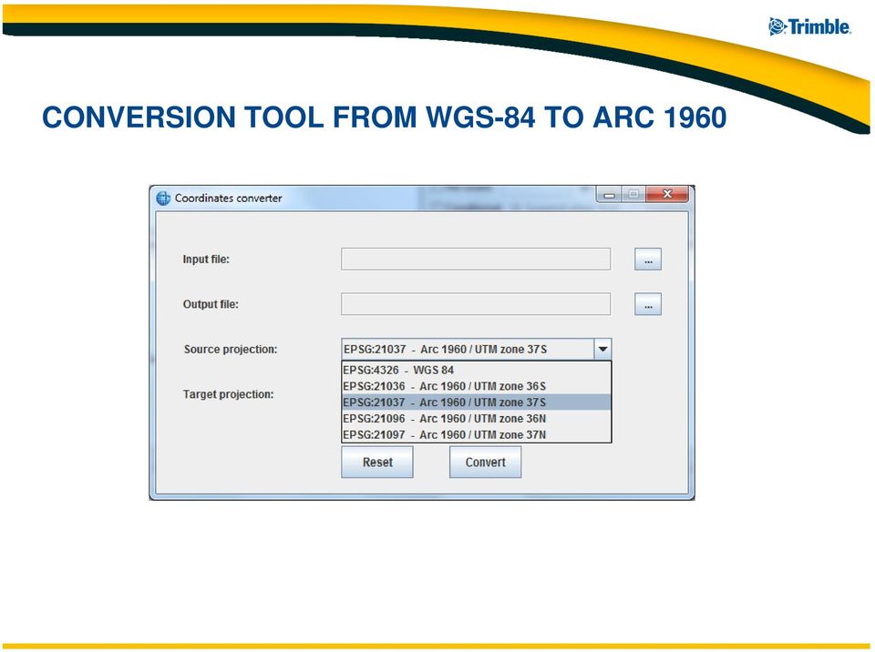
17 CONVERSION TOOL FROM WGS-84 TO ARC 1960
18 KENYA POWER GIS
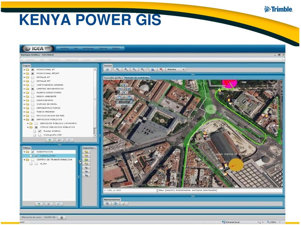

19 Kenya Power Workflow: Update the spatial records only Update server on a real-time basis at KPLC HQ Update the prepaid meter numbers using the barcode reader If no record of the meter exists it captures coordinates as new feature and prompts one to enter attribute details on the data collection form. Connected Office Disconnected Field Crew

20 GPS COORDINATES FORMAT FROM FILE IN.CSV

21 Kenya Power GPS Units: Nomad Geo Terrasync Professional Pathfinder Office- 75+
22 Field Inspection and Maintenance Solution
23 GIS and GPS Based Utility Field Work Management Field Inspector Integrated Work Queue Single List of CIS, O&M Work Orders Mobile GIS and GPS Maps and Redlines Shared with Field Crews
24 Private water utility serving the City of Baton Rouge Louisiana Accurate GIS maps in the field Eliminate inspection paperwork Improve asset management information Increase worker productivity We ve certainly optimized our processes for locating assets, updating maps and drawings, sharing information, and handling repairs using mobile GIS. Having access to the GIS has become an integral part of our field workers jobs. Ryan Scardina, Technical Services Supervisor
25 Automate Meter Change Outs Automate workflows, improve GPS precision and data quality, for improved accuracy, productivity and reduced costs Centrally manage meter deployments and change-outs Use high accuracy GPS to identify meter locations Accurately record data using barcodes and digital photos Direct meter communications via internal or external manufacturer radio integration
26 Enhance Utility Pole Inspections Proactively inspect aging and neglected poles for reduced outages, maximized joint use revenue, and improved system reliability Eliminate the paper record keeping process Instantly record the location and condition of poles Verify joint-use attachments for accounting audits Capture photographs of pole as well as time and date of inspection Plan Work
27 Transmission Line Inspections Safely and accurately perform construction and maintenance inspections on critical electric transmission lines Accurately record the location of encroaching vegetation or report upon the status previous encroaching vegetation Report upon the condition of access roads and locked gates Eliminate the need for paper or a laptop while patrolling lines Instantly notify management of damage or broken equipment
28 Track and Assess Damage in the Field Automatically notify operations managers of the condition of assets soon after major events such as storms, fires, and accidents Efficient reporting for unplanned events Quickly assess damage to help set restoration priorities Capture GPS, photos and GIS redlines of affected areas Integrated directly with your GIS, Outage and facility management programs Damage Assessme nt Areas Navigate to Pole Record Damag e Data Make Redline Notes on Map
29 Outage Management Solution
30 Serving a Range of Utilities Segments Electric Gas Water Communications Initial Planning Project Management Site Preparation Construction Operations Maintenance Feasibility planning Route selection Route Optimization Integrated Lifecycle Management Budget and Schedule Management Heavy Construction Fleet Management Schedule and Dispatch Construction Asset Management GPS Survey Optical Survey Work Management Heavy Construction Fleet Management Schedule and Dispatch Construction Asset Management Spatial Imaging GPS Survey Optical Survey Work Management Building Information Management Mobile Computing Fleet Management Schedule and Dispatch Work Management Asset Management Outage Management GIS Data Collection GIS Data Maintenance GIS Data Use Mobile Computing Fleet Management Schedule and Dispatch Work Management Asset Management Outage Management Geospatial GIS Data Collection GIS Data Maintenance GIS Data Use Mobile Computing
31 Utility Incident and Outage Management System (OMS) Solution Application Features: Network Model Management Incident Identification and Management Incident and Outage Identification and Management Customer Premise Data Management Contact Management Customer Contact and Workforce Management Workforce and Dispatch Management Back-office System Interfaces
32 Electricity Outage Management erespond PEA in Thailand Provincial Electricity Authority Project with SIEMENS ED and IBM 15,000,000 meters 200 concurrent users 3,000 user accounts Many remote users High volume testing Localized in Thai First region live August 2009
33 Mass Data Collection Solutions- Aerial and Terrestrial Lidar Solution
 ecognition")
34 DATA COLLECTION DATA PROCESSING INFORMATION EXTRACTION LAND Mobile Data Capture for Imaging Mobile Data Capture for GIS Mobile Spatial Imaging Trimble Trident 3D Analyst: Spatial Imaging, GIS, & Road sign Extraction AERIAL Aerial Cameras & Imaging Aerial Laser Scanning & Imaging Direct Georeferencing & Flight Mgt Inpho Software: Photogrammetry & Laser Scanning Processing (DTM) ecognition Software: Geospatial Data Fusion Object Based Analysis Complete Geospatial Workflows SATELLITE
35
36 Geospatial Aerial Workflow & Products Flight Data Data Data Feature Management Acquisition Preparation Processing Extraction Flight management system Direct Georeferencing System Optical Sensors LiDAR Sensors Image Mosaicing Point Cloud Matching Orthophoto production Point cloud processing DSM / DTM generation Manual feature extraction Automatic feature extraction
37

38 Geospatial Land Workflow & Products Data Acquisition Data Processing Feature Extraction Optical systems Optical & LiDAR systems Georeferencing Manual feature extraction Automatic feature extraction
39
GPS MAPPING SOLUTIONS
 GPS MAPPING SOLUTIONS Geo Explorer 7 Series Smart data collection By providing compatibility with existing and planned GNSS constellations, the Geo 7X has the smarts to maximize productivity by delivering
Trimble Yuma Rugged Tablet Computer: FAQ for Customers
 4 August 2009 Trimble Yuma Rugged Tablet Computer: FAQ for Customers What is the Trimble Yuma rugged tablet? The Trimble Yuma rugged tablet computer is an all-in-one outdoor computing solution that can
IP-S2 HD. High Definition 3D Mobile Mapping System
 IP-S2 HD High Definition 3D Mobile Mapping System Integrated, turnkey solution High Density, Long Range LiDAR sensor for ultimate in visual detail High Accuracy IMU and DMI Odometry for positional accuracy
GTI s Asset Lifecycle Tracking Program
 GTI s Asset Lifecycle Tracking Program > Northeast Gas Association s Spring Operations Conference April 11, 2013 > Paul Armstrong Bill Gale Gas Technology Institute GTI Overview > Not-for-profit research,
IP-S2 Compact+ 3D Mobile Mapping System
 IP-S2 Compact+ 3D Mobile Mapping System 3D scanning of road and roadside features Delivers high density point clouds and 360 spherical imagery High accuracy IMU options without export control Simple Map,
RESULTS OF THE ITALIAN GPS VALIDATION TEST FOR PARCEL MEASUREMENTS
 RESULTS OF THE ITALIAN GPS VALIDATION TEST FOR PARCEL MEASUREMENTS Introduction SIN s.r.l. and AGEA under the supervision of JRC, in May 2011 have held in Rome, tests for the certification and validation
The advantages of high accuracy GIS field data collection in the Transportation Industry. MGIS Overview Sergio Hernández
 The advantages of high accuracy GIS field data collection in the Transportation Industry. MGIS Overview Sergio Hernández The big question: Where are our assets? Where do we need improvements? WHERE? Where
Customer FAQs for the Yuma 2 Rugged Tablet
 May, 2013 Customer FAQs for the Yuma 2 Rugged Tablet What is the Trimble Yuma 2 rugged tablet computer? The Trimble Yuma 2 is a fully rugged tablet computer with a 7 screen designed for people who need
Esri s ArcPad vs. ArcGIS Mobile vs. Trimble s TerraSync vs. TerraFlex Comparison By: Electronic Data Solutions
 Esri s ArcPad vs. ArcGIS Mobile vs. Trimble s TerraSync vs. TerraFlex Comparison By: Electronic Data Solutions ArcPad is mobile field mapping and data collection software designed for GIS professionals.
Trimble Municipal Reporter
 Introduction to Trimble Municipal Reporter Presenting. Jim Lahm (503) 624-6133 jim@elecdata.com Portland, OR Electronic Data Solutions Specializing in mobile computing and field data collection applications
IP-S3 HD1. Compact, High-Density 3D Mobile Mapping System
 IP-S3 HD1 Compact, High-Density 3D Mobile Mapping System Integrated, turnkey solution Ultra-compact design Multiple lasers minimize scanning shades Unparalleled ease-of-use No user calibration required
RELEASE NOTES. Introduction. New in this release. Trimble Positions Mobile extension
 RELEASE NOTES Trimble Positions Mobile extension These release notes provide important information about the Trimble Positions Mobile extension version 10.2.0.1. Please read these release notes carefully.
Trimble TerraSync User Guide for Laser GPS Offset
 Trimble TerraSync User Guide for Laser GPS Offset Intro Trimble TerraSync software is designed for fast and efficient field GIS data collection and maintenance. Integrating all the ways you collect data
Introduction. Mobile GIS emerged in the mid-1990s to meet the needs of field work such as surveying and utility maintenance.
 Mobile GIS Introduction With more than 6.8 billion mobile cellular subscribers, (2013), wireless communication and mobile computing have gained acceptance worldwide with speed that has surpassed many other
The X100. Safe and fully automatic. Fast and with survey accuracy. revolutionary mapping. create your own orthophotos and DSMs
 The X100 revolutionary mapping Safe and fully automatic create your own orthophotos and DSMs Fast and with survey accuracy operates even in harsh weather conditions (up to 65 km/h wind & light rain) Image
Affordable Mobility, Smart Business Decisions
 Affordable Mobility, Smart Business Decisions Warshaw Group s Mobile Validity Enterprise Application Platform Mobilizes Your Inspection Business, Turns Field Data Collection into Instantly Actionable Real
Benefits of Mobile GIS for Public Works
 Benefits of Mobile GIS for Public Works Freese and Nichols, Inc. NCAFPM 2013 Agenda General GIS Concepts Mobile GIS Overview Benefits of Mobile GIS Mobile GIS Project Examples Questions What is GIS? Geographic
A fool proof Fleet Management System
 A fool proof Fleet Management System for your business providing complete fleet management with customised solutions that not only ensure the safety of your goods, vehicles and personnel, but also enhances
ESRI Mobile GIS Solutions Overview. Shane Clarke ESRI
 ESRI Mobile GIS Solutions Overview Shane Clarke ESRI Agenda Overview of mobile GIS ESRI mobile GIS Solutions Selecting a mobile GIS solution Q & A 2 Mobile GIS Overview 3 What is mobile GIS? Extension
Empowering the Field Users in a Utility Enterprise. Lee Nelson PE 3-GIS
 Empowering the Field Users in a Utility Enterprise Lee Nelson PE 3-GIS Introducing 3-GIS Founded in May 2006 2010 Esri s Strategic Gold Partner Award 2011 Esri s Partners Choice Award GTI Strategic Development
Alberding precision agriculture solutions
 Alberding precision agriculture solutions Alberding GmbH AGRITECHNICA 2015, 8 14 November 2015, Hanover, Germany Presentation by: Tamás Horváth & Katrin Arendholz Alberding GmbH - Precision agriculture
Improve asset visibility, utilization and lifecycle with mobility
 APPLICATION BRIEF: Federal Government Asset Management Improve asset visibility, utilization and lifecycle with mobility For military bases and civilian government agencies alike, mobile computing can
Opportunities for the generation of high resolution digital elevation models based on small format aerial photography
 Opportunities for the generation of high resolution digital elevation models based on small format aerial photography Boudewijn van Leeuwen 1, József Szatmári 1, Zalán Tobak 1, Csaba Németh 1, Gábor Hauberger
Cost-Effective Collection of a Network-Level Asset Inventory. Michael Nieminen, Roadware
 Cost-Effective Collection of a Network-Level Asset Inventory Michael Nieminen, Roadware Introduction This presentation is about using a mobile vehicle to collect roadway asset (feature) data. Asset/Feature
New Technologies for Gas Transmission and Distribution
 New Technologies for Gas Transmission and Distribution Overview GTI and LocusView Company Overview Industry Needs Industry Standards Technology Solutions Case Studies Companies GTI is a not-for-profit
Asset Tracking and Traceability Oklahoma Gas Association. Mike Zandaroski August 28, 2013
 Asset Tracking and Traceability Oklahoma Gas Association Mike Zandaroski August 28, 2013 Why is it important for an operator to be concerned about traceability and tracking of assets? CenterPoint s rational
Mobile 360 Degree Imagery: Cost Effective Rail Network Asset Management October 22nd, 2015. Eric McCuaig, Trimble Navigation
 Mobile 360 Degree Imagery: Cost Effective Rail Network Asset Management October 22nd, 2015 Eric McCuaig, Trimble Navigation The debate: Point Clouds vs. Imagery Both are useful pick the right tool for
Everything you need for your mobile enterprise
 Everything you need for your mobile enterprise A complete software, hardware and managed service solution for mobile workers Spirit Data Capture Limited is an enterprise mobility company. We have an in-depth
ABSTRACT Utilizing Mobile GIS for Hydrology and Hydraulics Field Reconnaissance
 ABSTRACT Utilizing Mobile GIS for Hydrology and Hydraulics Field Reconnaissance Jessica D. Baker 1, EIT, CFM and Noelle Gaspard 1, CFM Advances in technology have dramatically improved traditional methods
Field Service Application
 Field Service Terminal Wi-Fi, and WCDMA/HSDPA or GPRS wireless technology Built-in 1D Laser/2D Imager Scan Engine and Supports Mifare (ISO 14443A) 43A) Felica (ISO 14443B) and ISO 15693 reader 3 Megapixels
GeoMax GNSS Zenith10 & Zenith20 Series
 GeoMax GNSS Zenith10 & Zenith20 Series GeoMax About Us At GeoMax we provide a comprehensive portfolio of integrated solutions by developing, manufacturing and distributing quality construction and surveying
Industries, applications, and configurations
 Industries, applications, and configurations A Beginner s Guide to choosing a rugged Device As the popularity of enterprise tablet computing rapidly increases, so does the variety of industries and applications
Webinar Series: Energy Applications and Cloud Computing
 Webinar Series: Energy Applications and Cloud Computing David Terry ASERTTI Executive Director May 29, 2013 ASERTTI Overview ASERTTI Members Upcoming Activities ASERTTI ASERTTI's mission is to increase
THE ADVANCES OF INTEGRATED GEOSPATIAL APPLICATION IN WORKFORCE MANAGEMENT AND FIELD SERVICE OPTIMIZATION
 THE ADVANCES OF INTEGRATED GEOSPATIAL APPLICATION IN WORKFORCE MANAGEMENT AND FIELD SERVICE OPTIMIZATION Naomi KELLETT GE Energy United Kingdom Naomi.Kellett@ge.com Abstract: INTRODUCTION TO FIELD SERVICES
New Field-Map Hardware. IFER Monitoring and Mapping Solutions Ltd. http://www.field-map.com
 New Field-Map Hardware IFER Monitoring and Mapping Solutions Ltd. http://www.field-map.com Field computers Getac E110 Weighing about 1,4 kg the E100 is one of the lightest fully rugged tablets on the market.
ESRI and Xplore Technologies 2008 Mobile Government Demonstration Project Grant Program Final Report
 ESRI and Xplore Technologies 2008 Mobile Government Demonstration Project Grant Program Final Report Introduction and Project Purpose The ESRI and Xplore Technologies Mobile Government Demonstration Project
Trimble Geo 7X Handheld Operating System Updates
 RELEASE NOTES Trimble Geo 7X Handheld Operating System Updates These release notes provide important information about the Trimble Geo 7X handheld operating system. The document lists operating system
Land Mobile Mapping & Survey
 Land Mobile Mapping & Survey Trimble Geospatial Solutions Trimble s geospatial solution portfolio has been designed to put information to work. Mobile sensors on the land, in the air or indoors capture
Leica Zeno 20 More than GPS
 Leica Zeno 20 More than GPS TECHNOLOGIES Leica Zeno 20 does so much more The Leica Zeno 20 is so much more than just GPS it is a fusion of great technologies. Powerful and easy, it s the ultimate geospatial
GeoExplorer 2008 Series GeoXH Handheld: FAQs for Customers
 7 December 2009 GeoExplorer 2008 Series GeoXH Handheld: FAQs for Customers This document provides information that is common to all models of handheld in the Trimble GeoExplorer 2008 series, followed by
Leica Zeno GIS Equipment List
 Leica Zeno GIS Equipment List Table of Contents 1 Leica Zeno 10/Zeno 15 - GNSS/GIS Handhelds 3 2 GNSS Caps GS05 and GS06 for CS10 GIS & CS15 GIS 3 3 Packages 3 4 Additional Leica Zeno 10/Zeno 15 Options
Best practice use of GI within utility companies From Desktop to the Field
 Best practice use of GI within utility companies From Desktop to the Field Agenda IMGS Introduction Historical Use of GI in utilities New Utility Trends GI - Moving off the island into the enterprise Integrated
Differentiating between recreational and professional grade GPS receivers
 Differentiating between recreational and professional grade GPS receivers Summary Based on price alone, the purchase of recreational GPS units to act as the core of a GIS data collection system can appear
GIS Receiver. Zenith02 Zenith 05-S Zenith 05-D
 GIS Receiver Zenith02 Zenith 05-S Zenith 05-D ZENITH 02-05 The perfect field and office tools for maintaining your GIS whether you are working for a utility company, local government, federal agency, ensuring
MEGAPOLIS Complex Information System
 Gazprom Gazoraspredelenie Vladimir Open Joint Stock Company MEGAPOLIS Complex Information System Complex Information System Enterprise Resource Management Production Execution System Dispatching Billing
OUTAGE MANAGEMENT SYSTEMS What, How, Why. Steven E Collier Director, Smart Grid Strategies MILSOFT Utility Solutions
 OUTAGE MANAGEMENT SYSTEMS What, How, Why Steven E Collier Director, Smart Grid Strategies MILSOFT Utility Solutions DETECT LOCATE assess analyze INFORM RESTORE INVESTIGATE IMPROVE WHAT IS OMS? Outage
Asset Management-Roads / Highways Integrated Road Asset Management System-IRAMS. Abhay Kimmatkar Jt. Managing Director
 Asset Management-Roads / Highways Integrated Road Asset Management System-IRAMS Abhay Kimmatkar Jt. Managing Director CORPORATE OFFICE Nagpur GIS CENTERS Nagpur Mumbai Hyderabad Lucknow DOMESTIC OFFICES
The Complete Solution for the Utility Mobile Workforce. Today and for the smart grid future
 The Complete Solution for the Utility Mobile Workforce Today and for the smart grid future Transforming Utility Field Operations Mobile workforce automation solutions exclusively for electric, gas and
Employing GIS, Cloud, and Mobile Technologies to Support Asset Management and System Management
 NAME OF MEETING: NC AWWA- WEA Annual Conference 2013 AUTHORS: Jayson Brennen, GISP SESSION/PAPER NO.: Policy & Management Session Tuesday 11/12/2013, 1:45PM PAPER FORMAT: MS Word ABSTRACT FORMAT: MS Word
GPS Options & Project Planning for Enterprise Mobile Computing
 OrbitGPS White Paper GPS Options & Project Planning for Enterprise Mobile Computing 2008 OrbitGPS LLC. All Rights Reserved. Product names mentioned in this manual may be trademarks or registered trademarks
Project Startup Report Presented to the IT Committee September 9, 2010
 Project Name: Statewide Seamless Base Map (BMAP) Agency: Department of Emergency Services Business Unit/Program Area: Division of State Radio Project Sponsor: Mike Lynk, Director of State Radio Project
About As. In a team with the best. ESRI Bulgaria is the exclusive distributor of Esri Inc. for Bulgaria. Esri Inc.
 About As ESRI Bulgaria is an IT company, leader in the field of Geographic Information Systems (GIS) on the Bulgarian market. Offering the most advanced high-tech products, solutions and services, ESRI
Pennsylvania Summer Reliability
 A. Reliability Enhancement Programs In 2015, Pennsylvania Power Company s ( Penn Power or Company ) reliability plan incorporates projects and programs to enhance overall reliability. The plan is structured
Field Service Application
 Field Service Terminal 3.5 TFT sunlight readable LCD touch screen Marvell PXA 310 624MHz CPU Built-in Windows Mobile 6.5 OS Wi-Fi, and WCDMA/HSDPA or GPRS wireless technology Built-in 1D Laser/2D Imager
Modern Mobile Resource Management Solutions
 Modern Mobile Resource Management Solutions Because we believe that contractors need differing options to choose from AboutTime created WorkMax. Whether you want On-Premise software or Software served
8/4/2014. Mobile GIS for Public Works. Ames, Iowa. Background. 2014 APWA National Congress
 Ben McConville, GIS Coordinator City of Ames Public Works Department Mobile GIS for Public Works Corey Mellies, P.E., Operations Manager City of Ames Public Works Department 2014 APWA National Congress
APPLANIX POSITION AND ORIENTATION SYSTEMS FOR LAND VEHICLES (POS LV)
") APPLANIX POSITION AND ORIENTATION SYSTEMS FOR LAND VEHICLES (POS LV) POS LV powers any application where vehicle positioning and orientation is required. capture everything. precisely. APPLANIX POSITION
APPLANIX POSITION AND ORIENTATION SYSTEMS FOR LAND VEHICLES (POS LV) POS LV powers any application where vehicle positioning and orientation is required. capture everything. precisely. APPLANIX POSITION
Field Analysis & Reporting Application (FARA): Mobile
: Mobile") Field Analysis & Reporting Application (FARA): Mobile FARA Mobile: Fleet Management Forms Gamified Performance Feedback Underground (BLE Beacons) & Surface (GPS) positioning Field Region Builder LTE, Wi-Fi,
Field Analysis & Reporting Application (FARA): Mobile FARA Mobile: Fleet Management Forms Gamified Performance Feedback Underground (BLE Beacons) & Surface (GPS) positioning Field Region Builder LTE, Wi-Fi,
Increase visibility, control and performance of field resources in the Utilities Industry
 Increase visibility, control and performance of field resources in the Utilities Industry Using low cost mobile phone technology to empower the utility workforce and enhance operational effectiveness.
2013 Product Catalogue
 It s Professional 2013 Product Catalogue FOIF Canada Inc. 4180 Boul. Thimens Saint-Laurent, QC, H4R 2B9, Canada Tel: +1 (514) 336-0003 Fax: +1 (514) 336-0300 Toll Free: 1-855-636-0003 Email: info@foif.ca
Mobile Workforce Management (MWM) By Samant Nagpaul samant.nagpaul@ndpl.com
 By Samant Nagpaul samant.nagpaul@ndpl.com") Mobile Workforce Management (MWM) By Samant Nagpaul samant.nagpaul@ndpl.com About Me Education Bachelor of Information Systems, University of Melbourne Master of Applied Science (Databases), Royal Melbourne
Mobile Workforce Management (MWM) By Samant Nagpaul samant.nagpaul@ndpl.com About Me Education Bachelor of Information Systems, University of Melbourne Master of Applied Science (Databases), Royal Melbourne
Field Service and Repair Center Software for Sage 100 ERP
 Field Service and Repair Center Software for Sage 100 ERP Mobile Field Service Scheduling Service Management www.blytheco.com 1.800.425.9843 solutions@blytheco.com Field Service Management Software Optimize
Solution ELECTRIC INFRASTRUCTURE MANAGEMENT
 Solution ELECTRIC INFRASTRUCTURE MANAGEMENT MANAGE YOUR ENTIRE NEtwork GEOSPATIALLY Asset-intensive businesses, such as electric utilities, have large capital investments in their extensive and complex
GEOScaN Remote Data Acquisition for Hydrographic, Topographic and GIS Surveying
 GEOScaN Remote Data Acquisition for Hydrographic, Topographic and GIS Surveying Laurence WATERHOUSE, United Kingdom Key words: remote sensing, hydrographic, laser scanning, GIS SUMMARY British Waterways
Grid IQ. Solutions as a Service. GE Energy Digital Energy. Why Solutions as a Service? Subscription based integrated Smart Grid solutions
 GE Energy Digital Energy Grid IQ Solutions as a Service Subscription based integrated Smart Grid solutions With any Smart Grid implementation, utilities face extremely large up-front and on-going expenses
Mobile Devices and Operating Systems: Outline
 Mobile Devices and Operating Systems: Where are they heading and why does it matter? Speaker: Eric Gakstatter Contributing Editor GPS World Editor - Geospatial Solutions Presented at: Minnesota Society
Developing Fleet and Asset Tracking Solutions with Web Maps
 Developing Fleet and Asset Tracking Solutions with Web Maps Introduction Many organizations have mobile field staff that perform business processes away from the office which include sales, service, maintenance,
Field Service and Repair Center Software
 Field Service and Repair Center Software Mobile Field Service Scheduling Service Management Field Service Management Software Optimize field service and repair operations with integrated, proven Service
Mobile Radiography Radiology Information System with Google GPS by AMTEMD
 2014 Mobile Radiography Radiology Information System with Google GPS by AMTEMD Mobile RIS is specifically designed for the mobile radiography industry Distributed by Powered by ISM Information System Management
How To Manage A Logistics Company
 Logistics Business Suites by Esri Thailand Bridging the GAP between GIS and Logistics Solution GIS DATA COLLECTION & ANALYSIS Store Location (x,y) Picture Other store info Data Analysis Customer Density
Empowering intelligent utility networks with visibility and control
 IBM Software Energy and Utilities Thought Leadership White Paper Empowering intelligent utility networks with visibility and control IBM Intelligent Metering Network Management software solution 2 Empowering
GNSS Base Station/Rover System. 1.1. The State will perform the purchase of the portable GNSS base/rover systems as follows:
 GNSS Base Station/Rover System 1. SCOPE 1.1. The State will perform the purchase of the portable GNSS base/rover systems as follows: 1.1.1. Purchase new Topcon GR-5 Portable GNSS Receivers (Survey Grade)
IBM Enterprise Asset Management
 IBM Enterprise Asset November 14 th, 2012 Daniel STAN Tivoli Software Sales, IBM Romania IBM Tivoli 2012 Strategic Capabilities VISIBILITY CONTROL AUTOMATION See and understand your business in real time
Mobile Workforce Management Your Competitive Advantage
 Mobile Workforce Management Your Competitive Advantage Presented by: Michael Kuhlman National Sales Director, Xora mkuhlman@xora.com 262.527.9945 Agenda What is Mobile Workforce Management? Why Mobile
Case Study of Mobile Implementations at OPPD. April 17 th 2012
 Case Study of Mobile Implementations at OPPD April 17 th 2012 Mobile Fleet Overview Itron Meter Reading Oracle Mobile Workforce Management Mobile Office Worker Good for Enterprise Choosing a Mobile Device
Mobile GIS Technology for Efficient Field Data Collection BRIAN GRASS MASON, BRUCE & GIRARD
 Mobile GIS Technology for Efficient Field Data Collection BRIAN GRASS MASON, BRUCE & GIRARD Outline An overview of hardware options Case Study: Sensitive Species and Noxious Weeds Mapping Our Strategy:
GPSintegrated - GPS Tracking Platform
 GPSintegrated - GPS Tracking Platform Cloud based GPS Tracking platform used in over 25 countries for real-time tracking of People, Cars, Fleet & Assets using GPS trackers & Mobile Apps. We are your one
Plantcom s. Fleet Management. solutions are your competitive advantage. plantcom.com.au. contact@plantcom.com.au l
 After years of development, and with the assistance from the mining, construction, heavy transport and vehicle rental industries, Plantcom have developed a state of the art fleet management solution that
With Beverage Metrics, now you can account for every pour. Utilizing 2nd Generation wireless technology we provide real-time control of your beverage
 With Beverage Metrics, now you can account for every pour. Utilizing 2nd Generation wireless technology we provide real-time control of your beverage management system, so you can get a handle on your
TRANSIT TRACKING Location Tracking Solutions
 Enhance personnel safety and fleet security Improve resource allocation and responsiveness Motorola s Transit Tracking portfolio provides the total solution for organisations wishing to track and manage
Field Techniques Manual: GIS, GPS and Remote Sensing
 Field Techniques Manual: GIS, GPS and Remote Sensing Section A: Introduction Chapter 1: GIS, GPS, Remote Sensing and Fieldwork 1 GIS, GPS, Remote Sensing and Fieldwork The widespread use of computers
Solutions for Gas Distribution & Pipeline Infrastructure Management
 Solutions for Gas Distribution & Pipeline Infrastructure Management Geospatial Asset Database Refines Workflows Asset-intensive pipeline and local distribution companies (LDCs) have large capital investments
Android Tablet GIS Solution Transforms Well Inspection for Bucks County Health Department
 Android Tablet GIS Solution Transforms Well Inspection for Bucks County Health Department A Case Study Problem Statement The Bureau of Environmental Health (BEH) within the Bucks County Health Department
What's New in Heavy Civil Construction Software. Chris Richardson HCC-6898
 What's New in Heavy Civil Construction Software Chris Richardson HCC-6898 Segment Initiatives Make it simple Easy to use Integrated with the Heavy Civil Construction portfolio Workflow improvements Provide
Assessment Tasks Pass theory exams at > 70%. Meet, or exceed, outcome criteria for projects and assignments.
 CENTRAL OREGON COMMUNITY COLLEGE: GEOGRAPHIC INFORMATION SYSTEM PROGRAM 1 CENTRAL OREGON COMMUNITY COLLEGE Associate Degree Geographic Information Systems Program Outcome Guide (POG) Program Outcome Guide
Making Your Mobile Workforce More Efficient
 ArcGIS for Mobile Making Your Mobile Workforce More Efficient What Is Mobile GIS? Mobile geographic information system (GIS) technology extends GIS beyond the office and allows organizations to make accurate,
Making Your Mobile Workforce More Efficient
 ArcGIS for Mobile Making Your Mobile Workforce More Efficient What Is Mobile GIS? Mobile geographic information system (GIS) technology extends GIS beyond the office and allows organizations to make accurate,
8 Reasons Why Municipal Waste Fleets Need In-cab Smart Displays
 8 Reasons Why Municipal Waste Fleets Need In-cab Smart Displays White Paper www.fleetmind.com Table of Contents What is a smart display?... 1 8 reasons why smart displays are a must have for municipalities...
Extending Enterprise GIS Into The Field with Mobile GIS Technology
 Extending Enterprise GIS Into The Field with Mobile GIS Technology A White Paper January 10, 2014 1525 Oregon Pike Suite 202 Lancaster, PA 17601-7300 Phone (717) 399-7007 Fax (717) 399-7015 www.geographit.com
MOBILE & WIRELESS SOLUTIONS IN CONSTRUCTION:
 A Research Note MOBILE & WIRELESS SOLUTIONS IN CONSTRUCTION: DRIVING IMPROVED DECISION MAKING SPEED AND SCALABILITY Prepared by: David Krebs, Director Mobile & Wireless Practice VDC Research Group All
GPS Data Collection Procedures for Georeferencing Vegetation Resources Inventory and National Forest Inventory Field Sample Plots
 Province of British Columbia GPS Data Collection Procedures for Georeferencing Vegetation Resources Inventory and National Forest Inventory Field Sample Plots Resources Information Branch Ministry of Sustainable
Development of Automatic shooting and telemetry system for UAV photogrammetry INTRODUCTION
 Development of Automatic shooting and telemetry system for UAV photogrammetry Jinwoo PARK 1, Minseok KIM 1, Khin Mar Yee 1, Chuluong CHOI 1 1 Department of Spatial Information Engineering, Pukyong National
WATER InfRAsTRucTuRE MAnAgEMEnT
 SOLUTION WATER Infrastructure Management Intergraph s water infrastructure management solution Municipal and private water and wastewater distribution systems worldwide rely on accurate databases to help
GIS System Development Project
 Application of Southern California Gas Company for authority to update its gas revenue requirement and base rates effective on January 1, 2012. (U904G) Application No. 10-12- Exhibit No.: (SCG-13-CWP)
Apogee Series. > > Motion Compensation and Data Georeferencing. > > Smooth Workflow. Mobile Mapping. > > Precise Trajectory and Direct Georeferencing
 Ultimate accuracy MEMS Apogee Series Inertial Navigation System Motion Sensing and Georeferencing > INS > MRU > AHRS ITAR free 0,005 RMS Apogee Series High quality, high accuracy Hydrography > > Motion
Rugged Mobile Computing
 Rugged Mobile Computing www.arbor.com.tw Contents 02About ARBOR 08Product Advantages 12Product Line Card 001 About ARBOR About UK Holland USA France Italy Beijing Shenzhen Malaysia Korea Taipei-HQ Singapore
SMARTER FIELD WORK MANAGEMENT SYSTEMS
 www.wipro.com SMARTER FIELD WORK MANAGEMENT SYSTEMS DO BUSINESS BETTER Smart grid Software & Data $2.9 BILLION IN 2015 Source: SBI Energy SMARTER FIELD WORK MANAGEMENT SYSTEMS Radhakrishnan Swaminathan
Methane to Markets Oil and Natural Gas Technology Transfer Workshop
 Methane to Markets Oil and Natural Gas Technology Transfer Workshop Airborne Differential Absorption Lidar (DIAL) Detection and Measurement of Fugitive Emissions Steven Stearns ANGEL Service ITT Space
Enabling Supply Chain Visibility Through Mobile Computing
 Driver Communications Fleet Management Warehouse Operations Cross Dock Operations Yard Management Fleet Maintenance Time and Attendance Enabling Supply Chain Visibility Through Mobile Computing Helping
TerraSync Software and GPS Pathfinder Office Software
 ORIENTATION GUIDE TerraSync Software and GPS Pathfinder Office Software Orientation Guide Version 7.0 Revision A / May 2012 Version 5.3 TerraSync Version 5.3 GPS Pathfinder Office Corporate Office Trimble