GIS Data Discovery Workshop
|
|
|
- Wilfred Willis
- 8 years ago
- Views:
Transcription
1 Florida Division of Emergency Management 1 GIS Data Discovery Workshop Richard Butgereit GIS Administrator richard.butgereit@em.myflorida.com floridadisaster.org/gis

2 Critical Facilities Inventory A Statewide Geodatabase of Structures and Facilities

3 3 What is a Critical Facility? Critical Facility - structures from which essential services and functions for victim survival, continuation of public safety actions, and disaster recovery are performed or provided.

4 4 In Contrast with Critical Infrastructure Critical Infrastructure - those systems and assets, whether physical or virtual, so vital that the incapacity or destruction of such systems and assets would have a debilitating impact on security, economy, public health or safety, or any combination of these elements.

5 5 The domain of the SERT GIS is specifically related to "critical facilities", while working closely with Florida's Regional Domestic Security Task Forces and other partners to ensure a safe and secure Florida.

6 Examples of Critical Facilities unique to emergency management 6 Shelters Emergency Operation Centers Hazardous Material Facilities Points of Distribution Disaster Recovery Centers Logistic Staging Areas

7 Examples of Critical Facilities coordinated with other agencies 7 Public Health Facilities Public Drinking Water Facilities Wastewater Treatment Facilities Schools Fire Stations Police Stations

8 8 13 feature classes are spread across 4 feature datasets, representing emergency management branches Emergency Services Human Services Operations Branch Infrastructure Branch

9 9 Can there be too much data? FEMA HAZUS Essential Facilities USGS Structures NGA Homeland Security Infrastructure Program (HSIP)

10 Over 10 Million Individual Records Improved Metadata 184 feature classes in 2005 release 300+ feature classes in 2007 release 10

11 HSIP Communication Framework 11 State GIS State DHS or Emergency Management Agency

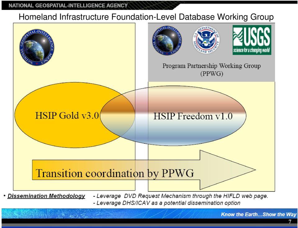
12 Homeland Infrastructure Foundation-Level Database Working Group
13 13
14 CDMS Web Portal and Desktop The standardized role-based application to update statewide HAZUS-MH datasets CDMS Web Portal: FEMA S SOFTWARE PROGRAM FOR UPDATING STATEWIDE DATASETS

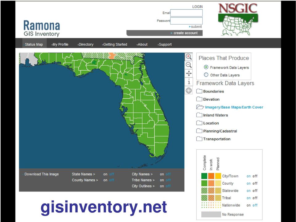
15 gisinventory.net
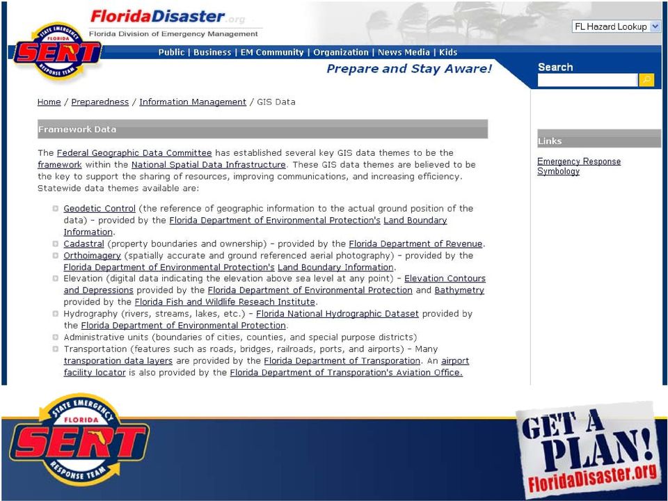
16 16 Geodetic Control Ortho-imagery Elevation Transportation Hydrography Governmental Units Cadastral Information

17 17
18 Resolution 1 arc second 30 meter 1/3 arc second 10 meter 1/9 arc second 3 meter 18

19 2000 FIU s International Hurricane Center Broward 19 Utilization of the airborne LIDAR data resulted in considerable reduction of predicted flood areas, as a first cut without further refinements and upgrading of the SLOSH numerical model. Broward County Emergency Management officials were able to remove 175,000 people from being unnecessarily evacuated in the event of a hurricane.

20 Project Overview Begun FY Complete FY Begun FY Complete FY FY Light Detection and Ranging LiDAR Data Processing Development for SLOSH Sea, Lake, Overland Surge from Hurricanes SLOSH Models Begun FY Complete FY Analyses Vulnerability Behavioral Demographics Transportation Regional Evacuation Studies FY Storm Surge Zones FY 08-09

21 Florida is 54,250 square miles 21 8,600 14,600 1,300 2,200 1,400 Previously Existing Data HB New Data HB Improve Existing Data FEMA - New Data Partnering Agencies - New Data 28,100 total square miles Project Footprint
22
23 23 Compiled from Regional Evacuation Studies undertaken by the Regional Planning Councils -- Storm Surge Zones Evacuation Routes Both currently being updated by RPC s FloridaDisaster.org/gis/data
24 Increasingly, we are turning to the web for direct use of web mapping services and online data sources (WMS and/or KML) 24 National Weather Service (watches and warnings, radar, storm reports) USGS Emergency Operations Hazards Data Distribution System ESRI Imagery and more
25
26 Web Mapping Services
27 27 Florida Adopts the USNG USNG was officially adopted by the FFCA FDEM adopted the USNG in the CEMP Florida Fire College, Florida Fire Chiefs Association, Fl National Guard have developed curriculum and instructor manuals FloridaDisaster.org/gis/usng
28 28 Florida Geographic Data Library Hosts 1,000 meter and 100 meter grids for each Florida county Data is also available via the National Map
29 Questions? 29 FloridaDisaster.org/gis
Minnesota State Plan Review Level 2 Hazus-MH 2.1 County Model for Flooding Dakota County Evaluation
 Overview Minnesota State Plan Review Level 2 Hazus-MH 2.1 County Model for Flooding Dakota County Evaluation Minnesota Homeland Security and Emergency Management (HSEM) is responsible for supporting activities
DIVISION OF EMERGENCY MANAGEMENT
 DIVISION OF EMERGENCY MANAGEMENT PROGRAM DESCRIPTION The Florida Division of Emergency Management (DEM) is responsible for maintaining a comprehensive statewide program of emergency management. In addition,
HAZUS 2014. 7 th Annual Conference
 HAZUS 2014 7 th Annual Conference HAZUS Comparison of Storm Surge Levels from Different Hurricanes to the Newest SLOSH Models for Berkeley, Charleston, & Dorchester Counties Along the SC Coastline. Charlie
Indiana Office of Community and Rural Affairs. Disaster Recovery and Mitigation Planning Ft. Worth, Texas February 15, 2012
 Indiana Office of Community and Rural Affairs Disaster Recovery and Mitigation Planning Ft. Worth, Texas February 15, 2012 Floods Indiana s costliest hazard State ranks 5 th in annual median flood damages
Florida Statewide Regional Evacuation Study Program. Glossary
 Florida Statewide Regional Evacuation Study Program Volume 1-11 South Florida Region Volume 1-11 South Florida Statewide Regional Evacuation Study Program This page intentionally left blank. Statewide
Homeland Security Infrastructure Program HSIP Gold 2012 September 2012
 Homeland Security Infrastructure Program HSIP Gold 2012 September 2012 George Thomas, Chief, Content & Knowledge Management Division (PDC) IWG-Readiness, Response & Recovery (IWG-R3) George.J.Thomass@nga.mil,
CEMP Criteria for Residential Treatment Facilities
 CEMP Criteria for Residential Treatment Facilities Lee County Emergency Management The following minimum criteria are to be used when Comprehensive Emergency Management Plans (CEMP) for all Residential
Emergency Management Planning Criteria For Residential Treatment Facilities
 Emergency Management Planning Criteria For Residential Treatment Facilities The following minimum criteria are to be used for Comprehensive Emergency Management Plans (CEMP) for Therapeutic Group Homes
EMERGENCY MANAGEMENT PLANNING CRITERIA FOR AMBULATORY SURGICAL CENTERS
 EMERGENCY MANAGEMENT PLANNING CRITERIA FOR AMBULATORY SURGICAL CENTERS The following criteria are to be used when developing Comprehensive Emergency Management Plans (CEMP) for all ambulatory surgical
EMERGENCY MANAGEMENT PLANNING CRITERIA FOR HOSPITALS
 EMERGENCY MANAGEMENT PLANNING CRITERIA FOR HOSPITALS The following minimum criteria are to be used when developing Comprehensive Emergency Management Plans (CEMP) for all hospitals. These criteria will
State of North Dakota. GIS Program Strategic Plan 2015-2017
 State of North Dakota GIS Program Strategic Plan 2015-2017 Prepared By: Bob Nutsch GIS Coordinator Information Technology Department Approved By: North Dakota GIS Technical Committee Date of Publication:
MARCH 31, 2010 - WEDNESDAY
 MARCH 31, 2010 - WEDNESDAY GENERAL SESSIONS Buffalo Plane Crash This session will focus on the emergency manager s overview of the Buffalo New York plane crash of Continental 3407. Overview of November
Emergency Management Planning Criteria for Nursing Home Facilities (Criteria)
") Emergency Management Planning Criteria for Nursing Home Facilities (Criteria) The following minimum criteria are to be used when developing Comprehensive Emergency Management Plans (CEMP) for all Nursing
Emergency Management Planning Criteria for Nursing Home Facilities (Criteria) The following minimum criteria are to be used when developing Comprehensive Emergency Management Plans (CEMP) for all Nursing
AMBULATORY SURGICAL CENTERS
 AMBULATORY SURGICAL CENTERS STATUTE RULE CRITERIA Current until changed by State Legislature or AHCA Hospitals and Ambulatory Surgical Centers Statutory Reference 3 395.1055 (1)(c), Florida Statutes Rules
Risk Mitigation Expense or Investment?
 Risk Mitigation Expense or Investment? Jon W. Raleigh, ARM Director of Insurance/Risk Management Irene, Heather Roiter New York City Office of Emergency Management Savita Goel, P.E., LEED AP Whitlock Dalrymple
NURSING HOME STATUE RULE CRITERIA
 NURSING HOME STATUE RULE CRITERIA Page 1 of 11 Nursing Homes Statutory Reference 8 400.23 (2)(g), Florida Statutes Rules; criteria; Nursing Home Advisory Committee; evaluation and rating system; fee for
The Delaware DataMIL A Pilot Project for The National Map. April 18, 2002 Delaware GIS Conference: Connecting Communities
 The Delaware DataMIL A Pilot Project for The National Map April 18, 2002 Delaware GIS Conference: Connecting Communities The DataMIL Team University of Delaware Christina Callahan, Research & Data Management
Data Sharing Best Practices
 Data Sharing Best Practices Louisiana Remote Sensing and GIS Workshop Session 8: Local Government Wednesday, May 13, 2015 Warren Kron, GISP GIS Manager Department of Information Services Outline ebrgis
 Using HAZUS for a Statewide Flood Risk Assessment Steve Cowdin, CA DWR Ken Leep, Cal EMA Problem We frequently receive requests for statewide flood data Who s at risk? What s at risk? Where is at risk?
Where is Risk MAP Now? Update on the Flood Risk Assessment Dataset. Shane Parson RAMPP
 Where is Risk MAP Now? Update on the Flood Risk Assessment Dataset Shane Parson RAMPP Agenda Overview Average Annualized Loss (AAL Study) Risk MAP Flood Risk Assessment Dataset Process AAL Data Refined
Emergency Management Planning Criteria for Ambulatory Surgical Centers (State Criteria Form)
") Emergency Management Planning Criteria for Ambulatory Surgical Centers (State Criteria Form) FACILITY INFORMATION: FACILITY NAME: FIELD (Company) FAC. TYPE: ASC STATE RULE: 59A-5, F.A.C CONTACT PERSON:
Emergency Management Planning Criteria for Ambulatory Surgical Centers (State Criteria Form) FACILITY INFORMATION: FACILITY NAME: FIELD (Company) FAC. TYPE: ASC STATE RULE: 59A-5, F.A.C CONTACT PERSON:
Office of Geospatial Technology Management North Carolina Flood Mapping Program State of North Carolina Business Plan FY 2010 2014
 Office of Geospatial Technology Management North Carolina Flood Mapping Program State of North Carolina Business Plan FY 2010 2014 Executive Summary This Business Plan, prepared by the Geospatial and Technology
EMERGENCY MANAGEMENT PLANNING CRITERIA FOR ADULT DAY CARE FACILITIES
 The following criteria are to be used for the development of Comprehensive Emergency Management Plans (CEMP) for Adult Day Care (ADC). The criteria will serve as a recommended plan format for the CEMP,
*****IMPORTANT SUBMITTAL INFORMATION*****
 The following minimum criteria are to be used when developing Comprehensive Emergency Management Plans (CEMP) for all Nursing Homes. The criteria serve as the required plan format for the CEMP, and will
Earth Data Science in The Era of Big Data and Compute
 Earth Data Science in The Era of Big Data and Compute E. Lynn Usery U.S. Geological Survey usery@usgs.gov http://cegis.usgs.gov U.S. Department of the Interior U.S. Geological Survey Board on Earth Sciences
Emergency Management Planning Criteria for Assisted Living Facilities (State Criteria Form)
") Emergency Management Planning Criteria for Assisted Living Facilities (State Criteria Form) FACILITY INFORMATION: FACILITY NAME: FIELD (ALF Company) ST. LIC. NO.: FIELD (Lic. #) FAC. TYPE: ALF STATE RULE:
Emergency Management Planning Criteria for Assisted Living Facilities (State Criteria Form) FACILITY INFORMATION: FACILITY NAME: FIELD (ALF Company) ST. LIC. NO.: FIELD (Lic. #) FAC. TYPE: ALF STATE RULE:
MD imap 2.0 THE NEXT GENERATION OF MARYLAND S ENTERPRISE GIS. Esri MUG Conference Baltimore, MD December 3, 2014 http://imap.maryland.
 THE NEXT GENERATION OF MARYLAND S ENTERPRISE GIS MD imap 2.0 Matt Sokol, GISP Senior GIS Analyst Maryland Department of Information Technology Geographic Information Office Julia Fischer, GISP Senior GIS
Emergency Management Planning Criteria for Hospital Facilities (State Criteria Form)
") Emergency Management Planning Criteria for Hospital Facilities (State Criteria Form) FACILITY INFORMATION: FACILITY NAME: FIELD (Company) ST. LIC. NO.: FIELD (Lic. #) FAC. TYPE: Hospital STATE RULE: 59A-3.078
Emergency Management Planning Criteria for Hospital Facilities (State Criteria Form) FACILITY INFORMATION: FACILITY NAME: FIELD (Company) ST. LIC. NO.: FIELD (Lic. #) FAC. TYPE: Hospital STATE RULE: 59A-3.078
GIS Initiative: Developing an atmospheric data model for GIS. Olga Wilhelmi (ESIG), Jennifer Boehnert (RAP/ESIG) and Terri Betancourt (RAP)
, Jennifer Boehnert (RAP/ESIG) and Terri Betancourt (RAP)") GIS Initiative: Developing an atmospheric data model for GIS Olga Wilhelmi (ESIG), Jennifer Boehnert (RAP/ESIG) and Terri Betancourt (RAP) Unidata seminar August 30, 2004 Presentation Outline Overview
GIS Initiative: Developing an atmospheric data model for GIS Olga Wilhelmi (ESIG), Jennifer Boehnert (RAP/ESIG) and Terri Betancourt (RAP) Unidata seminar August 30, 2004 Presentation Outline Overview
AMBULATORY SURGICAL CENTERS (Based upon AHCA Form # 3130-2003 JUL 94)
") (Based upon AHCA Form # 3130-2003 JUL 94) The document below is the cross-reference used by Palm Beach County Division of Emergency Management for the annual review and re-certification of your CEMP. Review
(Based upon AHCA Form # 3130-2003 JUL 94) The document below is the cross-reference used by Palm Beach County Division of Emergency Management for the annual review and re-certification of your CEMP. Review
APPENDIX XII: EMERGENCY SUPPORT FUNCTION 12 - ENERGY
 APPENDIX XII: EMERGENCY SUPPORT FUNCTION 12 - ENERGY PRIMARY AGENCIES: Public Service Commission and the Florida Energy and Climate Commission SUPPORT AGENCIES: Nuclear Regulatory Commission, Florida Rural
HOSPITALS STATUTE RULE CRITERIA. Current until changed by State Legislature or AHCA
 HOSPITALS STATUTE RULE CRITERIA Current until changed by State Legislature or AHCA Hospitals and Ambulatory Surgical Centers Statutory Reference' 395.1055 (1)(c), Florida Statutes Rules and Enforcement.
GTM North Carolina Floodplain Mapping Program. RFQ 286-000023 Pre-Submittal Conference
 GTM North Carolina Floodplain Mapping Program RFQ 286-000023 Pre-Submittal Conference State Response / Strategies Strategy 1 - Establishment of a statewide program to acquire, process and disseminate current,
Best Practices for Developing Geographic Information Models
 Urban and Regional Information Systems Association 1460 Renaissance Dr., Suite 305 Park Ridge, IL 60068 (847) 824-6300 Best Practices for Developing URISA Certified Workshop August 2007 Dr. David K. Arctur,
ADULT DAY CARE CENTER
 ADULT DAY CARE CENTER STATUTE RULE CRITERIA Current until changed by State Legislature or AHCA Adult Day Care Centers Statutory Reference 1 400.562, Florida Statutes Rules establishing standards. (1) The
Florida s Public Health and Medical Emergency Response System Emergency Support Function 8
 Florida s Public Health and Medical Emergency Response System Emergency Support Function 8 Tipping Points Built on a Foundation of Partnerships Jean L. Kline, RN, BSN, MPH Deputy Secretary for Health Public
For fiscal year 2006-2007, Governor Jeb Bush is recommending an investment of $565 million of state and federal funding for three priority areas:
 HURRICANE PREPAREDNESS, RESPONSE AND RECOVERY BUSH/JENNINGS BUDGET RECOMMENDATIONS FOR FISCAL YEAR 2006-2007 TO THE FLORIDA LEGISLATURE Florida has experienced unprecedented back-to-back hurricane seasons.
Created by Neevia docuprinter Pro trial version http://www.neevia.com Created by Neevia docuprinter Pro trial version
 GEOGRAPHIC INFORMATION SYSTEMS AND WATER RESOURCES IV AWRA SPRING SPECIALTY CONFERENCE Houston, Texas May 8-10, 2006 Copyright 2006, AWRA HURRICANE KATRINA AND DISASTER RECOVERY GEOSPATIAL PROCESS FOR
HURRICANE DISASTER PREPARATION CHECKLIST AND BUSINESS CONTINUITY PLAN
 HURRICANE DISASTER PREPARATION CHECKLIST AND BUSINESS CONTINUITY PLAN G. Thomas Harper, Esq., Editor Florida Employment Law Letter HARPER GERLACH, PL 4110 Southpoint Boulevard Suite 228 Jacksonville, Florida
SCHOOL RISK MANAGEMENT PLANNING LEVERAGING DATA, TOOLS AND PARTNERSHIPS
 School Facilities Safer School Risk Management Viewer School Risk Management Plan SCHOOL RISK MANAGEMENT PLANNING LEVERAGING DATA, TOOLS AND PARTNERSHIPS December 4, 2013 John Dorman North Carolina Emergency
ART Vulnerability and Risk Assessment Report September 2012 Appendix C. ART GIS Exposure Analysis
 Adapting to Rising Tides GIS Exposure Analysis The aim of this appendix is to familiarize the reader with the data and methodology that was used to conduct an analysis of shoreline and community asset
BROWARD COUNTY RAPID IMPACT ASSESSMENT (RIA) Handbook Course Guide
 Handbook Course Guide") BROWARD COUNTY RAPID IMPACT ASSESSMENT (RIA) Handbook Course Guide Broward County Emergency Management Division (BEMD) August 2009 Table of Contents 1. Introduction -------------------------------------------------
BROWARD COUNTY RAPID IMPACT ASSESSMENT (RIA) Handbook Course Guide Broward County Emergency Management Division (BEMD) August 2009 Table of Contents 1. Introduction -------------------------------------------------
Internship Vacancies
 Internship Vacancies The Florida Division of Emergency Management is pleased to announce the following vacancies for interns. Vacancies are located throughout the State; any upper level, degree-seeking
ArcGIS Framework Plug-In: Extending the ArcGIS Desktop for ANSI Standard Framework Data to Support Government Decision Making
 ArcGIS Framework Plug-In: Extending the ArcGIS Desktop for ANSI Standard Framework Data to Support Government Decision Making Final Project Report October 28, 2008 Agreement Number Organization Project
EMERGENCY MANAGEMENT PLANNING & COMPLIANCE REVIEW CRITERIA FOR NURSING HOMES [FL RULE CHAPTER 59A-4.126 F.A.C]
![EMERGENCY MANAGEMENT PLANNING & COMPLIANCE REVIEW CRITERIA FOR NURSING HOMES [FL RULE CHAPTER 59A-4.126 F.A.C]](/thumbs/33/16547086.jpg "EMERGENCY MANAGEMENT PLANNING & COMPLIANCE REVIEW CRITERIA FOR NURSING HOMES [FL RULE CHAPTER 59A-4.126 F.A.C]") EMERGENCY MANAGEMENT PLANNING & COMPLIANCE REVIEW CRITERIA FOR NURSING HOMES [FL RULE CHAPTER 59A-4.126 F.A.C] Notice: Facilities must submit their plans with the appropriate page numbers shown in the
EMERGENCY MANAGEMENT PLANNING & COMPLIANCE REVIEW CRITERIA FOR NURSING HOMES [FL RULE CHAPTER 59A-4.126 F.A.C] Notice: Facilities must submit their plans with the appropriate page numbers shown in the
TABLE OF CONTENTS 10. ANNEX D... 10-2
 TABLE OF CONTENTS 10. ANNEX D... 10-2 10.1 PURPOSE...10-2 10.2 SITUATION AND ASSUMPTIONS...10-2 10.2.1 SITUATION...10-2 10.2.2 ASSUMPTIONS...10-2 10.3 GENERAL PROCEDURES AND RESPONSIBILITIES... 10-3 10.3.1
Doral Business Start-Up Orientation: Emergency Preparedness & Business Continuity Planning
 Doral Business Start-Up Orientation: Emergency Preparedness & Business Continuity Planning Miami-Dade County s Public-Private Partnership OEM program incorporates the public and private sector in one team
APPENDIX G FLOOD WARNING RESPONSE PLAN
 ESCAMBIA COUNTY, FLORIDA DEPARTMENT OF PUBLIC SAFETY POLICY/PROCEDURE-Division of Emergency Management RE: Flood Warning Response Plan Approved by: Effective Date: August 27, 2007 Revised/Reviewed Date:
Weather: National Hurricane Center South Florida Weather Forecast Office 305-229-4550 Local Time and Temperature 305-324-8811
 Police (Non-Emergencies) North Miami Beach 305-949-5500 Miami-Dade County 305-476-5423 Weather: National Hurricane Center South Florida Weather Forecast Office 305-229-4550 Local Time and Temperature 305-324-8811
Geospatial Software Solutions for the Environment and Natural Resources
 Geospatial Software Solutions for the Environment and Natural Resources Manage and Preserve the Environment and its Natural Resources Our environment and the natural resources it provides play a growing
How To Prepare For A Flood In Hampshire
 Chapter 6. Emergency Services Emergency services measures protect people during and after a flood. Locally, these measures are coordinated by the Huntsville-Madison County Emergency Management Agency.
Flooding Emergency Response Exercise
 Flooding Emergency Response Exercise James Woodward, Senior Exercise Planner California Emergency Management Agency 3650 Schriever Ave. Mather, CA 95655 Cell: (916) 439-3546 Email: james.woodward@calema.ca.gov
Franklin County Emergency Management Department (FCEMD) All County Emergency Response Team (CERT) Agencies. Table of Contents
 All County Emergency Response Team (CERT) Agencies. Table of Contents") Concept of Operations Lead Agency Support Agency Standard Operating Procedures Emergency Operations Center (EOC) Franklin County Emergency Management Department (FCEMD) All County Emergency Response Team
Concept of Operations Lead Agency Support Agency Standard Operating Procedures Emergency Operations Center (EOC) Franklin County Emergency Management Department (FCEMD) All County Emergency Response Team
U.S. Army Corps of Engineers
 Walla Walla District U.S. Army Corps of Engineers Hurricane Katrina Response Briefer: Joseph Saxon Today s Briefing U.S. Army Corps of Engineers Mission Events leading up to New Orleans flooding Corp s
Figure 1. USGS Coastal Change Hazards home page (http://marine.usgs.gov/kb/ views/cch/). This topical node of the USGS Coastal and Marine Knowledge
. This topical node of the USGS Coastal and Marine Knowledge") THE COASTAL CHANGE HAZARDS NODE OF THE U.S. GEOLOGICAL SURVEY (USGS) COASTAL AND MARINE KNOWLEDGE BANK: ONLINE SCIENTIFIC RESOURCES FOR COASTAL ZONE MANAGEMENT AND DISASTER PREPAREDNESS M. Dennis Krohn,
THE COASTAL CHANGE HAZARDS NODE OF THE U.S. GEOLOGICAL SURVEY (USGS) COASTAL AND MARINE KNOWLEDGE BANK: ONLINE SCIENTIFIC RESOURCES FOR COASTAL ZONE MANAGEMENT AND DISASTER PREPAREDNESS M. Dennis Krohn,
Visualize your World. Democratization i of Geographic Data
 Visualize your World Democratization i of Geographic Data Session Agenda Google GEO Solutions - More than just a Map Enabling our Government Customers- Examples Summary & Invite to Learn More About Google
Preparedness in the Southwest
 Preparedness in the Southwest Risk Assessment and Hazard Vulnerability Developed by The Arizona Center for Public Health Preparedness Cover Art www.azcphp.publichealth.arizona.edu Chapter 1 Importance
CROSS-REFERENCE FOR COMPREHENSIVE EMERGENCY MANAGEMENT PLAN RESIDENTIAL TREATMENT CENTERS FOR CHILDREN AND ADOLESCENTS
 CROSS-REFERENCE FOR COMPREHENSIVE EMERGENCY MANAGEMENT PLAN RESIDENTIAL TREATMENT CENTERS FOR CHILDREN AND ADOLESCENTS (Based upon AHCA Criteria dated July 2006) The document below is the cross-reference
DISASTER DISASTER MANAGEMENT CRISIS INFORMATICS GIS IN DIFFEERENT STAGES OF DISASTER MANAGEMENT
 APPLICATION OF GIS AND REMOTE SENSING IN DISASTER PRONE AREAS: A CASE STUDY IN COASTAL KERALA DISASTER Disaster is an unpleasant event than occurs with little or no warning which results in economic disruption,
What is GIS. What is GIS? University of Tsukuba. What do you image of GIS? Copyright(C) ESRI Japan Corporation. All rights reserved.
 ESRI Japan Corporation. All rights reserved.") What is GIS University of Tsukuba Graduate School of Life and Environmental Science April 21 st, 2011 What is GIS? What do you image of GIS? Gas Insulated Switch Groupe Interventional Speciale Geographic
What is GIS University of Tsukuba Graduate School of Life and Environmental Science April 21 st, 2011 What is GIS? What do you image of GIS? Gas Insulated Switch Groupe Interventional Speciale Geographic
Emergency Preparedness Tips and Actions for the Workplace
 Emergency Preparedness Tips and Actions for the Workplace Is Your Business Disaster Ready? Disaster and emergencies can happen anytime and anywhere in Minnesota. 52 Presidential Disaster Declarations between
Volume 1-2 Technical Data Report Apalachee Region CHAPTER IV Regional Population and Vulnerability Analysis
 Volume 1-2 Technical Data Report Apalachee Region CHAPTER IV Regional Population and Vulnerability Analysis APPENDIX IV-H Liberty County Critical Facilities and Vulnerability Analysis Statewide Regional
Utah State General Records Retention Schedule SCHEDULE 1 GEOSPATIAL DATA SETS
 Utah State General Records Retention Schedule SCHEDULE 1 BIOTA RECORDS (Item 1-26) These are geospatial records that depict wildlife use areas in the state of Utah as determined by wildlife biologists
Customer and Data Services (CDS) Hazus Release 3.0. User Release Notes
 Hazus Release 3.0. User Release Notes") Customer and Data Services (CDS) Hazus Release 3.0 User Release Notes Version 0.4 November 13, 2015 Document Management History Revision History Version Number Date Summary of Changes Team/Author 0.1 10/05/15
Customer and Data Services (CDS) Hazus Release 3.0 User Release Notes Version 0.4 November 13, 2015 Document Management History Revision History Version Number Date Summary of Changes Team/Author 0.1 10/05/15
Youth Crime, Restorative Justice, and GIS - Lee County, Florida Authors: Richard Faris, John Bizelli
 Youth Crime, Restorative Justice, and GIS - Lee County, Florida Authors: Richard Faris, John Bizelli Abstract The Lee County Department of Human Services (DHS) is using GIS to analyze underlying geographic
Volume 1-2 Technical Data Report Apalachee Region CHAPTER IV Regional Population and Vulnerability Analysis
 Volume 1-2 Technical Data Report Apalachee Region CHAPTER IV Regional Population and Vulnerability Analysis APPENDIX IV-F Jefferson County Critical Facilities and Vulnerability Analysis Statewide Regional
Emergency Management
 LESSON PLAN 5 Be Disaster Safe Learning that there is a system in place and that agencies cooperate to take care of the community s needs during emergencies and disasters reassures and supports students.
Appendix J Online Questionnaire
 Appendix J Online Questionnaire In accordance with the Paperwork Reduction Act, this questionnaire was approved by the Office of Management and Budget (OMB). The OMB control number and expiration date
Goal 1 To protect the public health, safety and property from the harmful effects of natural disasters.
 Plan Framework for Coastal Management The purpose of this element is to provide for the protection of residents and property in within the coastal area of the host community, and to limit expenditures,
STATE OF FLORIDA DIVISION OF EMERGENCY MANAGEMENT. State Emergency Response Team. October 24, 2006
 STATE OF FLORIDA DIVISION OF EMERGENCY MANAGEMENT State Emergency Response Team JEB BUSH Governor October 24, 2006 W. CRAIG FUGATE Director Dear County Directors, Thank you for attending this session of
The Role of Elected Officials During Disasters. The Florida Division of Emergency Management
 The Role of Elected Officials During Disasters The Florida Division of Emergency Management Bryan W. Koon Director Florida Division of Emergency Management Introduction Florida s elected officials play
Guide to Physical Security Planning & Response
 Guide to Physical Security Planning & Response For Hospitals, Medical & Long Term Care Facilities Includes comprehensive section on evacuation best practices All hazards planning & response Templates Best
Enterprise GIS Business Plan July 4, 2008
 Office for Information Resources GIS Services Enterprise GIS Business Plan July 4, 2008 VERSION 1.1 Table of Contents 1 Executive Summary... 3 2 Background... 6 2.1 Tennessee Base Mapping Program... 6
BUSINESS CONTINUITY PLAN
 BUSINESS CONTINUITY PLAN Business Name: Phone # Cell # Emergency Contact Information: Dial 9-1-1 in an Emergency Non-Emergency: Police: Fire: Insurance Provider: Emergency Planning Team: I. CRITICAL OPERATIONS
Development of an Impervious-Surface Database for the Little Blackwater River Watershed, Dorchester County, Maryland
 Development of an Impervious-Surface Database for the Little Blackwater River Watershed, Dorchester County, Maryland By Lesley E. Milheim, John W. Jones, and Roger A. Barlow Open-File Report 2007 1308
Risk MAP Project Coordination Meeting: Burlington County, NJ. FEMA REGION II May 8, 2013 Westampton, New Jersey
 Risk MAP Project Coordination Meeting: Burlington County, NJ FEMA REGION II May 8, 2013 Westampton, New Jersey Agenda Introductions Purpose of this Meeting Risk MAP Program Overview Anticipated Project
Challenges. Estimated Damages from 100-Year Flood
 Suffield Suffield is a rural community located along the Massachusetts border. It encompasses about 42.2 square miles and has a population of about 15,735. Suffield s terrain rises from an elevation of
GIS Data Models for INSPIRE and ELF
 GIS Data Models for INSPIRE and ELF Paul Hardy Roberto Lucchi EuroSDR/ELF Copenhagen Data Modelling and Model Driven Implementation of Data Distribution 28 Jan 2015 ArcGIS for INSPIRE Extends ArcGIS for
Applying High-resolution Satellite Imagery and Remotely Sensed Data to Local Government Applications
 Applying High-resolution Satellite Imagery and Remotely Sensed Data to Local Government Applications Sioux Falls, South Dakota Presentation Prepared by Steven J. Van Aartsen City of Sioux Falls GIS November
Daily Operations Briefing Sunday, May 24, 2015 8:30 a.m. EDT
 Daily Operations Briefing Sunday, May 24, 2015 8:30 a.m. EDT Significant Activity May 23-24 Significant Events: Flooding Southern Plains Tropical Activity: Atlantic Tropical cyclone activity not expected
Jefferson Parish Department of Water Emergency Plan
 1. Overview Jefferson Parish Department of Water Emergency Plan 1.1. Purpose The purpose of this document is to establish procedures for the Department of Water during natural disasters or terrorist acts.
An Initial Assessment of the Impacts of Sea Level Rise to the California Coast
 An Initial Assessment of the Impacts of Sea Level Rise to the California Coast Photo by D. Revell 2/23/08 California Coastal Records Project Dr. David Revell and Matt Heberger, P.E. Dr. Peter Gleick, Bob
Back Home Again in Indiana
 Back Home Again in Indiana FEMA REGION VI HAZUS LEVEL 2 PILOT Update August 2010 RAMPP (Risk Assessment, Mapping and Planning Partners) James R. Mawby, CFM - Lead Geographer, Dewberry Joseph C. Kirby,
Response and Recovery
 LESSON PLAN 3 Response and Recovery Hurricanes When young people see what individuals and communities can do before, during and after a hurricane, they will begin to understand the importance of people
ESF 14. Long-Term Community Recovery
 1. Purpose This annex provides an overview of the general process to be followed in recovering from the economic results of a natural disaster or other major emergency that may impact Coos County. It outlines
LAND USE PLANNING FOR HAZARD MITIGATION
 LAND USE PLANNING FOR HAZARD MITIGATION Community Report for Johnson County and the Municipalities of Kite and Wrightsville JUNE 2013 ACKNOWLEDGEMENTS PAGE GEORGIA DEPARTMENT OF COMMUNITY AFFAIRS Jim Frederick,
Alluvial Fan Mapping and Risk Assessment
 Alluvial Fan Mapping and Risk Assessment Army Corps of Engineers: Webinar Week 12:30PM (MST) 08.21.2013 Silver Jacket Conference Idaho Department of Water Resources Boise, Idaho Overview PROJECT OVERVIEW
MEMORANDUM TO CLIENT Attorney-Client Privileged
 TO: FROM: Structural Occupancy Category I and II Building Owners Adam Leitman Bailey, P.C. DATE: April 8, 2013 SUBJECT: Changes to NYC Zoning and Building Regulations after Hurricane Sandy Question Presented:
Comprehensive Economic Development Strategy (CEDS) Report 2012-2017. Southwest Florida Economic Development District
 Report 2012-2017. Southwest Florida Economic Development District") Southwest Florida Economic Development District Southwest Florida Economic Development District TABLE OF CONTENTS Strategy Report Executive Summary... v A. Background... 2 Community and Private Sector
Southwest Florida Economic Development District Southwest Florida Economic Development District TABLE OF CONTENTS Strategy Report Executive Summary... v A. Background... 2 Community and Private Sector
Making Geospatial Data Available and Accessible in Jamaica
 Making Geospatial Data Available and Accessible in Jamaica Presented by Cecille Blake, National GIS Coordinator Office of the Prime Minister, National Spatial Data Management Division 9 th UNRCC New York
Post-Sandy Municipal Needs Assessment for Long-Term Recovery and Resiliency Planning EXECUTIVE SUMMARY
 Post-Sandy Municipal Needs Assessment for Long-Term Recovery and Resiliency Planning EXECUTIVE SUMMARY Prepared by Nathaly Agosto Filión, Resiliency Manager for the New Jersey Resiliency Network, a program
An Esri White Paper May 2012 ArcGIS for Emergency Management
 An Esri White Paper May 2012 ArcGIS for Emergency Management Esri, 380 New York St., Redlands, CA 92373-8100 USA TEL 909-793-2853 FAX 909-793-5953 E-MAIL info@esri.com WEB esri.com Copyright 2012 Esri
CHAPTER 7. EMERGENCY SERVICES
 CHAPTER 7. EMERGENCY SERVICES Although better forecasts and warning processes have helped save lives by providing more lead time to evacuate, the tremendous growth of development and human population in
Simple Tabletop Exercise, Interdependency Natural Disaster Scenario Scenario #8 Facilitator s Guide
 Simple Tabletop Exercise, Interdependency Natural Disaster Scenario Scenario #8 Facilitator s Guide Scenario Summary Background: It is March in Zenith City and the residents are experiencing a cold spring.
Maryland Emergency Operations Plan
 Maryland Emergency Operations Plan Purpose The purpose of the Maryland Emergency Operations Plan (EOP) is to outline an approach and designate responsibilities intended to minimize the consequences of
ST. JOHNS COUNTY COMPREHENSIVE EMERGENCY MANAGEMENT PLAN APRIL 2012. Appendix E. Training Program
 ST. JOHNS COUNTY COMPREHENSIVE EMERGENCY MANAGEMENT PLAN APRIL 2012 Appendix E Training Program Appendix E Training - 1 I. PURPOSE St. Johns County Training Appendix To outline a training program that
ROLE OF THE MODELING, MAPPING, AND CONSEQUENCES PRODUCTION CENTER
 ROLE OF THE MODELING, MAPPING, AND CONSEQUENCES PRODUCTION CENTER Russ Wyckoff, P.E., CFM, MMC Modeling Lead, Tulsa District, USACE, Tulsa, Oklahoma, russell.wyckoff@usace.army.mil ABSTRACT: The goal of
Flooding in Brisbane
 Flooding in Brisbane A guide for residents photo provided by Conan Whitehouse Brisbane is a thriving, world-class city, enjoyed by residents and visitors. Like many cities around the world, Brisbane has
Satellite technology delivers dependability for disaster crisis management
 Satellite technology delivers dependability for disaster crisis management communication technology is quickly advancing with new, improved ways to collect and manage the vital information needed before,
ArcGIS Data Models Practical Templates for Implementing GIS Projects
 ArcGIS Data Models Practical Templates for Implementing GIS Projects GIS Database Design According to C.J. Date (1995), database design deals with the logical representation of data in a database. The