October 19, 2011/Calendar No. 14
|
|
|
- Terence Montgomery
- 3 years ago
- Views:
From this document you will learn the answers to the following questions:
Which Avenue is the location of the Special Fourth Avenue Enhanced Commercial District?
What document was used to establish the Special Fourth Avenue Enhanced Commercial District?
What type of use would be allowed in new developments?
Transcription
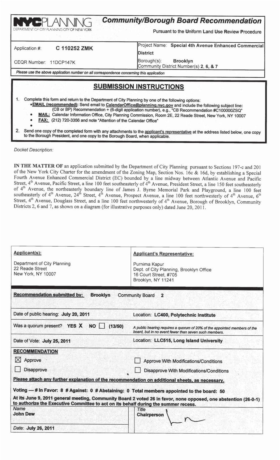
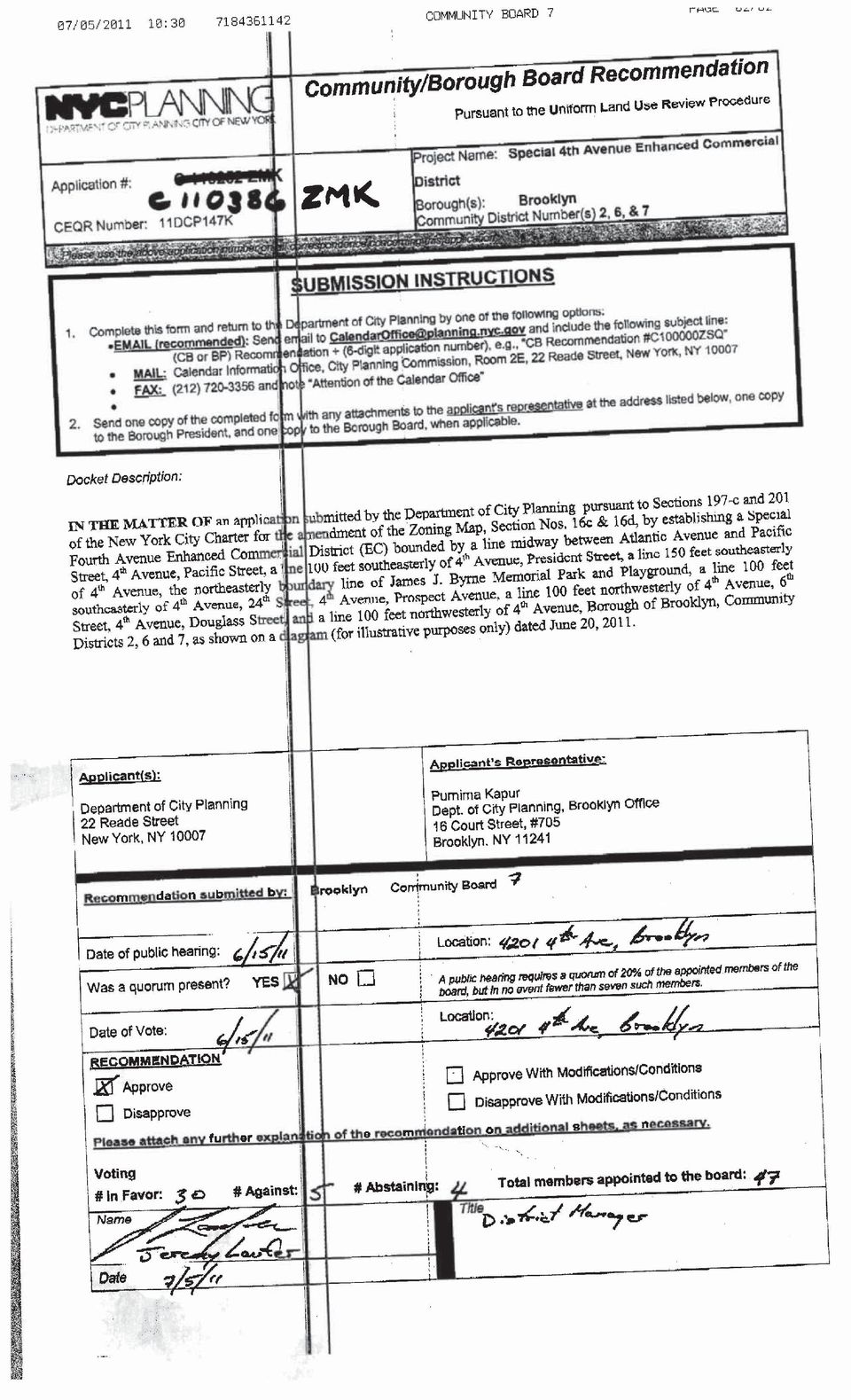
1 CITY PLANNING COMMISSION October 19, 2011/Calendar No. 14 C ZMK IN THE MATTER OF an application submitted by the Department of City Planning pursuant to Sections 197-c and 201 of the New York City Charter for the amendment of the Zoning Map, Section Nos. 16c & 16d, by establishing a Special Fourth Avenue Enhanced Commercial District (EC) bounded by a line midway between Atlantic Avenue and Pacific Street, 4 th Avenue, Pacific Street, a line 100 feet southeasterly of 4 th Avenue, President Street, a line 150 feet southeasterly of 4 th Avenue, the northeasterly boundary line of James J. Byrne Memorial Park and Playground, a line 100 feet southeasterly of 4 th Avenue, 24 th Street, 4 th Avenue, Prospect Avenue, a line 100 feet northwesterly of 4 th Avenue, 6 th Street, 4 th Avenue, Douglass Street, and a line 100 feet northwesterly of 4 th Avenue, Borough of Brooklyn, Community Districts 2, 6, and 7, as shown on a diagram (for illustrative purposes only) dated June 20, This is an application for an amendment of the Zoning Map to establish the Special District EC along 4 th Avenue in Community Districts 2, 6, and 7 in Brooklyn. RELATED ACTIONS In addition to this application (C ZMK) for an amendment of the Zoning Map, which is the subject of this report, the proposal also requires action by the City Planning Commission on the following application which is being considered concurrently with this application: N ZRK: Zoning text change to establish the Special Fourth Avenue Enhanced Commercial District on 56 blocks along Fourth Avenue in the Park Slope and South Park Slope neighborhoods of Brooklyn. BACKGROUND The proposed special district would be located on Fourth Avenue, between Atlantic Avenue and 24 th Street, in the Park Slope and South Park Slope neighborhoods in Brooklyn Community Districts 2, 6 and 7. The proposal would establish special use regulations on the ground floor to limit residential and parking uses while allowing a mix of commercial and community facility uses in new developments and ground floor level enlargements, would create transparency requirements, and would establish limitations on curb cuts.
 bounded by a line midway between Atlantic Avenue and Pacific Street, 4 th Avenue, Pacific Street, a line 100 feet")
2 The portions of Fourth Avenue to which these regulations would apply have been rezoned to R8A and R8A/C2-4 in recent years to encourage mid-density mixed use development with ground floor commercial uses. The proposed Special District is intended to ensure that this trend of mixed uses along the Fourth Avenue corridor would continue. Fourth Avenue is a 120-foot wide arterial road that traverses the Park Slope and South Park Slope neighborhoods. It is lined with three- to twelve-story residential buildings, many of which contain local retail and community facility uses at the ground floor, as well as auto-oriented commercial and light industrial buildings. The neighborhoods of Park Slope and South Park Slope are primarily residential, with a rowhouse context on the side streets, and larger multifamily apartment buildings on the avenues. Fifth and Seventh avenues are neighborhood commercial corridors, with ground-floor retail spaces below two to five floors of apartments above. More recently, since the Park Slope and South Park Slope rezonings in 2003 and 2005, respectively, the character of this portion of Fourth Avenue has slowly been transitioning to a more residential character, with higher-density apartment buildings up to 12 stories in height beginning to line the avenue alongside associated retail and service uses. Fourth Avenue has begun a visible and dramatic evolution from an autooriented, heavy commercial and industrial avenue, to one with significant residential development and a new residential population. While many of the newly-constructed residential buildings contain retail and community facility uses on the ground floors that help activate the sidewalks for pedestrians, some of these buildings contain parking garages with blank walls at the ground floors that do not enliven the pedestrian streetscape. The area of the proposed special district is zoned R8A and R8A/C2-4. The proposed Special District would not change the underlying zoning districts. The blocks zoned R8A/C2-4 along Fourth Avenue between Atlantic Avenue and Warren Street were rezoned in 1993 as part of the Department s Park Slope North contextual rezoning (C ZMK, adopted by the City Council 4/1/1993). Just to the north of the proposed special district on the north side of Atlantic Avenue lies the Special Downtown Brooklyn District, mapped in 2004 to guide growth in this central business district. In 2003, the Department contextually rezoned approximately 110 blocks of Park Slope, including rezoning 39 blockfronts on Fourth Avenue from R6 to R8A and 2 C ZMK

3 R8A/C2-4 (C A ZMK, adopted by the City Council 4/30/2003). The Department followed up this rezoning with its 2005 South Park Slope contextual rezoning, which applied an R8A and R8A/C2-4 zoning district with the Inclusionary Housing program along 12 blockfronts on Fourth Avenue (C ZMK, adopted by the City Council 11/16/2005). The proposed Special Fourth Avenue Enhanced Commercial District is intended to ensure a lively pedestrian context by imposing transparency requirements, limiting curb cuts and establishing special use provisions to require ground-floor neighborhood services and amenities and limiting parking and residential uses on the ground floor facing Fourth Avenue to better serve the growing residential population. The proposed changes would apply to new developments and ground floor level enlargements along 56 blockfronts of Fourth Avenue zoned R8A/C2-4 or R8A in the Park Slope and South Park Slope neighborhoods. Three major components to this text amendment seek to address specific issues that would result in diverse mixed-use developments with commercial, community facility and retail in this emerging new neighborhood. Enlivening uses - To ensure a mix of commercial and retail uses as already permitted by the underlying zoning, the proposal contains Special Use Provisions that would require the entire ground floor be developed or enlarged with permitted non-residential uses, except where residential lobbies and off-street parking facilities are permitted. Of the ground floor frontage of a zoning lot, at least 50% must be occupied by streetscape enlivening commercial uses to a minimum depth of 30 feet. The remaining frontage of the lot (but not more than 50%) may be occupied by any use permitted in the C2-4 zoning district as well as lobby spaces and parking entrances, where applicable. This flexibility in permitting a range of uses would encourage the development of a varied streetscape with active ground-floor uses. Required and permitted parking would continue to be allowed on the ground floors but would be limited to beyond the first 30 feet of the building, or elsewhere in the building. Residential lobbies would be limited to a width of 25 feet to ensure that the maximum feasible ground floor space be occupied by active uses that serve the neighborhood and its new residents. 3 C ZMK

4 Sidewalk continuity- Curb cuts serving new buildings would generally be limited to the side streets. This would ensure pedestrian safety and allow minimize the disruption to the pedestrian experience. Streetscape design - To ensure an interactive and social space along Fourth Avenue, new retail and commercial establishments would be required to adhere to a minimum level of streetwall transparency. Shops and offices with glass storefronts would allow pedestrians to look in and break down barriers between the sidewalk and activities inside. Zoning Text Amendment (N ZRK) The proposed zoning text amendment would create the Special Fourth Avenue Enhanced Commercial District in the Zoning Resolution and would provide regulations pertaining to ground floor use, streetscape design elements, and location of parking entrances. The proposed area to which the Special Fourth Avenue Enhanced Commercial District text would apply encompasses 56 blockfronts on Fourth Avenue between Atlantic Avenue and 24th Street in Brooklyn Community Districts 2, 6, and 7. Special Use Provisions The entire Fourth Avenue ground floor must be occupied by non-residential uses, except that residential lobbies and off-street parking facilities may be permitted (limitations are listed below). A minimum of 50 percent of the ground-floor frontage of a lot fronting on Fourth Avenue to minimum depth of 30 feet must be occupied by a retail use listed in Use Groups 5, 6A, 6C (excluding banks and loan offices), 7B, 8A, 8B or 9A. The remaining portion of the ground floor may be occupied by all non-residential uses permitted in the C2-4 district, residential lobbies and where permitted, entrances to accessory parking facilities. 4 C ZMK
 The proposed zoning text amendment would create the Special Fourth Avenue Enhanced Commercial District in the Zoning Resolution and would provide regulations")
5 All lobbies for upper floor uses shall not exceed 25 feet in width. Entrances and associated curb cuts to accessory and public parking shall only be permitted on Fourth Avenue if it serves an interior zoning lot which does not have access to a side street and has a lot width along Fourth Avenue greater than 60 feet. Transparency/glazing is required for 50 percent of the area between a height of 2 feet and 12 feet as measured from the sidewalk level for all uses fronting on Fourth Avenue, including residential lobbies, but excluding entrances to accessory parking facilities (garage doors), where permitted. No portion of a ground floor may have a blank wall with a width exceeding 10 feet. Unenclosed sidewalk cafes would be permitted in the Special District; enclosed sidewalk cafes would not be permitted. Exceptions to the Special District Provisions: Existing buildings changing uses or doing minor alterations would not be subject to the use or transparency provisions. Buildings used exclusively for schools or houses of worship would be exempt from the use and transparency regulations applicable to the Special District. These provisions would not be applicable to existing lots measuring less than 20 feet. Lots in R8A zoning districts would not be subject to the minimum glazing and use restrictions but would have to comply with the proposed curb cut rules listed above. Zoning Map Amendment (C ZMK): The proposed Special Fourth Avenue Enhanced Commercial District text amendment would be shown on the zoning map by mapping a Special District denoted EC (Enhanced Commercial). 5 C ZMK

6 This Special District follows the existing zoning line for the R8A and R8A/C2-4 zoning district that is mapped along this portion of 4th Avenue. The Special Fourth Avenue Special District is bounded by midblock between Atlantic Avenue and Pacific Street to the north (immediately adjacent to the Special Downtown Brooklyn District) and to 24th Street to the south. The area is generally 100 feet in depth along Fourth Avenue, with the exception of five blocks between President and 3rd Streets where it is 150 feet deep. The area is zoned R8A/C2-4 overlay with the exception of four blocks which are within an R8Adistrict. The proposed Special District would not change the underlying zoning. ENVIRONMENTAL REVIEW This application (C ZMK), in conjunction with the application for the related actions (N ZRK) was reviewed pursuant to the New York State Environmental Quality Review Act (SEQRA), and the SEQRA regulations set forth in Volume 6 of the New York Code of Rules and Regulations, Section et seq. and the City Environmental Quality Review (CEQR) Rules of Procedure of 1991 and Executive Order No. 91 of The designated CEQR number is 11DCP147K. The lead is the City Planning Commission. After a study of the potential environmental impact of the proposed action (C ZMK), a Negative Declaration was issued on June 20, The lead agency has determined that the proposed action will have no significant effect on the quality of the environment UNIFORM LAND USE REVIEW This application (C ZMK) in conjunction with the applications for the related non- ULURP applications (N ZRK) was duly referred to Brooklyn Community Boards 2,6, and 7, and the Brooklyn Borough President on June 22, 2011 in accordance with the procedure for referring non-ulurp matters in conjunction with the related actions (N ZRK) which were certified as complete by the Department of City Planning on June 22, 2011 in accordance with Title 62 of the Rules of the City of New York, Section 2-02(b). 6 C ZMK

7 Community Board Public Hearing Community Board 2 held a public hearing on July 20, 2011 on this application (N ZRK) and on July 25, The Executive Committee, acting on behalf of the full board as authorized by a vote of 26 in favor with one abstention at the June 9, 2011 general meeting, by vote of 8 in favor, 0 opposed, and no abstentions, adopted a resolution recommending approval of the application. Community Board 6 held a public hearing on June 23, 2011 on this application (N ZRK) on July 14, 2011, by vote of 13 in favor, 0 opposed, and no abstentions, the Executive Committee adopted a resolution recommending approval of the application with the following conditions: 1. That the Department take a closer look at how restrictions might be placed upon the size of individual commercial stores that can be constructed as-of-right to provide the community with greater control over the possibility for the concentration of big box stores along the corridor; 2. That the department study the affect of rezoning within the Fourth Avenue corridor [that] for the purpose of applying inclusionary housing for affordable housing while continuing to cap building heights at a 120-foot ceiling [sic]. Community Board 7 held a public hearing on June 16, 2011 on this application (N ZMK) and June 16, 2011, by vote of 30 in favor, 5 opposed, and 4 abstentions adopted a resolution recommending approval of the application without conditions. Borough Board Review The Brooklyn Borough Board did not submit a recommendation. 7 C ZMK
 on July 14, 2011, by vote of 13 in favor, 0 opposed, and no abstentions, the Executive Committee adopted a")
8 Borough President Recommendation This application was considered by the Borough President, who held a public hearing on July 27, 2011, and issued a recommendation on August 22, 2011 approving the application with the following conditions: 1. That for the Special Ground Floor Use Requirements for Commercial Districts according to the proposed Zoning Resolution Section (a) mandatory commercial uses for a portion of the ground floor level, be modified to contain additional excluded uses from Use Group 8A: trade schools, business schools; and, medical dental labs. 2. That for the Special Ground Floor Transparency Requirements according to the proposed Zoning Resolution Section , that for show windows sill height, in lieu of allowing a height of four feet above curb level applicable to general transparencies, such windows shall be not more than two feet six inches (2-6 ) above curb level (as per the special downtown Brooklyn District (ZR ). In addition, the Borough President further resolved that: 1. That the Department of City Planning should undertake a zoning analysis for the purposes of enlarging the R8A district for the blocks frontages along the west side of Fourth between Douglass to 6 th Streets and south of the Prospect Expressway to 24 th Street; 2. That the Department of City Planning should undertake an analysis for a zoning text amendment to make applicable the Inclusionary Housing Program s affordable housing floor area incentives for the section for the R8A district north of That the Department of City Planning should undertake an analysis of the R8A district s parking requirement on Brooklyn for the purposes of minimizing the applicability of when a development might be permitted to reduce the parking requirement for smaller zoning lots and/or waive parking otherwise required; th Street; 8 C ZMK

9 4. The City to analyze and implement means to provide streetscaping/landscaping along Fourth Avenue, including through subway gate upgrades and Builder Pavement Plans for all new developments; and 5. That the Department of City Planning should consult with Brooklyn s community boards and local elected officials to solicit interest in having mandatory ground floor retail use frontage requirements pursuant to the Special Enhanced Commercial District regulations alonf specified retail streets where there is potential for redevelopment based on the zoning s corresponding residential density and then proceed with zoning actions to establish such districts at the urging for the affected community board. City Planning Commission Public Hearing On September 7, 2011 (Calendar No. 1), the City Planning Commission scheduled September 21, 2011, for a public hearing on this application (C ZMK). The hearing was duly held on September 21, 2011 (Calendar No. 5), in conjunction with the hearing on the related action (N ZRK). There were three speakers in favor of the proposal and none opposed. The Council Member representing the 39 th District spoke in support of the proposal, emphasizing the importance of opportunities to activate the streetscape embodied in the proposal. The Council Member requested that the City Planning Commission consider amending the proposal to further restrict medical and dental labs in the new special district, and also lower the height of the required transparency for 4 th Avenue frontages. In addition, the Council Member expressed support for rezoning blocks fronting on 4 th Avenue currently zoned for manufacturing use with R8A/C2-4 zoning districts and expanding the Enhanced Commercial District and Inclusionary Housing Area to include these areas as well. A representative of the Brooklyn Borough President spoke in favor of the proposal, and expressed the Borough President s strong support of the proposal as part of his overall vision for 4 th Avenue, and the importance of encouraging retail use in this area. He reiterated the Borough President s conditions from his recommendation that seek to further restrict trade schools, business schools, and medical/dental labs, as well as lowering the level of required transparency 9 C ZMK

10 on 4 th Avenue to better engage the pedestrian. He said that the Borough President also supports extending the R8A/C2-4 zoning along 4 th Avenue in the manufacturing districts, and would like to see Inclusionary Housing Regulations in place for the full corridor. The District Manager for Brooklyn Community District 6 spoke in favor of the proposal, and stated that the proposal was not considered controversial in the community. He also encouraged the Department of City Planning to study establishing Inclusionary Housing regulations on 4 th Avenue in CD 6. There were no other speakers and the hearing was closed. CONSIDERATION The Commission believes that the proposed amendment to the zoning map, and related action (N ZRK), as modified, are appropriate. The Commission acknowledges that some of the buildings developed on Fourth Avenue under the current zoning have parking garages with blank walls fronting on the street, which disrupts the retail continuity and affects the pedestrian streetscape. The proposed Special Fourth Avenue Enhanced Commercial District would establish regulations to encourage ground retail floor uses on Fourth Avenue, ground-floor transparency, and relocate parking entrances off the retail corridor. The proposed changes would apply to new developments and ground floor level enlargements along 56 blockfronts of Fourth Avenue zoned R8A/C2-4 or R8A in the Park Slope and South Park Slope neighborhoods of Brooklyn and does not modify or expand the underlying zoning regulations. The Commission believes that the proposed Special Fourth Avenue Enhanced Commercial District would assist the emerging residential and commercial corridor along Fourth Avenue to develop streetscape character that is safe and engaging for pedestrians and provide for the needs of the growing residential population on Fourth Avenue and the surrounding area. 10 C ZMK

11 The Commission notes that the Fourth Avenue corridor is an emerging commercial corridor, with many properties yet to be developed, and that ground-floor commercial spaces may be occupied by a variety of businesses over time as the area matures as a retail location. The Commission believes that the proposed use regulations allow for necessary flexibility as the corridor evolves, and constitute a balanced approach that encourages active use without unduly restricting development in the area. The Commission recognizes the need to promote streetscape continuity on Fourth Avenue. To ensure that cars do not overshadow the pedestrian experience, curb cuts serving new buildings are proposed to be limited to the side streets. The commission believes that this regulation would allow the avenue to develop and evolve at a human-scale, with minimal interruptions to the sidewalk and streetwall. Properties fronting on Fourth Avenue at least 60 feet wide, without access to a side street, would be allowed to construct a curb cut on Fourth Avenue, recognizing that parking is required and desirable in this area. The Commission recognizes the importance of promoting an interactive and social space along Fourth Avenue. The proposal would require new retail and commercial establishments to provide to a minimum level of streetwall transparency. Shops and offices with glass storefronts allow pedestrians to look in, which breaks down barriers between the sidewalk and activities inside. For lots fronting on Fourth Avenue, 50% of the area between a height of 2 and 12 feet would be required to be transparent. The Commission notes that the proposal as certified further stipulated that transparent areas provided to satisfy this requirement must begin no higher than four feet above curb level. The Commission agrees with the Borough President and local Council Member that windows provided at a height of 4 feet would not engage the attention of the pedestrian as directly as those at a lower height. The Commission hereby modifies the proposed zoning text amendment to require that transparent areas provided to satisfy the minimum transparency requirement begin at a height no higher than two feet, six inches above curb level. The Commission believes this 11 C ZMK

12 modification will result in a livelier streetscape that engages the pedestrian, fostering a safer, more pleasant experience on Fourth Avenue. Community Board 6 requested that the Commission further limit the size and location of businesses on Fourth Avenue, however this would be outside the scope of the action. Community Board 6, along with the Borough President and local Council Member, also requested that Inclusionary Housing regulations be extended to Fourth Avenue above 15 th Street. This would also be outside the scope of this action. The Commission recognizes the requests of the Borough President and Council Member from District 39 that the retail and service uses proposed to satisfy the 50% frontage requirement be further limited. However, these changes would be outside the scope of this action. Therefore, the proposal, as modified, is approved. The Commission believes that proposed special district would establish regulations to encourage enlivening uses, retail continuity, and façade elements that engage the pedestrians, RESOLUTION RESOLVED, that the City Planning Commission finds that the action described herein will have no significant impact on the environment; And be it further RESOLVED, by the City Planning Commission, pursuant to Sections 197-c and 200 of the New York City Charter, that based on the environmental determination and consideration described in this report, the Zoning Resolution of the City of New York, effective as of December 15, 1961, and as subsequently amended, is further amended by changing the Zoning Map, Section Nos. 16c & 16d, by establishing a Special Fourth Avenue Enhanced Commercial District (EC) bounded by a line midway between Atlantic Avenue and Pacific Street, 4 th Avenue, Pacific Street, a line 100 feet southeasterly of 4 th Avenue, President Street, a line 150 feet southeasterly of 4 th Avenue, the northeasterly boundary line of James J. Byrne Memorial Park and Playground, 12 C ZMK

13 a line 100 feet southeasterly of 4 th Avenue, 24 th Street, 4 th Avenue, Prospect Avenue, a line 100 feet northwesterly of 4 th Avenue, 6 th Street, 4 th Avenue, Douglass Street, and a line 100 feet northwesterly of 4 th Avenue; Borough of Brooklyn, Community Districts 2, 6, and 7, as shown on a diagram (for illustrative purposes only) dated June 20, The above resolution (C ZMK), duly adopted by the City Planning Commission on October 19, 2011 (Calendar No. 14), is filed with the Office of the Speaker, City Council and the Brooklyn Borough President, pursuant to Section 197-d of the New York City Charter. AMANDA M. BURDEN, FAICP, Chair RICHARD W. EADDY, Vice Chairman ANGELA M. BATTAGLIA, RAYANN BESSER, IRWIN G. CANTOR, P.E., ALFRED C. CERULLO, III, BETTY Y. CHEN, MARIA M. DEL TORO, NATHAN LEVENTHAL, ANNA HAYES LEVIN, ORLANDO MARIN, SHIRLEY A. MCRAE, KAREN A. PHILLIPS, Commissioners 13 C ZMK
, is filed with the Office of the Speaker, City Council and the Brooklyn Borough President, pursuant to Section 197-d of the New York City Charter. AMANDA M. BURDEN, FAICP, Chair RICHARD W.")
14

15
16

17

18

19
20 Brooklyn Borough President Recommendation CITY PLANNING COMMISSION 22 Reade Street, New York, NY FAX # (212) INSTRUCTIONS 1. Return this completed form with any attachments to the Calendar Information Office, City Planning Commission, Room 2E at the above address. 2. Send one copy with any attachments to the applicant s representatives as indicated on the Notice of Certification. APPLICATION #: ZMK ZRK Special 4 th Avenue Enhanced Commercial District In the matter of an application submitted by the Department of City Planning pursuant to Sections c and 201 of the New York City Charter for the amendment of the Zoning Map by establishing a Special 4 th Avenue Enhanced Commercial District (EC) bounded by a line midway between Atlantic Avenue and Pacific Street, 4 th Avenue, Pacific Street, a line 100 feet southeasterly of 4 th Avenue, President Street, a line 150 feet southeasterly of 4 th Avenue, the northeasterly boundary line of James J. Byrne Memorial Park and Playground, a line 100 feet southeasterly of 4 th Avenue, 24 th Street, 4 th Avenue, Prospect Avenue, a line 100 feet northwesterly of 4 th Avenue, 6 th Street, 4 th Avenue, Douglass Street, and a line 100 feet northwesterly of 4 th Avenue. This would facilitate ground floor retail use along Fourth Avenue for new developments. COMMUNITY DISTRICT NO. 2, 6, 7 BOROUGH OF BROOKLYN RECOMMENDATION APPROVE APPROVE WITH MODIFICATIONS/CONDITIONS DISAPPROVE DISAPPROVE WITH MODIFICATIONS/CONDITIONS August 22, 2011 BOROUGH PRESIDENT DATE

21 RECOMMENDATION FOR THE PROPOSED ZONING MAP AMENDMENT AND TEXT AMENDMENT FOR FOURTH AVENUE ZMK ZRK PUBLIC HEARING On July 27, 2011 the Borough President held a public hearing on the proposed actions. A representative from the Department of City Planning (DCP) detailed the main points of the application and there were no speakers for or against the plan. As part of the hearing, it was noted that DCP practice has been to only make the Inclusionary Housing Program (IHP) district applicable in conjunction with an upzoning. The necessity for increased density along Fourth Avenue, by DCP standards, is not prevalent therefore incorporating the IHP has not been considered. Community Boards 2, 7 voted to approve these applications, while Community Board 6 approved while noting that if the R8A district were to be enlarged, it should include the IHP. Subsequent to the hearing, the Borough President announced the formation of a task force aimed at the transformation of Fourth Avenue that will oversee planning of project specifics, including tree planting and use of a newly expanded Times Plaza at the intersection of 4 th, Atlantic, and Flatbush Avenues. CONSIDERATION At the 2011 State of the Borough Address (SOTB), the Borough President promoted his vision for a transformation of Fourth Avenue into a livable, walk-able, tree-lined avenue. He seeks to turn Fourth Avenue s plain brick facades, speckled with ventilation exhaust grates of enclosed parking, into a grand avenue spanning from the Atlantic Ocean to Atlantic Avenue dubbed as Brooklyn Boulevard. Subsequent to the SOTB Address, in a letter to DCP, he called for an amendment to the zoning that would require retail as part of the ground floor of any new buildings along Fourth Avenue a change he believes will create a positive streetscape experience for pedestrians. DCP has created a response that largely addresses existing deficiencies of the Zoning Resolution by proposing the Special Fourth Avenue Enhanced Commercial District. The goal is to turn Fourth Avenue into a lively mixed-use neighborhood with a vibrant mix of commercial and community facilities on the ground floor of all new developments. With these applications, the Borough President commends DCP for agreeing with his vision and creating a proposal that will prevent future developments from adding to the avenue s unattractive corridor of blank masonry walls. The Borough President generally supports the proposal though does believe that it could be enhanced by further modifying the uses to be excluded and with more specificity regarding the transparency controls as part of the adopted proposal. In addition, the Borough President is seeking further enhancement of Brooklyn Boulevard by: providing more opportunities to promote residential development; making applicable inclusionary housing; modifying parking requirements; and, incorporating additional streetscape/landscape enhancements. He also believes that the Special Commercial Enhancement Regulations should be incorporated in other retail corridors throughout Brooklyn. All of the above are described further below. PAGE 2
22 APPROPRIATE USE The Borough President shares DCP s belief that the mandatory retail frontage (50 percent of the total frontage) should exclude certain uses that, by their nature, are not conducive to creating engaging retail, commercial or community facility use along the Fourth Avenue corridor. DCP s proposal would exclude such uses as banks, loan offices, offices, public service establishments, motels, small wholesale establishments, auto related stores such as glass, seat covers and tire sales, auto rental establishments, public parking and wholesale hair products. Such uses would otherwise be permitted in the remaining balance of the frontage that is not utilized for residential lobbies or accessory parking. In addition to the excluded uses proposed by DCP, the Borough President believes that it is appropriate to exclude from the mandatory commercial frontage the following uses from Use Group 8A: trade schools; business schools; and, medical dental labs, that he believes are not lively or engaging uses or necessarily pedestrian friendly. Such uses support retail corridors best when often situated above the ground floor as their staff and student body might patronize nearby retailers. TRANSPARENCY Transparency standards provide opportunities for pedestrians to look inside at merchandise and activity in a manner that makes a more interesting experience when strolling along a retail corridor. Interesting corridors often result in more foot-traffic that support retailers while providing more eyes on the street as a means to enhance a feeling of being safe in the neighborhood. This is further enhanced when lighting from stores augment the City s street lights. DCP proposes that transparency must start not less than four feet above the sidewalk within the proposed regulated zone. The Borough President believes that the minimum level of streetscape transparency proposed by DCP could be further improved by providing additional standards that govern the maximum height of show window sills between the proposed regulated zone of between two and twelve feet above the sidewalk. Without such a control, development might meet the 50 percent transparency requirement by providing much of the glazing above eye level. The Borough President notes that the Special Downtown Brooklyn District contains a requirement for the show sill height not to exceed two feet six inches above the sidewalk level. He believes that such a control is appropriate to incorporate into this zoning proposal in order to ensure that a sufficient portion of the transparency is below eye level, thus enabling pedestrians to see more of what is inside the retail space. ALLOWING RESIDENTIAL ALONG MORE OF BROOKLYN BOULEVARD In his 2003 recommendation for the rezoning of Park Slope, the Borough President noted that despite already being predominately residential, block frontages along the west side of Fourth Avenue (between Douglass and Sixth streets) were not included in the proposed rezoning. Other blocks contain sites occupied by one-story uses similar to those that DCP identified as likely to be converted to housing. Similarly, as part of the 2005 recommendation for the South Park Slope Rezoning, the Borough President noted that the block fronts along the west side of Fourth Avenue south of the Prospect Expressway contained a wide range of uses, including residential. PAGE 3
23 As part of DCP s May 2008 draft zoning proposal for the Gowanus Canal Corridor, the analytical framework depicted the frontages between Douglas and First streets for residential development by suggesting the zoning be R8A with a C2 commercial overlay ( In order for this section of Fourth Avenue to truly become a grand residential boulevard, the Borough President believes DCP should analyze these additional areas along Fourth Avenue (west side of Fourth Avenue between Douglas to 6 th streets and south of the Prospect Expressway to 24 th Street) to determine the appropriateness of enlarging the R8A district for the potential to provide more opportunities to facilitate housing. INCLUSIONARY HOUSING It is the Borough President s firm belief that developers should provide housing for those who are being priced out of Brooklyn, especially vulnerable populations such as seniors. He believes that plans to grow the residential housing stock of a neighborhood are deficient when they do not increase or preserve the supply of affordable housing. The Borough President has consistently stated his interest in having the section of Fourth Avenue north of 15 th Street be incentivized through zoning to produce affordable housing. In the Borough President s consideration of the 2003 rezoning of Park Slope which included the section of Fourth Avenue in Community District 6, he noted that it was appropriate to provide affordable housing through incentives linked to a zoning text amendment as a means to achieve the inclusion of units affordable to the median income of area residents. Subsequently as part of the rezonings for West Chelsea, the Hudson Yards and the Williamsburg-Greenpoint waterfront neighborhoods in 2005, the City established an expanded version of its Inclusionary Housing Program (IHP) zoning incentive. In May 2006, as part of the Borough President s recommendation regarding the establishment of the IHP to R7-3 zoning district, he called for DCP to advance additional amendments to such districts as R8A and its commercial equivalent districts. In his transmittal letter he referenced Park Slope as a neighborhood worthy of consideration. And in May 2009, as part of the Brooklyn Borough Board s Resolution distribution letter commenting on revisions to the IHP, he recommended that areas previously rezoned to encourage the production of housing that are not included in the IHP should be amended to incorporate this zoning incentive. One such area referenced was Fourth Avenue in Community District 6. In consideration of the city s response for being reluctant to retroactively reduce as-of-right floor area, the Borough President believes that a shift in City policy is warranted. Most sites along Fourth Avenue experienced a doubling in residential development rights, from 3.0 floor area ratio (FAR) to 6.0 FAR, though some of the northern most blocks increased from 4.0 FAR to 6.0 FAR. In essence, the upzoning provided the opportunity for substantial financial gain when selling or redeveloping properties. If the City would be receptive to modifying the R8A to R8A with the IHP, the base FAR, while dropping to 5.4 FAR, is still substantially greater than what it was prior to rezoning. It is likely that many of the properties have not changed hands since the original zoning, therefore the City should not be viewing a change from R8A to R8A with IHP the same as a traditional downzoning. In addition, by utilizing the IHP, twenty percent of the floor area derived from the bonus can be used for market rate development, yielding a sum of 5.76 FAR as compared to the 6.0 existing today, a negligible reduction. Meanwhile, with 7.2 FAR achievable, the results would increase the supply of permanent affordable housing while having an almost identical outcome of market-rate units. The City should view such an approach as in its best interest. PAGE 4
24 The Borough President believes that DCP should undertake a zoning text amendment to make applicable the affordable housing floor area incentives for the section of the R8A district north of 15 th Street. PARKING REQUIREMENTS As part of his 2005 recommendation report regarding the South Park Slope rezoning, the Borough President expressed concerns that the R8A zoning required too little parking for car ownership patterns in that part of Brooklyn. The South Park Slope area seemed to already be experiencing, on occasion, a deficit of on-street parking spaces. Therefore, the Borough President called on DCP to initiate a zoning text amendment for R8A districts in Community District 7 that would amend the parking requirement as a percent of the number of units and to modify the waiver of otherwise required parking. Requiring more parking takes into consideration those residents that prefer car ownership for work and recreational means due to its convenience in light of inadequate public transportation. This requirement also recognizes the difficulty faced by such residents in terms of finding convenient onstreet parking, a demand that s on the rise due to many recent developments since the upzonings went into effect. Too often new developments contain the minimum on-site parking standards despite what might be the possible car ownership rates of the new building occupants. Thus, the adequacy of the available on-street parking continues to be further compromised, making it more difficult for longtime residents with cars. These neighborhoods have few monthly-based public parking opportunities. While primarily a resource for residents of new high-rise residential buildings, such parking facilities may also accommodate neighbors seeking secured off-street parking. The Borough President had expressed such concerns on multiple occasions, including letters to DCP from June 2008 and September 2009 when DCP initiated increased requirements for the Rockaways; and then again for the Special Long Island City District. Collectively, these changes increased the probability that new developments in Long Island City will provide an adequate amount of parking to accommodate the new residents. While he applauded DCP for taking those steps to address community concerns in Long Island City and in the Rockaways, he believed it appropriate to introduce these concepts in warranted areas of Brooklyn. Changes consistent to what was done in those communities make sense to be applied to certain upzoned areas in Brooklyn. Addressing the reality of automobile ownership in the City should be part of DCP s agenda. Requiring more parking recognizes the need to respect the quality-of-life for households where public transit does not provide for a sufficient range of journeys. The proposed Special Fourth Avenue Enhanced Commercial District would prohibit curb cuts along Fourth Avenue frontage for lots with not more than 60 feet of frontage. Therefore the Borough President believes that parking requirements might warrant a reduction in the waiver from 15 to five to be more consistent with such lot sizes. Without such reductions, for lots greater than 15,000 sf, up to 38 market-rate units might be developed without a requirement to provide parking. For lots between 10,001 and 15,000 sf, up to 77 units might be provided without parking. If the waiver was reduced to five, as was done for Long Island City, 14 units would instead be required to provide parking for the larger lots and 28 units would trigger the requirement for parking for the mid-size lots. PAGE 5
25 Therefore, the Borough President believes that DCP should analyze a zoning text amendment for the Fourth Avenue R8A district that amends the parking requirement for lots between 10,001 square feet (sf) and 15,000 sf to no longer be permitted to be meeting the reduced requirement of 20 percent of the units to have parking; with the size of lots exempt from parking being reduced from 10,000 sf to 6,000 sf and the waiver being reduced from 15 spaces to 5 spaces. STREETSCAPE/LANDSCAPE Fourth Avenue has been defined by its absence of trees and landscaping along the traffic median and sidewalks of this wide corridor. While the zoning changes that increased residential density has brought several new buildings, it has not improved the streetscape. The Special Enhanced Commercial District regulations is expected to help bring about the retail vibrancy as a means to improve the streetscape though that in itself is merely a component of what needs to be a comprehensive set of actions. Landscaping has contributed to the beauty of a large number of grand boulevards in this city. Ocean, Eastern, Pelham and Mosholu Parkways, as well as Park Avenue, Broadway and the Grand Concourse all exhibit qualities of properly landscaped thoroughfares. Ocean and Eastern Parkways are most special due to both the mandated large setbacks and the planted malls separating the roadways. Mosholu Parkway has a wide greenway separating the roadways. Both Park Avenue and Broadway have landscaped malls, despite being right over subway trenches. The Grand Concourse, while having a nominal width front yard, has shrubs and hedges lining the apartment buildings. These streets clearly provide an example for what can be achieved on Fourth Avenue. The Borough President is working with stakeholders and elected officials to achieve these ends through the creation of a Fourth Avenue Task Force charged with the long term planning of Fourth Avenue with the goal of realizing such transformation. It should be City policy to have Fourth Avenue transformed into a special roadway such as these other proud streets. To truly evolve into Brooklyn Boulevard, the center traffic median should be treated in a manner consistent with Park Avenue and Broadway uptown. Within the public right-of-way, the Fourth Avenue median should be treated in a manner consistent with Park Avenue and upper Broadway in Manhattan or Ocean and Eastern Parkways in Brooklyn. Subway grates should be upgraded with sculptural elements that may also incorporate landscaping. Many examples already exist within the MTA s system of subway vents that have been altered to incorporate sculptural elements that maintain the infrastructural needs of the system while contributing to the streetscape. The subway vents on Fourth Avenue should be treated in the same manner. Additionally, the City should pursue the planting of sidewalk trees for the entire length of Fourth Avenue from Flatbush Avenue to Shore Road. The combination of sculptured subway vents with landscaping in front of buildings and street trees along the avenue will go a long way towards transforming the streetscape and complementing DCP s text amendment. These measures could be regulated through prescribed standards as part of the review of Builders Pavement Plans. Already the Department of Environmental Protection s (DEP) NYC Green Infrastructure initiative is playing a role through its coordination with the Department of Design and Construction and the Department of Transportation with construction projects in the street right-of-ways. DEP intends to PAGE 6
26 see that bioswales be incorporated, to function as storm-water diverters, into the traffic calming implementation projects at three locations along Fourth Avenue during the Fall of This will be one of many positive steps towards achieving Brooklyn Boulevard. As such, the Borough President urges the City to analyze and implement means to provide streetscaping/landscaping along Fourth Avenue for all new developments. Establishing Additional Special Enhanced Commercial Districts The Borough President believes that there are many other commercial streets that would benefit from being regulated by the Special Enhanced Commercial District regulations. Certain retail streets contain residential density that might tempt developers or property owners to redevelop sites that are substantially under-built pursuant to the underlying zoning district. As noted in the Borough President s 2005 rezoning of the Homecrest section of Brooklyn, he had recommended that DCP should draft a zoning text change to require retail frontage along Kings Highway prior to the redevelopment of any of the properties. He had believed that the proposed rezoning of Kings Highway between Coney Island Avenue and Ocean Avenue increased the incentive to develop housing. That section of Kings Highway is a major retail center and provides an essential service to area residents. The Borough President was concerned that neither the existing nor proposed zoning district requires retail use at the ground floor. The Borough President expressed concern that certain developers were less experienced with development of mixed-retail/residential development and that without requirements to mandate retail use for the ground floor developers might opt to construct entirely residential condominium developments. The Borough President believes that any loss of retail frontage along such streets as Kings Highway could be detrimental for the entire corridor. While Fourth Avenue is not an established retail corridor it has demonstrated that developers make choices that are not always in the best interest of the public realm. Since the rezoning of Homecrest, the Borough President noted that the entirety of the retail districts in Staten Island mandate retail frontage. In addition, when DCP established the R7D and its C4-5D commercial equivalent, which was mapped along Fulton Street in the Bedford-Stuyvesant section of Brooklyn, such districts have mandatory retail frontages. The Borough President believes it is more than appropriate to establish mandatory retail along several retail corridors in Brooklyn as a means to remove the theoretical threat of elimination and to introduce the urban design enhancements. In addition to the Homestead section of Kings Highway, there are several other worthy retail corridors that merit consideration. These include such streets such as: 86 th street in both Bensonhurst and Bay Ridge; Brighton Beach Avenue; and, one or more sections of Broadway such as where it borders Bedford- Stuyvesant and Bushwick as potential examples. The Borough President believes that DCP should consult with Brooklyn s community boards and local elected officials to solicit interest in having mandatory retail frontage along specified retail streets where there is potential for redevelopment based on the zoning s corresponding residential density and then proceed with zoning actions to establish such districts at the urging of the affected community board. PAGE 7
27 RECOMMENDATION Be it resolved that the Borough President of Brooklyn, pursuant to section 197-c of the New York City Charter, recommends that the City Planning Commission and City Council approve these zoning amendments pursuant to the following conditions: 1. That for the Special Ground Floor Level Use Requirements for Commercial Districts according to the proposed Zoning Resolution Section (a) mandatory commercial uses for a portion of the ground floor level, be modified to contain additional excluded uses from Use Group 8A: trade schools; business schools; and, medical dental labs. 2. That for the Special Ground Floor Level Transparency Requirements according to the proposed Zoning Resolution Section , that for show windows sill height, in lieu of allowing a height of four feet above curb level applicable to general transparencies, such windows shall be not more than two feet six inches (2-6 ) above curb level (as per the special downtown Brooklyn District (ZR ). Be it Further Resolved 1. That the Department of City Planning should undertake a zoning analysis for the purposes of enlarging the R8A district for the blocks frontages along west side of Fourth between Douglass to 6 th streets and south of the Prospect Expressway to 24 th Street; 2. That the Department of City Planning should undertake an analysis for a zoning text amendment to make applicable the Inclusionary Housing Program s affordable housing floor area incentives for the section of the R8A district north of 15 th Street; 3. That the Department of City Planning should undertake a analysis of the R8A district s parking requirement in Brooklyn for the purposes of minimizing the applicability of when a development might be permitted to reduce the parking requirement for smaller zoning lots and/or waive parking otherwise required; 4. The City to analyze and implement means to provide streetscaping/landscaping along Fourth Avenue, including through subway grate upgrades and Builder Pavement Plans for all new developments; and, 5. That the Department of City Planning should consult with Brooklyn s community boards and local elected officials to solicit interest in having mandatory ground floor retail use frontage requirements pursuant to the Special Enhanced Commercial District regulations along specified retail streets where there is potential for redevelopment based on the zoning s corresponding residential density and then proceed with zoning actions to establish such districts at the urging of the affected community board. PAGE 8
A zoning map amendment to change an M3-1 district to an R7-3 district with a C2-4 overlay.
 CITY PLANNING COMMISSION March 8, 2010/ Calendar No. 4 N 100056 ZRK IN THE MATTER OF an application submitted by Rose Plaza on the River LLC, pursuant to Section 201 of the New York City Charter, for an
WHEREAS, on December 20, 2012, Metro Storage NY, LLC submitted an application
 CITY PLANNING COMMISSION April 24, 2013/Calendar No. 7 M 840631(B) ZMK IN THE MATTER OF an application submitted by Metro Storage NY, LLC for modification to Restrictive Declaration D-100 pursuant to Section
CITY PLANNING COMMISSION February 19, 2014/Calendar No. 10
 CITY PLANNING COMMISSION February 19, 2014/Calendar No. 10 C 140069 ZSM IN THE MATTER OF an application submitted by Goldman Properties pursuant to Sections 197-c and 201 of the New York City Charter for
CITY PLANNING COMMISSION. February 18, 2015/Calendar No. 15
 CITY PLANNING COMMISSION February 18, 2015/Calendar No. 15 N 140142 ZAM IN THE MATTER OF an application submitted by Workspace, Inc. for the grant of an authorization pursuant to Section 42-142 of the
CITY PLANNING COMMISSION January 21, 2015/Calendar No. 15
 CITY PLANNING COMMISSION January 21, 2015/Calendar No. 15 N 150189 PXM IN THE MATTER OF a Notice of Intent to acquire office space submitted by the Department of Citywide Administrative Services, pursuant
COMPREHENSIVE CITY PLANNING CALENDAR of The City of New York CITY PLANNING COMMISSION WEDNESDAY, JULY 13, 2016
 COMPREHENSIVE CITY PLANNING CALENDAR of The City of New York CITY PLANNING COMMISSION WEDNESDAY, JULY 13, 2016 MEETING AT 10:00A.M. AT SPECTOR HALL 22 READE STREET NEW YORK, NEW YORK Bill de Blasio, Mayor
CITY PLANNING COMMISSION February 18, 2015/ Calendar No. 7
 CITY PLANNING COMMISSION February 18, 2015/ Calendar No. 7 C150153HUX IN THE MATTER OF an application submitted by the Department of Housing Preservation and Development (HPD) pursuant to Section 505 of
Presentation: Proposed Plan Amendments
 Epstein s Rehabilitation Plan Presentation: Proposed Plan Amendments MORRISTOWN REDEVELOPMENT ENTITY March 14, 2013 Epstein s Rehabilitation Plan Presentation Part 1: Morristown Planning Division Neighborhood
Downtown Core Sub-district
 3-10 Land Use Downtown Core Sub-district District development will be most intense and most urban in character in the Downtown Core. The objective is to establish this area as a citywide and regional retail
 Walkable Communities Florida Department of Transportation State Safety Office Pedestrian and Bicycle Program April 1995 www.dot.state.fl.us/safety Twelve Steps for an Effective Program Page 1 Twelve Steps
Topic 2 11/28/2012 Blocks & Street Network
 TOPIC 2 Blocks & Street Network Implementation Note: 1. Some recommendations are summarized in the tables herein. For complete recommendation language, please see the. 2. Recommendations referenced in
BEACON AVENUE URBAN RENEWAL PROJECT
 BEACON AVENUE URBAN RENEWAL PROJECT City of Jersey City Adopted May, 1976 Block and Lot Updates August 6, 2012 Amended September 13, 2012 DIVISION OF CITY PLANNING Beacon Avenue Urban Renewal Project Table
S U S TA I N A B L E C O M M U N I T I E S : EAST NEW YORK
 S U S TA I N A B L E C O M M U N I T I E S : EAST NEW YORK REGIONAL ACCESS MIDTOWN 30 40 mins (A) LOWER MANHATTAN 18 25 mins (A) JAMAICA 9 Mins (LIRR) NASSAU CENTER 32 mins (LIRR) DOWNTOWN BROOKLYN 15-20
CITY COUNCIL PACKET MEMORANDUM
 CITY COUNCIL PACKET MEMORANDUM DOCUMENT: Final Plan and Final Plat SUBJECT: City Center Lenexa The Domain at City Center CONTACT PERSON: Beccy Yocham, Director of Community Development DATE: December 3,
B. Improve the appearance and character of areas surrounding new development.
 Chapter 4.3: Landscape Regulations Sections: 4.301 Purposes 4.302 Applicability 4.303 General Provisions 4.304 Landscape Maintenance 4.301 Purposes The purposes of these regulations are to: A. Promote
City Code of ANN ARBOR, MICHIGAN Chapter 55 Zoning
 ARTICLE II. USE REGULATIONS 5:10.2. R1A, R1B, R1C, R1D single family dwelling district (1) Intent. (a) These single family residential districts are designed to provide an environment of predominantly
Downtown Community Planning Council Meeting offebruary 18, 2015
 - san diego Item #12 DATE ISSUED: ATTENTION: SUBJECT: February 13, 2015 Downtown Community Planning Council Meeting offebruary 18, 2015 Consideration of Support for Grant Applications for the San Diego
BASSETT CREEK VALLEY MASTER PLAN OPEN HOUSE
 BASSETT CREEK VALLEY MASTER PLAN OPEN HOUSE February 23, 2006 PROJECT INTRODUCTION Project Area 230 acres $50 million estimated market value (approximately) 50 acres parkland 100 residences (estimated)
D3 April 8, 2015 Public Hearing
 D3 April 8, 2015 Public Hearing APPLICANT AND PROPERTY OWNER: ASSEMBLY OF YAH, INC. STAFF PLANNER: Kevin Kemp REQUEST: Conditional Use Permit (Religious Facility - church) ADDRESS / DESCRIPTION: 5151 Locke
Appendix N: Bicycle Parking Ordinance
 Appendix N: Bicycle Parking Ordinance ORDINANCE NO. #1-13. AN ORDINANCE AMENDING CHAPTER 40 OF THE MUNICIPAL CODE OF THE CITY OF DAVIS TO ADD ARTICLE 40.25A ESTABLISHING BICYCLE PARKING STANDARDS WHEREAS,
Zoning Guide* Contents. Section I Introduction page 2. Section II Residence Districts page 3. Section III Commercial Districts page 5
 Zoning Guide* *The following explanations are provided for CITI users who want basic information about the types of land uses allowed by the city in a given zoning district. If you require more complete
Attachment B Policy Audit Template
 Attachment B Policy Audit Template 5 6 7 8 9 0 Provide A Variety of Transportation Choices Provide A Variety of Transportation Choices Provide A Variety of Transportation Choices Encourage transit-oriented
CITY OF WEST PALM BEACH ZONING BOARD OF APPEALS Meeting Date: February 6, 2014 Zoning Board of Appeals Case No. 3302
 CITY OF WEST PALM BEACH ZONING BOARD OF APPEALS Meeting Date: February 6, 2014 Zoning Board of Appeals Case No. 3302 1950 Golden Lakes Blvd. Class B Special Use Permit Location Aerial I. REQUEST Site is
VISION, DESIGN PRINCIPLES & OVERALL PLANNING STRATEGY
 3 VISION, DESIGN PRINCIPLES & OVERALL PLANNING STRATEGY The overall planning strategy for the Bank Street CDP is to ensure that future development is undertaken in a coordinated and planned approach, supported
BLOCK 400 PLANNED COMMUNITY DISTRICT
 BLOCK 400 PLANNED COMMUNITY DISTRICT Newport Center December 1983 Newport Beach, California Ordinance 88-119 Adopted December 12, 1988 Amendment No. 672 Resolution No. 95-115 Adopted October 9, 1995 Amendment
Application Package for License for Sidewalk Dining Adjacent to Eating Establishment
 Application Package for License for Sidewalk Dining Adjacent to Eating Establishment Community & Economic Development Department Planning Division T :: 831.648.3190 F :: 831.648.3184 www.ci.pg.ca.us/cedd
Near West Side Comprehensive Plan Executive Summary (Revised) April 2004 City of Milwaukee DCD
 April 2004 City of Milwaukee DCD") Near West Side Comprehensive Plan Executive Summary (Revised) April 2004 City of Milwaukee DCD Boundaries The Near West Side Comprehensive Plan covers a broad area immediately west of Milwaukee s downtown.
Near West Side Comprehensive Plan Executive Summary (Revised) April 2004 City of Milwaukee DCD Boundaries The Near West Side Comprehensive Plan covers a broad area immediately west of Milwaukee s downtown.
FILE NO.: Z-8403. LOCATION: Located on the Northeast and Southeast corners of West 12 th Street and Dennison Street
 FILE NO.: Z-8403 NAME: Glason Short-form POD LOCATION: Located on the Northeast and Southeast corners of West 12 th Street and Dennison Street DEVELOPER: Dennis Glason c/o the Law Office of Simmons S.
Los Angeles Union Station, CA Sustainable Neighborhood Assessment. April 22-23, 2014
 Los Angeles Union Station, CA Sustainable Neighborhood Assessment April 22-23, 2014 Sustainable Neighborhood Assessment Through the Sustainable Neighborhood Assessment Tool developed by Global future development
Executive Director s Recommendation Commission Meeting: March 5, 2015
 Executive Director s Recommendation Commission Meeting: March 5, 2015 PROJECT Curseen-Morris Processing and Distribution Center Parking Lot 900 Brentwood Avenue NE Washington, DC SUBMITTED BY United States
COUNTY OF ALBEMARLE PLANNING STAFF REPORT SUMMARY. Staff: Claudette Grant
 COUNTY OF ALBEMARLE PLANNING STAFF REPORT SUMMARY Project Name: ZMA 2013-00004 Hollymead Town Center Block VI Planning Commission Public Hearing: July 29, 2014 Staff: Claudette Grant Board of Supervisors
Revere Beach Transit-Oriented Development Parcels Revere, Massachusetts. Design and Development Guidelines. Part Two.
 Revere Beach Transit-Oriented Development Parcels Revere, Massachusetts Design and Development Guidelines Request for Qualifications and Expressions of Interest with Preliminary Development Plans Part
Industrial Suburban District Regulations City of St. Petersburg City Code Chapter 16, Land Development Regulations
 16.20.110 - Industrial Suburban District ( IS ) Figure REFERENCE Typical Buildings in the IS District Figure REFERENCE Site Plan of a typical development in the IS District Sections: 16.20.110.1 Composition
METROPOLITAN REDEVELOPMENT PLAN II OLD ALBUQUERQUE HIGH SCHOOL
 METROPOLITAN REDEVELOPMENT PLAN II OLD ALBUQUERQUE HIGH SCHOOL Preface This revised plan for redevelopment of the Old Albuquerque High School Metropolitan Redevelopment Area has been prepared pursuant
Citizen Advisory Group Meeting #1 December 8, 2011 6:00 p.m.
 Citizen Advisory Group Meeting #1 December 8, 2011 6:00 p.m. Meeting Agenda 1. Background Information 2. Policy Framework 3. Plan Development Process 4. Public Input Results 5. Vision Statement 6. Group
STAFF REPORT. December 20, 2004. North District Community Council. Director of Community Planning - North
 STAFF REPORT December 20, 2004 To: From: Subject: North District Community Council Director of Community Planning - North Preliminary Report Respecting Revised Application OPA & Rezoning Application 01
d. Building permits may only be approved if consistent with the approved development plan and land division for all units with common walls.
 Section 20.920.060 Tier 2 Infill Standards. In addition to the Tier 1 standards and incentives, Tier 2 infill parcels and land divisions and the subsequent development on those Tier 2 infill parcels shall
INTRODUCTION TO ZONING DISTRICT REGULATIONS
 INTRODUCTION TO ZONING DISTRICT REGULATIONS Classification of Zoning Districts Zoning districts in Dorchester County are categorized as Suburban Urban, Suburban Transition, or Rural. These districts are
ASSESSMENT OF LANDCAPE PROVISIONS FOR PROPOSED PLAN CHANGE 1. Inner Business Zone. Outer Business Zone PALMERSTON NORTH CITY COUNCIL
 A division of Hudson Group Ltd ASSESSMENT OF LANDCAPE PROVISIONS FOR PROPOSED PLAN CHANGE 1 Inner Business Zone Outer Business Zone PALMERSTON NORTH CITY COUNCIL 1 2 A division of Hudson Group Ltd Prepared
Alewife Working Group June 14, 2016
 Alewife Working Group June 14, 2016 cambridgema.gov/citywideplan 1 Agenda What we ve heard Past plans and studies for Alewife Alewife Revitalization Plan (1979) Citywide Plan (1997-2000) Concord-Alewife
REPORT OF THE PLANNING AND DEVELOPMENT DEPARTMENT FOR APPLICATION FOR REZONING ORDINANCE 2015-0183 TO PLANNED UNIT DEVELOPMENT APRIL 9, 2015
 AWH REPORT OF THE PLANNING AND DEVELOPMENT DEPARTMENT FOR APPLICATION FOR REZONING ORDINANCE 2015-0183 TO PLANNED UNIT DEVELOPMENT APRIL 9, 2015 The Planning and Development Department hereby forwards
28.0 Development Permit Area #2 (Neighbourhood District)
") 28.0 Development Permit Area #2 (Neighbourhood District) Goals and Objectives To provide a guide for infill and new development in the Neighbourhood District. To outline the nature, form and character
28.0 Development Permit Area #2 (Neighbourhood District) Goals and Objectives To provide a guide for infill and new development in the Neighbourhood District. To outline the nature, form and character
Appendix C Related Studies
 Appendix C Related Studies Intermodal Transit Village Concept Plan Appendix C Related Studies This appendix summarizes studies that are current at the time of this Plan. Intermodal Transit Village Concept
Division 51-4.400. Yard, Lot, and Space Regulations.
 Division 51-4.400. Yard, Lot, and Space Regulations. SEC. 51-4.401. MINIMUM FRONT YARD. (a) General provisions. (1) Required front yards must be open and unobstructed except for fences. Except as otherwise
Fast Track A Successful Redevelopment: The Palm Beach Outlets Story
 Fast Track A Successful Redevelopment: The Palm Beach Outlets Story SPEAKERS Rick Greene, AICP City of West Palm Beach Brian Seymour, Esq. Gunster Ken Tuma, PE UDKS Josh Long, AICP Gunster Grand Opening
1161.01 CONFORMITY WITH PLANS; DRAINAGE.
 CHAPTER 1161 Subdivision Requirements 1161.01 Conformity with plans; drainage 1161.07 Easements 1161.02 Trees 1161.08 Streets 1161.03 Subdivision name 1161.09 Blocks 1161.04 Street names 1161.10 Lots 1161.05
Technical Memorandum: Land Use Study
 2. Development Density The Lower East Side covers a large area, and so it is reasonable that it represents more than a third of all buildable surface area in the study area (Table 1). Looking at existing
Land Use Element. Introduction 2.3. A Citywide Land Use Policies 2.3. A-1 The Future Land Use Map & the Location of Zones 2.3. A-2 Uses 2.
 Seattle s Comprehensive Plan Toward a Sustainable Seattle 2.1 Land Use Element Table of Contents Introduction 2.3 A Citywide Land Use Policies 2.3 A-1 The Future Land Use Map & the Location of Zones 2.3
HOME BUSINESS APPLICATION GUIDELINES
 HOME BUSINESS APPLICATION GUIDELINES INTRODUCTION Issaquah Highlands Community Association (IHCA) Use Restrictions and Rules (URRs), define the roles of a trade or business and define Home Office Districts
AREA: 2.37 acres NUMBER OF LOTS: 1 FT. NEW STREET: 0 LF. Single-family, Non-conforming machine shop
 FILE NO.: Z-8958 NAME: Rock Structure Repair Short-form PID LOCATION: Located at 8024 Stanton Road DEVELOPER: Rock Structure Repair Attn. Rudy Gutierrez 3 Kipling Court Little Rock, AR 72209 ENGINEER:
FUTURE LAND USE ELEMENT
 GOALS, OBJECTIVES AND POLICIES FUTURE LAND USE ELEMENT GOAL A THE CITY OF FORT WALTON BEACH WILL PLAN FOR AND PROVIDE A HIGH QUALITY OF LIFE TO MEET THE NEEDS OF THE CURRENT AND FUTURE POPULATION, PROVIDING
6.13.2 PERMITTED USES: Within the MS-1 Medical Services District the following uses are permitted: 6.13.2.1 Apothecaries, drug stores, and pharmacies;
 6.13 - MS-1 MEDICAL SERVICES DISTRICT 6.13.1 INTENT: This district is intended to provide space for the harmonious development of medical facilities, services, and related support uses. The Medical Services
Corridor Goals and Objectives
 Corridor Goals and Objectives This chapter presents the goals and objectives, developed by the Corridor Study Committee, that serve as the purpose and intent of the Corridor Plan. This plan covers a twenty
1. Land Use. Chapter 1: Land Use 1-1 Adopted 10/2/09 Amended 3/22/11, 8/16/11
 1. Land Use Minneapolis will develop and maintain a land use pattern that strengthens the vitality, quality and urban character of its downtown core, commercial corridors, industrial areas, and neighborhoods
FILE NO.: Z-6915-C. Gamble Road Short-form PCD and Land Alteration Variance Request
 FILE NO.: Z-6915-C NAME: Gamble Road Short-form PCD and Land Alteration Variance Request LOCATION: Located on the Northwest corner of Chenal Parkway and Gamble Road DEVELOPER: Davis Properties P.O. Box
Envision Venice Strategic Plan for Fiscal Year Ending. September 30, 2016. Preserving and Enhancing the Venice Quality of Life.
 Adopted April 28, 2015 October 1, 2015 through September 30, 2016 Envision Venice Strategic Plan for Fiscal Year Ending September 30, 2016 Preserving and Enhancing the Venice Quality of Life Table of Contents
Opal Service District Plan
 8 The Opal Service District includes a variety of planned land uses including commercial, mixed-use, flex office, industrial, and hospitality. This Plan seeks to simplify the land use categories to allow
Schenk-Atwood Neighborhood Business District Master Plan
 Schenk-Atwood Neighborhood Business District Master Plan Prepared for the Schenk-Atwood Revitalization Association (SARA) and the City of Madison SCHREIBER/ANDERSON ASSOCIATES, INC. BEST Real Estate Group,
Smart Growth Illustrated: Developer s Guidebook. City of Bentonville Community Development Department October 2006
 Smart Growth Illustrated: Developer s Guidebook City of Bentonville Community Development Department October 2006 1 Table of Contents What is Smart Growth...3 Six Goals of Smart Growth 5 Ten Tools of Smart
PLANNING DIVISION STAFF REPORT February 23, 2015. Summary. Background Information PREPARED FOR THE PLAN COMMISSION. Legistar File ID # 36810
 PLANNING DIVISION STAFF REPORT PREPARED FOR THE PLAN COMMISSION Project Address: Application Type: Legistar File ID # 36810 Prepared By: Summary Conditional Use Timothy M. Parks, Planning Division Report
DIVISION STREET CORRIDOR STRATEGY Arlington, Texas May 17, 2012
 DIVISION STREET CORRIDOR STRATEGY Arlington, Texas May 17, 2012 Project Review: DCAC Meeting #2 March 8, 2012 Reviewed stakeholder meetings Online survey findings Market Assessment Macro Market Factors,
01/31/13 ACHIEVING THE VISION FOR RESTON. Reston Master Plan Special Study Task Force
 ACHIEVING THE VISION FOR RESTON Reston Master Plan Special Study Task Force The Reston Master Plan Special Study Task Force was appointed by Hunter Mill District Supervisor Catherine Hudgins to review
City of Valdosta Land Development Regulations. Table of Contents
 TITLE 1 ADMINISTRATION Chapter 102 General Provisions 102-1 Title 102-2 Purpose 102-3 Authority 102-4 Jurisdiction 102-5 Application of Ordinance 102-6 Relationship to Existing Ordinances 102-7 Powers
Cherokee County: Bells Ferry LCI Study & County Ordinance Audit. Prepared by Atlanta Regional Commission Staff 2006. Atlanta Regional Commission
 Cherokee County: Bells Ferry LCI Study & County Ordinance Audit Prepared by Atlanta Regional Commission Staff 2006 Atlanta Regional Commission 1 Document Review and Recommendations Introduction The objective
Kirkland Zoning Code 113.25
 Kirkland Zoning Code 113.25 Chapter 113 COTTAGE, CARRIAGE AND TWO/THREE-UNIT HOMES Sections: 113.05 User Guide 113.10 Voluntary Provisions and Intent 113.15 Housing Types Defined 113.20 Applicable Use
Block A-24 REDEVELOPMENT PLAN
 Block A-24 REDEVELOPMENT PLAN TABLE OF CONTENTS I. Introduction II. Description of Project Area A. Existing Uses and Conditions B. Boundary Description III. Goals and Objectives IV. Redevelopment Activities
The Lancaster Medical District Master Plan. The Lancaster Campus District 1
 The Lancaster Medical District Master Plan The Lancaster Campus District 1 Table of Contents 1 INTRODUCTION 3 2 THE PLANNING PROCESS 4 Assumptions 6 3 PLANNING CONTEXT AND ECONOMIC OUTLOOK 7 Site Analysis
HARRIS TEETER AT LADY S ISLAND CITY OF BEAUFORT DRB CONCEPTUAL PROJECT NARRATIVE Submittal Date: September 2, 2015 Meeting Date: September 10, 2015
 HARRIS TEETER AT LADY S ISLAND CITY OF BEAUFORT DRB CONCEPTUAL PROJECT NARRATIVE Submittal Date: September 2, 2015 Meeting Date: September 10, 2015 PROPOSED REDEVELOPMENT The project consists of demolishing
TOWN OF CARY CONDITIONAL USE ZONING PERMIT. 412 Rutherglen Cary, NC 27511-6437. 412 Rutherglen Cary, NC 27511-6437
 TOWN OF CARY CONDITIONAL USE ZONING PERMIT PETITION: PETITIONER(S): OWNER(S): LOCATION: 01-REZ-16 204 N. Dixon Avenue, Cary, NC PARCEL IDENTIFICATION: 076418218784 REALID: 0031004 AREA: APPROVED ZONING:
WESTFIELD-WASHINGTON ADVISORY PLAN COMMISSION December 7, 2015 1512-SPP-24 & 1512-ODP-24
 Petition Number: Subject Site Address: Petitioner: Request: East side of Oak Road, north of 151 st Street Langston Development Co. Primary Plat and Overall Development Plan amendment review for Mapleridge
ARTICLE VIII SECTION 8.1 O-I OFFICE INSTITUTIONAL DISTRICT
 ARTICLE VIII SECTION 8.1 O-I OFFICE INSTITUTIONAL DISTRICT 8.1.1. O-I DISTRICT SCOPE AND INTENT. Regulations in this section are the O-I district regulations. Article XIX should be consulted to determine
P u b l i c. Development Proposal And Rezoning
 P u b l i c O p e n H o Dvelopment u s e Manhattan Drive Request Development Proposal And Rezoning Argus Properties and CTQ Consultants welcome public input on this proposed development project located
TYPES OF PROPERTIES ARE INCLUDED WITHIN THE T3 TRANSECT DESIGNATION?
 WHAT TYPES OF PROPERTIES ARE INCLUDED WITHIN THE T3 TRANSECT DESIGNATION? The T3 Transect designation under Miami 21 is equivalent to the single-family and duplex residential categories that exist in today
PROFFER STATEMENT REZONING TLZM 2013-0001 LEEGATE November 1, 2013
 PROFFER STATEMENT REZONING TLZM 2013-0001 LEEGATE November 1, 2013 Leegate LLC and Stanley Martin Companies, LLC, owner and applicant, (the Applicant ) of certain property described as Loudoun County Tax
VILLAGE OF RIDGEWOOD ORDINANCE NO. 3491
 VILLAGE OF RIDGEWOOD ORDINANCE NO. 3491 AN ORDINANCE OF THE VILLAGE OF RIDGEWOOD CHANGING THE ZONE CLASSIFICATION OF CERTAIN PROPERTIES FROM THE C ZONE DISTRICT TO A NEW C-R ZONE DISTRICT AND ADOPTING
Day Care and Zoning Regulations in Florida
 AGENDA PLANNING AND ZONING BOARD JANUARY 8, 2014 6:15 P.M. LOCATION: TOWN HALL, 202 EAST MAIN STREET, DUNDEE, FLORIDA CALL TO ORDER: PLEDGE OF ALLEGIANCE: ROLL CALL: TAB 1: APPROVAL OF MINUTES: A. APPROVAL
FOR SALE. The Friedman Building 1701 18th Avenue South, Seattle 98144. Nicholas T. Gill 206.505.9410. Allan Friedman. 206.505.
 FOR SALE FOR MORE INFORMATION PLEASE CONTACT: The Friedman Building 1701 18th Avenue South, Seattle 98144 PRICE: $4,800,000 FEATURES: LAND SF: 40,000 SF + Fantastic Large Townhome Site BUILDING SF: 33,332
Three ordinances for different TOD conditions are included:
 Model Ordinances Three ordinances for different TOD conditions are included: Residentially-led TOD around a transit station (primarily residential with only service retail and commercial); Employment-led
Borough of Glassboro, New Jersey May 2010. Redevelopment Plan for Rehabilitation In the Borough of Glassboro May 2010
 Borough of Glassboro, New Jersey May 2010 Redevelopment Plan for Rehabilitation In the Borough of Glassboro May 2010 Table of Contents Page Number I. Introduction 3 II. Designation of Area and Plan Development
MEETING MINUTES INDUSTRIAL BUSINESS ZONE (IBZ) BOUNDARY COMMISSION NOVEMBER 21, 2013, 9:00 AM
 BOUNDARY COMMISSION NOVEMBER 21, 2013, 9:00 AM") MEETING MINUTES INDUSTRIAL BUSINESS ZONE (IBZ) BOUNDARY COMMISSION NOVEMBER 21, 2013, 9:00 AM 110 WILLIAM STREET, 4 TH FLOOR, ROOM 4A/B IBZ Boundary Commission Board Members: Present: Donald Giampietro
MEETING MINUTES INDUSTRIAL BUSINESS ZONE (IBZ) BOUNDARY COMMISSION NOVEMBER 21, 2013, 9:00 AM 110 WILLIAM STREET, 4 TH FLOOR, ROOM 4A/B IBZ Boundary Commission Board Members: Present: Donald Giampietro
The Transect Zones
 T1 TABLE 1. TRANSECT ZONE DESCRIPTIONS TABLE 1: Transect Zone Descriptions. The following are general descriptions of the character of each Transect Zone. They may be interpreted as a constituent part
TOWN OF BRENTWOOD 4300 39 TH PLACE BRENTWOOD, MD 20722 (301) 927-3344 FENCE PERMIT APPLICATION
 927-3344 FENCE PERMIT APPLICATION") TOWN OF BRENTWOOD 4300 39 TH PLACE BRENTWOOD, MD 20722 (301) 927-3344 BEFORE YOU DIG ANY WHERE CALL MISS UTILITY 1-800-257-7777 It s the Law FENCE PERMIT APPLICATION (To be completed by applicant. Application
TOWN OF BRENTWOOD 4300 39 TH PLACE BRENTWOOD, MD 20722 (301) 927-3344 BEFORE YOU DIG ANY WHERE CALL MISS UTILITY 1-800-257-7777 It s the Law FENCE PERMIT APPLICATION (To be completed by applicant. Application
CHAPTER 5 - "R1" SINGLE-FAMILY RESIDENTIAL DISTRICT
 CHAPTER 5 - "R1" SINGLE-FAMILY RESIDENTIAL DISTRICT Section 5-1. Regulations: The regulations set forth in this chapter, or set forth elsewhere in this ordinance when referred to in this chapter, are the
7.0 GOALS, OBJECTIVES & POLICIES
 7.0 GOALS, OBJECTIVES & POLICIES The following Goals, Objectives and Policies specific to Housing are organized into broad categories including: 7.1: Housing Availability 7.2: Protection of Existing Neighborhoods
CHAPTER 51A ARTICLE XIII: FORM DISTRICTS
 CHAPTER 51A ARTICLE XIII: FORM DISTRICTS City of Dallas [This page left intentionally blank.] Table of Contents Division 51A-13.100. General Provisions. Sec. 51A-13.101. Purpose.........................................
Scenario Planning Report. Austin South Shore Central
 View of Downtown Austin from South Shore s Statesman site. Introduction Austin s South Shore Central Sub-District South Shore Central is an 88-acre sub-district of the waterfront overlay. As a fairly auto-oriented
DRAFT 01.31.14. DRAFT East Baton Rouge City-Parish Design Levels. Purpose and Intent. Design Levels Defined
 DRAFT East Baton Rouge City-Parish Design Levels Purpose and Intent To provide a range of guidelines for development by promoting and encouraging consistency in the quality of design and ensure that high
The Council of the City of New York. Economic Development Corporation
 Hon. Melissa Mark-Viverito Speaker of the Council Hon. Julissa Ferreras Chair, Committee on Finance Hon. Daniel R. Garodnick Chair, Committee on Economic Development The Council of the City of New York
Lower Manhattan Development Corporation. World Trade Center Memorial and Cultural Program Amended General Project Plan September 16, 2003
 1. Introduction Lower Manhattan Development Corporation World Trade Center Memorial and Cultural Program Amended General Project Plan September 16, 2003 The Lower Manhattan Development Corporation ( LMDC
Draft Goals and Objectives Wadena Comprehensive Plan City of Wadena, Minnesota. Land Use Goals:
 Draft Goals and Objectives Wadena Comprehensive Plan City of Wadena, Minnesota Land Use Goals: 1. Growth in Wadena will be undertaken in such a manner as to create a full range of living, working, shopping,
ARTICLE 13 B-3 BUSINESS DISTRICT
 ARTICLE 13 B-3 BUSINESS DISTRICT PREAMBLE This district has been established to provide for commercial and recreational activities which primarily are conducted within an enclosed building SECTION 1301
Solar Planning and Zoning Implementation Guide
 U.S. Department of Energy SunShot Rooftop Solar Challenge I City University of New York On Behalf of New York City Solar Planning and Zoning Implementation Guide Compliance with NYC Green Zone Text for
TOWN BOARD OF THE TOWN OF NORTH SALEM WESTCHESTER COUNTY, NEW YORK LOCAL LAW # OF THE YEAR 2012
 TOWN BOARD OF THE TOWN OF NORTH SALEM WESTCHESTER COUNTY, NEW YORK LOCAL LAW # OF THE YEAR 2012 CHAPTER 250, ZONING ORDINANCE AMENDMENTS - PD-CCRC DISTRICT Section 1. Purpose: The purpose of this Local
http://www.parkcity.org/government/codesandpolicies/title_15_c_2_4.html
 1 of 8 8/28/2007 12:31 PM Visitors Residents Business Government City Departments Online Services ParkCity.org > Government > Codesandpolicies Land Management Code Municipal Code Sign Code Construction
MIAMI 21 AS ADOPTED MAY 2010
 TABLE OF CONTENTS 5.1 Generally 5.2 Natural Transect Zones (T1) and Rural Transect Zones (T2) 5.3 Sub-Urban Transect Zones (T3) 5.4 General Urban Transect Zones (T4) 5.5 Urban Center Transect Zones (T5)
BOROUGH OF OAKLAND COUNTY OF BERGEN STATE OF NEW JERSEY ORDINANCE 13-CODE-685
 BOROUGH OF OAKLAND COUNTY OF BERGEN STATE OF NEW JERSEY ORDINANCE 13-CODE-685 AN ORDINANCE TO AMEND, SUPPLEMENT AND REVISE THE CODE OF THE BOROUGH OF OAKLAND, LAND USE, CHAPTER 59 ENTITLED LAND USE AND
CITY COUNCIL / PLANNING COMMISSION JOINT STUDY SESSION AGENDA REPORT
 CITY COUNCIL / PLANNING COMMISSION JOINT STUDY SESSION AGENDA REPORT MEETING DATE: SEPTEMBER 8, 2015 ITEM NUMBER: 1 SUBJECT: PROPOSED GENERAL PLAN LAND USE ALTERNATIVE FOR THE YEAR 2015-2025 GENERAL PLAN
Financial Analysis for the Ambleside Centre Zoning Districts
 Financial Analysis for the Ambleside Centre Zoning Districts July 2013 Prepared for: The District of West Vancouver By: Coriolis Consulting Corp. Table of Contents 1.0 Introduction... 1 1.1 Purpose...
ADDRESSES AND HOUSE NUMBERS
 ADDRESSES AND HOUSE NUMBERS Addresses and house numbers are essential to navigating any city. They help avoid confusion and make finding specific buildings and entrances as easy as possible. Addresses
5 March 12, 2014 Public Hearing
 5 March 12, 2014 Public Hearing APPLICANT: MOORE FARM, L.L.L.P. PROPERTY OWNER: MOORE FARM L.L.L.P. STAFF PLANNER: Kevin Kemp REQUEST: Change of Zoning (B-1A Limited Community Business to Conditional B-2