Public Worksessions - A Summary of the New York City Zoning and Planning Study
|
|
|
- Mervin Beasley
- 3 years ago
- Views:
Transcription
1 APPENDIX F Third Public Work Session Notice Presentation July 27, 2004

2 For Immediate Release July 12, 2004 Town of Rotterdam Notice of Public Meeting The Town of Rotterdam Public Works Department will be conducting a third public work session on Tuesday, July 27, 2004 at 7 PM at the South Schenectady District #6 Fire Station located at 6 Old Mariaville Road, Rotterdam, New York to discuss future potential land use development scenarios along Burdeck Street and Route 7 in the vicinity of Exit 25A. Much of this area is sparsely developed, but the proposed installation of sanitary sewers may rapidly accelerate development in this area that is currently envisioned in the Town Plan and allowed under the Town s Zoning Ordinance. This effort is part of a Land Use and Transportation Planning Study that the Town of Rotterdam is conducting in conjunction with the Capital District Regional Planning Committee to provide more definition and control on the types of development that may occur in the area. An initial public work session was conducted on May 3, 2004 to allow residents and public officials to review and comment on information gathered to date within the study area, and to voice their concerns and suggestions about future development in the area. The Town held a second public work session on May 25, to get comments on possible options for the neighborhood. The Town and consultants assisting the Town have taken the information from the first two work sessions and developed five specific alternatives, ranging from leaving zoning the way it is, to more restrictive zoning or more open zoning. They have also described the various pros and cons of each alternative. The purpose of the third work session is to see which of the alternatives are most acceptable to those at the meeting. The alternatives and related information to be discussed at the third public work session will be available on-line beginning July 23, Those wishing to review this information may access it by utilizing the following web address: ftp://burdeck:burdeck@ftp.wilbursmith.com (Don t use www before this address.) Questions concerning this public work session may be directed to the Rotterdam Town Planner Peter Comenzo at (518)

3 Burdeck Street, I-88 I and NYS Thruway Exit 25A Land Use and Transportation Study Public Work Session #3 Wilbur Smith Associates July 27, 2004

4 Agenda Introductions Purpose of Study Purpose of This Meeting Earlier Work Sessions Review Alternatives General Discussion Schedule/Next Steps 2

5 Purpose of Study The Study Area has been identified in the Rotterdam Comprehensive Plan as an area for further commercial and industrial growth. This Study is being undertaken to prepare a more detailed plan to ensure that future growth options: Attract the best possible development, Respond to proposed sewer expansion, Minimize impacts to the transportation system and, Compliment the surrounding residential neighborhoods. 3

6 Purpose of This Meeting Review previous information Present and evaluate alternatives Develop tentative conclusions on best three options 4

7 Existing Conditions Study Area 5
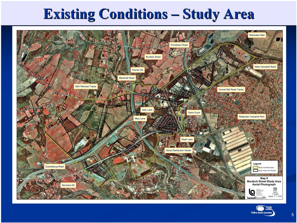
8 Existing Conditions Study Area 6

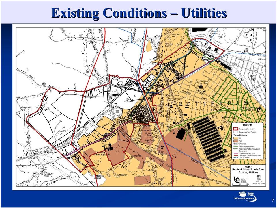
9 Existing Conditions Utilities 7
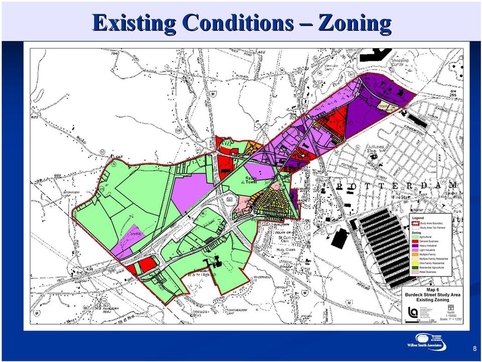
10 Existing Conditions Zoning 8
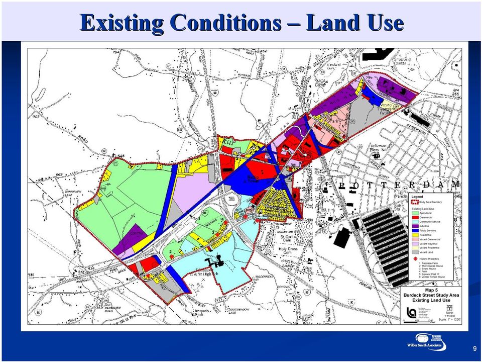
11 Existing Conditions Land Use 9
12 Existing Land Use Districts R-1 1 Retail Business = General Suburban Business & Retail R-2 2 General Business = Highway Business & Retail Light Industrial = Light Industrial, Labs, Retail Business, Offices & More Agriculture = Agricultural & I Acre Density Residential 10

13 New Land Use Districts Regional Retail = Large Scale Retail Mixed Use = Retail, Office, & Residential Modified Light Industrial = Limited Clean Light Industrial, Labs, Technology Office = Professional & Medical Offices, Hotels Rural = Agricultural & Very Low Density Residential 11

14 Alternative Land Use Scenario No Action NO ACTION ALTERNATIVE - EXISTING ZONING Keeping the zoning in its current designations will promote the continuation of the current development trends. Because the Town will not have updated the zoning, it will be more open to successful requests from individual landowners to modify their zoning to either existing industrial or existing commercial districts. These current districts are less restrictive on the types of allowed uses than most of the proposed districts for the area. 12

15 Alternative Land Use Scenario A ALTERNATIVE A The focus of Alternative A is to codify the basic recommendations of the Town Plan of Development. It replaces much of the current zoning with the modified industrial district in the northern portions of the Study Area or the regional commercial district near the Interstate Exit onto NY Route 7. There are minor changes, such as the modification of the wetland mitigation parcel to the Agricultural Distinct, and the modification of other districts to match parcel boundaries. Alternative A leaves the area northwest of I-88 primarily in the Agricultural District. 13

16 Alternative Land Use Scenario B ALTERNATIVE B Alternative B is meant to also fulfill the recommendations of the Town Plan, but with slightly more discretion as to how the industrial/commercial designation is interpreted. It places more of the regional retail District in the northern portions of the Study Area, to compliment the nearby existing regional retail development. The central portion of the Study Area keeps much of the light industrial focus, but uses the Modified Light Industrial District. The central portion along Mariaville Road is also placed into the Regional Retail District. The majority of the southern portion of the Study Area near the Interstate Exit on NY Route 7 is placed in the Office District. Alternative B recommends putting al of the area northwest of I-88 in the Agricultural District. 14

17 Alternative Land Use Scenario C ALTERNATIVE C Alternative C focuses on increasing the amount of office space in the Town. While it leaves much of the existing light industrial development in the Modified Light Industrial District, it places much of the other areas in the new Office District. Alternative C leaves almost the entire area northwest of I-88 in the Agricultural District. 15

18 Alternative Land Use Scenario D ALTERNATIVE D Promoting a significant amount of mixed use development is the focus of Alternative D. It places much of the Study Area in the Mixed Use District, which will encourage a more village like type of development that promotes residential, commercial, office and retail uses in close proximity to each other. This alternative includes more acreage in multi- and singlefamily development. This alternative also recommends creating a new Rural District that encourages the preservation of the Town s remaining agricultural areas by minimizing the development potential. 16

19 Bicycle System 17
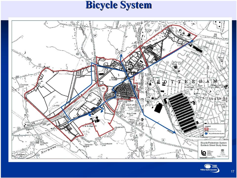
20 Alternative Land Use Scenarios BURDECK STREET/EXIT 25A STUDY Alternative Analysis Scenario No Action - Existing Zoning A B C D Land Use Compatible Potential Residential/Industrial conflicts Potential Residential/Industrial conflicts Possible Residential/Office conflicts Minimal conflicts Vehicular Signficantly worse congestion Minimal Increases in congestion Some increase in congestion Increased peak hour congestion Some increased congestion Circulation Bicycle Difficult Difficult Acceptable Good Good Circulation Pedestrian Difficult Difficult Acceptable Good Excellent Circulation Environmental Variable Variable Variable Variable Variable Impacts Economics Variable Some improvement assuming market exists Improved assuming market exists Improved assuming market exists Improved assuming market exists July 27,

21 Comments Discussion 19
22 Schedule May 3, First Public Work Session Mid May Steering Committee Work Session May Second Public Work Session Late June Steering Committee Work Session Early July 2004 Final Public Work Session 20
23 Burdeck Street/Exit 25A Study 21
24 Burdeck Street/Exit 25A Study Thank You! 22
25 23
INTRODUCTION TO ZONING DISTRICT REGULATIONS
 INTRODUCTION TO ZONING DISTRICT REGULATIONS Classification of Zoning Districts Zoning districts in Dorchester County are categorized as Suburban Urban, Suburban Transition, or Rural. These districts are
Corridor Goals and Objectives
 Corridor Goals and Objectives This chapter presents the goals and objectives, developed by the Corridor Study Committee, that serve as the purpose and intent of the Corridor Plan. This plan covers a twenty
Rezoning case no. RZ15-08: Adam Development Properties, LP
 PLANNING AND ZONING COMMISSION STAFF REPORT June 4, 2015 Rezoning case no. RZ15-08: Adam Development Properties, LP CASE DESCRIPTION: LOCATION: a request to amend the development plan of a previously-approved
Presentation to Knox County Commission Monday, February 23, 2015
 The Northwest County Sector Plan Update Presentation to Knox County Commission Monday, February 23, 2015 COMMUNITIES OF THE NORTHWEST COUNTY SECTOR Ball Camp Cedar Bluff Last NW Sector Update: 2003 Land
The Metropolitan Planning Commission. DATE: May 19, 2015
 TO: FROM: The Metropolitan Planning Commission MPC Staff DATE: May 19, 2015 SUBJECT: Petition of LLC, Owner Harold Yellin, Agent PIN: 2-0015-01-002 & 003 Lot Size:.85 Acres (approximately) Aldermanic District:
Application No.: 14.074 Steve Rush, representing Rocky Mountain Power Rocky Mountain Power Project Location: approximately 1600 N. 6800 E.
 Planning Commission Staff Report Planning and Development Services Croydon Substation Conditional Use Permit Public Meeting August 28, 2014 Application No.: 14.074 Applicant: Steve Rush, representing Rocky
Goals & Objectives. Chapter 9. Transportation
 Goals & Objectives Chapter 9 Transportation Transportation MISSION STATEMENT: TO PROVIDE A TRANSPORTATION NETWORK CAPABLE OF MOVING PEOPLE AND GOODS EFFICIENTLY AND SAFELY. T he transportation system
How To Improve Service In Arundel
 Draft of Economic Development Strategy - Town of Arundel Chapter 3.3 - Infrastructure, Transportation and Zoning 1. Infrastructure The lack of infrastructure in Arundel could present significant problems
KEYPORT COMMUNITY PLAN
 PLANNING COMMISSION TASKS Collect Public Comments on Draft Plan. Provide Clear Direction for: Preferred LAMIRD Boundary Lot Clustering Provision View Protection Recommendation to Board of County Commissioners.
Draft Goals and Objectives Wadena Comprehensive Plan City of Wadena, Minnesota. Land Use Goals:
 Draft Goals and Objectives Wadena Comprehensive Plan City of Wadena, Minnesota Land Use Goals: 1. Growth in Wadena will be undertaken in such a manner as to create a full range of living, working, shopping,
SAN DIEGO CREEK NORTH. Prepared for: City ofnewport Beach 3300 Newport Blvd. Newport Beach, CA 92663
 SAN DIEGO CREEK NORTH ANDJAMBOREE~ACARTHUR PLANNED COMMUNITY DISTRICT REGULATIONS Prepared for: City ofnewport Beach 3300 Newport Blvd. Newport Beach, CA 92663 Prepared by: The Irvine Company 550 Newport
Transportation Policy and Design Strategies. Freight Intensive. Level of Freight Presence
 Appendix G Transportation Policy and Design Strategies CONTEXT SENSITIVE SOLUTIONS To address the need to describe freight systems which account for the population distress which may result, an analysis
12 February 8, 2012 Public Hearing APPLICANT:
 12 February 8, 2012 Public Hearing APPLICANT: PROPERTY OWNER: VIRGINIA BEACH ASSOCIATES, LC REQUEST: Conditional Change of Zoning (I-1 to Conditional A-36) STAFF PLANNER: Faith Christie ADDRESS / DESCRIPTION:
Restoration. a brief look at
 Copyright 2009 Canin Associates, Inc. All rights reserved. No part of this publication may be reproduced or transmitted by any means without written permission from Canin Associates, Inc. a brief look
FILE NO.: Z-8403. LOCATION: Located on the Northeast and Southeast corners of West 12 th Street and Dennison Street
 FILE NO.: Z-8403 NAME: Glason Short-form POD LOCATION: Located on the Northeast and Southeast corners of West 12 th Street and Dennison Street DEVELOPER: Dennis Glason c/o the Law Office of Simmons S.
COUNTY OF ALBEMARLE PLANNING STAFF REPORT SUMMARY. Staff: Claudette Grant
 COUNTY OF ALBEMARLE PLANNING STAFF REPORT SUMMARY Project Name: ZMA 2013-00004 Hollymead Town Center Block VI Planning Commission Public Hearing: July 29, 2014 Staff: Claudette Grant Board of Supervisors
Iowa Smart Planning. Legislative Guide March 2011
 Iowa Smart Planning Legislative Guide March 2011 Rebuild Iowa Office Wallace State Office Building 529 East 9 th St Des Moines, IA 50319 515-242-5004 www.rio.iowa.gov Iowa Smart Planning Legislation The
SECTION ONE CHAPTER 2: A LAND USE PROFILE OF MANCHESTER
 SECTION ONE CHAPTER 2: A LAND USE PROFILE OF MANCHESTER Land use is the central element of a comprehensive plan because it establishes the overall physical configuration of the city, including the mix
Village of Spring Valley Comprehensive Plan 2009-2029
 Chapter 8: Intergovernmental Cooperation Introduction Intergovernmental communication, coordination, and cooperation can make a significant difference in the implementation and administration of a comprehensive
Market Analysis for Padre Boulevard Initiative in the Town of South Padre Island, TX
 Market Analysis for Padre Boulevard Initiative in the Town of South Padre Island, TX Prepared for Gateway Planning Group Spring 2010 TXP, Inc. 1310 South 1st Street; Suite 105 Austin, Texas 78704 (512)
Attachment B Policy Audit Template
 Attachment B Policy Audit Template 5 6 7 8 9 0 Provide A Variety of Transportation Choices Provide A Variety of Transportation Choices Provide A Variety of Transportation Choices Encourage transit-oriented
Appendix J Santa Monica Travel Demand Forecasting Model Trip Generation Rates
 Appendix J Santa Monica Travel Demand Forecasting Model Trip Generation Rates SANTA MONICA TRAVEL DEMAND FORECASTING MODEL TRIP GENERATION RATES SUBMITTED BY: 201 Santa Monica Blvd., Suite 500 Santa Monica,
Land Use and Zoning. Land Use Within the Port Madison Indian Reservation
 Land Use and Zoning Land Use Within the Port Madison Indian Reservation A portion of the Suquamish Rural Village is Trust land, owned either by the Tribe or individual tribal members. The following list
2010 Salida Community Priorities Survey Summary Results
 SURVEY BACKGROUND The 2010 Salida Community Priorities Survey was distributed in September in an effort to obtain feedback about the level of support for various priorities identified in the draft Comprehensive
# U N I V E R S I T Y A V E N U E S P E C I F I C P L A N Page 1-1 # 1.0 INTRODUCTION. 1.1 University Avenue, Historical Context
 1.0 INTRODUCTION 1.1 University Avenue, Historical Context By the late 1880s, the role of University Avenue, then known as Eighth Street, was already well established as a link between the original Riverside
COUNTY OF EL DORADO DEVELOPMENT SERVICES ZONING ADMINISTRATOR STAFF REPORT SPECIAL USE PERMIT
 COUNTY OF EL DORADO DEVELOPMENT SERVICES ZONING ADMINISTRATOR STAFF REPORT Agenda of: January 20, 2010 Item No.: Staff: 4.a. Aaron Mount SPECIAL USE PERMIT FILE NUMBER: APPLICANTS: REQUEST: LOCATION: S08-0030/Birt
AGENDA LARIMER COUNTY PLANNING COMMISSION Wednesday, April 20, 2016/6:30 P.M./Commissioners' Hearing Room
 AGENDA LARIMER COUNTY PLANNING COMMISSION Wednesday, April 20, 2016/6:30 P.M./Commissioners' Hearing Room A. CALL TO ORDER B. PLEDGE OF ALLEGIANCE C. PUBLIC COMMENT ON THE COUNTY LAND USE CODE D. PUBLIC
Texas Motor Speedway Area Master Plan January 2009 WATER INFRASTRUCTURE
 WATER AND SEWER INFRASTRUCTURE Water and Sewer Infrastructure in the TMS Study Area Streets and other transportation infrastructure are addressed in Chapter 6 of this plan. Non-transportation infrastructure
FINAL DRAFT FINAL DRAFT
 MovingDutchess2 Figure3 1.DutchessCounty withintheregion Chapter3 RegionalPerspective DutchessCountyislocatedatthecenteroftheHudsonValley, halfwaybetweennewyorkcityandalbany.itisatthe northernreachesofnewyorkcitycommutingdistance,yet
Citizen Advisory Group Meeting #1 December 8, 2011 6:00 p.m.
 Citizen Advisory Group Meeting #1 December 8, 2011 6:00 p.m. Meeting Agenda 1. Background Information 2. Policy Framework 3. Plan Development Process 4. Public Input Results 5. Vision Statement 6. Group
REZONING 16-000009 & PRELIMINARY PLAT 16-000005
 REZONING 16-000009 & PRELIMINARY PLAT 16-000005 REZONING REQUEST AND REVISED PRELIMINARY PLAT FOR THE BLUFFS AT WINDCASTLE - 4165 FAREDALE LANE Application: Engineer: Developer: Property Owner: Current
STAFF REPORT. December 20, 2004. North District Community Council. Director of Community Planning - North
 STAFF REPORT December 20, 2004 To: From: Subject: North District Community Council Director of Community Planning - North Preliminary Report Respecting Revised Application OPA & Rezoning Application 01
Opal Service District Plan
 8 The Opal Service District includes a variety of planned land uses including commercial, mixed-use, flex office, industrial, and hospitality. This Plan seeks to simplify the land use categories to allow
TABLE OF CONTENTS. INTRODUCTION...1 Purpose of a Comprehensive Plan...1 McKenzie County Comprehensive Plan...1 Definitions...2 Goal...2 Vision...
 MCKENZIE COUNTY COMPREHENSIVE PLAN TABLE OF CONTENTS INTRODUCTION...1 Purpose of a Comprehensive Plan...1 McKenzie County Comprehensive Plan...1 Definitions...2 Goal....2 Vision...3 ECONOMIC DEVELOPMENT...4
WESTFIELD-WASHINGTON ADVISORY PLAN COMMISSION December 7, 2015 1512-SPP-24 & 1512-ODP-24
 Petition Number: Subject Site Address: Petitioner: Request: East side of Oak Road, north of 151 st Street Langston Development Co. Primary Plat and Overall Development Plan amendment review for Mapleridge
CITY COUNCIL / PLANNING COMMISSION JOINT STUDY SESSION AGENDA REPORT
 CITY COUNCIL / PLANNING COMMISSION JOINT STUDY SESSION AGENDA REPORT MEETING DATE: SEPTEMBER 8, 2015 ITEM NUMBER: 1 SUBJECT: PROPOSED GENERAL PLAN LAND USE ALTERNATIVE FOR THE YEAR 2015-2025 GENERAL PLAN
K A N S A S DEPARTMENT OF HEALTH AND ENVIRONMENT PERMIT APPLICATION FOR A RECLAMATION FACILITY. 1. Applicant's Name
 K A N S A S DEPARTMENT OF HEALTH AND ENVIRONMENT PERMIT APPLICATION FOR A RECLAMATION FACILITY 1. Applicant's Name Address (Street or Rural Route) (City & State) (Zip) Person to contact Title Phone Fax
Chapter 13: Implementation Plan
 Chapter 13: 13.1. INTRODUCTION The purpose of the implementation chapter of the Comprehensive Plan is to set forth the actions that the City will take to ensure that the plans, programs and policies set
SPECIAL USE PERMIT 22-01. JCSA Groundwater Treatment Facility Staff Report for the November 5, 2001, Planning Commission Public Hearing
 SPECIAL USE PERMIT 22-01. JCSA Groundwater Treatment Facility Staff Report for the November 5, 2001, Planning Commission Public Hearing This report is prepared by the James City County Planning Division
Major General Plan Amendment. Project Narrative
 Major General Plan Amendment BARNEY FARMS Project Narrative NEC of Signal Butte and Queen Creek Roads Prepared: Submitted to: TOWN OF QUEEN CREEK PLANNING DEPARTMENT 22350 South Ellsworth Road Queen Creek,
NYCIDA PROJECT COST/BENEFIT ANALYSIS June 5, 2014
 NYCIDA PROJECT COST/BENEFIT ANALYSIS June 5, 2014 APPLICANT Skyline Restoration Inc. CGI Northeast, Inc. Spring Scaffolding LLC Metropolitan Northeast LLC 11-20 37 th Avenue Long Island City, NY 11101
CONCEPT PLAN APPLICATION
 TOWN OF CHAPEL HILL CONCEPT PLAN APPLICATION Applicant Information Name: Jack L. Smyre, The Design Response, Inc. Address: 1014 High House Road, Suite 100 City: Cary State: North Carolina Zip: 27513 Phone
Town of Montezuma, New York Community Survey 2015
 Town of Montezuma, New York Community Survey 2015 The Montezuma Comprehensive Planning Committee and the Central New York Regional Planning & Development Board MONTEZUMA, NEW YORK COMMUNITY SURVEY PLEASE
A PPENDICES C OLLIERVILLE 2040 LAND USE PLAN UPDATE
 A PPENDICES C OLLIERVILLE 2040 LAND USE PLAN UPDATE Traditional Neighborhood Character Study with a Neighborhood Center Commercial Node Aldi s is appropriate in a Neighborhood Center School Greenbelt Trail
Frederick. Frederick. Maryland. Smart Growth Successes. Frederick. Maryland Department of Planning
 Frederick Frederick Maryland Smart Growth Successes Frederick Maryland Department of Planning Smart, Green & Growing Martin O Malley Governor Anthony G. Brown Lt. Governor Maryland Department of Planning
Town of Beaufort, NC US Highway 70 Commercial Project
 Town of Beaufort, NC US Highway 70 Commercial Project Context The North Carolina Department of Transportation is proposing a new bridge and highway alignment that will relocate U.S. Highway 70 from its
Chapter 7 ZONING PLAN
 Chapter 7 ZONING PLAN Introduction This Chapter opens with a general description of a zoning plan. It is followed by a brief explanation of the relationship between this Growth Management Plan and the
ASPEN HILL Minor Master Plan Amendment
 ASPEN HILL Minor Master Plan Amendment Agenda Welcome and Introductions (6:30 PM) Staff Presentation (6:40-7:30 PM) Q&A (7:30-8:00 PM) Community Meeting #2 April 1, 2014 Aspen Hill Library Planning Process
Downtown Tampa Transportation Vision
 Downtown Tampa Transportation Vision Executive Summary August 1, 2006 Hillsborough County Metropolitan Planning Organization County Center, 18 th Floor Tampa, Florida 33602 813-272-5940 www.hillsboroughmpo.org
Motorcycle & Pedestrian Master Plans in Indianapolis, Indiana
 PROJECT PURPOSE The Warsaw + Winona Lake Bicycle and Pedestrian Master Plan establishes a comprehensive framework for a connected bicycle and pedestrian system that will be used for both recreation and
APPENDIX F RIGHTS-OF-WAY PRESERVATION GUIDELINES
 Los Angeles County Metropolitan Transportation Authority (Metro) 2009 Transportation Improvement Program Call for Projects APPENDIX F RIGHTS-OF-WAY PRESERVATION GUIDELINES Los Angeles County Metropolitan
City of North Liberty, Iowa Comprehensive Plan
 City of North Liberty, Iowa Approved November 2013 2013 North Liberty Acknowledgments Table of Contents Page Introduction 2 Where We re at Today ning 3 Current Land Use 3 Population Estimates 4 Significant
01/31/13 ACHIEVING THE VISION FOR RESTON. Reston Master Plan Special Study Task Force
 ACHIEVING THE VISION FOR RESTON Reston Master Plan Special Study Task Force The Reston Master Plan Special Study Task Force was appointed by Hunter Mill District Supervisor Catherine Hudgins to review
PLANNING COMMISSION REPORT Regular Agenda - Public Hearing Item
 Z-15-00063 Item No. 1-1 PLANNING COMMISSION REPORT Regular Agenda - Public Hearing Item PC Staff Report 04/20/2015 ITEM NO. 1 Z-15-00063 CS TO RS5; 832 Ohio Street (BJP) Z-15-00063: Consider a request
7.0 INTRODUCTION 7.1 BACKGROUND
 Section 7: Economic Development 7.0 INTRODUCTION A community s character is a function of its residential neighborhoods, its open spaces, and its commercial districts. Commercial uses also play another
COUNTY OF ALBEMARLE PLANNING STAFF REPORT SUMMARY
 COUNTY OF ALBEMARLE PLANNING STAFF REPORT SUMMARY Project Name: ZMA 2010-00001 Pantops Ridge Planning Commission Public Hearing: January 11, 2011 Owners: Richard T. Spurzem Acreage: 37.5 acres TMP: TMP
Brookdale Site. CB6 Update April 1, 2015
 Brookdale Site CB6 Update April 1, 2015 Summary Timeline / Process How does DSNY operate now? Garage project and frequently asked questions Project facts Impact to emergency vehicle access Traffic congestion
APPENDIX B. Farmville Airport Access and Land Use Study. Individual Land Use Policy Reviews August 2008
 Introduction APPENDIX B Individual Land Use Policy Reviews August 2008 A land use policy review was undertaken to understand the land use and other inter-related policy issues that may influence the Farmville
FILE NO.: Z-6915-C. Gamble Road Short-form PCD and Land Alteration Variance Request
 FILE NO.: Z-6915-C NAME: Gamble Road Short-form PCD and Land Alteration Variance Request LOCATION: Located on the Northwest corner of Chenal Parkway and Gamble Road DEVELOPER: Davis Properties P.O. Box
AREA: 2.37 acres NUMBER OF LOTS: 1 FT. NEW STREET: 0 LF. Single-family, Non-conforming machine shop
 FILE NO.: Z-8958 NAME: Rock Structure Repair Short-form PID LOCATION: Located at 8024 Stanton Road DEVELOPER: Rock Structure Repair Attn. Rudy Gutierrez 3 Kipling Court Little Rock, AR 72209 ENGINEER:
EXHIBIT A LOCATION MAP AND LAND USE INFORMATION
 EXHIBIT A LOCATION MAP AND LAND USE INFORMATION In accordance with Arizona Corporation Commission Rules of Practice and Procedure R14-3-219, Applicant provides the following location maps and land use
DEPARTMENT OF TRANSPORT CYCLING STRATEGY 29 February 2008
 DEPARTMENT OF TRANSPORT CYCLING STRATEGY 29 February 2008 INTRODUCTION The Department of Transport s Business Plan for the 2007/08 financial year stated the following: Government Aim: Quality Environment
2015 -- H 6042 S T A T E O F R H O D E I S L A N D
 LC00 01 -- H 0 S T A T E O F R H O D E I S L A N D IN GENERAL ASSEMBLY JANUARY SESSION, A.D. 01 A N A C T RELATING TO TOWNS AND CITIES -- RHODE ISLAND COMPREHENSIVE PLANNING AND LAND USE ACT Introduced
A REQUEST FOR A CONDITIONAL USE PERMIT BY:
 A REQUEST FOR A CONDITIONAL USE PERMIT BY: National Outdoor Leadership School (NOLS), FOR: The expansion of their existing education facility, WHERE: Darby Townsite (1830 S 1750 E) Prepared for the Public
Conducting a Land Use Inventory
 Chapter 3 Conducting a Land Use Inventory Included in this chapter: Determining Current Land Use Conditions Preparing a Base Map Deciding on Land Use Categories Collecting Current Land Use Data Preparing
 Snohomish County Department Of Public Works (DPW) Rules Adopted Pursuant to the Rulemaking Requirements of Chapter 30.82 SCC Providing Detail and Specificity for the Traffic Mitigation and Concurrency
Case 1775. Request: Rezone from (A) Agricultural District and (RA) Single Family Residential District to (RB) Two Unit Residential District
 Agricultural District and (RA) Single Family Residential District to (RB) Two Unit Residential District") Case 1775 Applicant: York Breckenridge GP, LLC 1301 South Capital of Texas Highway Suite B-201 Austin Texas.778746 512-369-3030 Request: Rezone from (A) Agricultural District and (RA) Single Family Residential
Case 1775 Applicant: York Breckenridge GP, LLC 1301 South Capital of Texas Highway Suite B-201 Austin Texas.778746 512-369-3030 Request: Rezone from (A) Agricultural District and (RA) Single Family Residential
LAND USE ELEMENT APPENDIX
 II LAND USE ELEMENT APPENDIX Arnold Community Plan CHART C CONSISTENT ZONES, POPULATION DENSITY, BUILDING INTENSITY Land use designation Consistent Dwellings Persons Zone per acre per acre Single family
Planning Commission Staff Report
 10 Planning Commission Staff Report TO: FROM: THROUGH: PLANNING COMMISSION AMY TEMES, SENIOR PLANNER (480) 503-6729, AMY.TEMES@GILBERTAZ.GOV CATHERINE LORBEER, AICP, PRINCIPAL PLANNER (480) 503-6016 CATHERINE.LORBEER@GILBERTAZ.GOV
CITY OF NORMANDY PARK MANHATTAN VILLAGE REDEVELOPMENT AREA STRATEGY AND CONCEPTUAL MASTER PLAN
 CITY OF NORMANDY PARK MANHATTAN VILLAGE REDEVELOPMENT AREA STRATEGY AND CONCEPTUAL MASTER PLAN Project Purpose The City of Normandy Park is studying ways to help property owners in the Manhattan Village
ALACHUA COUNTY COMPREHENSIVE PLAN 2011-2030
 ALACHUA COUNTY COMPREHENSIVE PLAN 2011-2030 Adopted April 5, 2011 (Ordinance 11-01, Effective July 22, 2011; Housing Element effective August 23, 2011) Updated through January 21, 2016 Alachua County Growth
STAFF REPORT AND RECOMMENDATIONS PLANNING & DEVELOPMENT SERVICES DIVISION COMMUNITY DEVELOPMENT DEPARTMENT
 MEMO DATE: April 24, 2015 AGENDA DATE: May 7, 2015 STAFF REPORT AND RECOMMENDATIONS PLANNING & DEVELOPMENT SERVICES DIVISION COMMUNITY DEVELOPMENT DEPARTMENT TO: FROM: SUBJECT/CASE: City of Largo Planning
HRTPO PROJECT PRIORITIZATION AND SELECTION PROCESS PROJECT CATEGORIES AND EVALUATION CRITERIA
 HRTPO PROJECT PRIORITIZATION AND SELECTION PROCESS PROJECT CATEGORIES AND EVALUATION CRITERIA September 24, 2009 Intermodal Projects Better Accommodates Intermodal Movements Improves Rail or Vehicular
Fiscal impact analysis of three development scenarios in Nashville-Davidson County, TN
 Fiscal impact analysis of three development scenarios in Nashville-Davidson County, TN April 2013 Prepared by 1 SUMMARY BY SMART GROWTH AMERICA Summary This study examines the relative fiscal costs and
Village of Royal Palm Beach
 Village of Royal Palm Beach Comprehensive Plan Comprehensive Plan Adopted 2009 Village of Royal Palm Beach Page 1 Table of Contents Introduction Page 3 Future Land Use Element Page 4 19 Future Land Use
EAST BETHEL PLANNING COMMISSION MEETING June 24, 2014
 EAST BETHEL PLANNING COMMISSION MEETING June 24, 2014 The East Bethel Planning Commission met for a Regular Planning Commission Meeting on June 24, 2014 at 7:00 P.M for their regular meeting at City Hall.
REPORT OF THE PLANNING AND DEVELOPMENT DEPARTMENT FOR APPLICATION FOR REZONING ORDINANCE 2015-0183 TO PLANNED UNIT DEVELOPMENT APRIL 9, 2015
 AWH REPORT OF THE PLANNING AND DEVELOPMENT DEPARTMENT FOR APPLICATION FOR REZONING ORDINANCE 2015-0183 TO PLANNED UNIT DEVELOPMENT APRIL 9, 2015 The Planning and Development Department hereby forwards
PLANNED UNIT DEVELOPMENT & SIDEWALK WAIVER REQUEST STAFF REPORT Date: November 7, 2013
 PLANNED UNIT DEVELOPMENT & SIDEWALK WAIVER REQUEST STAFF REPORT Date: November 7, 2013 NAME LOCATION Audubon Properties, LLC. 4700 & 4960 Dauphin Island Parkway West side of Dauphin Island Parkway, 580
Downtown South Salt Lake Redevelopment City of South Salt Lake
 Project Information LOCAL PLANNING RESOURCE PROGRAM 2015 Downtown South Salt Lake Redevelopment City of South Salt Lake Overview of Objectives: Building a downtown city center could be the most significant
CITY OF GREEN COVE SPRINGS COMPREHENSIVE PLAN 2025
 CITY OF GREEN COVE SPRINGS COMPREHENSIVE PLAN 2025 Adopted August 2, 2011 CITY OF GREEN COVE SPRINGS COMPREHENSIVE PLAN 2025 ADOPTED 8/2/2011 TABLE OF CONTENTS Future Land Use Element... 1 Transportation
AREA: 0.16 acres NUMBER OF LOTS: 1 FT. NEW STREET: 0 LF
 FILE NO.: Z-9020 NAME: Hometown Tax Service Short-form PD-O LOCATION: Located at 3008 West 12 th Street DEVELOPER: Mark Green 65 Westfield Loop Little Rock, AR 72210 SURVEYOR: Kittler-Roberts Group, LLP
NOTICE OF PREPARATION
 PLANNING DIVISION CITY OF SUNNYVALE P.O. BOX 3707 SUNNYVALE, CA 94088-3707 NOTICE OF PREPARATION TO: Responsible, Trustee, and Other Interested Public Agencies FROM: Sunnyvale Community Development 456
INSTITUTIONAL MASTER PLAN NOTIFICATION FORM / PROJECT NOTIFICATION FORM BOSTON UNIVERSITY MEDICAL CENTER
 INSTITUTIONAL MASTER PLAN NOTIFICATION FORM / PROJECT NOTIFICATION FORM BOSTON UNIVERSITY MEDICAL CENTER JUNE 7, 2013 SUBMITTED TO: BOSTON REDEVELOPMENT AUTHORITY ONE CITY HALL SQUARE BOSTON, MA 02201
APPENDIX F ACCESS MANAGEMENT PLAN STATEMENT OF WORK
 APPENDIX F ACCESS MANAGEMENT PLAN STATEMENT OF WORK I. INTRODUCTION The Oregon Department of Transportation (ODOT) will work with the (City or County) to develop an Access Management Plan (AMP) in compliance
VANDERBILT COMPARISON
 Village of Vanderbilt Comparison One County, One Vision Master Plan (2000) 1 15 Improve recreation in Otsego County by assessing the availability and need to improve bike paths, county recreation facilities,
Appendix C Related Studies
 Appendix C Related Studies Intermodal Transit Village Concept Plan Appendix C Related Studies This appendix summarizes studies that are current at the time of this Plan. Intermodal Transit Village Concept
COMMUNITY WORKSHOP #2
 COMMUNITY WORKSHOP #2 General Plan Elements Update April 28, 2015 Today s Agenda I. Project Purpose What Are We Doing and Why! II. What is a General Plan? III. Project Overview/Timeline IV. Community Input
City of Tampa Zoning Districts
 City of Tampa Zoning Districts The city is divided by chapter 2 into zoning districts, the boundaries and designations of which are shown in a series of maps, covering in combination the entire land and
PLANNING APPLICATION: 12/00056/APP
 PLANNING APPLICATION: 12/00056/APP In the event that a recommendation on this planning application is overturned the Committee is reminded of the advice contained on the front page of the agenda for Reports
Michigan State University Ingham County Health Department Tri- County Regional Planning Commission Land Use and Health Resource Team
 HEALTH IMPACT ASSESSMENT OF THE URBAN AND RURAL SERVICES MANAGEMENT POLICY Mid- Michigan Region Health In All Project Michigan State University Ingham County Health Department Tri- County Regional Planning
DRAFT Policy to Guide Discretion on Proposed Relaxations to Minimum Parking Requirements in Commercial Districts City-Wide 2014 June 05
 PARKING INITIATIVES Attachment I Corridor Program Descriptions Corridor Program Pilot Though the Corridor Program will officially launch in the fall, this summer, The City will pilot the first phase of
STAFF REPORT PLANNING COMMISSION REGULAR MEETING OF OCTOBER 20, 2015. Debbie Hill, Associate Planner dhill@brentwoodca.gov 9386-A1
 STAFF REPORT PLANNING COMMISSION REGULAR MEETING OF OCTOBER 20, 2015 PREPARED BY: AGENDA ITEM & FILE NUMBER: PROJECT DESCRIPTION: PROJECT SIZE & LOCATION: GENERAL PLAN: ZONING: OWNER/APPLICANT: Debbie
5 March 12, 2014 Public Hearing
 5 March 12, 2014 Public Hearing APPLICANT: MOORE FARM, L.L.L.P. PROPERTY OWNER: MOORE FARM L.L.L.P. STAFF PLANNER: Kevin Kemp REQUEST: Change of Zoning (B-1A Limited Community Business to Conditional B-2
Short-term. Action items that fall into this category need to take place over the next one to two years.
 Implementation Plan Building Momentum Through Incrementalism Queensbury s vision for its future, which emerged from public discussion over the past year, is as a vibrant regional center for living, working,
Significant investment and improvement of infrastructure and transport networks, delivered at no cost and no risk
 December 2014 FACT SHEET: TRANSPORT AND INFRASTRUCTURE Significant investment and improvement of infrastructure and transport networks, delivered at no cost and no risk The Gold Coast Integrated Resort
GRO MUNIC. City of Gaithersburg. A Master Plan Element X-7067-2015 22-J X-7089-2015. Adopted April 6, 2009. Published April 14, 2009
 City of Gaithersburg MUNIC GRO A Master Plan Element Adopted April 6, 2009 Published April 14, 2009 Mayor and City Council X-7089-2015 X-7067-2015 22-J City of Gaithcrsburg 2003 Master Plan: Municipal
Los Angeles Union Station, CA Sustainable Neighborhood Assessment. April 22-23, 2014
 Los Angeles Union Station, CA Sustainable Neighborhood Assessment April 22-23, 2014 Sustainable Neighborhood Assessment Through the Sustainable Neighborhood Assessment Tool developed by Global future development
21.03 SETTLEMENT AND HOUSING
 21.03 SETTLEMENT AND HOUSING 09/10/2014 C187Prop osed C189 21.03-1 Housing 09/10/2014 C187 This clause provides local content to support Clause 11 (Settlement) and 15 (Built Environment and Heritage) and
PLANNING FOR NEW DEVELOPMENT AT THE COTTONWOOD MALL SITE
 APPENDIX F PLANNING FOR NEW DEVELOPMENT AT THE COTTONWOOD MALL SITE Table of Contents The Setting Background Planning Objectives Neighborhood Protection The Concept Plan Exhibits Cottonwood Mall Site 1
MARION COUNTY FLORIDA COMMISSIONERS COUNTY ADMINISTRATOR PLANNING DEPARTMENT
 MARION COUNTY FLORIDA COMMISSIONERS Charlie Stone, Chairman Jim Payton, Vice Chairman Andy Kesselring Stan McClain Barbara Fitos COUNTY ADMINISTRATOR Patrick Howard PLANNING DEPARTMENT Dwight Ganoe, Director