THE ENVIRONMENT OF SOUTH FLORIDA, A SUMMARY REPORT
|
|
|
- Melanie Reynolds
- 8 years ago
- Views:
Transcription
1 THE ENVIRONMENT OF SOUTH FLORIDA, A SUMMARY REPORT GEOLOGICAL SURVEY PROFESSIONAL PAPER 1011 U.S. DEPARTMENT OF THE INTERIOR Resource and Land Investigations (RALI) Program

2 THE ENVIRONMENT OF SOUTH FLORIDA, A SUMMARY REPORT By B. F. McPherson, C. Y. Hendrix, Howard Klein, and H. M. Tyus GEOLOGICAL SURVEY PROFESSIONAL PAPER 1011 A description of the south Florida ecosystem and changes resulting from man's activities UNITED STATES GOVERNMENT PRINTING OFFICE : 1976

3 Foreword The South Florida Environmental Study indicates a growing awareness of the necessity for man to understand the relationship between his own actions and the response of the natural environment to them. Studies of this kind provide a means for man, if he so chooses, to select activities which should be undertaken to enhance the human condition and yet avoid the disastrous ecological consequences that sometime result from actions taken without understanding the natural processes that may be affected. This study summarizes events that began in 1971 as the efforts of seven Federal agencies to deal with one particular problem - a controversial proposed jetport at the edge of Everglades National Park - and carries them to the point where Federal, State, regional, county, and local government bodies could begin to function innovatively as a working team. Progress to date has occurred in two stages: Phase one, the results of which are summarized in this report, was the Federal effort to develop the scientific information base needed by Federal, State, and local land-resource managers to make informed decisions affecting both the economy and environment of south Florida. Phase two, already well underway, is the cooperative attempt by all levels of government and their appropriate agencies to utilize the information developed during the phase one effort to make land and water-use decisions for south Florida that not only protect the region s outstanding natural resources but provide economic vitality as well. Such a working rapprochement between the economy and the environment demands wide citizen participation. Phase two is working to raise general understanding of the basic system of man and nature - the economy and the environment - and how it interacts. As a byproduct of this cooperative process, the general public is becoming involved to the point that it understands the factors that control its destinies. With this understanding comes the ability of citizens to express their desires to resource managers and elected officials. I believe that every additional measure of wisdom that accrues to the citizenry of this Nation enriches our decisionmaking process and contributes to the maintenance of our economy, our environment... our very way of life. ii

4 As a result of the phase one work, it is concluded that the following steps should be taken to protect the south Florida ecosystem from further damage and degradation: 1. Determine, through local and State governments, human population carrying capacity for the region and for the subunits of the region that is compatible with the goal of no further environmental degradation and with resources and energy constraints; 2. Adopt, through local and State governments, a land-use plan based on this determination of carrying capacity; 3. Pass State and local legislation that supports the land-use plan and creates enforcement machinery for its implementation; and 4. Monitor the essential natural resource, economic, sociologic, and energy factors to ensure that the regional policy and land-use plan are being followed. Centralize, standardize, and publish this information on a regular basis. The problems that set this study in motion have not all been solved. Indeed, many of them have changed and some have totally disappeared. But a host of new ones have taken their places and wait now upon the wisdom we have so far gleaned. What has been created is a better grasp of the underlying causes for south Florida's environmental problems and some new ways of getting a handle on the slippery nature of change. The challenge that remains is to arrive at rational solutions and to implement them. This cannot be "done," in the sense of finishing. It will require a continuing dialogue and coordinated effort from all the parties that have been involved. What follows is a study of the components and processes that constitute the south Florida environmental system, a look at the resources of both man and nature and how they can be made to fit together to form alternative viable futures. It is intended to serve as a departure point for the on-going phase two study and for the State and county land-use plans yet to emerge. Thomas S. Kleppe Secretary of the Interior August 23, 1976 iii

5 Preface In 1968 the planned construction of an international jetport in the Big Cypress Swamp of south Florida by the Dade County Port Authority triggered a controversy and a series of events that involved private and public interest. Local conservation groups and concerned citizens questioned the potential effects of such a jetport and the attendant urban growth in the Big Cypress Swamp both on the nearby Everglades National Park and on the south Florida environment. The Federal Government initiated, through the U.S. Department of the Interior, a preliminary study to evaluate the environmental impact of the proposed jetport. That study (Leopold and others, 1969) indicated that the proposed jetport would adversely affect not only the ecosystem of Everglades National Park, but that of the remainder of south Florida as well. For that reason the Federal Government opposed the construction of the jetport at the proposed location. In the pact with Dade County and the State of Florida, the Federal Government agreed, however, to aid in the location and purchase of a new and acceptable site for the jetport. An obligation of the Federal Government under this pact was to implement an ecological study of south Florida. Five bureaus of the Department of the Interior - National Park Service, Geological Survey, Bureau of Sport Fisheries and Wildlife (now Fish and Wildlife Service), Bureau of Outdoor Recreation, and the Bureau of Indian Affairs - and two former Interior agencies - Federal Water Quality Administration (now Environmental Protection Agency) and Bureau of Commercial Fisheries (now National Marine Fisheries)- were asked to participate. These bureaus and agencies completed 51 separate reports (available through the US. Department of Commerce, National Technical Information Service). This summary report, which is an overview of the south Florida environment, is based on and covers the highlights of the 51 reports. The abstract of each is included in the References. The South Florida Environmental Study identified and described the natural ecosystems of south Florida as they functioned before man began to have major impacts on these systems. Where remnants of natural systems still function as before, they were measured and described. The study also encompassed the agricultural and urban developments of south Florida and their impacts on the ecosystems. Man is a natural component of the system and, like all living components, seeks to attain some degree of balance or equilibrium with the rest of the system. This report concludes phase one of the South Florida Environmental Study and fulfills in part the Department of the Interior's obligation to Dade County and the State of Florida to study and report upon the south Florida environment. A second phase of the South Florida Environmental Study, now nearing completion, began in 1974 with a joint agreement among the State of Florida, the US. Department of the Interior, and the University of Florida Center for Wetlands, designating specific products from three participating bodies. iv

6 The Center for Wetlands was to (1) prepare land use maps of the south Florida region as a whole and of three demonstration counties within the region - Lee, Collier, and Hendry - showing them in their primitive state, as they were in 1953, and as they had become by 1973; and (2) to produce models of the ecological systems defined and/or described in the phase one study. These models were to determine, to the extent possible, flows and storages of energy in the south Florida environment and in select instances to make predictions and recommendations for water, land, and energy use, and for a carrying capacity that could sustain a viable economy and environment in the region. The Florida Division of State Planning agreed to prepare and publish four reports - one for the south Florida region as a whole and one each for the three counties, Hendry, Lee, and Collier. The reports were to be written in laymen's language and contain the results of the Center for Wetlands modeling studies, together with copies of the regional maps. It was also agreed that the State would fund a full-time planner in each of the three demonstration counties, to work with the county planning departments on integrating the modeling study results and recommendations with the developing county land-use plans. The State effort was also to relate these activities to the Division of State Planning's legislated responsibilities under the Florida Environmental land and Water Management Act of The Department of the Interior, in addition to substantial funding of the phase two project, agreed to help provide the data base for the Center for Wetlands modeling and to arrange for its own agencies' review of the resulting products. It is Interior's responsibility under terms of the joint agreement to publish the technical report emanating from the Center for Wetlands modeling studies. That report will be published by the National Park Service. v

7 Contents Foreword Preface Synopsis History of the South Florida Environmental Study South Florida as a regional system of man and nature The early ecosystem The changing system - population growth and land-use changes Ecosystem models as an approach to resource management Ecosystems of south Florida Freshwater and terrestrial ecosystems Relations between systems Effects of man Canals and lakes Ponds and sloughs Sawgrass marsh Wet prairies Pine forests Cypress forests Mixed swamp forests Bay heads Hardwood hammocks Palmetto and dry prairies Coastal ecosystems Sandy beaches Mangroves and salt marshes Nutrient cycles in mangrove swamps Destruction of the mangrove shores Shallow estuaries and bays Bay-bottom communities Marine fisheries Florida reef tract Man-dominated ecosystems Agricultural systems Urban systems South Florida's hydrologic systems Importance of water to south Florida Aquifers Change in water balance in southeast Florida Hydrologic changes in southwest Florida Water-quantity problems in southwest Florida Water-resource limits in southeast Florida vi

8 South Florida's hydrologic systems - Continued Water quality The effects of water quality on man Water quality of the Big Cypress Swamp Water quality of Lake Okeechobee Water quality of the Everglades Water quality of the east coast urban and agricultural area Ground-water quality A final word References Appendices I.-An introduction to systems ecology and ecological modeling II.-Scientific names of plants and animals mentioned in the report ILLUSTRATIONS FIGURE 1. Map of south Florida showing features mentioned in the report 2. Federal and State administered lands in south Florida 3. Chronology of the South Florida Environmental Project 4. Flow of energy in the south Florida regional ecosystem 5. Map showing vegetation in south Florida as it existed before manmade alterations 6. Physiographic regions of south Florida 7. Generalized vegetative profile showing the relation of relative water depth to vegetative community 8. A sequence of vegetation change in south Florida 9. Generalized plant succession in south Florida 10. Shark River Slough 11. Water conservation areas 12. Everglades National Park 13. Big Cypress Swamp watershed 14. Western Flatlands and coast 15. Mangrove coastline of southwest Florida 16. Florida Bay and the Florida Keys 17. Florida reef tract 18. Lake Okeechobee and the adjoining agricultural area 19. Urbanized Atlantic Coastal Ridge 20. Generalized subsurface section showing aquifers of south Florida 21. Principal freshwater aquifers of south Florida 22. Dry-year outflows of freshwater in south Florida 23. Schematic diagram showing changes in the water balance in southeast Florida through Hydrograph of a well in the western Big Cypress Swamp, , compared to rainfall for the same period 25. Schematic diagram showing water balance in southeast Florida in Chloride concentration of water at two stations in Everglades National Park 27. Diagrammatic illustrations of energy flow vii

9 THE ENVIRONMENT 0F SOUTH FLORIDA, A SUMMARY REPORT By B. F. McPherson, 1 C. Y. Hendrix, 2 Howard Klein, 1 and H. M. Tyus 3 Synopsis After 1900 men came in increasing numbers to south Florida and began extensive modification of the vast wilderness of swamps, forests, marshes, prairies, and bays. The original south Florida ecosystem that evolved over thousands of years gave way to a new three-part ecosystem which incorporated an agricultural component, an urban component, and a component of the original ecosystem that is largely undeveloped but still has been affected by man. These components are interrelated through the flow of energy and resources. The remaining natural component of the south Florida ecosystem includes freshwater and terrestrial systems such as ponds and sloughs, sawgrass marshes, wet prairies, hammock forests, bay heads, cypress forests, pine forests, mixed swamp forests, and dry prairies; and coastal systems such as bays, coral reefs, mangroves and saline marshes, and beaches and dunes. The freshwater and terrestrial systems are controlled, in part, by the moisture in the soil, or by the duration and the depth of inundation; these in turn are determined by the amounts and frequency of rainfall, the infiltration capacity of the soil and underlying bedrock, and by land altitude. High areas that are seldom flooded usually support pine forests, hardwood hammock forests, or grassland systems. Low areas that are flooded part of the year are wetlands, which include prairies, marshes, or swamp systems. The hydrologic environment, however, is not the sole control on a system. Fire, tropical storms, frost and cold weather, saltwater intrusion, and man also affect systems. Freshwater is a key environmental factor in that it not only affects a system directly but that it also affects other controlling environmental factors such as fire, soil, temperature, and saltwater intrusion. Freshwater is also a key factor manipulated by man. Many of the plants and animals of south Florida are adapted to and dependent on the seasonal fluctuations of freshwater levels. During wet seasons, aquatic plant production abounds; small crustaceans and fish feed on the growing plants or plant remains. With abundant food and space, aquatic animal populations increase. As water levels decline during the dry season, the small aquatic animals are forced to concentrate in scattered ponds, tributary creeks, and sloughs. The concentrated biomass then becomes a rich source of food for larger fish, alligators, snakes, birds, and mammals. The coastal systems of south Florida are dependent on currents, tides, waves, and in most cases freshwater runoff to circulate and transport salts, nutrients, and other essential products. Freshwater runoff also dilutes seawater. Mangrove forests usually grow where freshwater runoff is greatest and salinity is seasonally reduced, whereas coral reefs occur in areas of little or no runoff and normal seawater salinity. In estuaries and bays, salinity varies during the year depending on the amount of runoff and evaporation. Within these systems, salinity is a major controlling factor on the distribution of organisms. The coastal systems are also affected by other environmental factors such as cold weather, water turbidity, and tropical storms. Coral reefs, for example, flourish only in shallow clear warm seas and cannot endure temperatures below about 18 C (64 F). Bays and estuaries also benefit from clear water and are adversely affected by turbidity, which reduces sunlight penetration to sea grass and algal beds and thus reduces productivity. Tropical storms often alter coastal systems and are the major natural force that changes the distribution of mangrove forests. 1 U.S. Geological Survey, Miami, Florida 2 U.S. National Park Service, Everglades National Park, Homestead, Florida 3 U.S. Fish and Wildlife Service, Raleigh, North Carolina 1

10 Mangrove forests serve several important functions in the regional system of south Florida. They provide the nutrients and the shelter essential for maintenance of estuarine productivity and coastal fisheries. Tidal flushing carries mangrove leaf litter and seeds into coastal water where they are broken down by microorganisms and are made available as food to estuarine and marine species. The tangled mangrove roots and submerged trunks provide small animals with shelter from predators. Mangroves help to keep the water clear by trapping debris and sediment, and they also provide some protection to upland environments during tropical storms. Shallow bays and estuaries are feeding and nursery grounds for many marine and estuarine species. Food is not only flushed into the bays and estuaries from mangrove forests and marshes but it also is produced in the bay by sea grass and algal communities. Juveniles of many marine species derive food and protection in estuaries and bays and thus require these habitats to complete their life cycles. More than 75 percent of marine commercial and sport fish of south Florida utilize and depend on bays and estuaries. The importance of these fish is stressed by the fact that marine commercial and sport fishing in the State generates more than $600 million annually. Man has been altering the ecosystem of south Florida extensively for 70 years. About 35 percent (7,700 km 2 or 3,000 mi 2 ) of the natural habitat of the ecosystem has been destroyed by agriculture or urbanization. The remaining natural habitat is now threatened by exotic plants and animals, altered water levels and flows, severe fires, pollution, loss of animal and plant populations, and by further growth and development. Man's most dramatic and long-term effects on the ecosystem have resulted from drainage. Wetlands originally occupied about 75 percent of south Florida, but through the years much of this land has been drained. In southeast Florida, drainage has lowered water levels as much as 1.5 to 1.8 m (5 to 6 ft) below the 1900 level and has disrupted the natural systems. In southwest Florida, drainage has lowered water levels as much as 0.6 to 1.2 m (2 to 4 ft) over a 195-km 2 (75-mi 2 ) area near Naples and has lowered them an undetermined amount over the remaining western Big Cypress Swamp. Drainage reduces productive wetlands, promotes organic soil oxidation and damaging fires, and has permitted seawater intrusion in some areas of excessive water-table lowering. Drained lands usually become farms and urban areas that themselves further alter the environment. The introduction by man of exotic plants and animals has also altered parts of the natural systems of south Florida and threatens to alter much more. Exotic species often compete with and ultimately replace native ones and thus drastically change systems. Drainage and land clearing have increased the opportunity for exotic species to become established by stressing native species and reducing their ability to compete. Perhaps the most dramatic invasion is the rapid spread of cajeput, Australian pine, and Brazilian pepper. The populations of many of south Florida's wildlife species have declined. Eleven species of birds and three species of mammals are endangered. Perhaps the most dramatic is the decline of wading birds from about 2.5 million in 1870 to about 150,000 in The introduction of toxic chemicals, nutrients, and pathogenic organisms in increasing amounts threatens to further alter the ecosystem of south Florida. Most are transported to and accumulate in the aquatic environment where they degrade the quality of the water and alter or destroy life. Water quality has deteriorated over much of the region, and the deterioration is greatest in the east coast urban area. Most canals that drain urban or agricultural land contain toxic chemicals and high concentrations of nutrients. High nutrient concentrations favor the growth of dense stands of nuisance aquatic plants that clog canals and further degrade water quality. Canals also can serve as pathways to the estuaries for pollutants. Dredge and fill and bulkheading are major threats to estuaries and marine fishery resources of south Florida. These activities not only reduce the vital littoral zone that serves as a nursery and feeding area but they also alter freshwater and nutrient inflow. Moreover, dredging increases the amount of sediment suspended in bay water; this sediment blocks out light necessary for photosynthesis. Tides transport the 2

11 suspended sediment to other parts of the estuary where it may settle and suffocate plants and animals far removed from the dredging operation. Agricultural and urban systems require freshwater to sustain them, and thus they compete with the remaining natural systems. Urban water shortages were indicated by the need to impose water-use restrictions in southeast Florida during the drought, and by progressive lowering of water levels each dry season in coastal parts of southwest Florida. The present difficulty in water supply is linked to urban demands that require increasing diversions of water from the natural and agricultural systems. Altered flow patterns of freshwater in the natural system adversely affect wetland and estuarine systems. The agricultural systems also depend on an adequate water supply, without which productivity drops. Water-management methods have been proposed to increase the availability of freshwater to satisfy the future urban and agricultural demands and to alleviate the stress on the natural systems during prolonged drought. In southwest Florida a water-management method to increase availability of water would require, at this time, only reducing the discharge of water from canals. In southeast Florida, however, saving more water would require management techniques such as backpumping excess storm water and increasing the storage of Lake Okeechobee. Reducing canal flow by backpumping storm water into the conservation areas could save possibly 50 percent of the total canal runoff, which ranges from 28 to 193 m 3 /s (1,000 to 6,800 ft 3 /s) in southeast Florida. Backpumping, however, may have some adverse environmental effects on the natural system. For example, in parts of the Everglades it would raise water levels, prolong inundation, probably alter water quality, and thereby cause vegetative changes. Backpumping would also decrease the flow to the estuaries and thus alter salinity and nutrient input there. In addition, backpumping would provide some degree of flood protection for land now unsuitable for residential development and thereby enhance land values in formerly undevelopable tracts. Agricultural and urban systems rely on the remaining natural systems not only for such commodities as land, but also for the benefits or "free services" provided by the natural systems. These services include maintaining a stable quality environment through oxygen production, recycling nutrients, dispersing and detoxifying pollutants, retaining biological diversity, and producing fish and wildlife. If the natural systems are destroyed or greatly reduced, the services they once provided free must be provided by the agricultural or urban systems, usually at a high cost. Agricultural and urban systems require an input of energy in addition to that supplied by the sun, wind, and rain. Most of this energy is imported as fossil fuel or as a fossil-fuel product. Urban societies, in particular, require a large input of outside energy to build and maintain their complicated structure of transportation, schools, laws, communication networks, buildings, and public services. Continued growth or even maintenance depends on the availability of energy. As cities grow, so do energy requirements; if these are not met, stress occurs and the quality of life deteriorates. In recent years, urban growth in south Florida has been rapid. The population increased from slightly less than 0.5 million in 1940 to 2.5 million in If present trends continue, by 2000 south Florida would have more than 4.4 million residents, or about an 80-percent increase from

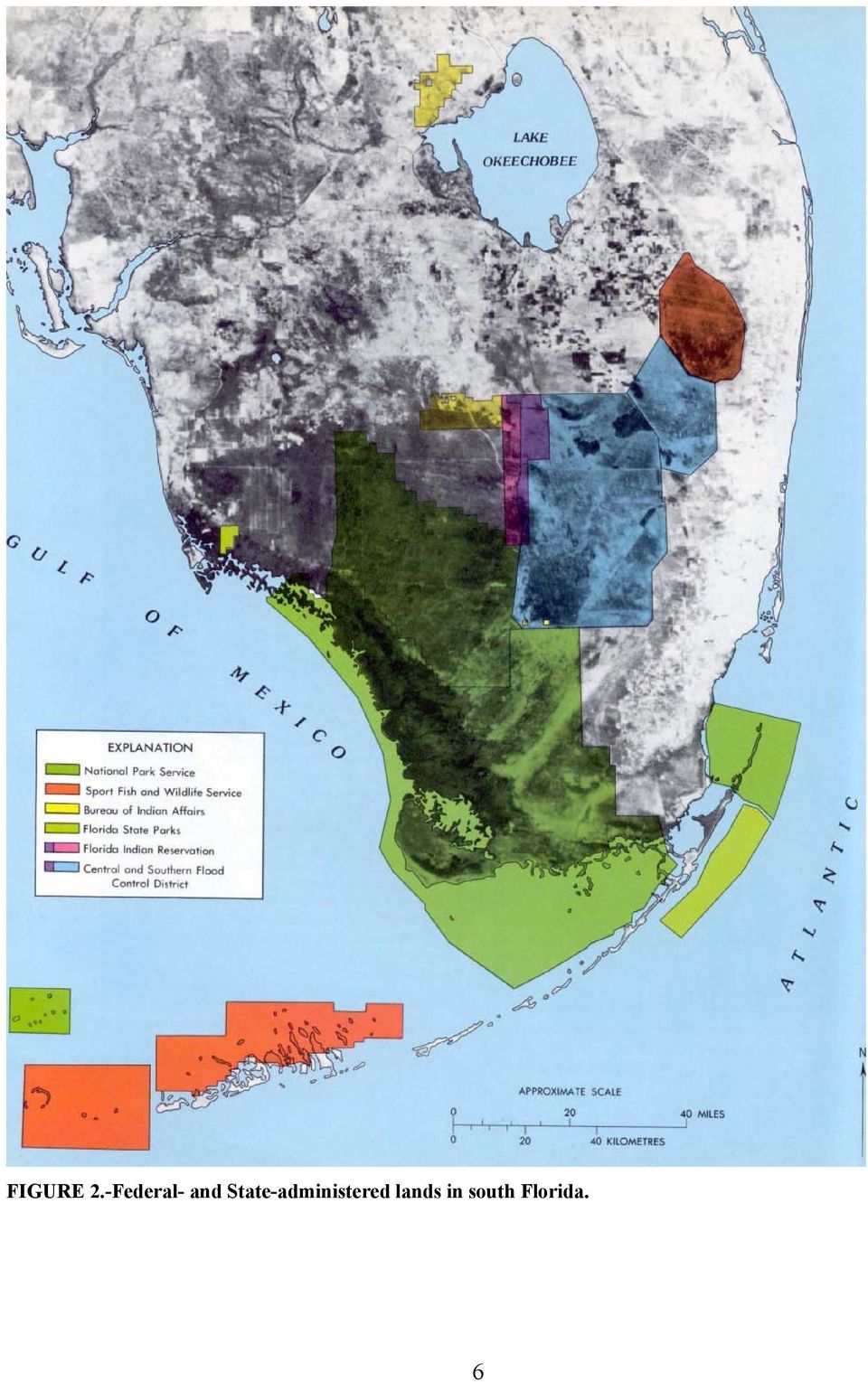
12 History of the South Florida Environmental Study Perhaps it was inevitable that Dade County would propose to build the world's largest airport complex. Such a complex would serve the tourist industry, which in 1970 provided nearly 51.1 billion to the economy of the area (Davis, 1972). Businessmen for many years have advocated a policy of expanding tourism that naturally would require enlarging the aviation center serving south Florida. As an alternative to enlarging the existing aviation center, the Dade County Port Authority began a search for a suitable location for a jet training facility late in The immediate need to supply a jet training facility, coupled with the outlook for additional traffic, suggested to the business community a need to create a large aviation complex to serve all south Florida. By September 1968, the Port Authority selected a 101-km 2 (39-mi 2 ) site in the Big Cypress Swamp shown in figure 1. This site, bounded on the north and west by cypress forest and swamps, was 10 km (6 mi) north of the Everglades National Park and adjoined Conservation Area 3 of the Central and Southern Florida Flood Control District (FCD). The Port Authority authorized purchase and began construction in September At the time of the Port Authority's decision there were at least three strong environmental concerns in south Florida: (1) Protection of Everglades National Park; (2) increased interest in public acquisition of the Big Cypress Swamp; and (3) mounting resistance to uncontrolled urban growth. The jetport issue soon became a national issue. On February 28, 1969, the FCD called for public debate on a jetport in the Big Cypress Swamp. The U.S. Department of the Interior had strong interests in the region because of its responsibility for federally administered lands, as did the State of Florida for State-administered lands (fig. 2). The Department of the Interior interests had led, several years earlier, to the formation of a work group to informally study environmental problems; this group formulated most of the questions. The consensus of the meeting was 4 that studies would be required to obtain the information needed to answer the questions asked for the Port Authority. On May 19, 1969, in West Palm Beach, the FCD called a second meeting wherein spokesmen for the Department of the Interior stated that the information seemed inadequate to make a judgment on the compatibility of the jetport with the ecology of south Florida. During the early part of 1969, the jetport issue received national coverage in newspapers and magazines and on television. Senator Henry Jackson announced that on June 3 he would convene a session of the Senate Committee on Interior and Insular Affairs to hear testimony on south Florida's water supply, environmental pollution, and jet airport problems of the Everglades. On June 2 the Secretary of the Interior, Walter J. Hickel, established a select committee to investigate the ecological impact of the jetport and to deliver by August its findings and recommendations. The Federal Government had now committed itself to help resolve the jetport issue. The select committee's report, known as the "Leopold Report" (Leopold and others, 1969), stated that the proposed jetport would lead to drainage and development of the eastern part of the Big Cypress Swamp, which in turn would cause permanent alteration of the south Florida ecosystem, including the Everglades National Park. The report analyzed the ecology and functioning of the ecosystem and the airport plans for development and found that the proposed development was incompatible with the surrounding ecology. These findings and those from other reports (Freiberger, 1972; Klein, 1972; Klein and others, 1970; Little and others, 1970; Natl. Acad. Sci. Eng., 1970; OVERVIEW, 1969; and Stephens, 1969) meant that the Department of the Interior and probably the Department of Transportation would not approve any further construction of the jetport. This put the Dade County Port Authority in the position of finding a new jetport site. 4

13 FIGURE 1.-Map of south Florida showing features mentioned in the report. 5

14 FIGURE 2.-Federal- and State-administered lands in south Florida. 6
15 FIGURE 3.-Chronology of the South Florida Environmental Project. The Federal Government, however, through the Federal Aviation Agency, acknowledged the urgent need of Dade County for a new and larger airport, and agreed to help in the location and purchase of such an airport. This agreement was called the Everglades Jetport Pact. As part of the pact, the Federal Government allowed the use of the existing Big Cypress jet training facility until an acceptable jetport site could be purchased. In addition, each party to the agreement had certain obligations. Dade County agreed to restrict the size of the existing training facility and to provide for ecologically safe operations. The State of Florida also agreed to assist the county in finding a new site, but would provide little financial assistance for the training facility or for additional service roads. The Federal Government promised to draw up reasonable site-selection criteria for any future site, to monitor the ecological impact of the jet training facility, to provide recommendations for land use in the Big Cypress Swamp, and to undertake an ecological study of the region. When the pact was signed on January 16, 1970, the Department of the Interior assumed responsibility for providing the background ecological information required to answer the questions asked for the Dade County Port Authority a year earlier. In order to meet the Department of the Interior's obligations in the Everglades Jetport Pact, the Secretary of the Interior ordered on March 9, 1970, the formation of the South Florida Environmental Project. The Director of the National Park Service was designated as the chairman, and the Park Service was chosen to coordinate the project and meet the agreements of the pact. The National Park Service, Geological Survey, Bureau of Sport fisheries and Wildlife, Bureau of Outdoor Recreation, Bureau of Indian Affairs, Environmental Protection Agency, and the National Marine Fisheries Service were asked to contribute services and representatives. These agencies had four main tasks: (1) To establish ecological criteria for any future jetport site; (2) to monitor the environment around the existing jet training facility in the Big Cypress Swamp; (3) to provide a land-use plan for the Big Cypress Swamp; and (4) to organize an ecological study of south Florida. The chronology of the South Florida Environmental Project is shown in figure 3. The immediate job of the project was to obtain background information on environmental conditions around the existing training facility in the Big Cypress Swamp. The Geological Survey assumed responsibility for monitoring the water quality within the facility while the Environmental Protection Agency monitored water quality in the surrounding area. 7

16 The project staff began to draw up jetport site selection criteria. The stated purpose of the criteria was to eliminate conflicts over the selection of a jetport site by providing the Port Authority with ecological guidelines acceptable to the Federal Government. The criteria were sent to the Port Authority on July 16, Thereafter a site-review team, consisting of five members, one of whom was the coordinator of the South Florida Environmental Project in Miami, was to select potential sites and to judge their suitability on the basis of these criteria. When the review team makes its final selection, the Department of the Interior has agreed to examine in depth the site selected and to decide on its acceptability. After criteria had been established, the South Florida Environmental Project concentrated on providing a land-use plan for the Big Cypress Swamp. The Department of the Interior released this plan in April 1971, and the South Florida Environmental Project was then free to organize an ecological study of south Florida. Subsequently, Congress passed legislation in 1974 establishing the Big Cypress Swamp as a national preserve, part of the National Park System (P.L ), thus in effect creating a freshwater reserve for the south Florida region. A total of 230,679 ha (570,000 acres), originally thought to he in about 30,000 ownerships but presently known to constitute 8 closer to 70,000 parcels of land, were to be acquired by the National Park Service over a period of 6 years from passage of the act, using $116 million authorized by Congress and $40 million of donated funds that the State of Florida had previously appropriated for this project. For the ecological study of south Florida, it was decided early in 1971 that each participating agency would submit a plan for studies that fell within each agency's expertise. Studies that could not be done by available agency personnel would be contracted to non-federal individuals and groups. At the end of 3 years, reports on 51 studies were completed. The individual studies were originally designed to answer many questions about the ecology of south Florida that had been asked early in the jetport controversy. Since the beginning of the project, however, new questions have been posed. To provide some of the answers to new questions, the project was extended to include a second phase, a definition of "the system of man and nature in south Florida" (fig. 3). Phase two is based on Study No. 1 of the 51 separate studies that constituted phase one. It involves the identification and "tracking" of all energy inputs, storages, and flows in the south Florida ecosystems, now so inextricable a mix of natural and human-imported energies. It is a combination of field research, storage and flow models, and computerized projections of possible futures based on different sets of conditions that could affect the existing system of man and nature in south Florida. The analysis is to be done at three levels: regional, county, and natural ecosystems. 8

17 South Florida as a regional system of man and nature The early ecosystem Before 1900 south Florida was a vast wilderness of bays, marshes, swamps, pine forests, and prairies. Each of these natural features was defined by physical and chemical conditions of the land, by climate, and by representative plants, animals, and microbes, which together constituted an ecosystem. Each ecosystem was sustained by sunlight, wind, rain, nutrients, and along the coast by tides and currents. Each, however, was not isolated, but was dependent on nearby ecosystems for some of its nutrients, water, or wildlife. Freshwater runoff, for example, nourished the interior marshes and carried needed nutrients to the bays. Each of the interdependent ecosystems, then, was a subsystem of the regional ecosystem. Ecosystems evolve in geologic time. The living components adapt to one another and to the nonliving environment. If climate and other environmental conditions remain relatively stable, ecosystems tend toward steady-state or climax conditions. In south Florida, warm weather and abundant freshwater and sunlight over the last few thousand years allowed relatively stable and biologically productive ecosystems to develop. The waters of the region abounded with fish and other aquatic animals, and these in turn supported large numbers of reptiles, birds, and mammals. Indians came into the region more than 2,000 years ago but had virtually disappeared by They were mostly coastal dwellers and relied primarily on fish and shellfish, supplemented with wild game and wild plants. During the 1800's the Seminole Indians were driven into south Florida where they developed a way of life compatible with the ecosystem. The Seminoles were an agricultural people, but in south Florida they supplemented farming with hunting. Gardens were kept, but because of the scarcity of dry land they were limited (Tebeau, 1973). Less than 300 Seminoles were living in the region (Kersey, 1973) in the late 1800's. Their general way of life was disrupted during the 1900's by modifications made to the ecosystem. The changing system - population growth and land-use changes After 1900 men came in increasing numbers to south Florida and began to modify the ecosystem. Areas were drained for farming; bay-front areas were filled; and trees were removed. All this activity required additional sources of energy and material other than those available locally, so machinery, money, and fuel were brought into south Florida. The south Florida ecosystem that had developed over thousands of years gave way to a new three-part ecosystem which incorporated an agricultural component, an urban component, and a component derived from the natural ecosystem. These Components are interrelated through the flow of energy and resources. The agricultural and urban systems rely on the remaining natural systems to provide for the commodities and free services of land, water, and oxygen production. These are needed for recycling nutrients, dispersing and detoxifying pollutants, retaining biological diversity, and producing fish and wildlife. If the natural systems are reduced, the services they once provided free must be provided by an energy subsidy, which is often costly. (A further discussion of systems ecology and ecological modeling is given in Appendix I.) 9

18 Remnants of the pristine ecosystems... A tranquil lake in the Big Cypress Swamp... Scrub cypress in early morning... 10

19 Contrast with... A modern urban profile in Miami... Outdoor recreation, which is largely dependent on the remaining natural systems and their services, is an important component of the south Florida economy and lifestyle. The subtropical coastal environment is conducive to year-round tourism and outdoor recreation such as swimming, fishing, boating, and surfing, which contribute substantially to the economy of the region (U.S. Bur. Outdoor Recreation, 1973). Much of the land suitable to meet the growing population pressures has already been developed. Lands remaining often require dredge and fill, additional drainage, or other types of land preparation to make them habitable. Such activities are usually destructive to natural systems (Birnhak and Crowder, 1974). The temporal and spatial distribution of water may be considered the primary ecological factor in the south Florida regional ecosystem, particularly as it relates to man and his role in the system. The source of freshwater is rainfall that is temporarily stored in Lake Okeechobee, the Big Cypress Swamp, the conservation areas, Everglades National Park, and the shallow aquifers. Each of the storages is directly or indirectly connected to the sea, which can be considered the sink of the freshwater system. Water is transported throughout the hydrological system by canals, rivers, creeks, sloughs, sheet flow, and underground flow and through the air as water vapor. Recent dry-season water deficiencies are linked to a n expanding population, which requires diversions of water from the natural and agricultural systems. The agricultural systems also depend on an adequate water supply, without which lower productivity results. Agricultural and urban systems require an input of energy beyond that supplied naturally. Most of this energy is imported as fossil fuel or as a fossil-fuel product. For example, farmers not only use energy (fuel) directly for tractors but also indirectly in farm machinery, pesticides, and fertilizers that require energy for their production. modern urban societies, in particular, require large inputs of outside energy to build and maintain their complicated structures of transportation, schools, laws, communication networks, buildings, and public services. As cities grow, so do energy requirements; it these are not met, stress occurs and the quality of life deteriorates. 11
. Much of the land suitable to meet the growing population pressures has already been developed.")
20 FIGURE 4.-Flow of energy in the south Florida regional ecosystem. In recent years urban growth in south Florida has been rapid. Population increase from slightly less than 0.5 million in 1940 to 1.5 million in If present trends continue, by 2000 south Florida would have more than 4.4 million residents, or about an 80-percent increase from As the permanent and visiting population increases, more services such as parks, schools, utilities, and transportation are needed. As a result, the cost per capita to supply basic needs often increases, and it becomes increasingly difficult and expensive to furnish these services without disruptive effects. Because of generally unplanned growth, south Florida has an increasing number of socioeconomic environmental problems. Land zoning has been relatively ineffective in regulating growth patterns because it has been based on political, rather ecological, boundaries and on short-term economic benefits. The problems related to growth can be expected to increase and intensify unless growth patterns change and long-range land-use planning is implemented. A regional land-use plan with enforcement provisions is one way to regulate growth and development. Such a plan requires analysis of complex social, economic, and environmental factors. Systems analysis provides a method for generating a plan of this type. In south Florida the foundation has been laid for such an analysis using ecosystem models that simulate the energy sources, storages, and flows in the region. 12

21 Ecosystem models as an approach to resource management Man and nature interact to form a system of interdependent and interconnected parts. The study of this system is called systems ecology. Unlike some other branches of science that describe change as an effect caused by one part acting upon another part, systems ecology describes changes as the interaction of parts. Models are useful to visualize and analyze such systems (Appendix I). Systems ecology and ecological modeling concepts were used in the south Florida study to evaluate environmental problems (Lugo and others, 1971, 1973; Bayley and Odum, 1971; and Carter and others, 1973). Most of the ecological models presented in this report are qualitative. However, in phase 2 of the study, being done by the University of Florida's Center for Wetlands, quantitative data are used in the models to predict changes in the systems under different management alternatives. South Florida is a large and complex mixture of subsystems influenced to varying degrees by man. The subsystems interconnect by energy pathways and form a regional ecosystem as shown in figure 4. The energy sources that drive the system include sun, rain, wind, waves, tides, freshwater, nutrients, fossil fuel, food, manufactured goods, people, and capital. The energy-fixing components (organic producers) include the plant biomass in the Big Cypress Swamp, the Everglades, the mangroves, the estuaries, reefs, and bays and on the agricultural land. Consumers, which convert this biomass into food and which also transform natural energy into power or capital, include wildlife, tourists, residents, machines, buildings, and others. The energy-fixing systems are linked to and provide the basic support for the urban system. The urban and the agricultural systems, however, are highly subsidized by and dependent on fossil fuels and fossil-fuel products. Although the conceptual diagram shown in figure 4 is informative and led to the preceding generalizations, actual resource planning requires information obtained from more detailed. specific site studies to be effective. The systems ecology approach for resource planning has been applied in DeSoto, Charlotte, and Lee Counties during a pilot study by the Florida Coastal Coordinating Council and the University of Florida (Wetterqvist and others, 1972). In that study, subsystems were classified and energy flows diagrammed to produce a model from which tentative suggestions were made for planning in the southwest Florida coastal zone. Another example is a study of the urban systems of Lee County (Brown and Genova, 1974) in which detailed recommendations were made. 13
22 A model of the regional ecosystem, such as that shown in figure 4, provides an overview and can help in identifying deficiencies in the information needed for formulating specific land-use recommendations, but it lacks the detail and quantification needed for resource planning and decisions. By breaking down the regional ecosystem into subsystems, more detail is provided. In this report the regional ecosystem is divided as follows: Freshwater and terrestrial ecosystems: Canals and lakes Ponds and sloughs Sawgrass marshes Wet prairies Pine forests Cypress forests Mixed swamp forests Bay heads Hardwood hammocks Palmetto and dry prairies Coastal ecosystems: Sandy beaches Mangrove and salt marshes Shallow estuaries and bays The reef tract Man-dominated ecosystems: Agricultural Urban Because of the special importance of water in south Florida, a separate section of this report devoted to hydrologic systems discusses problems concerning water quantity and quality. To be most useful in resource management, systems models should be quantitative; they not only should show relationships between energy sources, storages, producers, and consumers but should show the magnitude of these relationships as well. For example, computer simulation of a sawgrass marsh model indicated that high inputs of phosphorus would result in increased transpiration and fires in the marsh (Bayley and Odum, 1971). As part of the south Florida study, quantitative data on the regional ecosystem are being amassed by a team at the University of Florida's Center for Wetlands. With these data and with the models developed in this study, computer simulation will be used to predict the effects of various management alternatives on the south Florida ecosystem. 14
23 Ecosystems of south Florida Freshwater and terrestrial ecosystems The natural freshwater swamp, marsh, and terrestrial systems of south Florida whose extents are shown in figure 5 lie within five physiographic regions (fig. 6): (1) the Everglades; ( 2 ) the Atlantic Coastal Ridge; (3) the Eastern Flatlands; (4) the Western Flatlands; and (5) the Big Cypress Swamp (Davis, 1943). The Everglades and the Big Cypress Swamp are predominantly freshwater marsh and swamp systems. The Atlantic Coastal Ridge is mostly terrestrial. The Flatlands are composed of swamp, marsh, and terrestrial systems. All these natural systems are affected to some degree by man. Relations between systems A seasonal abundance of freshwater in south Florida has favored the development of a number of swamp, marsh, and terrestrial systems. Each is controlled, in part, by the moisture in the soil or by the duration and the depth of inundation; these in turn are determined by the amounts and frequency of rainfall, the infiltration capacity of the soil and underlying bedrock, and by land elevation. High areas that are seldom flooded usually support pine forests, hardwood hammock forests, or grassland systems. Low areas that are flooded part of the year are wetlands, which include prairies, marshes, or swamp systems (fig. 7). The hydrologic environment, however, is not the sole control on a system. Fire, tropical storms, frost and cold weather, saltwater invasion, and man also affect the systems. Freshwater is a key environmental factor in that it not only affects a system directly but it also affects other controlling environmental factors such as fires, soil, temperature, and saltwater invasion. Freshwater is also a key factor manipulated by man. Water, sunlight, and nutrients are essential ingredients for organic plant production, which sustains each system. Marsh and swamp systems require seasonal flooding to maintain adequate levels of production. In the marshes, herbaceous plants and periphyton are the primary producers; in the swamps, trees are the primary, producers. Terrestrial plants, which do not tolerate much flooding, rely mainly on rainfall and soil moisture. P1ant production sustains each System by providing the food for the two other major components of a system: the animals and the saprophytes (bacteria, yeast, fungi). Many plants and animals are adapted to and dependent on the seasonal fluctuations of water level. During wet seasons, aquatic-plant production abounds; small crustaceans and fish feed on the growing plants or plant remains. With abundant food and space, aquatic-animal populations increase. As water levels decline during the dry season, the small aquatic animals are forced to concentrate in scattered ponds, tributary creeks, and sloughs. The concentrated biomass then becomes a rich source of food for larger fish, alligators, snakes, birds, and mammals. Rainfall is the ultimate source of water in south Florida. It is maximal over the Atlantic Coastal Ridge (1,523 mm/yr or 60 in/yr) and decreases incrementally away from the ridge. The annual rainfall pattern, however, does not correlate with the physiographic regions and their ecological systems. These regions and systems are more closely correlated with the distribution of water, soil type, and land elevation. Under ideal conditions, systems undergo orderly, successional changes until a relatively stable situation is reached in which a system is in equilibrium with its climatic environment and is capable of self-perpetuation as long as the climate does not change radically. The stable system is called a climax; antecedent unstable ones are subclimax. Each system in this successional change has its own species, organization, and conditions, and these are different from all others. In addition, each system creates the habitat and conditions for its successor. The concept of orderly change ending in a climax has been applied mainly to vegetation but is generally applicable to ecosystems, which include biological components as well as the physical environment. 15
Ecosystem Services in the Greater Houston Region. A case study analysis and recommendations for policy initiatives
 Ecosystem Services in the Greater Houston Region A case study analysis and recommendations for policy initiatives Ecosystem Services Ecosystems provide services through their natural processes that we
Policy & Management Applications of Blue Carbon. fact SHEET
 Policy & Management Applications of Blue Carbon fact SHEET Policy & Management Applications of Blue Carbon Coastal Blue Carbon - An Important Wetland Ecosystem Service Coastal Blue Carbon refers to the
Communities, Biomes, and Ecosystems
 Communities, Biomes, and Ecosystems Before You Read Before you read the chapter, respond to these statements. 1. Write an A if you agree with the statement. 2. Write a D if you disagree with the statement.
The Everglades & Northern Estuaries; St. Lucie River Estuary, Indian River Lagoon & Caloosahatchee Estuary. Water Flows & Current Issues
 The Everglades & Northern Estuaries; St. Lucie River Estuary, Indian River Lagoon & Caloosahatchee Estuary Water Flows & Current Issues Florida Governor Rick Scott August 20, 2013 Upper Chain of Lakes
GAO COMPREHENSIVE EVERGLADES RESTORATION PLAN. Additional Water Quality Projects May Be Needed and Could Increase Costs
 GAO United States General Accounting Office Report to the Chairman, Subcommittee on Transportation and Infrastructure, Committee on Environment and Public Works, U.S. Senate September 2000 COMPREHENSIVE
Appendix B: Cost Estimates
 Appendix B: Estimates This appendix presents the estimated costs of the monitoring and supplemental research components presented in Section 3 of this document. A 20% quality assurance and quality control
Chapter 3 Communities, Biomes, and Ecosystems
 Communities, Biomes, and Ecosystems Section 1: Community Ecology Section 2: Terrestrial Biomes Section 3: Aquatic Ecosystems Click on a lesson name to select. 3.1 Community Ecology Communities A biological
Briefing Paper on Lower Galveston Bay and Bayou Watersheds Lower Bay I: Armand Bayou to Moses Lake and Adjacent Bay Waters
 Briefing Paper on Lower Galveston Bay and Bayou Watersheds Lower Bay I: Armand Bayou to Moses Lake and Adjacent Bay Waters Jim Lester, PhD. and Lisa Gonzalez Houston Advanced Research Center Galveston
4.2 Buena Vista Creek Watershed
 Buena Vista Creek Watershed 4.2 Buena Vista Creek Watershed Watershed Overview The Buena Vista Creek Watershed is the fourth-largest system within the Carlsbad Hydrologic Unit. The watershed extends approximately
WONDERFUL, WATERFUL WETLANDS
 WONDERFUL, WATERFUL WETLANDS OBJECTIVES The student will do the following: 1. List characteristics of wetlands. SUBJECTS: Science, Language Arts TIME: 60 minutes 2. Describe the functions of a wetland.
PROCEDURE. See: Great Lakes Coastal Wetlands (http:// www.miseagrant.umich.edu/wetlands/index.html)
") Activity: Students review a selection of career profiles and play a lively classroom game to find out more about marine and aquatic science professionals. Grade Level: 4-8 Subjects: Science, social studies
Activity: Students review a selection of career profiles and play a lively classroom game to find out more about marine and aquatic science professionals. Grade Level: 4-8 Subjects: Science, social studies
Restoring America s Everglades Progress and Next Steps for Restoring a Treasured Landscape and Sustaining a Way of Life
 Restoring America s Everglades Progress and Next Steps for Restoring a Treasured Landscape and Sustaining a Way of Life Credits: Carlton Ward, Jr./ CarltonWard.com There are no other Everglades in the
The St. Lucie River is 35 miles long and has two major forks, the North Fork and the South Fork. In the 1880s, the system was basically a freshwater
 The St. Lucie River is 35 miles long and has two major forks, the North Fork and the South Fork. In the 1880s, the system was basically a freshwater stream flowing into the Indian River Lagoon. An inlet
Restoring Ecosystems. Ecosystem Restoration Services
 Restoring Ecosystems Ecosystem Restoration Services 2 Ecosystem Restoration Services AECOM s integrated approach sciencebased planning, with innovative design and execution delivers sustainable and cost-effective
COMPREHENSIVE PLAN SECTION B, ELEMENT 4 WATER RESOURCES. April 20, 2010 EXHIBIT 1
 COMPREHENSIVE PLAN SECTION B, ELEMENT 4 WATER RESOURCES April 20, 2010 EXHIBIT 1 ELEMENT 4 WATER RESOURCES TABLE OF CONTENTS 4.1 INTRODUCTION 4.2 GOALS AND POLICIES 4.2.A General Goals and Policies 1 4.2.B
Ecosystems and Food Webs
 Ecosystems and Food Webs How do AIS affect our lakes? Background Information All things on the planet both living and nonliving interact. An Ecosystem is defined as the set of elements, living and nonliving,
AQUATIC ECOSYSTEMS & BIOMES
 AQUATIC ECOSYSTEMS & BIOMES A) Name three general types of aquatic ecosystems and describe the salinity for each. Give an example for each. 1) 2) 3) B) MATCHING In the space provided, write the letter
Key Idea 2: Ecosystems
 Key Idea 2: Ecosystems Ecosystems An ecosystem is a living community of plants and animals sharing an environment with non-living elements such as climate and soil. An example of a small scale ecosystem
How To Plan A Buffer Zone
 Backyard Buffers Protecting Habitat and Water Quality What is a buffer? A buffer (also called a riparian buffer area or zone) is the strip of natural vegetation along the bank of a stream, lake or other
THE ECOSYSTEM - Biomes
 Biomes The Ecosystem - Biomes Side 2 THE ECOSYSTEM - Biomes By the end of this topic you should be able to:- SYLLABUS STATEMENT ASSESSMENT STATEMENT CHECK NOTES 2.4 BIOMES 2.4.1 Define the term biome.
NATURAL RESOURCE RESTORATION LESSON PLAN Fix It!
 NATURAL RESOURCE RESTORATION LESSON PLAN Fix It! Theme Repairing Damaged Resources Links to Overview Essays and Resources Needed for Student Research http://oceanservice.noaa.gov/education/corals http://oceanservice.noaa.gov/topics/coasts/restoration/
Phosphorus. Phosphorus Lake Whatcom Cooperative Management. www.ecy.wa.gov/programs/wq/nonpoint/phosphorus/phosphorusban.html
 Phosphorus Phosphorus Brochure Lake Whatcom Cooperative Management Reducing Phosphorus Website Washington State Department of Ecology www.ecy.wa.gov/programs/wq/nonpoint/phosphorus/phosphorusban.html Nutrients
Recognizing Wetlands. For additional information contact your local U.S. Army Corps of Engineers office. Pitcher plant.
 US Army Corps of Engineers For additional information contact your local U.S. Army Corps of Engineers office. 1998 Edition Recognizing Wetlands Pitcher plant The information presented here will help you
Ecological Restoration of a Brackish Marsh at Parcel 11, Estate Carolina, St. John
 Ecological Restoration of a Brackish Marsh at Parcel 11, Estate Carolina, St. John Gary Ray, Ph.D. Virgin Forest Restorations For Coral Bay Community Council Aerial of Parcel 11 Brackish Marsh Ecological
GLOBAL CIRCULATION OF WATER
 Global Circulation of Water MODULE - 8A 27 GLOBAL CIRCULATION OF WATER More than three-fourths of the earth s surface is covered by water. Water is an odorless, tasteless, substance than can naturally
GLOSSARY OF TERMS CHAPTER 11 WORD DEFINITION SOURCE. Leopold
 CHAPTER 11 GLOSSARY OF TERMS Active Channel The channel that contains the discharge Leopold where channel maintenance is most effective, sediment are actively transported and deposited, and that are capable
Susan Iott U. S. General Accounting Office. Restoration of the South Florida Ecosystem
 Susan Iott U. S. General Accounting Office Restoration of the South Florida Ecosystem Presented at The Aspen Global Change Institute June 5-10, 2003 Summer Science Session I Learning from Regions: A Comparative
RESTORATION AND ENHANCEMENT OF SOUTHERN CALIFORNIA LAGOONS
 RESTORATION AND ENHANCEMENT OF SOUTHERN CALIFORNIA LAGOONS by Hany Elwany, Ph.D. Scripps Institution of Oceanography Headwaters to Oceans Conference 25 October 2003 CE Ref #03-22 San Diego County Lagoons
Aquatic Biomes, Continued
 Aquatic Biomes, Continued Introduction Extent of Marine biomes Issues & challenges Factors influencing distribution Dynamics in time & space Depth Tour of marine biomes Issues (by biome) Freshwater biomes
Michigan Wetlands. Department of Environmental Quality
 Department of Environmental Quality Wetlands are a significant component of Michigan s landscape, covering roughly 5.5 million acres, or 15 percent of the land area of the state. This represents about
AP ENVIRONMENTAL SCIENCE 2010 SCORING GUIDELINES
 AP ENVIRONMENTAL SCIENCE 2010 SCORING GUIDELINES Question 4 (a) Based on the rate cited above, calculate the expected increase in sea level, in meters, during the next 50 years. One point can be earned
The concepts developed in this standard include the following: Oceans cover about 70% of the surface of the Earth.
 Name Date Grade 5 SOL 5.6 Review Oceans Made by SOLpass - www.solpass.org solpass100@comcast.net Reproduction is permitted for SOLpass subscribers only. The concepts developed in this standard include
Multiple Species Conservation Program County of San Diego. A Case Study in Environmental Planning & The Economic Value of Open Space
 Multiple Species Conservation Program County of San Diego A Case Study in Environmental Planning & The Economic Value of Open Space Amy M. Fox Land Use Law Case Study Autumn Semester, 1999 Multiple Species
Communities, Biomes, and Ecosystems
 Chapter Test A CHAPTER 3 Communities, Biomes, and Ecosystems Part A: Multiple Choice In the space at the left, write the letter of the term or phrase that best answers each question Part B: Matching 1
NOTE TO TEACHER: It is appropriate to introduce the mitochondria (where energy is made) as a major structure common to all cells.
 as a major structure common to all cells.") 5.2.1 Recall the cell as the smallest unit of life and identify its major structures (including cell membrane, cytoplasm, nucleus, and vacuole). Taxonomy level: 1.1 and 1.2-A Remember Factual Knowledge
5.2.1 Recall the cell as the smallest unit of life and identify its major structures (including cell membrane, cytoplasm, nucleus, and vacuole). Taxonomy level: 1.1 and 1.2-A Remember Factual Knowledge
Name Date Hour. Plants grow in layers. The canopy receives about 95% of the sunlight leaving little sun for the forest floor.
 Name Date Hour Directions: You are to complete the table by using your environmental text book and the example given here. You want to locate all the abiotic (non-living) and biotic (living) factors in
WILLOCHRA BASIN GROUNDWATER STATUS REPORT 2009-10
 WILLOCHRA BASIN GROUNDWATER STATUS REPORT 2009-10 SUMMARY 2009-10 The Willochra Basin is situated in the southern Flinders Ranges in the Mid-North of South Australia, approximately 50 km east of Port Augusta
QUESTIONS AND ANSWERS WATERS OF THE U.S. PROPOSAL
 QUESTIONS AND ANSWERS WATERS OF THE U.S. PROPOSAL Key Background Congress enacted the modern Clean Water Act in 1972 to address pollution entering the nation s waters to complement statutes such as the
Sec. 22a-1a page 1 (4-97)
") Department of Environmental Protection Sec. 22a-1a page 1 (4-97) TABLE OF CONTENTS Connecticut Environmental Policy Act Definitions... 22a-1a- 1 Determination of sponsoring agency.... 22a-1a- 2 Determination
Department of Environmental Protection Sec. 22a-1a page 1 (4-97) TABLE OF CONTENTS Connecticut Environmental Policy Act Definitions... 22a-1a- 1 Determination of sponsoring agency.... 22a-1a- 2 Determination
Biomes An Overview of Ecology Biomes Freshwater Biomes
 Biomes An Overview of Ecology Ecology is the scientific study of the interactions between organisms and their environments. Ecology can be divided into four increasingly comprehensive levels: Organismal
Introduction to Natural Resource Damage Assessment
 Introduction to Natural Resource Damage Assessment Topics Overview Legal: Laws and Regulations NRDA Process Scaling Injuries and Restoration Restoration in the Arctic Summary 2 1 Top Three Things to Know
3. The submittal shall include a proposed scope of work to confirm the provided project description;
 QIN Shoreline Master Program Project Summary The Shoreline Master Program (SMP) development process for the Quinault Indian Nation (QIN) includes the completion of inventory and analysis report with corresponding
Climate Change Long Term Trends and their Implications for Emergency Management August 2011
 Climate Change Long Term Trends and their Implications for Emergency Management August 2011 Overview A significant amount of existing research indicates that the world s climate is changing. Emergency
Curt Kerns, M.S., R.P.Bio., C.F.S. WetlandsPacific Corp. 250-722-7117 www.wetlandspacific.com
 Curt Kerns, M.S., R.P.Bio., C.F.S. WetlandsPacific Corp. 250-722-7117 www.wetlandspacific.com Presentation Historical perspectives Present perspectives How wetlands function Examples of natural wetlands
SPA Annual Report for 2002 September, 2003 Montgomery County Department of Environmental Protection Page 125. Evaluation and Recommendations
 Montgomery County Department of Environmental Protection Page 125 Evaluation and Recommendations Monitoring efforts in the Special Protection Areas continue to provide the kind of information needed to
WATER AND DEVELOPMENT Vol. II - Types Of Environmental Models - R. A. Letcher and A. J. Jakeman
 TYPES OF ENVIRONMENTAL MODELS R. A. Letcher and A. J. Jakeman Centre for Resource and Environmental Studies, The Australian National University, Australia Keywords: environmental models, environmental
Wetland Vocabulary Organizer
 Wetland Vocabulary Organizer Vocabulary Word Definition Wetland Picture Species Nutrients Sediment Groundwater Habitat Vocabulary Word Wetland Wetland Vocabulary Organizer Key Definition is an area that,
Everglades Restoration Progress
 S O U T H F L O R I D A W A T E R M A N A G E M E N T D I S T R I C T Everglades Progress JANUARY 2016 BACKGROUND: America s Everglades was once a vibrant, free-flowing River of Grass, extending from the
AN INITIATIVE TO IMPROVE
 L OW E R C A R M E L R I V E R A N D L AG O O N F L O O D P L A I N R E S TO R AT I O N A N D E N H A N C E M E N T P R O J E C T AN INITIATIVE TO IMPROVE FLOOD PROTECTION RESTORE AND PROTECT RIPARIAN
7.0 Stream Restoration
 7.0 Stream Restoration 7.1 Issue Statements One of the primary concerns of residents in the Bassett Creek watershed is the maintenance of the natural beauty of the creek in residential and recreational
Revising the Nantahala and Pisgah Land Management Plan Preliminary Need to Change the Existing Land Management Plan
 Revising the Nantahala and Pisgah Land Management Plan Preliminary Need to Change the Existing Land Management Plan Throughout the Plan 1. There is a fundamental need for the revised plan to address how
Most informed people realize that cumulative impacts have had
 Welcome to the First Issue of Rivers & Coast! The goal of the new Rivers & Coast newsletter is to keep readers well informed of current scientific understanding behind key environmental issues related
RESTORATION & REVITALIZATION
 RESTORATION & REVITALIZATION Legal preservation has not proved to be sufficient to preserve natural communities. Restoration activities are diverse and includes revitalization of natural communities which
Connecting Science and Management for Virginia s Tidal Wetlands. In this issue...
 In this issue... We review the relationship between science and the management of tidal wetlands in Virginia. The program has evolved over the past four decades to address: E the public benefits provided
Detention Ponds. Detention Ponds. Detention Ponds. Detention Ponds. Detention Ponds. Detention Ponds. CIVL 1112 Detention Ponds - Part 1 1/12
 CIVL 1112 - Part 1 1/12 The water cycle, also known as the hydrologic cycle, describes the continuous movement of water on, above and below the surface of the Earth. The water cycle, also known as the
WATER: ENVIRONMENTAL SCIENCE Syllabus
 WATER: ENVIRONMENTAL SCIENCE Syllabus Course Title Water: Environmental Science Course Description Central to all ecosystems, water is essential to life as we know it. It shapes our planet on every level,
ENVIRONMENTAL CHANGES
 reflect How do you respond to environmental changes? Maybe you wear different types of clothes in different seasons. Maybe you only ride your bike during certain times of the year. What if you moved to
Dawn Reis Ecological Studies. www.ecologicalstudies.com
 Dawn Reis Ecological Studies www.ecologicalstudies.com Laguna Salada Sharp Park s Federal & State Protected San Francisco Garter Snake (Thamnophis sirtalis tetrataenia) and California Red-legged Frog (Rana
Efficient Food Requirements of the Whooping Cranes
 Evaluation of factors affecting food abundance and time-activity budgets of whooping cranes at Aransas National Wildlife Refuge R. Douglas Slack, William E. Grant, Todd M. Swannack, and Jeffery R. Wozniak
4. Priority Areas of Conservation
 4. Priority Areas of Conservation A. SIGNIFICANT RESOURCE AREAS This Open Space and Farmland Plan identifies the key issues facing open space and agricultural resources in the Town, highlights the location
Environmental Data Services for Delaware:
 Environmental Data Services for Delaware: Serving Emergency Responders, Planners, and Researchers Network Delaware Day November 6, 2013 Overview Operational Data Services More than just research DEOS and
Protected Area Categories and Management Objectives
 Protected Area Categories and Management Objectives A protected area is defined as: An area of land and/or sea especially dedicated to the protection and maintenance of biological diversity, and of natural
One Major Six Concentrations. Department of Environmental Conservation University of Massachusetts Amherst
 One Major Six Concentrations Natural Resources Conservation Undergraduate Major Department of Environmental Conservation University of Massachusetts Amherst Conserving Earth s biological diversity and
APPENDIX C LIST OF EA RECIPIENTS
 APPENDIX C APPENDIX C LIST OF RECIPIENTS C.1 Federal Agencies Advisory Council on Historic Preservation, Office of Cultural Resources Preservation U.S. Army Corps of Engineers, District Engineer, Regulatory
Pamela Birak, Jordan Lake State Park, Chatham County, NC
 Pamela Birak, Jordan Lake State Park, Chatham County, NC 3 Lakes, Reservoirs, and Ponds Forty-six states, Puerto Rico, and the District of Columbia (collectively referred to as states in the rest of this
RESTORING THE EVERGLADES HIGHLIGHTS OF THE NATIONAL ACADEMIES REPORTS ON EVERGLADES RESTORATION
 T H E S C I E N C E O F RESTORING THE EVERGLADES HIGHLIGHTS OF THE NATIONAL ACADEMIES REPORTS ON EVERGLADES RESTORATION F orida s Everglades, the splendid River of Grass, is like no other place on Earth.
Freshwater Resources and Water Pollution
 Visualizing Environmental Science Freshwater Resources and Water Pollution Chapter 10 Copyright The Importance of Water Life on Earth would be impossible without water All living organisms contain water
South Florida Sea Level Rise Projections and Flood Risk Concerns
 South Florida Sea Level Rise Projections and Flood Risk Concerns MIAMI MIAMI Biscayne Bay Glenn B. Landers, P.E. Planning and Policy Division Jacksonville District EVERGLADES NATIONAL PARK USACE Flood
Environmental Science
 Environmental Science UNIT I: Introduction to Environmental Science The student will demonstrate the ability to use scientific skills necessary to identify and analyze environmental issues. a. Define environmental
Environmental Compliance Questionnaire for National Oceanic and Atmospheric Administration Federal Financial Assistance Applicants
 OMB Approval No.: 0648-0538 Environmental Compliance Questionnaire for National Oceanic and Atmospheric Administration Federal Financial Assistance Applicants Instructions The National Environmental Policy
TOPIC BILL FORMAT CHANGES (underline = additions; strikethrough = deletions) RATIONALE
 RATIONALE") Attachment C: Ecology Recommended Changes The following changes are recommended to clarify elements of the City s updated SMP ITEM SMP Submittal Provision (Cite) TOPIC BILL FORMAT CHANGES (underline =
Attachment C: Ecology Recommended Changes The following changes are recommended to clarify elements of the City s updated SMP ITEM SMP Submittal Provision (Cite) TOPIC BILL FORMAT CHANGES (underline =
Fuels Treatments Reduce Wildfire Suppression Cost Merritt Island National Wildlife Refuge May 2012
 Fuels Treatments Reduce Wildfire Suppression Cost Merritt Island National Wildlife Refuge May 2012 Merritt Island National Wildlife Refuge Where Technology and Nature Intersect Authors Jennifer Hinckley
CAPS Landscape Metrics November 2011
 CAPS Landscape Metrics November 2011 This appendix describes the landscape metrics available in CAPS. These metrics are weighted and combined separately for each community, using the community model listed
Pay Later: The Cost of Inaction. Climate change will have a negative impact on many of the industries that 3500 3000 2500 2000 1500 1000 500 5.
 FACTS CONNECTICUT A M E R I C A N S E C U R I T Y P R O J E C T Pay Now, Pay Later: Connecticut The Environmental Protection Agency estimates that the cost of protecting Connecticut s coast from the potential
South Florida Everglades Ecosystem Restoration Program
 South Florida Everglades Ecosystem Restoration Program Restoration Program and Project Briefings Joint Working Group / Science Coordination Group Meeting April 2, 2014 Howie Gonzales Chief, Ecosystem Branch
2. What kind of energy is stored in food? A. chemical energy B. heat energy C. kinetic energy D. light energy
 Assessment Bank Matter and Energy in Living Things SC.8.L.18.4 1. What is energy? A. anything that takes up space B. anything that has mass C. the ability to conduct current D. the ability to do work 2.
3. Which relationship can correctly be inferred from the data presented in the graphs below?
 1. Recent evidence indicates that lakes in large areas of New York State are being affected by acid rain. The major effect of acid rain in the lakes is (1) an increase in game fish population levels (3)
THE SECRETARY OF THE INTERIOR WASHINGTON
 THE SECRETARY OF THE INTERIOR WASHINGTON ORDER NO. 3336 Subject: Rangeland Fire Prevention, Management and Restoration Sec. 1 Purpose. This Order sets forth enhanced policies and strategies for preventing
Restoring Habitats for Resilient Coastal Economies. A Series of County Initiatives
 for Resilient Coastal A Series of County Initiatives JANUARY 2014 Cover: Sanibel Island in Southeast Florida. for Resilient Coastal This document provides coastal county leaders and coastal managers with
Web of Water. Teacher s Guide Webisode 1 Blue Ridge
 Web of Water Teacher s Guide Webisode 1 Blue Ridge Table of Contents About Blue Ridge.... 3 South Carolina Science Standards.. 4 Discussion Questions.. 10 Knowitall Resources....... 13 Credits..... 14
A Functional Classification System for Marine Protected Areas in the United States
 A Functional Classification System for Marine Protected Areas in the United States The U.S. Classification System: An Objective Approach for Understanding the Purpose and Effects of MPAs as an Ecosystem
Climate Change: A Local Focus on a Global Issue Newfoundland and Labrador Curriculum Links 2010-2011
 Climate Change: A Local Focus on a Global Issue Newfoundland and Labrador Curriculum Links 2010-2011 HEALTH Kindergarten: Grade 1: Grade 2: Know that litter can spoil the environment. Grade 3: Grade 4:
DEPARTMENT OF ENVIRONMENTAL QUALITY Environmental Assessment
 DEPARTMENT OF ENVIRONMENTAL QUALITY Environmental Assessment Water Protection Bureau Name of Project: Applicant: Ueland Land Development LLC Type of Project: Proposed discharge of treated domestic wastewater
33 CFR PART 332 COMPENSATORY MITIGATION FOR LOSSES OF AQUATIC RESOURCES. Authority: 33 U.S.C. 401 et seq. ; 33 U.S.C. 1344; and Pub. L. 108 136.
 33 CFR PART 332 COMPENSATORY MITIGATION FOR LOSSES OF AQUATIC RESOURCES Authority: 33 U.S.C. 401 et seq. ; 33 U.S.C. 1344; and Pub. L. 108 136. Source: 73 FR 19670, Apr. 10, 2008, unless otherwise noted.
Community Workshop 5. Overarching Goals for Machado Lake Ecosystem and Wilmington Drain Multi-Use Projects
 City of Los Angeles Department of Public Works Bureau of Engineering Machado Lake Ecosystem Rehabilitation Project & Wilmington Drain Multi-Use Project Community Workshop 5 February 24, 2009 In association
3.4 DRAINAGE PLAN. 3.4.1 Characteristics of Existing Drainages. 3.4.2 Master Drainage System. Section 3: Development Plan BUTTERFIELD SPECIFIC PLAN
 3.4 DRAINAGE PLAN This section describes the existing onsite drainage characteristics and improvements proposed within this Specific Plan. Following this description, drainage plan development standards
Human Impacts on the World Ocean
 This website would like to remind you: Your browser (Safari 7) is out of date. Update your browser for more security, comfort and the best experience on this site. lesson Human Impacts on the World Ocean
Flood Risk Management
 Flood Risk Management Value of Flood Risk Management Every year floods sweep through communities across the United States taking lives, destroying property, shutting down businesses, harming the environment
Flood Risk Management
 Flood Risk Management Value of Flood Risk Management Value to Individuals and Communities Every year floods sweep through communities across the United States taking lives, destroying property, shutting
SECTION 9 SUMMARY OF COORDINATION, PUBLIC VIEWS AND COMMENTS
 SECTION 9 SUMMARY OF COORDINATION, PUBLIC VIEWS AND COMMENTS This page intentionally left blank. 9.0SUMMARY OF COORDINATION, PUBLIC VIEWS AND COMMENTS 9.1 PUBLIC OUTREACH AND PUBLIC INVOLVEMENT Public
Ch. 15-Restoration Ecology
 Ch. 15-Restoration Ecology Conservation focuses on protecting and maintaining diversity and ecological processes Restoration emphasizes active management to bring back a former state of an ecosystem (
GREAT BARRIER REEF. Climate Change Action Plan
 GREAT BARRIER REEF Climate Change Action Plan 2007 2011 Climate change is now recognised as the greatest long-term threat to the Great Barrier Reef. The Great Barrier Reef is internationally renowned as
Global Water Resources
 Global Water Resources Highlights from assessment activities over the past two decades, which are used to establish present and future water trends, reveal that: 1. Freshwater resources are unevenly distributed,
Regulatory Features of All Coastal and Inland Ecological Restoration Limited Projects
 Eligibility Checklist This Ecological Restoration Limited Project Eligibility Checklist guides the applicant in determining if their project is eligible to file as an Inland or Coastal Ecological Restoration
Green Infrastructure Case Study Template
 Green Infrastructure Case Study Template The aim of the exercise is to provide information on how the elements of the Green Infrastructure Strategy are implemented at national level and to provide case
Lesson Overview. Biodiversity. Lesson Overview. 6.3 Biodiversity
 Lesson Overview 6.3 6.3 Objectives Define biodiversity and explain its value. Identify current threats to biodiversity. Describe how biodiversity can be preserved. THINK ABOUT IT From multicolored coral
Appendix A: Land Protection Plan
 Appendix A: Land Protection Plan In this appendix A.1 Introduction and Purpose A.2 Project Description A.3 Refuge Purposes A.4 Land Acquisition Policy for Urban Refuges A.5 Status of Resources to be Protected
Chapter 18 Introduction to. A f r i c a
 Chapter 18 Introduction to A f r i c a Ch. 18:1 Landforms & Resources 1. Africa s shape & landforms are the result of its location in the southern part of the ancient supercontinent of. Pangaea Over thousands
Wetlands and Climate Change: Considerations for Wetland Program Managers
 Wetlands and Climate Change: Considerations for Wetland Program Managers Association of State Wetland Managers July 2015 1 Wetlands and Climate Change: Considerations for Wetland Program Managers Association
PUZZLING PIPES. Grade Level: 4-6
 PUZZLING PIPES Overview: Students will learn about the various paths that water takes after it is used. They will trace the path of wastewater either through the storm drain system or the sanitary sewer