4. Priority Areas of Conservation
|
|
|
- Frank Ross
- 10 years ago
- Views:
Transcription
1 4. Priority Areas of Conservation A. SIGNIFICANT RESOURCE AREAS This Open Space and Farmland Plan identifies the key issues facing open space and agricultural resources in the Town, highlights the location and importance of these resources, and provides a framework for collaborative efforts for their conservation. The inventory of the existing natural resources, agriculture lands, and open spaces that contribute to the Town s character, as described in Chapter 3, provides the basic environmental data and analysis necessary to make qualified judgments on which areas would provide the greatest benefit and are worthy of closer consideration for conservation. The 2009 Pleasant Valley Town Comprehensive Plan laid the groundwork for land conservation policy in the Town. As part of the Town Plan, three important greenway areas were identified; the Wappinger Creek corridor, the area to the east of the Taconic State Parkway bordering the Town of Washington, and the rural/agricultural areas in the north and west sections of Town. greenway areas, into six Significant Resource Areas (see Exhibit 4.1). These Significant Resource Areas are a synthesis of overlapping layers of important resources and existing land conservation patterns and this Plan recommends that land conservation efforts by the Town should be focused within these areas: 1. Gretna Road / Salt Point Area 2. VanWagner Road Area 3. Wappinger Creek Corridor 4. Traver Road / Drake Road Area 5. Pine Hill Area 6. Taconic East Area Land conservation is already taking root in most of these areas as some large landowners have already recognized the importance of conserving open space. This is evidenced by the more than 500 acres of land, which have been preserved via voluntary private conservation easement agreements. This Plan expands upon the foundation established in the 2009 Town Comprehensive Plan, by providing additional detail on identified greenway areas and their specific environmental and natural resource characteristics. As such, this Plan apportions the three originally identified 61

2 4 Priority Areas of Conservation 62

3 Exhibit 4.1 Significant Resource Areas 63

4 4 Priority Areas of Conservation 1. GRETNA ROAD / SALT POINT AREA Identified as a Greenway Area of the Town by the 2009 Pleasant Valley Comprehensive Plan, the Gretna Road / Salt Point Area traverses most of the north and west sections of Town, in and around the hamlet of Salt Point and along the Gretna Road and Salt Point Turnpike corridors. Important conservation goals in this area include preservation of working farms (agricultural resources), wetland systems (critical habitat areas) and maintaining the Town s rural character (scenic viewsheds). Gretna Road, with its high elevation, is widely acknowledged in Town as a significant scenic road with views of rolling farmland and distant mountains. There are several large working farms along Gretna Road as well as two small lakes, numerous small ponds, and large tracts of forested areas. Many of these defining resources are located on large tracts of land. Salt Point, with its sharply defined small hamlet center provides a uniquely pastoral setting and exemplifies the scenic and agricultural character that embodies Pleasant Valley s rural beginnings and traditions. Salt Point is a unique, historic farm hamlet that has, for the most part, withstood the pressures of development. Active farmlands right on the edge of the hamlet are, to this day, producing corn, vegetables, fruit and livestock not only for Town residents, but also for the regional population. The hamlet center is surrounded by open land of exceptional pastoral beauty that is mostly devoted to agricultural production. Protecting this farmland, which contributes substantially to the Town s agricultural economic vitality, is worthy of special attention. Fertile agricultural soils extend westward from the Wappinger Creek to high quality lands in the Towns of Clinton and Hyde Park. Most of the Town s working agricultural enterprises operate from this area including Hahn Farm (which operates a Farm Market and offers fall harvest seasonal activities), Atkins Farm (a cattle farm that serves as the western gateway to the Salt Point hamlet), and Terhune Orchards (an apple and peach orchard). Currently there are approximately 500 acres of land in this area that are protected through voluntary private conservation easements. Two major tributary s of the Wappinger Creek flow through this area supplying the larger watershed with clean water. The Wappinger Creek and the Little Wappinger Creek flow through the hamlet and converge to the south. The Little Wappinger Creek flows over a dam in the hamlet, creating a scenic waterfall and providing a ripe opportunity for the development of some passive recreation activities including: fishing and hiking. The Dutchess Wetlands Complex, identified as a significant ecosystem by NYSDEC, includes many of the wetlands in the northwest corner of Town. This wetlands system contains high biodiversity value with confirmed habitat patterns and sightings of Blanding s Turtle, a New York Threatened Species. These wetlands also form the headwaters for the Great Spring Creek, another major tributary to the Wappinger Creek. This Gretna Road/Salt Point Turnpike areas offer some of the most scenic views in the County. Many of the scenic roads identified in the 2009 Town Comprehensive Plan are located northwest of the Salt Point Turnpike. 64
, wetland systems (critical habitat areas) and maintaining the Town s rural character (scenic")
5 Despite pressure from residential development since the early 1980s, land ownership remains comprised of mostly large parcels of agricultural and undeveloped land. This Plan recommends that the Town actively encourage the development of more agricultural uses in this area in an effort to protect agriculturally significant soils and rural character. The Gretna Road/Salt Point Area provides a great opportunity for the Town to build upon the success of existing voluntary private conservation easements by encouraging more voluntary participation in permanent easement programs. Any future development that is adjacent to these protected lands should include plans to form larger contiguous blocks of open spaces in order to foster habitat connectivity. 2. VANWAGNER ROAD AREA The VanWagner Road Area is characterized by open rolling farmland and contains a small area between West Road and the Salt Point Turnpike directly adjacent to one of the only large open areas within the adjacent Town of Poughkeepsie. Important conservation goals in this area include preservation of working farms (agricultural resources), wetland systems (critical habitat areas) and maintaining the Town s rural character (scenic viewsheds). and the southern portion of this area is located in a prime aquifer recharge area. According to adopted habitat mapping from the Town of Poughkeepsie, this area contains a high potential for Blanding s Turtle nesting habitat that extends into the Town of Pleasant Valley from the west. Both VanWagner Road and Salt Point Turnpike are identified as Scenic Roads by the 2009 Town Comprehensive Plan and offer important scenic qualities of both well maintained farm structures and rolling agricultural fields and expansive bucolic view to the south. 3. WAPPINGER CREEK CORRIDOR Identified as a Greenway Area of the Town by the 2009 Pleasant Valley Comprehensive Plan, the Wappinger Creek is the foremost significant natural feature in the Town of Pleasant Valley. The Creek bisects the Town from the northeast to the southwest and is flanked by steep, rocky terrain to the east and rolling hills to the west. Ninety percent of the Town of Pleasant Valley is located in the Wappinger Creek Watershed and its network of streams, ponds, and wetlands. Important conservation goals in this area shift from agriculture to the protection of water quality while still placing importance on habitat protection and maintenance of scenic beauty. This area contains some of the best agricultural soils and consequently active farms in the Town and these prime soils continue north and west into the adjacent Towns of Hyde Park and Poughkeepsie. The VanWagner Road Area borders a large NYS- DEC wetland and contributing stream corridor The lowest elevations in Town run along the Wappinger Creek corridor and some of the steepest slopes are located between Pleasant Valley and Salt Point along the Creek valley. The Wappinger Creek corridor is the primary water resource in the Town and contains most of the major floodplain areas. The Creek also feeds a major Zone 1 groundwater aquifer, which serves as a major 65

6 4 Priority Areas of Conservation source of drinking water source for the Town and beyond. This area also contains large contiguous wooded areas along its banks and in the surrounding elevations, especially on the eastern side of the valley. Retention of natural vegetation should be required in order to maintain water quality and overall health of the Creek. Because there is already significant residential and industrial development along the Creek, especially in the central portion of Town, this Plan identifies three focus areas along Creek that offer the best opportunities for conservation. These areas are: The fields and wooded areas surrounding the confluence of the Wappinger Creek and Little Wappinger Creek to the south of Salt Point Hamlet; The fields and forested hillsides to the northeast of the Pleasant Valley hamlet; and The fields and floodplains along the Wappinger Creek south of the Pleasant Valley hamlet extending to the Town of Lagrange. The Wappinger Creek itself, long valued by fishing enthusiasts, can play a far more prominent role in the Town s identity, business base and park (recreation) system. Currently, access to the Creek is severely limited. This Plan recommends that the Town seek opportunities to create a Creek-side trail, especially a connection from the Pleasant Valley hamlet to the Wappinger Creek Greenway Trail in the Town of Lagrange. Also, as recommended by the 2011 Recreation Master Plan, the Town should continue efforts to create more fishing and boating access sites at and between Hibernia Road and Bower Park. 4. TRAVER ROAD AND DRAKE ROAD AREA This Significant Resource Area, in the southcentral area of the Town to the east of Traver Road and south of Drake Road, is an extension of the large, pristine areas along the Taconic State Parkway. Currently, this area includes a mix of large forest tracts and scenic agricultural fields. Residential activity has primarily occurred along the existing Town roads, creating a large contiguous undeveloped interior. Important conservation goals in this area include preservation of working farms (agricultural resources), wetland systems (critical habitat areas) and maintaining the Town s rural character (scenic viewsheds). This area serves as the southern gateway into the Town of Pleasant Valley and contains several important large and small ponds, connecting streams and wetland systems. The area is contiguous to open space conservation initiatives in the northern part of the Town of Lagrange extending south to James Baird State Park. The Dutchess Wetlands Complex, identified as a significant ecosystem by NYSDEC, includes many of the wetlands in the south central portion of Town. As previously noted for the Gretna Road/Salt Point, Significant Resource Area, this wetlands system contains high biodiversity value with confirmed habitat patterns and sightings of Blanding s Turtle, a New York Threatened Species, just south in the Town of Lagrange. 66

7 5. PINE HILL AREA The fifth Significant Resource Area identified in the Plan, is the forests and higher elevations along Pine Hill Road north of Route 44, south of Davis Road and west of the Taconic Parkway. This significant area contains some of the Town s steepest terrain (slopes) and high quality, contiguous forested lands. The primary conservation goal in this area is the preservation of contiguous forests. Preserving large contiguous forest areas has many benefits including maintenance of water quality, protection of necessary habitat areas and corridors for non-threatened species and the absorption of carbon. The Pine Hill Area is located mostly in the Pleasant Valley East sub-watershed and contains a significant portion of that watersheds northern headwaters land. The Pine Hill area also contains some spectacular western views of the Hudson Valley and Catskill Mountains along a large stretch along the higher elevations of Pine Hill Road. The recent establishment of a large voluntary private conservation easement of primarily forested land south of Davis Road can serve as the cornerstone for land conservation initiatives within this area. This Plan recommends that the Town explore opportunities to expand these conservation initiatives along Pine Hill. 6. TACONIC EAST AREA Identified as a Greenway Area of the Town by the 2009 Pleasant Valley Comprehensive Plan, the Taconic East Area lies along the Town s eastern boundary and includes the land east of the Taconic State Parkway including the Washington Hollow hamlet area. Important conservation goals in this area include conservation of high quality forests, critical habitat areas and protection of water quality. Several public agencies and private organizations own large land holdings in this area thereby preserving a corridor of great beauty and environmental significance. From south to north, the NYSDEC Taconic Hereford Multiple Use Area, Rockefeller University Research Facility, Innisfree Foundation, and Cary Institute for Ecosystem Studies own and maintain thousands of contiguous acres of high quality forests and scenic meadows devoted to environmental research, resource management, and public recreation. These large open spaces continue east into the Town of Washington with many, very large single-ownership parcels and very low density. This area contains some of the most rugged land in the Town of Pleasant Valley. The general combination of steep slopes, shallow soils and exposed bedrock over much of the terrain makes the development of septic systems and foundations difficult. Road access is poor or non-existent to many areas. The Taconic East Area includes approximately 2,200 acres and has been designated a Significant Area of Dutchess County by the Dutchess 67


8 4 Priority Areas of Conservation 68
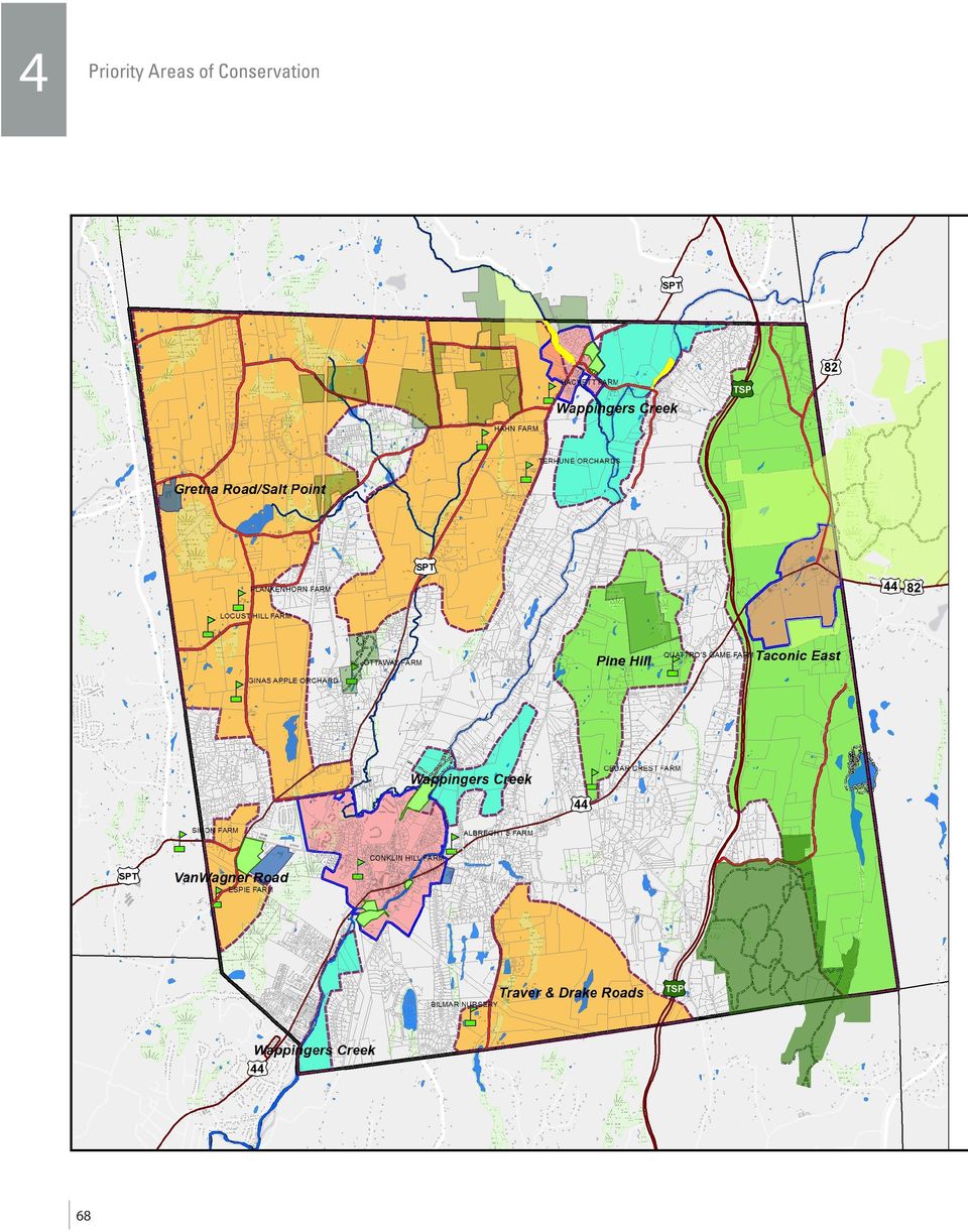
9 Exhibit 4.2 Significant Resource Areas (with Tax Parcels) 69

10 4 Priority Areas of Conservation County Environmental Management Council (DCEMC). This designation means that this area contributes significantly to the health, diversity, and enjoyment of the County s resource base. This same area supports a variety of wildlife and as such, has also been designated by NYS- DEC as New York State Significant Habitat. However, most privately owned parcels within this greenway area are not under any permanent development restrictions. It is this combination of existing conserved lands, high quality natural resources and large contiguous adjacent open spaces extending well to the east that makes this area particularly important for a coordinated conservation effort. This Plan recommends that the Town work to initiate partnerships and take steps to ensure that more lands within this greenway corridor are permanently protected. B. PROPERTY OWNERSHIP It is important to note that Significant Resource Areas defined in this Plan, were based on analysis of overlaying environmental data and development patterns and not targeting specific, individual private properties. However, with the significant areas now defined, overlaying these areas with the individual tax parcels allows one to see exactly which land parcels lie within each of the Significant Resource Areas. Exhibit 4-2, Significant Resource Areas (with Tax Parcels) will be important to reference when opportunities arise to engage individual land owners about land conservation options. When assessing conservation opportunities, consultation and reliance of the identified Significant Resource Areas is only a first step. The Town would also most likely need to conduct a secondfilter analysis of priorities that would include factors that enter into land conservation priority decision-making, such as: Criteria of available grant funds or other potential sources of funding; Criteria or requirements of any potential project partners (such as a nonprofit land conservancy organizations or other public agencies); Taxpayer support for a particular project; Public cost/benefits analysis; and Geographic distribution of projects and the distribution of projects within particular resource categories (i.e. farms, forests, aquifers, etc.) and governmental boundaries (i.e. school districts). 70

13. ENVIRONMENTAL PROTECTION/ RESOURCE MANAGEMENT
 13. ENVIRONMENTAL PROTECTION/ RESOURCE MANAGEMENT A. Existing Conditions Ramsey is fortunate to have an ample amount of natural resources and open space areas and a community attitude that is increasingly
Permanently preserving privately owned productive agricultural land ensures a stable land base for the future of the agricultural industry.
 F A R M L A N D P R E S E R V A T I O N Permanently preserving privately owned productive agricultural land ensures a stable land base for the future of the agricultural industry. Farmland preservation,
COMPREHENSIVE PLAN SECTION B, ELEMENT 4 WATER RESOURCES. April 20, 2010 EXHIBIT 1
 COMPREHENSIVE PLAN SECTION B, ELEMENT 4 WATER RESOURCES April 20, 2010 EXHIBIT 1 ELEMENT 4 WATER RESOURCES TABLE OF CONTENTS 4.1 INTRODUCTION 4.2 GOALS AND POLICIES 4.2.A General Goals and Policies 1 4.2.B
Public Survey for Phase I
 Rockfish Valley Area Plan: Public Survey for Phase I For Nelson County Residents & Property Owners Name: OPTIONAL: Location of residence or property: o Address: o Voting District: North Central West South
AN INITIATIVE TO IMPROVE
 L OW E R C A R M E L R I V E R A N D L AG O O N F L O O D P L A I N R E S TO R AT I O N A N D E N H A N C E M E N T P R O J E C T AN INITIATIVE TO IMPROVE FLOOD PROTECTION RESTORE AND PROTECT RIPARIAN
BASIN MANAGEMENT OBJECTIVES CHEROKEE SUBINVENTORY UNIT
 BASIN MANAGEMENT OBJECTIVES CHEROKEE SUBINVENTORY UNIT Butte County Water Advisory Committee Member John Scott Contact Information Phone Number: (530) 533-8394 Email Address: [email protected] Description
Conservation Tax Credit Regulations Chapter 391-1-6 A-1 RULES OF GEORGIA DEPARTMENT OF NATURAL RESOURCES CHAPTER 391-1-6
 Conservation Tax Credit Regulations Chapter 391-1-6 A-1 RULES OF GEORGIA DEPARTMENT OF NATURAL RESOURCES CHAPTER 391-1-6 GEORGIA CONSERVATION TAX CREDIT PROGRAM TABLE OF CONTENTS 391-1-6-.01 Purpose and
Corridor Goals and Objectives
 Corridor Goals and Objectives This chapter presents the goals and objectives, developed by the Corridor Study Committee, that serve as the purpose and intent of the Corridor Plan. This plan covers a twenty
The Nature Conservancy Offering Protected Lands for Sale in the Adirondacks Sustainable Forestry to Continue
 News release For immediate release August 21, 2008 Contact: Connie Prickett, (518) 576-2082 x162, [email protected] The Nature Conservancy Offering Protected Lands for Sale in the Adirondacks Sustainable
TABLE OF CONTENTS. INTRODUCTION...1 Purpose of a Comprehensive Plan...1 McKenzie County Comprehensive Plan...1 Definitions...2 Goal...2 Vision...
 MCKENZIE COUNTY COMPREHENSIVE PLAN TABLE OF CONTENTS INTRODUCTION...1 Purpose of a Comprehensive Plan...1 McKenzie County Comprehensive Plan...1 Definitions...2 Goal....2 Vision...3 ECONOMIC DEVELOPMENT...4
4.2 Buena Vista Creek Watershed
 Buena Vista Creek Watershed 4.2 Buena Vista Creek Watershed Watershed Overview The Buena Vista Creek Watershed is the fourth-largest system within the Carlsbad Hydrologic Unit. The watershed extends approximately
Using Land Use Planning Tools to Support Strategic Conservation
 Using Land Use Planning Tools to Support Strategic Conservation Resources A Citizen s Guide to Planning & Zoning in Virginia (2003) Provides background information on how basic land use planning tools
Natural Resource-Based Planning*
 Natural Resource-Based Planning* Planning, when done well, is among the most powerful tools available to communities. A solid plan, based on good natural resource information, guides rational land-use
Appendix A: Land Protection Plan
 Appendix A: Land Protection Plan In this appendix A.1 Introduction and Purpose A.2 Project Description A.3 Refuge Purposes A.4 Land Acquisition Policy for Urban Refuges A.5 Status of Resources to be Protected
Briefing Paper on Lower Galveston Bay and Bayou Watersheds Lower Bay I: Armand Bayou to Moses Lake and Adjacent Bay Waters
 Briefing Paper on Lower Galveston Bay and Bayou Watersheds Lower Bay I: Armand Bayou to Moses Lake and Adjacent Bay Waters Jim Lester, PhD. and Lisa Gonzalez Houston Advanced Research Center Galveston
SANTA BARBARA COUNTY COMPREHENSIVE PLAN LOMPOC AREA
 SANTA BARBARA COUNTY COMPREHENSIVE PLAN LOMPOC AREA A. LAND USE ELEMENT INTERPRETIVE GUIDELINES B. COMMUNITY BENEFITS C. COUNTY ACTION ITEMS Adopted by the Board of Supervisors November 9, 1999 A. Santa
Presentation to Knox County Commission Monday, February 23, 2015
 The Northwest County Sector Plan Update Presentation to Knox County Commission Monday, February 23, 2015 COMMUNITIES OF THE NORTHWEST COUNTY SECTOR Ball Camp Cedar Bluff Last NW Sector Update: 2003 Land
Case No.: A-9955-C COUNTY COUNCIL OF PRINCE GEORGE'S COUNTY, MARYLAND, SITTING AS THE DISTRICT COUNCIL ZONING ORDINANCE NO. 5-2005
 Case No.: A-9955-C Applicant: Florida on the Potomac, LLC COUNTY COUNCIL OF PRINCE GEORGE'S COUNTY, MARYLAND, SITTING AS THE DISTRICT COUNCIL ZONING ORDINANCE NO. 5-2005 AN ORDINANCE to amend the Zoning
LEAGUE NOTES ON APPROVED COMMUNITY WATER SUPPLY PLAN
 1 AUGUST 2011 LEAGUE NOTES ON APPROVED COMMUNITY WATER SUPPLY PLAN KEY ELEMENTS OF THE PLAN: 1. Replace the existing unsafe Ragged Mountain dam with a new dam and raise the reservoir pool level initially
FLOOD PROTECTION AND ECOSYSTEM SERVICES IN THE CHEHALIS RIVER BASIN. May 2010. Prepared by. for the. 2010 by Earth Economics
 FLOOD PROTECTION AND ECOSYSTEM SERVICES IN THE CHEHALIS RIVER BASIN May 2010 Prepared by for the Execubve Summary The Chehalis Basin experienced catastrophic flooding in 2007 and 2009. In response, the
Rural Residential Buildable Lands Inventory
 The Dalles Periodic Review, May 2013 Rural Residential Lands Inventory Contents Introduction and Summary... 1 Concerns related to the 2007 Analysis... 2 Rural Residential Capacity Summary... 2 Methodology...
NATURAL RESOURCES & NATURAL FEATURES
 A3 NATURAL RESOURCES & NATURAL FEATURES INTRODUCTION This chapter will discuss the topography, geology, soils, and other natural features found in Casco Township. The identification of the natural features
Ecosystem Services in the Greater Houston Region. A case study analysis and recommendations for policy initiatives
 Ecosystem Services in the Greater Houston Region A case study analysis and recommendations for policy initiatives Ecosystem Services Ecosystems provide services through their natural processes that we
SPECIAL USE PERMIT 22-01. JCSA Groundwater Treatment Facility Staff Report for the November 5, 2001, Planning Commission Public Hearing
 SPECIAL USE PERMIT 22-01. JCSA Groundwater Treatment Facility Staff Report for the November 5, 2001, Planning Commission Public Hearing This report is prepared by the James City County Planning Division
Using an All lands Framework for Conservation of Ecosystem Services
 Using an All lands Framework for Conservation of Ecosystem Services Robert Deal USDA Forest Service - PNW Research Station, Portland, OR Nikola Smith USDA Forest Service - Pacific Northwest Region, Portland,
3. The submittal shall include a proposed scope of work to confirm the provided project description;
 QIN Shoreline Master Program Project Summary The Shoreline Master Program (SMP) development process for the Quinault Indian Nation (QIN) includes the completion of inventory and analysis report with corresponding
APPENDIX B: TRAIL DEVELOPMENT AND MANAGEMENT STANDARDS
 APPENDIX B: TRAIL DEVELOPMENT AND MANAGEMENT STANDARDS This section provides guidance on a variety of trail issues for planners and developers of the Ice Age NST across the state. It also provides introductory
Rhode Island NRCS received approximately $2.4 million in ARRA funds to implement four floodplain easement projects.
 American Recovery and Reinvestment Act (ARRA) Emergency Watershed Protection Program Floodplain Easements Rhode Island Natural Resources Conservation Service Rhode Island NRCS received approximately $2.4
Clean Water Services. Ecosystems Services Case Study: Tualatin River, Washington
 Viewed broadly, the concept of ecosystem services describes the many resources and services provided by nature. Typically, traditional planning and development practices do not adequately represent the
EXHIBIT A LOCATION MAP AND LAND USE INFORMATION
 EXHIBIT A LOCATION MAP AND LAND USE INFORMATION In accordance with Arizona Corporation Commission Rules of Practice and Procedure R14-3-219, Applicant provides the following location maps and land use
Lower Crooked Creek Watershed Conservation Plan EXECUTIVE SUMMARY
 EXECUTIVE SUMMARY Project Background Located in southwestern Pennsylvania, Crooked Creek is a major tributary of the Allegheny River, entering near Ford City in Armstrong County. It is rich in natural
Markets for Ecosystem Services on Agricultural Lands: Experience and Outlook in the United States
 Markets for Ecosystem Services on Agricultural Lands: Experience and Outlook in the United States Frank Casey Conservation Economics and Finance Program Defenders of Wildlife Presented at the Biodiversity
PROPERTY TAX RELIEF PROGRAMS
 PROPERTY TAX RELIEF PROGRAMS S.L. 2009-574 Studies Bill Revenue Laws Study Committee authorized to study issues relating to the effects on local units of government of enacted property tax relief programs
Revising the Nantahala and Pisgah Land Management Plan Preliminary Need to Change the Existing Land Management Plan
 Revising the Nantahala and Pisgah Land Management Plan Preliminary Need to Change the Existing Land Management Plan Throughout the Plan 1. There is a fundamental need for the revised plan to address how
Village of Spring Valley Comprehensive Plan 2009-2029
 Chapter 8: Intergovernmental Cooperation Introduction Intergovernmental communication, coordination, and cooperation can make a significant difference in the implementation and administration of a comprehensive
Series 2016A-2 (Green Bonds) Final Proceeds Allocation April 2016
 Final Proceeds Allocation April 2016") Series 2016A-2 (Green Bonds) Final Proceeds Allocation April 2016 James L. McIntire Washington State Treasurer Summary The State of Washington offered green bonds to investors in September 2015, with approximately
Series 2016A-2 (Green Bonds) Final Proceeds Allocation April 2016 James L. McIntire Washington State Treasurer Summary The State of Washington offered green bonds to investors in September 2015, with approximately
Restoring Anadromous Fish Habitat in Big Canyon Creek Watershed. Summary Report 2002
 Restoring Anadromous Fish Habitat in Big Canyon Creek Watershed Summary Report 2002 DOE/BP-00005268-5 November 2002 This Document should be cited as follows: "Restoring Anadromous Fish Habitat in Big Canyon
Produced by: Conservation Trust for North Carolina on behalf of. with funding from WalMart
 Produced by: Conservation Trust for North Carolina on behalf of with funding from WalMart 4th Edition 2010 by the Conservation Trust for North Carolina and N.C. Coastal Land Trust 4th Edition Credits:
Photo by Jeff Thibodeau, Helios Land Design
 SECTION 11 REFERENCES Photo by Jeff Thibodeau, Helios Land Design PUBLIC REVIEW DRAFT Cape Cod Commission, Affordable Housing Funds, Memo from Paul Ruchinskas to County Commissioners, January 4, 2006.
Town of Yorktown Comprehensive Plan 8. INFRASTRUCTURE
 Town of Yorktown Comprehensive Plan 8. INFRASTRUCTURE 8. Infrastructure 8.1 VISION STATEMENT Infrastructure is a basic building block of the community essential for the health, safety, and welfare of residents.
Adopted 9/23/98 CHATTAHOOCHEE CORRIDOR PLAN. The goals of the Chattahoochee Corridor Plan (hereinafter also referred to as the Plan ) are:
 are:") CHATTAHOOCHEE CORRIDOR PLAN Adopted 9/23/98 PART 1: GOALS. POLICY. COVERAGE. A. Goals The goals of the Chattahoochee Corridor Plan (hereinafter also referred to as the Plan ) are: 1. Preservation and protection
CHATTAHOOCHEE CORRIDOR PLAN Adopted 9/23/98 PART 1: GOALS. POLICY. COVERAGE. A. Goals The goals of the Chattahoochee Corridor Plan (hereinafter also referred to as the Plan ) are: 1. Preservation and protection
Rocky EEP Preliminary Findings Report Summary February 2005
 This is a DRAFT summary of the NC Ecosystem Enhancement Upper Rocky River Local Watershed Plan Preliminary Findings Report. The original, 157 page document can be found here: www.ncsu.edu/weco/rocky. The
As stewards of the land, farmers must protect the quality of our environment and conserve the natural resources that sustain it by implementing
 N A T U R A L R E S O U R C E C O N S E R V A T I O N As stewards of the land, farmers must protect the quality of our environment and conserve the natural resources that sustain it by implementing conservation
7.0 INTRODUCTION 7.1 BACKGROUND
 Section 7: Economic Development 7.0 INTRODUCTION A community s character is a function of its residential neighborhoods, its open spaces, and its commercial districts. Commercial uses also play another
Halton Region Planning & Public Works Committee Meeting July 8, 2015
 Acton Quarry Extension Halton Region Planning & Public Works Committee Meeting July 8, 2015 1 Proposed Extraction Area 50% Reduction The extraction area was reduced by 50% to address comments from the
Site Alternative Deliverability Report. SALT 034 Ty Nant, Groesffordd Resubmission: Deliverable. Local Development Plan
 Local Development Plan Site Alternative Deliverability Report Brecon Beacons National Park Authority SALT 034 Ty Nant, Groesffordd Resubmission: Deliverable SALT 034 Ty Nant Groesffordd (Llanfrynach) Existing
III. Vision and Goals
 III. Vision and Goals In 1998, OPRHP acquired over 3,200 acres of land that more than tripled the size of Moreau Lake State Park. Now, Moreau Lake State Park is the largest park in the Saratoga- Capital
Chehalis River Basin Flood Damage Reduction 2013-2015 Capital Budget Approved by Legislature in June 2013
 Chehalis River Basin Flood Damage Reduction 2013-2015 Capital Budget Approved by Legislature in June 2013 1. Design alternatives for large capital flood projects (basinlevel water retention and Interstate
Healthy Forests Resilient Water Supply Vibrant Economy. Ecological Restoration Institute
 Healthy Forests Resilient Water Supply Vibrant Economy Ecological Restoration Institute How Water Gets to Your Home MOST OF THE VALLEY S WATER SUPPLY comes from winter precipitation and runoff from Arizona
How To Plan A Buffer Zone
 Backyard Buffers Protecting Habitat and Water Quality What is a buffer? A buffer (also called a riparian buffer area or zone) is the strip of natural vegetation along the bank of a stream, lake or other
NATURAL REGIONS OF KENTUCKY
 NATURAL WONDERS As you travel around Kentucky taking pictures, you are excited by what you see. Kentucky offers diverse and amazing sights. The Six Regions In the West, you see the Mississippi River, the
MAPPING MINNEAPOLIS URBAN TREE CANOPY. Why is Tree Canopy Important? Project Background. Mapping Minneapolis Urban Tree Canopy.
 MAPPING MINNEAPOLIS URBAN TREE CANOPY Why is Tree Canopy Important? Trees are an important component of urban environments. In addition to their aesthetic value, trees have significant economic and environmental
Fayette County Appraisal District
 Fayette County Appraisal District Agricultural Guidelines July 7, 2010 A SUPPLEMENT TO THE STATE OF TEXAS PROPERTY TAX MANUAL FOR THE APPRAISAL OF AGRICULTUAL LAND AND WILDLIFE MANAGEMENT ACTIVITIES AND
Chapter 9. Selected Watershed Initiatives in the Great Basin Region
 Chapter 9 Selected Watershed Initiatives in the Great Basin Region The Great Basin contains vast areas of sparsely populated desert lands. Lacking an ocean drainage, the Great Basin is a hydrologic sink
Niki L. Pace, Research Counsel Mississippi Alabama Sea Grant Legal Program September 15, 2009
 Niki L. Pace, Research Counsel Mississippi Alabama Sea Grant Legal Program September 15, 2009 What is a land trust? A land trust is a private, nonprofit organization whose mission is the acquisition and
1.7.0 Floodplain Modification Criteria
 1.7.0 Floodplain Modification Criteria 1.7.1 Introduction These guidelines set out standards for evaluating and processing proposed modifications of the 100- year floodplain with the following objectives:
Sewage Disposal plan
 Community Utilities Plan Sewage Disposal plan Existing Facilities There are three public sewage treatment plants and four central sewage systems operating in the Nazareth Area. A public sewage system is
Appendix J Online Questionnaire
 Appendix J Online Questionnaire In accordance with the Paperwork Reduction Act, this questionnaire was approved by the Office of Management and Budget (OMB). The OMB control number and expiration date
Baltimore County Land Preservation: A Status Report and Call to Action
 Baltimore County Land Preservation: A Status Report and Call to Action Prepared by: Baltimore County Land Trust Alliance October 2014 The Baltimore County Land Trust Alliance (BCLTA) is a voluntary coalition
PROPOSAL FOR HOUSTON COUNTY BAN ON SILICA SAND MINING / PROCESSING ACTIVITY. Introduction and Assumptions
 PROPOSAL FOR HOUSTON COUNTY BAN ON SILICA SAND MINING / PROCESSING ACTIVITY Introduction and Assumptions 1. The existing section 27 Mineral Extraction of the Zoning Ordinance would remain and continue
9.0 Alta Vista/Faircrest Heights/Riverview Park (Key Principles)
") 9.0 Alta Vista/Faircrest Heights/Riverview Park (Key Principles) Official Plan Consolidation for the City of Ottawa 1 9.1 Location This Chapter applies to Alta Vista/Faircrest/Riverview Park, which corresponds
9.0 Alta Vista/Faircrest Heights/Riverview Park (Key Principles) Official Plan Consolidation for the City of Ottawa 1 9.1 Location This Chapter applies to Alta Vista/Faircrest/Riverview Park, which corresponds
Summary of the Second College Grant Master Plan
 1 Summary of the Second College Grant Master Plan Dartmouth College owns and manages 27,000 acres of woodland in the Northern Forest region of New Hampshire, near Erroll, New Hampshire and the Maine state
Arizona s Large Fires Suppression vs. Restoration. WESTCAS Fall 2011 Meeting Bruce Hallin Manager, Water Rights and Contracts October 27, 2011
 Arizona s Large Fires Suppression vs. Restoration WESTCAS Fall 2011 Meeting Bruce Hallin Manager, Water Rights and Contracts October 27, 2011 THE PROBLEM Unhealthy Forests Since 2000, at least 1,501,654
Use Of Natural Resource Damages Settlement Funds For Watershed Protection At The Fernald Preserve, Harrison, Ohio 15309
 Use Of Natural Resource Damages Settlement Funds For Watershed Protection At The Fernald Preserve, Harrison, Ohio 15309 Gwendolyn Hooten *, Tom Schneider **, Jennifer Finfera ***, William Hertel ****,
QUESTIONS AND ANSWERS WATERS OF THE U.S. PROPOSAL
 QUESTIONS AND ANSWERS WATERS OF THE U.S. PROPOSAL Key Background Congress enacted the modern Clean Water Act in 1972 to address pollution entering the nation s waters to complement statutes such as the
19310 STONE OAK PKWY, STE. 201 SAN ANTONIO, TEXAS 78258 T: 210.402.6363 F: 210.402.6767 www.drakecommercial.com
 Multi-Family Land Sonoma Verde Kyle Seale Parkway San Antonio, Texas DRAKE COMMERCIAL GROUP DEBORAH BAUER TRAVIS BAUER 19310 STONE OAK PKWY, STE. 201 SAN ANTONIO, TEXAS 78258 T: 210.402.6363 F: 210.402.6767
Why should communities invest in resiliency? What are the steps communities can take to become more resilient?
 Community Preparedness for Flood Resiliency Nina Peek, AICP New York Planning Federation Board of Directors Senior Technical Director AKRF, Inc. Focus of Today s Presentation Why should communities invest
2015 -- H 6042 S T A T E O F R H O D E I S L A N D
 LC00 01 -- H 0 S T A T E O F R H O D E I S L A N D IN GENERAL ASSEMBLY JANUARY SESSION, A.D. 01 A N A C T RELATING TO TOWNS AND CITIES -- RHODE ISLAND COMPREHENSIVE PLANNING AND LAND USE ACT Introduced
Using Aerial Photography to Measure Habitat Changes. Method
 Then and Now Using Aerial Photography to Measure Habitat Changes Method Subject Areas: environmental education, science, social studies Conceptual Framework Topic References: HIIIB, HIIIB1, HIIIB2, HIIIB3,
Chapter 7 ZONING PLAN
 Chapter 7 ZONING PLAN Introduction This Chapter opens with a general description of a zoning plan. It is followed by a brief explanation of the relationship between this Growth Management Plan and the
Appendix A: Affordable Housing Site Inventory
 Appendix A: Affordable Housing Site Inventory Following is a brief summary of the various sites considered for the Affordable Housing Project. Each site is provided with a photo when available and a concise
CHAPTER 1 INTRODUCTION AND SETTING FOR THE PLAN
 CHAPTER 1 INTRODUCTION AND SETTING FOR THE PLAN 1 Why a Comprehensive Plan? The purpose of the Comprehensive Plan is to work proactively to assure that the future of the Germany/Littlestown/Union Region
Remaining Wetland Acreage 1,500,000 915,960 584,040-39%
 NEW JERSEY Original Wetland Acreage Remaining Wetland Acreage Acreage Lost % Lost 1,500,000 915,960 584,040-39% New Jersey Wetlands: Nearly 99 percent of New Jersey s wetlands are palustrine or estuarine.
Water Quality and Water Usage Surveys
 Appendix 1 Water Quality and Water Usage Surveys This appendix contains copies of the Water Quality Survey and the Lake Usage Survey that we used to complete the watershedbased community assessments. We
Market-Based Planning Tools: An Overview of TDRs and PDRs
 Market-Based Planning Tools: An Overview of TDRs and PDRs Kevin Cheshire, Research Fellow, Coastal Resources, Law, Planning and Policy Center February 12, 2007 1 Introduction Planners and local governments
Acton Quarry Extension. Halton Region June 11, 2014
 Acton Quarry Extension Halton Region June 11, 2014 1 Background Background Proposed Extraction Area Compliance with Ministry Guidelines Halton Region Official Plan Greenlands System Conveyance of Land
How Your Property Tax Is Determined
 Property Tax Relief for Forest Landowners by Mel Baughman Extension Forester and Program Leader, University of Minnesota, Department of Forest Resources and University of Minnesota Extension, St. Paul,
Green Infrastructure Case Study Template
 Green Infrastructure Case Study Template The aim of the exercise is to provide information on how the elements of the Green Infrastructure Strategy are implemented at national level and to provide case