Project Overview Mapping Technology Assessment for Connected Vehicle Highway Network Applications
|
|
|
- Adelia Norman
- 10 years ago
- Views:
Transcription
1 Project Overview Mapping Technology Assessment for Connected Vehicle Highway Network Applications CGSIC Seattle Washington August2012

2 Table Of Contents Connected Vehicle Program Goals Mapping Technology Assessment Approach Field Test

3 Connected Vehicle Program Goals and Objectives FHWA s Connected Vehicle Program was established to facilitate the implementation of applications related to vehicles and/or infrastructure for helping to enhance safety, mobility, and the environment. Communications These applications will utilize mapping, positioning, and communication technology for their operations to provide information on the location of vehicles in relation to the roadway, other vehicles, and pedestrians. Positioning Connected Vehicle Highway Network Applications Mapping Connected Vehicle is a large, multi-faceted program managed by the ITS Joint Program Office of the Research and Innovative Technology Administration (RITA) Signal Phase and Timing

4 Communications Technologies Wide Area Duplex Link Wide Area Broadcast Link Traffic Signal Controller DSRC 3

5 Positioning Technologies 4

6 Relative Position of Targets Referenced to Absolute Position Provided by GPS Relative Position Relative Position Sensor Azimuth Error Range Error Note: Also may have Elevation Error ; however generally not used. Absolute Position: Area in which the Vehicle Position Lies, within the Specified Confidence Level (Typically 95%) 5

7 Signal Phase and Timing System Setup Roadside equipment (DSRC) traffic signal controller DSRC-enabled vehicle 6

8 Mapping Technologies As one of the main supporting technologies of the Connected Vehicle Program, Mapping Technologies provide critical support across safety, mobility, and environment applications through the provision and update of roadway data The mapping of roadways involves developing an accurate geometric representation of the roadway and attribution of those geometries with application relevant data Roadways are usually represented in GIS databases as linear features. Lane configuration and connectivity may also be represented in the form of additional geometries in the database or through attribution The development of maps supporting Connected Vehicle applications requires the initial creation of the maps as well as ongoing, timely update of these maps 7

9 Mapping Technology Assessment Project The Mapping Technology Assessment for Connected Vehicle Highway Network Applications project aimed to analyze and determine the best current and anticipated geospatial technologies and mapping approaches to support intelligent transportation systems (ITS) This assessment is fundamental to providing solutions that allow connected vehicle network applications to bring about transformational improvements in the safety, mobility, and environmental performance of our nation s transportation systems Mapping Technologies are a key enabler for the Program and its applications Vehicles need to know where they are in relation to other vehicles (relative position) Vehicles need to know where they are in relation to the roadway (absolute position) The focus of the project is across 3 major areas: Assess what mapping technologies meet the requirements of Connected Vehicle applications Test relevant technologies in lab and in the Connected Vehicle Highway Testbed (CVHT) Develop a data management framework for compilation, storage, and update of collected data The goal of the connected vehicle vision is high, but the potential benefits are significant as implementation of connected vehicle network applications can have far reaching impacts on transportation 8
 Vehicles need to know where they are in relation to the roadway (absolute position)")
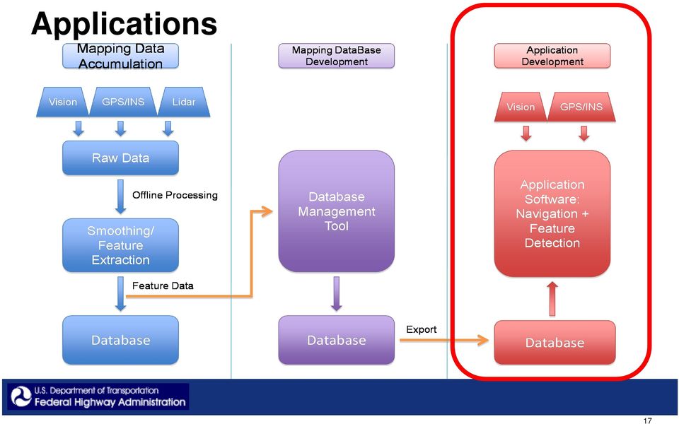
10 Overview of Field Test Data Flow Process Mapping Data Accumulation Mapping DataBase Development Application Demonstration Development Vision GPS/INS Lidar Vision GPS/INS Raw Data Smoothing/ Feature Extraction Offline Processing Database Management Tool Application Software: Navigation + Feature Detection Feature Data Database Database Export Database 9

11 GPS/IMU LIDAR sensor platform Panoramic camera 10

12 Equipment Configuration for Field Test Vehicle Mounting of Equipment 11

13 Mapping Sensors and Data Rates LIDAR Camera set IMU GNSS Receiver High capacity HD Roof Platform Power supply CPU 12

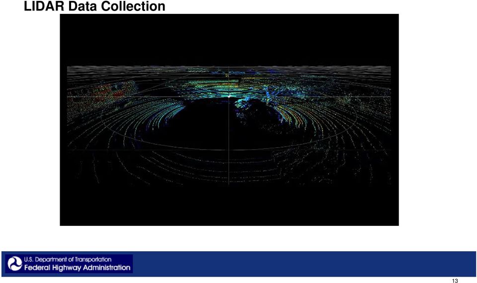
14 LIDAR Data Collection 13
15 Road Signs Locations RS RS1 17 RS2 RS3 4 RS4 12 RS6 16 RS

16 Map Database 15

17 Bing Map, TFHRC Aerial Image, LIDAR-based intensity image overlay combined in ArcMap 16

18 Applications 17
19 Inexpensive GPS/IMU Sensor platform for positioning No LIDAR sensor platform Inexpensive rectilinear camera No panoramic camera 18

20 Application Graphical User Interface 19

21 Lane Departure Warning 20
22 Curve Overspeed Warning 21
23 Field Study Summary Automated sensor-based mapping is necessary for nationwide lane-level map production This project task developed software and demonstrated that automated sensor-based mapping is feasible with centimeter-level accuracy Two lane-level applications built on the foundation of lane-level maps were demonstrated using decimeter-level positioning techniques Lane departure warning Curve overspeed warning Future lane-level application Signal Phase and Timing, at lane-level 22
24 Potential Areas of Future Research/Development Thorough process evaluation in less-structured, more-dynamic environments Transition from semi-automated to fully automated mapping process Maintenance of the precision map Crowd sourcing Targeted updates Large scale computer or cloud implementation for mapping larger environments 23
25 Questions? Contact info: 24
IP-S3 HD1. Compact, High-Density 3D Mobile Mapping System
 IP-S3 HD1 Compact, High-Density 3D Mobile Mapping System Integrated, turnkey solution Ultra-compact design Multiple lasers minimize scanning shades Unparalleled ease-of-use No user calibration required
IP-S2 HD. High Definition 3D Mobile Mapping System
 IP-S2 HD High Definition 3D Mobile Mapping System Integrated, turnkey solution High Density, Long Range LiDAR sensor for ultimate in visual detail High Accuracy IMU and DMI Odometry for positional accuracy
IP-S2 Compact+ 3D Mobile Mapping System
 IP-S2 Compact+ 3D Mobile Mapping System 3D scanning of road and roadside features Delivers high density point clouds and 360 spherical imagery High accuracy IMU options without export control Simple Map,
Intergraph Roadway Information Management Solution. Title Title. Title Title. A White Paper
 Intergraph Roadway Information Management Solution A White Paper Security, Government & Infrastructure, a division of Intergraph Title Title Title Title Table of Contents 1. Introduction... 1 2. Intergraph
JEREMY SALINGER Innovation Program Manager Electrical & Control Systems Research Lab GM Global Research & Development
 JEREMY SALINGER Innovation Program Manager Electrical & Control Systems Research Lab GM Global Research & Development ROADMAP TO AUTOMATED DRIVING Autonomous Driving (Chauffeured Driving) Increasing Capability
automatic road sign detection from survey video
 automatic road sign detection from survey video by paul stapleton gps4.us.com 10 ACSM BULLETIN february 2012 tech feature In the fields of road asset management and mapping for navigation, clients increasingly
Automatic Labeling of Lane Markings for Autonomous Vehicles
 Automatic Labeling of Lane Markings for Autonomous Vehicles Jeffrey Kiske Stanford University 450 Serra Mall, Stanford, CA 94305 [email protected] 1. Introduction As autonomous vehicles become more popular,
EB Automotive Driver Assistance EB Assist Solutions. Damian Barnett Director Automotive Software June 5, 2015
 EB Automotive Driver Assistance EB Assist Solutions Damian Barnett Director Automotive Software June 5, 2015 Advanced driver assistance systems Market growth The Growth of ADAS is predicted to be about
Asset Data: A New Beginning, A New AURIZON. OmniSurveyor3D - The one source of truth
 Asset Data: A New Beginning, A New AURIZON OmniSurveyor3D - The one source of truth Gerard Buckett Program Manager, Asset Management Improvement, Aurizon Network 30 years experience in rail engineering
CONVERGENCE OF MMS AND PAVEMENT INSPECTION SENSORS FOR COMPLETE ROAD ASSESSMENT
 6th International Symposium on Mobile Mapping Technology, Presidente Prudente, São Paulo, Brazil, July 21-24, 2009 CONVERGENCE OF MMS AND PAVEMENT INSPECTION SENSORS FOR COMPLETE ROAD ASSESSMENT C. Larouche
Land Mobile Mapping & Survey
 Land Mobile Mapping & Survey Trimble Geospatial Solutions Trimble s geospatial solution portfolio has been designed to put information to work. Mobile sensors on the land, in the air or indoors capture
Public Sector Solutions
 Public Sector Solutions The New Jersey DOT Command Center uses INRIX real-time data and analytics to monitor congestion and deploy resources proactively to manage traffic flow and inform travelers. INRIX
Integration of Inertial Measurements with GNSS -NovAtel SPAN Architecture-
 Integration of Inertial Measurements with GNSS -NovAtel SPAN Architecture- Sandy Kennedy, Jason Hamilton NovAtel Inc., Canada Edgar v. Hinueber imar GmbH, Germany Symposium Gyro Technology, Stuttgart 9/25
Engineers from Geodetics select KVH for versatile high-performance inertial sensors. White Paper. kvh.com
 White Paper Overcoming GNSS Vulnerability by Applying Inertial Data Integration in Multi-Sensor Systems for High Accuracy Navigation, Pointing, and Timing Solutions Engineers from Geodetics select KVH
Integrated Data System Structure for Active Traffic Management - Planning and Operation
 Integrated Data System Structure for Active Traffic Management - Planning and Operation NATMEC 2010 Dr. Xiao-Yun Lu, Research Engineer California PATH, U. C. Berkeley J. Palen, Caltrans DRI 1 Outlines
How To Fuse A Point Cloud With A Laser And Image Data From A Pointcloud
 REAL TIME 3D FUSION OF IMAGERY AND MOBILE LIDAR Paul Mrstik, Vice President Technology Kresimir Kusevic, R&D Engineer Terrapoint Inc. 140-1 Antares Dr. Ottawa, Ontario K2E 8C4 Canada [email protected]
September 8th 8:30 AM 10:00 AM PL1: Reinventing Policy to Support the New ITS
 September 8th 8:30 AM 10:00 AM PL1: Reinventing Policy to Support the New ITS September 8th 10:30 AM 12:00 PM AM01: Sustainable Transportation Performance Measures: Best Practices September 8th 10:30 AM
Cost-Effective Collection of a Network-Level Asset Inventory. Michael Nieminen, Roadware
 Cost-Effective Collection of a Network-Level Asset Inventory Michael Nieminen, Roadware Introduction This presentation is about using a mobile vehicle to collect roadway asset (feature) data. Asset/Feature
FLEET MANAGEMENT SYSTEM FOR TRAFFIC CONTROL DEVICES. www.atstrafficgroup.com
 FLEET MANAGEMENT SYSTEM FOR TRAFFIC CONTROL DEVICES OVERVIEW JamLogic is an semi-automatic or (optional) fully automated web-based application that wirelessly allows you to MONITOR, MAINTAIN and MANAGE
Asset Management for MAP-21. Gary Lasham, P.E. Jonathan Pollack
 Asset Management for MAP-21 Gary Lasham, P.E. Jonathan Pollack Replaced Intermodal Surface Transportation Efficiency Act (ISTEA) MAP-21 is transforming the policy and programmatic framework for investments
GPS/INS Integration with the imar-fsas IMU
 Sandy KENNEDY, Canada Jason HAMILTON, Canada Hugh MARTELL, Canada Key words: GPS, INS, integrated navigation, inertial navigation SUMMARY This paper discusses NovAtel's approach to GPS/INS system architecture
analysis needs be met at the push of a button?
 can all of your traffic analysis needs be met at the push of a button? A SOLUTION FOR ALL TRAFFIC ANALYSIS NEEDS How do you conduct traffic studies, evaluate new development impacts, and time your signals
GIS DATA CAPTURE APPLICATIONS MANDLI COMMUNICATIONS http://www.mandli.com
 GIS DATA CAPTURE APPLICATIONS MANDLI COMMUNICATIONS http://www.mandli.com Mandli Communications is a leader in specialized digital imaging equipment. Since 1983, the company has produced a range of imaging,
A GUIDE TO COLLECTING, PROCESSING, AND MANAGING ROADWAY ASSET INVENTORY DATA FINAL REPORT
 NCHRP Project 20 07/Task 357 A GUIDE TO COLLECTING, PROCESSING, AND MANAGING ROADWAY ASSET INVENTORY DATA FINAL REPORT Requested by: American Association of State Highway and Transportation Officials (AASHTO)
Mobile 360 Degree Imagery: Cost Effective Rail Network Asset Management October 22nd, 2015. Eric McCuaig, Trimble Navigation
 Mobile 360 Degree Imagery: Cost Effective Rail Network Asset Management October 22nd, 2015 Eric McCuaig, Trimble Navigation The debate: Point Clouds vs. Imagery Both are useful pick the right tool for
TomTom HAD story How TomTom enables Highly Automated Driving
 TomTom HAD story How TomTom enables Highly Automated Driving Automotive World Webinar 12 March 2015 Jan-Maarten de Vries VP Product Marketing TomTom Automotive Automated driving is real and it is big Image:
3D Vision An enabling Technology for Advanced Driver Assistance and Autonomous Offroad Driving
 3D Vision An enabling Technology for Advanced Driver Assistance and Autonomous Offroad Driving AIT Austrian Institute of Technology Safety & Security Department Christian Zinner Safe and Autonomous Systems
The demonstration will be performed in the INTA high speed ring to emulate highway geometry and driving conditions.
 Company / Contact: Description of your project Description of your vehicle/ mock up High speed CACC with lateral control AUTOPÍA Program Centro de Automática y Robótica (UPM-CSC) The goal of this demonstration
siemens.com/tolling Back-office system Sitraffic Sensus Server Supplies all front-end data. Suitable for any GNSS tolling back-office.
 siemens.com/tolling Back-office system Server Supplies all front-end data. Suitable for any GNSS tolling back-office. Server: The universal back-office for efficient and effective toll collection Server
Overview of BeiDou/GPS Applied in Road Transportation Li Jing China Transport Telecommunication & Information Center(CTTIC) Ministry of Transport of
 Ministry of Transport of") Overview of BeiDou/GPS Applied in Road Transportation Li Jing China Transport Telecommunication & Information Center(CTTIC) Ministry of Transport of the People s Republic of China ICG 7 11/5/2012 1 Current
Overview of BeiDou/GPS Applied in Road Transportation Li Jing China Transport Telecommunication & Information Center(CTTIC) Ministry of Transport of the People s Republic of China ICG 7 11/5/2012 1 Current
Presented by: Dr. Senanu Ashiabor, Intermodal Logistics Consulting Inc. at 2015 North Carolina MPO Conference April 30, 2015
 Presented by: Dr. Senanu Ashiabor, Intermodal Logistics Consulting Inc. at 2015 North Carolina MPO Conference April 30, 2015 What is Big Data? Big data is a broad term for large datasets that are so large
Technical Trends of Driver Assistance/ Automated Driving
 Technical Trends of Driver Assistance/ Automated Driving Presented by Tjark Kreuzinger Senior Manager, Safety research and Technical Affairs Toyota Motor Europe NV/SV TOYOTA MOTOR CORPORATION Topics 1.
3D GIS: It s a Brave New World
 3D GIS: It s a Brave New World Reida ELWANNAS, United Arab Emirates Key words: 3D Models, CityGML, GIS SUMMARY For the past several decades we have been enjoying the power of GIS. The introduction of 2.5D
Geospatial Cloud Computing - Perspectives for
 Geospatial Cloud Computing - Perspectives for Startups and Open Source Projects The Cases of OpenWebGlobe and 3D Vision Mobile Mapping for Urban Infrastructure Management Prof. Dr. Stephan Nebiker FHNW
BlipTrack. Case Studies. ANPR vs. Bluetooth. This case describes how data from ANPR cameras match corresponding Bluetooth sensor data.
 ANPR vs. Bluetooth This case describes how data from ANPR cameras match corresponding Bluetooth sensor data. The map shows an arterial road in the city of Aalborg with a total of 4 lanes, 2 in each direction.
Using Cloud-Computing to Promote Asset Management Best Practices A Ministry of Transportation Ontario Case Study
 Using Cloud-Computing to Promote Asset Management Best Practices A Ministry of Transportation Ontario Case Study Benjamin Ong Fugro Roadware 2505 Meadowvale Blvd. Mississauga, ON L5N 5S2 Ph: (905) 567-2870
ABSTRACT INTRODUCTION OVERVIEW OF POSTGRESQL AND POSTGIS SESUG 2012. Paper RI-14
 SESUG 2012 Paper RI-14 Creating a Heatmap Visualization of 150 Million GPS Points on Roadway Maps via SAS Shih-Ching Wu, Virginia Tech Transportation Institute, Blacksburg, Virginia Shane McLaughlin, Virginia
An Esri White Paper July 2010 Highway Data Management in ArcGIS
 An Esri White Paper July 2010 Highway Data Management in ArcGIS Esri, 380 New York St., Redlands, CA 92373-8100 USA TEL 909-793-2853 FAX 909-793-5953 E-MAIL [email protected] WEB www.esri.com Copyright 2010
Connected Vehicles: New Directions and Opportunities. AASHTO Connected Vehicle Task Force December 3, 2014 Irvine, CA. Leidos. All rights reserved.
 Connected Vehicles: New Directions and Opportunities AASHTO Connected Vehicle Task Force December 3, 2014 Irvine, CA N A T I O N A L S E C U R I T Y E N G I N E E R I N G H E A L T H S O L U T I O N S
INTEGRATING BIM AND GIS FOR ASSET MANAGEMENT
 INTEGRATING BIM AND GIS FOR ASSET MANAGEMENT Andy Chan MHKIBIM Project Manager Spatial Technology Limited Agenda Introduction of Asset Management Why GIS is not sufficient for Asset Management Data model
Integrating GIS-Based Videolog and Asset Data With Commonly Used Systems Provides Major Benefits With Minimal Effort
 Integrating GIS-Based Videolog and Asset Data With Commonly Used Systems Provides Major Benefits With Minimal Effort Presented By: Debbie Burns, GIS Manager Michael Nieminen, Project Manager Introduction
Intelligent Transport Systems (ITS): Needs for accurate and updated map data from public authorities
: Needs for accurate and updated map data from public authorities") Intelligent Transport Systems (ITS): Needs for accurate and updated map data from public authorities Maxime Flament, ERTICO ITS Europe [email protected] 1 What is ITS? 2 What is ITS? Intelligent
Intelligent Transport Systems (ITS): Needs for accurate and updated map data from public authorities Maxime Flament, ERTICO ITS Europe [email protected] 1 What is ITS? 2 What is ITS? Intelligent
ESRI and Xplore Technologies 2008 Mobile Government Demonstration Project Grant Program Final Report
 ESRI and Xplore Technologies 2008 Mobile Government Demonstration Project Grant Program Final Report Introduction and Project Purpose The ESRI and Xplore Technologies Mobile Government Demonstration Project
MobileMap and Spatial Content Management: Integrating Field Data Collection, Document Management and Enterprise GIS for Natural Resources
 MobileMap and Spatial Content Management: Integrating Field Data Collection, Document Management and Enterprise GIS for Natural Resources BRIAN GRASS MASON, BRUCE & GIRARD The Mobile Revolution Proliferation
Traffic Management for a Smarter City:Istanbul Istanbul Metropolitan Municipality
 Traffic Management for a Smarter City:Istanbul Istanbul Metropolitan Municipality Traffic Management for a Smarter City: Istanbul There is no doubt for Traffic Management to be an issue in a crowded city
Testimony of Ann Wilson House Energy & Commerce Committee Subcommittee on Commerce, Manufacturing and Trade, October 21, 2015
 House Energy & Commerce Committee Subcommittee on Commerce, Manufacturing and Trade, October 21, 2015 Introduction Chairman Burgess, Ranking Member Schakowsky, members of the subcommittee: Thank you for
How To Manage Big Data For The Ohio Department Of Transportation
 Big Data & Asset Management Ohio Planning Conference 2014 John R. Kasich, Governor Jerry Wray, Director Ohio Department of Transportation Big Data: Asset Management Andrew Williams, Administrator Office
CELL PHONE TRACKING. Index. Purpose. Description. Relevance for Large Scale Events. Options. Technologies. Impacts. Integration potential
 CELL PHONE TRACKING Index Purpose Description Relevance for Large Scale Events Options Technologies Impacts Integration potential Implementation Best Cases and Examples 1 of 10 Purpose Cell phone tracking
USDOT Connected Vehicle Overview
 USDOT Connected Vehicle Overview RWM Stakeholder Meeting August 8, 2012 Dale Thompson, Intelligent Transportation Systems Joint Program Office, RITA, U.S. DOT 1 Overview NHTSA Decision Safety Pilot Policy-Architecture
Product Characteristics Page 2. Management & Administration Page 2. Real-Time Detections & Alerts Page 4. Video Search Page 6
 Data Sheet savvi Version 5.3 savvi TM is a unified video analytics software solution that offers a wide variety of analytics functionalities through a single, easy to use platform that integrates with
EXPERIENCE WITH GEOGRAPHIC INFORMATION SYSTEMS (GIS) / MAPPING
 / MAPPING") EXPERIENCE WITH GEOGRAPHIC INFORMATION SYSTEMS (GIS) / MAPPING TEC has performed many GPS/GIS inventory projects and studies for the Ohio Department of Transportation (ODOT), Counties, and municipalities.
EXPERIENCE WITH GEOGRAPHIC INFORMATION SYSTEMS (GIS) / MAPPING TEC has performed many GPS/GIS inventory projects and studies for the Ohio Department of Transportation (ODOT), Counties, and municipalities.
GATEWAY CITIES TECHNOLOGY PROGRAM FOR GOODS MOVEMENT OVERVIEW OF EMERGING CONNECTED COMMERCIAL VEHICLES PROGRAM
 GATEWAY CITIES TECHNOLOGY PROGRAM FOR GOODS MOVEMENT OVERVIEW OF EMERGING CONNECTED COMMERCIAL VEHICLES PROGRAM Presented May 8, 2014 GATEWAY CITIES LOGISTICS CORRIDOR Anchored by Ports of Long Beach and
INTELLIGENT TRANSPORTATION SYSTEMS. Vehicle-to-Vehicle Technologies Expected to Offer Safety Benefits, but a Variety of Deployment Challenges Exist
 United States Government Accountability Office Report to Congressional Requesters November 2013 INTELLIGENT TRANSPORTATION SYSTEMS Vehicle-to-Vehicle Technologies Expected to Offer Safety Benefits, but
Developing Fleet and Asset Tracking Solutions with Web Maps
 Developing Fleet and Asset Tracking Solutions with Web Maps Introduction Many organizations have mobile field staff that perform business processes away from the office which include sales, service, maintenance,
The Vision of Vehicle Infrastructure Integration (VII)
") The Vision of Vehicle Infrastructure Integration (VII) Ralph L. Robinson ITS Integration Office September, 2007 Cooperative Highways SAFETY MOBILITY Collision Avoidance Signal Control Emergency Alerts
The Vision of Vehicle Infrastructure Integration (VII) Ralph L. Robinson ITS Integration Office September, 2007 Cooperative Highways SAFETY MOBILITY Collision Avoidance Signal Control Emergency Alerts
Traffic Monitoring Systems. Technology and sensors
 Traffic Monitoring Systems Technology and sensors Technology Inductive loops Cameras Lidar/Ladar and laser Radar GPS etc Inductive loops Inductive loops signals Inductive loop sensor The inductance signal
HIGH-PERFORMANCE INSPECTION VEHICLE FOR RAILWAYS AND TUNNEL LININGS. HIGH-PERFORMANCE INSPECTION VEHICLE FOR RAILWAY AND ROAD TUNNEL LININGS.
 HIGH-PERFORMANCE INSPECTION VEHICLE FOR RAILWAYS AND TUNNEL LININGS. HIGH-PERFORMANCE INSPECTION VEHICLE FOR RAILWAY AND ROAD TUNNEL LININGS. The vehicle developed by Euroconsult and Pavemetrics and described
APPLANIX POSITION AND ORIENTATION SYSTEMS FOR LAND VEHICLES (POS LV)
") APPLANIX POSITION AND ORIENTATION SYSTEMS FOR LAND VEHICLES (POS LV) POS LV powers any application where vehicle positioning and orientation is required. capture everything. precisely. APPLANIX POSITION
APPLANIX POSITION AND ORIENTATION SYSTEMS FOR LAND VEHICLES (POS LV) POS LV powers any application where vehicle positioning and orientation is required. capture everything. precisely. APPLANIX POSITION
INTELLIGENT TRANSPORTATION SYSTEMS IN WHATCOM COUNTY A REGIONAL GUIDE TO ITS TECHNOLOGY
 INTELLIGENT TRANSPORTATION SYSTEMS IN WHATCOM COUNTY A REGIONAL GUIDE TO ITS TECHNOLOGY AN INTRODUCTION PREPARED BY THE WHATCOM COUNCIL OF GOVERNMENTS JULY, 2004 Whatcom Council of Governments 314 E. Champion
Traffic Volume Counts
 Traffic Volume Counts Prepare 1. Communicate with other staff/departments 2. Review historical data trends 3. Review citizen input 4. Request traffic control Select Location 1. Select the proper location
Challenges for the European Automotive Software Industry
 Challenges for the European Automotive Software Industry Viewpoint of a safety supplier 28 th April 2010 Franck Lesbroussart What Trends do we see? Integration of functions Functionalities are expanding
3D Building Roof Extraction From LiDAR Data
 3D Building Roof Extraction From LiDAR Data Amit A. Kokje Susan Jones NSG- NZ Outline LiDAR: Basics LiDAR Feature Extraction (Features and Limitations) LiDAR Roof extraction (Workflow, parameters, results)
automotive.elektrobit.com Driver assistance software EB Assist solutions
 automotive.elektrobit.com Driver assistance software EB Assist solutions From driver assistance systems to automated driving Automated driving leads to more comfortable driving and makes the road safer
GIS Solutions for FTTx Design. David Nelson, GISP
 GIS Solutions for FTTx Design David Nelson, GISP Telecom GIS Manager, Black & Veatch Agenda Intro to GIS Telecom GIS Vision GIS Strategy Project Execution Mobile Online Services Dashboards Client Deliverables
Monitoring Highway Assets with Remote Technology
 Monitoring Highway Assets with Remote Technology For the Michigan Department of Transportation July 2013 DYE MANAGEMENT GROUP, INC. Project Scope Summary of Technologies Aerial Imagery with LiDAR Mobile
Positioning Aware Solutions for Smart Grid. Enterprise Geospatial & Business Development Manager- GIS DC (Trimble, MEIA Region)
") Positioning Aware Solutions for Smart Grid Presented by: Pankaj Gupta Enterprise Geospatial & Business Development Manager- GIS DC (Trimble, MEIA Region) Overview: Position-aware solutions for Smart Grid
Positioning Aware Solutions for Smart Grid Presented by: Pankaj Gupta Enterprise Geospatial & Business Development Manager- GIS DC (Trimble, MEIA Region) Overview: Position-aware solutions for Smart Grid
NJDEP GPS Data Collection Standards For GIS Data Development
 NJDEP GPS Data Collection Standards For GIS Data Development Bureau of Geographic Information Systems Office of Information Resource Management June 8, 2011 1.0 Introduction... 3 2.0 GPS Receiver Hardware
White Paper. Portsmouth Bluetooth and Wi-Fi journey time and congestion monitoring system
 Portsmouth Bluetooth and Wi-Fi journey time and congestion monitoring system Quality Management Project No: N/A Document Date 29 Mar 2014 Portsmouth Bluetooth and Wi-Fi journey time and congestion monitoring
How cloud-based systems and machine-driven big data can contribute to the development of autonomous vehicles
 How cloud-based systems and machine-driven big data can contribute to the development of autonomous vehicles David Fidalgo- Altran Senior Business Manager CONTENTS I. Altran Group/ Intelligence Systems
RouteShoot Users Guide Android
 RouteShoot Users Guide Android Background The RouteShoot Android application draws together 3 phone features ( Video, GPS and Maps ) to provide you with a tool that will let you capture your videos, synchronised
Space-Based Position Navigation and Timing National Advisory Board
 Space-Based Position Navigation and Timing National Advisory Board Intelligent Transportation System (ITS) Evolution GPS/GNSS Role in Emerging Vehicle Fleets and Highway Infrastructure Brian P. Cronin,
USING MOBILE LIDAR TO SURVEY A RAILWAY LINE FOR ASSET INVENTORY INTRODUCTION
 USING MOBILE LIDAR TO SURVEY A RAILWAY LINE FOR ASSET INVENTORY a Michael Leslar, Sales and Marketing Support Engineer b Gordon Perry, Senior Project Manager b Keith McNease, Principal a Optech Incorporated
Accenture Mobility Services Mobility for Better Business Outcomes. IBTTA 80 th Annual Meeting & Exhibition
 Accenture Mobility Services Mobility for Better Business Outcomes IBTTA 80 th Annual Meeting & Exhibition Mobile Tolling Solution & Demonstration September, 2012 Orlando Accenture, its logo, and High Performance
Traffic System for Smart Cities. Empowering Mobility Consulting Solutions Managed Services
 Traffic System for Smart Cities Empowering Mobility Consulting Solutions Managed Services About US Leading provider of Toll Collection and Intelligent Transport Management Systems (ITS) More than a decade
Andrea Bondì, Irene D Urso, Matteo Ombrelli e Paolo Telaroli (Thetis S.p.A.) Luisa Sterponi e Cesar Urrutia (Spacedat S.r.l.) Water Calesso (Marco
 Luisa Sterponi e Cesar Urrutia (Spacedat S.r.l.) Water Calesso (Marco") Generation of a digital elevation model of the Wadi Lebda basin, Leptis Magna - Lybia Andrea Bondì, Irene D Urso, Matteo Ombrelli e Paolo Telaroli (Thetis S.p.A.) Luisa Sterponi e Cesar Urrutia (Spacedat
Generation of a digital elevation model of the Wadi Lebda basin, Leptis Magna - Lybia Andrea Bondì, Irene D Urso, Matteo Ombrelli e Paolo Telaroli (Thetis S.p.A.) Luisa Sterponi e Cesar Urrutia (Spacedat
Integration Services
 Integration Services EXPERIENCED TEAM ADVANCED TECHNOLOGY PROVEN SOLUTIONS Integrations for large scale metrology applications Metris metrology to streamline your CAPABILITIES Advanced systems design Engineering
Channels of Delivery of Travel Information (Static and Dynamic On-Trip Information)
") Channels of Delivery of Travel Information (Static and Dynamic On-Trip Information) Index Purpose Description Relevance for Large Scale Events Options Technologies Impacts Integration potential Implementation
Channels of Delivery of Travel Information (Static and Dynamic On-Trip Information) Index Purpose Description Relevance for Large Scale Events Options Technologies Impacts Integration potential Implementation
Tracking Vehicles with GPS:
 Zheng, Wang, and Nihan Page 1 Tracking Vehicles with GPS: Is it a Feasible Solution? Jianyang Zheng Box 352700 Department of Civil and Environmental Engineering University of Washington Seattle, WA 98195-2700
Qatar National Geospatial Infrastructure
 Qatar National Geospatial Infrastructure Since 1990 up to 2030 and beyond Mohammad Abd El-Wahab Hamouda GIS Consultant & Chairman of GIS Coordinators Group The Center for GIS Ministry of Municipality and
REGIONAL CENTRE FOR TRAINING IN AEROSPACE SURVEYS (RECTAS) MASTER IN GEOINFORMATION PRODUCTION AND MANAGEMENT
 MASTER IN GEOINFORMATION PRODUCTION AND MANAGEMENT") REGIONAL CENTRE FOR TRAINING IN AEROSPACE SURVEYS (RECTAS) MASTER IN GEOINFORMATION PRODUCTION AND MANAGEMENT PROGRAMME DESCRIPTION October 2014 1. The programme The academic programme shall be referred
REGIONAL CENTRE FOR TRAINING IN AEROSPACE SURVEYS (RECTAS) MASTER IN GEOINFORMATION PRODUCTION AND MANAGEMENT PROGRAMME DESCRIPTION October 2014 1. The programme The academic programme shall be referred
Fabrizio Tadina Regional Sales Manager Western Europe Airborne Products Optech Incorporated
 Fabrizio Tadina Regional Sales Manager Western Europe Airborne Products Optech Incorporated Airborne Trends Analysis Review of market pressures that are driving Optech development efforts Product Announcements
AAA AUTOMOTIVE ENGINEERING
 AAA AUTOMOTIVE ENGINEERING Evaluation of Blind Spot Monitoring and Blind Spot Intervention Technologies 2014 AAA conducted research on blind-spot monitoring systems in the third quarter of 2014. The research
SAFE Streets for CHICAGO
 Overview Each day, hundreds of thousands of Chicagoans walk or drive in the city. Ensuring their safety is the City s top priority. Over the past several years, Chicago has developed many successful strategies
ROAD SAFETY ASSESSMENTS AND ROAD SAFETY AUDITS ON THE EXISTING ABU DHABI INTERNAL ROAD NETWORK
 ROAD SAFETY ASSESSMENTS AND ROAD SAFETY AUDITS ON THE EXISTING ABU DHABI INTERNAL ROAD NETWORK Siegfried GROSSKOPF, Tawab KAZEMI*, John HUGHES* & Sami ALMUSAWI Bani Hashim # Parsons International Limited,
DAMAGED ROAD TUNNEL LASER SCANNER SURVEY
 University of Brescia - ITALY DAMAGED ROAD TUNNEL LASER SCANNER SURVEY Prof. Giorgio Vassena [email protected] WORKFLOW - Demand analysis - Instruments choice - On field operations planning - Laser
City of Rockville Regional Development Impacts: Transportation Capacity Analysis. June, 2013
 City of Rockville Regional Development Impacts: Transportation Capacity Analysis June, 2013 Purpose and Need Response to Council and Public Evaluate use of more advanced traffic analysis methodology and
Inter Swath Data Quality Measures to Assess Quality of Calibration of Lidar System. U.S. Department of the Interior U.S.
 Inter Swath Data Quality Measures to Assess Quality of Calibration of Lidar System U.S. Department of the Interior U.S. Geological Survey Ajit Sampath, HK Heidemann, Greg Stensaas JACIE, 5/5/2015 Outline
TRAFFIC ACCIDENT APPLICATION USING GEOGRAPHIC INFORMATION SYSTEM
 TRAFFIC ACCIDENT APPLICATION USING GEOGRAPHIC INFORMATION SYSTEM Lim Yu LIANG Research Associate Department of Civil Engineering Faculty of Engineering University Putra Malaysia 43400 UPM Serdang, Selangor,