The Kentucky Geological Survey Landslide Program: An Overview
|
|
|
- Raymond Bruce
- 8 years ago
- Views:
Transcription
1 The Kentucky Geological Survey Landslide Program: An Overview Matt Crawford Kentucky Geological Survey 2015 Geohazards in Transportation August 4 6, 2015 Huntington, WV

2 Outline National background Landslides in Kentucky 2015 landslides YTD in Ky. Research and data delivery Landslide inventory Landslide Information Map Research projects Summary Rockfall, 4/2015, Hwy52, OH

3 Responsible for $2 3 billion in damages annually (direct & indirect), rivaling annual flood losses Deadliest landslide in U.S. history, March 2014, Oso, WA No systematic catalog of occurrence or impact maintained in U.S. Damage is poorly documented, considered part of another triggering event (flood, earthquake, tropical storm) No insurance plans exist Hazard assessment is difficult: No standard model for hazard assessment. No earthquake model. Quantifying risk and loss reduction strategies are different for different types of landslides (variability in site conditions and slide behavior) USGS Landslides Hazards Program is funded ~3.5 million/year State geological surveys COMBINED spending on landslides is ~$900k per yr.

4 Landslides in Kentucky KY spends ~$10 million/yr. on landslide mitigation and repair (mostly direct) KYEM FEMA landslide mitigation projects (homes) ~ $5.3 million Variable geology, soils, slope morphology, slope development

5 Hickman, KY., Fulton Co. along the Mississippi River $17 million in federal funding Soil nails, shotcrete, deep anchors, aggregate geogrid

6 Translational slide / Debris avalanche Harlan Co. 6/13/13 Nola Sizemore Harlan Daily Enterprise Google Image of same area

7 Breathitt Co., eastern Ky. March 2015 WYMT News

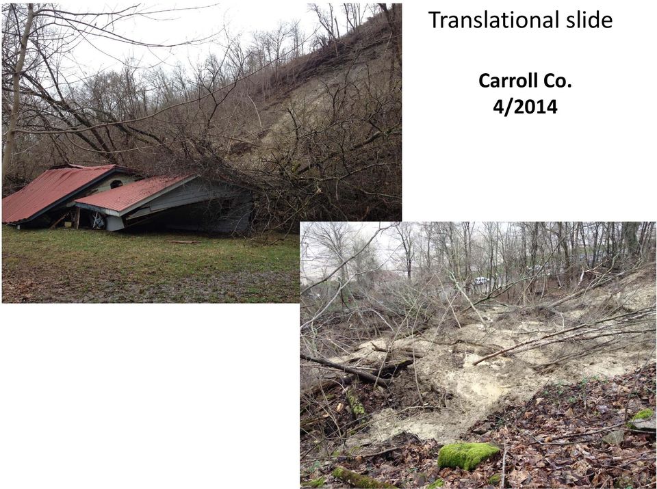
8 Translational slide Carroll Co. 4/2014
9 Carter Co.,2015

10 Campbell Co., northern KY. Recycled railroad rail

11 Rockfall, 2015 Breathitt Co., eastern KY.

12 2008 Campbell Co. Urban landslides 2011

13 2015 Landslides, YTD

14 Precipitation departure for first half of year 8 to 15 Rainfall YTD, 39.3 in Jackson, KY March April totals 13.3 Johnson Co 13.3 Knox Co July 2015, wettest on record 9.73 in Johnson Co in London, KY.

15 ~100 landslides to date Debris flows Slumps Rockslides Rockfalls Road washouts Haywood Branch, Floyd Co., eastern KY.

16 Haywood Branch, Floyd Co., eastern KY.

17 Official Hollow, Floyd Co., eastern KY.

18 Official Hollow, Floyd Co., eastern KY.

19 Little Paint Creek, Floyd Co., eastern KY.

20 Little Paint Creek, Floyd Co., eastern KY. house

21 Paintsville, Johnson Co., eastern KY.
22 Paintsville, Johnson Co., eastern KY.
23 Paintsville, Johnson Co., eastern KY.
24 Paintsville, Johnson Co.
25 Perry Co., 2015 eastern KY. Cut and fill, old landslide
26 Pike Co., eastern KY. Debris flow; destroyed church and damaged home
27 Research and Data Delivery
28 Landslide Inventory Database Known landslide locations Areas susceptible to debris flows Various sources Various attributes Number of Landslides Slope Angle (Degrees) Total = 2,443 Landslide Inventory Database Geologic Formation Landslides Pikeville Formation 474 Kope Formation 334 Hyden Formation 285 Landslide deposits 186 Four Corners Formation 156 Grundy Formation 68 Fairview Formation 62 Clays Ferry Formation 43 Princess Formation 53 Bull Fork Formation 27 Borden Formation 21 Paragon Formation 19
29 KGS Landslide Information Map Known landslide locations Areas susceptible to debris flows Landslides located from LiDAR and aerial photography LiDAR hillshade layer (where available) Create highly customized maps
30 Landslide Information Map Landslide attributes Source desc SourceID County Quad Latitude83 Longitude83 Route Date Observed Failure Date Field Checked Material Failure Type Track Length Width Head scarp height Slip surface depth Geomorphic position Bedrock Formation Failure location Contributing factor Damage Comments
31 Research Projects Geologic, geotechnical, geophysical landslide investigations Landslide characterization Groundwater conditions Soil moisture, suction, pore pressures Rainfall data Slide movement Electrical resistivity Lab data Index properties Shear strength Doe Run Lake Herron Hill Meadowview Robert s Bend
32 Meadowview Landslide Boyd Co., northeastern KY. Landslide characterization Piezometers Inclinometers Electrical resistivity
33 Doe Run Landslide, Kenton County
34 Rainfall Matric suction Vol. water content From Sorbino and Nicotera, 2013
35 Inverted electrical resistivity sections, Herron Hill landslide July 2014 Clay shale, soft failure zone? Weathered shale March 2015 Need more time lapse ER data
36 Use the extended Mohr Coulomb failure criterion to calculate unsaturated soil stress state variables From Devita and others, 2012
37 What is a heavy downpour? A 2 day precip total that is exceeded on avg. once in a 5 yr period. Source: Kenneth Kunkel, National Climate Assessment, Cooperative Institute for Climate and Satellites NC
38 Summary Landslides in Kentucky damage roadways and infrastructure with mitigation costing millions of dollars per year in damages KGS landslide inventory and map service assists investigations and allows for better determination of where future landslides may occur Matt Crawford KGS conducts research projects investigating hydrologic conditions, movement, and structure, and how geophysics may be used as a tool to support slope stability assessments.
Tool 2.3.1: General information on the causes of rainfall-induced landslides
 Impacts of Climate Change on Urban Infrastructure & the Built Environment A Toolbox Tool 2.3.1: General information on the causes of rainfall-induced landslides Author G. Dellow Affiliation GNS Science,
The correct answers are given below. Some talking points have been added for the teachers use.
 Natural Resources Canada 2011: Lesson Plan Grades 11 and 12 Landslide activity 5b: Landslides in Canada quiz Description: This is an independent study activity for grades 11 and 12. Students will read
Landslides: The Poor Stepchild of GeoHazards; What We and Other Countries Can Do to Solve It! Scott Burns Portland State University Dept.
 Landslides: The Poor Stepchild of GeoHazards; What We and Other Countries Can Do to Solve It! Scott Burns Portland State University Dept. of Geology Afghanistan: 2014: 2700 dead West Salt Creek Landslide,
HOMEOWNER S GUIDE. to LANDSLIDES. and MITIGATION RECOGNITION, PREVENTION, CONTROL, Compiled by Dr. Scott F. Burns Tessa M. Harden Carin J.
 HOMEOWNER S GUIDE to LANDSLIDES RECOGNITION, PREVENTION, CONTROL, and MITIGATION Compiled by Dr. Scott F. Burns Tessa M. Harden Carin J. Andrew Federal Emergency Management Agency Region 10 If you are
ARkStorm: California s Other Big One!
 ARkStorm: California s Other Big One! Understanding the Impacts of Massive Winter Storms Mark Jackson Meteorologist in Charge NOAA/National Weather Service Los Angeles/Oxnard What is ARkStorm? Emergency-preparedness
Landslides & Mudflows
 1 2 - What is a Landslide? - Geologic hazard Common to almost all 50 states Annual global Billions in losses Thousands of deaths and injuries 3 1 - What is a Landslide? - Gravity is driving force Some
Keynote 2: What is Landslide Hazard? Inventory Maps, Uncertainty, and an Approach to Meeting Insurance Industry Needs
 Keynote 2: What is Landslide Hazard? Inventory Maps, Uncertainty, and an Approach to Meeting Insurance Industry Needs Jeffrey R Keaton Richard J Roth, Jr Amec Foster Wheeler Los Angeles, USA Consulting
Growth Faulting, Associated Geologic Hazards, Economic & Regulatory Impact, and Methods of Investigation for the Houston, Texas Area
 Growth Faulting, Associated Geologic Hazards, Economic & Regulatory Impact, and Methods of Investigation for the Houston, Texas Area GSA / AEG-Tx Growth Fault Symposium Texas A&M University, College Station,
Flash Flood Science. Chapter 2. What Is in This Chapter? Flash Flood Processes
 Chapter 2 Flash Flood Science A flash flood is generally defined as a rapid onset flood of short duration with a relatively high peak discharge (World Meteorological Organization). The American Meteorological
INSURANCE FOR LANDSLIDE DAMAGE: THINKING OUTSIDE THE SHEAR BOX
 INSURANCE FOR LANDSLIDE DAMAGE: THINKING OUTSIDE THE SHEAR BOX Richard J. Roth, Jr. 1 and Jeffrey R. Keaton 2 1 Consulting Actuary, Huntington Beach, California, USA (e-mail: rothjr@ix.netcom.com) 2 MACTEC
WEATHERING, EROSION, AND DEPOSITION PRACTICE TEST. Which graph best shows the relative stream velocities across the stream from A to B?
 NAME DATE WEATHERING, EROSION, AND DEPOSITION PRACTICE TEST 1. The diagram below shows a meandering stream. Measurements of stream velocity were taken along straight line AB. Which graph best shows the
Geology and Geohazards in Western North Carolina
 Geology and Geohazards in Western North Carolina Rick Wooten Jennifer Bauer Stephen Fuemmeler Tommy Douglas Anne Witt Ken Gillon Rebecca Latham North Carolina Geological Survey North Carolina Geological
GEOTECHNICAL ISSUES OF LANDSLIDES CHARACTERISTICS MECHANISMS PREPARDNESS: BEFORE, DURING AND AFTER A LANDSLIDE QUESTIONS FOR DISCUSSIONS
 GEOTECHNICAL ISSUES OF LANDSLIDES CHARACTERISTICS MECHANISMS PREPARDNESS: BEFORE, DURING AND AFTER A LANDSLIDE QUESTIONS FOR DISCUSSIONS Huge landslide Leyte, Phillipines, 1998 2000 casulties Small debris
4.11 Geologic and Soil Resources
 4.11 Geologic and Soil Resources Geology and soils are evaluated as part of an environmental document because conditions in the project area can influence the type and size of a project s structure, the
 1 2 A very short description of the functional center network: regarding the Hydraulic and Hydrogeological risk, the national alert system is ensured by the National Civil Protection Department (DPCN),
CHAPTER 9 CONCLUSIONS AND RECOMMENDED MITIGATION
 CHAPTER 9 CONCLUSIONS AND RECOMMENDED MITIGATION 9.1 Conclusions Based on the stability cross-sections down the SE flank of Snodgrass Mountain, most landslides on low- to moderate-gradient slopes have
Oso Landslide, Washington March 22, 2014. Compiled by Scott Burns Portland State
 Oso Landslide, Washington March 22, 2014 Compiled by Scott Burns Portland State Monday, March 31, 2014 Snohomish County Oso is highlighted DETAILS 29 Dead; 13 missing 49 houses destroyed (25 full time
Disaster Risk Management: prevention and urgent repair procedures for infrastructure and facilities
 Disaster Risk Management: prevention and urgent repair procedures for infrastructure and facilities Jacob Greenstein Ph.D, PE, EGAT/ I&E EGAT workshop-december 2009 1 Natural disasters-new trends Natural
Les mouvements de terrain
 Centre Européen sur les Risques Géomorphologiques Les mouvements de terrain Études de cas : Glissements du Pays d Auge Prof. Olivier MAQUAIRE Faculté de Géographie, Université de Caen Basse-Normandie Laboratoire
Rafi Ahmad & Parris Lyew-Ayee
 Challenges with Spatial Information in the Caribbean Rafi Ahmad & Parris Lyew-Ayee Mona GeoInformatics Institute The University of the West Indies at Mona, Jamaica Challenges associated with: Data availability
AASHTO 2015 EXTREME WEATHER SESSIONS
 AASHTO 2015 EXTREME WEATHER SESSIONS AASHTO S CONFERENCE ON 21ST CENTURY MOBILITY FOR FREIGHT AND PASSENGER TRANSPORTATION BREAKOUT 6: FLOODING, VULNERABILITY AND RISK, OH MY! JULY 8, 2015 4:00 5:30 PM
Flood Emergency Response Planning: How to Protect Your Business from a Natural Disaster RIC005
 Flood Emergency Response Planning: How to Protect Your Business from a Natural Disaster RIC005 Speakers: Tom Chan, CEO, Global Risk Miyamoto Greg Bates, Principal, Global Risk Consultants Learning Objectives
Graduate School of Disaster Prevention Kangwon National University. http://college.kangwon.ac.kr/prevention/main.jsp
 Graduate School of Disaster Prevention Kangwon National University 1joongang-Ro Samcheok-city, Gangwon-Do, Republic of Korea http://college.kangwon.ac.kr/prevention/main.jsp Outline Natural disasters such
BRIDGE RESTORATION AND LANDSLIDE CORRECTION USING STRUCTURAL PIER AND GRADE BEAM
 BRIDGE RESTORATION AND LANDSLIDE CORRECTION USING STRUCTURAL PIER AND GRADE BEAM Swaminathan Srinivasan, P.E., M.ASCE H.C. Nutting/Terracon David Tomley, P.E., M.ASCE KZF Design Delivering Success for
Utah State General Records Retention Schedule SCHEDULE 1 GEOSPATIAL DATA SETS
 Utah State General Records Retention Schedule SCHEDULE 1 BIOTA RECORDS (Item 1-26) These are geospatial records that depict wildlife use areas in the state of Utah as determined by wildlife biologists
Rockfall in Ohio An Update of the Rockfall Database Population. Eric Kistner Stantec August 1, 2012 Geohazards Conference
 Rockfall in Ohio An Update of the Rockfall Database Population Eric Kistner Stantec August 1, 2012 Geohazards Conference Presentation Outline Rockfall in Ohio An Update of the Rockfall Database Population
METHODOLOGY FOR LANDSLIDE SUSCEPTIBILITY AND HAZARD MAPPING USING GIS AND SDI
 The 8th International Conference on Geo-information for Disaster Management Intelligent Systems for Crisis Management METHODOLOGY FOR LANDSLIDE SUSCEPTIBILITY AND HAZARD MAPPING USING GIS AND SDI T. Fernández
Climate of Illinois Narrative Jim Angel, state climatologist. Introduction. Climatic controls
 Climate of Illinois Narrative Jim Angel, state climatologist Introduction Illinois lies midway between the Continental Divide and the Atlantic Ocean, and the state's southern tip is 500 miles north of
Disaster Mitigation of Debris Flows, Slope Failures and Landslides 639
 Disaster Mitigation of Debris Flows, Slope Failures and Landslides 639 Anthropogenic Caused Mass Movements and their Impact on Railway Lines in Austria Christian Rachoy 1) and Manfred Scheikl 2) 1) Dept.
LANDSLIDE INVENTORIES IN WASHINGTON STATE: THE PAST, PRESENT, AND FUTURE
 LANDSLIDE INVENTORIES IN WASHINGTON STATE: THE PAST, PRESENT, AND FUTURE AEG Professional Forum on Landslides February 26-28, 2015 Stephen Slaughter, LEG Hazards geologist Division of Geology and Earth
Jackson Gulch Outlet Canal Rehabilitation Project
 Jackson Gulch Outlet Canal Rehabilitation Project Preliminary Budgetary Estimate for Rehabilitation February 2004 Prepared for the Mancos Water Conservancy District Jackson Gulch Reservoir 42888 County
CRS 610 Ventura County Flood Warning System Website
 CRS 610 Ventura County Flood Warning System Website Purpose This document gives instructions and a description of the information available via the Ventura County Watershed Protection District s (VCWPD)
Site C Clean Energy Project Topic Specific Sessions: Presentation by Natural Resources Canada
 Site C Clean Energy Project Topic Specific Sessions: Presentation by Natural Resources Canada Fort St. John, British Columbia January 13, 2014 Outline 1. Context for NRCan s Participation in the Joint
HAZARD RISK ASSESSMENT, MONITORING, MAINTENANCE AND MANAGEMENT SYSTEM (HAMMS) FOR LANDSLIDE AND FLOOD. Mohd. Nor Desa, Rohayu and Lariyah, UNITEN
 FOR LANDSLIDE AND FLOOD. Mohd. Nor Desa, Rohayu and Lariyah, UNITEN") HAZARD RISK ASSESSMENT, MONITORING, MAINTENANCE AND MANAGEMENT SYSTEM (HAMMS) FOR LANDSLIDE AND FLOOD Mohd. Nor Desa, Rohayu and Lariyah, UNITEN WHAT WE HAVE IN MIND AND FROM OUR PREVIOUS PROJECT CONTRIBUTION
HAZARD RISK ASSESSMENT, MONITORING, MAINTENANCE AND MANAGEMENT SYSTEM (HAMMS) FOR LANDSLIDE AND FLOOD Mohd. Nor Desa, Rohayu and Lariyah, UNITEN WHAT WE HAVE IN MIND AND FROM OUR PREVIOUS PROJECT CONTRIBUTION
SBA Disaster Assistance Program
 SBA Disaster Assistance Program Our mission is to provide low-interest disaster loans to businesses of all sizes, private nonprofit organizations, homeowners and renters to repair or replace real estate,
Catchment Scale Processes and River Restoration. Dr Jenny Mant Jenny@therrc.co.uk. The River Restoration Centre therrc.co.uk
 Catchment Scale Processes and River Restoration Dr Jenny Mant Jenny@therrc.co.uk The River Restoration Centre therrc.co.uk 3 Main Catchment Elements Hydrology Energy associated with the flow of water affects
State of the Art of Landslide Site Monitoring in Europe: Preliminary Results of the SafeLand Questionnaire
 Ber. Geol. B. A., 82, ISSN 1017 8880 Landslide Monitoring Technologies & Early Warning Systems State of the Art of Landslide Site Monitoring in Europe: Preliminary Results of the SafeLand Questionnaire
Engineering Geological Asset Management for Large Dams. Yasuhito SASAKI (1)
") Engineering Geological Asset Management for Large Dams Yasuhito SASAKI (1) (1) Geology Research Team, Public Works Research Institute, Japan E-mail:ya-sasa@pwri.go.jp Abstract Comprehensive inspection
Engineering Geological Asset Management for Large Dams Yasuhito SASAKI (1) (1) Geology Research Team, Public Works Research Institute, Japan E-mail:ya-sasa@pwri.go.jp Abstract Comprehensive inspection
(ChLRJIS 4 Hazard Identification, Assessment, and Mapping
 (ChLRJIS 4 Hazard Identification, Assessment, and Mapping Hazard Analysis Recognition of the presence of active or potential slope movement, and of the types and causes of the movement, is essential to
Landslide hazard zonation using MR and AHP methods and GIS techniques in Langan watershed, Ardabil, Iran
 Landslide hazard zonation using MR and AHP methods and GIS techniques in Langan watershed, Ardabil, Iran A. Esmali Ouri 1* S. Amirian 2 1 Assistant Professor, Faculty of Agriculture, University of Mohaghegh
USSD Workshop on Dam Break Analysis Applied to Tailings Dams
 USSD Workshop on Dam Break Analysis Applied to Tailings Dams Antecedents Newtonian / non-newtonian flows Available models that allow the simulation of non- Newtonian flows (tailings) Other models used
Web Based Real Time Monitoring System Along North-South Expressway, Malaysia
 Web Based Real Time Monitoring System Along North-South Expressway, Malaysia Low Tian Huat Mohd Asbi & Associates, Malaysia; malvinlth@gmail.com Faisal Ali Department of Civil Engineering, Faculty of Engineering,
THE OBJECTIVES OF ROUTINE ROAD CUTS AND FILLS
 Chapter 11 Slope Stabiliza bilization and Stability of Cuts and Fills THE OBJECTIVES OF ROUTINE ROAD CUTS AND FILLS are 1) to create space for the road template and driving surface; 2) to balance material
The Live Land Project ARTES Applications Workshop 19 th April 2013
 The Live Land Project ARTES Applications Workshop 19 th April 2013 Contents 1. Overview of project, expected outputs and benefits 2. ESA, Industry Partners and Clients involvement 3. Outline of programme
Climate Extremes Research: Recent Findings and New Direc8ons
 Climate Extremes Research: Recent Findings and New Direc8ons Kenneth Kunkel NOAA Cooperative Institute for Climate and Satellites North Carolina State University and National Climatic Data Center h#p://assessment.globalchange.gov
The Caribbean Disaster Mitigation Project: Supporting Sustainable Responses to Natural Hazards
 The Caribbean Disaster Mitigation Project: Supporting Sustainable Responses to Natural Hazards Steven Stichter Caribbean Disaster Mitigation Project (CDMP) Unit of Sustainable Development and Environment
7 Why are Landslides a Threat to City of San Dimas?
 7 Why are Landslides a Threat to City of San Dimas? Landslides are a serious geologic hazard in almost every state in America. Nationally, landslides cause 25 to 50 deaths each year. 1 Landslide damage
REAL-TIME SLOPE AND WALL MONITORING AND REPORTING USING 3-D MEMS-BASED, IN-PLACE INCLINOMETER SYSTEM
 REAL-TIME SLOPE AND WALL MONITORING AND REPORTING USING 3-D MEMS-BASED, IN-PLACE INCLINOMETER SYSTEM Aaron J. Muck, P.E., M.ASCE Swaminathan Srinivasan (Vasan), P.E., M.ASCE H.C. Nutting/Terracon Monitored
CHAPTER 11 LANDSLIDE
 CHAPTER 11 LANDSLIDE Landslides are one of the most common geologic hazards in Wyoming, with some of the highest landslide densities in the country found within the state. The probability is high that
Social and Environmental Impacts of Landslides
 Social and Environmental Impacts of Landslides Latsis Symposium 2007 Research Frontiers in Environment and Sustainability ETH-Zurich September 18, 2007 Dr. A. Keith Turner Emeritus Professor Geological
Flood Risk Management
 Flood Risk Management Value of Flood Risk Management Every year floods sweep through communities across the United States taking lives, destroying property, shutting down businesses, harming the environment
Flood Risk Management
 Flood Risk Management Value of Flood Risk Management Value to Individuals and Communities Every year floods sweep through communities across the United States taking lives, destroying property, shutting
State Health Insurance Assistance Program (SHIP) Coordinators in Kentucky S H I P COORDINATOR
 Coordinators in Kentucky S H I P COORDINATOR") BARREN RIVER Allen Barren Butler Edmonson Hart Logan Metcalfe Monroe Simpson Warren Daniel Curry/ Linda Tate Kentucky Legal Aid 1700 Destiny Lane Bowling Green, KY 42104 (866) 452-9243 Phone: (270) 782-5740
BARREN RIVER Allen Barren Butler Edmonson Hart Logan Metcalfe Monroe Simpson Warren Daniel Curry/ Linda Tate Kentucky Legal Aid 1700 Destiny Lane Bowling Green, KY 42104 (866) 452-9243 Phone: (270) 782-5740
Town of Warwick, Village of Florida, Village of Greenwood Lake and Village of Warwick MULTI JURISIDICTIONAL, MULTI HAZARD MITIGATION PLAN DRAFT
 Town of Warwick, Village of Florida, Village of Greenwood Lake and Village of Warwick MULTI JURISIDICTIONAL, MULTI HAZARD MITIGATION PLAN DRAFT Appendix B Historical Hazard Documentation Rev #0 May 2013
KHATRI STRUCTURAL AND CIVIL ENGINEERS
 TABLE OF CONTENTS SECTION TITLE 1.0 INTRODUCTION AND EXECUTIVE SUMMARY 2.0 PROJECT TEAM 3.0 EXPERIENCE AND PROJECTS 4.0 PHOTO CREDITS 2 Page 1.0 INTRODUCTION AND EXECUTIVE SUMMARY We are pleased to introduce
Managing North Carolina's MSE Wall Assets through Design, Construction and Performance
 Managing North Carolina's MSE Wall Assets through Design, Construction and Performance Robert A. Gladstone, P.E. Executive Director Association for Metallically Stabilized Earth 2013 Early Earth Reinforcement
February 4, 2011. hoffman.stephen@epa.gov. Report Recommendations and NIPSCO Responses. 4.3 Maintaining and Controlling Vegetation Growth
 February 4, 2011 VIA E-MAIL AND CERTIFIED MAIL #7010 0290 0002 0577 6226 Mr. Stephen Hoffman US Environmental Protection Agency (5304P) 1200 Pennsylvania Avenue, NW Washington, DC 20460 hoffman.stephen@epa.gov
Landslides & Mudslides
 Landslides & Mudslides Landslides, also known as mudslides and debris flow, occur in all U.S. states and territories. In snowy mountainous areas winter snow landslides are called avalanches. Landslides
Appendix B. Introduction to Landslide Evaluation Tools Mapping, Remote Sensing, and Monitoring of Landslides
 Appendix B. Introduction to Landslide Evaluation Tools Mapping, Remote Sensing, and Monitoring of Landslides 66 The Landslide Handbook A Guide to Understanding Landslides Part 1. Mapping Maps are a useful
5.14 Floodplains and Drainage/Hydrology
 I-70 East Final EIS 5.14 Floodplains and Drainage/Hydrology 5.14 Floodplains and Drainage/Hydrology This section discusses floodplain and drainage/hydrology resources and explains why they are important
City of London Climate Change Adaptation Strategy Dealing with Extreme Rainfall Events
 City of London Climate Change Adaptation Strategy Dealing with Extreme Rainfall Events May 29, 2014 Presented by: Berta Krichker M.Eng., FEC, P.Eng. Manager of Stormwater Unit Environmental and Engineering
Settlement of Foundations on Expansive Clays Due to Moisture Demand of Trees CIGMAT 2008
 Settlement of Foundations on Expansive Clays Due to Moisture Demand of Trees CIGMAT 2008 Kenneth E. Tand, P.E. Practicing Geotechnical Engineer FRIEND OR FOE Trees are our friends. They extract carbon
HAZARD VULNERABILITY & RISK ASSESSMENT
 Hazard Vulnerability Analysis Purpose and Scope A Hazard Vulnerability Analysis (HVA) evaluates risk associated with a specific hazard. During this analysis, the hazard is evaluated for its probability
RESUME Lee A. Knuppel, P.E.
 RESUME Lee A. Knuppel, P.E. OFFICE: EDUCATION: LEE A. KNUPPEL AND ASSOCIATES, Inc. 7770 Cooper Road, Suite 7 Montgomery, Ohio 45242 (513) 793-4222 Graduate: UCLA, Los Angeles, CA M.S. in Civil Engineering,
LANDSLIDE LOSS ESTIMATION PILOT PROJECT IN OREGON
 STATE OF OREGON DEPARTMENT OF GEOLOGY AND MINERAL INDUSTRIES Suite 965, 800 NE Oregon St., #28 Portland, Oregon 97232 OPEN-FILE REPORT O-02-05 LANDSLIDE LOSS ESTIMATION PILOT PROJECT IN OREGON By Yumei
Flood After Fire Fact Sheet
 FACT SHEET Flood After Fire Fact Sheet Risks and Protection Floods are the most common and costly natural hazard in the nation. Whether caused by heavy rain, thunderstorms, or the tropical storms, the
Multi-Jurisdictional Hazard Mitigation Plan
 Flooding General Flooding is the leading cause of death among all types of natural disasters throughout the United States, with its ability to roll boulders the size of cars, tear out trees, and destroy
Sediment Supply and the Upland-Stream Connection. Brian Bledsoe Department of Civil and Environmental Engineering Colorado State University
 Sediment Supply and the Upland-Stream Connection Brian Bledsoe Department of Civil and Environmental Engineering Colorado State University Overview The sediment system (with an eye towards hillslope processes
Watersheds, Streams, & Highways: Resiliency in Disaster Recovery Through Partnerships and Innovation
 Watersheds, Streams, & Highways: Resiliency in Disaster Recovery Through Partnerships and Innovation Chris Sturm Colorado Water Conservation Board Stream Restoration Coordinator 303 866 3441 chris.sturm@state.co.us
6 RETROFITTING POST & PIER HOUSES
 Retrofitting Post & Pier Houses 71 6 RETROFITTING POST & PIER HOUSES by James E. Russell, P.E. 72 Retrofitting Post & Pier Houses Retrofitting Post & Pier Houses 73 RETROFITTING POST AND PIER HOUSES This
Section 19. Basin-wide Mitigation Action Plans
 Section 19. Basin-wide Mitigation Action Plans This Mitigation Plan identifies twelve specific hazards that could affect the Basin. Section 20 of this Plan set forth mitigation action plans to be carried
Climate Change in North Carolina
 Climate Change in North Carolina Dr. Chip Konrad Director of the The Southeast Regional Climate Center Associate Professor Department of Geography University of North Carolina at Chapel Hill The Southeast
Numerical Modeling and Simulation of Extreme Flood Inundation to Assess Vulnerability of Transportation Infrastructure Assets
 Numerical Modeling and Simulation of Extreme Flood Inundation to Assess Vulnerability of Transportation Infrastructure Assets 2015 University Transportation Center (UTC) Conference for the Southeastern
INITIAL SITE INSPECTION OF MOTORCYCLE COLLISIONS WITH ROADSIDE OBJECTS IN NEW JERSEY
 INITIAL SITE INSPECTION OF MOTORCYCLE COLLISIONS WITH ROADSIDE OBJECTS IN NEW JERSEY Allison Daniello Ben Powell Nicholas Schaeffer Aaliyah McClinton Yusuf Mehta Rowan University United States Kimberly
Safety of Small/Rural Dams and Barrier Lake Management
 Safety of Small/Rural Dams and Barrier Lake Management A. Introduction 1. Lessons learnt and recommendations are provided for artificial dams and barrier lakes. In the case of artificial dams, emphasis
Engineering Group Working Party Report
 GEOLOGICAL SOCIETY ENGINEERING GEOLOGY SPECIAL PUBLICATION NO. 25 Hot Deserts: Engineering, Geology and Geomorphology Engineering Group Working Party Report EDITED BY M. J. WALKER Consultant, Berkshire,
FINAL PLAN OF REMEDIAL ACTION
 FINAL PLAN OF REMEDIAL ACTION 1000 FRENCH STREET SITE Wilmington, Delaware DE 1115 June 1999 Department of Natural Resources and Environmental Control Division of Air and Waste Management Site Investigation
Scour and Scour Protection
 Design of Maritime Structures Scour and Scour Protection Steven A. Hughes, PhD, PE Coastal and Hydraulics Laboratory US Army Engineer Research and Development Center Waterways Experiment Station 3909 Halls
APPENDIX A : 1998 Survey of Proprietary Risk Assessment Systems
 APPENDIX A : 1998 Survey of Proprietary Risk Assessment Systems In its 1997 paper, the working party reported upon a survey of proprietary risk assessment systems designed for use by UK household insurers
The AIR Inland Flood Model for the United States In Spring 2011, heavy rainfall and snowmelt produced massive flooding along the Mississippi River,
 The AIR Inland Flood Model for the United States In Spring 2011, heavy rainfall and snowmelt produced massive flooding along the Mississippi River, inundating huge swaths of land across seven states. As
Chapter 4 SUBSURFACE INVESTIGATION GUIDELINES
 Chapter 4 SUBSURFACE INVESTIGATION GUIDELINES Final SCDOT GEOTECHNICAL DESIGN MANUAL August 2008 Table of Contents Section Page 4.1 Introduction...4-1 4.2 Subsurface Investigation...4-2 4.2.1 Preliminary
DPAC- DLGSEM and MRT. Landslide planning matrix
 DPAC- DLGSEM and MRT Landslide planning matrix Thank you to MRT, council planners, and the TPC for their support in this work DPAC- DLGSEM and MRT Process thus far Regional workshops (April May) Follow
KET Cable and Satellite Company Channel Listings Updated December 2012
 NOTE: Companies serving larger cities are listed first, followed by an alphabetical listing of smaller cable companies. INSIGHT COMMUNICATIONS (LOUISVILLE/KENTUCKIANA) 15 KET2 189 KET 190 KET2 192 KET
(1) Discuss the determination of the need for public visitation. Visitor center density within 100 miles.
 Discuss the determination of the need for public visitation. Visitor center density within 100 miles.") Chapter 4 Specifications Designs 3. Visitors Centers 3. Visitors Centers. The Introduction (Chapter 1) for these design data collection guidelines contains additional information concerning: preparing
Chapter 4 Specifications Designs 3. Visitors Centers 3. Visitors Centers. The Introduction (Chapter 1) for these design data collection guidelines contains additional information concerning: preparing
2013 Annual Climate Summary for the Southeast United States
 Months of heavy rain forced the U.S. Army Corp of Engineers to open the spillways at Lake Hartwell, located at the headwaters of the Savannah River along the South Carolina-Georgia border, on July 9,.
Geographical Information Systems (GIS) and Economics 1
 and Economics 1") Geographical Information Systems (GIS) and Economics 1 Henry G. Overman (London School of Economics) 5 th January 2006 Abstract: Geographical Information Systems (GIS) are used for inputting, storing,
Geographical Information Systems (GIS) and Economics 1 Henry G. Overman (London School of Economics) 5 th January 2006 Abstract: Geographical Information Systems (GIS) are used for inputting, storing,
The Hydrologic Cycle. precipitation evaporation condensation transpiration infiltration surface runoff transport groundwater water table.
 The Hydrologic Cycle Page 1 of 1 Name Directions: The hydrologic cycle consists of the processes that change and move water through the earth s system. Use the terms below to label the hydrologic cycle.
Nowcasting: analysis and up to 6 hours forecast
 Nowcasting: analysis and up to 6 hours forecast Very high resoultion in time and space Better than NWP Rapid update Application oriented NWP problems for 0 6 forecast: Incomplete physics Resolution space
List of Graduate Level Courses in Civil Engineering
 List of Graduate Level Courses in Civil Engineering Students should visit the York University courses web site for a listing of courses being offered (https://w2prod.sis.yorku.ca/apps/webobjects/cdm) during
Vermont Economic Resiliency Initiative (VERI) Community Forum Barre City & Barre Town
 Community Forum Barre City & Barre Town") Vermont Economic Resiliency Initiative (VERI) Community Forum Barre City & Barre Town MEETING NOTES April 16, 2015 6:00 8:00 PM VERI Project Overview With funding from the US Economic Development Administration
Vermont Economic Resiliency Initiative (VERI) Community Forum Barre City & Barre Town MEETING NOTES April 16, 2015 6:00 8:00 PM VERI Project Overview With funding from the US Economic Development Administration
National Disaster Management Institute
 National Disaster Management Institute CONTENTS one Cause of Urban Flood Disaster two Urban Flood Damage Case three Disaster Prevention Measures for Future Urban Flood four NDMI s Measures & Strategy for
MANAGING LANDSLIDE HAZARDS FROM THE WHAKATĀNE AND ŌHOPE ESCARPMENTS
 MANAGING LANDSLIDE HAZARDS FROM THE WHAKATĀNE AND ŌHOPE ESCARPMENTS Summary - Landslide Risk Study & Management Options www.whakatane.govt.nz July 20 13 INTRODUCTION 2 SUMMARY 3 GEOLOGY AND LANDSLIDE FORMATION
Kentucky Transportation Center
 Kentucky Transportation Center Research Report KTC -13-13/KSP2-11-1F Analysis of Traffic Crash Data in Kentucky (2008-2012) Our Mission We provide services to the transportation community through research,
DAMAGE TO FOUNDATIONS FROM EXPANSIVE SOILS
 DAMAGE TO FOUNDATIONS FROM EXPANSIVE SOILS J. David Rogers, Robert Olshansky, and Robert B. Rogers Expansive soils in many parts of the United States pose a significant hazard to foundations for light
Strategies for mitigation of risk associated with landslides
 Strategies for mitigation of risk associated with landslides Farrokh Nadim 1 & Suzanne Lacasse 2 1 Director, International Centre for Geohazards / NGI, Oslo, Norway 2 Managing Director, Norwegian Geotechnical
ROSE CREEK WATERSHED HYDROLOGIC, HYDRAULIC, SEDIMENT TRANSPORT, AND GEOMORPHIC ANALYSES TASK 1 EXISTING DATA AND INFORMATION SUMMARY REPORT BACKGROUND
 ROSE CREEK WATERSHED HYDROLOGIC, HYDRAULIC, SEDIMENT TRANSPORT, AND GEOMORPHIC ANALYSES TASK 1 EXISTING DATA AND INFORMATION SUMMARY REPORT BACKGROUND The Rose Creek Watershed (RCW) consists of three planning
7.0 Stream Restoration
 7.0 Stream Restoration 7.1 Issue Statements One of the primary concerns of residents in the Bassett Creek watershed is the maintenance of the natural beauty of the creek in residential and recreational
32 Contingencies MAR/APR.06
 32 Contingencies MAR/APR.06 New Catastrophe Models for Hard Times B Y P A T R I C I A G R O S S I A N D H O W A R D K U N R E U T H E R Driven by the increasing frequency and severity of natural disasters
Sustainable Road Drainage Asset Management Strategy and Financial Requirements
 Sustainable Road Drainage Asset Management Strategy and Financial Requirements Liane Welch, P.E., Director, Tillamook County Public Works Patricia Bugas-Schramm, PBS Consulting Jeff Roorda, P.E., JRA TRB
Leica Monitoring Solutions. Leica Monitoring Solutions Certainty builds confidence.
 Leica Monitoring Solutions Leica Monitoring Solutions Certainty builds confidence. Risk and Cost Reduction Proven Solutions Facing new challenges Engineering companies and contractors are facing challenges