Oso Landslide, Washington March 22, Compiled by Scott Burns Portland State
|
|
|
- Timothy Preston
- 8 years ago
- Views:
Transcription
1 Oso Landslide, Washington March 22, 2014 Compiled by Scott Burns Portland State Monday, March 31, 2014

2
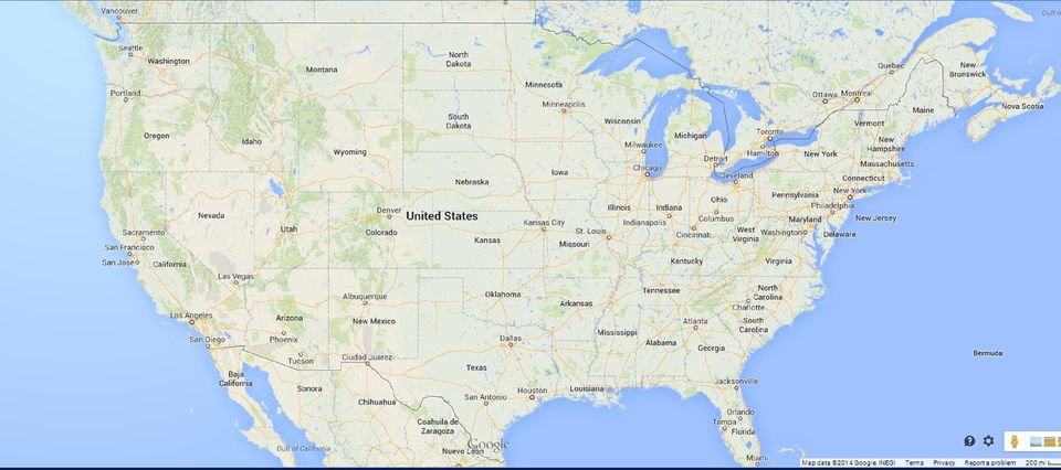
3 Snohomish County Oso is highlighted

4 DETAILS 29 Dead; 13 missing 49 houses destroyed (25 full time occupants) 55 miles NE of Seattle Losses: $7 million houses $3 million house contents 32 million rescue/emergency response $22 million to remove debris

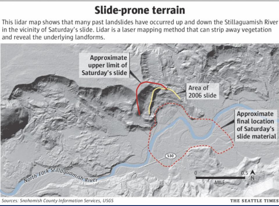
5 Geology of the Landslide Glacial-Fluvial Deposits of the Hazel Formation Plateau Whitman Bench Previous Landslides at the site: 1951, 1967, 1988, 2006 Landslide 300 acres debris field Volume: 15 million cubic yards Classification: Debris Avalanche/Debris Flow (Dick Iverson) Toxic debris and gas tanks
 Toxic debris")
6 Factors Affecting the Landslide Steep Slope Weak soils Near record rainfall March was twice normal amount River undercutting the base of the slope at the meander bend while it was flooding Small change is slope hydrology from clear cutting of trees at top of slope

7 Most Deadly American Landslides a) 1928: St. Francis Dam, California: 500 b) 1985: Mameyes, Puerto Rico (Hurricane Isabel): 129 c) 1980: Mt. St. Helens (not all from landslide) 57 d) 2014: Oso Washington (24 dead + 22missing) 46 e) 1959: Madison Canyon, Montana 29 f) 2005: La Conchita, California 10 g) 1974: Canyonville, Oregon 9 One event over many valleys killed 150 in 1969 from Hurricane Camille in Nelson County, Virginia from debris flows. Source: Lynn Highland
 2005: La Conchita, California 10 g) 1974: Canyonville, Oregon 9 One event over many valleys killed 150 in 1969")
8 Chronology of events on the Oso landslide 1949: A large landslide (1000 feet long and 2600 feet wide) affected the river bank 1951: Another large failure of the slope; the river was partially blocked 1967: Seattle Times published an article that referred to this site as Slide Hill 1997: report, by Daniel Miller, for the Washington Department of Ecology and the Tualialip Tribes 1999: US Army Corps of Engineers report by Daniel and Lynne Rodgers Miller that warned of the potential for a large catastrophic failure 2006: January 25: large movement of the Steelhead landslide blocked the river Source: The Yakima Herald

9
10 On the hillside overlooking what was Oso Source: Jim Wilson/ The New York Times

11 March 24, landslide blocks river

12

13
14

15

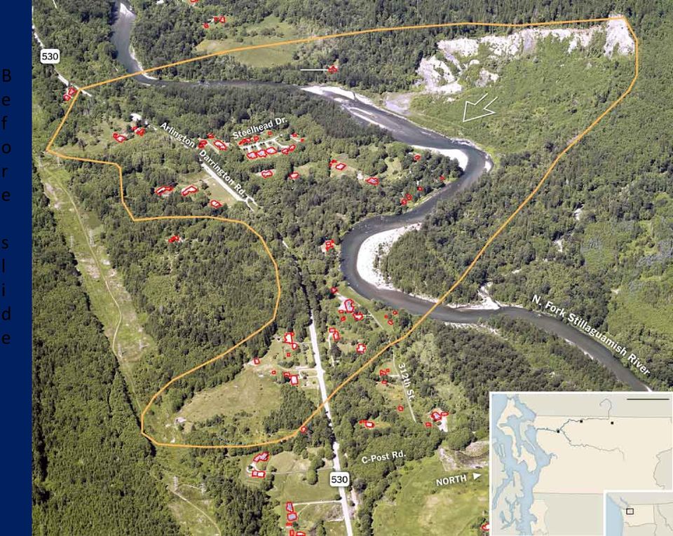
16 Stillaguamish River (North Fork), site of the March 22, 2014, Oso mudslide; the unstable area is covered with red alder, bigleaf maple and black cottonwood (light green) forest (right of center and below river). An eroding slope on the far side of the unstable area was left by a smaller slide that briefly dammed the river on January 25, 2006, and by similar previous events. The mudslide flowed to the upper left, across the river into the Steelhead Drive area. Most, if not all, of the houses visible in the image were destroyed. Source: Wikipedia

17

18 B e f o r e s l i d e
19

20 Source: Dr. Jeff Master s Wunder Blog

21 Source: CNN
22 Jan.,
23 Oso landslide Source: Wikipedia
24
25 Readings from the Pacific Northwest Seismic Network reveal that the hillside collapsed in two stages: The lower part of the slope gave way at 10:37 a.m. PT, triggering seismic activity that lasted two and a half minutes. That material could have been disturbed and weakened by a landslide that occurred in 2006
26 The landslide cut off the small town of Darrington and prompted an evacuation notice for fear of a potentially catastrophic flood event
27
28 Washington State Patrol trooper arrives on the scene on March 22, 2014
29
30 March 30, 2014
31 Search and rescue on March 26, 2014
32 March 25, 2014
33 King County Sheriff s Office helicopter lowers a rescue worker on March 24, 2014
34 Downed power lines in debris on March 23, 2014
35 March 29, 2014
36 Near Darrington, March 29, 2014
37 Air National Guard, Staff Sgt. Jonathon Hermas, almost waist deep in debris still searching March 29, 2014
38 March 25, 2014
39 March 25, 2014
40 Emergency vehicles fill State Route 530 on March 26, 2014
41 March 27, 2014
42 March 27, 2014
43 Searchers pause for moment of silence for victims on March 29, 2014
44 March 29, 2014
45 Moment of Silence March 29, 2014
46 March 29, 2014
47 Volunteers help with search, March 24, 2014
48 March 22, 2014
49
50
51 Clear Cutting on the Whitman Bench 2005: a pizza pie shape of 7.5 acres cut with the tip touching the slope Boundaries based on the 1988 report, not the 2006 report (5 acres would have been protected using the 2006 Miller report)
52 GEER: Geotechnical Extreme Events Reconnaissance Joseph Wartman, Geotech Professor, Univ. of Washington Jeff Keaton, AMEC David Mongomery, Geology Professor, Univ. of Washington John de LaChapelle, Golder Associates Scott Anderson, Federal Highways This banner committee will be researching the causes and put together a report
53 Future Counties: communications needed between maps and planners Counties: need landslide susceptibility maps Insurance: need landslide insurance or all hazard insurance like New Zealand
54 Post-landslide LiDAR (courtesy of Dr. Scott Anderson) An intact house sits at the edge of the landslide on March 24, 2014
Landslides: The Poor Stepchild of GeoHazards; What We and Other Countries Can Do to Solve It! Scott Burns Portland State University Dept.
 Landslides: The Poor Stepchild of GeoHazards; What We and Other Countries Can Do to Solve It! Scott Burns Portland State University Dept. of Geology Afghanistan: 2014: 2700 dead West Salt Creek Landslide,
Landslides. Landslides-1. March 2007
 Landslides Learn if landslides, including debris flows, could occur in your area by contacting local officials, your state geological survey or department of natural resources, or the geology department
HOMEOWNER S GUIDE. to LANDSLIDES. and MITIGATION RECOGNITION, PREVENTION, CONTROL, Compiled by Dr. Scott F. Burns Tessa M. Harden Carin J.
 HOMEOWNER S GUIDE to LANDSLIDES RECOGNITION, PREVENTION, CONTROL, and MITIGATION Compiled by Dr. Scott F. Burns Tessa M. Harden Carin J. Andrew Federal Emergency Management Agency Region 10 If you are
Wildfire & Flash Flood Recovery Emergency Watershed Protection (EWP) Flood Mitigation Efforts April 2014. Fall 2013
 Flood Mitigation Efforts April 2014. Fall 2013") Wildfire & Flash Flood Recovery Emergency Watershed Protection (EWP) Flood Mitigation Efforts April 2014 Fall 2013 Recovery Specific to Incident Recovery Efforts Depend on: Population Impacted Topography
Wildfire & Flash Flood Recovery Emergency Watershed Protection (EWP) Flood Mitigation Efforts April 2014 Fall 2013 Recovery Specific to Incident Recovery Efforts Depend on: Population Impacted Topography
Landslides & Mudflows
 1 2 - What is a Landslide? - Geologic hazard Common to almost all 50 states Annual global Billions in losses Thousands of deaths and injuries 3 1 - What is a Landslide? - Gravity is driving force Some
Wildfire & Flash Flood Recovery NACo Justice & Public Safety Symposium January 2014
 Wildfire & Flash Flood Recovery NACo Justice & Public Safety Symposium January 2014 Fall 2013 Jim Reid Executive Director Public Service El Paso County, Colorado Recovery Specific to Incident Recovery
Landslides & Mudslides
 Landslides & Mudslides Landslides, also known as mudslides and debris flow, occur in all U.S. states and territories. In snowy mountainous areas winter snow landslides are called avalanches. Landslides
Landslide Briefing to City Council April 28, 2014
 Landslide Briefing to City Council April 28, 2014 OEM: Barb Graff DPD: Susan Chang, P.E. SPU: Nancy Ahern SDOT: Lawrence Eichhorn SFD: Chief A. D. Vickery Landslide Planning and Response History of landslides
GEOTECHNICAL ISSUES OF LANDSLIDES CHARACTERISTICS MECHANISMS PREPARDNESS: BEFORE, DURING AND AFTER A LANDSLIDE QUESTIONS FOR DISCUSSIONS
 GEOTECHNICAL ISSUES OF LANDSLIDES CHARACTERISTICS MECHANISMS PREPARDNESS: BEFORE, DURING AND AFTER A LANDSLIDE QUESTIONS FOR DISCUSSIONS Huge landslide Leyte, Phillipines, 1998 2000 casulties Small debris
DRAFT SOUTH FORK SKYKOMISH RIVER
 DRAFT SOUTH FORK SKYKOMISH RIVER 9 levees and revetments / Approximately 1.1 miles of river bank are armored Revetments provide limited, localized erosion protection, but impact habitat Frequent and costly
Flood After Fire Fact Sheet
 FACT SHEET Flood After Fire Fact Sheet Risks and Protection Floods are the most common and costly natural hazard in the nation. Whether caused by heavy rain, thunderstorms, or the tropical storms, the
Asbestos Disposal Information for Washington and Oregon
 Asbestos Disposal Information for Washington and Oregon State County Disposal Site (call for fees) Restrictions/Requirements WA CLARK Columbia Resource Company Transfer Station 11034 NE 117th Avenue Vancouver,
Jackson Gulch Outlet Canal Rehabilitation Project
 Jackson Gulch Outlet Canal Rehabilitation Project Preliminary Budgetary Estimate for Rehabilitation February 2004 Prepared for the Mancos Water Conservancy District Jackson Gulch Reservoir 42888 County
The correct answers are given below. Some talking points have been added for the teachers use.
 Natural Resources Canada 2011: Lesson Plan Grades 11 and 12 Landslide activity 5b: Landslides in Canada quiz Description: This is an independent study activity for grades 11 and 12. Students will read
The Kentucky Geological Survey Landslide Program: An Overview
 The Kentucky Geological Survey Landslide Program: An Overview Matt Crawford Kentucky Geological Survey 2015 Geohazards in Transportation August 4 6, 2015 Huntington, WV Outline National background Landslides
Arapaho & Roosevelt National Forests 2013 Flood: Long-term Recovery in a Changed Landscape
 Arapaho & Roosevelt National Forests 2013 Flood: Long-term Recovery in a Changed Landscape Spring 2014 The flood of September 2013 changed the landscape of the Boulder and Canyon Lakes Ranger Districts.
DPAC- DLGSEM and MRT. Landslide planning matrix
 DPAC- DLGSEM and MRT Landslide planning matrix Thank you to MRT, council planners, and the TPC for their support in this work DPAC- DLGSEM and MRT Process thus far Regional workshops (April May) Follow
El Nino in the OC. Orange County Sheriff s Department Emergency Management Division
 El Nino in the OC Orange County Sheriff s Department Emergency Management Division The mission of the Orange County Sheriff s Department s Emergency Management Division is to promote, facilitate, and support
Appendix B. Introduction to Landslide Evaluation Tools Mapping, Remote Sensing, and Monitoring of Landslides
 Appendix B. Introduction to Landslide Evaluation Tools Mapping, Remote Sensing, and Monitoring of Landslides 66 The Landslide Handbook A Guide to Understanding Landslides Part 1. Mapping Maps are a useful
FLOOD PROTECTION AND ECOSYSTEM SERVICES IN THE CHEHALIS RIVER BASIN. May 2010. Prepared by. for the. 2010 by Earth Economics
 FLOOD PROTECTION AND ECOSYSTEM SERVICES IN THE CHEHALIS RIVER BASIN May 2010 Prepared by for the Execubve Summary The Chehalis Basin experienced catastrophic flooding in 2007 and 2009. In response, the
Walter Dasheno Governor Santa Clara Pueblo
 Walter Dasheno Governor Santa Clara Pueblo Testimony on Current and Future Impacts of Climate Change on the Intermountain West, including Drought, Wildfire Frequency and Severity, And Ecosystems Before
ESTIMATING THE COSTS OF EMERGENCY SERVICES DURING FLOOD EVENTS
 C. Pfurtscheller R. Schwarze ESTIMATING THE COSTS OF EMERGENCY SERVICES DURING FLOOD EVENTS Funding Project Management Coordination Agenda Introduction Emergency costs State of the art Flooding of 2005
7 Why are Landslides a Threat to City of San Dimas?
 7 Why are Landslides a Threat to City of San Dimas? Landslides are a serious geologic hazard in almost every state in America. Nationally, landslides cause 25 to 50 deaths each year. 1 Landslide damage
MADISON COUNTY EMERGENCY MANAGEMENT. After Action Review of the Sheridan Quake and the Ennis 4 th of July Exercise
 MADISON COUNTY EMERGENCY MANAGEMENT After Action Review of the Sheridan Quake and the Ennis 4 th of July Exercise Directed by: Chris Mumme, Director of Emergency Management Attendees: Jill Steeley, Madison
PRESENTERS: BACHELOR OF ARTS- PSYCHOLOGY
 KIBET J. NELLY PRESENTERS: MAGAI N. DORCAS BACHELOR OF ARTS- PSYCHOLOGY DISASTER? A serious disruption of the functioning of a community or society causing widespread human, material, economic or environmental
DEPARTMENT OF THE INTERIOR U.S. GEOLOGICAL SURVEY A FRAMEWORK FOR LOSS REDUCTION
 DEPARTMENT OF THE INTERIOR U.S. GEOLOGICAL SURVEY National Landslide Hazards Mitigation Strategy A FRAMEWORK FOR LOSS REDUCTION U.S. GEOLOGICAL SURVEY OPEN-FILE REPORT 00-450 2000 ii DEPARTMENT OF THE
SURVIVAL FACTORS GROUP CHAIRMAN S FACTUAL REPORT, Revision 1 1
 National Transportation Safety Board Office of Railroad Pipeline and Hazardous Materials Investigations Human Performance and Survival Factors Division Washington, D.C. 20594 October 18, 2001 SURVIVAL
How To Check For Scour At A Bridge
 Case Studies Bridge Scour Inspection and Repair Edward P. Foltyn, P.E. Senior Hydraulic Engineer ODOT Bridge Unit 2013 PNW Bridge Inspectors Conference April 2013 REFERENCES Stream Stability at Highway
Tool 2.3.1: General information on the causes of rainfall-induced landslides
 Impacts of Climate Change on Urban Infrastructure & the Built Environment A Toolbox Tool 2.3.1: General information on the causes of rainfall-induced landslides Author G. Dellow Affiliation GNS Science,
Emergency Management
 LESSON PLAN 5 Be Disaster Safe Learning that there is a system in place and that agencies cooperate to take care of the community s needs during emergencies and disasters reassures and supports students.
2013 State of Arizona Hazard Mitigation Plan State and County Descriptions
 Mohave County History / Geography Mohave County is located in northwest corner of Arizona and shares a border with California and Nevada along the Colorado River to the west, and Utah to the north. Its
ANATOMY OF A MUDSLIDE AND DAMAGE CAUSED BY HURRICANE IVAN
 ANATOMY OF A MUDSLIDE AND DAMAGE CAUSED BY HURRICANE IVAN by Jim Hooper, Fugro-McClelland Marine Geosciences Presented at the Houston Marine Insurance Seminar Westin Galeria Hotel, Houston Texas September
Social and Environmental Impacts of Landslides
 Social and Environmental Impacts of Landslides Latsis Symposium 2007 Research Frontiers in Environment and Sustainability ETH-Zurich September 18, 2007 Dr. A. Keith Turner Emeritus Professor Geological
WHAT YOU NEED TO KNOW ABOUT LIVING NEAR INDIANA COAL MINES
 WHAT YOU NEED TO KNOW ABOUT LIVING NEAR INDIANA COAL MINES Who Should Read This Guide? Home Buyers/Owners Lending Institutions Landowners Developers Local Officials Construction Design Realtors Companies
COUNTY OF LOS ANGELES HAZARDS AND THREATS FLOODS, MUDSLIDES, DEBRIS FLOWS, LANDSLIDES
 COUNTY OF LOS ANGELES HAZARDS AND THREATS FLOODS, MUDSLIDES, DEBRIS FLOWS, LANDSLIDES History of Floods, Mudslides, Debris Flows, Landslides in Los Angeles County Operational Area 1770, 1772, 1780, 1810,
Black Canyon Hydroelectric Project FERC Project No. P-14110 Proposed Fish Passage Study Plan September 2012
 Black Canyon Hydroelectric Project FERC Project No. P-14110 Proposed Fish Passage Study Plan September 2012 Prepared for Black Canyon Hydro, LLC 3633 Alderwood Avenue Bellingham, WA 98225 Table of Contents
A disaster occurs at the point of contact between social activities and a natural phenomenon of unusual scale.
 Hazard Mapping and Vulnerability Assessment Mr. Toshiaki Udono Senior Project Manager, Kansai Division, PASCO Corporation, Japan Mr. Awadh Kishor Sah Project Manager, Project Implementation Department,
A GUIDE: DEVELOPING A STREET AND PARK TREE MANAGEMENT PLAN
 A GUIDE: DEVELOPING A STREET AND PARK TREE MANAGEMENT PLAN An introduction to the preparation of a strategic approach to the care and maintenance of your community forest USDA Forest Service Northeastern
Flash Flood Science. Chapter 2. What Is in This Chapter? Flash Flood Processes
 Chapter 2 Flash Flood Science A flash flood is generally defined as a rapid onset flood of short duration with a relatively high peak discharge (World Meteorological Organization). The American Meteorological
9.8 APPENDIX H Proclamations/Declarations-Frequently Asked Questions
 9.8 APPENDIX H Proclamations/Declarations-Frequently Asked Questions Frequently Asked Questions Local Emergency (City/County) What is a local emergency? Conditions of disaster or extreme peril (air pollution,
The Resilience of Nature. Mount St. Helens Eruption and Recovery
 The Resilience of Nature Mount St. Helens Eruption and Recovery Mount St. Helens Before the 1980 Eruption Photo taken from Norway Pass Eruption March 27, 1980 The 1980 Eruptive Period Begins The Mountain
Alluvial Fan Mapping and Risk Assessment
 Alluvial Fan Mapping and Risk Assessment Army Corps of Engineers: Webinar Week 12:30PM (MST) 08.21.2013 Silver Jacket Conference Idaho Department of Water Resources Boise, Idaho Overview PROJECT OVERVIEW
Healthy Forests Resilient Water Supply Vibrant Economy. Ecological Restoration Institute
 Healthy Forests Resilient Water Supply Vibrant Economy Ecological Restoration Institute How Water Gets to Your Home MOST OF THE VALLEY S WATER SUPPLY comes from winter precipitation and runoff from Arizona
REPORT TO REGIONAL WATER SUPPLY COMMISSION MEETING OF WEDNESDAY, SEPTEMBER 4, 2013 LEECH WATER SUPPLY AREA RESTORATION UPDATE
 Making a difference... together Agenda Item #9 REPORT #RWSC 2013-17 REPORT TO REGIONAL WATER SUPPLY COMMISSION MEETING OF WEDNESDAY, SEPTEMBER 4, 2013 SUBJECT LEECH WATER SUPPLY AREA RESTORATION UPDATE
Public Health and Safety Element
 Public Health and Safety Element This page intentionally left blank 5.0 PUBLIC HEALTH AND SAFETY 5.1 INTRODUCTION A primary role for a city is the protection of the people who live and work within its
U.S. Army Corps of Engineers
 Walla Walla District U.S. Army Corps of Engineers Hurricane Katrina Response Briefer: Joseph Saxon Today s Briefing U.S. Army Corps of Engineers Mission Events leading up to New Orleans flooding Corp s
Directions to Students
 ACTIVITY GUIDE 90 min. Small groups Needed: NAERG Guidebook NIOSH Pocket Guide Activity #4.1 Obtaining Hazardous Materials Information Student Instructions Purpose To allow the participants an opportunity
RESUME Lee A. Knuppel, P.E.
 RESUME Lee A. Knuppel, P.E. OFFICE: EDUCATION: LEE A. KNUPPEL AND ASSOCIATES, Inc. 7770 Cooper Road, Suite 7 Montgomery, Ohio 45242 (513) 793-4222 Graduate: UCLA, Los Angeles, CA M.S. in Civil Engineering,
Challenges. Estimated Damages from 100-Year Flood
 Suffield Suffield is a rural community located along the Massachusetts border. It encompasses about 42.2 square miles and has a population of about 15,735. Suffield s terrain rises from an elevation of
Flooding Fast Facts. flooding), seismic events (tsunami) or large landslides (sometime also called tsunami).
, seismic events (tsunami) or large landslides (sometime also called tsunami).") Flooding Fast Facts What is a flood? Flooding is the unusual presence of water on land to a depth which affects normal activities. Flooding can arise from: Overflowing rivers (river flooding), Heavy rainfall
Flooding Fast Facts What is a flood? Flooding is the unusual presence of water on land to a depth which affects normal activities. Flooding can arise from: Overflowing rivers (river flooding), Heavy rainfall
Small Dam Hazard Assessment Inventory
 Small Dam Hazard Assessment Inventory What would happen if your dam were to fail? This is a question that most dam owners hope they will never have to answer. However it is a question you, as a responsible
Landslide. Section 7:
 Section 7: Landslide Why are Landslides a Threat to Yamhill County?... 2 History of Landslide Events... 2 Landslide Characteristics... 3 Landslide Conditions... 6 Landslide Hazard Assessment... 8 Hazard
Sound Shake. Facilitating Earthquake Preparedness: A Workplace Guide
 Sound Shake Facilitating Earthquake Preparedness: A Workplace Guide Introduction Thank you for taking the time to better prepare your business or organization for the potential impacts of an earthquake
INSURANCE FOR LANDSLIDE DAMAGE: THINKING OUTSIDE THE SHEAR BOX
 INSURANCE FOR LANDSLIDE DAMAGE: THINKING OUTSIDE THE SHEAR BOX Richard J. Roth, Jr. 1 and Jeffrey R. Keaton 2 1 Consulting Actuary, Huntington Beach, California, USA (e-mail: rothjr@ix.netcom.com) 2 MACTEC
The purpose of ESF #9 is to identify search, rescue, and recovery roles and responsibilities within the City of Tucson during a disaster.
 Emergency Support Function #9 Search & Rescue ESF Coordinator: Tucson Fire Metropolitan Medical Response System (MMRS) Tucson Police Support Agencies: Planning & Development Services Dept. Building Inspectors
Preliminary Damage Assessment. Wheatland Tornado Incident June 7 2012
 Preliminary Damage Assessment Wheatland Tornado Incident June 7 2012 WOHS Preliminary Damage Assessment 8 June 2012 0200 hrs WOHS arrived at the incident command post at the corner of Olson Rd and Grange
The Boscastle Flood 2004
 The Boscastle Flood 2004 by Phil Bull Causes of the Flood Physical Causes The flood took Boscastle entirely by surprise - it was a flash flood event & the village is not prone to regular annual flooding
Traffic Incident Management From Activity to Public Safety Discipline
 Traffic Incident Management From Activity to Public Safety Discipline Slide 1 12-16 The Anatomy of a Modern Highway Incident Freight Mobility Towing & Recovery Performance Measures Hazardous Materials
FRONT RANGE WATERSHED PROTECTION DATA REFINEMENT WORK GROUP
 FRON RANGE WAERSHED PROECION DAA REFINEMEN WORK GROUP PROECING CRIICAL WAERSHEDS IN COLORADO FROM WILDFIRE: A ECHNICAL APPROACH O WAERSHED ASSESSMEN AND PRIORIIZAION EXECUIVE SUMMARY FEBRUARY 2009 PROECING
Graduate School of Disaster Prevention Kangwon National University. http://college.kangwon.ac.kr/prevention/main.jsp
 Graduate School of Disaster Prevention Kangwon National University 1joongang-Ro Samcheok-city, Gangwon-Do, Republic of Korea http://college.kangwon.ac.kr/prevention/main.jsp Outline Natural disasters such
Colorado Wildfires & Flash Floods
 Colorado Wildfires & Flash Floods Brian Varrella, P.E., CFM Floodplain Administrator & High Park Fire Specialist Fort Collins, Colorado 970-416-2217 bvarrella@fcgov.com @COriverdude 1 Photo: Varrella,
Keynote 2: What is Landslide Hazard? Inventory Maps, Uncertainty, and an Approach to Meeting Insurance Industry Needs
 Keynote 2: What is Landslide Hazard? Inventory Maps, Uncertainty, and an Approach to Meeting Insurance Industry Needs Jeffrey R Keaton Richard J Roth, Jr Amec Foster Wheeler Los Angeles, USA Consulting
Post-Wildfire Clean-Up and Response in Houston Toad Habitat Best Management Practices
 Post-Wildfire Clean-Up and Response in Houston Toad Habitat Best Management Practices Purpose The purpose of this document is to provide guidance and recommendations for minimizing potential impacts to
Floodplain Connectivity in Restoration Design
 Floodplain Connectivity in Restoration Design 2015 Symposium on Restoration in a Contaminated Environment: Lessons Learned and Challenges in Moving Forward Part II April 2015 Karin Boyd Applied Geomorphology,
PUBLIC NOTICE Application for Permit
 PUBLIC NOTICE Application for Permit 30-Day Notice Issue Date: June 20, 2016 Expiration Date: July 20, 2016 US Army Corps of Engineers No: NWP-2010-535 Oregon Department of State Lands No: 58311-RF Interested
Town of Washington, New Hampshire Master Plan 2015
 Washington is vulnerable to a variety of natural and human- made hazards. The hazards affecting the Town of Washington are dam failure, flooding, hurricane, tornado, thunderstorm (including lightning and
Flood Insurance Guide THE INSURANCE AGENT S ROLE IN PROTECTING HOMEOWNERS
 Flood Insurance Guide THE INSURANCE AGENT S ROLE IN PROTECTING HOMEOWNERS Table of Contents Introduction... 3 Your Clients Need Flood Insurance... 5 For Most of the U.S., Flood Insurance Is Highly Affordable...
Makah Tribe January 28, 2010
 PROGRESS REPORT ON PROJECT NWIFC 09 EPA PSP 408: -The pollution sources of Cape Flattery: possible interactions between atmosphere, ocean, and local dump (7/1/2009-12/31/2009) By Makah Tribe January 28,
3. The submittal shall include a proposed scope of work to confirm the provided project description;
 QIN Shoreline Master Program Project Summary The Shoreline Master Program (SMP) development process for the Quinault Indian Nation (QIN) includes the completion of inventory and analysis report with corresponding
EMERGENCY ASSESSMENT AND RESOURCES
 EMERGENCY ASSESSMENT AND RESOURCES TABLE 1 Emergency Assessment Worksheet EVENT Probability Facility/Business Consequence Priority Ranking Natural Events: Flooding Tropical Storms Hurricane Typhoon Cyclone
King Fire Restoration Project, Eldorado National Forest, Placer and El Dorado Counties, Notice of intent to prepare an environmental impact statement.
 This document is scheduled to be published in the Federal Register on 12/24/2014 and available online at http://federalregister.gov/a/2014-30158, and on FDsys.gov [3410-11- P] DEPARTMENT OF AGRICULTURE
LANDSLIDE INVENTORIES IN WASHINGTON STATE: THE PAST, PRESENT, AND FUTURE
 LANDSLIDE INVENTORIES IN WASHINGTON STATE: THE PAST, PRESENT, AND FUTURE AEG Professional Forum on Landslides February 26-28, 2015 Stephen Slaughter, LEG Hazards geologist Division of Geology and Earth
2009 Station Fire. Past. Present. Future. Successes and Challenges in Postfire Recovery
 2009 Station Fire Past Present Future Successes and Challenges in Postfire Recovery Jody Noiron, U.S. Forest Service - December 2010 Angeles National Forest Statistics: The most urban National Forest in
4.11 Geologic and Soil Resources
 4.11 Geologic and Soil Resources Geology and soils are evaluated as part of an environmental document because conditions in the project area can influence the type and size of a project s structure, the
Federal Assistance for Wildfire Response and Recovery
 Federal Assistance for Wildfire Response and Recovery Katie Hoover Analyst in Natural Resources Policy September 18, 2015 Congressional Research Service 7-5700 www.crs.gov R41858 Raging wildfires, burned
NORTH CAROLINA NUG UPDATES FOR SUCCESSFUL TIM TEAMS. Traffic Incident Management Workshop June 19th, 2012
 NORTH CAROLINA NUG UPDATES FOR SUCCESSFUL TIM TEAMS Traffic Incident Management Workshop June 19th, 2012 OUTLINE FEMA PARKING GUIDELINES DVD / CARD RESPONDER VISIBILITY ACCIDENT INVESTIGATION SITES SAFE,
Your Defensible Space Slideshow
 Your Defensible Space Slideshow Red = Trees to Remove Your Defensible Space Slideshow This slideshow was created to highlight actions you can take to dramatically improve the chances of your home surviving
MAPPING THE ST. FRANCIS DAM OUTBURST FLOOD WITH GEOGRAPHIC INFORMATION SYSTEMS
 MAPPING THE ST. FRANCIS DAM OUTBURST FLOOD WITH GEOGRAPHIC INFORMATION SYSTEMS J. David Rogers Kevin James Department of Geological Engineering University of Missouri-Rolla St. Francis Dam was a 200-ft
BEFORE YOU BUILD GUIDE
 - 1 - BEFORE YOU BUILD GUIDE A GUIDE FOR HOMEBUILDERS Permit Process Steps The following shows the steps in the permit process. A description of each step is included in the following pages. Gather information
TABLE OF CONTENTS. GENERAL PROJECT INFORMATION...3 Project Location... 3 Project Description... 3 STUDY OVERVIEW... 3 SITE EVALUATION TECHNIQUES...
 App. P-2 TABLE OF CONTENTS GENERAL PROJECT INFORMATION...3 Project Location... 3 Project Description... 3 STUDY OVERVIEW... 3 SITE EVALUATION TECHNIQUES...4 SITE CONDITIONS... 4 Land Use and Zoning...
Appendix A: Affordable Housing Site Inventory
 Appendix A: Affordable Housing Site Inventory Following is a brief summary of the various sites considered for the Affordable Housing Project. Each site is provided with a photo when available and a concise
Note taker: Katherine Willingham (NSSL)
") SMART-R Event Log IOP 3 Project: Debris Flow Project Lat: 34.200610 Lon: -118.350563 Alt: 712 ft. Truck HD: 193 deg Date/Time SR1 ready for operation: 12 December 2240 UTC Site: BUR Airport, Burbank CA
SMART-R Event Log IOP 3 Project: Debris Flow Project Lat: 34.200610 Lon: -118.350563 Alt: 712 ft. Truck HD: 193 deg Date/Time SR1 ready for operation: 12 December 2240 UTC Site: BUR Airport, Burbank CA
WISCONSIN S DEADLIEST CRASH. What Happened on I-43? I
 WISCONSIN S DEADLIEST CRASH What Happened on I-43? I WISCONSIN S S DEADLIEST CRASH Historical Context By the Numbers On the Scene Aftermath WISCONSIN S S DEADLIEST CRASH HISTORICAL CONTEXT 5:00 AM, Sunday,
BRITISH GEOLOGICAL SURVEY
 BRITISH GEOLOGICAL SURVEY RISK ASSESSMENT FOR WORKING IN QUARRIES Definitions from Health & Safety Executive anything that can cause harm. the chance that someone will be harmed by the hazard. Health and
Best Practice of Flood Hazard Map in Japan
 Best Practice of Flood Hazard Map in Japan 1. Hazard map in Japan There are about 1,500 municipalities in Japan, which need to prepare flood hazard map. 510 municipalities have already made and disclosed
SITE MONITORING, AFFIRMATIVE CULTURAL RESOURCE MANAGEMENT FOR CACHE CREEK PUBLIC LANDS, LAKE COUNTY, CALIFORNIA
 SITE MONITORING, AFFIRMATIVE CULTURAL RESOURCE MANAGEMENT FOR CACHE CREEK PUBLIC LANDS, LAKE COUNTY, CALIFORNIA Marlene L. Greenway Bureau of Land Management Sonoma State University ABSTRACT Prehistoric
It s just a much better situation to get people below ground in a tornado rather than to be on the
 This copy is for your personal, non-commercial use only. To order presentation-ready copies for distribution to colleagues, clients or customers, use the Reprints link on the article page or visit: www.1105reprints.com.
MONITORING THE RECOVERY OF STREAMS IN THE SAN GABRIEL MOUNTAINS (CA) FOLLOWING THE LARGEST WILDFIRE IN LOS ANGELES COUNTY HISTORY: STATION FIRE - 2009
 FOLLOWING THE LARGEST WILDFIRE IN LOS ANGELES COUNTY HISTORY: STATION FIRE - 2009") MONITORING THE RECOVERY OF STREAMS IN THE SAN GABRIEL MOUNTAINS (CA) FOLLOWING THE LARGEST WILDFIRE IN LOS ANGELES COUNTY HISTORY: STATION FIRE - 2009 Karin Patrick, Aquatic Bioassay & Consulting, Inc.
MONITORING THE RECOVERY OF STREAMS IN THE SAN GABRIEL MOUNTAINS (CA) FOLLOWING THE LARGEST WILDFIRE IN LOS ANGELES COUNTY HISTORY: STATION FIRE - 2009 Karin Patrick, Aquatic Bioassay & Consulting, Inc.
Chincha and Cañete, Peru, Based
 Reconstruction of Ica, Pisco, Chincha and Cañete, Peru, Based on Updated Hazard Maps Julio Kuroiwa Professor emeritus National University of Engineering and UNDP Reconstruction Program/Sustainable Cities.
Restoring Ecosystems: Fire Ecology, Planning and Application in Western Oregon
 Restoring Ecosystems: Fire Ecology, Planning and Application in Western Oregon May 14 and 15, 2002 - Eugene, Oregon, Valley River Inn Agenda 8:30 Welcome Session 1 Ð Fire ecology in western Oregon Ð fire
City of Mission Viejo. Public Safety Element
 City of Mission Viejo Public Safety Element TABLE OF CONTENTS Section Page INTRODUCTION TO THE 1 Purpose of the Public Safety Element 1 Related Plans and Programs 1 Public Safety Element Scope and Content
Pre-Kyle Severe Flooding Across Southeastern Puerto Rico
 Althea Austin-Smith Service Hydrologist San Juan, Puerto Rico Notes I want to acknowledge members of our staff for assistance with graphics photos etc. Inland Flooding While storm surge is always a potential
Skiing a Volcano at Bachelor Oregon
 THE SKI GURU BLOG Skiing a Volcano at Bachelor Oregon Ski Guru J A N U A R Y 1 2, 2 0 1 5 9 : 0 1 A M By Heather Burke, Boston.com Correspondent Ever skied a volcano? Mt Bachelor in Oregon is amazing,
River Management 2013 Colorado Flood
 River Management 2013 Colorado Flood Damages, Countermeasures, Socio-Economic Impacts Miles Blair, Allen Chestnut, Hwayoung Kim, & Caroline Ubing CIVE 717 Spring 2014 Flood Statistics Sept 9 th 16 th,
Structural Damage Due to Floods
 Structural Damage Due to Floods By Craig D. Rogers, P.E. The Federal Emergency Management Agency (FEMA) reports that each year approximately 90 percent of all disaster-related property damage results from
USSD Workshop on Dam Break Analysis Applied to Tailings Dams
 USSD Workshop on Dam Break Analysis Applied to Tailings Dams Antecedents Newtonian / non-newtonian flows Available models that allow the simulation of non- Newtonian flows (tailings) Other models used
Project Theory-Climate Change and Traditional Ecological Knowledge Adaption in the Klamath Basin
 Project Theory-Climate Change and Traditional Ecological Knowledge Adaption in the Klamath Basin Frank K. Lake Lead Science and TEK Mentor for project Education 1995 B.S. University of California, Davis.
AASHTO 2015 EXTREME WEATHER SESSIONS
 AASHTO 2015 EXTREME WEATHER SESSIONS AASHTO S CONFERENCE ON 21ST CENTURY MOBILITY FOR FREIGHT AND PASSENGER TRANSPORTATION BREAKOUT 6: FLOODING, VULNERABILITY AND RISK, OH MY! JULY 8, 2015 4:00 5:30 PM
February 28 Earthquake: We got off easy
 February 28 Earthquake: We got off easy State Geologist John Beaulieu Lucky may not be the first word that comes to mind after an earthquake that injured more than 200 and caused more than $1 billion damage,
APPENDIX B: PUBLIC PARTICIPATION SURVEY RESULTS
 APPENDIX B: PUBLIC PARTICIPATION SURVEY RESULTS APPENDIX B: PUBLIC PARTICIPATION SURVEY RESULTS This section of the Plan includes a general summary of the results and findings of the Public Participation