A Web-Based Trail Map for the Pioneer Valley Region
|
|
|
- Edmund Atkinson
- 10 years ago
- Views:
Transcription
1 A

2 Overview Purpose and Goals of Map Regional Trails Map Planning Process Transition to Webbased Map Plans for Future Expansion

3 Purpose and Goals Purpose: Promote hiking, biking, healthy living and use of trails Goals: Increase public trail awareness Get people out on the trails and exercising Create guide to the region s trails Foster trail connections and network Integrate hiking trails with other environmental initiatives

4 Regional-Scale Trail Map: Identify all trails on public lands, or open to the public Contact landowners for permission Collect existing trail maps and data on trail features Secure DCR approval to use state lands trails data Use GPS to map additional trails Develop GIS-based regional trail map Planning Process

5 Research and Outreach to Trail Landowners / Managers Compile a list of known trails in the region Contact trail land owners for existing trail maps, permission to show trails Location data came from three primary sources: GIS data Hand-drawn paper maps Satellite imagery Pioneer Valley Trails Map


6


7 Trails Map Features Regional map information: Conservation areas State parks Hydrology Transportation network Descriptions of individual trails: Trail type and length Hiking difficulty Parking and facilities Permitted uses Contact information

8 47 Trail Systems in the Pioneer Valley Amherst Trails network Arcadia Wildlife Sanctuary Bachelor Brook Cons Area Breckenridge Sanctuary Big View Trail Bradley Sanctuary Brimfield St Forest Brynan Cons Area Chester-Blandford SF Chicopee Memorial SP Conant Brook and MBW Trail Connecticut Riverwalk DAR State Forest Fannie Stebbins Refuge East Branch Trail Fitzgerald Lake Glendale Falls Trail Granville SF Graves Farm Sanctuary Hampton Ponds SP Hall Conservation Area Holyoke Canalwalk Skinner SP & Holyoke Range Dubuque Memorial SF Keystone Arch Bridges Trail Knightville Dam Trails Krug Sugarbush Trails Laughing Brook Sanctuary Littleville Lake Trails Manhan Rail Trail Mount Tom Reservation Noble View Center Trails Norwottuck Rail Trail New England Nat Scenic Trail Petticoat Hill Trail Peaked Mountain Trails Quinebaug Woods Trail Redstone Rail Trail Robert Frost Trail Quabbin Reservoir Trails Road s End Sanctuary Robinson State Park Southwick Rails to Trails Stanley Park Trials Stevens Hiking Trail Tolland State Forest Westfield Riverside Trail William Cullen Bryant Trails

9 Funding Sources PVPC s Unified Planning Work Program, funded through the Massachusetts Department of Transportation Map sales revenues, set aside in dedicated account


10 Distribution and Sales through Regional Vendors Initial free map distribution to municipal officials, others Maps are sold through 13 book stores and sports shops in the region. Stores purchase maps at a time from PVPC and then sell them to customers. Over 1563 copies have been sold, approximately 2000 were printed. Maps sell for $7.99, have generated over $6,300 in revenue for future printing

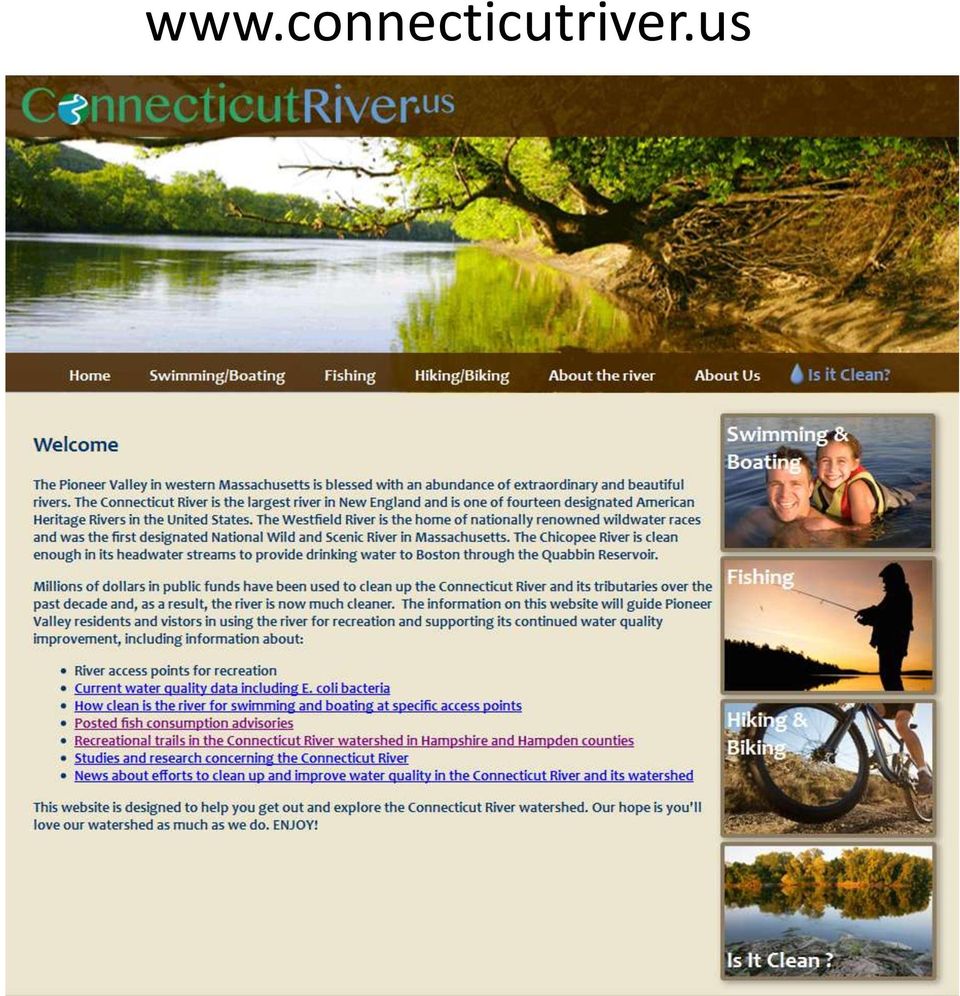
11 System Concept is a one-stop location where public can access and print trail maps and trail information Website currently being constructed Can be accessed at Links to maps and individual trail descriptions Where no trail map currently exists, PVPC is working with trail land owners to create one. GPS trail data is being collected for use in GIS.

12
13 Trail-Specific Web Pages

14 Features of Connecticutriver.us Website Website has information about a variety of outdoor recreational activities, including swimming, boating, fishing, hiking, and biking. Regional trails map currently accessible for download Individual trails will be searchable through an interactive regional map, as well as through pull down menu Menu links to specific trails, either through hotlinks to websites or pdf maps Other information on individual trails to include parking, directions to trailheads, and a description of each trail.

15 Website Development and Use of Drupal Web development was completed by contractor MRW Connected Drupal was specified as the web development platform for the Connecticut River website. This was for the following reasons: Commonly used for web development and is currently outpacing other development platforms (i.e.: Word Press, Joomla, etc.) Drupal is an extremely powerful Content Management System (CMS). It is easy to edit and update for users once site has been launched. Open source software, meaning that it is free to use. Compatible with a wide range of internet browsers Used by virtually every branch of the federal government and many state and municipal agencies

16 Plans for Future Expansion Additional trails in the region to be mapped and included on connecticutriver.us website Update and reprinting of regional trail map Additional funds from future map sales will pay for reprinting

17 Q & A Contact Information Chris Curtis Chief Planner Pioneer Valley Planning Commission [email protected]

NPLOTH7 GIS Database Development Mission (2619), Bryson (2601), Franklin (2603), Dillsboro (2602) Final Report
, Bryson (2601), Franklin (2603), Dillsboro (2602) Final Report") NPLOTH7 GIS Database Development Mission (2619), Bryson (2601), Franklin (2603), Dillsboro (2602) Final Report Introduction Duke Power Nantahala Area (Duke) is in the process of relicensing the Mission,
NPLOTH7 GIS Database Development Mission (2619), Bryson (2601), Franklin (2603), Dillsboro (2602) Final Report Introduction Duke Power Nantahala Area (Duke) is in the process of relicensing the Mission,
Public Survey for Phase I
 Rockfish Valley Area Plan: Public Survey for Phase I For Nelson County Residents & Property Owners Name: OPTIONAL: Location of residence or property: o Address: o Voting District: North Central West South
PUBLIC INFORMATIONAL MEETING THURSDAY APRIL 30, 2015
 PUBLIC INFORMATIONAL MEETING THURSDAY APRIL 30, 2015 AT ACTON TOWN HALL FAULKNER ROOM 472 MAIN STREET ACTON, MASSACHUSETTS 7:00 PM FOR THE PROPOSED ASSABET RIVER RAIL TRAIL (ARRT) IN THE TOWNS OF ACTON
The Nature Conservancy Offering Protected Lands for Sale in the Adirondacks Sustainable Forestry to Continue
 News release For immediate release August 21, 2008 Contact: Connie Prickett, (518) 576-2082 x162, [email protected] The Nature Conservancy Offering Protected Lands for Sale in the Adirondacks Sustainable
Appendix A. Lists of Accomplishments and Project Costs. UMRWD 10 Year Plan Update. Appendix A UPPER MINNESOTA RIVER WATERSHED DISTRICT
 UPPER MINNESOTA RIVER WATERSHED DISTRICT Lists of Accomplishments and Project Costs 10 Year Plan Update UMRWD 10 Year Plan Update Page A 1 UMRWD LIST OF ACCOMPLISHMENTS Since its inception in 1967, the
A. PAVEMENT MANAGEMENT SYSTEM
 CHAPTER 9 PAVEMENT A. PAVEMENT MANAGEMENT SYSTEM A Pavement Management System (PMS) is a systematic process that collects and analyzes roadway pavement information for use in selecting cost-effective strategies
Healthcare Facilities - Pioneer Valley
 Healthcare Facilities - Pioneer Valley Hospitals Baystate Franklin Medical Center 164 High Street Greenfield, MA (413) 773-0211 Acute care hospital with 93 beds. Founded in 1895. Providence Behavioral
Summary of the Second College Grant Master Plan
 1 Summary of the Second College Grant Master Plan Dartmouth College owns and manages 27,000 acres of woodland in the Northern Forest region of New Hampshire, near Erroll, New Hampshire and the Maine state
Oklahoma Governor s Water Conference
 Oklahoma Governor s Water Conference COL Michael Teague District Commander Tulsa District US Army Corps of Engineers 27 October 2010 US Army Corps of Engineers Tulsa District Over 600 people Arkansas River
CONTENTS ABSTRACT. KEYWORDS:. Forest ownership, forest conversion.
 CONTENTS INTRODUCTION... Page PHYSICAL CHANGES IN COMMERCIAL FOREST AREA... 4 Nearly 1 million acres have been lost since 1945... 4 Road construction was leading cause of forest loss in the two states...
Universal Access Program
 Universal Access Program Access News Page 1 P.O. Box 484 Amherst, MA 01004 413-545-5353 Volume 20, Issue 2 Summer/Fall 2016 DCR Provides Universal Access to the Buzzards Bay Coast Before You Come Pre-Register
Lower Crooked Creek Watershed Conservation Plan EXECUTIVE SUMMARY
 EXECUTIVE SUMMARY Project Background Located in southwestern Pennsylvania, Crooked Creek is a major tributary of the Allegheny River, entering near Ford City in Armstrong County. It is rich in natural
MASSACHUSETTS OUTDOORS 2006
 COMMONWEALTH OF MASSACHUSETTS MASSACHUSETTS OUTDOORS 2006 STATEWIDE COMPREHENSIVE OUTDOOR RECREATION PLAN Deval L. Patrick, Governor Ian A. Bowles, Secretary Executive Office of Energy and Environmental
4. Priority Areas of Conservation
 4. Priority Areas of Conservation A. SIGNIFICANT RESOURCE AREAS This Open Space and Farmland Plan identifies the key issues facing open space and agricultural resources in the Town, highlights the location
National Grasslands Visitor Center Manager (Visitor Information Specialist GS-1001-9/11)
") National Grasslands Visitor Center Manager (Visitor Information Specialist GS-1001-9/11) The National Grasslands Visitor Center Hosted by the Nebraska National Forests & Grasslands Wall, South Dakota The
National Grasslands Visitor Center Manager (Visitor Information Specialist GS-1001-9/11) The National Grasslands Visitor Center Hosted by the Nebraska National Forests & Grasslands Wall, South Dakota The
Assistant Superintendent for Recreation
 Assistant Superintendent for Recreation fast facts 1883 Year MPRB established 15.4 million 5 million 182 6,732 200,000 50 27 6 215 60 2 12 12 6 4 345 438 7 59 51 51 6 12 2 7 3 1 2 47 396 Estimated regional
MEMORANDUM OF UNDERSTANDING
 MEMORANDUM OF UNDERSTANDING DEPARTMENT OF HEALTH AND HUMAN SERVICES Centers for Disease Control and Prevention Indian Health Service Office of Public Health and Science And DEPARTMENT OF AGRICULTURE Food
APPENDIX B: TRAIL DEVELOPMENT AND MANAGEMENT STANDARDS
 APPENDIX B: TRAIL DEVELOPMENT AND MANAGEMENT STANDARDS This section provides guidance on a variety of trail issues for planners and developers of the Ice Age NST across the state. It also provides introductory
U.S. Fish and Wildlife Service CHARLES M. RUSSELL NWR Outreach Notice
 U.S. Fish and Wildlife Service CHARLES M. RUSSELL NWR Outreach Notice Supervisory Range Technician (Fire) GS-0455-06/07 Firefighter Location JORDAN, MONTANA The U.S. Fish & Wildlife Region 6 Charles M.
Capital Budget and Debt
 FY 2013 Budget Recommendation Capital Budget and Debt Deval L. Patrick, Governor Timothy P. Murray, Lt. Governor Capital Budget and Debt Capital Investment Plan...5-149 FY 2013 Budget Recommendation Capital
Goals, Strategies, and Tasks
 Goals, Strategies, and Tasks Goals are the broadest expressions of a community's desires. Goals give direction to the plan as a whole. Goals are concerned with the long term, and often describe ideal situations
Carson River Mercury Superfund Site Management Strategies and Goals. May 2011
 Carson River Mercury Superfund Site Management Strategies and Goals May 2011 Staff at NDEP Responsible for CRMS Jeff Collins - Supervisor Over 21 years experience as environmental consultant working on
Produced by: Conservation Trust for North Carolina on behalf of. with funding from WalMart
 Produced by: Conservation Trust for North Carolina on behalf of with funding from WalMart 4th Edition 2010 by the Conservation Trust for North Carolina and N.C. Coastal Land Trust 4th Edition Credits:
USE OF GIS AS A REAL TIME DECISION SUPPORT SYSTEM FOR IRRIGATION DISTRICTS. Gabriele Bonaiti, Ph.D. 1 Guy Fipps, Ph.D., P.E.
 USE OF GIS AS A REAL TIME DECISION SUPPORT SYSTEM FOR IRRIGATION DISTRICTS Gabriele Bonaiti, Ph.D. 1 Guy Fipps, Ph.D., P.E. 2 ABSTRACT GIS technology has been utilized in the past years by drainage and
www.trafficsigns.co.za
 Freeway Advance Exit Advance Turn Final Turn Service Exit Sequence Rest and Service Sequence Advance Roadside Emergency Service Part-Time Attraction National Park (RSA) National Park (Nam) Generic National
Freshwater Fishing E-Licensing System Frequently Asked Questions for Anglers
 Ministry of Environment, Government of British Columbia Freshwater Fishing E-Licensing System Frequently Asked Questions for Anglers These Frequently Asked Questions are intended for anglers who wish to
MAPPING MINNEAPOLIS URBAN TREE CANOPY. Why is Tree Canopy Important? Project Background. Mapping Minneapolis Urban Tree Canopy.
 MAPPING MINNEAPOLIS URBAN TREE CANOPY Why is Tree Canopy Important? Trees are an important component of urban environments. In addition to their aesthetic value, trees have significant economic and environmental
WETLAND REPLICATION IN MASSACHUSETTS
 MACC FALL CONFERENCE 2015 Wetland Replication and Restoration: Let s Get it Right! CONFERENCE AGENDA and SPEAKER BIOS 8:30 A.M. Registration opens and continental breakfast 9:00 A.M. Welcome and Introductions
Using Aerial Photography to Measure Habitat Changes. Method
 Then and Now Using Aerial Photography to Measure Habitat Changes Method Subject Areas: environmental education, science, social studies Conceptual Framework Topic References: HIIIB, HIIIB1, HIIIB2, HIIIB3,
City of Arnold, Missouri
 City of Arnold, Missouri Business Brochure City of Arnold 2101 Jeffco Blvd. Arnold, MO 63010 Phone: 636-282-2378 Fax: 636-282-6677 E-mail: [email protected] The City of Arnold is a suburban community
Utah State General Records Retention Schedule SCHEDULE 1 GEOSPATIAL DATA SETS
 Utah State General Records Retention Schedule SCHEDULE 1 BIOTA RECORDS (Item 1-26) These are geospatial records that depict wildlife use areas in the state of Utah as determined by wildlife biologists
Arkansas River Corridor Vision & Master Plan
 A r k a n s a s R I v e r C o r r I d o r P l a n Arkansas River Corridor Vision & Master Plan July 2005 Indian Nations Council of Governments A r k a n s a s R I v e r C o r r I d o r P l a n Partnership
2012 Project Summary NORTHEAST RECREATIONAL BOATER SURVEY
 2012 Project Summary NORTHEAST RECREATIONAL BOATER SURVEY image courtesy of Urban Harbors Institute of UMass Boston A partnership among industry, government, and nongovernmental organizations conducted
Conservation Easements. Preserving your land for future generations SM
 Conservation Easements Preserving your land for future generations SM The attorneys at Isaacson Rosenbaum are the pioneers of conservation law & conservation easements in the Rocky Mountain region. Their
Land Protection Planning for the National Wildlife Refuge System
 March 2012 Planning Information Brochure 1 Land Protection Planning for the National Wildlife Refuge System The following questions are often asked when the U.S. Fish and Wildlife Service (Service) begins
Highland Charter Township Recreation Plan. Oakland County Parks
 Highland Charter Township Recreation Plan Oakland County Parks Highland Oaks With 264 acres of parkland, Highland Oaks is located within the headwaters of the Shiawassee River and preserves sensitive habitat
Fishing, Hunting & Gathering The Rights and Responsibilities of First Nations People in Manitoba
 Fishing, Hunting & Gathering The Rights and Responsibilities of First Nations People in Manitoba First Nations people have always had a special relationship with the natural life forms that the land provides
One Major Six Concentrations. Department of Environmental Conservation University of Massachusetts Amherst
 One Major Six Concentrations Natural Resources Conservation Undergraduate Major Department of Environmental Conservation University of Massachusetts Amherst Conserving Earth s biological diversity and
Guide to Boulder Neighborhoods
 Guide to Boulder Neighborhoods Presented by Kearney Realty Co. City of Boulder: Overview Population - 102,800 Area - 25 square miles Founded - 1858 Altitude - 5,430 feet Major Industries - University of
LEAGUE NOTES ON APPROVED COMMUNITY WATER SUPPLY PLAN
 1 AUGUST 2011 LEAGUE NOTES ON APPROVED COMMUNITY WATER SUPPLY PLAN KEY ELEMENTS OF THE PLAN: 1. Replace the existing unsafe Ragged Mountain dam with a new dam and raise the reservoir pool level initially
PROMOTING NEW ZEALAND S PREMIUM CYCLE TOURISM EXPERIENCES TO THE WORLD
 Nga Haerenga, The New Zealand Cycle Trail Product Directory Prospectus 2012/2013 Photo: Hawke s Bay Trails PROMOTING NEW ZEALAND S PREMIUM CYCLE TOURISM EXPERIENCES TO THE WORLD Photo: Hawke s Bay Trails
Integration of Forestry & Wildlife Management
 Integration of Forestry & Wildlife Management By Ken Negray Regional Certification Manager, NewPage Corp & member of the KY SIC Committee Abstract: Kentucky SIC (Sustainable Forestry Initiative Implementation
Chapter 3. Alternatives
 Chapter 3. Alternatives 3.1 Introduction Alternatives are different approaches designed to achieve the refuge purpose(s), vision, and the goals identified in the CCP while helping to fulfill the System
Revising the Nantahala and Pisgah Land Management Plan Preliminary Need to Change the Existing Land Management Plan
 Revising the Nantahala and Pisgah Land Management Plan Preliminary Need to Change the Existing Land Management Plan Throughout the Plan 1. There is a fundamental need for the revised plan to address how
MEMORANDUM OF AGREEMENT Between THE CITY OF BALTIMORE And THE MID-ATLANTIC FEDERAL PARTNERSHIP FOR THE ENVIRONMENT
 MEMORANDUM OF AGREEMENT Between THE CITY OF BALTIMORE And THE MID-ATLANTIC FEDERAL PARTNERSHIP FOR THE ENVIRONMENT The Mid-Atlantic Federal Partnership for the Environment ( MAFPE ) and the City of Baltimore
March 2011 DRAFT. I. Working Forest Easements:
 March 2011 DRAFT Minnesota Department of Natural Resources (DNR) Division of Forestry Federal Forest Legacy Program and Minnesota Forests for the Future Program Conservation Easement Stewardship and Monitoring
AN INITIATIVE TO IMPROVE
 L OW E R C A R M E L R I V E R A N D L AG O O N F L O O D P L A I N R E S TO R AT I O N A N D E N H A N C E M E N T P R O J E C T AN INITIATIVE TO IMPROVE FLOOD PROTECTION RESTORE AND PROTECT RIPARIAN
Associate Superintendent of Special Education/SELPA Director. Contract Year 7/1/15 to 6/30/16 (230 work days)
") 609 South Gold Street Siskiyou County Office of Education Yreka, CA 96097 Providing Educational Leadership, Resources and Services to Districts and Schools to Ensure Learning for All Students POSITION:
609 South Gold Street Siskiyou County Office of Education Yreka, CA 96097 Providing Educational Leadership, Resources and Services to Districts and Schools to Ensure Learning for All Students POSITION:
The Trust for Public Land CREATING PARKS FOR PEOPLE CONNECTING CLEVELAND THROUGH PARKS AND TRAILS
 The Trust for Public Land CREATING PARKS FOR PEOPLE CONNECTING CLEVELAND THROUGH PARKS AND TRAILS Lake Link Trail Corridor Location/Context The Proposed Trail Corridor travels along vacated Road and Railroad
Key programs and relevant studies
 ALASKA DEPARTMENT OF NATURAL RESOURCES Key programs and relevant studies The Alaska Department of Natural Resources manages Alaska's surface and subsurface resources, except for fish and game. This includes
Land Specialties is North Georgia s premier development company for mountain lifestyle communities. Whether you imagine life on the lake, the links,
 Land Specialties is North Georgia s premier development company for mountain lifestyle communities. Whether you imagine life on the lake, the links, or the lofty peaks, we bring your vision into clear
Appendix A: Land Protection Plan
 Appendix A: Land Protection Plan In this appendix A.1 Introduction and Purpose A.2 Project Description A.3 Refuge Purposes A.4 Land Acquisition Policy for Urban Refuges A.5 Status of Resources to be Protected
City of Cheney Website Design & Development
 City of Cheney Website Design & Development Request of Proposal CITY OF CHENEY, WASHINGTON 609 2ND ST CHENEY, WA 99004 Table of Contents Overview 3 Situational Anlaysis... 3 Background.. 3 Vendor Qualifications..
Presented by Jim Smith Operations Manager
 Presented by Jim Smith Operations Manager What is GreenArc? A multi agency, cross regional, cross county strategic landscape initiative which aims: to enhance, protect and conserve the green belt for public
DISTRICT VALUES STATEMENTS, GOALS, ACTION ITEMS, AND ONGOING TASKS FOR 2015 Adopted by the Board of Directors December 10, 2014. Values Statements.
 DISTRICT VALUES STATEMENTS, GOALS, ACTION ITEMS, AND ONGOING TASKS FOR 2015 Adopted by the Board of Directors December 10, 2014 Values Statements. The Board opposes any new transfers of water from the
Welcome to the future of Terwillegar Park a Unique Natural Park
 Welcome to the future of Terwillegar Park a Unique Natural Park 1 Introduction The Terwillegar Park Concept Plan study will develop an overall concept plan, management objectives and development guidelines
Welcome to Hillsborough, New Jersey! Prepared by the Hillsborough Economic & Business Development Commission - Fall 2014
 Welcome to Hillsborough, New Jersey! 1 Hillsborough The Good Life Welcome To Hillsborough! 2 Recognition About Hillsborough Our Growing Community A Focus on Family A Prosperous Community Hillsborough Schools
Using an All lands Framework for Conservation of Ecosystem Services
 Using an All lands Framework for Conservation of Ecosystem Services Robert Deal USDA Forest Service - PNW Research Station, Portland, OR Nikola Smith USDA Forest Service - Pacific Northwest Region, Portland,
Motorcycle & Pedestrian Master Plans in Indianapolis, Indiana
 PROJECT PURPOSE The Warsaw + Winona Lake Bicycle and Pedestrian Master Plan establishes a comprehensive framework for a connected bicycle and pedestrian system that will be used for both recreation and
Appendix J Online Questionnaire
 Appendix J Online Questionnaire In accordance with the Paperwork Reduction Act, this questionnaire was approved by the Office of Management and Budget (OMB). The OMB control number and expiration date
Living Here Life Style: Balancing Big-City Convenience and Small-Town Comfort
 Living Here Life Style: Balancing Big-City Convenience and Small-Town Comfort The provides an exceptional number of residential options. For example, the city of Madison, AL, just west of Cummings Research
A RETURN ON INVESTMENT: THE ECONOMIC VALUE OF COLORADO S CONSERVATION EASEMENTS
 A RETURN ON INVESTMENT: THE ECONOMIC VALUE OF COLORADO S CONSERVATION EASEMENTS EXECUTIVE SUMMARY This report, by Jessica Sargent-Michaud, an economist with The Trust for Public Land, analyzes the State
Forester - Forestry Department An Equal Opportunity Employer
 page 1 of 6 DOUGLAS COUNTY (WI) 1316 N. 14th Street, Suite 301 Superior, WI 54880 http://douglascountywi.org Forester - Forestry Department An Equal Opportunity Employer Online applications can be submitted
HUMAN RESOURCES DIRECTOR
 Announces a Recruitment For HUMAN RESOURCES DIRECTOR For THE CITY OF DES PLAINES, ILLINOIS GovHR USA is pleased to announce the recruitment and selection process for the City of Des Plaines, Illinois next
The North State: Implementing the California Water Action Plan February 24, 2014
 The North State: Implementing the California Water Action Plan February 24, 2014 The North State Water Alliance applauds Governor Brown s California Water Action Plan (Action Plan) and his call for comprehensive
White Mountain Guide Online User Guide
 White Mountain Guide Online User Guide 1.1 Minimum System Requirements page 2 1.2 Account Set-up page 2 2.0 Community Side Features page 4 2.1 View or Post a Trip Report page 4 2.2 View or Post a Trail
NEW JERSEY ENVIRONMENTAL INFRASTRUCTURE TRUST. Financial Assistance Programs for Environmental Infrastructure Facilities
 ENVIRONMENTAL PROTECTION AND NEW JERSEY ENVIRONMENTAL INFRASTRUCTURE TRUST Financial Assistance Programs for Environmental Infrastructure Facilities Proposed Readoption: N.J.A.C. 7:22 Authorized By: Bob