DRAINAGE POLICY CONTENTS
|
|
|
- Simon Jennings
- 8 years ago
- Views:
Transcription
1 CONTENTS Section Page DP- 1.0 STATEMENT OF POLICY Policy Principles Basic Knowledge Planning Technical Issues Flood Insurance Implementation PRINCIPLES Drainage Is a Regional Phenomenon That Does Not Respect the Boundaries Between Government Jurisdictions or Between Properties A Storm Drainage System Is a Subsystem of the Total Urban Water Resource System Every Urban Area Has an Initial (i.e., Minor) and a Major Drainage System, Whether or Not They Are Actually Planned and Designed Runoff Routing Is Primarily a Space Allocation Problem Planning and Design of Stormwater Drainage Systems Generally Should Not Be Based on the Premise That Problems Can Be Transferred From One Location to Another An Urban Storm Drainage Strategy Should Be a Multi-Objective and Multi-Means Effort Design of the Stormwater Drainage System Should Consider the Features and Functions of the Existing Drainage System In New Developments, Attempts Should Be Made to Reduce Stormwater Runoff Rates and Pollutant Load Increases After Development to the Maximum Extent Practicable The Stormwater Management System Should Be Designed Beginning With the Outlet or Point of Outflow From the Project, Giving Full Consideration to Downstream Effects and the Effects of Off-Site Flows Entering the System The Stormwater Management System Should Receive Regular Maintenance Floodplains Need to Be Preserved Whenever Feasible and Practicable Reserve Sufficient Right-of-Way for Lateral Movement of Incised Floodplains BASIC KNOWLEDGE Data Collection Storm Runoff and Flood Damage Rainfall-Runoff Relationships Inventory of Successful Projects Library Runoff Magnitudes Floodplain Data Small Waterways Data Inventory Floodplains Priority for Data Acquisition Data Use /2001 DP-i

2 DRAINAGE CRITERIA MANUAL (V. 1) Master Plan Public Cost Easements PLANNING Total Urban System Development Plan Master Plan Planning Process Ingredients Local and Regional Planning Site Planning Water Quality Multiple-Objective Considerations Lower Drainage Costs Open Space Transportation Natural Channels Channelization Channel Storage Major Runoff Capacity Maintenance and Maintenance Access Transfer of Problems Intra-Watershed Transfer Inter-Watershed Transfer Watershed Planning Detention and Retention Storage Upstream Storage Minimized Directly Connected Impervious Area Development Downstream Storage Reliance on Non-Flood-Control Reservoirs Reliance on Embankments TECHNICAL CRITERIA Design Criteria Design Criteria Criteria Updating Use of Criteria Initial and Major Drainage Design Storm Return Periods Initial Storm Provisions Major Storm Provisions Critical Facilities Major Drainage Channels Tailwater Runoff Computation Accuracy Streets Use of Streets Irrigation Ditches Use of Ditches Ditch Perpetuation Conformance With Master Plan Detention and Retention Facilities Maintenance Water Quality DP-ii 06/2001

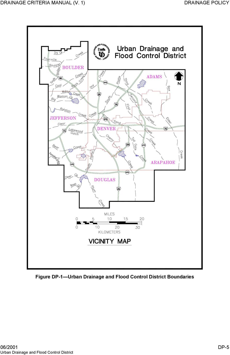
3 6.0 FLOODPLAIN MANAGEMENT Purpose Goals National Flood Insurance Program Participation Floodplain Management Floodplain Filling New Development Strategies and Tools Exposure to Floods Development Policies Preparedness Flood Proofing Flood Forecasting Flood Modification Impact of Modification IMPLEMENTATION Adoption of Drainage Master Plans Manual Potential Governmental Operations Amendments Financing Drainage Costs REFERENCES Tables Table DP-1 Reasonable Use of Streets for Initial Storm Runoff in Terms of Pavement Encroachment Table DP-2 Major Storm Runoff Recommended Maximum Street Inundation Table DP-3 Allowable Maximums for Cross-Street Flow Figures Figure DP-1 Boundaries... 5 Photographs Photograph DP-1 Denver grass-lined channel after 35 years of service. Ann Spirn of the Massachusetts Institute of Technology refers to this channel as "urban poetry" in her publications. Spirn appreciates the soft natural lines... 1 Photograph DP-3 National Medal of Science winner, Dr. Gilbert White, recommends natural-like floodplains because they save people from damages and are good for the economy... 9 Photograph DP-4 Drainageways having slow-flow characteristics, with vegetated bottoms and sides can provide many benefits Photograph DP-5 Detention basins with permanent ponding help in many ways, including flood reduction, water quality and land values /2001 DP-iii

4

5 1.0 STATEMENT OF POLICY 1.1 Policy Adequate drainage for urban areas is necessary to preserve and promote the general health, welfare, and economic well being of the region. Drainage is a regional feature that affects all governmental jurisdictions and all parcels of property. This characteristic of drainage makes it necessary to formulate a program that balances both public and private involvement (Wright-McLaughlin Engineers 1969). Overall, the governmental agencies most directly involved must provide coordination and master planning, but drainage planning must also be integrated on a regional level (FEMA 1995). When planning drainage facilities, certain underlying principles provide direction for the effort. These principles are made operational through a set of policy statements. The application of the policy is, in turn, facilitated by technical drainage criteria and data. When considered in a comprehensive manner on a regional level with public and private involvement drainage facilities can be provided in an urban area in a manner that will avoid uneconomic water losses and disruption, enhance the general health and welfare of the region, and assure optimum economic and social relationships (White 1945). Photograph DP-1 Denver grass-lined channel after 35 years of service. Ann Spirn of the Massachusetts Institute of Technology refers to this channel as "urban poetry" in her publications. Spirn appreciates the soft natural lines. The principles and policies for urban storm drainage are summarized below. 06/2001 DP-1
.")
6 DRAINAGE CRITERIA MANUAL (V. 1) 1.2 Principles Drainage is a regional phenomenon that does not respect the boundaries between government jurisdictions or between properties. A storm drainage system is a subsystem of the total urban water resource system. Every urban area has an initial and a major drainage system, whether or not they are actually planned and designed. Runoff routing is primarily a space allocation problem. Planning and design of stormwater drainage systems generally should not be based on the premise that problems can be transferred from one location to another. An urban storm drainage strategy should be a multi-objective and multi-means effort. Design of the stormwater drainage system should consider the features and functions of the existing drainage system. In new developments, attempts should be made to reduce stormwater runoff rates and pollutant load increases after development to the maximum extent practicable. The stormwater management system should be designed, beginning with the outlet or point of outflow from the project, giving full consideration to downstream effects and the effects of off-site flows entering the system. The stormwater management system should receive regular maintenance. Floodplains need to be preserved whenever feasible and practicable. Reserve sufficient right-of-way to permit lateral channel movement whenever the floodplain is contained within a narrow natural channel. 1.3 Basic Knowledge A program for collecting and analyzing storm runoff and flood data should be maintained in order that intelligent and orderly planning may be undertaken in regard to storm drainage facilities. A program should be maintained to delineate flood hazard areas along all waterways in the region which are urbanized or which may be in the future. This program should make full use of the information and data from the Federal Emergency Management Agency (FEMA), the U.S. Geological Survey (USGS), private consulting engineers, and the Colorado Water Conservation Board. This information should be DP-2 06/2001

7 regularly reviewed and updated to reflect changes due to urbanization, changed channel conditions, and the occurrence of extraordinary hydrologic events. Before commencing design of any drainage project, comprehensive facts and data should be collected and examined for the particular watershed and area under consideration, and the basis for the design should then be agreed upon by the governmental entities affected. 1.4 Planning Storm drainage is a part of the total urban environmental system. Therefore, storm drainage planning and design must be compatible with comprehensive regional plans. A master plan for storm drainage should be developed and maintained in an up-to-date fashion at all times for each urbanizing drainage watershed in the Denver region. The planning for drainage facilities should be coordinated with planning for open space and transportation. By coordinating these efforts, new opportunities may be identified that can assist in the solution of drainage problems. Natural drainageways should be used for storm runoff waterways wherever feasible. Major consideration must be given to the floodplains and open space requirements of the area (White 1945). Planning and design of stormwater drainage systems should not be based on the premise that problems can be transferred from one location to another. Stormwater runoff can be stored in detention and retention reservoirs. Such storage can reduce the drainage conveyance capacity required immediately downstream. Acquisition of open space having a relationship to drainageways will provide areas where storm runoff can spread out and be stored for slower delivery downstream. 1.5 Technical Issues Storm drainage planning and design should follow the criteria developed and presented in this Urban Storm Drainage Criteria Manual (Manual). Every urban area has two separate and distinct drainage systems, whether or not they are actually planned and designed. One is the initial system, and the other is the major system. To provide for orderly urban growth, reduce costs to future generations and avoid loss of life and major property damage, both systems must be planned, properly engineered and maintained. The determination of runoff magnitude should be by the Rational Formula, the Colorado Urban Hydrograph Procedure (CUHP), or statistical analyses based on an adequate record of actual measured flood occurrences as set forth in the RUNOFF chapter of this Manual. Use of streets for urban drainage should fully recognize that the primary use of streets is for traffic. 06/2001 DP-3

8 DRAINAGE CRITERIA MANUAL (V. 1) Streets should not be used as floodways for initial storm runoff. Urban drainage design should have as an objective reduction of street repair and maintenance costs to the public. Irrigation ditches should not be used as outfall points for initial or major drainage systems, unless such use is shown to be without unreasonable hazard, as substantiated by thorough hydraulic engineering analysis, and written approval of the ditch owner(s) is obtained. In addition, irrigation ditches cannot be relied on for mitigating upstream runoff. Proper design and construction of stormwater detention and retention basins are necessary to minimize future maintenance and operating costs and to avoid public nuisances and health hazards. This is particularly important, given the many detention and retention facilities in the Denver region. The various governmental agencies within the Denver region have adopted and need to maintain their floodplain management programs. Floodplain management must encompass comprehensive criteria designed to encourage, where necessary, the adoption of permanent measures which will lessen the exposure of life, property and facilities to flood losses, improve the long-range land management and use of flood-prone areas, and inhibit, to the maximum extent feasible, unplanned and economically unjustifiable future development in such areas. 1.6 Flood Insurance Flood insurance is an integral part of the strategy to manage flood losses. The Denver region should encourage continued participation in the National Flood Insurance Program, set forth in the National Flood Insurance Act (NFIA) of 1968, as amended. 1.7 Implementation This Manual should continue to be adopted by all governmental agencies operating within the region. Each level of government is encouraged to participate in a successful drainage program. Problems in urban drainage administration encountered by any governmental agency can be reviewed by the (District) to determine if equity or public interests indicate a need for drainage policy, practice, or procedural amendments (Figure DP-1). The financing of storm drainage improvements is fundamentally the responsibility of the affected property owners both the persons directly affected by the water and the person from whose land the water flows. DP-4 06/2001
 is obtained. In addition, irrigation ditches cannot be relied on for mitigating upstream runoff.")
9 Figure DP-1 Boundaries 06/2001 DP-5
10 DRAINAGE CRITERIA MANUAL (V. 1) 2.0 PRINCIPLES 2.1 Drainage Is a Regional Phenomenon That Does Not Respect the Boundaries Between Government Jurisdictions or Between Properties This makes it necessary to formulate programs that include both public and private involvement. Overall, the governmental agencies most directly involved must provide coordination and master planning, but drainage planning must be integrated on a regional level if optimum results are to be achieved. The ways in which proposed drainage systems fit existing regional systems must be quantified and discussed in the master plan. 2.2 A Storm Drainage System Is a Subsystem of the Total Urban Water Resource System Stormwater system planning and design for any site must be compatible with comprehensive regional plans and should be coordinated, particularly with planning for land use, open space and transportation. Erosion and sediment control, flood control, site grading criteria, and regional water quality all closely interrelate with urban stormwater management. Any individual master plan or specific site plan should normally address all of these considerations. 2.3 Every Urban Area Has an Initial (i.e., Minor) and a Major Drainage System, Whether or Not They Are Actually Planned and Designed The initial drainage system, sometimes referred to as a minor system, is designed to provide public convenience and to accommodate moderate, frequently occurring flows. The major system carries more water and operates when the rate or volume of runoff exceeds the capacity of the minor system. Both systems should be carefully considered. 2.4 Runoff Routing Is Primarily a Space Allocation Problem The volume of water present at a given point in time in an urban region cannot be compressed or diminished. Channels and storm sewers serve both conveyance and storage functions. If adequate provision is not made for drainage space demands, stormwater runoff will conflict with other land uses, will result in damages, and will impair or even disrupt the functioning of other urban systems. 2.5 Planning and Design of Stormwater Drainage Systems Generally Should Not Be Based on the Premise That Problems Can Be Transferred From One Location to Another Urbanization tends to increase downstream peak flow by increasing runoff volumes and the speed of runoff. Stormwater runoff can be stored in detention facilities, which can reduce the drainage capacity required immediately downstream. DP-6 06/2001

11 2.6 An Urban Storm Drainage Strategy Should Be a Multi-Objective and Multi-Means Effort The many competing demands placed upon space and resources within an urban region argue for a drainage management strategy that meets a number of objectives, including water quality enhancement, groundwater recharge, recreation, wildlife habitat, wetland creation, protection of landmarks/amenities, control of erosion and sediment deposition, and creation of open spaces. Photograph DP-2 An urban storm drainage strategy should be a multi-objective and multi-means effort. 2.7 Design of the Stormwater Drainage System Should Consider the Features and Functions of the Existing Drainage System Every site contains natural features that may contribute to the management of stormwater without significant modifications. Existing features such as natural drainageways, depressions, wetlands, floodplains, permeable soils, and vegetation provide for infiltration, help control the velocity of runoff, extend the time of concentration, filter sediments and other pollutants, and recycle nutrients. Each development plan should carefully map and identify the existing natural system. Techniques that preserve or protect and enhance the natural features are encouraged. Good designs improve the effectiveness of natural systems rather than negate, replace or ignore them. 2.8 In New Developments, Attempts Should Be Made to Reduce Stormwater Runoff Rates and Pollutant Load Increases After Development to the Maximum Extent Practicable 1. The perviousness of the site should be maintained, to the extent feasible. 06/2001 DP-7

12 DRAINAGE CRITERIA MANUAL (V. 1) 2. The rate of runoff should be slowed. Preference should be given to stormwater management systems that use practices that maximize vegetative and porous land cover. These systems will promote infiltration, filtering and slowing of the runoff. It should be noted that, due to the principle of mass conservation, it is virtually impossible to prevent increases in post-development runoff volumes when an area urbanizes. However, existing stormwater regulations can require control of peak flows to predevelopment levels to a maximum extent achievable. Increased flow volumes may present no flooding problems if the watershed has a positive outfall to a stream or river; however, these volumes may cause problems for a small, enclosed watershed draining to a lake or into streams of limited capacity. 3. Pollution control is best accomplished by implementing a series of measures, which can include source control, minimization of directly connected impervious areas, and construction of on-site and regional facilities, to control both runoff and pollution. 2.9 The Stormwater Management System Should Be Designed Beginning With the Outlet or Point of Outflow From the Project, Giving Full Consideration to Downstream Effects and the Effects of Off-Site Flows Entering the System The downstream conveyance system should be evaluated to ensure that it has sufficient capacity to accept design discharges without adverse backwater or downstream impacts such as flooding, stream bank erosion, and sediment deposition. In addition, the design of a drainage system should take into account the runoff from upstream sites, recognizing their urban development potential The Stormwater Management System Should Receive Regular Maintenance Failure to provide proper maintenance reduces both the hydraulic capacity and pollutant removal efficiency of the system. The key to effective maintenance is clear assignment of responsibilities to an established agency and a regular schedule of inspections to determine maintenance needs and to ensure that required maintenance is done. Local maintenance capabilities should be a consideration when selecting specific design criteria for a given site or project Floodplains Need to Be Preserved Whenever Feasible and Practicable Nature has claimed a prescriptive easement for floods, via its floodplains, that cannot be denied without public and private cost. Floodplains often provide a natural order to the land surface with drainageways that serve as outfalls for urban drainage, bottomland for wildlife habitat, riparian corridors, and specialized vegetation. Floodplain encroachment can occur only after competent engineering and planning have been conducted to assure that flow capacity is maintained, risks of flooding are defined and risks to life and property are strictly minimized. Preservation of floodplains is a policy of the District to manage flood DP-8 06/2001

13 hazards, preserve habitat and open space, create a more livable urban environment, and protect the public health, safety, and welfare (White 1945). Photograph DP-3 National Medal of Science winner, Dr. Gilbert White, recommends natural-like floodplains because they save people from damages and are good for the economy Reserve Sufficient Right-of-Way for Lateral Movement of Incised Floodplains Whenever a floodplain is contained within a narrow (i.e., degraded) channel, its lateral movement over time can cause extensive damages to public and private structures and facilities. For this reason, whenever such a condition exists, it is recommended that, at a minimum, the channel be provided with grade control structures and a right-of-way corridor be preserved of a width equivalent to the cross section recommended for a grass-lined channel, including a maintenance access roadway. 06/2001 DP-9

14 DRAINAGE CRITERIA MANUAL (V. 1) 3.0 BASIC KNOWLEDGE 3.1 Data Collection An important step in a drainage program is to get the facts. A program for collecting and analyzing storm runoff and flood data should be maintained to promote intelligent and orderly planning (Jones 1967) Storm Runoff and Flood Damage Storm runoff and flood damage data should be collected in a systematic and uniform manner Rainfall-Runoff Relationships A program should be maintained to collect and analyze rainfall-runoff relationships in urban areas of the Denver region Inventory of Successful Projects Some drainage projects function better than others. It is important to determine why, so that key features may be inventoried for use on other succeeding projects Library The District should acquire and actively maintain a library, which should be available for use by all governmental agencies, practicing planners, and engineers. The public should be encouraged to use the library as part of the District s educational and outreach programs Runoff Magnitudes Where practical, the magnitude of computed and measured runoff peaks should be tabulated for Denver region streams and gulches so that comparisons may be readily made between watersheds and erroneous values may be more easily identified. 3.2 Floodplain Data The program to delineate flood hazard areas along all waterways in the region should be maintained. This program should make full use such sources as the District's Flood Hazard Area Delineation studies, the FEMA Flood Insurance Studies, data from the Natural Resources Conservation Service, the USGS, and floodplain studies by private consulting engineers. This information should be regularly reviewed and updated to reflect changes due to urbanization, changed channel conditions, and the occurrence of extraordinary hydrologic events Small Waterways Small gulches and other waterways, which are often overlooked, have a large damage potential. These waterways should receive early attention in areas subject to urbanization. Floodplain information should be shown on preliminary and final subdivision plats, including the areas inundated by major storm runoff and areas of potential erosion. DP-10 06/2001

15 3.2.2 Data Inventory The information collected should be stored in a central District depository available to all planners, developers, and engineers Floodplains This effort should be aimed towards developing information on those areas that have a one percent chance of being inundated in any given year that is, the 100-year floodplain. Local governmental agencies may choose to regulate floodplains for other frequencies of flooding; however, the 100-year floodplain based on runoff from the projected fully urbanized watershed must be defined in addition to being the minimum basis for regulation Priority for Data Acquisition The District will establish priorities for acquisition of data because it is recognized that not all of the data can be collected at one time. When setting priorities, consideration should be given to: a. Areas of rapid urban growth b. Drainage problem areas c. Local interest and capabilities in floodplain management d. Potential for developing significant information 3.3 Data Use Prior to the commencement of any drainage project, comprehensive facts and data should be collected and examined for the particular watershed and area under consideration Master Plan Drainage design does not lend itself to a piece-meal approach; therefore, master plans for drainage should be prepared on a priority basis. Such plans already cover most of the developed major drainageways in the District. Additional plans will be developed for areas yet unplanned. In addition, existing master plans will be updated as needed to reflect changed conditions that take place over time Public Cost Development of an area without the provision of adequate drainage multiplies the cost to the public because the drainage problem must be corrected later, usually at public expense Easements Where construction occurs along a waterway not yet developed downstream or upstream, and where a master plan is not yet available, flood easements should be left which will include the future development 100-year floodplain. Where an existing master plan recommends the preservation of a defined floodplain, 06/2001 DP-11

16 DRAINAGE CRITERIA MANUAL (V. 1) every effort should be made to acquire and/or preserve an easement or property right (ownership) for such a floodplain. On any floodplain, nature possesses by prescription an easement for intermittent occupancy by runoff waters. Man can deny this easement only with difficulty. Encroachments upon or unwise land modifications within this easement can adversely affect upstream and downstream flooding occurrences during the inevitable periods of nature s easement occupancy. Floodplain regulation, then, must define natural easements and boundaries and must delineate floodplain occupancy that will be consistent with total public interests. DP-12 06/2001

17 4.0 PLANNING 4.1 Total Urban System Storm drainage is a part of the total urban environmental system. Therefore, storm drainage planning and design should be compatible with comprehensive regional plans. Master plans for storm drainage have been developed and maintained in an up-to-date fashion for most of the watersheds in the Denver region. An effort to complete the coverage of master plans for yet unplanned areas of the District should be continued until full coverage is achieved Development Plan A development plan should be given direction by broad, general framework goals. Examples of such goals are: 1. Drainage and flood control problem alleviation 2. Economic efficiency 3. Regional development 4. Environmental preservation and enhancement 5. Social and recreational need fulfillment These goals, or combinations of these goals, as they are pursued within an urban region, have the potential to influence greatly the type of drainage subsystem selected. Planning for drainage facilities should be related to the goals of the urban region, should be looked upon as a subsystem of the total urban system, and should not proceed independent of these considerations (Wright 1967) Master Plan Each municipality and county in the Denver region is responsible for master planning for urban storm drainage facilities within its boundaries and environs. The District can help to coordinate efforts. Cooperation between governmental agencies is needed to solve drainage problems and joint city, county and District efforts are encouraged. Carrying forward master planning is best accomplished on a priorityphased basis so that the most demanding problems, such as areas of rapid urbanization, may be addressed at an early date. Early work includes the planning of major drainageways from the point of outfall, proceeding in an upstream direction. The major drainageways are generally well defined and often dictate the design of the initial drainage system, including storm sewers, detention facilities, and water quality systems. The District has established a suitable format for master plan reports and drawings so that a uniform planning approach and coordination of efforts can more easily be made. Master planning should be done 06/2001 DP-13

18 DRAINAGE CRITERIA MANUAL (V. 1) in enough detail and with adequate thoroughness to provide a ready drainage development guide for the future in a particular watershed. Generalized concepts based on rule-of-thumb hydrological analyses should not be used as master plans; a more rigorous analysis is necessary Planning Process Ingredients Good urban drainage planning is a complex process. Fundamentals include: 1. Major Drainage Planning. All local and regional planning must take into consideration the major drainage system necessary to manage the runoff that is expected to occur once every 100 years. The major drainage system plans will reduce loss of life and major damage to the community and its infrastructure. 2. Initial Drainage System Planning. All local and regional planning must take into consideration the initial drainage system to transport the runoff from storms expected to occur once every 2 to 10 years. The planner of an initial system must strive to minimize future drainage complaints. 3. Environmental Design. Environmental design teams involving a range of disciplines should be convened whenever desirable to ensure that the benefits to total urban systems receive consideration in the drainage planning work. Planning should address water quality enhancements and include evaluation of the impacts of new facilities, as well as future operation and maintenance by private and public bodies Local and Regional Planning Local and regional planning, whether performed under federal or state assistance programs or under completely local auspices, should consider and evaluate opportunities for multi-objective water resources management Site Planning All land development proposals should receive full site planning and engineering analyses. In this regard, professional consideration must be given to the criteria outlined in the Manual. Where flood hazards are involved, the local planning boards should take into consideration proposed land use so that it is compatible with the flood hazard risks involved with the property, and appropriate easements need to be provided to preclude encroachment upon waterways or flood storage areas Water Quality Protecting and enhancing the water quality of public streams is an important objective of drainage planning. Erosion control, maintaining stream channel stability, sediment and debris collection, and pollutant removal from stormwater runoff must be taken into account by using the stormwater runoff best management practices (BMPs) described in Volume 3 of this Manual. Sanitary sewerage systems that overflow or bypass untreated sewage into surface streams should not be DP-14 06/2001

19 permitted in the Denver region. Existing systems that discharge sewage should be adjusted by their owners to eliminate this problem. Full cooperation should be extended to planners and designers of sanitary sewerage works to minimize the hazards involved with the flooding of sanitary sewers by urban storm runoff. Drainage planning should include means to prevent inflow to sanitary sewers because of street flow and flooding of channels. 4.2 Multiple-Objective Considerations Planning for drainage facilities should be coordinated with planning for open space, recreation and transportation. By coordinating these efforts, new opportunities can be identified which can assist in the solution of drainage problems (Heaney, Pitt and Field 1999) Lower Drainage Costs Planning drainage works in conjunction with other urban needs results in more orderly development and lower costs for drainage and other facilities Open Space Open space provides significant urban social benefits. Use of stabilized, natural drainageways often is less costly than constructing artificial channels. Combining the open space needs of a community with major drainageways is a desirable combination of uses that reduces land costs and promotes riparian zone protection and establishment over time Transportation Design and construction of new streets and highways should be fully integrated with drainage needs of the urban area for better streets and highways and better drainages and to avoid creation of flooding hazards. The location of borrow pits needed for road construction should be integrated with broad planning objectives, including storm runoff detention. 4.3 Natural Channels Natural drainageways should be used for storm runoff waterways wherever practical. Preservation and protection of natural drainageways are encouraged; however, major consideration must be given to their stability as the area urbanizes Channelization Natural drainageways within an urbanizing area are often deepened, straightened, lined, and sometimes put underground. A community loses a natural asset when this happens. Channelizing a natural waterway usually speeds up the flow, causing greater downstream flood peaks and higher drainage costs, and does nothing to enhance the environment. 06/2001 DP-15

20 DRAINAGE CRITERIA MANUAL (V. 1) Channel Storage Drainageways having slow-flow characteristics, vegetated bottoms and sides, and wide water surfaces provide significant floodplain storage capacity. This storage is beneficial in that it reduces downstream runoff peaks and provides an opportunity for groundwater recharge. Wetland channels, wide natural channels, and adjacent floodplains provide urban open space. Photograph DP-4 Drainageways having slow-flow characteristics, with vegetated bottoms and sides can provide many benefits Major Runoff Capacity Drainageways and their residual floodplains should be capable of carrying the major storm runoff, which can be expected to have a one percent chance of occurring in any single year Maintenance and Maintenance Access Waterways will require both scheduled and unscheduled maintenance for a wide array of activities such as sediment, debris and trash removal, mowing, and repair of hydraulic structures. Assured long term maintenance is essential, and it must be addressed during planning and design. The District assists with drainage facility maintenance, provided that the facilities are designed in accordance with the District s Maintenance Eligibility Guidelines. The June 2001 version of these guidelines are available on the CD version of this Manual, and updates to these guidelines should be obtained from the District s Web site at Designers are strongly encouraged to adhere to the design criteria listed in the Maintenance Eligibility Guidelines. Waterways, detention structures and other facilities must have permanent access for routine and major maintenance activities. DP-16 06/2001

21 4.4 Transfer of Problems Planning and design of stormwater drainage systems should not be based on the premise that problems can be transferred from one location to another Intra-Watershed Transfer Channel modifications that create unnecessary problems downstream should be avoided, both for the benefit of the public and to avoid damage to private parties. Problems to avoid include land and channel erosion and downstream sediment deposition, increase of runoff peaks, and debris transport, among others Inter-Watershed Transfer Diversion of storm runoff from one watershed to another introduces significant legal and social problems and should be avoided unless specific and prudent reasons justify and dictate such a transfer and no measurable damages occur to the natural receiving water or urban systems or to the public Watershed Planning Master planning must be based upon potential future upstream development, taking into consideration both upstream and downstream existing and future regional publicly owned and operated detention and retention storage facilities. Such facilities must be assured of construction, perpetual operation and maintenance. Urban development causes a major increase in the volume of runoff, even though the peak flows for certain return floods might be managed to simulate those of undeveloped historic conditions. In the absence of such detention and retention facilities, the basis of design for both the initial and major systems is fully developed upstream conditions without storage. 4.5 Detention and Retention Storage Stormwater runoff can be stored in detention and retention reservoirs. Such storage can reduce the peak flow drainage capacity required, thereby reducing the land area and expenditures required downstream. (However, see limitation in regarding taking credit for detention.) In some instances of stormwater retention and detention, there may be water rights implications, and in those instances, the State Engineer s Office should be consulted Upstream Storage Storage of storm runoff close to the points of rainfall occurrence includes use of parking lots, ball fields, property line swales, parks, road embankments, borrow pits, and on-site basins and ponds. Large parking lots, like those at shopping centers, create more runoff volume than before with high runoff discharge rates. The same is true for many small parking lots. Parking lots should be designed to provide for storage of runoff during infrequent events except where clearly shown that such storage is impractical. Wherever reasonably acceptable from a social standpoint, parks should be used for short- 06/2001 DP-17
22 DRAINAGE CRITERIA MANUAL (V. 1) term detention of storm runoff to create drainage benefits. Such use may help justify park and greenbelt acquisition and expenditures. The difficulty in quantifying the cumulative effects of very large numbers of small (i.e., on-site) detention/retention facilities (Malcomb 1982; Urbonas and Glidden 1983) and the virtual impossibility of assurance of their continued long-term performance or existence (Debo 1982; Prommersberger 1984) requires the District to recognize in its floodplain management only regional, publicly owned facilities. Nevertheless, upstream storage is encouraged, such as with the "Blue-Green" concept first described in Civil Engineering magazine (Jones 1967) Minimized Directly Connected Impervious Area Development The minimized directly connected impervious area (MDCIA) concept (refer to Volume 3 of this Manual) provides an approach to upstream stormwater management that reduces the amount of impervious surfaces in a development and their connection to the initial drainage system. In addition, it includes functional grading, wide and shallow surface flow sections, disconnection of hydrologic flow paths, and the use of porous landscape detention and porous pavement areas. Details for its use are presented in Volume 3 of this Manual. The technique of MDCIA is also referred to as low impact development (LID). Other references include Heaney, Pitt and Field (1999) and Prince George s County, Maryland (1999) Downstream Storage The detention and retention of storm runoff is desirable in slow-flow channels, in storage reservoirs located in the channels, in off-stream reservoirs, and by using planned channel overflow ponding in park and greenbelt areas. Lengthening the time of concentration of storm runoff to a downstream point is an important goal of storm drainage and flood control strategies. This should be achieved via numerous and varied techniques Reliance on Non-Flood-Control Reservoirs Privately owned non-flood-control reservoirs cannot be used for flood mitigation purposes in master planning because their perpetuity cannot be reasonably guaranteed. Publicly owned water storage reservoirs (city, state, water district, irrigation company, etc.) should be assumed to be full for flood planning purposes and, therefore, only the detention storage above the spillway crest can be utilized in regard to the determination of downstream flood peak flows Reliance on Embankments The detention of floodwaters behind embankments created by railroads, highways or roadways resulting from hydraulically undersized culverts or bridges should not be utilized by the drainage engineer for flood peak mitigation when determining the downstream flood peaks for channel capacity purposes unless such detention has been covered by a binding agreement approved by the District. DP-18 06/2001
23 5.0 TECHNICAL CRITERIA 5.1 Design Criteria Storm drainage planning and design should adhere to the criteria developed and presented in this Manual maintained by the District Design Criteria The design criteria presented herein represent current good engineering practice, and their use in the Denver region is recommended. The criteria are not intended to be an ironclad set of rules that the planner and designer must follow; they are intended to establish guidelines, standards and methods for sound planning and design Criteria Updating The criteria contained in this Manual should be revised and updated as necessary to reflect advances in the field of urban drainage engineering and urban water resources management Use of Criteria Governmental agencies and engineers should utilize this Manual in planning new facilities and in their reviews of proposed works by developers, private parties, and other governmental agencies, including the Colorado Department of Transportation and other elements of the state and federal governments. 5.2 Initial and Major Drainage Every urban area has two separate and distinct drainage systems, whether or not they are actually planned and designed. One is the initial system, and the other is the major system. To provide for orderly urban growth, reduce costs to future generations, and avoid loss of life and major property damage, both systems must be planned and properly engineered Design Storm Return Periods Storm drainage planning and design should fully recognize the need for considering two separate and distinct storm drainage systems: the initial drainage system and the major drainage system. Local governments should not be tempted to specify larger than necessary design runoff criteria for the initial drainage system because of the direct impact on the cost of urban infrastructure. There are many developed areas within the Denver urban region that do not fully conform to the drainage standards projected in this Manual. The multitude of problems associated with these areas historically provided the emphasis required to proceed with development of this Manual. It is recognized that upgrading these developed areas to conform to all of the policies, criteria, and standards contained in this Manual will be difficult, if not impractical, to obtain, short of complete redevelopment or renewal. However, flood-proofing techniques can be applied to these areas. 06/2001 DP-19
24 DRAINAGE CRITERIA MANUAL (V. 1) Strict application of this Manual in the overall planning of new development is practical and economical; however, when planning drainage improvements and the designation of floodplains for developed areas, the use of the policies, criteria, and standards contained in this Manual should be adjusted to provide for economical and environmentally sound solutions consistent with other goals of the area. Where the 100- year storm is not chosen for design purposes, the impact of the 100-year storm should be investigated and made known Initial Storm Provisions The initial storm drainage system, capable of safely handling 2- to 10-year floods depending on local criteria, is necessary to reduce the frequency of street flooding and maintenance costs, to provide protection against regularly recurring damage from storm runoff, to help create an orderly urban system, and to provide convenience to urban residents. Normally, the initial drainage system cannot economically carry major runoffs, though the major drainage system can provide for the initial runoff. A well-planned major drainage system will reduce or eliminate the need for storm sewer systems (Jones 1967). Storm sewer systems consisting of underground pipes are a part of initial storm drainage systems Major Storm Provisions In addition to providing the storm drainage facilities for the initial storm runoff, provisions should be made to avoid major property damage and loss of life for the storm runoff expected to occur from an urbanized watershed once every 100 years on average (i.e., one percent probability of occurrence any given year). Such provisions are known as the major drainage system Critical Facilities Drainage engineers and planners should consider that certain critical facilities may need a higher level of flood protection. For instance, hospitals, police, fire stations and emergency communication centers should be designed in a manner so that, even during a 100-year flood, their functioning will not be compromised. The use of a 500-year flood level for such facilities may be justified in many instances Major Drainage Channels Open channels for transporting major storm runoff are more desirable than closed sewers in urban areas, and use of such channels is encouraged. Open channel planning and design objectives are often best met by using natural-type vegetated channels, which characteristically have slower velocities and large width-to-depth ratios. Additional benefits from open channels can be obtained by incorporating parks and greenbelts with the channel layout. When evaluating existing natural water courses (perennial, intermittent and ephemeral), it is desirable to minimize straightening, fill placement, and other alterations. Alterations such as these should be very carefully evaluated. Normally, however, some structural stabilization will be necessary to address the increased effects on stream stability caused by increased flows due to urbanization. For example, grade control structures and structural protection at the channel toe and on outer banks are normally required. DP-20 06/2001
25 The filling, straightening or altering of natural water courses, perhaps wet only during and after large rainstorms, is discouraged. Such actions tend to reduce flood storage and increase the velocity to the detriment of those downstream of and adjacent to the channel work. Effort must be made to reduce flood peaks and control erosion so that the natural channel regime is preserved as much as practical. Buffer zones can be used to account for future channel meandering and bank sloughing, at least in part. Use of open channels should receive early attention when planning a new development, along with other storm runoff features Tailwater The depth of flow in the receiving stream must be taken into consideration for backwater computations for either the initial or major storm runoff. 5.3 Runoff Computation The determination of runoff magnitude should be made using the techniques described in the RUNOFF chapter of this Manual Accuracy The peak discharges determined by any method are approximations. Rarely will drainage works operate at the design discharge. Flow will always be more or less in actual practice as it rises and falls during a storm event. Thus, the engineer should not overemphasize the detailed accuracy of computed discharges but should emphasize the design of practical and hydraulically balanced works based on sound logic and engineering, as well as dependable hydrology. The use of more than three significant figures for estimating the flood magnitudes conveys a false sense of accuracy and should be avoided. Because of the public s reliance on published peak flow estimates, they should only be changed when it is clear that an original error has been made and that continuing their use would not be in the public s interest. 5.4 Streets Use of Streets Streets are significant and important in urban drainage, and full use should be made of streets for storm runoff up to reasonable limits, recognizing that the primary purpose of streets is for traffic. Reasonable limits of the use of streets for transportation of storm runoff should be governed by reasonable design criteria as summarized in Table DP-1. Urban drainage design should have as objectives reduction of street repair, maintenance costs, nuisance to the public, and disruption of traffic flow. 06/2001 DP-21
26 DRAINAGE CRITERIA MANUAL (V. 1) Table DP-1 Reasonable Use of Streets for Initial Storm Runoff in Terms of Pavement Encroachment Street Classification Local Collector Arterial Freeway Maximum Encroachment No curb overtopping. Flow may spread to crown of street. No curb overtopping. Flow spread must leave at least one lane free of water. No curb overtopping. Flow spread must leave at least one lane free of water in each direction but should not flood more than two lanes in each direction. No encroachment is allowed on any traffic lanes. When maximum allowed encroachment is present, the storm sewer system design based on the initial storm should commence. Development of a major drainage system that can often drain the initial runoff from the streets is encouraged, thus making the point at which the storm sewer system should commence further downstream. Initial and major drainage planning should go hand-in-hand. While it is the intent of this policy to have major storm runoff removed from public streets at frequent and regular intervals and routed into major drainageways, it is recognized that water will often tend to follow streets and roadways and that streets and roadways often may be aligned so they will provide a specific runoff conveyance function. Planning and design objectives for the major drainage system with regard to public streets should be based upon following the limiting criteria summarized in Table DP-2. Table DP-2 Major Storm Runoff Recommended Maximum Street Inundation Street Classification Local and Collector Arterial and Freeway Maximum Depth and Inundated Areas Residential dwellings should be no less than 12 inches above the 100-year flood at the ground line or lowest water entry of a building. The depth of water over the gutter flow line should not exceed 18 inches for local and 12 inches for collector streets. Residential dwellings should be no less than 12 inches above the 100-year flood at the ground line or lowest water entry of a building. The depth of water should not exceed the street crown to allow operation of emergency vehicles. The depth of water over the gutter flow line should not exceed 12 inches. DP-22 06/2001
CLACKAMAS COUNTY ZONING AND DEVELOPMENT ORDINANCE
 1008 STORM DRAINAGE (3/24/05) 1008.01 PURPOSE To minimize the amount of stormwater runoff resulting from development utilizing nonstructural controls where possible, maintain and improve water quality,
URBAN DRAINAGE CRITERIA
 URBAN DRAINAGE CRITERIA I. Introduction This division contains guidelines for drainage system design and establishes a policy for recognized and established engineering design of storm drain facilities
Interlocking Concrete Pavement Institute (ICPI) Model Stormwater Ordinance for Permeable Interlocking Concrete Pavements August 2010
 Model Stormwater Ordinance for Permeable Interlocking Concrete Pavements August 2010") Interlocking Concrete Pavement Institute (ICPI) Model Stormwater Ordinance for Permeable Interlocking Concrete Pavements August 2010 Background What are permeable interlocking concrete pavements (PICP)?
Interlocking Concrete Pavement Institute (ICPI) Model Stormwater Ordinance for Permeable Interlocking Concrete Pavements August 2010 Background What are permeable interlocking concrete pavements (PICP)?
Land Disturbance, Erosion Control and Stormwater Management Checklist. Walworth County Land Conservation Department
 Land Disturbance, Erosion Control and Stormwater Management Checklist Walworth County Land Conservation Department The following checklist is designed to assist the applicant in complying with the Walworth
CHAPTER 9 STORM DRAINAGE DESIGN AND STORMWATER QUALITY REGULATIONS
 June 27, 2011 Chapter 9 Storm Drainage Design and Stormwater Quality Regulations Table of Contents CHAPTER 9 STORM DRAINAGE DESIGN AND STORMWATER QUALITY REGULATIONS Table of Contents Chapter 9 Storm Drainage
8.1.3 General Design Guidelines. The following guidelines shall be used when designing inlets along a street section:
 . Introduction Presented in this chapter are the criteria and methodology for design and evaluation of storm sewer inlets located in Town of Castle Rock. The review of all planning submittals will be based
5.14 Floodplains and Drainage/Hydrology
 I-70 East Final EIS 5.14 Floodplains and Drainage/Hydrology 5.14 Floodplains and Drainage/Hydrology This section discusses floodplain and drainage/hydrology resources and explains why they are important
A Developer s Guide: Watershed-Wise Development
 A Developer s Guide: Watershed-Wise Development Environmental Protection What is a watershed? It does not matter how far away you build from a creek, lake, or the ocean, you are in a watershed. Another
Sample DEQ Plan Submitter s Checklist for Stormwater Management Plans
 APPENDIX IV Version: February 2, 2015 Sample DEQ Plan Submitter s Checklist for Stormwater Management Plans Please fill in all blanks and please reference the plan sheets/pages where the information may
3.4 DRAINAGE PLAN. 3.4.1 Characteristics of Existing Drainages. 3.4.2 Master Drainage System. Section 3: Development Plan BUTTERFIELD SPECIFIC PLAN
 3.4 DRAINAGE PLAN This section describes the existing onsite drainage characteristics and improvements proposed within this Specific Plan. Following this description, drainage plan development standards
How To Amend A Stormwater Ordinance
 Regulatory Alternatives to Address Stormwater Management and Flooding in the Marlboro Street Study Area Alternative 1: Amend Existing Local Regulations This proposed alternative provides an incremental
GRAND COUNTY STORM DRAINAGE DESIGN AND TECHNICAL CRITERIA MANUAL. OFFICIALLY ADOPTED: August 1 st, 2006
 GRAND COUNTY STORM DRAINAGE DESIGN AND TECHNICAL CRITERIA MANUAL OFFICIALLY ADOPTED: August 1 st, 2006 TABLE OF CONTENTS CHAPTER TITLE PAGE 1 GENERAL PROVISIONS 1.1 Short Title.. 1 1.2 Jurisdiction 1 1.3
SUSTAINABLE URBAN DRAINAGE SYSTEMS
 overflow can lead into a permeable conveyance system to increase further the benefit and reduce the need for pipe systems. Pollutant removal rates have been shown to be high, with some pollutants being
City of Valdosta Land Development Regulations. Table of Contents
 TITLE 1 ADMINISTRATION Chapter 102 General Provisions 102-1 Title 102-2 Purpose 102-3 Authority 102-4 Jurisdiction 102-5 Application of Ordinance 102-6 Relationship to Existing Ordinances 102-7 Powers
1.7.0 Floodplain Modification Criteria
 1.7.0 Floodplain Modification Criteria 1.7.1 Introduction These guidelines set out standards for evaluating and processing proposed modifications of the 100- year floodplain with the following objectives:
Low Impact Development Checklist
 New Jersey Stormwater Best Management Practices Manual February 2004 A P P E N D I X A Low Impact Development Checklist A checklist for identifying nonstructural stormwater management strategies incorporated
Summary and Description of 2014 Enhancements to New Jersey Model Stormwater Control Ordinance for Municipalities
 Summary and Description of 2014 Enhancements to New Jersey Model Stormwater Control Ordinance for Municipalities This document summarizes and provides explanation for the purpose and intent of major recommended
Outlet stabilization structure
 Overview of Sedimentation and Erosion Control Practices Practice no. 6.41 Outlet stabilization structure Erosion at the outlet of channels, culverts, and other structures is common, and can cause structural
Lower Raritan Watershed Management Area Stormwater & Flooding Subcommittee Strategy Worksheet LRSW-S3C1
 Strategy Name: Reduce Existing Potential for Flood Damages LRSW-S3C1. Develop and implement a program to: Minimize flood damages through the use of structural measures. Minimize flood damages through the
2011 HYDRAULICS MANUAL
 STATE OF LOUISIANA DEPARTMENT OF TRANSPORTATION AND DEVELOPMENT P.O. Box 94245 Baton Rouge, Louisiana 70804-9245 http://www.dotd.la.gov/ HYDRAULICS MANUAL Hydraulics (225) 379-1306 PREFACE The following
Shooks Run Drainage Study Basic Terminology
 Shooks Run Drainage Study Basic Terminology PREPARED FOR: PREPARED BY: City of Colorado Springs CH2M DATE: April 9, 2015 Introduction This document is intended to provide an introduction to Colorado Springs
City of West Linn Public Works Design Standards 2010. Table of Contents
 City of West Linn Public Works Design Standards Table of Contents SECTION TWO STORM DRAIN REQUIREMENTS... 1 2.0000 STORM DRAINS... 1 2.0010 General Design Requirements...1 2.0011 Site Drainage Plans...2
Floodplain Development Land Use Review
 COMMUNITY DEVELOPMENT DEPARTMENT Planning Division P.O. Box 490 333 Broadalbin Street SW Albany, OR 97321 Phone 541-917-7550 Fax 541-791-0150 www.cityofalbany.net Floodplain Development Land Use Review
1800 Washington Boulevard, Baltimore, MD 21230-1718 www.mde.maryland.gov 410-537-3000 800-633-6101 TTY Users 800-735-2258 Larry Hogan, Governor Boyd
 ENVIRONMENTAL SITE DESIGN (ESD) REDEVELOPMENT EXAMPLES OCTOBER 2010 1800 Washington Boulevard, Baltimore, MD 21230-1718 www.mde.maryland.gov 410-537-3000 800-633-6101 TTY Users 800-735-2258 Larry Hogan,
Storm Drainage Design and Technical Criteria Manual. City of Brookings, SD
 Storm Drainage Design and Technical Criteria Manual City of Brookings, SD May, 2006 City of Brookings Storm Drainage Manual Ecological Resource Consultants, Inc. Storm Drainage Design and Technical Criteria
Homeowner s Guide to Drainage
 Homeowner s Guide to Drainage a scottsdale homeowner s guide to drainage produced by the city of scottsdale s stormwater management division Transportation Department TABLE OF CONTENTS Introduction 2 Drainage
Harris County Flood Control District. Policy, Criteria, and Procedure Manual
 Harris County Flood Control District Policy, Criteria, and Procedure Manual For Approval and Acceptance of Infrastructure General Review October 10, 2003 Draft Please Provide Written Comments to the HCFCD
STORMWATER MANAGEMENT CHECKLIST
 STORMWATER MANAGEMENT CHECKLIST *This checklist must be completed and part of the Land Disturbing Permit submittal for review if the acreage disturbed is one (1) acre or more: I. SUPPORTING DATA Narrative
The Basics of Chapter 105 Waterways and Wetlands Permitting in PA
 The Basics of Chapter 105 Waterways and Wetlands Permitting in PA April 17, 2013 Goal To develop a basic understanding of PA Department of Environmental Protection (DEP) and US Army Corps of Engineers
CHAPTER 7 STORM WATER DESIGN
 CITY OF BOULDER DESIGN AND CONSTRUCTION STANDARDS CHAPTER 7 STORM WATER DESIGN TABLE OF CONTENTS Section Page 7.01 GENERAL...4 (A) INTENT... 4 (B) STORM WATER AND GREENWAYS MASTER PLANS... 4 (C) REFERENCE
Control filling, grading, dredging, and other development which may increase erosion or flood damage; and
 ARTICLE 16. FLOOD DAMAGE PREVENTION Section 16-1: Findings of Fact The flood hazard areas of the Town of Lillington are subject to periodic inundation which results in loss of life and property, health
February 1996 Revised and Adopted April 1998 Revised and Adopted December 2002
 Storm Drainage and Environmental Criteria Manual February 1996 Revised and Adopted April 1998 Revised and Adopted December 2002 Revised and Adopted February 2014 TABLE OF CONTENTS 1. INTRODUCTION... 1-1
DOÑA ANA COUNTY DESIGN STORM CRITERIA GUIDELINES FOR COMMERCIAL AND RESIDENTIAL SITES. Run-off Analysis Methods
 DOÑA ANA COUNTY DESIGN STORM CRITERIA GUIDELINES FOR COMMERCIAL AND RESIDENTIAL SITES Run-off Analysis Methods This document sets forth the minimum design, technical criteria and specifications for the
10/4/2012. 40 slide sample of Presentation. Key Principles to Current Stormwater Management
 40 slide sample of Presentation Please contact mhoalton@pacewater.com if you would like the complete presentation Key Principles to Current Stormwater Management Distributed Control Measures Integrated
DESCRIPTION OF STORMWATER STRUCTURAL CONTROLS IN MS4 PERMITS
 DESCRIPTION OF STORMWATER STRUCTURAL CONTROLS IN MS4 PERMITS Phase I MS4 permits require continuous updating of the stormwater system inventory owned and operated by the MS4. They also include inspection
Bolton s Flood Risk Management Strategy
 Bolton s Flood Risk Management Strategy www.bolton.gov.uk Public Summary Bolton s Flood Risk Management Strategy Public Summary Introduction Over 5.5 million properties in England and Wales are at risk
Town of Elkton & Cecil Soil Conservation District Checklist for Joint Agency Review Stormwater Management / Erosion and Sediment Control
 Town of Elkton & Cecil Soil Conservation District Checklist for Joint Agency Review Stormwater Management / Erosion and Sediment Control Project Name: Tax Map Parcel: Acreage: Plat: ADC Map & Grid Engineering
12-O-1761 A SUBSTITUTE ORDINANCE BY CITY UTILITIES COMMITTEE
 A SUBSTITUTE ORDINANCE BY CITY UTILITIES COMMITTEE 12-O-1761 AN ORDINANCE TO AMEND VARIOUS SECTIONS OF CHAPTER 74, ARTICLE X OF THE CITY OF ATLANTA CODE OF ORDINANCES FOR THE PURPOSE OF PROMOTING GREEN
rescue and relief efforts in the aftermath of flooding, (iii) repair of flood damaged public facilities and utilities, and
 repair of flood damaged public facilities and utilities, and") 1. Purpose (1) It is the purpose of this Ordinance to protect human life, health, and property from flood conditions, to preserve the ability of floodplains to carry and discharge a base flood, and to
1. Purpose (1) It is the purpose of this Ordinance to protect human life, health, and property from flood conditions, to preserve the ability of floodplains to carry and discharge a base flood, and to
Engineering. 2006 2007 2007 2008 2008 2008 Major Service Actual Budget Projected Request Executive Adopted
 Engineering Agency Number: 53 Budget Function: Public Works and Transportation The Engineering Division is responsible for the design, supervision and inspection of all street, highway, sidewalk and bike
Detention Ponds. Detention Ponds. Detention Ponds. Detention Ponds. Detention Ponds. Detention Ponds. CIVL 1112 Detention Ponds - Part 1 1/12
 CIVL 1112 - Part 1 1/12 The water cycle, also known as the hydrologic cycle, describes the continuous movement of water on, above and below the surface of the Earth. The water cycle, also known as the
Official OPP Overall Penn State Stormwater Program Latest Revision/Review: 5/28/2015
 Official OPP Latest Revision/Review: 5/28/2015 Link to Penn State s Stormwater homepage: http://www.opp.psu.edu/services/stormwater ARTICLE 1 - GENERAL 1.1 Intent Since the passage of the Clean Water Act,
STAFF REPORT TO COMMITTEE OF THE WHOLE
 STAFF REPORT TO COMMITTEE OF THE WHOLE DATE: November 7 2012 TO: FROM: SUBJECT: ATTACHMENT(S): COMMITTEE OF THE WHOLE GINA LAYTE-LISTON, SUPERVISOR, WASTEWATER Stormwater Management Funding Strategy None
Small Dam Hazard Assessment Inventory
 Small Dam Hazard Assessment Inventory What would happen if your dam were to fail? This is a question that most dam owners hope they will never have to answer. However it is a question you, as a responsible
APPENDIX A: STORMWATER MANAGEMENT CHECKLIST
 APPENDIX A: STORMWATER MANAGEMENT CHECKLIST The first thing that applicants and designers must do before beginning a project is to make sure they are familiar with the 11 minimum standards listed in Manual
Travel Time. Computation of travel time and time of concentration. Factors affecting time of concentration. Surface roughness
 3 Chapter 3 of Concentration and Travel Time Time of Concentration and Travel Time Travel time ( T t ) is the time it takes water to travel from one location to another in a watershed. T t is a component
CASS COUNTY COMMISSION POLICY MANUAL 38.07 ADOPTED DATE: FEBRUARY 2, 1998 PAGE 1 OF 9
 CASS COUNTY COMMISSION POLICY MANUAL 38.07 SUBJECT: ORDINANCE #1998-2 (FLOOD DAMAGE PREVENTION) ADOPTED DATE: FEBRUARY 2, 1998 PAGE 1 OF 9 NORTH DAKOTA COUNTY OF CASS ORDINANCE #1998-2 Be it ordained and
DESIGN & TECHNICAL CRITERIA STORM DRAINAGE JEFFERSON COUNTY, COLORADO PLANNING & ZONING DIVISION
 DESIGN & TECHNICAL CRITERIA STORM DRAINAGE JEFFERSON COUNTY, COLORADO PLANNING & ZONING DIVISION Storm Drainage Design & Technical Criteria Acknowledgements Preparation of this document involved the efforts
A. Describe the existing drainage patterns on-site as shown on Map I, including any potential flooding and erosion problems.
 19. STORMWATER MANAGEMENT A. Describe the existing drainage patterns on-site as shown on Map I, including any potential flooding and erosion problems. The majority of the approximately ±500 acre Property
CITY UTILITIES DESIGN STANDARDS MANUAL
 CITY UTILITIES DESIGN STANDARDS MANUAL Book 2 (SW) SW9 June 2015 SW9.01 Purpose This Chapter provides information for the design of open channels for the conveyance of stormwater in the City of Fort Wayne.
FLOOD PROTECTION BENEFITS
 IV. (340 points) Flood Protection Benefits A. Existing and potential urban development in the floodplain (50) 1. Describe the existing and potential urban development at the site and the nature of the
ENGINEERING DESIGN GUIDELINES. for SUBDIVISIONS OR COMMERCIAL DEVELOPMENTS
 ENGINEERING DESIGN GUIDELINES for SUBDIVISIONS OR COMMERCIAL DEVELOPMENTS City of Birmingham Department of Planning, Engineering and Permits Engineering Division Office of the City Engineer 2008 TABLE
Retention/Irrigation. Design Considerations. Soil for Infiltration Area Required Slope Environmental Side-effects
 Description Retention/irrigation refers to the capture of stormwater runoff in a holding pond and subsequent use of the captured volume for irrigation of landscape of natural pervious areas. This technology
STORM DRAINS CHAPTER 7
 CHAPTER 7 Chapter 7 - Storm Drains A storm drain is a drainage system that conveys water or stormwater, consisting of two or more pipes in a series connected by one or more structures. Storm drains collect
The answers to some of the following questions are separated into two major categories:
 Following the recent flooding events for Front Range communities in Colorado, property owners, communities, and the National Flood Insurance Program are being presented with some new challenges in the
Chapter 3 CULVERTS. Description. Importance to Maintenance & Water Quality. Culvert Profile
 Chapter 3 CULVERTS Description A culvert is a closed conduit used to convey water from one area to another, usually from one side of a road to the other side. Importance to Maintenance & Water Quality
Proposed General Plan Update Goals, Policies, and Implementation Actions
 Proposed General Plan Update Goals, Policies, and Implementation Actions The construction and maintenance of infrastructure is necessary to support existing and planned land uses and to achieve Environmental
Micromanagement of Stormwater in a Combined Sewer Community for Wet Weather Control The Skokie Experience
 Micromanagement of Stormwater in a Combined Sewer Community for Wet Weather Control The Skokie Experience Robert W. Carr 1 * and Stuart G. Walesh 2 1 Water Resources Modeling, LLC, 4144 S. Lipton Ave,
Flood Risk Management
 Flood Risk Management Value of Flood Risk Management Every year floods sweep through communities across the United States taking lives, destroying property, shutting down businesses, harming the environment
Flood Risk Management
 Flood Risk Management Value of Flood Risk Management Value to Individuals and Communities Every year floods sweep through communities across the United States taking lives, destroying property, shutting
Chapter 3 SENSITIVE AREAS AND VEGETATED CORRIDORS
 Chapter 3 3.01 General Provisions 3.01.1 Introduction 3.01.2 Application and Interpretation of Chapter 3.01.3 Unbuildable Lots 3.01.4 Other Permits 3.01.5 Prohibited Activities 3.02 Service Provider Letter
Carlton Fields Memorandum
 Carlton Fields Memorandum TO: FROM: RE: DAN WEEDE FRED RUSHING RIPARIAN BUFFER DATE: JULY 26, 2013 BACKGROUND Both the state of Georgia and the city of Atlanta 1 have certain guidelines that must be followed
Georgia Coastal Stormwater Supplement April 2009
 9.0 Local Post-Construction Stormwater Management Programs 9.1 Overview Prior to the 1980s, stormwater management was synonymous with flood control. Postconstruction stormwater management systems consisted
Pervious Pavers. By: Rich Lahren. Hebron Brick & Block Supply
 Pervious Pavers By: Rich Lahren Hebron Brick & Block Supply Stormwater Management and Control Issues Past emphasis was on flood control Today s emphasis is also on pollution More impermeable areas are
Recommendations for future developments
 C Recommendations for future developments C.1 Reducing flood risk through site layout and design C.1.1 C.1.2 Flood risk should be considered at an early stage in deciding the layout and design of a site
BLACK/HARMONY/FAREWELL CREEK WATERSHED EXISTING CONDITIONS REPORT CHAPTER 12 - STORMWATER MANAGEMENT
 Harmony Creek subwatershed Harmony Creek subwatershed BLACK/HARMONY/FAREWELL CREEK WATERSHED EXISTING CONDITIONS REPORT CHAPTER 12 - STORMWATER MANAGEMENT April 2011 TABLE OF CONTENTS 1.0 INTRODUCTION...
Chapter 5.0. Stormwater Credits for Innovative Site Planning
 Chapter 5.0 Stormwater Credits for Innovative Site Planning Chapter 5. Stormwater Credits...Introduction 5.0 Stormwater Credits In Maryland, there are many programs at both the State and local level that
Presented by Dani Wise Johnson Vanasse Hangen Brustlin, Inc.
 Incorporating LID Stormwater Management Practices and Ecological Restoration on Redevelopment Properties Presented to LID Conference Philadelphia, Sept 2011 Presented by Dani Wise Johnson Vanasse Hangen
CITY OF AURORA STORM DRAINAGE DESIGN AND TECHNICAL CRITERIA
 CITY OF AURORA STORM DRAINAGE DESIGN AND TECHNICAL CRITERIA Table of Contents Chapter Title Page 1.00 INTRODUCTION 1-1 1.10 PURPOSE AND SCOPE 1-1 1.20 CITY CODE PROVISIONS 1-1 1.30 ABBREVIATIONS 1-2 2.00
GOALS, OBJECTIVES AND POLICIES
 GOALS, OBJECTIVES AND POLICIES The following goal, objective and policy statements have been developed for the use of local policy makers in guiding and directing the decision making process as it relates
PREVENTION. City of Orem FLOOD DAMAGE PREVENTION 10-1-1
 City of Orem FLOOD DAMAGE PREVENTION 10-1-1 CHAPTER 10. Article 10-1. Article 10-2. Article 10-3. Article 10-4. Article 10-5. FLOOD DAMAGE PREVENTION Purposes Definitions General Provisions Administration
Develop hazard mitigation policies and programs designed to reduce the impact of natural and human-caused hazards on people and property.
 6.0 Mitigation Strategy Introduction A mitigation strategy provides participating counties and municipalities in the H-GAC planning area with the basis for action. Based on the findings of the Risk Assessment
3. The submittal shall include a proposed scope of work to confirm the provided project description;
 QIN Shoreline Master Program Project Summary The Shoreline Master Program (SMP) development process for the Quinault Indian Nation (QIN) includes the completion of inventory and analysis report with corresponding
DRAINAGE SERVICE CHARGES
 DRAINAGE SERVICE CHARGES Louisville and Jefferson County Metropolitan Sewer District 700 West Liberty Street Louisville, Kentucky 40203-1913 EFFECTIVE FOR ALL BILLS ISSUED ON AND AFTER AUGUST 1, 2013 A
CHAPTER 17: STORM SEWER STANDARDS. 17.00 Introduction. 17.01 Administration. 17.02 Standards 17.1
 CHAPTER 17: STORM SEWER STANDARDS 17.00 Introduction 17.01 Administration 17.02 Standards 17.1 17.00 INTRODUCTION The purpose of this chapter is to provide guidance for the design and construction of storm
CHAPTER II - STORM DRAINAGE
 CHAPTER II - STORM DRAINAGE 201 General 201.1 Use of Chapter II 201.2 Triggers for Drainage Report 201.3 Relationship to Chapter on Storm Water Quality 202 Design Guidelines 202.1 Hydrology 202.1.1 General
Appendix G: Model Stormwater Ordinance and Performance Standards
 Appendix G: Model Stormwater Ordinance and Performance Standards 1. Rein in the Runoff Model Low Impact Development Stormwater Ordinance for the Communities in the Spring Lake Watershed 2. Rein in the
Computing Stormwater Runoff Rates and Volumes
 New Jersey Stormwater Best Management Practices Manual February 2004 C H A P T E R 5 Computing Stormwater Runoff Rates and Volumes This chapter discusses the fundamentals of computing stormwater runoff
LYNDE CREEK WATERSHED EXISTING CONDITIONS REPORT CHAPTER 12 - STORMWATER MANAGEMENT
 Whitby CLOCA Whitby CLOCA LYNDE CREEK WATERSHED EXISTING CONDITIONS REPORT CHAPTER 12 - STORMWATER MANAGEMENT June 2008 TABLE OF CONTENTS 1.0 INTRODUCTION... 3 2.0 STUDY AREA AND SCOPE... 4 3.0 METHODOLOGY...
STORMWATER POLLUTION PREVENTION PLAN TEMPLATE. 1.0 SITE DESCRIPTION 1.1 Project Name and Location Date
 STORMWATER POLLUTION PREVENTION PLAN TEMPLATE Disclaimer: This template was developed for guidance purposes only in an effort to assist Construction Storm Water permit applicants in meeting state and local
SITE-SPECIFIC BEST MANAGEMENT PRACTICES (SSBMP) PLAN/STORM WATER POLLUTION PREVENTION PLAN (SWPPP) REVIEW CHECKLIST
 PLAN/STORM WATER POLLUTION PREVENTION PLAN (SWPPP) REVIEW CHECKLIST") This checklist may be used by applicants for encroachment permits, and contractors in development of Site Specific Best Management Practice (SSBMP) Plans or Storm Water Pollution Prevention Plans (SWPPP)
This checklist may be used by applicants for encroachment permits, and contractors in development of Site Specific Best Management Practice (SSBMP) Plans or Storm Water Pollution Prevention Plans (SWPPP)
Storm Water Permanent Best Management Practices Manual
 Storm Water Permanent Best Management Practices Manual Department of Transportation Highways Division THIS PAGE INTENTIONALLY LEFT BLANK Storm Water Permanent Best Management Practices Manual Department
DESIGN OF STORM WATER DETENTION POND
 Yunnan Chuxiong Urban Environment Improvement Project (RRP PRC 45507) DESIGN OF STORM WATER DETENTION POND A. Background 1. Chuxiong Yi Autonomous Prefecture (Chuxiong prefecture) is located at about 160
Guidelines for Control of Water Runoff on Small Lots. Revised 6/09
 Guidelines for Control of Water Runoff on Small Lots Revised 6/09 Table of Contents Introduction and Purpose 3 Administrative Procedures 3 Plan Submittal Requirements 3 General Design Criteria 4 Dry Wells
6-0000 STORM DRAINAGE. 6-0100 GENERAL INFORMATION... 8 6-0101 Drainage Systems... 8 6-0102 VDOT Requirements... 8 6-0103 Metric Plan Preparation...
 TABLE OF CONTENTS 6-0100 GENERAL INFORMATION... 8 6-0101 Drainage Systems... 8 6-0102 VDOT Requirements.... 8 6-0103 Metric Plan Preparation... 8 6-0200 POLICY AND REQUIREMENTS FOR ADEQUATE DRAINAGE...
Greater Los Angeles County Region
 Attachment 6 Greater Los Angeles County Region IRWM Implementation Grant Proposal Monitoring, Assessment, and Attachment 6 consists of the following items: Monitoring, Assessment, and. The purpose of this
Chapter 13 - Storm Drainage Systems Publication 584 2010 Edition CHAPTER 13 STORM DRAINAGE SYSTEMS
 CHAPTER 13 STORM DRAINAGE SYSTEMS 13.0 OVERVIEW A. Introduction. This chapter provides guidance on storm drain design and analysis. The quality of a final inplace system depends upon careful attention
Planning, Health and Environment Division
 18 Planning, Health and Environment Division A Planning Guide to Sustainable Drainage Systems Introduction Working in co-operation with the Environment Agency, Severn Trent Water Ltd., the Highway Authority
SECTION 1.0 STATUTORY AUTHORIZATION AND PURPOSE
 A local law for Flood Damage Prevention as authorized by the New York State Constitution, Article IX, Section 2, and Environmental Conservation Law, Article 36 1.1 FINDINGS SECTION 1.0 STATUTORY AUTHORIZATION
Post-Flood Assessment
 Page 1 of 7 Post-Flood Assessment CHAPTER 4 AGENCY COORDINATION Agency coordination is an essential element for the operation of the flood management systems in the Central Valley. Due to the nature of
Engineering Specifications February, 2004 Schedule H to Bylaw 7452, Subdivision Bylaw Page 18
 Schedule H to Bylaw 7452, Subdivision Bylaw Page 18 3.4 Sanitary Sewers 3.4.1 Materials 3.4.1.1 The class and type of pipe and fittings, together with required class of bedding and trench widths, shall
Type of Sewer Systems. Solomon Seyoum
 Type of Sewer Systems Solomon Seyoum 0 Learning objectives Upon completion of this lecture, the participants will be able to differentiate between types of sewer systems and discuss different aspects of
Flood Risk Assessment and Drainage Impact Assessment: Planning Guidance for Developers
 Flood Risk Assessment and Drainage Impact Assessment: Planning Guidance for Developers Development and Regeneration Services Glasgow City Council 229 George Street Glasgow G1 1QU May 2011 1. Introduction...-
Mission Creek Flood Control & Restoration Project. City of Fremont, Alameda County
 Mission Creek Flood Control & Restoration Project City of Fremont, Alameda County Agenda Background Why are proposed improvements necessary? Proposed project components Challenges Construction schedule/phasing
CHAPTER 7 FLOOD DAMAGE PREVENTION
 CHAPTER 7 FLOOD DAMAGE PREVENTION SECTION: 5-7- 1: Purpose 5-7- 2: Interpretation, Conflicts 5-7- 3: Compliance Required 5-7- 4: Definitions 5-7- 5: General Conditions 5-7- 6: Maps and Profiles 5-7- 7:
STREETS/INLETS/STORM SEWERS
 DRAINAGE CRITERIA MANUAL (V. 1) CONTENTS Section Page ST- 1.0 INTRODUCTION... 1 1.1 Purpose... 1 1.2 Urban Stormwater Collection and Conveyance Systems... 1 1.3 Components of Urban Stormwater Collection
P-23 - DEVELOPMENT OF DELAWARE DEPARTMENT OF TRANSPORTATION STORMWATER BEST MANAGEMENT PRACTICE INSPECTION PROGRAM
 P-23 - DEVELOPMENT OF DELAWARE DEPARTMENT OF TRANSPORTATION STORMWATER BEST MANAGEMENT PRACTICE INSPECTION PROGRAM A. INTRODUCTION Peter Mattejat, PE KCI Technologies, Inc.; Laurel, Maryland Bruce Thompson
ORDINANCE NO. 89-04-09 AN ORDINANCE TO ESTABLISH REGULATIONS AND STANDARDS FOR STORM DRAINAGE FACILITIES
 Bill No. 86-13 ORDINANCE NO. 89-04-09 AN ORDINANCE TO ESTABLISH REGULATIONS AND STANDARDS FOR STORM DRAINAGE FACILITIES The Berkeley County Council hereby adopts the following provisions: 1) Definitions
Draft Goals and Objectives Wadena Comprehensive Plan City of Wadena, Minnesota. Land Use Goals:
 Draft Goals and Objectives Wadena Comprehensive Plan City of Wadena, Minnesota Land Use Goals: 1. Growth in Wadena will be undertaken in such a manner as to create a full range of living, working, shopping,
Rhode Island NRCS received approximately $2.4 million in ARRA funds to implement four floodplain easement projects.
 American Recovery and Reinvestment Act (ARRA) Emergency Watershed Protection Program Floodplain Easements Rhode Island Natural Resources Conservation Service Rhode Island NRCS received approximately $2.4