Indiana Avenue Redevelopment Plan and Implementation Strategy
|
|
|
- Allen Lloyd
- 8 years ago
- Views:
Transcription
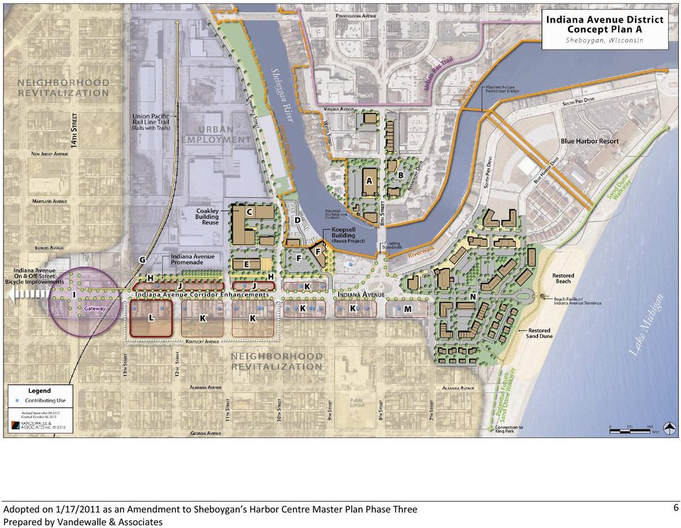
1 Indiana Avenue Redevelopment Plan and Implementation Strategy Sheboygan s Harbor Centre serves as a focal point of activity for residents and visitors to the community. The area includes 13 districts comprised of upper and lower downtown, lakeshore and riverfront districts, and many urban residential and employment districts. Indiana Avenue runs east-west through Harbor Centre just south of the Sheboygan River. Extending west from the Harbor Centre area, Indiana Ave connects western areas of the City and the nearby communities of Kohler and Sheboygan Falls to Sheboygan s lakefront, riverfront, and downtown. The Indiana Avenue Corridor was recognized as its own planning district in Phase Three of the Harbor Centre Master Plan (District #8 on the following map). Adopted in 2007, this Master Plan represents the third phase of the City of Sheboygan s comprehensive long-range vision for continued development and revitalization of the heart of the community. The Indiana Avenue corridor commands a significant presence within the Harbor Centre planning area as it provides access from the west to the Boatworks District, the South Pier District, the Southshore Neighborhood and the Urban Employment District. The focus of Indiana Avenue redevelopment is the reinforcement of the corridor as a major entryway into Harbor Centre through enhancement of the existing commercial district with rehabilitation of existing buildings (preservation of historic commercial building stock, redevelopment of vacant sites, and increased business development). 1

2 Interstate 43 is an important historical connection for the Indiana Avenue Corridor. There is not currently direct vehicular access to the Indiana Avenue Corridor from I-43, however there is potential to re-open the northbound off-ramp and once again provide a major entryway to the Corridor and Harbor Centre from northbound I-43 and from Kohler, to provide a more direct route to the Indiana Avenue business district, the South Pier, and the lakefront. Working within the context of the adopted Harbor Centre Master Plan, the City is considering a more targeted vision for the entire Indiana Avenue Corridor from Lake Michigan to Interstate 43, beginning with a phase one project area focused on the area between Lake Michigan and S 14 th Street. The purpose of this document is to present a redevelopment concept for the phase one project area illustrated in the following map. Further, this document lays out an implementation strategy for corridor redevelopment, which when implemented by the City and project partners, will serve as a catalyst for long-term corridor reinvestment and revitalization. 2

3 Corridor Vision The approximately eight-block stretch of Indiana Avenue between the lakefront and S 14 th Street includes a mix of diverse, generally neighborhoodoriented, businesses including restaurants, markets and personal service businesses adjacent to traditional urban neighborhoods and the community s historic employment district. The location of the corridor in the community will allow revitalization efforts to have broad impact across a number of economic and community development initiatives. Redevelopment Goals The following goals can help to guide development of a vision for the corridor: Revitalize a traditional neighborhood business corridor based on existing assets and leading initiatives as identified in the Harbor Centre Master Plan including the regional foods/public marketplace, urban employment and housing, and creative class entrepreneur initiatives; Advance Harbor Centre redevelopment and infill implementation particularly along Indiana Avenue as well as the adjacent Upper and Lower Downtown and South Pier Districts; Encourage neighborhood residential reinvestment in the neighborhoods surrounding Indiana Avenue; Support the advancement of an urban living services cluster in Lower Downtown; and Increase connectivity to draw the greater region to the Corridor and Harbor Centre and connect residents to urban employment. Redevelopment Vision Building upon these goals to develop a vision, the Indiana Corridor can become: The Indiana Avenue District A gateway corridor and major entryway into Harbor Centre with a vibrant and connected business district which is a destination in its own right, offering employment opportunities, amenities, and attractions that are authentic to the personality of the area and meet the needs of residents of the corridor and in the adjacent walkable neighborhoods, as well as offer unique experiences for the broader community and visitors. 3

4 Character Zones To advance the Indiana Avenue Corridor vision, character zones have been identified to help delineate the role of sub-sections in the corridor and pronounce the connections the corridor has with surrounding amenities. As illustrated in the Character Zone map, the Indiana Avenue Corridor can be considered as four distinct, but unified zones: Gateway Character Zone - The intersection of Indiana Avenue and S 14 th Street serves as the main entryway or gateway from the west and south into downtown, the lakefront and riverfront. Development of an attractive and welcoming gateway feature in this area would help orient visitors and convey that they re entering a unique area of the community. A streetscape theme beginning at this intersection should continue east, through to the lakeshore. Traditional Neighborhood Business Character Zone - The stretch of Indiana Avenue identified as the Traditional Neighborhood Business Character Zone, generally between S 14 th and S 9 th Streets, largely retains its historic commercial building stock. This small-scale business development unifies a large stretch of Indiana Avenue, providing a visual connection to Downtown and opportunities for small business owners and entrepreneurs within the community. Building form and design features for the area are highlighted in the Harbor Centre Master Plan and include continuity of architectural features and treatment and horizontal architectural elements. 8 th Street/Main Street Character Zone - The 8 th Street/Main Street Character Zone encompasses the north and south riverfront areas of the focus area. This area is closely connected to the activity that currently exists and is planned for the adjacent South Pier and Lower Downtown Districts. As a gateway to these areas the character of design and use should serve as a transition and connector to the surrounding areas. Lakefront Character Zone - The Lakefront Character Zone connects the Indiana Avenue Corridor to Sheboygan s south beach and lakefront. This area is currently balancing a mix of lakefront manufacturing facilities sandwiched by urban neighborhood to the south and hospitality and entertainment district to the north. Future redevelopment in this area should blend new developments into the fabric of the existing residential area and connect to amenities in the Indiana Avenue Corridor as well as South Pier. 4

5 Indiana Avenue Overarching Recommendations The primary overarching recommendations for the Indiana Avenue Corridor are detailed below; these core recommendations provide the basis for the attached Concept Plan map and the detailed implementation recommendations that follow. Building upon the goals and vision for Indiana Avenue, redevelopment implementation should focus on the following: 1. Develop a direct regional connection between Kohler and Sheboygan s lakefront South Beach area. Sheboygan is directly connected to Kohler and its internationally famous amenities, this connection provides a direct opportunity for partnership between communities and existing draws for residents and visitors to the region. Further, through the reestablishment of the I-43 northbound off-ramp, the Corridor could once again be directly connected to the greater region. 2. Leverage regional economic assets through advancement of the Sheboygan Regional Foods Initiative in the urban core. Building upon important regional economic assets including agricultural food production and processing, tourism, and hospitality, the Sheboygan Regional Foods Initiative could expand existing economic sectors, cultivate a skilled workforce, and encourage local job growth and entrepreneurship within the Indiana Avenue Corridor, promoting a live-work-play environment. 3. Explore the potential location of a business incubator or commercialization center. Building upon creative class entrepreneurial and regional foods assets and initiatives, an incubator or commercialization center in the corridor could further encourage entrepreneurship and homegrown business development well-aligned with stable and growing local and regional economies. 4. Leverage local diversity through food and cultural businesses and amenities. The Indiana Avenue Corridor area s diverse neighborhoods, including a high population of Hispanic and Asian residents, presents new businesses opportunities and potential for development of a unique destination within the area. 5. Strengthen downtown, urban living amenities, and residential districts. Through reinvestment and revitalization of the Indiana Avenue Corridor, the community will strengthen the local economy and local neighborhoods, encourage urban living, and add to the mix of urban amenities available to local residents and visitors. 6. Improve bike and pedestrian connections to and through Indiana Avenue. Develop connections to local and regional trail systems including the existing riverwalk, sand dune, and on-road bike routes in the City and connecting to regional networks in order to provide a safe transportation network. 5

6 6
7 7

8 Indiana Avenue Implementation Recommendations The previous Concept Plan illustrates the following implementation recommendations which have been developed to jumpstart implementation in the Indiana Avenue District. These recommendations provide the foundation for a detailed implementation work plan. A. Lower Downtown District opportunities are centered on the Alliant Energy and Martin Pontiac sites. Just across the Sheboygan River from Indiana Ave, this area has the potential to significantly increase activity in the lower end of downtown. The Alliant property provides a unique reuse opportunity for a small urban grocery store or food cooperative (co-op) and attached outdoor café. This use could leverage the site s riverfront and 8 th Street location and proximity to South Pier. The urban grocery would serve downtown residents, day-time employees, tourists, and even boaters who could tie up and shop on their way in or out of the harbor. Continue to coordinate with the property owner to advance acquisition and site preparation. Continue to outreach to potential grocers, local food cooperative, and developers to advance the urban grocery project. B. Downtown Convenience The Martin Pontiac site offers a redevelopment opportunity for a synergistic daily needs type development such as a drug store anchor tenant and an expanded fish market along with associated retail and residential and/or office along 8 th Street. Coordinate with property owner for eventual redevelopment of this site. C. Coakley Building Reuse The historic tannery, currently used as a storage facility, provides a long-term adaptive reuse opportunity for a business incubator and/or product commercialization center, ideally building off the success of the area s food-related and arts-related businesses and attractions. Coordinate with the property owner and identify project leaders to promote reuse or redevelopment of this property to increase employment density at this location in the Urban Employment District. D. Utilize vacated Commerce Street/9 th Street right-of-way between Illinois to Indiana Avenues, and consider vacating Commerce Street right-of-way an additional block north, to Maryland Avenue. Explore the potential for Yacht Club expansion in this location to increase boat storage and staging area within the vacated right-of-way. E. Regional Food Aggregation & Distribution Center This site is currently available and is well-suited to be employed in a regional food 8

9 economy capacity including use as an aggregation and distribution center, commercial kitchen and training facility, and community food bank. 1. Advance the Sheboygan Regional Foods Initiative to provide new workforce training and employment opportunities for local residents, support the region s strong local foods economy, and provide a catalytic destination development for the corridor area. 2. Consider acquisition and reuse of the existing building at 11 th and Illinois Avenue for regional foods related uses. F. Koepsell Building Reuse The Koepsell Building, a historic former multi-story manufacturing facility in a highly visible location downtown, presents an ideal location for a Regional Foods Initiative catalytic project. 1. Continue to explore identified concepts for this site which could leverage and support the region s local food production economy and its niche in local foods tourism, providing new workforce training and employment opportunities and encouraging entrepreneurship among the area s residents, including those of the adjacent low-tomoderate income, highly-diverse neighborhoods. Potential concepts include: Sheboygan Culinary School for training in cooking, food service, and hospitality. Brewery and restaurant development. Year-round public market/winter farmers market. Housing for hospitality workers in the region. 2. Acquire and demolish the buildings and relocate residents/businesses directly adjacent to the Koepsell Building parking lot (along 10th Street). Redevelopment of these parcels should be part of the greater reuse strategy for the Koepsell Building site. 3. Redevelop the vacant adjacent parcel in conjunction with the Koepsell Building project for parking and event space (market and other events). 9

10 G. Union Pacific Rail Line Trail Rails with Trails Connect Pennsylvania Avenue to Indiana Avenue via a Rail with Trail improvement along the existing rail line, as an extension of the planned northern segment which runs from North Avenue to Pennsylvania Avenue. (See the attached Indiana Avenue District Bicycle Infrastructure Map for conceptual alignment). H. Indiana Avenue Promenade Connect existing and future pedestrian and bicycle routes to the corridor via a public promenade just north of Indiana Avenue along the former rail rightof-way. Promenade amenities could include benches, lighting, plantings, and bike racks. 10

11 I. Transportation connections and public space amenities are critical to successful urban districts. The Indiana Corridor is well located along a major transportation route which presents challenges and opportunities. Recommendations related to connectivity and public improvements include: 1. Develop a gateway feature at the western edge of Harbor Centre, near S 14 th Street, announcing entry into the area and framing the Lake Michigan vista. 2. Improve streetscape along Indiana Avenue from the western gateway, including development of a signage and wayfinding program, trees and flowers, public art and banners, and street furniture to draw people to the corridor as well as the Riverfront, Lower Downtown and South Pier Districts. Incorporate and maintain on-street parking to support Corridor businesses. 3. Connect the beach and Sand Dune Walkway with a natural or paved path from the South Pier to King Park. 4. Construct a floating pedestrian boardwalk under the south side of 8 th Street bridge to connect the South Pier Riverwalk to the Indiana Avenue District. 5. Beach Pavilion/Indiana Avenue Terminus Provide public access to the lakefront at the eastern terminus of Indiana Avenue, including development of a public space celebrating the community s connection to Lake Michigan. Black & White Photos Source: Seaside Making a Town in America Edited by: David Mohney and Keller Easterling Princeton Architectural Press

12 J. Redevelopment Blocks These blocks are the highest priority for redevelopment and catalytic project advancement in the corridor. 1. Develop new buildings with relationship to the street, maintain historic structures, and relocate contributing uses into new buildings. 2. Advance redevelopment via property acquisition, site preparation, and developer recruitment. 3. Continue to implement the Indiana Avenue façade improvement program and create and implement a rear façade grant program for properties along the Indiana Avenue Promenade. 4. Model the design style of existing historic buildings along the corridor to influence design style of infill development. 5. As redevelopment occurs, utilize existing City standards and regulations to ensure adequate parking is provided in projects. Explore shared parking where possible. K. Reinvestment Blocks Key blocks for reinvestment in the existing structures. Buildings should largely remain with efforts focused on business recruitment. Efforts should build upon existing contributing uses. 1. Contributing Uses include businesses that can be considered business anchors to a local business district or corridor. Examples of contributing uses include coffee shops, restaurants, bars, health and fitness studios, grocery and other retail establishments. 2. Rezone to Central Commercial. 3. Advance reinvestment through property acquisition and developer/business recruitment. Examples of Existing Contributing Uses: Business Mix & Corridor Programming The development mix for the Indiana Avenue Corridor can draw organically from the existing international flair of the area, providing opportunities for a niche district centered on international restaurants or specialty retail, while also leveraging the strong arts culture of the community. Potential synergistic businesses and programming may include: Regional foods related markets and indoor public market Sheboygan Culinary School Craft brewery, beer garden, or similar local night spots Locally-owned restaurants such as ethnic restaurants and small cafes, some with outdoor dining Bookstore and/or library branch Bicycle/outdoor recreation shop and rentals Bakery Florist Local boutiques Furniture showrooms Art and home interiors galleries and live/work units Antique stores and flea markets Music venues including clubs, stages, bandstands Traditional and ethnic celebrations and events 12

13 L. Superblock Redevelopment The south section of this block offers a large redevelopment site with views to downtown and the lake. Following the relocation of existing uses on the north section, this location offers the opportunity to redefine an entire block. Redevelopment of the superblock should focus on a mix of retail, mixed-use along Indiana Avenue and residential along Kentucky Avenue. M. Long-Term Redevelopment With functional existing uses, this is a long-term redevelopment area which should be influenced by adjacent completed projects. Over time, retain uses in an urban building located along the street to continue Indiana Avenue streetscape and connection to Lake Michigan. N. Pentair Site Redevelopment The former Pentair manufacturing facility provides the unique opportunity for lakefront redevelopment. The following are two options for redevelopment of this important site. Option A: Mixed Use Opportunity for development of a new downtown anchor such as a medical facility or large office employer, some buildings may be developed with a mix of uses. Housing develop new residential units to bridge the South Pier and Southshore Neighborhood areas and provide additional rooftops to promote urban living. Option A 13

14 Option B: Large-scale use potential uses include a corporate headquarters/ office, entertainment uses such as a theater, retail, restaurant overlooking the lake with elevated outdoor seating, and restored sand dunes and beach. Parking provide parking for the entertainment use and beach access, direct connection to the Sand Dune Walkway. Option B 14

15 Ongoing Implementation Strategies An early step in redevelopment implementation is the development of an implementation team and detailed work plan. The implementation team is comprised of the professionals who are able to work the plan, who are able to bring in their specific expertise to advance specific projects and detailed tasks. To be successful, the team for each project will vary based on the specific expertise needed to make a project happen, however; generally the project team will include City staff from the Department of Planning and Development, staff and leadership from the Sheboygan County Economic Development Corporation, the redevelopment consulting team, and additional city staff as needed (finance, engineering, public works, legal, etc.). Additional significant support will be sought from local and regional private sector leadership, local and regional education and economic development agencies, and County, State, and Federal agencies as needed. The implementation recommendations laid out in this redevelopment plan should next be prioritized over a 12, 18, and 24 month timeline and culminate into a detailed work plan. The initial detailed work plan should focus on projects to be pursued in the first 12 months. Further, of particular importance in redevelopment implementation is the ongoing development of funding and financing strategies. These strategies should be developed on project-by-project basis and include: TIF for public improvements. U.S. Department of Housing and Urban Development Neighborhood Revitalization Strategy Area funding to reinvest in residential areas in and adjacent to the Indiana Avenue Corridor. Small business development assistance and promotion programs to encourage entrepreneurship and celebrate the local diversity and unique history of the area to generate new businesses and employment opportunities. Façade enhancement program for front and rear façades within the business district. State and Federal funding sources such as grants and tax credit programs for individual projects and initiatives including the Regional Foods Initiative, workforce training, residential development, and business development/entrepreneurship advancement. 15

16 16

17 Indiana Avenue Corridor DRAFT Preliminary Project Cost Estimates January 18, 2011 Gateway (Indiana Avenue and 14th Street) Item Quantity Units Cost Total Entrance arch - metal with stone columns 1 ea $50, $50,000 District monument sign - stone, illuminated 1 ea $6, $6,000 Landscaping 1 ls $5, $5,000 Stone pavers to match Koepsell plaza (20'x20') 800 sf $24.00 $19,200 Illuminated bollards to match Koepsell plaza 6 ea $2, $12,000 Subtotal $92,200 Contingencies (15%) $13,830 Administration/Design/Engineering (15%) $15,905 Total $121,935 Streetscape Enhancements (14th Street to Lake Michigan) Item Quantity Units Cost Total Benches - with concrete pads (every 2 blocks) 6 ea $1, $9,000 Planters - movable (five per block) 85 ea $ $42,500 Flowers - annuals (per planter) 85 ea $50.00 $4,250 Banners - street light mounted w/bracket 62 ea $ $18,600 Trash receptacles 6 ea $ $4,200 Wayfinding signs 2 ea $1, $2,000 Pedestrian lights (7th Street to Lake) 8 ea $6, $48,000 Lighting conduit (7th Street to Lake) 1,400 lf $12.00 $16,800 Lighting controls (7th Street to Lake) 2 ea $2, $5,000 Subtotal $150,350 Contingencies (15%) $22,553 Administration/Design/Engineering (15%) $25,935 Total $198,838 Promenade Enhancements (Commerce Street to railroad) Item Quantity Units Cost Total Pedestrian lights (alternating 150' O.C.) 16 ea $6, $96,000 Lighting conduit 3,200 lf $12.00 $38,400 Lighting controls 2 ea $2, $5,000 Street trees (100' O.C.) 32 ea $ $19,200 Asphalt bike path - 12' wide, 1,600 lf 19,200 sf $3.00 $57,600 Benches 7 ea $1, $8,400 Seating areas - stone pavers to match Koepsell plaza 350 sf $24.00 $8,400 Trash receptacles 7 ea $ $4,900 Landscape Buffer 1 ls $35, $35,000 Bike racks (near Koepsell) 2 ea $ $1,000 Crosswalks and bump outs (9th & 10th St) 2 ea $10, $20,000 Parking asphalt (9th - 10th St) 13,300 sf $3.00 $39,900 Parking curbs and gutter (9th - 10th St) 700 lf $12.00 $8,400 Sidewalk for business parking - 10' wide (9th - 10th St) 3,500 sf $6.00 $21,000 Grading, fill, & pavement removal 1 ls $50, $50,000 Subtotal $413,200 Contingencies (15%) $61,980 Administration/Design/Engineering (15%) $71,277 Total $546,457 Grand Total $867,229 Note: Estimates are for preliminary discussion and not for bid preparation. Estimates do not include utility improvements. 17
 $13,830 Administration/Design/Engineering (15%) $15,905 Total $121,935 Streetscape Enhancements (14th Street to Lake Michigan) Item Quantity Units Cost")
GARFIELD BOULEVARD. concept planning 54TH PL CALUMET AVE ELLSWORTH DR CTA STATION STUDY AREA GAS STATION GARFIELD BLVD PRAIRIE AVE
 GARFIELD BOULEVARD concept planning PRAIRIE AVE CTA STATION CURRENCY EXCHANGE CAFE ARTS INCUBATOR CALUMET AVE 54TH PL GAS STATION GARFIELD BLVD MUFFLER SHOP 55TH PL DR MARTIN LUTHER KING JR DR STUDY AREA
DIVISION STREET CORRIDOR STRATEGY Arlington, Texas May 17, 2012
 DIVISION STREET CORRIDOR STRATEGY Arlington, Texas May 17, 2012 Project Review: DCAC Meeting #2 March 8, 2012 Reviewed stakeholder meetings Online survey findings Market Assessment Macro Market Factors,
Guiding Principles. McCauley Area Focused Urban Design Plan. 1 Connect: Chinatown and Little Italy with downtown and surrounding areas
 McCauley Area Guiding Principles 1 Connect: Chinatown and Little Italy with downtown and surrounding areas 2 Strengthen: Cultural character in Chinatown and Little Italy 3 Develop: Strong East West pedestrian
DENSITY AND PUBLIC SPACE AT BISHOP STREET
 DENSITY AND PUBLIC SPACE AT BISHOP STREET Niehoff Urban Studio Senior Planning Capstone Spring 2015 Justin M. Lightfield U N I V E R S I T Y O F C I N C I N N A T I Table of Contents Overview... 3 Design
Downtown Core Sub-district
 3-10 Land Use Downtown Core Sub-district District development will be most intense and most urban in character in the Downtown Core. The objective is to establish this area as a citywide and regional retail
HARRIS TEETER AT LADY S ISLAND CITY OF BEAUFORT DRB CONCEPTUAL PROJECT NARRATIVE Submittal Date: September 2, 2015 Meeting Date: September 10, 2015
 HARRIS TEETER AT LADY S ISLAND CITY OF BEAUFORT DRB CONCEPTUAL PROJECT NARRATIVE Submittal Date: September 2, 2015 Meeting Date: September 10, 2015 PROPOSED REDEVELOPMENT The project consists of demolishing
Near West Side Comprehensive Plan Executive Summary (Revised) April 2004 City of Milwaukee DCD
 April 2004 City of Milwaukee DCD") Near West Side Comprehensive Plan Executive Summary (Revised) April 2004 City of Milwaukee DCD Boundaries The Near West Side Comprehensive Plan covers a broad area immediately west of Milwaukee s downtown.
Near West Side Comprehensive Plan Executive Summary (Revised) April 2004 City of Milwaukee DCD Boundaries The Near West Side Comprehensive Plan covers a broad area immediately west of Milwaukee s downtown.
Envision Venice Strategic Plan for Fiscal Year Ending. September 30, 2016. Preserving and Enhancing the Venice Quality of Life.
 Adopted April 28, 2015 October 1, 2015 through September 30, 2016 Envision Venice Strategic Plan for Fiscal Year Ending September 30, 2016 Preserving and Enhancing the Venice Quality of Life Table of Contents
Schenk-Atwood Neighborhood Business District Master Plan
 Schenk-Atwood Neighborhood Business District Master Plan Prepared for the Schenk-Atwood Revitalization Association (SARA) and the City of Madison SCHREIBER/ANDERSON ASSOCIATES, INC. BEST Real Estate Group,
Downtown Tampa Transportation Vision
 Downtown Tampa Transportation Vision Executive Summary August 1, 2006 Hillsborough County Metropolitan Planning Organization County Center, 18 th Floor Tampa, Florida 33602 813-272-5940 www.hillsboroughmpo.org
Rapid City Downtown Area Master Plan. Draft Plan Concepts April 2016
 Rapid City Downtown Area Master Plan Draft Plan Concepts April 2016 CALL TO ACTION! A Thriving Downtown = Regional Economic Prosperity Rapid City is competing nationally for a limited supply of young skilled
RDA Development Opportunities
 RDA Development Opportunities West Capitol Hill Development Opportunity Marmalade Block Development RDA hired Citiventure Associates to create a development strategy and implementation plan RDA property
 Walkable Communities Florida Department of Transportation State Safety Office Pedestrian and Bicycle Program April 1995 www.dot.state.fl.us/safety Twelve Steps for an Effective Program Page 1 Twelve Steps
Mississippi Drive Kickoff Event. 8/31/2015 & 9/1/2015 Meeting Minutes. Blue Zones: Dan Burden Presentation (Rotary Club Meeting)
") Mississippi Drive Kickoff Event 8/31/2015 & 9/1/2015 Meeting Minutes Blue Zones: Dan Burden Presentation (Rotary Club Meeting) Cedar Street new sidewalk/ada Target speed down to 20 MPH (Dan Burden) One
Mississippi Drive Kickoff Event 8/31/2015 & 9/1/2015 Meeting Minutes Blue Zones: Dan Burden Presentation (Rotary Club Meeting) Cedar Street new sidewalk/ada Target speed down to 20 MPH (Dan Burden) One
Education, Entrepreneurship & Urban Revitalization
 Education, Entrepreneurship & Urban Revitalization Over-The-Rhine Architecture, Urban Planning, and Economics students worked with Public school administrators to envision a new Entrepreneurial and a revitalized
Sharswood/Blumberg Choice Neighborhoods HOUSING TASK FORCE WORK SESSION #3
 Sharswood/Blumberg Choice Neighborhoods HOUSING TASK FORCE WORK SESSION #3 TUESDAY, AUGUST 26,2014 HAVEN PENIEL UNITED METHODIST 2301 W OXFORD STREET PHILADELPHIA, PA 19121 1 Welcome SHARSWOOD/BLUMBERG
Draft Goals and Objectives Wadena Comprehensive Plan City of Wadena, Minnesota. Land Use Goals:
 Draft Goals and Objectives Wadena Comprehensive Plan City of Wadena, Minnesota Land Use Goals: 1. Growth in Wadena will be undertaken in such a manner as to create a full range of living, working, shopping,
DOWNTOWN AND NEIGHBORHOODS
 DEVELOPMENT DOWNTOWN AND NEIGHBORHOODS There is no doubt that our Downtown is the heart of Litchfield County. It is vital that we begin to restore and renew the vibrancy of Torrington s center. The City
Lincoln Downtown Master Plan Update
 Lincoln Downtown Master Plan Update Table of Contents Executive Summary........................................... 1 Complete Streets Framework.................................... 3 Promenade Creating
28.0 Development Permit Area #2 (Neighbourhood District)
") 28.0 Development Permit Area #2 (Neighbourhood District) Goals and Objectives To provide a guide for infill and new development in the Neighbourhood District. To outline the nature, form and character
28.0 Development Permit Area #2 (Neighbourhood District) Goals and Objectives To provide a guide for infill and new development in the Neighbourhood District. To outline the nature, form and character
CITY COUNCIL PACKET MEMORANDUM
 CITY COUNCIL PACKET MEMORANDUM DOCUMENT: Final Plan and Final Plat SUBJECT: City Center Lenexa The Domain at City Center CONTACT PERSON: Beccy Yocham, Director of Community Development DATE: December 3,
LAKE SHORE DRIVE CTA RED LINE BROADWAY SHERIDAN FOSTER ARGYLE. Pedestrian Access Advisory Committee. April 25, 2014
 FOSTER LAKE SHORE DRIVE CTA RED LINE BROADWAY SHERIDAN ARGYLE ARGYLE STREET STREETSCAPE - S-1-323 Pedestrian Access Advisory Committee BROADWAY ARGYLE CTA RED LINE WINTHROP KENMORE SHERIDAN Broadway -
CHIPPEWA FALLS RIVERFRONT PARK
 CHIPPEWA FALLS RIVERFRONT PARK PHASE 1: MASTER PLAN REVIEW AND EVALUATION E-NEWSLETTER #1 Friday, April 4, 2014 MISSION STATEMENT: VISION 2020 CHIPPEWA FALLS Enhance the natural beauty, recreational opportunity
Citizen Advisory Group Meeting #1 December 8, 2011 6:00 p.m.
 Citizen Advisory Group Meeting #1 December 8, 2011 6:00 p.m. Meeting Agenda 1. Background Information 2. Policy Framework 3. Plan Development Process 4. Public Input Results 5. Vision Statement 6. Group
FY 2011 OHIO SMALL CITIES COMMUNITY DEVELOPMENT BLOCK GRANT COMPREHENSIVE DOWNTOWN REVITALIZATION PROGRAM
 CITYOFOBERLIN OHIO CITY OF OBERLIN, OHIO FY 2011 OHIO SMALL CITIES COMMUNITY DEVELOPMENT BLOCK GRANT COMPREHENSIVE DOWNTOWN REVITALIZATION PROGRAM Background In October, 2011, the City of Oberlin Planning
MEMORANDUM OF AGREEMENT Between THE CITY OF BALTIMORE And THE MID-ATLANTIC FEDERAL PARTNERSHIP FOR THE ENVIRONMENT
 MEMORANDUM OF AGREEMENT Between THE CITY OF BALTIMORE And THE MID-ATLANTIC FEDERAL PARTNERSHIP FOR THE ENVIRONMENT The Mid-Atlantic Federal Partnership for the Environment ( MAFPE ) and the City of Baltimore
Economic Development Element
 The Strawberry Ladies by Tara Stood Economic Development Element Economic development enhances San Clemente s quality of life by providing local goods and services and expanding employment and business
CITY OF FLORENCE NEIGHBORHOOD REVITALIZATION STRATEGY SECOND PUBLIC MEETING
 CITY OF FLORENCE NEIGHBORHOOD REVITALIZATION STRATEGY SECOND PUBLIC MEETING Prepared for: City of Florence July 7th, 2014 AGENDA Review Feedback from First Community Meeting Present Catalytic Project Areas
3.1 Historical Considerations
 3. Recommended Scope of Bridge improvements 3.1 Historical Considerations In the fall of 2000, an outside consultant, Fraser Design, suggested that the existing 4 th St. Bridge is potentially eligible
S U S TA I N A B L E C O M M U N I T I E S : EAST NEW YORK
 S U S TA I N A B L E C O M M U N I T I E S : EAST NEW YORK REGIONAL ACCESS MIDTOWN 30 40 mins (A) LOWER MANHATTAN 18 25 mins (A) JAMAICA 9 Mins (LIRR) NASSAU CENTER 32 mins (LIRR) DOWNTOWN BROOKLYN 15-20
21.04 LAND USE. Managing amenity through land use strategies
 21.04 LAND USE This section contains objectives and strategies for land use, under the themes of: Housing and community Retail, entertainment and the arts Office and commercial use Industry Education and
ECONOMIC DEVELOPMENT. in this chapter. 8.1 Overview of Economic Conditions. 8.2 Priority Economic Development Needs
 8 ECONOMIC DEVELOPMENT in this chapter 8.1 Overview of Economic Conditions 8.2 Priority Economic Development Needs 8.3 Economic Development Goals and Policies chapter 8 economic development Creating new
REFERENCES-COMMERCIAL. Montgomery County Community College. 60,000 Sq. Ft. Montgomery County Community College 12,000 Sq. Ft.
 Montgomery County Community College West Campus Expansion 60,000 Sq. Ft. Warehouse adaptive reuse of the former Vaughn Knitting Mill, a major architectural component of Pottstown s Industrial Heritage.
IT S HARD TO BELIEVE THE INNER HARBOR IS 40 YEARS OLD
 inner harbor 2.0 IT S HARD TO BELIEVE THE INNER HARBOR IS 40 YEARS OLD In 1973, the Inner Harbor public promenade was completed, setting the framework for all development to follow. Heralded as a model
STRATEGIC PLAN 2015 2020 2030
 STRATEGIC PLAN 2015 2020 2030 Boca Raton, Florida May 2015 Lyle Sumek Associates, Inc. Phone: (386) 246-6250 9 Flagship Court Fax: (386) 246-6252 Palm Coast, FL 32137 E-mail: sumekassoc@gmail.com Table
VANDERBILT COMPARISON
 Village of Vanderbilt Comparison One County, One Vision Master Plan (2000) 1 15 Improve recreation in Otsego County by assessing the availability and need to improve bike paths, county recreation facilities,
REVISIONING SAINT PAUL S EAST SIDE
 REVISIONING SAINT PAUL S EAST SIDE CREATING A WALKABLE TOWN CENTER Urban Greenewal: Revitalizing communities through green and sustainable strategies Prepared by EAST SIDE NEIGHBORHOOD DEVELOPMENT COMPANY,
Request for Information
 Request for Information Date of Issue: February 13, 2015 Responses Due: May 29, 2015 Overview Forest West Properties Inc. (FWP) is soliciting qualifications from qualified developers for the development
BUSINESS TECHNOLOGY CENTER REDEVELOPMENT PLAN SUMMARY
 BUSINESS TECHNOLOGY CENTER REDEVELOPMENT PLAN SUMMARY F rom autumn 2014 through spring 2015, HBDi worked closely with its consultant team to create a redevelopment vision for the Palm Center Business Technology
S. BLOCK 68 REDEVELOPMENT PROJECT AREA
 S. BLOCK 68 REDEVELOPMENT PROJECT AREA 1. Revitalization Project Description The Block 68 Redevelopment Project Area is located on the block bounded by 10 th, 11 th, M, and N Streets, and is comprised
PLANNING FOR NEW DEVELOPMENT AT THE COTTONWOOD MALL SITE
 APPENDIX F PLANNING FOR NEW DEVELOPMENT AT THE COTTONWOOD MALL SITE Table of Contents The Setting Background Planning Objectives Neighborhood Protection The Concept Plan Exhibits Cottonwood Mall Site 1
315 First Ave NE Minneapolis, MN 55413
 View Neighborhood View Project Details 315 First Ave NE Minneapolis, MN 55413 22,000 SF of Retail and Restaurant Space Available for Lease View Renderings View Maps View Area Plans Contact NORTHEAST MINNEAPOLIS
BASSETT CREEK VALLEY MASTER PLAN OPEN HOUSE
 BASSETT CREEK VALLEY MASTER PLAN OPEN HOUSE February 23, 2006 PROJECT INTRODUCTION Project Area 230 acres $50 million estimated market value (approximately) 50 acres parkland 100 residences (estimated)
Topic 2 11/28/2012 Blocks & Street Network
 TOPIC 2 Blocks & Street Network Implementation Note: 1. Some recommendations are summarized in the tables herein. For complete recommendation language, please see the. 2. Recommendations referenced in
01/31/13 ACHIEVING THE VISION FOR RESTON. Reston Master Plan Special Study Task Force
 ACHIEVING THE VISION FOR RESTON Reston Master Plan Special Study Task Force The Reston Master Plan Special Study Task Force was appointed by Hunter Mill District Supervisor Catherine Hudgins to review
Motorcycle & Pedestrian Master Plans in Indianapolis, Indiana
 PROJECT PURPOSE The Warsaw + Winona Lake Bicycle and Pedestrian Master Plan establishes a comprehensive framework for a connected bicycle and pedestrian system that will be used for both recreation and
Downtown Public Spaces Improvement Program
 Coming together is a begining; keeping together is progress; working together is success. - Henry Ford Downtown Public Spaces Improvement Program a program funded by the Houston-Galveston Local Development
2010 Salida Community Priorities Survey Summary Results
 SURVEY BACKGROUND The 2010 Salida Community Priorities Survey was distributed in September in an effort to obtain feedback about the level of support for various priorities identified in the draft Comprehensive
Theme 1: Activities. Background
 Theme 1: Activities The Activities Theme relates to the type of land uses that are preferred in different parts of Kyneton, including retail, residential, office and civic uses. Background The Retail and
Smart Growth Illustrated: Developer s Guidebook. City of Bentonville Community Development Department October 2006
 Smart Growth Illustrated: Developer s Guidebook City of Bentonville Community Development Department October 2006 1 Table of Contents What is Smart Growth...3 Six Goals of Smart Growth 5 Ten Tools of Smart
Los Angeles Union Station, CA Sustainable Neighborhood Assessment. April 22-23, 2014
 Los Angeles Union Station, CA Sustainable Neighborhood Assessment April 22-23, 2014 Sustainable Neighborhood Assessment Through the Sustainable Neighborhood Assessment Tool developed by Global future development
SECTION 2 CORRIDOR A
 SECTION 2 CORRIDOR A 2.1 CORRIDOR A (HILLSBOROUGH RIVER TO 40 TH STREET IN TAMPA) The boundaries for Corridor A can be seen in Figure 2-1. They are as follows: North: I-4 South: Crosstown Expressway (now
Indianapolis SDAT. Neighborhood Restoration
 Neighborhood Restoration Working Toward a Sustainable Future live * work * play October 30 th, 2009 Message Hear concerns Build consensus Provide Recommendations Transition from Fragmentation/disconnect
Strategic Planning. Frequently Asked Questions. Member Services
 The SID is proactively working to combat these challenges and is poised to take the necessary steps to ensure downtown transitions from these difficult times to a vibrant and active center Strategic Planning
1. Land Use. Chapter 1: Land Use 1-1 Adopted 10/2/09 Amended 3/22/11, 8/16/11
 1. Land Use Minneapolis will develop and maintain a land use pattern that strengthens the vitality, quality and urban character of its downtown core, commercial corridors, industrial areas, and neighborhoods
MICHIGAN PROSPERITY INITIATIVE: Region 2 -- Major Assets and Strategies
 MICHIGAN PROSPERITY INITIATIVE: Region 2 -- Major Assets and Strategies Top Draft Priority Strategies, Region 2 Planning Commission Identify business needs for workforce development across the region.
Downtown Sebring CRA Business Recruitment and Retention Plan June 2010
 Downtown Sebring CRA Business Recruitment and Retention Plan June 2010 As the summer months draw to a close and the summer streetscape project ends, Downtown Sebring will need to implement a plan of action
Frederick. Frederick. Maryland. Smart Growth Successes. Frederick. Maryland Department of Planning
 Frederick Frederick Maryland Smart Growth Successes Frederick Maryland Department of Planning Smart, Green & Growing Martin O Malley Governor Anthony G. Brown Lt. Governor Maryland Department of Planning
BEST PRACTICES. Smart Transportation is a key concept for the Paoli Roadway Improvement Project.
 Smart Transportation Smart Transportation is a key concept for the Paoli Roadway Improvement Project. PennDOT s Smart Transportation Guidebook (2008) outlines a comprehensive approach to transportation
Camden Community Conversation. Vibrancy Survey Results May 21, 2009
 Camden Community Conversation Vibrancy Survey Results May 21, 2009 Prepared by Friends of Midcoast Maine For the Citizens of Camden Electronic survey and analysis by Jane Lafleur and Deborah Dodge. May
SCHOOL OF ARCHITECTURE & COMMUNITY DESIGN COLLEGE OF THE ARTS UNIVERSITY OF SOUTH FLORIDA
 SCHOOL OF ARCHITECTURE & COMMUNITY DESIGN COLLEGE OF THE ARTS UNIVERSITY OF SOUTH FLORIDA PROJECT OVERVIEW OVERVIEW The FCCD+R, in coordination with the FDOT District 7, are to facilitate numerous meetings
10. Opportunity Site Development Concepts
 10. Opportunity Site Concepts Policy: The City should encourage and support specific projects that will anchor development in strategic locations throughout the City Center. Introduction A number of special
Economic Vitality Strategy
 CITY OF CONCORD Economic Vitality Strategy 2010 Update Community Development Department 1950 Parkside Drive, MS/01B Concord, CA 94519-2578 CITY OF CONCORD MISSION: The City of Concord is an integral part
Arkansas River Corridor Vision & Master Plan
 A r k a n s a s R I v e r C o r r I d o r P l a n Arkansas River Corridor Vision & Master Plan July 2005 Indian Nations Council of Governments A r k a n s a s R I v e r C o r r I d o r P l a n Partnership
Recently Constructed, High Quality Office Space For Lease/Sale in Old Town
 Recently Constructed, High Quality Office Space For Lease/Sale in Old Town 401 Mason Court, Unit 101, Fort Collins, Colorado 80521 Available for Sale or Lease: Size: 1,238 + SF Sale Price: Negotiable Lease:
VISION, DESIGN PRINCIPLES & OVERALL PLANNING STRATEGY
 3 VISION, DESIGN PRINCIPLES & OVERALL PLANNING STRATEGY The overall planning strategy for the Bank Street CDP is to ensure that future development is undertaken in a coordinated and planned approach, supported
IV. Market Analysis. A. Executive Summary. The Economy. The Site
 IV. Market Analysis A. Executive Summary The Economy The St. Louis metropolitan area population has grown at the moderate annual rate of 4.4% over the last eight years while employment (the best measure
CITY OF BRAMPTON STREET CORRIDOR MASTER PLAN
 1.0 INTRODUCTION... 1 1.1 Purpose of Document... 1 1.2 Master Plan Goal...1 1.3 Design Objectives... 2 1.4 Design Approach... 2 2.0 PROJECT SCOPE...2 2.1 City Context 2 2.2 Regional Context 2 3.0 DESIGN
TABLE OF CONTENTS. Executive Summary 1-3. Introduction 4-6. Illustrative Site Plan 7. East-West Streets 8. Cooper Street 9-10. Market Street 11-14
 TABLE OF CONTENTS Executive Summary 1-3 Introduction 4-6 Illustrative Site Plan 7 East-West Streets 8 Cooper Street 9-10 Market Street 11-14 Federal Street 15-16 MLK Boulevard 17-20 North-South Streets
Appendix C Related Studies
 Appendix C Related Studies Intermodal Transit Village Concept Plan Appendix C Related Studies This appendix summarizes studies that are current at the time of this Plan. Intermodal Transit Village Concept
Opal Service District Plan
 8 The Opal Service District includes a variety of planned land uses including commercial, mixed-use, flex office, industrial, and hospitality. This Plan seeks to simplify the land use categories to allow
FLORIDA ATLANTIC UNIVERSITY
 3 Supporting Data The purpose of the Element is to develop an understanding of the overall physical form of the development within the University and its relationship to the surrounding community, and
CITY OF LANCASTER, PA
 CITY OF LANCASTER, PA HIGH STYLE, SMALL CITY, BIG SURPRISES LancasterCityAlliance.org WELCOME TO THE CITY OF LANCASTER A compact city of seven square miles and 60,000 residents, Lancaster City is located
4.0 THE UNIVERSITY AVENUE SPECIFIC PLAN VISION
 4.0 THE UNIVERSITY AVENUE SPECIFIC PLAN VISION 4.1 Overall Vision In keeping with University Avenue's key role in the City of Riverside as the major thoroughfare connecting Downtown Riverside and UCR,
5 th Ward Alderman Neighborhood Representative Local media outlets
 . ACTION PLAN MATRIX Action Plan Matrix ACTION PLAN MATRIX Project Implementation Measure Project Leader / Potential Partners Time Frame Possible Funding Source Plan Reference Adopt Neighborhood Strategic
East Somerville. What is important to me Survey Results
 What is important to me Survey Results The What is important to me survey was used at the Somerville by Design: Crowdsourcing meeting on May 28, 213. About 35 people filled out the survey at that meeting,
I:\ED Subcommittee\ED Subcom Agendas\Supporting Documentation\20100309_ED_SD_Economic_Development_Initiatives.docx
 Economic Development & Community Development Initiatives I. Community Development Extensions and Reactivations o Expand time limit for non-conforming status o Expand time limit for cease of operation of
Corridor Goals and Objectives
 Corridor Goals and Objectives This chapter presents the goals and objectives, developed by the Corridor Study Committee, that serve as the purpose and intent of the Corridor Plan. This plan covers a twenty
12 February 8, 2012 Public Hearing APPLICANT:
 12 February 8, 2012 Public Hearing APPLICANT: PROPERTY OWNER: VIRGINIA BEACH ASSOCIATES, LC REQUEST: Conditional Change of Zoning (I-1 to Conditional A-36) STAFF PLANNER: Faith Christie ADDRESS / DESCRIPTION:
Revere Beach Transit-Oriented Development Parcels Revere, Massachusetts. Design and Development Guidelines. Part Two.
 Revere Beach Transit-Oriented Development Parcels Revere, Massachusetts Design and Development Guidelines Request for Qualifications and Expressions of Interest with Preliminary Development Plans Part
CITY OF BUFFALO 2007 FEDERAL AGENDA BYRON W. BROWN MAYOR
 CITY OF BUFFALO 2007 FEDERAL AGENDA BYRON W. BROWN MAYOR INTRODUCTION Mayor Byron W. Brown has established clear federal legislative priorities that support his goal of reviving the City of Buffalo s economy.
Borough of Red Bank 1. Overview of Red Bank and Its Waterfront
 Borough of Red Bank 1. Overview of Red Bank and Its Waterfront 1.1 Geographic Overview Incorporated in 1908, the Borough of Red Bank is located in Northeastern Monmouth County. Bounded by the Navesink
Fast Track A Successful Redevelopment: The Palm Beach Outlets Story
 Fast Track A Successful Redevelopment: The Palm Beach Outlets Story SPEAKERS Rick Greene, AICP City of West Palm Beach Brian Seymour, Esq. Gunster Ken Tuma, PE UDKS Josh Long, AICP Gunster Grand Opening
APPENDIX F RIGHTS-OF-WAY PRESERVATION GUIDELINES
 Los Angeles County Metropolitan Transportation Authority (Metro) 2009 Transportation Improvement Program Call for Projects APPENDIX F RIGHTS-OF-WAY PRESERVATION GUIDELINES Los Angeles County Metropolitan
Amazing Place. Six Cities Using the New Recipe for Economic Development
 Amazing Place Six Cities Using the New Recipe for Economic Development JUNE 2016 Nashville, TN Capitalizing on cool In 2015, an average of 30 people moved to Nashville every day and they weren t all budding
What we build today will create Denver s tomorrow. Signature development projects will strengthen our economy, create jobs and improve neighborhoods.
 Mayor Hancock s Vision for Building a World-Class City What we build today will create Denver s tomorrow. Signature development projects will strengthen our economy, create jobs and improve neighborhoods.
AREA: 2.37 acres NUMBER OF LOTS: 1 FT. NEW STREET: 0 LF. Single-family, Non-conforming machine shop
 FILE NO.: Z-8958 NAME: Rock Structure Repair Short-form PID LOCATION: Located at 8024 Stanton Road DEVELOPER: Rock Structure Repair Attn. Rudy Gutierrez 3 Kipling Court Little Rock, AR 72209 ENGINEER:
MILWAUKEE. Plan. comprehensive DEPARTMENT OF CITY DEVELOPMENT MARCH, 2010 EXECUTIVE SUMMARY
 MILWAUKEE Plan DEPARTMENT OF CITY DEVELOPMENT MARCH, 2010 comprehensive CITYWIDE POLICY PLAN EXECUTIVE SUMMARY INTRODUCTION AND OVERVIEW I. OVERVIEW OF COMPREHENSIVE SMART GROWTH PLAN SERIES The series
WELCOME WELCOME TO THE PUBLIC EXHIBITION FOR THE ILONA ROSE HOUSE REDEVELOPMENT. ILONA ROSE HOUSE www.ilonarosehouse.com
 WELCOME Manette Street from Charing Cross Road WELCOME TO THE PUBLIC EXHIBITION FOR THE REDEVELOPMENT. Corner of Charing Cross Road and Manette Street SOHO ESTATES Soho Estates began as a collection of
METROPOLITAN REDEVELOPMENT PLAN II OLD ALBUQUERQUE HIGH SCHOOL
 METROPOLITAN REDEVELOPMENT PLAN II OLD ALBUQUERQUE HIGH SCHOOL Preface This revised plan for redevelopment of the Old Albuquerque High School Metropolitan Redevelopment Area has been prepared pursuant
APPENDIX 2. NJDEP Environmental and Historic Review Application for EDA and DCA/NEP Programs
 APPENDIX 2 NJDEP Environmental and Historic Review Application for EDA and DCA/NEP Programs 1. Agency Name: New Jersey Economic Development Authority 2. Date of Application Submittal to DEP: September
Attachment 1. Principles, Priorities, and Actions for Economic Renewal and Development for the City of Seattle
 Attachment 1 Principles, Priorities, and Actions for Economic Renewal and Development for the City of Seattle Quality of Life A livable city requires that we retain and improve the character of Seattle,
Nine Mile Station Urban Renewal Plan
 Nine Mile Station Urban Renewal Plan Aurora, Colorado April 2014 Prepared for: Aurora Urban Renewal Authority Aurora, Colorado City Council Nine Mile Station Urban Renewal Plan Draft date: 3-31-2014 Aurora,
OFFICIAL PLAN REVIEW ENVIRONMENTAL STAKEHOLDERS FEEDBACK REPORT
 OFFICIAL PLAN REVIEW ENVIRONMENTAL STAKEHOLDERS FEEDBACK REPORT TABLE OF CONTENTS 1. ABOUT THE WORKSHOP Page 3 2. GREEN SPACE/OPEN SPACE AS A COMMUNITY CONNECTOR Page 5 3. SUSTAINABLE COMMUNITY DESIGN
The Physical and Economic Assessment
 CHAPTER 2 The Physical and Economic Assessment 9 Chicago River North Branch 300 360 Chicago River Main Branch Lake Michigan Figure 2.2 The Street Grid extending in all directions allows the downtown to
05 AREA/SITE SPECIFIC GUIDELINES
 05 AREA/SITE SPECIFIC GUIDELINES Site 1 - Glass Yard The leisure centre that is currently located on this site should move to a more central location in the town centre close to the existing public squares.
Comprehensive Plan Policies that support Infill and Mixed Use
 Comprehensive Plan Policies that support Infill and Mixed Use Introduction A comprehensive plan provides a broad vision for the future growth of a community. It is often formulated using community visioning
Marketing Plan for Municipal Growth: City of Middletown, New York
 Marketing Plan for Municipal Growth: City of Middletown, New York Hudson Valley Pattern for Progress Regional Fellows Program Urban Action Agenda for the Hudson Valley June 2015 Antoinette Caruso Alicia
B. Fairport RESTORE III Parker Street (W808) August 18, 2011. General Project Plan
 August 18, 2011. General Project Plan") General Project Plan Grantee: ESD Investment: Project Location: Village of Fairport (the Village ) A grant of up to $156,700 to be used for a portion of the cost of asbestos removal, demolition of vacant
General Project Plan Grantee: ESD Investment: Project Location: Village of Fairport (the Village ) A grant of up to $156,700 to be used for a portion of the cost of asbestos removal, demolition of vacant
THE RUSKIN COMMUNITY PLAN
 THE RUSKIN COMMUNITY PLAN Introduction Ruskin is a historic community situated on the shores of Tampa Bay, the Little Manatee River and the Ruskin Inlet, approximately 16 miles southeast of Tampa. The