Innovative observations and analysis of human thermal comfort in Amsterdam
|
|
|
- April Hunt
- 9 years ago
- Views:
Transcription

1 Innovative observations and analysis of human thermal comfort in Amsterdam Bert Heusinkveld, Gert-Jan Steeneveld, Reinder Ronda, Jisk Attema and Bert Holtslag ICUC annual meeting, Toulouse 2015

2 Number of tropical days (left) and trend in Summer days in NL (right) Annual average Number of days with a max. temperature of 30C

3 Number of tropical days (left) and trend in Summer days in NL (right) Annual average Number of days with a max. temperature of 30C Amsterdam Rotterdam 25 km

4 Big cities are urban heat islands (UHI), recent example: Rotterdam Summer UHI max ~8K

5 25 km Urban land use fraction (-) Urbanization Amsterdam km Year Maps: Land use maps from Kramer H., Hazeu, G., Wageningen UR - Alterra

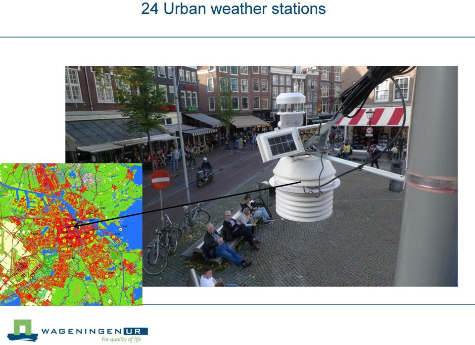
6 24 Urban weather stations
7 WMO reference 20 km Urban Heat Islands or Urban Cool Islands? Summer 2014, T max_urban -T max_wmo 23 km Landuse maps LGN7, 2012, Alterra

8 WMO reference 20 km Urban Heat Islands or Urban Cool Islands? Summer 2014, 95percentile(T max_urban -T max_wmo ) 23 km Landuse maps LGN7, 2012, Alterra
 23 km Landuse maps LGN7,")
9 WMO reference 20 km Urban Heat Islands or Urban Cool Islands? Summer 2014, T min_urban -T min_wmo 23 km Landuse maps LGN7, 2012, Alterra

10 WMO reference 20 km Urban Heat Islands Summer 2014, 95percentile(T min_urban -T min_wmo ) 23 km Landuse maps LGN7, 2012, Alterra
 23 km Landuse maps")
11 WMO reference 20 km Nocturnal Urban Heat Islands Summer 2014, daily_maximum(t urban -T wmo ) 23 km Landuse maps LGN7, 2012, Alterra

12 WMO reference 20 km Nocturnal Urban Heat Islands Summer 2014, 95percentile(daily_maximum(T urban -T wmo )) 23 km Landuse maps LGN7, 2012, Alterra
) 23 km Landuse maps LGN7,")
13 20 km Nocturnal Urban Heat Islands Summer 2014, 95percentile(daily_maximum(T urban -T wmo )) 23 km Landuse maps LGN7, 2012, Alterra
) 23 km Landuse")
14 NDVI (-) Fenology of vegetation, detection from space to quantify urban vegetation Groenmonitor, initiative of Alterra, Wageningen UR, the Netherlands. Gerbert Roerink & Sander Mucher, Satellites: Formosat (8m), DMC (22m), Landsat7-ETM

15 UHI 95% at Tmin (K) Land-use and nocturnal UHI in Amsterdam y = -4.2x R² = NDVI 100m grid (-)

16 Cargo bicycle measures human thermal comfort, importance of radiation (direct measurement of T mrt ) GPS: location, time, speed Air temperature, humidity (aspirated screen) Wind speed, -direction Radiation Radiation Wheel speed Design: Bert Heusinkveld

17 T ( C) Campus at 22 July 2013, 11 UTC: T mrt : 62 C, PET: 45 C Ta Tmrt Campus 0:00 12:00 0:00 12:00 0:00 12:00 0:00 Similar values at Campus and rural station, but not the extremes

18 2 bicycle measurement tracks 8 km

19 Real-time thermal comfort measurements in Amsterdam Universal Thermal Climate Index (UTCI) scale:
 scale: www.")
20 Real-time thermal comfort measurements in Amsterdam

21 Real-time thermal comfort measurements in Amsterdam
22 Real-time thermal comfort measurements in Amsterdam UTCI
23 Windspeed (m/s) Cloud cover (Octas) Freq. dist (or seconds) Freq. dist. (or seconds) Amsterdam (18-19 July 2014) T ( C) u10 CC T_rural Stations hours, July 2014 (hh) Qgl Global radiation (W/m2) Tmrt UTCI 19 July 11:00-12:22 (Moderate to very strong heatstress)
24 App development: Forecasting Thermal comfort in a complex environment The idea is to present a location specific 3 h weather forecast of human thermal comfort up to 36 h ahead. Requirements: Use of a modern thermal comfort scale: UTCI (Universal Thermal Climate Index) No numbers (only a colour scale) Thermal stress levels as text (UTCI scale) Includes land-use effects (temperature, wind speed, radiation) Based on: Thermal comfort measurements/analysis: Bert Heusinkveld, session NONTM11 WRF simulation: Reinder Ronda, session TUKUP4 Land-use map 25 m resolution: Jisk Attema, session GD5 Global model forecast: GFS, NCEP, U.S.A. Technical realisation: Master student Gert Sterenborg
25 App Thermal comfort 1. Use location data Smartphone 2. Download forecast 3. Display forecast Add symbol sun Wind/obstructed


26 App: Thermal comfort Today 16 to 19 h Wind protected Windy location
27 Concluding remarks Urban space during heat wave conditions: Amsterdam has a substantial nocturnal urban heat island effect (canals don t help) Thermal comfort varies strongly among built up areas Parks with short vegetation are urban hot spots (during daytime) Narrow street canyons can be more thermally comfortable than a WMO weather station location (air temperature and UTCI)
28 Thank you for your attention! 160 m 600 m [email protected] L
29 Very detailed geographical data available Lidar altimetry map: Waterschapshuis Rijkswaterstaat the Netherlands Aerial photographs: Aerodata
30 T ( C) Ta Td : : : : : : : Q global Radiation (W m-2) 800 Q diffuse : : : : : : :00 Date & Time Ql_in Ql_out : : : : : : :00 6 v (m s-1) Radiation (W m-2) Heat wave July 2013 Observations Rural station Date & Time 4 Wind speed : : : : : : :00 Date & Time
31 Mean radiant temperature and PET, rural station 50 PET T ( C) 40 Ta Ta T ( C) 50 Tmrt : : : : : : :00 Date & Time PET: Calculated with a human thermal energy balance model Rayman (Matzarakis et al.)
32 Temperature ( C) Realtime thermal comfort measurements in Amsterdam : Frequency density distrubution (-) T ( C) T_rural Stations Qgl hours, July 2014 (hh) Global radiation (W/m2) Error bars: 95percentile of a 1 hour measurement of 24 stations
33 Urban heat island Amsterdam Temperature ( C) 35 15: Temperature ( C) Frequency density distrubution (-) :59 T ( C) Frequency density distrubution (-) T_rural Stations Qgl hours, July 2014 (hh) Global radiation (W/m2) Error bars: 95-percentile of a 1 hour measurement of 24 stations
34 Measured variation in thermal comfort UTCI
35 Urban heat islands (UHI) on climate maps?
Monsoon Variability and Extreme Weather Events
 Monsoon Variability and Extreme Weather Events M Rajeevan National Climate Centre India Meteorological Department Pune 411 005 [email protected] Outline of the presentation Monsoon rainfall Variability
CHANGING THERMAL BIOCLIMATE IN SOME HUNGARIAN CITIES Á NÉMETH
 ACTA CLIMATOLOGICA ET CHOROLOGICA Universitatis Szegediensis, Tomus 44-45, 2011, 93-101 CHANGING THERMAL BIOCLIMATE IN SOME HUNGARIAN CITIES Á NÉMETH Climatology Division, Hungarian Meteorological Service,
163 ANALYSIS OF THE URBAN HEAT ISLAND EFFECT COMPARISON OF GROUND-BASED AND REMOTELY SENSED TEMPERATURE OBSERVATIONS
 ANALYSIS OF THE URBAN HEAT ISLAND EFFECT COMPARISON OF GROUND-BASED AND REMOTELY SENSED TEMPERATURE OBSERVATIONS Rita Pongrácz *, Judit Bartholy, Enikő Lelovics, Zsuzsanna Dezső Eötvös Loránd University,
The Urban Canopy Layer Heat Island IAUC Teaching Resources
 The Urban Canopy Layer Heat Island IAUC Teaching Resources The urban heat island (UHI) is the most studied of the climate effects of settlements. The UHI refers to the generally warm urban temperatures
Urban Climatic Map of Arnhem City
 Urban Climatic Map of Arnhem City Renè Burghardt, Lutz Katzschner, Sebastian Kupski, University Kassel Ren Chao, Tejo Spit University Utrecht May 2010 1 1 INTRODUCTION In the framework of urban planning
Exploring the Urban Heat Island Intensity of Dutch cities
 Exploring the Urban Heat Island Intensity of Dutch cities Assessment based on a literature review, recent meteorological observations and datasets provided by hobby meteorologists Alterra report 2170 ISSN
Armenian State Hydrometeorological and Monitoring Service
 Armenian State Hydrometeorological and Monitoring Service Offenbach 1 Armenia: IN BRIEF Armenia is located in Southern Caucasus region, bordering with Iran, Azerbaijan, Georgia and Turkey. The total territory
Climate change and heating/cooling degree days in Freiburg
 339 Climate change and heating/cooling degree days in Freiburg Finn Thomsen, Andreas Matzatrakis Meteorological Institute, Albert-Ludwigs-University of Freiburg, Germany Abstract The discussion of climate
LATITUDES INTERNATIONAL DESIGN CHALLENGE 2015-16
 LATITUDES INTERNATIONAL DESIGN CHALLENGE 2015-16 Design Challenge Resilient working environments: carving the city for small businesses in London Submitted by: University of Westminster MSc Architecture
IMPACT OF SAINT LOUIS UNIVERSITY-AMERENUE QUANTUM WEATHER PROJECT MESONET DATA ON WRF-ARW FORECASTS
 IMPACT OF SAINT LOUIS UNIVERSITY-AMERENUE QUANTUM WEATHER PROJECT MESONET DATA ON WRF-ARW FORECASTS M. J. Mueller, R. W. Pasken, W. Dannevik, T. P. Eichler Saint Louis University Department of Earth and
MODELLING OF THE MAXIMUM URBAN HEAT ISLAND
 MODELLING OF THE MAXIMUM URBAN HEAT ISLAND ICB-ICUC'99, Sydney, 8-12 November 1999 J. Unger 1, Z. Sümeghy 1, Á. Gulyás 1, Z. Bottyán 2 and L. Mucsi 3 1. Department of Climatology and Landscape Ecology,
Development of empirical models for an estate level air temperature prediction in Singapore
 Development of empirical models for an estate level air temperature prediction in Singapore Steve Kardinal Jusuf* and Wong Nyuk Hien, National University of Singapore, Singapore, *Corresponding author
A system of direct radiation forecasting based on numerical weather predictions, satellite image and machine learning.
 A system of direct radiation forecasting based on numerical weather predictions, satellite image and machine learning. 31st Annual International Symposium on Forecasting Lourdes Ramírez Santigosa Martín
barometer 1 of 5 For the complete encyclopedic entry with media resources, visit: http://education.nationalgeographic.com/encyclopedia/barometer/
 This website would like to remind you: Your browser (Apple Safari 4) is out of date. Update your browser for more security, comfort and the best experience on this site. Encyclopedic Entry For the complete
The IPCC Special Report on Managing the Risks of Extreme Events and Disasters to Advance Climate Change Adaptation
 The IPCC Special Report on Managing the Risks of Extreme Events and Disasters to Advance Climate Change Adaptation A changing climate leads to changes in extreme weather and climate events 2 How do changes
GIS-Based and computer simulation evaluation on. campus master plan
 2nd PALENC Conference and 28th AIVC Conference on Building Low Energy Cooling and 1121 GIS-Based and computer simulation evaluation on. campus master plan N. H. Wong, S. K. Jusuf National University of
Application of Numerical Weather Prediction Models for Drought Monitoring. Gregor Gregorič Jožef Roškar Environmental Agency of Slovenia
 Application of Numerical Weather Prediction Models for Drought Monitoring Gregor Gregorič Jožef Roškar Environmental Agency of Slovenia Contents 1. Introduction 2. Numerical Weather Prediction Models -
CGC1D1: Interactions in the Physical Environment Factors that Affect Climate
 Name: Date: Day/Period: CGC1D1: Interactions in the Physical Environment Factors that Affect Climate Chapter 12 in the Making Connections textbook deals with Climate Connections. Use pages 127-144 to fill
User Perspectives on Project Feasibility Data
 User Perspectives on Project Feasibility Data Marcel Šúri Tomáš Cebecauer GeoModel Solar s.r.o., Bratislava, Slovakia [email protected] http://geomodelsolar.eu http://solargis.info Solar Resources
Take away concepts. What is Energy? Solar Energy. EM Radiation. Properties of waves. Solar Radiation Emission and Absorption
 Take away concepts Solar Radiation Emission and Absorption 1. 2. 3. 4. 5. 6. Conservation of energy. Black body radiation principle Emission wavelength and temperature (Wein s Law). Radiation vs. distance
MiSP WEATHER WIND SPEED AND DIRECTION Teacher Guide, L1 L3. Introduction
 MiSP WEATHER WIND SPEED AND DIRECTION Teacher Guide, L1 L3 Introduction This MiSP unit can be included in a standard weather and climate unit. Some teachers may like it as part of the introduction. Others
VENTILATIVE COOLING EBC ANNEX 62 PER HEISELBERG DEPARTMENT OF CIVIL ENGINEERING
 VENTILATIVE COOLING EBC ANNEX 62 PER HEISELBERG DEFINITION OF VENTILATIVE COOLING VENTILATIVE COOLING IS APPLICATION (DISTRIBUTION IN TIME AND SPACE) OF VENTILATION AIR FLOW TO REDUCE COOLING LOADS IN
SOLAR IRRADIANCE FORECASTING, BENCHMARKING of DIFFERENT TECHNIQUES and APPLICATIONS of ENERGY METEOROLOGY
 SOLAR IRRADIANCE FORECASTING, BENCHMARKING of DIFFERENT TECHNIQUES and APPLICATIONS of ENERGY METEOROLOGY Wolfgang Traunmüller 1 * and Gerald Steinmaurer 2 1 BLUE SKY Wetteranalysen, 4800 Attnang-Puchheim,
Temperature and Humidity
 Temperature and Humidity Overview Water vapor is a very important gas in the atmosphere and can influence many things like condensation and the formation of clouds and rain, as well as how hot or cold
City of Cambridge Climate Protection Action Committee. Recommendation to the City Manager on Urban Heat Island Mitigation
 City of Cambridge Climate Protection Action Committee Recommendation to the City Manager on Urban Heat Island Mitigation Recommendation to take actions that mitigate and increase awareness of the urban
Short-term solar energy forecasting for network stability
 Short-term solar energy forecasting for network stability Dependable Systems and Software Saarland University Germany What is this talk about? Photovoltaic energy production is an important part of the
Dispelling the Solar Myth - Evacuated Tube versus Flat Plate Panels. W illiam Comerford Sales Manager Ireland Kingspan Renewables Ltd.
 Dispelling the Solar Myth - Evacuated Tube versus Flat Plate Panels W illiam Comerford Sales Manager Ireland Kingspan Renewables Ltd. 1 The Kingspan Group Energy independent buildings for a sustainable
World Water and Climate Atlas
 International Water Management Institute World Water and Climate Atlas Direct access to water and climate data improves agricultural planning The IWMI World Water and Climate Atlas provides rapid access
Use of numerical weather forecast predictions in soil moisture modelling
 Use of numerical weather forecast predictions in soil moisture modelling Ari Venäläinen Finnish Meteorological Institute Meteorological research [email protected] OBJECTIVE The weather forecast models
Seasonal & Daily Temperatures. Seasons & Sun's Distance. Solstice & Equinox. Seasons & Solar Intensity
 Seasonal & Daily Temperatures Seasons & Sun's Distance The role of Earth's tilt, revolution, & rotation in causing spatial, seasonal, & daily temperature variations Please read Chapter 3 in Ahrens Figure
The Urban Heat Island in Phoenix: Impacts on Neighborhoods
 The Urban Heat Island in Phoenix: Impacts on Neighborhoods Sharon L. Harlan Arizona State University April 25, 2012 Prepared for Mitigating the Urban Island Planning in the West Webinar hosted by Western
Environmental Data Services for Delaware:
 Environmental Data Services for Delaware: Serving Emergency Responders, Planners, and Researchers Network Delaware Day November 6, 2013 Overview Operational Data Services More than just research DEOS and
Improved Meteorological Measurements from Merchant Ships. Peter K. Taylor and Elizabeth C. Kent Southampton Oceanography Centre, UK
 Improved Meteorological Measurements from Merchant Ships Peter K. Taylor and Elizabeth C. Kent Southampton Oceanography Centre, UK Summary What Merchant Ship observations do we have? Why improve the Merchant
EVALUATING SOLAR ENERGY PLANTS TO SUPPORT INVESTMENT DECISIONS
 EVALUATING SOLAR ENERGY PLANTS TO SUPPORT INVESTMENT DECISIONS Author Marie Schnitzer Director of Solar Services Published for AWS Truewind October 2009 Republished for AWS Truepower: AWS Truepower, LLC
How To Design A Room Air Conditioning System
 Comparison of HVAC Technology in Buildings Conventional HVAC Technology Bauer Optimising Technology The Differences Room environment (Occupant Comfort) Energy Consumption Architecture Air flows in a room
Arizona State University. Understanding the Impact of Urban Heat Island in Phoenix
 Understanding the Impact of Urban Heat Island in Phoenix ( ) Summer Night-time 'min-low' temperatures and its impact on the energy consumption of various building typologies Presented By: Sandeep Doddaballapur
ATM S 111, Global Warming: Understanding the Forecast
 ATM S 111, Global Warming: Understanding the Forecast DARGAN M. W. FRIERSON DEPARTMENT OF ATMOSPHERIC SCIENCES DAY 1: OCTOBER 1, 2015 Outline How exactly the Sun heats the Earth How strong? Important concept
Experience on District Level Agro Met Services LS Rathore
 Experience on District Level Agro Met Services LS Rathore Head Agro Met Services India Meteorological Department & Advisor, Ministry of Earth Sciences Government of India Out Line of Presentation Conceptual
REDUCING UNCERTAINTY IN SOLAR ENERGY ESTIMATES
 REDUCING UNCERTAINTY IN SOLAR ENERGY ESTIMATES Mitigating Energy Risk through On-Site Monitoring Marie Schnitzer, Vice President of Consulting Services Christopher Thuman, Senior Meteorologist Peter Johnson,
Fundamentals of Climate Change (PCC 587): Water Vapor
: Water Vapor") Fundamentals of Climate Change (PCC 587): Water Vapor DARGAN M. W. FRIERSON UNIVERSITY OF WASHINGTON, DEPARTMENT OF ATMOSPHERIC SCIENCES DAY 2: 9/30/13 Water Water is a remarkable molecule Water vapor
Fundamentals of Climate Change (PCC 587): Water Vapor DARGAN M. W. FRIERSON UNIVERSITY OF WASHINGTON, DEPARTMENT OF ATMOSPHERIC SCIENCES DAY 2: 9/30/13 Water Water is a remarkable molecule Water vapor
Managing Extreme Weather at Transport for London. ARCC Assembly - 12 June 2014 Helen Woolston, Transport for London Sustainability Coordinator
 Managing Extreme Weather at Transport for London ARCC Assembly - 12 June 2014 Helen Woolston, Transport for London Sustainability Coordinator Slide list (wont show) Long Term Climate Change 1. What TfL
Guy Carpenter Asia-Pacific Climate Impact Centre, School of energy and Environment, City University of Hong Kong
 Diurnal and Semi-diurnal Variations of Rainfall in Southeast China Judy Huang and Johnny Chan Guy Carpenter Asia-Pacific Climate Impact Centre School of Energy and Environment City University of Hong Kong
Ruimtelijke planning in tijden van klimaatsverandering
 Ruimtelijke planning in tijden van klimaatsverandering Eric Koomen Vrije Universiteit Amsterdam/ Geodan Next Nascholingscursus Water, rivieren en GIS' 3 april 2008 Outline Climate change climate and land
Climate Change: A Local Focus on a Global Issue Newfoundland and Labrador Curriculum Links 2010-2011
 Climate Change: A Local Focus on a Global Issue Newfoundland and Labrador Curriculum Links 2010-2011 HEALTH Kindergarten: Grade 1: Grade 2: Know that litter can spoil the environment. Grade 3: Grade 4:
Project Title: Quantifying Uncertainties of High-Resolution WRF Modeling on Downslope Wind Forecasts in the Las Vegas Valley
 University: Florida Institute of Technology Name of University Researcher Preparing Report: Sen Chiao NWS Office: Las Vegas Name of NWS Researcher Preparing Report: Stanley Czyzyk Type of Project (Partners
Seasonal Temperature Variations
 Seasonal and Daily Temperatures Fig. 3-CO, p. 54 Seasonal Temperature Variations What causes the seasons What governs the seasons is the amount of solar radiation reaching the ground What two primary factors
Very High Resolution Arctic System Reanalysis for 2000-2011
 Very High Resolution Arctic System Reanalysis for 2000-2011 David H. Bromwich, Lesheng Bai,, Keith Hines, and Sheng-Hung Wang Polar Meteorology Group, Byrd Polar Research Center The Ohio State University
Name Period 4 th Six Weeks Notes 2015 Weather
 Name Period 4 th Six Weeks Notes 2015 Weather Radiation Convection Currents Winds Jet Streams Energy from the Sun reaches Earth as electromagnetic waves This energy fuels all life on Earth including the
Optimum Solar Orientation: Miami, Florida
 Optimum Solar Orientation: Miami, Florida The orientation of architecture in relation to the sun is likely the most significant connection that we can make to place in regards to energy efficiency. In
Solar Input Data for PV Energy Modeling
 June 2012 Solar Input Data for PV Energy Modeling Marie Schnitzer, Christopher Thuman, Peter Johnson Albany New York, USA Barcelona Spain Bangalore India Company Snapshot Established in 1983; nearly 30
HAZARD RISK ASSESSMENT, MONITORING, MAINTENANCE AND MANAGEMENT SYSTEM (HAMMS) FOR LANDSLIDE AND FLOOD. Mohd. Nor Desa, Rohayu and Lariyah, UNITEN
 FOR LANDSLIDE AND FLOOD. Mohd. Nor Desa, Rohayu and Lariyah, UNITEN") HAZARD RISK ASSESSMENT, MONITORING, MAINTENANCE AND MANAGEMENT SYSTEM (HAMMS) FOR LANDSLIDE AND FLOOD Mohd. Nor Desa, Rohayu and Lariyah, UNITEN WHAT WE HAVE IN MIND AND FROM OUR PREVIOUS PROJECT CONTRIBUTION
HAZARD RISK ASSESSMENT, MONITORING, MAINTENANCE AND MANAGEMENT SYSTEM (HAMMS) FOR LANDSLIDE AND FLOOD Mohd. Nor Desa, Rohayu and Lariyah, UNITEN WHAT WE HAVE IN MIND AND FROM OUR PREVIOUS PROJECT CONTRIBUTION
3-D Modeller Rendered Visualisations
 Recognised energy Dynamic Simulation Modelling (DSM) software DesignBuilder is a user interface to the EnergyPlus DSM. EnergyPlus builds on the most popular features and capabilities of BLAST and DOE-2
Please read the operating instructions carefully to familiarize yourself with the features and modes of operation before using the instrument.
 WS 6750 weather station user manual Please read the operating instructions carefully to familiarize yourself with the features and modes of operation before using the instrument. Technical Details Six
Integrated Global Carbon Observations. Beverly Law Prof. Global Change Forest Science Science Chair, AmeriFlux Network Oregon State University
 Integrated Global Carbon Observations Beverly Law Prof. Global Change Forest Science Science Chair, AmeriFlux Network Oregon State University Total Anthropogenic Emissions 2008 Total Anthropogenic CO 2
Guideline for Stress Testing the Climate Resilience of Urban Areas
 Netherlands Ministry of Infrastructure and Environment Delta Programme Urban Development and Reconstruction Guideline for Stress Testing the Climate Resilience of Urban Areas Extended summary Version 1.0
Land Use/Land Cover Map of the Central Facility of ARM in the Southern Great Plains Site Using DOE s Multi-Spectral Thermal Imager Satellite Images
 Land Use/Land Cover Map of the Central Facility of ARM in the Southern Great Plains Site Using DOE s Multi-Spectral Thermal Imager Satellite Images S. E. Báez Cazull Pre-Service Teacher Program University
Active Fire Monitoring: Product Guide
 Active Fire Monitoring: Product Guide Doc.No. Issue : : EUM/TSS/MAN/15/801989 v1c EUMETSAT Eumetsat-Allee 1, D-64295 Darmstadt, Germany Tel: +49 6151 807-7 Fax: +49 6151 807 555 Date : 14 April 2015 http://www.eumetsat.int
 Mesoscale re-analysis of historical meteorological data over Europe Anna Jansson and Christer Persson, SMHI ERAMESAN A first attempt at SMHI for re-analyses of temperature, precipitation and wind over
Observed Cloud Cover Trends and Global Climate Change. Joel Norris Scripps Institution of Oceanography
 Observed Cloud Cover Trends and Global Climate Change Joel Norris Scripps Institution of Oceanography Increasing Global Temperature from www.giss.nasa.gov Increasing Greenhouse Gases from ess.geology.ufl.edu
Kresimir Bakic, CIGRE & ELES, Slovenia
 "Maintenance SLOVENIJA and recovery 2014 of HV electricity transport systems and aerospace assistance" STATE-OF-THE-ART FOR DYNAMIC LINE RATING TECHNOLOGY Future Vision Kresimir Bakic, CIGRE & ELES, Slovenia
Insolation Levels (Europe)
") Insolation Levels (Europe) Insolation (10 year average) kwh/m 2 /day Country State/City Latitude Longitude Year Avg AT Vienna 48' 13" N 16' 22" E 1.10 1.81 2.80 3.76 4.76 5.12 5.72 4.98 3.68 2.15 1.28
Insolation Levels (Europe) Insolation (10 year average) kwh/m 2 /day Country State/City Latitude Longitude Year Avg AT Vienna 48' 13" N 16' 22" E 1.10 1.81 2.80 3.76 4.76 5.12 5.72 4.98 3.68 2.15 1.28
Power fluctuations from large offshore wind farms
 Power fluctuations from large offshore wind farms Poul Sørensen Wind Energy Systems (VES) Wind Energy Division Project was funded by Energinet.dk PSO 2004-6506 Geographical spreading 2 Wind turbine sites
Stage 4. Geography. Blackline Masters. By Karen Devine
 1 Devine Educational Consultancy Services Stage 4 Geography Blackline Masters By Karen Devine Updated January 2010 2 This book is intended for the exclusive use in NSW Secondary Schools. It is meant to
Towards an NWP-testbed
 Towards an NWP-testbed Ewan O Connor and Robin Hogan University of Reading, UK Overview Cloud schemes in NWP models are basically the same as in climate models, but easier to evaluate using ARM because:
Comparative Evaluation of High Resolution Numerical Weather Prediction Models COSMO-WRF
 3 Working Group on Verification and Case Studies 56 Comparative Evaluation of High Resolution Numerical Weather Prediction Models COSMO-WRF Bogdan Alexandru MACO, Mihaela BOGDAN, Amalia IRIZA, Cosmin Dănuţ
CIBSE Weather Files 2016 release: Technical Briefing and Testing
 CIBSE Weather Files 2016 release: Technical Briefing and Testing Authors: Dane Virk and Matt Eames Test Reference Years The TRY weather file represents a typical year and is used to determine average energy
Malcolm L. Spaulding Professor Emeritus, Ocean Engineering University of Rhode Island Narragansett, RI 02881
 Malcolm L. Spaulding Professor Emeritus, Ocean Engineering University of Rhode Island Narragansett, RI 02881 USACE Coastal and Hydraulics Laboratory(CHL) Data Infrastructure Workshop January 23, 2014 Overview
SOLAR ENERGY How much strikes the earth? How much can my building get? When is it too much?
 SOLAR ENERGY How much strikes the earth? How much can my building get? When is it too much? The sun: friend of foe? Drawing by Le Corbusier ENGS 44 Sustainable Design Benoit Cushman-Roisin 14 April 2015
Climatology and Monitoring of Dust and Sand Storms in the Arabian Peninsula
 Climatology and Monitoring of Dust and Sand Storms in the Arabian Peninsula Mansour Almazroui Center of Excellence for Climate Change Research (CECCR) King Abdulaziz University, Jeddah, Saudi Arabia E-mail:
Wind resources map of Spain at mesoscale. Methodology and validation
 Wind resources map of Spain at mesoscale. Methodology and validation Martín Gastón Edurne Pascal Laura Frías Ignacio Martí Uxue Irigoyen Elena Cantero Sergio Lozano Yolanda Loureiro e-mail:[email protected]
Summary Report on National and Regional Projects set-up in Russian Federation to integrate different Ground-based Observing Systems
 WORLD METEOROLOGICAL ORGANIZATION COMMISSION FOR INSTRUMENT AND METHODS OF OBSERVATION OPAG-UPPER AIR EXPERT TEAM ON REMOTE SENSING UPPER-AIR TECHNOLOGY AND TECHNIQUES First Session Geneva, Switzerland,
DESIGN OF NATURAL VENTILATION WITH CFD CHAPTER SEVEN. Qingyan Chen. difficult to understand and model, even for simple
 CHAPTER SEVEN L. Glicksman and J. Lin (eds), Sustainable Urban Housing in China, 116-123 2006 Springer. Printed in the Netherlands. DESIGN OF NATURAL VENTILATION WITH CFD Qingyan Chen INTRODUCTION As the
meteonorm Global Meteorological Database
 meteonorm Global Meteorological Database Version 7 Software and Data for Engineers, Planners and Education The Meteorological Reference for Solar Energy Applications, Building Design, Heating & Cooling
Asia-Pacific Environmental Innovation Strategy (APEIS)
") Asia-Pacific Environmental Innovation Strategy (APEIS) Integrated Environmental Monitoring IEM) Dust Storm Over-cultivation Desertification Urbanization Floods Deforestation Masataka WATANABE, National
Asia-Pacific Environmental Innovation Strategy (APEIS) Integrated Environmental Monitoring IEM) Dust Storm Over-cultivation Desertification Urbanization Floods Deforestation Masataka WATANABE, National
ASSESSMENT OF THERMAL COMFORT CONDITIONS
 UNIVERSITY OF SZEGED DOCTORAL SCHOOL OF ENVIRONMENTAL SCIENCES ASSESSMENT OF THERMAL COMFORT CONDITIONS IN PUBLIC URBAN AREAS OF SZEGED WITH SPECIAL REGARD TO SUBJECTIVE HUMAN REACTIONS theses of PhD dissertation
Titelmasterformat durch Klicken. bearbeiten
 Evaluation of a Fully Coupled Atmospheric Hydrological Modeling System for the Sissili Watershed in the West African Sudanian Savannah Titelmasterformat durch Klicken June, 11, 2014 1 st European Fully
Eco Pelmet Modelling and Assessment. CFD Based Study. Report Number 610.14351-R1D1. 13 January 2015
 EcoPelmet Pty Ltd c/- Geoff Hesford Engineering 45 Market Street FREMANTLE WA 6160 Version: Page 2 PREPARED BY: ABN 29 001 584 612 2 Lincoln Street Lane Cove NSW 2066 Australia (PO Box 176 Lane Cove NSW
Web Portal Step by Step
 Web Portal Step by Step Topics Getting Started The Dashboard General Information Weather Data Widgets Charting Settings Setting Up My Web Bridge Sharing My Weather Viewing A Friends Weather Weather Select
White Paper Nest Learning Thermostat Efficiency Simulation for France. Nest Labs September 2014
 White Paper Nest Learning Thermostat Efficiency Simulation for France Nest Labs September 2014 Introduction This white paper gives an overview of potential energy savings using the Nest Learning Thermostat
A SURVEY OF CLOUD COVER OVER MĂGURELE, ROMANIA, USING CEILOMETER AND SATELLITE DATA
 Romanian Reports in Physics, Vol. 66, No. 3, P. 812 822, 2014 ATMOSPHERE PHYSICS A SURVEY OF CLOUD COVER OVER MĂGURELE, ROMANIA, USING CEILOMETER AND SATELLITE DATA S. STEFAN, I. UNGUREANU, C. GRIGORAS
2. The map below shows high-pressure and low-pressure weather systems in the United States.
 1. Which weather instrument has most improved the accuracy of weather forecasts over the past 40 years? 1) thermometer 3) weather satellite 2) sling psychrometer 4) weather balloon 6. Wind velocity is