-Toolset. Simplifying Complex Information WE LOOK
|
|
|
- Claribel Fowler
- 9 years ago
- Views:
Transcription
1 -Toolset Simplifying Complex Information WE LOOK

2 DEEPER
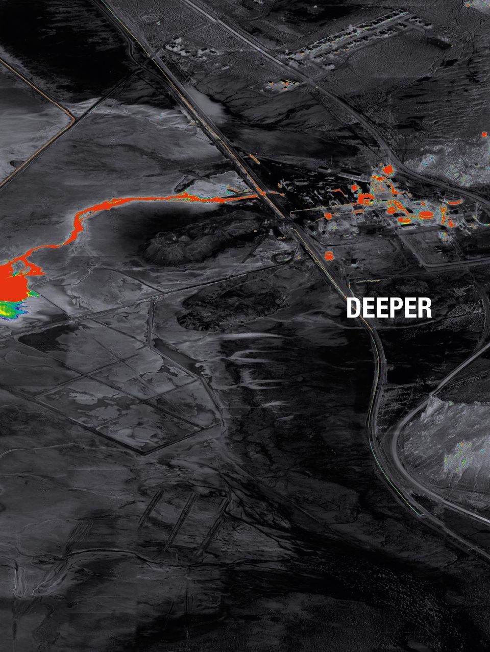
3 Data is collected today from an ever increasing number of sources ranging from simple video cameras From mounted wind farm on everything to pipe from line, people to unmanned airborne platforms, through to larger sophisticated information collection systems. rail track to forest trail, oil fi eld to corn fi eld and the archaeological to the agricultural, our toolset of SCi information management and imagery exploitation software allows you to look deeper. Simplifying Complex Information

4 TAILORING SOLUTIONS TO QUICKLY DELIVER COST-EFFECTIVE RESULTS Our toolset of SCI software easily facilitates the ingestion, processing, analysis and cataloguing of shared data, within a standalone or distributed system. Whatever your reconnaissance and intelligence requirements, we can tailor it to meet your specifi c investigative needs, creating exactly the system you need to do the job. From expansive geospatial data production to concentrated imagery analysis, we can provide an intuitive, user-friendly end-to-end solution. For multi-source data, our toolset s unique cataloguing facility affords your operator the ability to effectively gather, manage, process and utilise still and video-based imagery. Seamlessly integrating stored data with real-time exploitation for enhanced information awareness our reliable and effi cient toolset easily combines historical and up-to-the-minute reconnaissance with past intelligence analysis. The UTC Aerospace Systems suite of tools allows the customer to rapidly fi nd relevant data and disseminate to the right people at the right time. The tools allow the commander s process loop to be streamlined thereby reducing the cost of traditional methods of dissemination and shortens the process time from requirement to decision. The UTC suite of ground station tools are sensor and platform agnostic and consist of: Exploitation Management Data Ingestion Data Processing Data Cataloguing and Storage Visualisation of all stored products Data Exploitation Intelligence Production Intelligence Dissemination Information Management

5 Intelligence Exploitation and Dissemination SCi-IRL DEEPER INTELLIGENCE The SCi-IRL software allows real time ingest of multiple data types and through a user-friendly and highly intuitive web-based interface, the user is able to visualise and create links between relevant information providing them with the best situational awareness whilst reducing manpower requirements. The advanced search capability also allows the user to dig deeper into documents to fi nd the information required for them to carry out their tasks without expending additional effort. The data storage and dissemination capability of SCi-IRL provides the intelligence collection management analysts with the tools to potentially task intelligence exploitation without the need to generate specifi c missions to collect imagery. As data is added to the system, the existence of this new data is visible in SCi- IRL together with any imagery that has been collected. Where imagery or video is being ingested into the system via datalink, the analyst will see the areas of coverage in SCi-IRL as the imagery is collected in near real-time. If the analyst has noted the emergence of multiple signals intelligence reports for example in a specifi c area that may have just been imaged, the analyst is able to rapidly task additional imagery exploitation of this area of interest due to the visualisation in SCi-IRL without having to task more imagery collection which is often time consuming. Key Features STANAG 4559 Edition 3 and NATO CSD compliant server Storage of multiple data types Video cataloguing, storage, replay and live streaming Intuitive web-based map-centric search with application of data fi lter sets Auto ingest of products OGC Web Map Server (WMS) compliant SCi-X LOOKING DEEPER SCi-X is the new electronic light table for all your imagery and geo-spatial needs. It provides advanced imagery analysis tools for the operator to pull the deeper intelligence picture out of the captured imagery. Offering synchronised 3D mapping, stereo viewing, annotations and a user friendly set of geo-spatial exploitation tools, SCi-X provides a cost effective solution for deriving intelligence from multi-band imagery. SCi-X can provide military UAV operators with the ability to rapidly exploit the imagery to understand what is being imaged. If a team needed to move into a compound in a hostile area then they can fl y a UAV over the area and as the imagery is being streamed to the ground they can look for hostile forces, obstacles and escape paths. They can then exploit the imagery to create a report showing hostile locations, wall heights, path widths, the exact location and annotate further information for enhanced situational awareness and disseminate this to all involved to ensure the safety of the personnel. Key Features Still and motion imagery handling Large volume, real-time screening and exploitation of single or multi-band imagery Exploitation of multiple data Full set of mensuration, geo-location, geo-correction, annotations and symbol tools 2D and stereo viewing Tracking 3D map view with selectable overlays

6 Global support network With a comprehensive global presence, UTC Aerospace Systems is able to provide through life support for your software and hardware products to suit your requirements. Whether you need 24 hour telephone support or to have a Contractor Logistics Support representative at your designated location, we can provide the service you need. We can also provide extensive training on the software and hardware solutions we build for you provided by our expert training team either at a location of your choice or at the UTC Aerospace Systems facilities in the UK. SCi-IRL gives the user the ability to see all geographically covered areas with thumbnail previews. SCi-IRL allows the user to preview documents and images to build a better understanding of the information available. SCi-X full motion video capability provides real time cataloguing and viewing of live imagery. SCi-X gives you the ability to fi nd the answers in multiple sensor bands.

7 Our markets are diverse and challenging Civilian Uses Police imagery and information Archaeological survey Fire Monitoring Mine Survey Disaster Management Forestry Management Border Security Pipeline Inspection Game Reserve Poaching Monitoring Pylon Inspection Counter Piracy Operations Wind Turbine inspection Event Management Train Track Inspection Road inspection Cooling tower inspection Historical monument inspection Support to the Emergency Services Coastal Erosion Surveys General aerial photography Film Production Support Agriculture Monitoring and Survey Environmental Surveys Oil Pipeline Inspection Inaccessible Areas Survey Military Uses Information Situational Awareness Force Protection Intelligence Reporting Maritime Patrol Counter Piracy Operations Counter Narcotics Operations In addition to the suite of tools UTC Aerospace Systems also undertakes the following: Full systems integration with existing or planned third party sensor suites. Bespoke design of hardware footprint to meet customer requirements ranging from: Hand held tablets Laptops Transportable Ground Station (TGS) Fixed Ground Station (FGS) Mobile Ground Station (MGS) Airborne Business Jet fi t Pod mounted libraries ISR Consultancy System Concept Development Concept Of Operations (CONOP) Implementation Support Software Development Training and Simulation Development of customer training packages Full System Training for all UTC Aerospace Systems ISR products

8 WHY NOT LOOK DEEPER, TODAY ISR & Space Systems Malvern Hills Science Park, Geraldine Road, Malvern, Worcestershire, WR14 3SZ, UK Phone: +44 (0) Fax: +44 (0) UTC AEROSPACE SYSTEMS PROPRIETARY. This document does not contain any export controlled technical data. 10/2014
 1684 899700 Fax: +44 (0) 1684 899710 UTC AEROSPACE SYSTEMS")
Nighthawk IV UAS. Versatility. User Friendly Design. Capability. Aerial Surveillance Simplified. [email protected] 800.639.6315 www.ara.
 Aerial Surveillance Simplified The Nighthawk IV small unmanned aerial vehicle brings military hardened technology to civil agencies and commercial user groups. Supremely easy to operate and recently certified
Providing On-Demand Situational Awareness
 ITT Exelis Geospatial Intelligence Solutions Providing On-Demand Situational Awareness Use of U.S. Department of Defense (DoD) and U.S. Army imagery in this brochure does not constitute or imply DoD or
High-value, affordable, sustainable special missions solutions.
 SPECIAL MISSIONS High-value, affordable, sustainable special missions solutions. When government, military and commercial customers want airborne solutions for critical missions, they turn to Beechcraft.
HNOLOGY IN POLICING SECURITY & CYBERSPACE SITUATION
 S e c u r i t y & D e f e n c e Bringing The Digital Edge To Your Operations ITY & CYBERSPACE SITUATIONAL AWARENESS CRITICAL COM S CRITICAL COMMUNICATIONS TECHNOLOGY IN POLICING SE ITUATIONAL AWARENESS
UAS Insurance - a business necessity. Unmanned Aircraft Systems Typical risks and insurance issues for commercial activities.
 UAS Insurance - a business necessity Unmanned Aircraft Systems Typical risks and insurance issues for commercial activities Adam Piper ACII September 2012 Agenda Introductions Current commercial activities
AeroVironment, Inc. Unmanned Aircraft Systems Overview Background
 AeroVironment, Inc. Unmanned Aircraft Systems Overview Background AeroVironment is a technology solutions provider with a more than 40-year history of practical innovation in the fields of unmanned aircraft
Keystone Image Management System
 Image management solutions for satellite and airborne sensors Overview The Keystone Image Management System offers solutions that archive, catalogue, process and deliver digital images from a vast number
www.thalesgroup.com/watchkeeper WATCHKEEPER X UNMANNED AIRCRAFT SYSTEM (UAS)
") www.thalesgroup.com/watchkeeper WATCHKEEPER X UNMANNED AIRCRAFT SYSTEM (UAS) Certified Foundation Watchkeeper X is built to the same standards as a manned aircraft, and conforms to CAA/MAA standards. It
www.thalesgroup.com/watchkeeper WATCHKEEPER X UNMANNED AIRCRAFT SYSTEM (UAS) Certified Foundation Watchkeeper X is built to the same standards as a manned aircraft, and conforms to CAA/MAA standards. It
Government Technology Trends to Watch in 2014: Big Data
 Government Technology Trends to Watch in 2014: Big Data OVERVIEW The federal government manages a wide variety of civilian, defense and intelligence programs and services, which both produce and require
Solving Agencies Big Data Challenges: PED for On-the-Fly Decisions
 White Paper Solving Agencies Big Data Challenges: PED for On-the-Fly Decisions Carina Veksler, NetApp March 2012 WP-7158 ABSTRACT With the growing volumes of rich sensor data and imagery used today to
ERDAS IMAGINE The world s most widely-used remote sensing software package
 ERDAS IMAGINE The world s most widely-used remote sensing software package ERDAS IMAGINE Geographic imaging professionals need to process vast amounts of geospatial data every day often relying on software
The leading compliance and service delivery software in Facilities management
 The leading compliance and service delivery software in Facilities management About Innovise www.innovisesoftware.com Tried and trusted, Innovise is the leading IT partner of choice for hundreds of clients
Command Support System
 Command Support System The world s most advanced interoperable and resilient incident management system for emergency services, emergency management, security and homeland defence organisations. State
www. thalesgroup. com Network Management Systems
 www. thalesgroup. com Network Management Systems NETWORK MANAGEMENT SYSTEMS FROM THALES Based on Thales' highly successful dynamic management software, the NMS family of Link 16 products provides fully
Technology driven security
 Technology driven security The heart of our approach to security is innovation and being resilient to risk. Our priority is to work in partnership with our clients to deliver technologydriven, future-proofed
RPAS for homeland security applications. Jean CARON Mission Air Systems Lima April 2012
 RPAS for homeland security applications Jean CARON Mission Air Systems Lima April 2012 Agenda RPAS, what is it? Homeland security, what is it? RPAS for Homeland security RPAS Industry capabilities and
GEOSPATIAL DIGITAL ASSET MANAGEMENT A SOLUTION INTEGRATING IMAGERY AND GIS WHERE WILL ALL THE PIXELS GO?(AND HOW WILL WE EVER FIND THEM?
 GEOSPATIAL DIGITAL ASSET MANAGEMENT A SOLUTION INTEGRATING IMAGERY AND GIS WHERE WILL ALL THE PIXELS GO?(AND HOW WILL WE EVER FIND THEM?) Dr. Joan Lurie, GCC, Inc. 30 West 61 st Street, Apt 9A New York,
The premier software for extracting information from geospatial imagery.
 Imagery Becomes Knowledge ENVI The premier software for extracting information from geospatial imagery. ENVI Imagery Becomes Knowledge Geospatial imagery is used more and more across industries because
Introducing Carmenta Engine for Android
 Introducing Carmenta Engine for Android We are proud to be able to give Android software developers access to the tools and components they need to add map support in mission critical mobile applications.
Optimizing Energy Operations with Machine-to-Machine Communications
 Optimizing Energy Operations with Machine-to-Machine Communications Contents Executive Summary... 3 The Role of M2M in Energy Companies... 3 Leveraging a M2M Platform... 5 Key Requirements for M2M Application
Physical Security Simulation and Analysis Tools A presentation for the Canada & United States Security Simulation Technologies Group
 SAND 2014-3718P Physical Security Simulation and Analysis Tools A presentation for the Canada & United States Security Simulation Technologies Group Unclassified Unlimited Information For Public Dissemination
M2M transforms an industry: evolution of heavy equipment and dispersed assets
 M2M transforms an industry: evolution of heavy equipment and dispersed assets Whitepaper April 2013 Steve Hilton Executive summary Enterprises with heavy equipment and dispersed assets are competing in
ENVI THE PREMIER SOFTWARE FOR EXTRACTING INFORMATION FROM GEOSPATIAL IMAGERY.
 ENVI THE PREMIER SOFTWARE FOR EXTRACTING INFORMATION FROM GEOSPATIAL IMAGERY. ENVI Imagery Becomes Knowledge ENVI software uses proven scientific methods and automated processes to help you turn geospatial
Geospatial exploitation Products. GXP WebView. Powered by the GXP Platform
 Geospatial exploitation Products GXP WebView Powered by the GXP Platform Exploitation Capabilities GXP WebView Powered by the GXP Platform Detailed annotation (text, points, lines, and polygons) Distance,
Texas Develops Online Geospatial Data Repository to Support Emergency Management
 Bing Maps for Enterprise Microsoft Customer Solution Case Study Texas Develops Online Geospatial Data Repository to Support Emergency Management Overview Country or Region: United States Industry: Government
Integrated Physical Security and Incident Management
 IT Enterprise Services Integrated Physical Security and Incident Management Every organisation needs to be confident about its physical security and its ability to respond to unexpected incidents. Protecting
Mobius TM Command & Control Software
 Mobius TM Command & Control Software Mobius TM is a user-friendly software solution used to command, control, and monitor multiple unmanned systems. In addition to its powerful confi gurable GUI, Mobius
_ LUCIADMOBILE V2015 PRODUCT DATA SHEET _ LUCIADMOBILE PRODUCT DATA SHEET
 _ LUCIADMOBILE PRODUCT DATA SHEET V2015 LuciadMobile enables the rapid development of geospatial situational awareness applications on mobile devices running Android, and is specifically designed for situational
Video Architectures Eyes on the Future: The Benefits of Wireless Technology for Fixed Video Surveillance
 S O L U T I O N PA P E R Video Architectures Eyes on the Future: The Benefits of Wireless Technology for Fixed Video Surveillance Table of Contents Fixed Video Surveillance: The Big Three... 3 Wireless
Secure Ports Solutions
 Solutions Grupo Revenga is a leading provider of telecommunications and information technology solutions, electronic security and energy efficiency. The company offers comprehensive end-to-end solutions
CenterMind G+ Smart and Proactive Environment Monitoring
 CenterMind G+ Smart and Proactive Environment Monitoring Smart and Proactive Environment Monitoring real-time visibility into the state of your computer room or data center environment, 24/7 RiT CenterMind
CORPORATE PRESENTATION December 2015
 CORPORATE PRESENTATION December 2015 FORWARD LOOKING STATEMENT Certain information and statements in this presentation constitute forward-looking statements. Words such as forecast, project, intend, expect,
Processing, Cataloguing and Distribution of UAS Images in Near-Real-Time. Andreas Kühnen GEOSYSTEMS
 Processing, Cataloguing and Distribution of UAS Images in Near-Real-Time Andreas Kühnen GEOSYSTEMS Copyright GEOSYSTEMS GmbH 2013. Irrtum und Änderungen vorbehalten. R&D project of German Army System zur
www.ryansolutions.eu BUSINESS SECURITY SOLUTION FOR CHAIN GAS STATIONS
 BUSINESS SECURITY SOLUTION FOR CHAIN GAS STATIONS BUSINESS SECURITY SYSTEM SOVA BUSINESS SECURITY SYSTEM SOVA is designed to create a single information field for safety management within a large enterprise.
A Division of Allied International Support. An Overview. Profile Of Capability. www.aissecuritysolutions.com. an Effective Security Shield
 A Division of Allied International Support An Overview Profile Of Capability AIS International A GCC Defense Solutions company, in business for 10 yrs. AIS Oman - Ruwi A division of Allied International
T a c k l i ng Big Data w i th High-Performance
 Worldwide Headquarters: 211 North Union Street, Suite 105, Alexandria, VA 22314, USA P.571.296.8060 F.508.988.7881 www.idc-gi.com T a c k l i ng Big Data w i th High-Performance Computing W H I T E P A
Simulation and Training Solutions
 Simulation and Training Solutions Strong Learning Experiences Available Nowhere Else Advancing Operational Readiness with Leading-Edge Simulation and Training The rapid evolution of military missions,
Aerosonde UAS: A Game Changer in Oil and Gas Security Jack Kormas Director of Operations, Aerosonde Pty Ltd 24 February 2015
 Aerosonde UAS: A Game Changer in Oil and Gas Security Jack Kormas Director of Operations, Aerosonde Pty Ltd 24 February 2015 1 extron Inc. Leading Businesses Bell extron Aviation extron Systems Industrial
IAI/Malat Solutions for the Maritime Arena
 IAI/Malat Solutions for the Maritime Arena Any country with a proximity to the sea has an important operational need to positively and unambiguously identify, in time, threats that originate in the maritime
Satellite-Based Earth Observation (EO), 7th Edition
, 7th Edition") Satellite-Based Earth Observation (EO), 7th Edition Report Brief www.nsr.com 2013 NSR Report Description NSR s Satellite-Based Earth Observation (EO), 7th Edition is the industry-leading analysis of the
Satellite-Based Earth Observation (EO), 7th Edition Report Brief www.nsr.com 2013 NSR Report Description NSR s Satellite-Based Earth Observation (EO), 7th Edition is the industry-leading analysis of the
How to do it Manual No. 3: ArcMap10 in Remote Desktop mode and Landgate slip files. Jeremy Green
 How to do it Manual No. 3: ArcMap10 in Remote Desktop mode and Landgate slip files Jeremy Green Report Department of Maritime Archaeology No. 268 2010 Getting started with ArcInfo10 The ArcInfo10 exists
Appendix J Online Questionnaire
 Appendix J Online Questionnaire In accordance with the Paperwork Reduction Act, this questionnaire was approved by the Office of Management and Budget (OMB). The OMB control number and expiration date
How To Use Inmarsat M2M On A Sim Card
 One global 3G network. One global SIM. In today s always-on business environment can you afford to be in the dark? The use of machine-to-machine (M2M) technology is growing fast - and no wonder. The idea
Physical Security Information Management Software - Concepts - Solutions
 Physical Security Information Management Software - Concepts - Solutions A system is only as secure as its weakest link Technical Management Security Information Management ViPRO.solutions Communications
CONSTANTINE CONSTANTINE. Fine art logistics for private collectors, museums and galleries
 BY APPOINTMENT TO HER MAJESTY THE QUEEN FINE ART PACKING, HANDLING, TRANSPORTATION AND STORAGE SERVICES LIMITED, LONDON BY APPOINTMENT TO HER MAJESTY THE QUEEN FINE ART PACKING, HANDLING, TRANSPORTATION
UAS Training Solutions
 UAS Training Solutions UAS Training Solutions Training and operational support for mission readiness The use of unmanned aerial systems (UAS) by defence and security forces globally has grown over the
Boosting Business Agility through Software-defined Networking
 Executive Summary: Boosting Business Agility through Software-defined Networking Completing the last mile of virtualization Introduction Businesses have gained significant value from virtualizing server
GXP WebView GEOSPATIAL EXPLOITATION PRODUCTS (GXP )
") GEOSPATIAL EXPLOITATION PRODUCTS (GXP ) GXP WebView A Web-based, full-resolution image viewing tool for visualization, annotation, measurement, and publishing providing access to remote data from any location.
GEOSPATIAL EXPLOITATION PRODUCTS (GXP ) GXP WebView A Web-based, full-resolution image viewing tool for visualization, annotation, measurement, and publishing providing access to remote data from any location.
Any Threat, Anywhere, Anytime. ddn.com. DDN Whitepaper. Scalable Infrastructure to Enable the Warfighter
 DDN Whitepaper Any Threat, Anywhere, Anytime Scalable Infrastructure to Enable the Warfighter Table of Contents The Big Data Challenge and Opportunity 3 Challenges with Traditional Storage 4 Why DataDirect
End-to-end Field Service Management
 End-to-end Field Service Management Building end-to-end field service management solutions around your unique business processes Customer Self-Service Service Desk Software Workforce Scheduling Mobile
Remote Management White Paper 27th June, 2012
 Remote Management White Paper 27th June, 2012 Contents Page 3 Page 4 Page 5 Page 8 Page 10 Page 11 Executive Summary The rise of wireless M2M The need Remote monitoring and control Borderless networks
VIDEO MONITORING & ALARM VERIFICATION NASKAM SECURITY SERVICES PTY LTD
 VIDEO MONITORING & ALARM VERIFICATION VIDEO MONITORING What is Video Monitoring Video or CCTV Monitoring as a service has been around for many years particularly in the Mining and Access Control Industries
W H I T E P A P E R. Security & Defense Solutions Intelligent Convergence with EdgeFrontier
 W H I T E P A P E R Security & Defense Solutions Intelligent Convergence with EdgeFrontier Contents 1. Introduction... 2 2. The Need for Intelligent Convergence... 3 2.1 Security Convergence with EdgeFrontier...
The Value of Managing Global Transportation from a Single Platform
 The Value of Managing Global Transportation from a Single Platform Introduction Globalization has put new pressures on shippers to carefully coordinate and orchestrate the movement of goods and merchandise
The needs on big data management for Operational Geo-Info Services: Emergency Response, Maritime surveillance, Agriculture Management
 Copernicus Big-Data Workshop 2014, 13/14 March The needs on big data management for Operational Geo-Info Services: Emergency Response, Maritime surveillance, Agriculture Management Marco Corsi e-geos 1
The following was presented at DMT 14 (June 1-4, 2014, Newark, DE).
.") DMT 2014 The following was presented at DMT 14 (June 1-4, 2014, Newark, DE). The contents are provisional and will be superseded by a paper in the DMT 14 Proceedings. See also presentations and Proceedings
DMT 2014 The following was presented at DMT 14 (June 1-4, 2014, Newark, DE). The contents are provisional and will be superseded by a paper in the DMT 14 Proceedings. See also presentations and Proceedings
Comprehensive European Security Approaches: EU Security Programmes. Robert HAVAS EOS Chairman of the Board
 Comprehensive European Security Approaches: EU Security Programmes Robert HAVAS EOS Chairman of the Board INTRODUCTION the EOS Programmes rationale Why implementing EU Security Programmes / ASPIDA approach?
Innovation. Performance. Security. SMARTSCAN man-portable land EW solutions. target. up-to-the-minute situational intelligence
 Innovation. Performance. Security SMARTSCAN man-portable land EW solutions target up-to-the-minute situational intelligence The increasing demands of Electronic Warfare As the digital era takes hold, the
CHAPTER 1 INTRODUCTION
 CHAPTER 1 INTRODUCTION 1.1 Background of the Research Agile and precise maneuverability of helicopters makes them useful for many critical tasks ranging from rescue and law enforcement task to inspection
ENABLING HIGH PERFORMANCE GEOSPATIAL APPLICATIONS IN THE CLOUD _ WHITE PAPER
 ENABLING HIGH PERFORMANCE GEOSPATIAL APPLICATIONS IN THE CLOUD _ WHITE PAPER CONTENTS I. INTRODUCTION 3 II. CHALLENGES OF DEPLOYING HIGH PERFORMANCE GEOSPATIAL CAPABILITIES IN THE CLOUD 3 A. Challenges
Coordinated Operation Capability Using Scalable C2
 Coordinated Operation Capability Using Scalable C2 Authors: Hüseyin KUTLUCA, İbrahim AKSU, Arda ÜNAL MilSOFT Yazılım Teknolojileri A.Ş. Teknokent, 06800 ODTU Ankara / TURKEY [email protected] [email protected]
Shallow Water Swath Bathymetry from Small Platforms. Advances in Seafloor Mapping Sonar, 30 Dec 2009 Systems Engineering & Assessment Ltd.
 Shallow Water Swath Bathymetry from Small Platforms Advances in Seafloor Mapping Sonar, 30 Dec 2009 Systems Engineering & Assessment Ltd. Presentation Requirements, applications and challenges SWATHplus
Graphical Processing Units to Accelerate Orthorectification, Atmospheric Correction and Transformations for Big Data
 Graphical Processing Units to Accelerate Orthorectification, Atmospheric Correction and Transformations for Big Data Amanda O Connor, Bryan Justice, and A. Thomas Harris IN52A. Big Data in the Geosciences:
Advanced Network Video And Alarm Management Suite
 Advanced Network Video And Alarm Management Suite ViMS. Advanced Network Video & Alarm Management Suite G anz ViMS Command is a powerful IP network based, open standards Video & Alarm Management software
Current Challenges in UAS Research Intelligent Navigation and Sense & Avoid
 Current Challenges in UAS Research Intelligent Navigation and Sense & Avoid Joerg Dittrich Institute of Flight Systems Department of Unmanned Aircraft UAS Research at the German Aerospace Center, Braunschweig
Nomi 05.14.14 Door Counting Primer V.001 1. Door Counting: An Essential for Customer Experience Measurement and Management
 Nomi 05.14.14 Door Counting Primer V.001 1 Door Counting: An Essential for Customer Experience Measurement and Management Nomi 05.14.14 Door Counting Primer V.001 2 If you can t measure it, you can t manage
Industrial Internet @GE. Dr. Stefan Bungart
 Industrial Internet @GE Dr. Stefan Bungart The vision is clear The real opportunity for change surpassing the magnitude of the consumer Internet is the Industrial Internet, an open, global network that
Satellite Solutions for Emergency Relief and Disaster Recovery Management. May 2009
 Satellite Solutions for Emergency Relief and Disaster Recovery Management May 2009 Introduction Disasters can occur anytime and anywhere. Whether the emergency is an act of nature or an act of man, the
Delivering peace of mind in outsourcing
 > Delivering peace of mind in outsourcing How to increase enterprise performance when outsourcing mission critical systems www.thalesgroup.com/security-services AND >> PERFORMANCE OUTSOURCING OF MISSION
Hotel TV. Made Smart.
 quadriga.com/smartqubetv Television & Mobile Internet & Networks Multi Media & Content Professional Services 2 Get more from your TV. Smart is upgrading your TVs without replacing them, or spending less
BSc (Hons) in Geomatics (Surveying & Mapping) DT112
 in Geomatics (Surveying & Mapping) DT112") School of Spatial Planning DEPARTMENT OF SPATIAL INFORMATION SCIENCES BSc (Hons) in Geomatics (Surveying & Mapping) How Sat-Nav systems work? December 2011 geekanoids.co.uk Imagery by baboom.ie How the
School of Spatial Planning DEPARTMENT OF SPATIAL INFORMATION SCIENCES BSc (Hons) in Geomatics (Surveying & Mapping) How Sat-Nav systems work? December 2011 geekanoids.co.uk Imagery by baboom.ie How the
BSc (Hons) in Geomatics (Surveying & Mapping) DT112
 in Geomatics (Surveying & Mapping) DT112") School of Spatial Planning DEPARTMENT OF SPATIAL INFORMATION SCIENCES BSc (Hons) in Geomatics (Surveying & Mapping) December 2011 HAVE YOU EVER WONDERED? How Sat-Nav systems work? geekanoids.co.uk Imagery
School of Spatial Planning DEPARTMENT OF SPATIAL INFORMATION SCIENCES BSc (Hons) in Geomatics (Surveying & Mapping) December 2011 HAVE YOU EVER WONDERED? How Sat-Nav systems work? geekanoids.co.uk Imagery
Air Traffic Management Solutions
 Air Traffic Management Solutions Exelis Air Traffic Management Solutions For over 70 years, Exelis has been a trusted provider of mission critical products, solutions, and services that support civil air
GNSS Anti-Jam Technology for the Mass Market
 GNSS Anti-Jam Technology for the Mass Market Michael Jones, Senior Consultant Engineer, GNSS Protection Roke Manor Research Ltd Communications Sensors Information Systems Contract R&D Consultancy Specialist
Application of cloud based sensor data infrastructure for agricultural information service in Hokkaido Japan
 Application of cloud based sensor data infrastructure for agricultural information service in Hokkaido Japan APAN 36th Meeting 20 Aug 2014 HONDA Kiyoshi: Chubu University Apichon Witayangkurn: University
Omnis. tracking technology. tamed protecting freight, safeguarding profits
 Omnis tracking technology tamed protecting freight, safeguarding profits 2 Our vision: to make freight more efficient The massive increase in transportation of goods and freight forwarding has inevitably
Leveraging Network Infrastructure to Bring Critical Information to Users
 Leveraging Network Infrastructure to Bring Critical Information to Users 13 May 2013 Brian Slaughter Director, Global Public Safety Sales General Dynamics C4 Systems 2013 General Dynamics. All rights reserved.
InfraStruxure Data Centre Management Software. Holistic open standards integrated data centre management solution.
 Data Centre Solutions...energy efficient by design InfraStruxure Data Centre Management Software Holistic open standards integrated data centre management solution. Creating an effective workspace environment
CTX OVERVIEW. Ucentrik CTX
 CTX FACT SHEET CTX OVERVIEW CTX SDK API enables Independent Developers, VAR s & Systems Integrators and Enterprise Developer Teams to freely and openly integrate real-time audio, video and collaboration
Cognizant Mobile Risk Assessment Solution
 Cognizant Solutions Overview Solution Overview Cognizant Mobile Risk Assessment Solution 1 Mobile Risk Assessment Solution Overview Cognizant Solutions Overview Transforming Risk Engineering, Field Underwriting
mobile connect mobileconnect A complete software, hardware and managed service solution for mobile workers
 Do you want to: Deploy a wide range of applications quickly and easily? Streamline your processes and optimise the efficiency of your workers? Save time and money whilst boosting productivity? If so, the
Practical Enterprise Mobility
 Practical Enterprise Mobility Authored by Sponsored by Introduction In the traditional IT model of a few years ago, when the employees of a company needed to access an enterprise application or business
Working Smarter & Working Faster. How Mobile Workforce Management Solutions Are Changing the Game for SMBs
 Working Smarter & Working Faster How Mobile Workforce Management Solutions Are Changing the Game for SMBs Contents Introduction...3 Better Visibility, Better Collaboration...4 Ever-Improving Service...5
INDUSTRY SECTOR EXPERTISE CUSTOMER CENTRIC. SEKO Logistics Global Supply Chain Solutions
 INDUSTRY SECTOR EXPERTISE CUSTOMER CENTRIC SEKO Logistics Global Supply Chain Solutions We provide a suite of logistics services which enable you to use your supply chain as a competitive differentiator.
A new approach to rail asset management.
 A new approach to rail asset management. Geotechnical and structural monitoring via satellite for the rail industry. With mounting pressures on the UK s ageing infrastructure networks from ever increasing
Future J-ISR. Big Data Processing. CASD Roma 10 Ottobre 2013. Filippo Gemma - GMSPAZIO
 CASD Roma 10 Ottobre 2013 Big Data Processing Filippo Gemma - GMSPAZIO NATO's Joint Intelligence, Surveillance and Reconnaissance Concept (JISR) UV12 Joint Intelligence, Surveillance and Reconnaissance
Implementing an Imagery Management System at Mexican Navy
 Implementing an Imagery Management System at Mexican Navy The Mexican Navy safeguards 11,000 kilometers of Mexican coastlines, inland water bodies suitable for navigation, and the territorial sea and maritime
3D City Models for Simulation & Training Requirements on Next Generation 3D City Models
 3D City Models for Simulation & Training Requirements on Next Generation 3D City Models Frank Bildstein Rheinmetall Defence Electronics Rheinmetall Defence Electronics GmbH, Bremen, 07/2005 Contents Applications
INTELLIGENCE AND HOMELAND DEFENSE INSIGHT
 I N D U S T R Y INTELLIGENCE AND HOMELAND DEFENSE INSIGHT INTELLIGENCE AND HOMELAND DEFENSE CHALLENGES The Intelligence Community (IC) needs the right information, in real time, to make critical decisions.
What s new in Carmenta Server 4.2
 What s new in Carmenta Server 4.2 A complete solution for cost-effective visualisation and distribution of GIS data through web services Carmenta Server provides cost-effective technology for building