Geographic Learning in Social Web Environments
|
|
|
- Horatio Marshall
- 10 years ago
- Views:
Transcription
1 Geographic Learning in Social Web Environments Josef Strobl UNIGIS Distance Learning Programme Centre for Geoinformatics Salzburg University, Austria

2 2 / 40
3 Keywords Web 2.0 Social Web Real World vs. Virtual Worlds Active / Constructivist Learning Real-time Geography Virtual and Imaginary Worlds 3 / 40

4 (e)learning... as a Social Activity emphasis: different perspectives on elearning Development towards the Social Web and Semantic Web Hoschka (1998); Reed et al (2004) elearning 2.0 (Downes, 2005) 4 / 40
; Reed")
5 Social Web / Web 2.0 Wikis Blogs Networking via: Xing, LinkedIn, Virtual Worlds Second Life Social Web enabling of Virtual Globes (Worldwind, GE, MS VE local live, ArcGIS Explorer ) 5 / 40

6 Web 1.0 > 2.0 From linking documents towards linking people, generating ideas, 6 / 40

7 elearning LMS as distribution platforms for media and hubs for communication evolve towards Environments where concepts and ideas are understood / created / discussed 7 / 40

8 Communities of Practice are formed by people who engage in a process of collective learning in a shared domain of human endeavor: a tribe learning to survive, a band of artists seeking new forms of expression, a group of engineers working on similar problems, a clique of pupils defining their identity in the school, a network of surgeons exploring novel techniques, a gathering of firsttime managers helping each other cope. In a nutshell: Communities of practice are groups of people who share a concern or a passion for something they do and learn how to do it better as they interact regularly. (Wenger et al, 2002). 8 / 40

9 Is there any particular Geographic perspective? 9 / 40

10 Real < > Virtual Worlds > Connecting through Location < 10 / 40

11 Geographic Information and Web 2.0 Simple Georeferencing combined with spatial indexing / search Virtual Field Trips Wikis linked to VG s, map services Blogs and GeoRSS GeoFencing Social Networking in real life Virtual / Imaginary Worlds 11 / 40

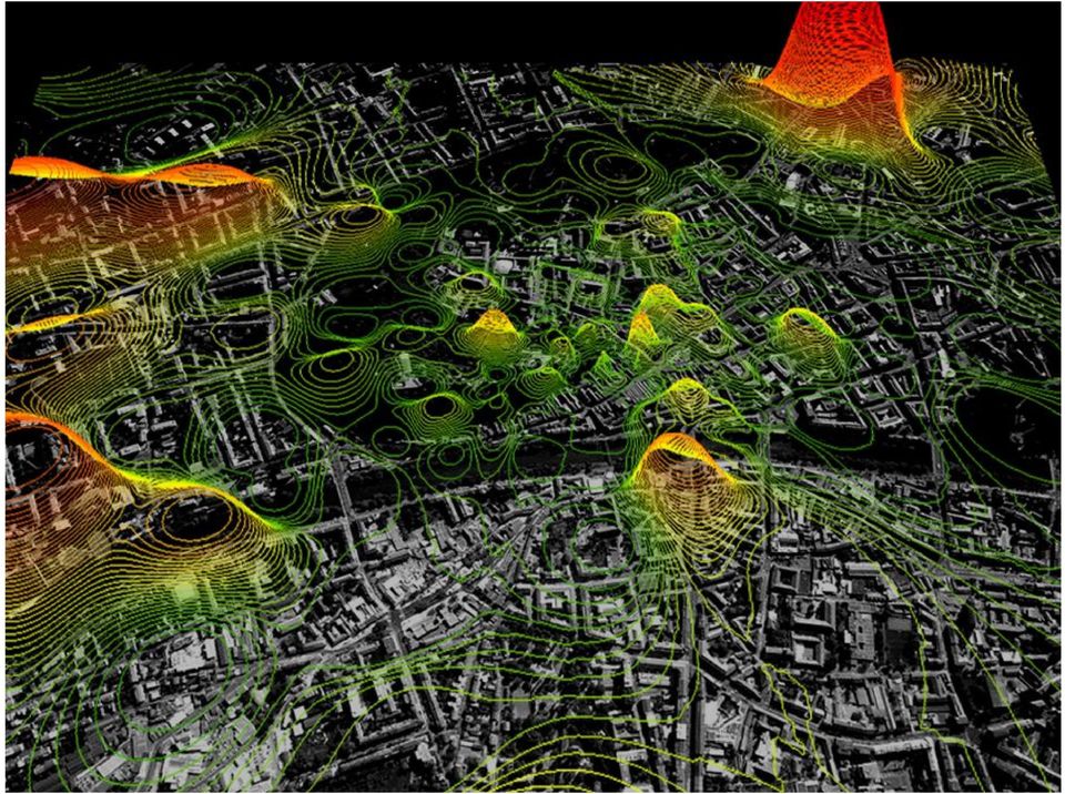
12 Realtime Geographies Live connectivity enables realtime Example: cellphone localisation 12 / 40

13 13 / 40
14 City Hot Spots Outbreak (405) Airport (7) CountyBoundary (1) Highw ays (3,660) Parks (17) Streets (22,682) Agricultural Land Use (86) Total Results (1) Railroads (598) 14 / 40
 Total Results (1) Railroads (598) 14 /")
15 Beyond Learning Public Participation Community planning, environment, Virtual <> F2F Interaction Buddy lists, Hotspots etc New Orientation / Navigation Linking mental maps and real world 15 / 40

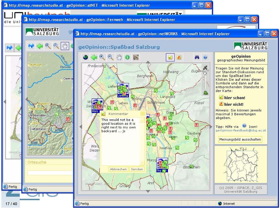
16 Public Participation Based in Internet Access Spatial Opinion Poll Make spatial decision finding transparent and accessible Create an opinion map Feed into policy / decision making 16 / 40

17 17 / 40
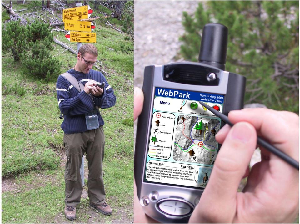
18 Prerequisite: Pervasive Positioning Telecom Based GPS 24 satellites broadcasting fixed position Wi-Fi Smart Tags 18 / 40

19 Client complexity increases Client standardization decreases Network requirements decrease Storage capacity decreases Server complexity decreases Client complexity decreases Client standardization increases Network requirements increase Storage capacity increases Server complexity increases Visualization Visualization Visualization Visualization Client Geographic Analysis Geographic Analysis Geographic Analysis Alphanumeric Analysis Alphanumeric Analysis Geographic Analysis Data Management Alphanumeric Analysis Alphanumeric Analysis Server Data Management Data Management Data Management 19 / 40

20 20 / 40
21 21 / 40
22 Immersive Environments 22 / 40
23 Virtual Globes 23 / 40
24 24 / 40
25 Second Life 25 / 40
26 GISociety GISociety Education Business Technology Enabled Aware Literate Spatially 26 / 40
27 27 / 40
What are communities of practice?
 Communiitiies of practiice a briieff iinttroducttiion Etienne Wenger The term "community of practice" is of relatively recent coinage, even though the phenomenon it refers to is age-old. The concept has
GEO-SPATIAL-TECHNOLOGIES", a trans-university new integrative master degree
 GEO-SPATIAL-TECHNOLOGIES", a trans-university new integrative master degree Wolfgang Sulzer Institute for Geography and Regional Science University of Graz, Austria Heinrichstrasse 36 A-8010 Graz, Austria
Sample Pages. Free E-mail Newsletter Sign up Today! Learn Through Experience
 Learn Through Experience Sample Pages Sample pages from this product are provided for evaluation purposes. The entire product is available for purchase at www.socialstudies.com or www.teachinteract.com
Student Tracking & Auto Relay Systems (STARS) Integrating student and transportation asset tracking with intelligent Geographic Information Systems
 Integrating student and transportation asset tracking with intelligent Geographic Information Systems") Student Tracking & Auto Relay Systems (STARS) Integrating student and transportation asset tracking with intelligent Geographic Information Systems Knowing where our children are empowers us to ensure
Student Tracking & Auto Relay Systems (STARS) Integrating student and transportation asset tracking with intelligent Geographic Information Systems Knowing where our children are empowers us to ensure
GIS for Transportation Infrastructure Management
 GIS for Transportation Infrastructure GIS for Transportation Infrastructure Being able to visualize your assets and the surrounding environment when you build, upgrade, or repair transportation infrastructure
DIABLO VALLEY COLLEGE CATALOG 2015-2016
 GEOGRAPHY GEOG Tish Young, Dean Physical Sciences and Engineering Division Physical Sciences Building, Room 263 Possible career opportunities Geography is an interdisciplinary study focusing on the spatial
How To Map Human Dynamics With Social Media For Disaster Alerts
 Mapping Human Dynamics with Social Media for Disaster Alerts Dr. Ming-Hsiang Tsou [email protected] Professor of Geography, Director of the Center for Human Dynamics in the Mobile Age, San Diego State
Free Google Tools for Creating Interactive Mapping Mashups
 Free Google Tools for Creating Interactive Mapping Mashups Cary Chadwick Emily Wilson Tuesday, May 10, 2011 2pm Welcome to the CLEAR Webinar Series! This is the fourth in the 2011 series Riparian Corridors,
KEY WORDS: Geoinformatics, Geoinformation technique, Remote Sensing, Information technique, Curriculum, Surveyor.
 CURRICULUM OF GEOINFORMATICS INTEGRATION OF REMOTE SENSING AND GEOGRAPHICAL INFORMATION TECHNOLOGY Kirsi VIRRANTAUS*, Henrik HAGGRÉN** Helsinki University of Technology, Finland Department of Surveying
Quick Start Guide to. ArcGISSM. Online
 Quick Start Guide to ArcGISSM Online ArcGIS Online Quick Start Guide ArcGIS SM Online is a cloud-based mapping platform for organizations. Users get access to dynamic, authoritative content to create,
A GIS helps you answer questions and solve problems by looking at your data in a way that is quickly understood and easily shared.
 A Geographic Information System (GIS) integrates hardware, software, and data for capturing, managing, analyzing, and displaying all forms of geographically referenced information. GIS allows us to view,
Sustainable Development for Smart Cities: A Geospatial Approach
 Middle East Geospatial Forum Dubai 16 th February 2015 Sustainable Development for Smart Cities: A Geospatial Approach Richard Budden Business Development Manager, Transportation and Infrastructure [email protected],
GIS Web Based Application in Crime Monitoring in Malaysia
 Safe City Monitoring System GIS Web Based Application in Crime Monitoring in Malaysia Geospatial World Forum 2014 Geneva, Switzerland 5-9 M ay 2014 SIOW SUAN NEO Safe City Programme Unit Town and Country
Esri s Telecommunications Solutions. GIS for Telecom
 Esri s Telecommunications Solutions GIS for Telecom Enterprise GIS for Telecommunications Telecommunications companies face enormous pressure to grow revenues. Triple and quad play services are creating
The Next Generation Learning Management System
 January 2013 The Next Generation Learning Management System By Rupa Shankar, Nihar Routray Happiest Minds, Social Computing Practice Copyright Information This document is the exclusive property of Happiest
THE MOST INNOVATIVE BRAND & VALUE PROTECTION SOLUTION SECURE
 THE MOST INNOVATIVE BRAND & VALUE PROTECTION SOLUTION SECURE SIMPLE SMART www.authenticvision.com SOLUTION OVERVIEW Tag Product Scan Label Authenticate Communicate Dear John Smith Authentic MEDIA UYflGMPB
Developing Fleet and Asset Tracking Solutions with Web Maps
 Developing Fleet and Asset Tracking Solutions with Web Maps Introduction Many organizations have mobile field staff that perform business processes away from the office which include sales, service, maintenance,
DIABLO VALLEY COLLEGE CATALOG 2016-2017
 Geography GEOGRAPHY GEOG Tish Young, Dean Physical Sciences and Engineering Division Physical Sciences Building, Room 263 Possible career opportunities Geography is an interdisciplinary study focusing
INDIVIDUAL COURSE DETAILS
 INDIVIDUAL COURSE DETAILS A. Name of Institution NATIONAL INSTITUTE OF TECHNICAL TEACHERS TRAINING AND RESEARCH TARAMANI CHENNAI 600 113 [An Autonomous Institute under Ministry of Human Resource Development,
Keeping track the easy way. GPS Real-Time Tracking Asset Monitoring Control of Mobile Objects
 GPS Fleet Software Keeping track the easy way GPS Real-Time Tracking Asset Monitoring Control of Mobile Objects Keeping track in a changing world Quality, speed and ongoing cost cutting are vital success
Off The Shelf Approach to ArcGIS Server & The Dashboard Approach to Gaining Insight to ArcGIS Server
 Off The Shelf Approach to ArcGIS Server & The Dashboard Approach to Gaining Insight to ArcGIS Server Robert Lenarcic Latitude Geographics [email protected] AGENDA Out of the box ArcGIS Server web-mapping
Project Management System Services
 Project Management System Services Today's projects need to deal with increasing amounts of information that require better tools to help navigate through all the data produced by projects. Our services
INTRODUCTION TO THE WEB
 INTRODUCTION TO THE WEB A beginner s guide to understanding and using the web 3 September 2013 Version 1.2 Contents Contents 2 Introduction 3 Skill Level 3 Terminology 3 Video Tutorials 3 How Does the
Internet Infrastructure
 The internet Background Created in 1969, connected computers at UCLA, Stanford Research Institute, U. of Utah, and UC at Santa Barbara With an estimated 200 million nodes and 1 billion users, the Internet
Texas Develops Online Geospatial Data Repository to Support Emergency Management
 Bing Maps for Enterprise Microsoft Customer Solution Case Study Texas Develops Online Geospatial Data Repository to Support Emergency Management Overview Country or Region: United States Industry: Government
Mapping Mashup/Data Integration Development Resources Teaching with Google Earth and Google Ocean Stone Lab August 13, 2010
 Mapping Mashup/Data Integration Development Resources Teaching with Google Earth and Google Ocean Stone Lab August 13, 2010 David Hart GIS Specialist University of Wisconsin Sea Grant Institute Virtual
Advanced Image Management using the Mosaic Dataset
 Esri International User Conference San Diego, California Technical Workshops July 25, 2012 Advanced Image Management using the Mosaic Dataset Vinay Viswambharan, Mike Muller Agenda ArcGIS Image Management
INFORMATION SCIENCE. INFSCI 0010 INTRODUCTION TO INFORMATION SCIENCE 3 cr. INFSCI 0015 DATA STRUCTURES AND PROGRAMMING TECHNIQUES 3 cr.
 INFORMATION SCIENCE INFSCI 0010 INTRODUCTION TO INFORMATION SCIENCE 3 cr. Introduction to the concepts, principles, and skills of information science for students with no programming experience. Topics
Real Time Tracking with DNRGPS
 Real Time Tracking with DNRGPS Abstract This guide explains how to use Real Time tracking features in DNRGPS. You can use this feature to display your current position in ArcMap 10.0 (not yet fully functional
GPSintegrated - GPS Tracking Platform
 GPSintegrated - GPS Tracking Platform Cloud based GPS Tracking platform used in over 25 countries for real-time tracking of People, Cars, Fleet & Assets using GPS trackers & Mobile Apps. We are your one
Trace Desktop Workforce / Fleet Management System
 Trace Desktop Workforce / Fleet Management System Introduction TRACE is an extension of SD s Geographical Information System (SPACE) which incorporates a range of GPS tracking devices that enable users
Where is... How do I get to...
 Big Data, Fast Data, Spatial Data Making Sense of Location Data in a Smart City Hans Viehmann Product Manager EMEA ORACLE Corporation August 19, 2015 Copyright 2014, Oracle and/or its affiliates. All rights
Overview of Website Analytics. membership, marketing & website solutions
 Overview of Website Analytics Part 1 Website Analytics Basics Web Analytics Defined Types of Web Analytics Which type should your chamber use? What is Web Analytics? Web Analytics is the measurement, collection,
Web and Mobile GIS Applications Development
 Web and Mobile GIS Applications Development Presented by : Aamir Ali Manager Section Head (GIS Software Customization) Pakistan Space and Upper Atmosphere Research Commission (SUPARCO) Geographical Information
Data Visualization Techniques and Practices Introduction to GIS Technology
 Data Visualization Techniques and Practices Introduction to GIS Technology Michael Greene Advanced Analytics & Modeling, Deloitte Consulting LLP March 16 th, 2010 Antitrust Notice The Casualty Actuarial
A Workflow for Creating and Sharing Maps
 A Workflow for Creating and Sharing Maps By Keith Mann, Esri What You Will Need Item Source ArcGIS Online for Organizations subscription ArcGIS 10.1 for Desktop (Any license level) ArcGIS Spatial Analyst
The Use of Geographic Information Systems in Risk Assessment
 The Use of Geographic Information Systems in Risk Assessment With Specific Focus on the RiVAMP Methodology Presented by Nadine Brown August 27, 2012 Climate Studies Group Mona Climate Change Workshop Presentation
Data Fusion Centers. Transforming Public Safety Information into Actionable Knowledge
 Data Fusion Centers Transforming Public Safety Information into Actionable Knowledge Defining Geospatial Data Fusion Homeland security relies on fusion the ability to capture and analyze data from multiple
Using ArcGIS for ios with Data on ArcGIS Online
 Using ArcGIS for ios with Data on ArcGIS Online Article ID : TT100038 Software : ArcGIS for ios, ArcGIS.com Platform : Windows XP, Windows Vista, Windows 7 Date : 1 st July, 2011 Introduction This Smart
Activity: Using ArcGIS Explorer
 Activity: Using ArcGIS Explorer Requirements You must have ArcGIS Explorer for this activity. Preparation: Download ArcGIS Explorer. The link below will bring you to the ESRI ArcGIS Explorer download page.
Zorba Asset Tracking Solution
 Asset Tracking Solution State-of-the art fleet management and vehicle tracking solution to increase your productivity. Affordable installation and operating costs Easy to install and operate User friendly
How will the convergence of LOCATION
 How will the convergence of LOCATION TECHNOLOGIES such as RFID, GPS, RTLS, and LBS AFFECT BUSINESS? By David H. Williams and Gary Hartwig How do manufacturers and diseach vehicle as it unloads with tributors

Program Learning Objectives
 Geographic Information Science, M.S. Majors in Computational Geosciences. 2012-201. Awase Khirni Syed 1 *, Bisheng Yang 2, Eliseo Climentini * 1 [email protected], Assitant Professor, Taif University,
WHAT IS GEO-FENCING? (415) 580-7936 I www.brownpelicangroup.com I [email protected]
 580-7936 I www.brownpelicangroup.com I info@brownpelicangroup.com") WHAT IS GEO-FENCING? Brown Pelican Group, a leading event Wi-Fi and technology company, in partnership with Experi-Tech, experts in cutting edge interactive tech for events, tradeshows, mobile tours, and
WHAT IS GEO-FENCING? Brown Pelican Group, a leading event Wi-Fi and technology company, in partnership with Experi-Tech, experts in cutting edge interactive tech for events, tradeshows, mobile tours, and
ACTIVITY & LOCATION BASED ANALYTICS APPLICATIONS
 ACTIVITY & LOCATION BASED ANALYTICS APPLICATIONS SEAMLESS, REAL TIME MERGING OF GIS AND ERP SYSTEMS ALLOWING THE VISUALIZATION OF RELATIONSHIPS, CONNECTIONS AND PATTERNS IN THE DATA FOR INTELLIGENT, INFORMED
Enterprise 2.0 and SharePoint 2010
 Enterprise 2.0 and SharePoint 2010 Doculabs has many clients that are investigating their options for deploying Enterprise 2.0 or social computing capabilities for their organizations. From a technology
Web Developer's Status Report. Laurie Laforest, Ph.D. Academic Technology 22 May 2009
 Web Developer's Status Report Laurie Laforest, Ph.D. Academic Technology 22 May 2009 Overview Move to Concordia template Staff training on Contribute software IITS Projects Google audit of sites in Concordia
Visitor management strategy
 Visitor management strategy Introduction Protected areas attract people. Sometimes the protected area management is glad about people who are interested in their work and activities, sometimes protected
Geographical Information Technology (GIT) courses @ Stellenbosch University. Prof Adriaan van Niekerk
 courses @ Stellenbosch University. Prof Adriaan van Niekerk") Geographical Information Technology (GIT) courses @ Stellenbosch University Prof Adriaan van Niekerk Stellenbosch Outline Overview of GIT training @ SU Programmes Short courses Land cover? Stellenbosch
Geographical Information Technology (GIT) courses @ Stellenbosch University Prof Adriaan van Niekerk Stellenbosch Outline Overview of GIT training @ SU Programmes Short courses Land cover? Stellenbosch
InPro training environment training platform for BIM based collaborative working
 icccbe 2010 Nottingham University Press Proceedings of the International Conference on Computing in Civil and Building Engineering W Tizani (Editor) InPro training environment training platform for BIM
NAG PROJECTS. 1701 Pennsylvania Avenue NW, Suite 300 Washington DC 20006
 NAG PROJECTS 1701 Pennsylvania Avenue NW, Suite 300 Washington DC 20006 Government Mobile Workforce Management NAG s Mobile Workforce infrastructure product called NAGConnect to ITServUS. NAGConnect is
HOW SOCIAL MEDIA IMPACTS SEO? a publication by
 HOW SOCIAL MEDIA IMPACTS SEO? a publication by Authors Written by Sarah Bundy, Founder & CEO of All Inclusive Marketing, is an award winning leader in the performance marketing space. Sarah drives the
Software Development
 Software Development Agenda 1. Magic Solutions 2. Project and partners 3. Applied technologies 4. Software Development 5. Market advantages 6. Services 1. Key facts - Founded: 2003-4 offices (3 in RO,
Communities of practice a brief introduction
 a brief introduction Etienne and Beverly Wenger- Trayner A group of internal auditors in the public sector from different countries in Eastern Europe and Central Asia were having their 34 th official meeting.
Earth Data Science in The Era of Big Data and Compute
 Earth Data Science in The Era of Big Data and Compute E. Lynn Usery U.S. Geological Survey [email protected] http://cegis.usgs.gov U.S. Department of the Interior U.S. Geological Survey Board on Earth Sciences
T16 Information on the Go: Mobility Solutions
 T16 Information on the Go: Mobility Solutions Andrew Ellis Manager, Commercial Engineering Information Software Copyright 2012 Rockwell Automation, Inc. All rights reserved. 1 2 How we think of mobile
experts in your field Get the profile: Managing your online reputation A Progressive Recruitment career guide Managing your online reputation
 experts in your field Get the profile: A Progressive Recruitment career guide Contents Introduction... 2 Why you need an online reputation... 3 Monitoring your online reputation... 3 How to protect your
Energy Software Giant Taps ExpertusONE to Grow Global elearning Revenue
 ExpertusONE TM Case Study Expertus 2013 Energy Software Giant Taps ExpertusONE to Grow Global elearning Revenue Top Energy Company Thanks to ExpertusONE s highly scalable, user-friendly design, the company
Big Data and Analytics: Getting Started with ArcGIS. Mike Park Erik Hoel
 Big Data and Analytics: Getting Started with ArcGIS Mike Park Erik Hoel Agenda Overview of big data Distributed computation User experience Data management Big data What is it? Big Data is a loosely defined
GEOSPATIAL SCIENCE. Program Guide
 MASTER OF SCIENCE GEOSPATIAL SCIENCE Program Guide 2012-2013 Department of Geography University of North Alabama Page 1 MASTER OF SCIENCE IN GEOSPATIAL SCIENCE Department of Geography University of North
INTERNET FOR VANET NETWORK COMMUNICATIONS -FLEETNET-
 ABSTRACT INTERNET FOR VANET NETWORK COMMUNICATIONS -FLEETNET- Bahidja Boukenadil¹ ¹Department Of Telecommunication, Tlemcen University, Tlemcen,Algeria Now in the world, the exchange of information between
Web Development I & II*
 Web Development I & II* Career Cluster Information Technology Course Code 10161 Prerequisite(s) Computer Applications Introduction to Information Technology (recommended) Computer Information Technology
Enterprise 2.0 Knowledge Management Development Trends
 2012 International Conference on Economics, Business Innovation IPEDR vol.38 (2012) (2012) IACSIT Press, Singapore Enterprise 2.0 Knowledge Management Development Trends Dimiter Velev 1 + and Plamena Zlateva
EXPLORING AND SHARING GEOSPATIAL INFORMATION THROUGH MYGDI EXPLORER
 EXPLORING AND SHARING GEOSPATIAL INFORMATION THROUGH MYGDI EXPLORER Subashini Panchanathan Malaysian Centre For Geospatial Data Infrastructure ( MaCGDI ) Ministry of National Resources and Environment
A Systems of Systems. The Internet of Things. perspective on. Johan Lukkien. Eindhoven University
 A Systems of Systems perspective on The Internet of Things Johan Lukkien Eindhoven University System applications platform In-vehicle network network Local Control Local Control Local Control Reservations,
Social Media and how Parks can benefit from it
 Social Media and how Parks can benefit from it David Lakins [email protected] www.keymultimedia.co.uk/seminars Follow me: twitter.com/davidlakins About Key Multimedia Founded in 2007 Based in Poundbury,
Mapping Mashup/Data Integration Development Resources
 Mapping Mashup/Data Integration Development Resources David Hart GIS Specialist University of Wisconsin Sea Grant Institute October 6, 2008 Virtual Globes A virtual globe is a 3D software model or representation
Gatekeeper Systems. NaviGate USA (Underground Service Alert) Software Product Description. Product Summary. Product Description.
 Software Product Description. Product Summary. Product Description.") NaviGate USA (Underground Service Alert) Software Product Description Product Summary The NaviGate USA (Underground Service Alert) Module provides interfaces to Call-Before-You-Dig call centers so that
NaviGate USA (Underground Service Alert) Software Product Description Product Summary The NaviGate USA (Underground Service Alert) Module provides interfaces to Call-Before-You-Dig call centers so that
Virtual Campus GIS Teaching Resources Author: Milton Ospina ESRI, 380 New York Street Redlands, CA 92373 USA [email protected]
 Virtual Campus GIS Teaching Resources Author: Milton Ospina ESRI, 38 New York Street Redlands, CA 92373 USA [email protected] June 22 Abstract One of the primary goals of the Virtual Campus is to provide
HYLAS 1 Programme Overview
 HYLAS 1 Programme Overview David Bestwick October 2011 AGENDA 1. The HYLAS 1 System 2. Products 3. Application Areas of Interest THE HYLAS 1 SYSTEM The HYLAS 1 System Architecture HYLAS 1 Coverage A single
ESRI Experience in the Use of GIS for Census Mapping Applications
 United Nations Statistical Division Workshop on Census Mapping with GIS ESRI Experience in the Use of GIS for Census Mapping Applications Pieter van Jaarsveld (GIMS) And Peter Kelly (Kelly + Kelly) [email protected]
Why Display Advertising and why now?
 If you re like many marketers, you may think that display advertising means banner ads and buying impressions. While that s true in many cases, it doesn t paint a complete picture of display advertising,
New technologies applied to Carrier Monitoring Software Systems. Juan Carlos Sánchez ([email protected]) Integrasys S.A.
 Integrasys S.A.") New technologies applied to Carrier Monitoring Software Systems Juan Carlos Sánchez ([email protected]) Integrasys S.A. Introduction This white paper describes the evolution of satellite carrier
New technologies applied to Carrier Monitoring Software Systems Juan Carlos Sánchez ([email protected]) Integrasys S.A. Introduction This white paper describes the evolution of satellite carrier
Professional Diploma. in Digital Marketing. www.ucenfotec.ac.cr. www.digitalmarketinginstitute.com
 2014 Professional Diploma in Digital Marketing www.ucenfotec.ac.cr www.digitalmarketinginstitute.com Contents 2014 Professional Diploma in Digital Marketing 1. Welcome 2. Overview 3. Course Format 4. Course
An Esri White Paper April 2011 Geospatial Intelligence for Fusion Centers
 An Esri White Paper April 2011 Geospatial Intelligence for Fusion Centers Esri, 380 New York St., Redlands, CA 92373-8100 USA TEL 909-793-2853 FAX 909-793-5953 E-MAIL [email protected] WEB esri.com Copyright
University of Nairobi. Department Of Geospatial & Space Technology
 University of Nairobi Department Of Geospatial & Space Technology Web-based spatial management information system for institutions of justice in Nairobi City County. A research project for the degree of
Highly customizable solution for effective employee Onboarding & Induction
 Highly customizable solution for effective employee Onboarding & Induction CCS DIGITAL EDUCATION ABU DHABI-ATHENS-DUBLIN-NICOSIA www.ccseducation.com Industry Trends Modern organizations strive for making