Database Design Concepts and Data Integration
|
|
|
- Posy Cunningham
- 10 years ago
- Views:
Transcription
1 Database Design Concepts and Data Integration URISA February 9 th, 2005 Bob Earle 3/10/2005 1

2 Agenda A few Design tips and guidelines, some of which I learned the hard way Many GIS staff get database design and maintenance thrust upon them The r evolution of GIS at Sacramento County; how we became a data integrator, but not necessarily by plan

3 Design of a Spatial system is like any other Enterprise application

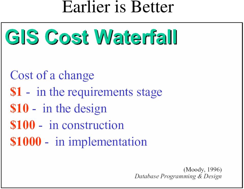
4 Earlier is Better
5 Translation of User Requirements Business Rules Model the User s View

6 Entity Relationship Diagram Good design tool, good communication tool

7 Access ERD (Relationships) You may already have an ERD tool and not know it

8 UML May look complicated, but at its heart is the ERD

9 Sacramento County ERD

10 Normalization Remove Repeating Groups Every non-key column must be dependent on all parts of the primary key No non-key column may be functionally dependent on another non-key column Introduced by E.F. Codd

11 Every attribute will refer to the Primary key, the whole key and nothing but the key, so help me Codd A table should have a field that uniquely identifies each of its records, and each field in the table should describe the subject that the table represents Database Design for Mere Mortals by Michael Hernandez

12 Database Data Models

13

14

15 Metadata

16 Database Design Fallacies Design your system to replicate existing practices You can throw your data model away when you have implemented your database I will just put it in a note Metadata is too much trouble My spreadsheet is good enough GIS shouldn t be putting its nose into everybody s business

17 More Database Design Fallacies Nobody will ever need my data Just import your shapefiles into SDE and voila you have a Geodatabase Normalized data is fast performing data Spatial data is just data

18 Database Design Truths Spatial data is just data Design on paper, then a computer Earlier is better Document deviances from the conceptual design

19 More Database Design Truths Use meaningful attribute and table names Flag for deletion, rather than delete Take the user s key away Use database constraints, rather than coded business rules

20 What is so Special about Spatial Data? How it is the same than regular data Data relationships Integrity Key Asset How it is different Spatial Key (Location is a type of key) Topology Heavy load Long transaction Advanced data type Database
 Topology Heavy load Long")
21 Early GIS
22 Community GIS
23 Evolution of the spatial data model Ian McCarg Design With Nature ArcInfo Coverages ArcStorm SDE Shape File Oracle Spatial GeoDatabase True True Spatially Spatially Enabled Enabled Database Database
24 GIS Layers Points Lines Polygons Surfaces
25 3 D
26 Scanned Maps
27 Scanned Documents
28 Attribute Data
29 Orthophotography
30
31
32 Levels of Data Integration
33 If it were a perfect (GIS) World Internet Spatial Transactions Universal Regional Database Departmental Documents
34 I can t say it was easy, but I can say it was worth it!!
35 Sacramento County Property Systems (Without data sharing) GHB/GAX Applications (Mainframe) SAP/ COMPASS (Oracle) PDB Application (Mainframe) CPS Unsecured Tax Application (Oracle) APS Permits system (Oracle) Utility Billing/ CUBS (SAP?,Oracle?) Planning Public Works Direct Levy Maintenance Application GIS (ESRI)
36 Sacramento County Property Systems GHB/GAX Applications (Mainframe) SAP/ COMPASS (Oracle) PDB Application (Mainframe) CPS Unsecured Tax Application (Oracle) County-wide Shared Property Data Warehouse APS Permits system (Oracle) Utility Billing/ CUBS (SAP?,Oracle?) Planning Public Works Direct Levy Maintenance Application GIS (ESRI)
37 Examples of Shared Data Benefits Tax Rate Areas Vineyards Utility Billing Minimize data redundancy and costs in the Regional Cooperative
38 Data Ownership, Dissemination, and Accessibility Policies Ownership - Departments own their data, GIS is the middleman Dissemination - Open Access, Cooperative Mapping based on Standards Access - Concerns over safety
39 Database Architecture Transactional Transactional Warehouse Warehouse Shared Shared Firewall
40 Summary - Benefits of Good Design Data integrity Flexibility in data retrieval and analysis Follows business rules and therefore supports organizational requirements Easier to share data Different users access same data Accommodates different views of the data Minimal Data Redundancy Breaks out of Spreadsheet mentality
41 Questions, Comments?
GIS Databases With focused on ArcSDE
 Linköpings universitet / IDA / Div. for human-centered systems GIS Databases With focused on ArcSDE Imad Abugessaisa [email protected] 20071004 1 GIS and SDBMS Geographical data is spatial data whose
INTRODUCTION TO ARCGIS SOFTWARE
 INTRODUCTION TO ARCGIS SOFTWARE I. History of Software Development a. Developer ESRI - Environmental Systems Research Institute, Inc., in 1969 as a privately held consulting firm that specialized in landuse
Data Modeling Basics. John Auel GIS Technician II United Services Group
 Data Modeling Basics John Auel GIS Technician II United Services Group Background Bachelor of Science at University of Wisconsin, Steven s Point Area of Emphasis -- Cartography Been at United Services
GIS User Guide. for the. County of Calaveras
 GIS User Guide for the County of Calaveras Written by Dave Pastizzo GIS Coordinator Calaveras County San Andreas, California August 2000 Table of Contents Introduction..1 The Vision.1 Roles and Responsibilities...1
Cookbook 23 September 2013 GIS Analysis Part 1 - A GIS is NOT a Map!
 Cookbook 23 September 2013 GIS Analysis Part 1 - A GIS is NOT a Map! Overview 1. A GIS is NOT a Map! 2. How does a GIS handle its data? Data Formats! GARP 0344 (Fall 2013) Page 1 Dr. Carsten Braun 1) A
Relational Database Basics Review
 Relational Database Basics Review IT 4153 Advanced Database J.G. Zheng Spring 2012 Overview Database approach Database system Relational model Database development 2 File Processing Approaches Based on
GIS Spatial Data Standards
 GIS Spatial Data Standards Manatee County, FL GIS Section, Information Services Department TABLE OF CONTENTS I. Introduction 2 A. Purpose 2 B. Reference 2 II. Spatial Reference Information 2 A. Projection:
The GeoMedia Architecture Advantage. White Paper. April 2002. The GeoMedia Architecture Advantage Page 1
 The GeoMedia Architecture Advantage White Paper April 2002 The GeoMedia Architecture Advantage Page 1 Introduction What is wrong with GIS? GIS is primarily about data not software. Data should be independent
Transactional Updates to Enterprise GIS data sets. Presented by: Kelly Ratchinsky PBC Countywide GIS Coordinator
 Transactional Updates to Enterprise GIS data sets Presented by: Kelly Ratchinsky PBC Countywide GIS Coordinator The Enterprise Environment Countywide GIS Centralized GIS Data Repository Departmental GIS
Abstract. Introduction
 Data Replication and Data Sharing Integrating Heterogeneous Spatial Databases Mark Stoakes and Katherine Irwin Professional Services, Safe Software Inc. Abstract Spatial data warehouses are becoming more
GIS Architecture and Data Management Practices Boone County GIS Created and Maintained by the Boone County Planning Commission GIS Services Division
 GIS Architecture and Data Management Practices Boone County GIS Created and Maintained by the Boone County Planning Commission June 2008 Background Boone County s GIS program has been in existence for
Lecture 8. Online GIS
 Lecture 8 Online GIS Lecture 8: Outline I. Online GIS 1. Google Earth 2. MSN Live Maps II. Open Source GIS III. ArcGIS Server and the ESRI suite of online software utility options IV. Advanced Data Mining
LAR-IAC4 Status and User Group Meeting. October 8, 2015
 LAR-IAC4 Status and User Group Meeting October 8, 2015 Agenda LARIAC Imagery Update LARIAC Status Update LARIAC Update and Training Schedule LARIAC Data Access Methods Additional Derived Data User Presentations
ArcGIS Reference Document
 Migration of GIS Data to ArcSDE Page 1 of 10 Table of Contents A Brief Summary of DEP s GIS Data Storage o The Y Drive o ArcSDE (Spatial Database) Keeping Your GIS Project Data Current o Checking Your
GIS Data in ArcGIS. Pay Attention to Data!!!
 GIS Data in ArcGIS Pay Attention to Data!!! 1 GIS Data Models Vector Points, lines, polygons, multi-part, multi-patch Composite & secondary features Regions, dynamic segmentation (routes) Raster Grids,
INCOG Transportation Planning Division Spatial Data Management Workflow GIS-T 2008
 INCOG Transportation Planning Division Spatial Data Management Workflow GIS-T 2008 Kevin Tartar, GISP Transportation Geodatabase Coordinator 201 West 5th Street, Suite 600 Tulsa, Oklahoma 74103 Phone:
Basics on Geodatabases
 Basics on Geodatabases 1 GIS Data Management 2 File and Folder System A storage system which uses the default file and folder structure found in operating systems. Uses the non-db formats we mentioned
ArcGIS Data Models Practical Templates for Implementing GIS Projects
 ArcGIS Data Models Practical Templates for Implementing GIS Projects GIS Database Design According to C.J. Date (1995), database design deals with the logical representation of data in a database. The
REACCH PNA Data Management Plan
 REACCH PNA Data Management Plan Regional Approaches to Climate Change (REACCH) For Pacific Northwest Agriculture 875 Perimeter Drive MS 2339 Moscow, ID 83844-2339 http://www.reacchpna.org [email protected]
ArcGIS Server Implementation HIGHS and lows
 ArcGIS Server Implementation HIGHS and lows GIS-T March 2011 Eric Abrams Iowa DOT [email protected] Agenda The Problem Timeline Future Discussion/Questions The Problem - 2006 How does Iowa DOT integrate
Editing Strategies for Enterprise Geodatabase
 Federal GIS Conference February 9 10, 2015 Washington, DC Editing Strategies for Enterprise Geodatabase Ty Fabling Esri Solution Engineer A Complete Platform Enabling GIS Everywhere Desktop Web Device
ArcGIS. Server. A Complete and Integrated Server GIS
 ArcGIS Server A Complete and Integrated Server GIS ArcGIS Server A Complete and Integrated Server GIS ArcGIS Server enables you to distribute maps, models, and tools to others within your organization
Lost in Space? Methodology for a Guided Drill-Through Analysis Out of the Wormhole
 Paper BB-01 Lost in Space? Methodology for a Guided Drill-Through Analysis Out of the Wormhole ABSTRACT Stephen Overton, Overton Technologies, LLC, Raleigh, NC Business information can be consumed many
ArcGIS 10.1 Geodatabase Administration. Gordon Sumerling & Christopher Brown
 ArcGIS 10.1 Geodatabase Administration Gordon Sumerling & Christopher Brown Key Improvements at ArcGIS 10.1 1. Easier Administration through Graphic Interfaces 2. Greater Seamless integration with Open
ESRI and Xplore Technologies 2008 Mobile Government Demonstration Project Grant Program Final Report
 ESRI and Xplore Technologies 2008 Mobile Government Demonstration Project Grant Program Final Report Introduction and Project Purpose The ESRI and Xplore Technologies Mobile Government Demonstration Project
redesigning the data landscape to deliver true business intelligence Your business technologists. Powering progress
 redesigning the data landscape to deliver true business intelligence Your business technologists. Powering progress The changing face of data complexity The storage, retrieval and management of data has
Geodatabase Programming with SQL
 DevSummit DC February 11, 2015 Washington, DC Geodatabase Programming with SQL Craig Gillgrass Assumptions Basic knowledge of SQL and relational databases Basic knowledge of the Geodatabase We ll hold
UPDATED GIS DATABASE DESIGN: Geodatabase Model
 CITY OF SUFFOLK, VIRGINIA UPDATED GIS DATABASE DESIGN: Geodatabase Model Prepared by: Michael Baker Jr., Inc. Virginia Beach, Virginia TABLE OF CONTENTS A. GEODATABASE OVERVIEW...2 B. TYPES OF GEODATABASES...3
Data Validation Online References
 Data Validation Online References Submitted To: Program Manager GeoConnections Victoria, BC, Canada Submitted By: Jody Garnett Brent Owens Refractions Research Inc. Suite 400, 1207 Douglas Street Victoria,
Guidelines for the use of the OGP P6/11 bin grid GIS data model
 Guidelines for the use of the OGP P6/11 bin grid GIS data model Report No. 483-6g July 2013 This document is a companion document to the OGP P6/11 Seismic bin grid data exchange format description (2012)
A HYBRID APPROACH FOR AUTOMATED AREA AGGREGATION
 A HYBRID APPROACH FOR AUTOMATED AREA AGGREGATION Zeshen Wang ESRI 380 NewYork Street Redlands CA 92373 [email protected] ABSTRACT Automated area aggregation, which is widely needed for mapping both natural
DATABASE MANAGEMENT FILES GIS06
 DATABASE MANAGEMENT Last day we looked at spatial data structures for both vector and raster data models. When working with large amounts of data, it is important to have good procedures for managing the
Agenda. What is GIS? GIS and SAP Real Examples
 Agenda What is GIS? GIS and SAP Real Examples Life Without GIS My Stuff My Paper Maps Features Three Elements of a GIS Attributes What parcels are adjacent to Main Street? Behavior Display Query Analysis
Best Practices for Developing Geographic Information Models
 Urban and Regional Information Systems Association 1460 Renaissance Dr., Suite 305 Park Ridge, IL 60068 (847) 824-6300 Best Practices for Developing URISA Certified Workshop August 2007 Dr. David K. Arctur,
Chapter 1: Introduction to ArcGIS Server
 Chapter 1: Introduction to ArcGIS Server At a high level you can think of ArcGIS Server as software that helps you take your geographic information and make it available to others. This data can be distributed
GEOG 482/582 : GIS Data Management. Lesson 10: Enterprise GIS Data Management Strategies GEOG 482/582 / My Course / University of Washington
 GEOG 482/582 : GIS Data Management Lesson 10: Enterprise GIS Data Management Strategies Overview Learning Objective Questions: 1. What are challenges for multi-user database environments? 2. What is Enterprise
Guidelines on Information Deliverables for Research Projects in Grand Canyon National Park
 INTRODUCTION Science is playing an increasing role in guiding National Park Service (NPS) management activities. The NPS is charged with protecting and maintaining data and associated information that
City of Tigard. GIS Data Standards
 City of Tigard GIS Data Standards City of Tigard 13125 SW Hall Blvd Tigard, Oregon 97223 503 639-4171 Page 1 of 5 1.0 Purpose The purpose of these standards is to provide guidance for geospatial data development
Chapter 2 Organizational Structure and Staffing
 In This Chapter Enterprise-Wide Organizational Models Spotsylvania County GIS Organizational Structure GIS Organizational Structure Recommendations GIS Enterprise Staffing Functional Areas Coordination
Data Dictionary and Normalization
 Data Dictionary and Normalization Priya Janakiraman About Technowave, Inc. Technowave is a strategic and technical consulting group focused on bringing processes and technology into line with organizational
ArcSDE Spatial Data Management Roles and Responsibilities
 ArcSDE Spatial Data Management Roles and The following discussion outlines the major roles and responsibilities involved in deploying your spatial data and geographic information system (GIS) applications
Introduction to GIS. http://libguides.mit.edu/gis
 Introduction to GIS http://libguides.mit.edu/gis 1 Overview What is GIS? Types of Data and Projections What can I do with GIS? Data Sources and Formats Software Data Management Tips 2 What is GIS? 3 Characteristics
Nothing in this job description restricts management's right to assign or reassign duties and responsibilities to this job at any time.
 H22111, page 1 Nothing in this job description restricts management's right to assign or reassign duties and responsibilities to this job at any time. DUTIES This is a non-career term job at the Metropolitan
GEOGRAPHIC INFORMATION SYSTEMS CERTIFICATION
 GEOGRAPHIC INFORMATION SYSTEMS CERTIFICATION GIS Syllabus - Version 1.2 January 2007 Copyright AICA-CEPIS 2009 1 Version 1 January 2007 GIS Certification Programme 1. Target The GIS certification is aimed
ISM 318: Database Systems. Objectives. Database. Dr. Hamid R. Nemati
 ISM 318: Database Systems Dr. Hamid R. Nemati Department of Information Systems Operations Management Bryan School of Business Economics Objectives Underst the basics of data databases Underst characteristics
Introduction to the ArcGIS Data Model and Application Structure
 Introduction to the ArcGIS Data Model and Application Structure RNR/GEOG 417/517 Lab 6 Presentation Overview The georelational data model Structure of ArcGIS software Structure of an ArcGIS workspace Demonstrations/previews
10. Creating and Maintaining Geographic Databases. Learning objectives. Keywords and concepts. Overview. Definitions
 10. Creating and Maintaining Geographic Databases Geographic Information Systems and Science SECOND EDITION Paul A. Longley, Michael F. Goodchild, David J. Maguire, David W. Rhind 005 John Wiley and Sons,
Editing Common Polygon Boundary in ArcGIS Desktop 9.x
 Editing Common Polygon Boundary in ArcGIS Desktop 9.x Article ID : 100018 Software : ArcGIS ArcView 9.3, ArcGIS ArcEditor 9.3, ArcGIS ArcInfo 9.3 (or higher versions) Platform : Windows XP, Windows Vista
Chapter 6: Data Acquisition Methods, Procedures, and Issues
 Chapter 6: Data Acquisition Methods, Procedures, and Issues In this Exercise: Data Acquisition Downloading Geographic Data Accessing Data Via Web Map Service Using Data from a Text File or Spreadsheet
Database Normalization. Mohua Sarkar, Ph.D Software Engineer California Pacific Medical Center 415-600-7003 sarkarm@sutterhealth.
 Database Normalization Mohua Sarkar, Ph.D Software Engineer California Pacific Medical Center 415-600-7003 [email protected] Definition A database is an organized collection of data whose content
How To Use Arcgis For Free On A Gdb 2.2.2 (For A Gis Server) For A Small Business
 For A Small Business") Esri Middle East and Africa User Conference December 10 12 Abu Dhabi, UAE Understanding ArcGIS in Virtualization and Cloud Environments Marwa Mabrouk Powerful GIS capabilities Delivered as Web services
Esri Middle East and Africa User Conference December 10 12 Abu Dhabi, UAE Understanding ArcGIS in Virtualization and Cloud Environments Marwa Mabrouk Powerful GIS capabilities Delivered as Web services
A Grid Architecture for Manufacturing Database System
 Database Systems Journal vol. II, no. 2/2011 23 A Grid Architecture for Manufacturing Database System Laurentiu CIOVICĂ, Constantin Daniel AVRAM Economic Informatics Department, Academy of Economic Studies
UltraQuest Cloud Server. White Paper Version 1.0
 Version 1.0 Disclaimer and Trademarks Select Business Solutions, Inc. 2015. All Rights Reserved. Information in this document is subject to change without notice and does not represent a commitment on
RESEARCH ON THE FRAMEWORK OF SPATIO-TEMPORAL DATA WAREHOUSE
 RESEARCH ON THE FRAMEWORK OF SPATIO-TEMPORAL DATA WAREHOUSE WANG Jizhou, LI Chengming Institute of GIS, Chinese Academy of Surveying and Mapping No.16, Road Beitaiping, District Haidian, Beijing, P.R.China,
Spatial Database Support
 Page 1 of 11 Spatial Database Support Global Mapper can import vector data from and export vector data to the following spatial databases: Esri ArcSDE Geodatabase Esri File Geodatabase Esri Personal Geodatabases
An ESRI White Paper December 2007 Enterprise GIS for Local Government
 An ESRI White Paper December 2007 Enterprise GIS for Local Government ESRI 380 New York St., Redlands, CA 92373-8100 USA TEL 909-793-2853 FAX 909-793-5953 E-MAIL [email protected] WEB www.esri.com Copyright
What Should a GIS Librarian Do?
 What Should a GIS Librarian Do? Tsering Wangyal Shawa Digital Map and Geospatial Information Center Princeton University Library [email protected] 609-258-6804 American Library Association Map and
IT Components of Interest to Accountants. Importance of IT and Computer Networks to Accountants
 Chapter 3: AIS Enhancements Through Information Technology and Networks 1 Importance of IT and Computer Networks to Accountants To use, evaluate, and develop a modern AIS, accountants must be familiar
Overcoming Bad Design! Michael Simpson Catch Intelligence SESSION CODE: 0807
 Overcoming Bad Design! Michael Simpson Catch Intelligence SESSION CODE: 0807 Agenda Introductions Learning Points History of Bad Design Winning Back Your Business Perfect Design for Change Best Practices
Oracle Data Integrator: Administration and Development
 Oracle Data Integrator: Administration and Development What you will learn: In this course you will get an overview of the Active Integration Platform Architecture, and a complete-walk through of the steps
Software. PowerExplorer. Information Management and Platform DATA SHEET
 DATA SHEET PowerExplorer Software Information Management and Platform KEY FEATURES Web-enabled Advanced, ad-hoc query capabilities Spatial E&P data presentation ZGF file import/export Spatializer Tabular
Tutorial Creating a regular grid for point sampling
 This tutorial describes how to use the fishnet, clip, and optionally the buffer tools in ArcGIS 10 to generate a regularly-spaced grid of sampling points inside a polygon layer. The steps below should
CDC UNIFIED PROCESS PRACTICES GUIDE
 Purpose The purpose of this document is to provide guidance on the practice of Modeling and to describe the practice overview, requirements, best practices, activities, and key terms related to these requirements.
Job description: Geographic Information Systems (GIS) Analyst, S20 Location: Washington Dulles International Airport
 Analyst, S20 Location: Washington Dulles International Airport") S10961A, page 1 Nothing in this job description restricts management's right to assign or reassign duties and responsibilities to this job at any time. DUTIES Serves as a Geographic Information Systems
S10961A, page 1 Nothing in this job description restricts management's right to assign or reassign duties and responsibilities to this job at any time. DUTIES Serves as a Geographic Information Systems
Mount Laurel Township MUA Hydrant Maintenance Program. Using ArcPad to Track Hydrant Flow Testing and Flushing procedures
 Mount Laurel Township MUA Hydrant Maintenance Program Using ArcPad to Track Hydrant Flow Testing and Flushing procedures What is the Mount Laurel MUA? The Mount Laurel Township, Municipal Utilities Authority
What is a database? COSC 304 Introduction to Database Systems. Database Introduction. Example Problem. Databases in the Real-World
 COSC 304 Introduction to Systems Introduction Dr. Ramon Lawrence University of British Columbia Okanagan [email protected] What is a database? A database is a collection of logically related data for
ACSG 552 Assignment #1 Spring 2009 Diana Oboikovitz. Due in class on Thursday, Jan. 22:
 ACSG 552 Assignment #1 Spring 2009 Diana Oboikovitz Due in class on Thursday, Jan. 22: Read course syllabus Read Chapters 1, 2, 3 Read lecture notes Submit answers to the following review questions & problems
http://www.esri.com/bia
 ArcGIS for Tribal Transportation Management David Gadsden Federal Account Manager [email protected] d d 1 David Gadsden GIS Background UW Geography (1995) Peace Corps Tanzania Environmental Social Science
Fact Sheet In-Memory Analysis
 Fact Sheet In-Memory Analysis 1 Copyright Yellowfin International 2010 Contents In Memory Overview...3 Benefits...3 Agile development & rapid delivery...3 Data types supported by the In-Memory Database...4
Choosing the right GIS framework for an informed Enterprise Web GIS Solution
 13 ANNUAL INTERNATIONAL CONFERENCE AND EXHIBITION ON GEOSPATIAL INFORMATION TECHNOLOGY AND APPLICATIONS Epicentre; Gurgaon, India; 19-21 January, 2010 Choosing the right GIS framework for an informed Enterprise
sensors ISSN 1424-8220 www.mdpi.com/journal/sensors
 Sensors 2009, 9, 2320-2333; doi:10.3390/s90402320 OPEN ACCESS sensors ISSN 1424-8220 www.mdpi.com/journal/sensors Article An Integrated Photogrammetric and Spatial Database Management System for Producing
The process of database development. Logical model: relational DBMS. Relation
 The process of database development Reality (Universe of Discourse) Relational Databases and SQL Basic Concepts The 3rd normal form Structured Query Language (SQL) Conceptual model (e.g. Entity-Relationship
COSC344 Database Theory and Applications. Lecture 9 Normalisation. COSC344 Lecture 9 1
 COSC344 Database Theory and Applications Lecture 9 Normalisation COSC344 Lecture 9 1 Overview Last Lecture Functional Dependencies This Lecture Normalisation Introduction 1NF 2NF 3NF BCNF Source: Section
Web and Mobile GIS Applications Development
 Web and Mobile GIS Applications Development Presented by : Aamir Ali Manager Section Head (GIS Software Customization) Pakistan Space and Upper Atmosphere Research Commission (SUPARCO) Geographical Information
The 3 Normal Forms: Copyright Fred Coulson 2007 (last revised February 1, 2009)
") The 3 Normal Forms: A Tutorial by Fred Coulson Copyright Fred Coulson 2007 (last revised February 1, 2009) This tutorial may be freely copied and distributed, providing appropriate attribution to the author
The 3 Normal Forms: A Tutorial by Fred Coulson Copyright Fred Coulson 2007 (last revised February 1, 2009) This tutorial may be freely copied and distributed, providing appropriate attribution to the author
14 Databases. Source: Foundations of Computer Science Cengage Learning. Objectives After studying this chapter, the student should be able to:
 14 Databases 14.1 Source: Foundations of Computer Science Cengage Learning Objectives After studying this chapter, the student should be able to: Define a database and a database management system (DBMS)
URISA Salary Survey for IT/GIS Professionals
 URISA Salary Survey for IT/GIS Professionals November 2011 Published by: The Urban and Regional Information Systems Association 701 Lee Street, Suite 680 Des Plaines, IL 60016 Phone: 847/824-6300, Fax:
BUILDING OLAP TOOLS OVER LARGE DATABASES
 BUILDING OLAP TOOLS OVER LARGE DATABASES Rui Oliveira, Jorge Bernardino ISEC Instituto Superior de Engenharia de Coimbra, Polytechnic Institute of Coimbra Quinta da Nora, Rua Pedro Nunes, P-3030-199 Coimbra,
Spatial data models (types) Not taught yet
 Not taught yet") Spatial data models (types) Not taught yet A new data model in ArcGIS Geodatabase data model Use a relational database that stores geographic data A type of database in which the data is organized across
Spatial data models (types) Not taught yet A new data model in ArcGIS Geodatabase data model Use a relational database that stores geographic data A type of database in which the data is organized across
A. System. City of Perrysburg, Ohio URISA EXEMPLARY SYSTEMS IN GOVERNMENT AWARD
 A. System 1. Name of System and ESIG Category Single Process System Sidewalk Maintenance and Repair Tracking application 2. Letter from the Executive Administrator See Appendix A 3. One Page Summary Every
THE ARCHIVAL SECTOR IN DW2.0 By W H Inmon
 The fourth sector of the DW2.0 environment is the archival sector. Fig arch.1 shows the architectural positioning of the archival sector. Fig arch.1 The archival sector All data that flows into the archival
Configuring Security for FTP Traffic
 2 Configuring Security for FTP Traffic Securing FTP traffic Creating a security profile for FTP traffic Configuring a local traffic FTP profile Assigning an FTP security profile to a local traffic FTP
DATA SHARING AND SPATIAL QUERY
 Technical Memorandum No. 2 DATA SHARING AND SPATIAL QUERY Raghavan Srinivasan Spatial Sciences Laboratory Texas Agricultural Experiment Station, Texas A&M University Submitted to El Paso Water Utilities
Using GIS and Virtual Reality to Manage and Inspect Building Plumbing
 Using GIS and Virtual Reality to Manage and Inspect Building Plumbing Shih, Naai-Jung 1 and Wang, Pin-Hung 2 1 National Taiwan University of Science and Technology, Taipei, Taiwan, R.O.C. 2 Kao Yuan University,