Lake Condah Sustainable Development Project
|
|
|
- Allen Clark
- 10 years ago
- Views:
Transcription
1 Lake Condah Sustainable Development

2 Contents Executive Summary 1. Introduction 1.1 The Lake Condah Sustainable Development 1.2 The Vision and Objectives of the Overall 1.3 The Purpose of this Document 1.4 The Principal Water Restoration Objective 1.5 The Aspirational Water Restoration Objectives 2. Lake Condah Description 2.1 The Natural lake 2.2 The Cultural Lake 2.3 The Drained Lake 3. Previous Water Restoration Attempts 4. Key Challenges 4.1 Land Ownership 4.2 Incomplete Data Incomplete Hydrological Knowledge Conflicting Maps Effect of the Drain on the Lake 4.3 Water Levels Need to Avoid unnatural flooding of Private Land Need to Avoid Archaeological Damage Need to Avoid Excessive Seepage Summary on Water Levels 4.4 Water Availability, Environmental and Diversion Flows Current Status Water Modelling for Dry Years Water Modelling for Mean Years Environmental and Diversion Flows Summary on Water Availability 4.5 Managing Stakeholders 5. Implementation 5.1 Risk Assessment and Management 5.2 The Proposed Method of Water Restoration 5.3 The Proposed Water Levels Current Water Levels With an Outlet Water Level Regulator Effect on surrounding Land Land West of Lake Land Upstream Land Downstream 5.4 Delivering Desired Outcomes Management Partnership Trained Personnel Develop and Implement an Adaptive Water Management Regime 5.5 Data Confirmation 5.6 Securing Investment Funds 5.7 Summary of Action Plans Page Lake Condah Sustainable Development Page 1

3 Contents continued 6. Action Plan Tables, Timeframes and Indicative Costs 6.1 Consultation Strategy 6.2 Land Acquisition and Consolidation 6.3 Interim Works Diversion Works Maintenance Channel Filling Removal of Cattle Removal of Fencing Improved Access 6.4 Data Confirmation 6.5 Adaptive Management Joint Venture in Management Personnel Water Regulation Management and Monitoring Archaeological Monitoring and Protection 6.6 Outlet Water Level Regulator 6.7 Possible Associated Works with Applications and Licences 6.9 Management Plan 6.10 Tourism Assessment 6.11 Record Retention 6.12 Funding 7. Concluding Remarks Page Acknowledgements Acronyms References End Page Maps, Tables & Charts Page Photographs Page Locality Map Lake Condah Map Ingram s 1883 Lake Sketches Table 4A- Water Requirements Table 4B- Water Modelling Risk Assessment & Management Table 5.3A- Current Water Levels Table 5.3B- Desired Water Levels Chart 5.3C- Water Level Effect at 52.0 AHD Chart 5.3D- Water Level Effect at 52.5 AHD Summary of Action Plans 5 6 & Water on Lake July aerial Photomontage Dry Lakebed Southern end Water on South end July 2004 First floodwaters April 2004 NW Arm of Lake June 2004 Main drain near OWLR site Diversion Weir Flooded Diversion weir East-west drain and Main Drain Aerial View 2001 Drain to sinkholes Fencing on Lakebed Aerial View July Lake Condah Sustainable Development July 2004 Lake Condah Sustainable Development Page 2

4 Executive Summary This year represents the 50th anniversary of the final draining of Lake Condah and the 40 th anniversary of the first proposal by the former Fisheries and Wildlife Division to restore permanent water to the Lake. The Key Water Restoration Objective is the return of water to Lake Condah in as permanent way as possible, given the constraints of water availability and non-interference with private land holdings above, below and surrounding the lake. Believed to be 8,000 years old and covering some 600 acres, Lake Condah was a superb, environmentally rich wetland; providing a breeding habitat in particular for birds and fish. Testimonies from those who lived and worked alongside the Lake prior to 1954 state that it was a permanent body of water in all but the rare, very dry seasons. As a wetland, the Lake s biodiversity was dependent on the rise and fall of water levels. The cultural Lake was built on this very fact. Fishtraps at the Lake operate over a wide range of water levels. Aboriginals modified the Lake several thousand years ago, to develop a sophisticated and extensive aquaculture system. Whilst the wetlands of Lake Condah will be of State significance, the archaeological sites at Lake Condah are considered to be of world importance because they preserve critical evidence of technological and social developments, which exemplify the transition from a nomadic hunter-gatherer lifestyle into a semi-sedentary society. Almost nowhere else in the world has dry stone heritage sites been preserved on the scale found at Lake Condah. Falsely blamed for flooding the Condah Swamp area in 1946, the Lake was drained of permanent water in Subsequent attempts to restore water to Lake Condah failed with power and position taking precedence over purpose. Only the Northwest arm of the Lakebed is privately owned and acquisition of this land is a key to the project proceeding without compromise. 50 years of not having permanent water on the Lake creates gaps concerning the hydrology of the Lake but still, much is known. Previous research has shown that land above and below the Lake will not be affected by water restoration, nor will groundwater levels be affected south of the Lake. An adaptive water management regime is proposed to avoid unnatural flooding of private land; to avoid archaeological damage and facilitate its further study; to avoid excessive seepage and to maintain water levels high enough to restore the Lake s biodiversity and facilitate the development of sustainable tourism and aquaculture businesses. Water availability, seepage and evaporation modelling indicates water coverage can be maintained all year. Initially, this will require some flood flows. If permanent water restoration had been attempted in 2002 or 2003, it would have failed but would have succeeded in In all probability it will take several years of mean (or greater) rainfall and stream flow to restore permanent water to Lake Condah Sustainable Development Page 3

5 Lake Condah. As was concluded by Rural Water Commission in the 1987, the only real way to prove the accuracy of conceptual modelling is to put water into the Lake and observe what happens. To this end a Learning period is proposed as part of the Adaptive Water Management Regime. The proposed method of water restoration to the Lake is to construct an Outlet Water Level Regulator on the Main Drain. The process of design, consultation, approval and construction will take approximately two years; with the project estimated to cost $335,000. It is not proposed to recommission the Diversion weir, which was a failure. The Outlet Water Level Regulator will give the Lake its best chance of retaining permanent water; will best facilitate re-establishment of the Lake s biodiversity; will allow more of the Lake s archaeology to be operational at various times of the year than any other proposal; and best deals with the restrictions of the Main Drain running through the Lake, without compromising the operation of the Drain. The desired summer autumn average water depths are 1.0 metre in that part of the Lake north of the Lava Ridge and 1.5 metres south of the Lava Ridge. These are seen to be the optimum water levels and most closely resembling the pre 1954 Lake circumstances, which even then was affected by a lesser drain through the Lake. Risks have been assessed and management proposals developed for them. Extensive Action Plans have been designed to deliver the project. This Water Restoration is one of the most significant wetland restoration projects currently being undertaken in Victoria. It will undoubtedly be one of the most significant archeological restoration projects in Australia, attracting keen and warranted international attention. It can be achieved without detriment to the district farmers who historically have opposed it. The further development of the Aspirational Objectives will deliver economic opportunities through aquaculture and tourism developments. The tourism potential of the cultural Lake is of national and international significance. It all begins with the restoration of permanent water to the Lake. Water on the Lake in early July Looking westwards, the Lava Ridge is in the centre of the photo. By the end of July there were more than 50 swans nests on the northern section of the Lake. Hopefully sufficient water will remain to complete the breeding cycle. Lake Condah Sustainable Development Page 4

6 Lake Condah Sustainable Development Page 5

7 Lake Condah Sustainable Development Page 6
8 1. Introduction 1.1 The Lake Condah Sustainable Development The Lake Condah Sustainable Development (LCSDP or ) is an innovative partnership approach to sustainable development based on exciting, visionary, yet achievable concepts. The, based on the restoration of water to Lake Condah, encompasses wide ranging economic, social, cultural and ecological benefits. A broad range of stakeholders and interested parties has linked together to help commence the. Included in this group are the Indigenous community; Federal, State and Local Government bodies and authorities; private enterprise and individuals. The will make a difference at many levels. It is anticipated that it will provide the impetus for engagement, practical reconciliation and healing for Indigenous and non-indigenous communities in the South West of Victoria. Major aspects of the include sustainable job opportunities associated with a significant tourism attraction, environmental management and cultural preservation, together with significant historical, natural and cultural heritage, ecological, economic and educational outcomes. Lake Condah is a nationally significant site showcasing unique and remarkably well preserved archaeology, coupled with historical and environmental aspects of Australia s Indigenous culture. Prior to drainage, Lake Condah was a stunning example of Australian biodiversity. It is hoped to regain this biodiversity. An Executive Committee with broad representation of key stakeholders has been established to oversee and direct the detailed work required to achieve the goals of the. This Committee has been successful in seeking funding from several sources for the first stage of the LCSDP implementation phase. 1.2 The Vision and Objectives of the Overall The vision of the Lake Condah Sustainable Development is the sustainable development of the significant natural and cultural assets of the Lake Condah area through a unique partnership of Aboriginal and non- Aboriginal peoples, corporations and Governments. The Lake Condah is based on an integrated Master Plan. Key components of the development include: Gaining National Heritage listing followed by World Heritage listing for the Lake Condah area; Restoring water to Lake Condah to revitalize the wetlands and reactivate the traditionally constructed aquaculture system; Re-building the old mission Church at Lake Condah; Developing a communications and knowledge network to foster the education and understanding required for long-term sustainable tourism development; Lake Condah Sustainable Development Page 7

9 Developing employment and enterprise activities focused on tourism, aquaculture and related activities. 1.3 The Purpose of this Document The Lake Condah Water Restoration is a major component of the LCSDP and is the subject matter of this Plan. Draining the Lake commenced shortly after 1886 and was concluded by Despite various attempts over a period spanning 40 years, the Lake still remains dry today except for shortterm inundation. The purpose of this document is to establish a detailed Plan for the restoration of water to Lake Condah, after consideration of previous proposals and taking the advice of the Lake Condah Water Restoration Sub- Committee. The LCSDP Leadership Group established the Lake Condah Water Restoration Sub-Committee to scope previous water restoration proposals and to provide advice on the best method to restore water to Lake Condah. The Sub-Committee convened its first meeting on Thursday 5 February The Sub Committee has been an important source of advice and advocacy for the restoration of water to Lake Condah, determining water levels and methodology. This Lake Condah Water Restoration Business Plan has been developed so as to be consistent with the aims and objectives of the larger Lake Condah Sustainable Development, as stated in Section 1.2 above. 1.4 The Principal Water Restoration Objective The Key Water Restoration Objective is the return of water to Lake Condah in as permanent way as possible, given the constraints of water availability and the non-interference with private land holdings above, below and surrounding the lake. 1.5 The Aspirational Water Restoration Objectives The following Aspirational Objectives flow from the restoration of water to the Lake: (1) Preservation and display of the archaeology at the lake, which is of world significance; (2) Restoration of wetlands of State significance; (3) Re-establishment of as much of the original biodiversity of the Lake as is possible; (4) Re-development of an Indigenous aquaculture business, based on eels; and (5) Development of a culturally sensitive tourism industry based on the Lake and it s many natural and cultural heritage values. Lake Condah Sustainable Development Page 8

10 LAKE CONDAH WATER RESTORATION BUSINESS PLAN 2. Lake Condah Description 1947 aerial photomontage of Lake Condah showing significant water coverage and the old drain through the Lake (Obtained from the archives of Glenelg Hopkins Catchment Management Authority). Lake Condah Sustainable Development Page 9
.")
11 2.1 The Natural Lake Whilst current scientific opinion estimates the lake to have formed 8,000 years ago, the first written description of Lake Condah occurs in the Portland Mercury on 11 th January The find was reported by Mr. Edgar of Second River (later named Heywood) and his two companions as follows: a splendid fresh water lake about a mile and a half long and three quarters of a mile wide, and contains almost every variety of fish in abundance, with swans, ducks &c. It is of considerable depth, and receives a river about fifty yards broad; one side is bold and rocky and contains a number of small coves into one of which a beautiful stream empties itself, and the other side is a gently sloping shore surrounded by a fine tract of country. Long-term district residents further attested the natural attributes and biodiversity of the Lake, all of whom had an involvement with the Lake from the 1930 s onwards. The late Mr. James Vaughan stated before the major drainage schemes were implemented, There was generally permanent water over the Lake area. Only during rare and very dry seasons did it go dry. This provided a habitat for regular breeding programs of the main types of wild life, in particular birds and fish. White Ibis had extensive colonies on typical breeding rafts in the Lake. He referred to prolific breeding of ducks. (Source: VFGA Submission on Lake Condah, 1978). The late Mr. W.R. Malseed stated: There was permanent water in the northern end of Lake Condah to a depth of approximately 18 in depth over the period from 1933 until major draining operations in This loss of water caused loss of reed beds and associated aquatic life, which supported large populations of many species of waterfowl. They almost blotted out the sky when they took off. (Source: VFGA Submission on Lake Condah, 1978). Mr. Roy Vaughan and his wife, who lived and farmed alongside the Lake for many years prior to its drainage, described the summer water depth at the northern end of the lake as generally being waist deep, except for the rare dry year (Personal communication June 2004). A different reference point is the most likely reason for the variation in water depth. The late Mr. Hector Field described the Lake as essentially a permanent body of water prior to major drainage activities. The water in places, particularly over the southern section of the lake was so deep that on duck shooting excursions, it was reached only by boat Fish were available in very large quantities especially Toupong and Tench. After drainage the stench from dead fish could be smelt up to a mile away. (Source: VFGA Submission on Lake Condah, 1978) The natural Lake, whilst mostly a permanent body of water had fluctuating water levels. We know this from the different elevations of the fishtraps constructed and used by the Aborigines at the Lake over a period of several thousand years. Wetland Care Australia defines a wetland as areas of land that are either temporarily or permanently covered by water. Wetlands support a large variety of plant and animal species that are adapted to fluctuating water levels. (Source: What, Why & How Wetlands Work, Wetland Care Aust.). Lake Condah Sustainable Development Page 10

12 By this definition Lake Condah is a wetland. It was the rising and falling water levels that allowed the Lake to develop a uniquely diverse ecosystem. Shallow water, deep water, warm water, cool water all simultaneously available together with flood waters spreading out over the shallow sections of the Lakebed followed by receding water and a year round flow of water - created a rich and self-sustaining wetland area. The drying cycle stimulated growth and breeding in food chains, with particular benefit to small native fish species, which in turn provided food for larger fish species and bird life. The Lake offered spawning and breeding sites, nursery sites, protected sites, diverse habitat and was a complete food bowl for fish, birds, animals and insect life. This environment was especially attractive to eels. Lake Condah was a healthy, self-sustaining wetland supporting huge quantities and varieties of birds, fish and insect life. This biodiversity was dependent on the rise and fall of the Lake water levels. 2.2 The Cultural Lake Lake Condah was not only a natural Lake with stunning attributes but it was also a cultural Lake of world significance. Referring to the Mt. Eccles lava flow (of which Lake Condah is a part), Dr. H. C. Builth wrote: The environmental conditions provided unique opportunities for the local Indigenous people. Aboriginal adaptation to this environment had evolved to a highly organised and efficient level prior to European contact. Gunditjmara had evolved a cohesive social and economic system with its foundation firmly interwoven with a spiritual knowledge base. (Source: Builth 2002, The Archaeology and Socioeconomy of the Gunditjmara) Aboriginal people usually do not distinguish between natural and cultural values in environmental resources. In general, Aboriginal people see natural and cultural values of the country as interwoven so that looking after the land, waters, plants and animals means looking after culture; and looking after culture means looking after the land, waters, plants and animals. The practical importance of the interweaving of nature and culture is that many places and features of cultural importance to Aboriginal people also have significant natural heritage values; and equally, many places which have natural heritage values also have cultural importance to Aboriginal people. (Source: SAMLIV 2003). Lake Condah is such a place. Aboriginals modified the Lake environment by building fishtraps, races, stone weirs and walls. The route of each stone race and canal has been carefully chosen to take full advantage of the natural topography, generally following drainage lines. In order to confine fish within a system, stone walls have been constructed to supplement the natural barriers that define the margins of the system. Such walls may also have served as walk-ways, facilitating movement around the system. (Source: Records of the VAS June 1978 Aboriginal Engineers of the Western District, Victoria, Coutts, Frank & Hughes). Lake Condah Sustainable Development Page 11

13 More recent understanding of the archaeology suggests that these very walls may have been used to artificially retain water for longer periods. The overall outcome of these lake modifications was an extensive aquaculture system and related economy. Surveyor A. Ingram s January 1883 sketch of Condah Swamp, Lake Condah and diagram of a section of Fishtrap area No.6, showing channels and fishtraps (Courtesy of the South Australian Museum). Lake Condah Sustainable Development Page 12

14 The archaeological sites at Lake Condah are considered to be of universal importance because they preserve critical evidence of technological and social developments which exemplify the transition from a nomadic huntergatherer lifestyle into a semi-sedentary society and which are characteristics of incipient agrarian peoples. By world standards, the archaeology of the Lake Condah region has received only limited study. Nevertheless, the investigations of this area have revealed a scale and quality of sites which is not found elsewhere. The challenge now is to develop a more complete understanding of the dating, chronology, function and hydrological context of those sites. (Source: VAS Nov 1992, Lake Condah: Review and Assessment, van Waarden & Simmons) Dr. J.W. Rhoads summed up the importance of the Lake Condah archaeology writing: ancient heritage sites infrequently survive and almost nowhere else have they been preserved on a scale of the Lake Condah sites. (Source: The Occurrence of Dry Stone Structures: World-wide Review of Ethnographic Literature, Dr. J.W. Rhoads July 1992). 2.3 The Drained Lake The arrival of Europeans who wanted farmland inevitably meant that fertile wetlands would be drained. This was the case with the Condah Swamp area, encompassing some 6,300 acres to the immediate north of Lake Condah (refer Ingram sketch on previous page). Drainage of this area commenced in January 1886 and by 1908 the Leader Newspaper reported that Lake Condah was being blamed for damming back floodwaters. The article advocated draining the Lake and making the 600 acre Lakebed available for selection. The Lake would appear to have been partially drained at this stage but with no drain maintenance, increasingly less effective with time. The last reported regular Aboriginal fishing of the Lake was in 1909 (Source: VAS Occasional Report No. 35, Penney & Rhodes, Lake Condah, 1990), although this was probably a result of Mission restrictions. After years of not maintaining the drains, the 1946 floods extensively damaged the Condah Swamp area and drainage system. Lake Condah was again blamed. In 1954 the drain through the Lake was deepened (as it was for the whole drainage system, often using explosives) and from then, the Lake has never held permanent water. In addition, further drains were carved into the lakebed to reinforce this status. As V.K. Hand (the drainage surveyor and engineer) wrote in his 1973 Report Coinciding with the re-construction programme commenced in 1954 the water impounded on Lake Condah diminished and finally virtually disappeared. (Source: V.K.Hand, Report on a Proposal to Contain Surface Water on the Area known as Lake Condah, 1973). Since 1954, Lake Condah has only ever been subject to short-term inundation. Fifty years later this still remains the case. Lake Condah Sustainable Development Page 13

15 LAKE CONDAH WATER RESTORATION BUSINESS PLAN The dry Lakebed looking across the southern end from a stone ridge th The same area on 29 July 2004 with water depth averaging 1300mm Lake Condah Sustainable Development Page 14

16 3. Previous Water Restoration Attempts In 1964, just 10 years after the final drainage of the Lake, the then Fisheries and Wildlife Division (FWD) made a submission advocating that Lake Condah become a State Wildlife Reserve. By implication, this meant restoration of some water to Lake Condah. In 1973 the Land Conservation Council supported this view and in 1977 the Victorian State Government gazetted Lake Condah as a State Wildlife Reserve. In 1970, FWD sought permission to build a weir at the lake outlet. This was after the Condah Swamp Drainage Authority had permitted the building of six concrete weirs on the Condah Swamp system to hold water over summer (although by 1973 only three had been built). The 1954 drain was too deep, too efficient and the Condah Swamp land suffered from being too dry. State Rivers & Water Supply Commission (SR&WSC) did not give its permission to the FWD weir proposal. In 1972, FWD commissioned V.K. Hand to write a report (refer section 2.3 above) on water restoration, which suggested the possibility of a weir at the northern end of the Lake to divert water into the Lake. In late 1973, SR&WSC issued a report echoing Hand s report but it was not until 1990 that this weir was actually built and then, only as a trial. In 1977, the FWD Secretary, R.J. Mitchell wrote to the Shire of Portland, proposing a weir near the outlet and said: The main issue is to attempt to restore the original water regime to Lake Condah. With the reconstruction of the Condah Swamp drain and the resultant lowering of the drain water levels, the Division firmly believes that Lake Condah has been denied its normal water regime. (Source: FWD letter to Shire of Portland, 30 th June 1977). This became the line in the sand and commenced a regrettable period where power and position took precedence over purpose. What ensued was a sustained and prolonged attack on the project. In 1986, FWD proposed a trial flooding of Lake Condah over the summer of on just the south end of the Lake. The proposal by this time had been significantly reduced both in terms of area to be covered and the depth of water, such was the pressure placed on the project. The trial flooding eventually commenced on 1 st November The trial was short lived and its demise blamed on vandalism at the weir. In fact the weir did not do the job, with water drying up quickly; compromising the breeding cycle of water birds. So, the project remained dormant until 2002 when the LCSDP Partnership was established at the instigation of the Indigenous community, receiving broad community support. The actual cost of constructing the trial weir and diversion channel is not known (key files have not been kept by relevant organisations). Investigation and design costs were estimated to be $13,800 in During the mid- Lake Condah Sustainable Development Page 15

17 1980 s $300,000 from the State Government was spent on research associated with the water restoration proposal and at the Lake Condah Mission site. None, other than for a new culvert bridge, appears to have been spent on physical works at the Lake. Originally, the $300,000 was to be allocated $70,000 for a Feasibility Study and $230,000 for flooding works, access works, bridge and toilets. There is no record of such a Feasibility Study being done. Since 1964, FWD s total spend on the project is incalculable. The way in which FWD and its successor bodies continued to pursue this project, despite the difficulties and opposition encountered over a period of decades is noteworthy. It is also worth noting that until late 1986, the proposal to restore water to Lake Condah was essentially a wildlife habitat restoration proposal. The first mention of Aboriginal involvement only occurs on 12 th November 1986, when Kerrup Jmara Elders became involved with the Lake Condah Investigatory Committee. This committee was the first time all stakeholders came together on the same committee. It was at this point that water restoration to the Lake started to take on board indigenous cultural values as well. Fifty years after the Lake was finally drained and forty years after the first proposal to restore water, the lakebed is still dry, except for temporary winter and spring flooding in some years is one such year where significant amounts of floodwater have flowed onto the lakebed. First floodwaters in April 2004, immediately attracting Birdlife. Lake Condah Sustainable Development Page 16

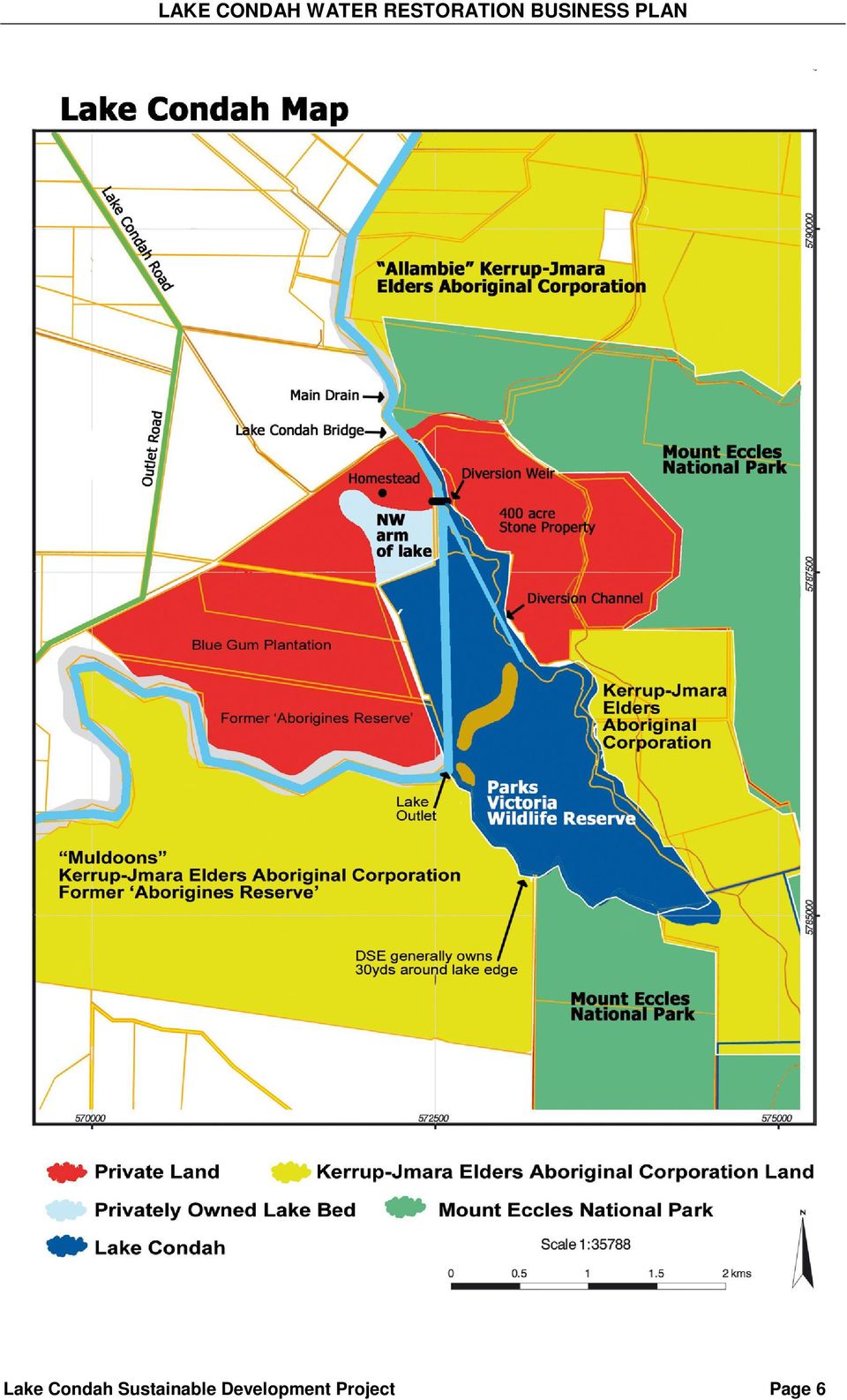
18 4. Key Challenges 4.1 Land Ownership The Lake Condah Map (next page) indicates the current ownership status of land surrounding the Lake. With the exception of 400 acres of privately owned stone country on the north east corner of the Lake, all land to the east and south of the Lake is either owned by the Kerrup Jmara Elders Aboriginal Corporation or Parks Victoria. This 400 acre block should be acquired to complete indigenous ownership of the Lake s east side and to remove cattle from the Lake. The Lakebed is generally owned by Parks Victoria with the Department of Sustainability and Environment owning strips of land around the Lake. Land on the west side of the Lake is all privately owned, including the Northwest arm of the Lakebed. This piece of Lakebed has to be acquired (or a suitable permanent agreement reached) before the proposed Outlet Water Level Regulator can be operated. This is a key issue in restoring permanent water to Lake Condah without compromise. A decision needs to be made regarding land on the west side of the Lake regarding its usefulness as a buffer zone. It may be appropriate that this land is progressively acquired as it becomes available for sale. Northwest arm of the Lake partially covered with floodwater 19th June Lake Condah Sustainable Development Page 17

19 Given that Kerrup Jmara Elders Aboriginal Corporation is in liquidation; the likelihood of further land acquisitions, Native Title Claims and the number of different Government departments involved in land ownership at the Lake, there is a need to rationalize the landholdings. Lake Condah Sustainable Development Page 18

20 4.2 Incomplete Data Incomplete Hydrological knowledge on how the Lake operates Whilst State Rivers & Water Supply Commission and its successor body Rural Water Commission, investigated in detail the hydrology at and surrounding the Lake during the 1970 s, 1980 s and the early 1990 s, some information about how the Lake actually operates hydrologically remains unknown. The primary reason for this incomplete knowledge is simply the Lake not having permanent water over the last 50 years. A secondary reason is the loss of files on Lake Condah. What we do know from those investigations is: 1. The SR&WSC Report to FWD titled Lake Condah Water Supply Investigations and dated October 1980 (unpublished) recorded: The following conclusions have been reached from the hydrological investigations: (i) Waters from the Lake Condah Main Drain could be diverted to Lake Condah (both north-west and south-eastern portions included) without adversely affecting the Lake Condah Drainage Scheme and interests of the users of the water downstream. (ii) The flows to Lake Condah would need to be regulated during the four months January to April, in order to give priority to downstream users of water. (iii) In the absence of any firm figures for losses through seepage, no guarantee can be given that the required pondage depth, during the periods requested, will be maintained. 2. In a letter dated 26 May 1987, from J. Oates (Snr. Exec. Engineer) RWC to the Regional, DCF&L it is stated that the effects of filling the lake, on flood discharges downstream or flood levels upstream from the lake will be negligible as the lake volume is too small compared with normal flood volumes. This was specifically in relation to proposed lake level of 50.5AHD. 3. In a RWC internal memorandum from Snr. Geologist F. Cox to the Principal Geologist dated 8 December 1989, titled Lake Condah hydrographic monitoring Notes on Bore Water Levels and Sink Hole Levels South of the Lake; it was concluded: Data to November 1989 indicates that there is no significant effects due to flooding of Lake Condah at distances exceeding 2.75 km from the Lake. Those bores and sink holes monitored were not affected by lake levels. This was confirmed in 1993, when RWC again concluded: no response can be determined as being due to the flooding of Lake Condah in 1991 and (Source: RWC Internal Memorandum from J. Oates to I. Potts, dated 4 th March 1993; titled Lake Condah Groundwater Monitoring Review ). Lake Condah Sustainable Development Page 19

21 What we do not know at this stage about the Lake hydrology includes: 1. What the actual Lake seepage rates are at each half-metre increment in water level. SR&WSC estimated seepage losses of 529 ML/month on the basis of four month s observation to November 1979, when the water level dropped an estimated 1.5m. This assumption appears to be flawed in that seepage/drainage rates would have been accelerated, especially at higher water levels because the Lake had internal drains built in 1954 to speed up the drainage process. Modelling in this document has used both these original seepage rates and some lesser rates (refer Table 4B). 2. What the actual difference between winter-spring and summer-autumn water levels will be. Previous water restoration proposals have assumed it will be only half a metre. This is unsubstantiated. 3. What the critical minimum spring water depth is to retain water all year round on the Lake. The solution remains the same as RWC advised DCF&L in 1987; that Trial flooding of the Lake will provide the most accurate estimates of seepage and provide advice on likely effects (J. Oates, RWC to D. Read, DCF&L, unpublished letter dated 26 May 1987) Conflicting Maps There are two known contour maps of Lake Condah. The first and oldest map is referred to in this document as the 1980 State Rivers and Water Supply Commission (SR&WSC) Contour Map. It was developed from a November 1979 field survey and placed over a 1972 aerial photomontage. It has 0.5m contours. The second map is a Vicmap 1989, Ministry for Planning & Environment / VAS map with 1m contour Intervals and is based on GIS technology. One (or both) of the maps is incorrect in that the AHD reference point used is wrong. Which one is incorrect is not known. In this document, the 1980 SR&WSC AHD datum has been used for the following reasons: It was the datum used for the Condah Swamp drainage system including the Main Drain; It was the datum used for drainage of the Lake; Permanent markers adjacent to the Lake use this datum (although they appear to have been interfered with); It was the datum used to build the Diversion Weir and channel at the north end of the Lake; and It is consistent with previous attempts to restore water to the Lake. The two maps have a range of differences from 1m to 1.9m in the lakebed elevations. Part of the difference is explained by one map picking up an incorrect AHD reference point but it does not explain all of the variations. Lake Condah Sustainable Development Page 20
22 In this context, the outcomes (including a 200mm contour map) from the planned aerial GIS survey are critical for the construction of the planned Outlet Water Level Regulator. This GIS survey will enable accurate modelling of outcomes from the operation of the proposed Outlet Water Level Regulator. Digital elevation models (DEM) will accurately predict the depth and coverage of water in the Lake at various elevations. The data capture is planned for 2004 with the full results becoming progressively available over the following 18 months The Effect of the Drain on the Lake It would appear that no research has been done on whether the substantially deepened Main Drain running through the north and west side of the Lake will have an effect on the lake s ability to retain water. Did deepening the drain break the mud seal over the underlying permeable lava flows, alluvium or limestone? If so, then greater seepage losses can be expected. Should this occur, the solution will be to identify the leaks and reseal the drain floor with spoil from the spoil banks at those points where water is leaking downward through runaway holes. Given three decades of uninterrupted silt build up, this is unlikely to be an issue. The Main Drain as it heads west away from the Lake. The proposed Outlet Water Level Regulator could be upstream or downstream of this bend. Lake Condah Sustainable Development Page 21
23 4.3 Water Levels The key challenges associated with water levels are: Need to avoid unnatural flooding of private land Under the Water Act of 1989, it is an offence to place nuisance water on private land. This must be avoided. The only safe way to control this risk is to acquire all affected land, of which there appears to be only one property. Measures are proposed to ensure no other properties will be affected. In the period leading up to the commissioning of the Outlet Water Level Regulator, any water on privately owned land would be naturally occurring water inundation (Refer photo at page 16 of the NW arm of the Lake in June 2004). However, with an Outlet Water Level Regulator, water can be held permanently and at higher levels (up to 52.0 AHD). This will result in permanent or semi-permanent flooding of the privately owned lakebed Need to avoid Archaeological damage It is improbable that permanent water restoration will cause any archaeological damage; given that various fishtraps appear to operate over a water level range of at least 4.5m. It needs to be acknowledged that Lake Condah s archaeology is far more complex than is presently understood. The Lake archaeology is of world significance and data collection is significantly incomplete, as is our understanding of it. It is therefore best to be cautious in initially restoring water levels. Water levels will also need to be managed to facilitate further study. Once again, the proposed 200mm contour map will be important in understanding how the fishtraps worked. Issues such as rabbit burrows in the vicinity of fishtraps need be considered, and where found, filled in so as to avoid the possibility of collapse Need to avoid excessive seepage There are at least five areas on the Lake where it was drained to an approximate 50.5 AHD level or less, in1954 and reinforced in Some of these will need to be filled in so as to be able to maintain the desired water levels. Careful observation of leakages is required in the initial years of water restoration, and solutions developed. This may involve claying some rock walls but the lake did hold permanent water from 1909 to 1954 without this being done. Once the proposed GIS flyover has been done, digital elevation models of the lake should identify any likely leakage problem areas. Lake Condah Sustainable Development Page 22
24 4.3.4 Summary on Water Levels Treating the first years of permanent water restoration as a Learning period is essential to gaining a body of knowledge regarding the most appropriate water levels for the Lake. In the first years this may mean lower than desired water levels, should the suggested confirmation process not eliminate all concerns. Careful observations and recording of what happens to water levels will form the basis of an appropriate Adaptive Water Management Regime for the Lake. 4.4 Water Availability, Environmental and Diversion Flows Current status We know that pre-1954 the Lake held permanent water. What has changed since 1954 in terms of water availability? A general change in the pattern of rainfall with heavy autumn falls less frequent (lack of a regular cycle); The weirs on the Condah Swamp drains diverting some water over summer and autumn; The influence of the neighbouring bluegum plantation (lowered water table?); There are no active springs directly feeding the Lake, as was the original scenario (probably a direct consequence of drainage); and The Drain itself. The combined effect of these changes is unknown, other than it is a reasonable assumption to say that water availability is less than it was pre It is noted that the Victorian Government s White Paper Securing our Water Future Together (June 2004) proposes a Stream Flow Management Plan for the Darlots Creek within 5 years, the aim of which is to reduce water diversions over summer and autumn. The only water flow data currently collected in the district is at the Homerton Bridge, south of the Lake. Data was collected for 4 years at the Lake Condah Bridge but ceased in There was one year of overlap with the two data collection sites. Whilst that year indicated that water on average at Lake Condah Bridge would be about 80% of that at Homerton Bridge, this is not conclusive. In 1980, SR&WSC estimated the relationship at 86% but by 1987 RWC Engineers had restated the relationship to 35% of Homerton Bridge flows when water was flowing at less than 80ML/day and at 160% where the flow was greater than 250ML/day. They concluded: There is adequate water in the Drain in the winter months, even in the driest year of 1982, to allow a constant flow into the lake, (although the minimum flow required to maintain the lake level will not be known until after the trial filling). (Source: RWC Internal Memorandum from Design Engineer R. Evans, to Executive Engineer, dated 13 April, 1987). Lake Condah Sustainable Development Page 23
25 It is therefore important to fill the Lake to a sufficiently high level in winter - spring so as to achieve the desired summer-autumn level, allowing for seepage and evaporation losses. Floodwaters will be useful in this process, if not necessary. Monitoring of water flows in the Darlots Drain should commence immediately to determine the accuracy of water modelling assumptions Water Modelling for Dry years Using the Homerton Bridge data, there has been 5 years in the 34 year period to 2003 where the annual flow has been less than 20,000 ML. For the purposes of this exercise, a dry year has been defined as 24,400 ML pa or less, against a mean stream flow of 49,904 ML pa. Using the same assumptions made by SR&WSC in their 1980 modelling, the following Table indicates that the Lake will dry up each summer in dry years. It is relevant at this stage to make some comments on these assumptions. Firstly, the relationship between flow rates at Lake Condah and Homerton Bridge cannot be regarded as accurate. Secondly, the evaporation rates are based on Rocklands Dam figures. Of all the assumptions made, this one is likely to be the most accurate. Thirdly, seepage rates for the whole Lake are based on anecdotal evidence that the Lake dropped 1.5m in water height in the four months to November This was calculated to be equivalent to 529 ML / month. This is likely to be inaccurate for several reasons: The rate of water loss would have been exaggerated as the Lake was artificially drained to 50.5 AHD at several locations. The rate of seepage would not have been a constant 529 ML / month, all year round. It would be reasonable to suggest that the seepage rate declines with the decrease in Lake volume. The 1979 observations indicate that the spring water level was at least 52.0 AHD, assuming that by November the Lake was at 50.5 (the level at which the Lake was drained to). It may have been greater. The water on the Lake was from floodwaters only was slightly below the mean year datum recorded at Homerton Bridge. Allowing for the above factors, the modelling was re-worked with lesser seepage rates at different trigger points. The Lake still remained dry. The modelling of water availability is based on a Drain Environmental and Diversion flow below the Diversion Weir of 30 ML/day (when available). Lake Condah Sustainable Development Page 24
26 4.4.3 Water Modelling for Mean Years As defined above, a mean annual stream flow is 49,904 ML. Even at these flow rates, the modelling indicates that the Lake will still dry up, using the SR&WSC assumptions. It is only when the seepage assumptions are reduced and coupled with flood flows increasing the overall Lake volume that water appears to be retained all year. This is the known factual circumstance of the Lake - that it did have permanent water all year round, in all but unusually dry years Environmental and Diversion Flows DCE (now DSE) determined in 1991 an environmental and diversion flow for the Darlots Creek of 30 ML/day, subject to its natural availability. As an operating condition, the Diversion Weir located at the north end of the Lake was only to operate if the flow in the Main drain is greater than 30 ML/day. It is not proposed to change this requirement. The following table indicates that the Lake in a mean stream flow year will only take 12% of available water, before the effects of flooding, whilst maintaining the environmental and diversion flow requirement. Table 4A Water Requirements of the Lake Available Water Allocation Dry % Mean % Mean % Year Year Year(1) 24,400ML 49,900ML 49,900ML Environmental & Diversion Flow 8,200 10,520 10,520 Excess water 11,400 33,461 32,785 Darlots Creek Total flow 19, , , Water into Lake Condah 4, , , Total Water Available 24, , , The above table is based on the same information and assumptions specified in the next table (4B). It is based on the Darlots Drain (at the Lake) having a minimum daily flow of 30 ML/day. (1) Assumes an additional 676 ML of floodwater flows into the Lake. No allowance has been made for water flowing back out of the Lake into the Drain or indeed via springs into Darlots Creek. Both situations will increase the flow in Darlots Creek. Footnote: Technically and historically, the Darlots Creek commences below Lake Condah. Above the Lake, it is a drain. Lake Condah Sustainable Development Page 25
27 Table 4B Water Modelling Estimated Lake Volume in ML Dry Year 24,404ML Dry Year 24,404ML Mean Year 49,904ML Mean Year 49,904ML Mean Year 49,904ML Mean Year 49,904ML Mean Year 49,904ML Mean Year 49,904ML Adjustments & & 3 2 & 4 July August September October November December January February March April May June Lake Dry Lake has water all year Assumptions used: The Lake is empty on 1 st July. Evaporation losses are based on the average monthly losses from Rocklands Reservoir ( ) as calculated by SR&WSC in The figures used seem reasonable when compared to actual evaporation losses (which included seepage) for 1991 and Seepage losses were calculated at 529 ML/month by SR&WSC in Filling of Lake occurs in winter and spring with little or no filling during summer and autumn. Any Lake volume in excess of 1824 Ml is dependent on some combination of Flood flows and water level regulation. The 1963 relationship between water availability at Lake Condah Bridge and Homerton Bridge is appropriate for all years. Environmental & Diversion Flow of 30 ML/day allowed for, unless specified. Adjustments: (1) Seepage Losses of 529 ML/month reduced by 50% where level below 880Ml and by 75% where below 253ML (2) Seepage Losses reduced to 400ML above 880ML, reduced by 50% of original where level below 880Ml and by 75% where below 253ML. (3) Lake filled to 2500ML instead of 1824 ML capacity (1824 ML = 51.5 AHD SR&WSC datum). (4) Environmental & Diversion Flow reduced from 30 ML/day to 20 ML/day Footnotes 1. The data collected from the trial flooding of 1991 and 1992 is irrelevant to the Lake Condah water modeling as the data collected was at Allambie, more than 2 kms north of the Lake on the Main drain. 2. Assuming the Lake has 880ML in it on July 1, the second, third and fourth scenarios above for 49,904 ML flow, retain water all year. Lake Condah Sustainable Development Page 26
28 4.4.5 Summary The only conclusive way to prove the accuracy (or otherwise) of conceptual modelling is to put water into the Lake and record what happens. Actual seepage rates and flood flows will be crucial to the Lake having full year water coverage. We know historically that the Lake did have permanent but fluctuating water levels all year round, therefore it can be presumed (but remains unproven) that the seepage rates used of 529 ML/month are excessive. Modelling indicates that with lesser seepage rates, together with some flood flows, water coverage can be maintained all year. However flood flows are not assured each year and if permanent water restoration had been attempted in either of 2002 or 2003, it would have failed but would have succeeded in In all probability it will take several years of mean or greater stream flow and rainfall to restore permanent water to Lake Condah. Additional modelling based on the Lake having 880ML of water on July 1 indicates that all year round water coverage can be maintained, with all reduced seepage scenarios. It will be important to monitor and record water levels and other observations on a daily basis. Particular attention will need to be paid to repairable leaks. Monitoring of water flows in the Darlots Drain should commence immediately to determine the accuracy of water modelling assumptions. 4.5 Managing Stakeholders There are numerous stakeholders associated with this. These include the Indigenous community, farmers above, below and adjacent to the Lake, the Partners, the three tiers of Government together with their relevant authorities and departments. The wider is formulating a communications strategy involving all stakeholders. However, farmer concerns are of particular relevance in relation to permanent water restoration to Lake Condah. Despite this being the 40 th year since the first water restoration proposal, permanent water is still not held in the Lake. During the 1970 s, 1980 s and into the early 1990 s there was considerable farmer opposition to the water restoration proposals. Although based on groundless fears, the resultant political pressure brought about a substantial winding back of the proposed Lake size and ultimately, the retention of the status quo of no permanent water in the Lake. The solution is to have open and transparent discussions with the farmer groups and to work cooperatively with them in addressing their concerns. Consultation needs to be timely, ongoing, accurate, cooperative and encourage goodwill and reconciliation. Lake Condah Sustainable Development Page 27
29 5. IMPLEMENTATION 5.1 Risk Assessment and Management Specific Risk Description of Risk Probability & Impact 1. Owner will Outlet Water Level Probability Unknown not sell NW Regulator cannot be Impact Extreme as Arm of Lake operated. project cannot proceed or agree to Permanent water unable Or becomes permanent to be restored to Lake. compromised coverage 2. Water levels mismanaged 3. Not enough water available for permanent coverage 4. Tourism Compromised Unnecessary or excessive flooding of private land. Damage of lake archaeology. Loss of confidence in the by stakeholders. Insufficient water coverage. Hydrological data not collected. Rise and fall of Lake not according to proper environmental cycle. Lake dries up over summer/autumn. Lake too shallow for proper biodiversity restoration. State Wildlife Reserve fundamentals at risk. Breeding season to short for both birds and fish. Little biodiversity restoration. Fishtraps not functional. Muddy mess. Poor Lake access. Lack of planning before permanent water restoration prevents construction of appropriate access. Uncontrolled access by visitors damages archaeology. Uncontrolled access damages lake environmentally. Probability - Low Impact Extreme Probability Initially high if first years are dry. Impact - In context of current position - Minimal. Devastating if medium - long term. Probability Low Impact High on Aboriginal economic self determination Plan Ref Management Strategies Consider compulsory acquisition. Joint management proposed. Responsible, accountable and committed Personnel at the Lake daily. Funding for required personnel achieved before water restoration occurs. Development and documentation of required Adaptive Water Management Techniques No actions where natural event. Verify availability immediately. Enforcement of Condah Swamp Weir operation rules by SRW. Could apply for a reduction in the Darlots Creek Environmental and Diversion flow if justifiable. Adaptive Water Management Regime. Consider Bore to top up. Outlet Water Level Regulator to include pedestrian bridge. Overall Management Plan to consider which parts of Lake tourists should have controlled access to. Consideration of structural and access requirements before permanent water on lake. Lake Condah Sustainable Development Page 28
30 Specific Risk Description of Risk Probability & Impact 5. Insufficient OWLR unable to be built. Probability Low funding to Lack of buffer zone Impact - High complete around lake. 6. Farmers lobby against water restoration 7. Not identifying what is normal or naturally occurring flooding on surrounding land 8. Landholders on west side or north of Lake subject to greater than normal flooding by Lake water restoration 9. Surrounding Ground water levels adversely affected 10. Adverse Impact on Condah Swamp Drainage area 11. Land to the SE of the Lake floods Condah Swamp Drainage area farmers lobby against project. Ettrick / Tyrendarra farmers lobby against project. VFF lobby s against project. Flood affected landholders may accuse LCSDP of adversely affecting their farming enterprise when the occurrence is natural flooding. Possible litigation seeking damages Incidences of flooding greater than would normally or naturally occur. Possible litigation seeking damages for lost production Water tables primarily south of the Lake adversely affected With high rainfall, Lake is full, Darlot s Drain at capacity and water floods the Condah Swamp Drainage area Lake Condah is blamed Flooding mainly with high winter/spring rainfall Probability medium Impact High. Unwarranted project intervention and unwarranted tensions. Probability Low to Medium Impact - Medium Probability Low Impact - Low Probability very Low due to extensive RWC monitoring from 1987 to 1993 Impact - negligible Probability Negligible except for natural occurrences. Impact negligible if natural occurrence. Probability - High Impact negligible as none of this land is now privately owned. Plan Ref Management Strategies Clear communication strategy and Fundraising Strategy developed. Develop and implement proactive Communications strategy with farmers and farmer groups. Work cooperatively with them for mutual benefit. Comprehensive and ongoing collection of water levels on lake and surrounding areas. Collection of photographic records from past decades. Field Survey of SW corner of lake (outlet area). Acquisition of key western land adjoining the lake. Adaptive Water Management Regime None proposed Adaptive Water Management Regime. Outlet water level regulator is a spillway. Sponge areas at Lake. Overflow into sinkholes None proposed. Lake Condah Sustainable Development Page 29
31 Specific Risk Description of Risk Probability & Impact 12. Adverse Too little water enters the Probability Very Low impact on Darlots Creek system. other than for natural Darlots Creek Cattle escape in dry creek occurrences or causes downstream bed. other than Lake (eg. Irate landowners. Weirs in Condah Swamp area) Impact Potentially high on ecosystem if occurs. 13. Water quality in Lake poor 14. Cattle not removed from the Lake 15. Built items detract from Tourist appeal for Lake 16. Rabbit burrows collapse on edge of lake 17. Research Documents lost over time Poor water quality leading to algal blooms, stagnation etc. Biodiversity systems fail to establish, threatened. Cattle cause slumping of Drain banks Compromise biodiversity re-establishment Damage archaeology Reduced tourism appeal Fishtraps collapse and/or destroyed Archaeology damaged If this water restoration attempt fails, any future attempts won t have access to documentation (Key DSE or SRW documents have not been kept). Probability Unlikely Impact - High Probability Certain if not removed Impact - Medium Probability Low Impact - Low Probability unknown Impact High Probability Low Impact - High Plan Management Ref. Strategies Adaptive Water Management 6.5 Regime to ensure the prescribed Environmental flow for Darlot s Creek is adhered to. Flow monitoring on drain at Lake Condah. 6.9 Consider in Management Plan Removal of all cattle from the lake and enforcement of landowner s responsibilities. 6.7 Remove fencing from lake. Turn spoil banks into islands. Future consideration of necessity for retaining drain in the Lake Adaptive Water Management. Extensive Lake monitoring regime implemented Lodge copy of all research documents and this report with Public Records Office. Lake Condah Sustainable Development Page 30
32 LAKE CONDAH WATER RESTORATION BUSINESS PLAN 5.2 The Proposed Method of Water Restoration The Water Restoration Sub-Committee confirmed at its meeting on 3rd June 2004 that its preferred method of permanent water restoration to Lake Condah is to construct an Outlet Water Level Regulator. This will involve design, consultation, approval and finally construction of an appropriately designed Outlet Water Level Regulator, complete with fish ladder. The timeframe involved in this process will be approximately 2 years. The Sub-Committee also decided that only essential maintenance works should be made to the Diversion Weir built in 1990, with no actual recommissioning of the diversion works (this maintenance work should be regarded as optional). The diversion works was only operated and maintained from late 1990 to1992. Since then, it has only functioned in a very limited way. The main water placed onto the Lakebed would appear to be from floodwaters. The Diversion weir could be removed in due course. Diversion weir with diversion channel to right of paling fence Lake Condah Sustainable Development Page 31
33 The reasons for not recommissioning the failed Diversion weir and channel include: With the Diversion weir operating, water levels are restricted to around 100mm depth north of the Lava Ridge and an average depth of 500mm south of the Lava Ridge. At this depth, water dries up, frustrating the principal and aspirational objectives of this project. The Diversion works were not designed to place larger quantities of water onto the Lake; The key obstacle to retaining higher water levels on the Lake, with the Diversion weir is the relationship of the Lakebed to the Main drain; Building various levee banks (along the East side of the drain, along the east side plus the west side and finally just around the gaps in the Lava Ridge) were all considered and rejected as unsatisfactory and compromising the Lake; Early drying up of the Lake compromises the wildlife breeding cycle. This happened in the trial years (Source: Personal communication with Mr. Roy Vaughan, June 2004); Any natural flooding of the Lake over the next two years will still provide hydrological understanding of the Lake, assisting in the development of an Adaptive Water Management Regime. Overall, the cost-benefit from recommissioning the Diversion works (with or without additional levee banks) was not seen to be worthwhile, with the outcomes always compromised. Diversion Weir completely flooded in June 2004 Lake Condah Sustainable Development Page 32
34 The benefits of an Outlet Water Level Regulator (OWLR) are seen to be: That an OWLR gives the Lake its best chance of retaining water permanently over the course of a year; That the water levels obtainable are better suited to reestablishment of the Lake s biodiversity than any other method considered; That more of the Lake s archaeology would be operational at various times of the year than any other proposal; and That it best deals with the restrictions of the Main Drain running through the Lake, without compromising the operation of the Drain. 5.3 The proposed Water Levels Again the Water Restoration Sub-committee has determined desired or optimum water levels for the Lake. In a controlled scenario (such as with an Outlet Water Level Regulator), natural restrictions place an upper limit on water levels. Floodwaters may further raise water levels on a temporary basis, over which there is no control. The optimum water levels leave the Lake with substantial capacity to absorb much of the floodwaters that may occur in high rainfall years. Neither the Lake nor the Condah Swamp drains will handle freak rainfall events such as occurred in All stakeholders should accept this fact Current Water Levels With the limited operation of the Diversion weir and the fact that the Lakebed is artificially drained to a height of 50.5AHD (1980 SR&WSC Contour Map datum), only limited water coverage occurs on the Lake. All previous water restoration attempts based on 50.5 AHD referred to water levels being 1m deep in winter and 0.5m deep in summer. Unfortunately, this was referring to the deepest water levels, giving a false impression of what the water depth would be. The Lake has not held water over summer in the last decade. Table 5.3A Current Lake Water Levels Lake section Winter-Spring (Approx. av. Depth in metres) Summer-Autumn (Approx. av. Depth in metres) North end 0.1m Dry South end Dry 0.5m or less without floods At this winter water level of 50.5 AHD, SR&WSC estimated the Lake to cover 84.8 hectares and have a capacity of ML. The accuracy of these figures has not been verified. Lake Condah Sustainable Development Page 33
35 5.3.2 With an Outlet Water Level Regulator Constructing an Outlet Water Level Regulator (OWLR) south of where the current East-West drain joins the Main Drain will make it possible to have an increased water level retained in the Lake. However, it will be necessary to first acquire at a minimum, the privately owned lakebed on the northwest side of the Lake, before this device can be operated (refer / 5.3.3). The goal is to have a summer autumn water coverage of at least 1m as the optimum water depth in the north end of the Lake. It is not known whether this can be achieved with water depth in winter spring of just half a metre more or whether it will require an extra metre of water depth over winter spring. As stated in Section 4.2, there is no current hydrological knowledge to substantiate that the drop in summer water level will only be 0.5m. What we do know from the 1930 s, 1940 s and prior to the final draining of the Lake in 1954, that the northern end of the Lake held between 0.5m and 1m of water (waist depth) over autumn, except in exceptionally dry years, when it did go dry (Source: VFGA Lake Condah Submission, 1978 and Personal communication with Mr. Roy Vaughan, June 2004). By using an OWLR, water levels appear to be able to be raised at or approaching 52.0 AHD (1980 SR&WSC Contour Map datum) without affecting any privately owned land except for the above-mentioned property. From this upper winter water level height, it is estimated that average water levels could be: Table 5.3B Desired Lake Water Levels Lake section Winter-Spring (Approx. av. Depth in metres) Summer-Autumn (Approx. av. Depth in metres) North end 1.6m 1.0m South end 2.0m 1.5m These optimum water levels should be measured approximately 50 metres northwest and southeast of the Lava Ridge, in representative areas of the lakebed. The desired summer water levels above are indicative of the pre-1954 situation. Only when water is restored to the Lake on a permanent basis will summer-autumn water levels be accurately determined. Mr. Roy Vaughan is adamant that a minimum water level of 1m should be held in the Lake to best replicate the pre-1954 situation. He also believes that if the northern end of the Lake goes into summer with only half a metre of coverage that it may dry up. An acceptable but lesser outcome would be for the northern end of the Lake to end up with half a metre coverage at the end of autumn. The proposed Adaptive Water Management Regime will have a significant part to play in achieving this desired autumn water level. Lake Condah Sustainable Development Page 34
36 The desired autumn water level approximates 51.5 AHD. At this level, SR&WSC estimated the Lake would cover hectares (523 acres) and have a capacity of 1824 ML. This can more truly be described as a Lake. Even if the autumn water level drops to around 51.0 AHD (half a metre less), the lake will be around 165.8ha (409 acres) and contain 880 ML of water. SR&WSC did not calculate volumes at 52.0 AHD. The water modelling in section 4.4 based on 2500 ML would be somewhere between 51.5 and 52.0, possibly around Flood flows are necessary for these and higher levels to be achieved, based on the assumptions used. Again, the accuracy of the SR&WSC figures has not been verified. As the first years of water restoration are part of a Learning Period close monitoring of water levels is critical. Water level management will initially need to be cautious rather than extend the OWLR to its maximum. The recent winter-spring scenarios of 2002 and 2003 would not have allowed permanent water restoration, as start up years. The reasons for the Water Restoration Sub-Committee selecting the desired maximum winter water level of 52.0 AHD (using 1980 SR&WSC Contour Map datum) is as follows: It is better to design the OWLR for a greater height rather than try and increase it at some later date; The OWLR will be a spillway, able to reduce water levels when required (creating a safety factor); The OWLR will still maintain the Darlots Creek environmental flows; It will not affect adjacent land (other than as described above) or land upstream; It is a manageable water level; It provides for a range of fishtraps to be operated over the course of a year; It is expected to facilitate an average depth of 1m in the north of the Lake over summer; and It will be possible to operate the OWLR at lower Lake levels when deemed necessary, such as the Learning period proposed. Lake Condah Sustainable Development Page 35
37 The East-West drain joining the Main Drain. This drain empties the southern end of the Lake to a height of 50.5 AHD, utilising a gap in the Lava ridge. The proposed Outlet Water Level Regulator would be sited south of this junction Effect on surrounding Land Land West of the Lake As described above, one privately owned piece of land will be subject to inundation for extended periods on the west side of the Lake. This land actually forms part of the Lakebed, being the northwest arm of the Lake. For legal reasons it is necessary that the relevant portion be acquired, or a binding legal agreement reached before the Outlet Water Level Regulator is used. The immediate land west of the proposed Outlet Water Level Regulator is marginal in that its height is generally at or just above 52.0 AHD for the first 30m or so. This land is actually owned by DSE and may benefit from the construction of a small levee bank. This will need to be confirmed by a site survey before design and construction of the Regulator. Likewise the effect of a 52.0 level on the area generally known as Fishtrap Area 6 (south of where the drain turns westwards) will need to be verified. The SR&WSC contour map does not extend to this area. This can be confirmed in conjunction with the prerequisite field survey (traditional or GPS) for design of the Outlet Water Level Regulator. Lake Condah Sustainable Development Page 36
38 Land Upstream At 52.0 AHD there will be no impact on landholders upstream of the Lake. This was also the conclusion of the SR&WSC engineers and hydrologists. The following chart is taken from AHD levels on the 1980 series of maps produced by SR&WSC. It indicates a margin of safety for land upstream. Chart 5.3C Water Level Effect at 52.0 AHD Water Level at 52 AHD AHD (m) nd Last Weir Bottom Weir Mid position LC Bridge Div'n Weir Mid NW Arm North of Barrier Below Barrier Mid below Barrier South end Outlet WLR Data Source: 1980 SR&WSC Contour map datum Land AHD Water Level The positions referred to in the Chart start with the second last weir on the Condah Swamp drainage system and progressively works southwards to the proposed position of the Outlet regulator. Only the Lake itself and land on the west side of the lake (being part of the Lakebed) will be covered by water (This will be confirmed by the proposed survey work). The effect on the Lake Condah culvert bridge will need to be considered. The following Chart 5.3D indicates that even if the Lake is filled to 52.5m AHD, it still does not affect land upstream, although there will be higher water levels in the Main Drain. The Lake at this level would have an average water depth in the northern end of 2.1m and 2.5m in the southern end. The principal reason for flooding occurring in the general area surrounding the junction of Spring Creek drain with the Main drain would appear to be the inability of the Main drain to remove water quickly enough in periods of heavy flood flows. The proposed Adaptive Water Management Regime will need to allow heavy flood flows to escape over or through the Outlet Regulator, so as to not compound this pre-existing problem. Lake Condah Sustainable Development Page 37
39 Chart 5.3D Water Level Effect at 52.5 AHD Water Level at 52.5 AHD AHD (m) nd Last Weir Bottom Weir Mid position LC Bridge Div'n Weir Mid NW Arm North of Barrier Below Barrier Mid below Barrier South end Outlet WLR Data Source: 1980 SR&WSC Contour map datum Land AHD Water Level Land Downstream The principal concern of landowners downstream of the Lake is that Darlots Creek is not deprived of its water entitlements by water being restored to the Lake. Besides normal stock rights, two irrigation licences are currently held in this area. The Environmental and Diversion flow for Darlots Creek referred to at Section is to remain unaltered. The restoration of water to Lake Condah is likely to be of double value to these landowners for the following reasons. Firstly, it will ease winter flooding on their properties and secondly, the seepage from the Lake over summer is likely to increase the summer spring flow feeding Darlots Creek. 5.4 Delivering Desired Outcomes Management Partnership Given that the wider LCSDP has strong indigenous values and outcomes, it would seem logical to establish a management partnership between DSE and the Indigenous community to manage the Lake. DSE would be well placed to provide technical expertise, supervision and management skills to the partnership, whilst training members of the Indigenous community. Lake Condah Sustainable Development Page 38
40 5.4.2 Trained Personnel in place It is considered important that from the time water is first restored to the Lake that a part time Lake Ranger be in place to make the necessary hydrological readings and observations; building the necessary knowledge to enable an Adaptive Water Management Regime to be refined. Prior to the operation of the Outlet Water Level Regulator, monitoring and observation of flood levels is required. The Ranger (or rangers) could be an Indigenous Protected Area funded person Develop and Implement Adaptive Water Management Techniques The intent of an Adaptive Water Management Regime is to be able to manage the Lake s water levels so as to not cause concern for surrounding landowners, present and maintain the Lake s archaeology at its best for both aquaculture and tourism purposes and also to allow for the re-establishment of as much of the Lake s original biodiversity as possible. This biodiversity was dependent on fluctuating water levels. This knowledge accumulation and its documentation will be ongoing. The initial focus, given the above objectives, will be to hold the water level at appropriate safe levels, rather than maximum levels. Floods are not controllable but with time, the management regime may allow for the Lake s level to be artificially lowered in advance of extreme flooding. This type of predictive management should be considered in the proposed Management Plan, to avoid compromising the Lake s biodiversity. Appropriate water management at Lake Condah will be fundamental to gaining and holding the confidence of many long-term detractors of water restoration to Lake Condah. 5.5 Data Confirmation Whilst much is known about the Lake s hydrology, 50 years without permanent water on the Lake creates gaps in that knowledge. As a result, certain assumptions have had to be made regarding seepage rates, evaporation rates and water availability. To ensure the integrity of this document, these assumptions should be independently reviewed. The reliability of the original research work by State Rivers & Water Supply Commission / Rural water Commission has not been verified. The Drain stream flow at the Lake should be measured on an ongoing basis from now, to clarify any doubts about water availability. This is a priority action. Lake Condah Sustainable Development Page 39
41 Likewise, given the mapping inaccuracies pointed out in above, it is essential that before any design or physical works are undertaken that datum used from the SR&WSC 1980 Contour map be checked. In the first instance, a field survey of the south west corner of the Lake (the outlet area) is required to ensure that no other privately owned land will be permanently flooded, that a water level of 52.0 AHD is achievable with an Outlet Water Level Regulator, that water will flow easily into the southern section of the lake, to determine the best location for the regulator and to establish the design parameters. This survey should be completed as soon as practical, to avoid delay in the Outlet Water Level Regulator design. Presuming the proposed GIS flyover occurs in 2004, one resultant outcome will be production of a 200mm contour map. This map should become the official map for the LCSDP. If it is not available by April 2005, a general field or GPS survey should be completed to confirm on a general basis, lakebed levels, optimizing water flows, locating measurement positions, confirmation of zero effect on surrounding land and any other critical factors arising from of the design process. 5.6 Securing Investment Funds The LCSDP partnership already involves key stakeholders. Some such as the Alcoa Foundation through Portland Aluminium, Glenelg Hopkins Catchment Management Authority and the Indigenous Land Corporation are already financial partners in the. Others have the potential to become financial investors in the. There are also potential financial investors in the who are not Partners. These include district benefactors, charitable trusts and private enterprise conscious of their social obligations; together with State and Federal Governments. Specific Federal Government funding opportunities include (but are not limited to) the National Heritage Trust Rivercare (Wetlands) Program or the Indigenous Protected Area Program; and the Australian Government Envirofund. Various organisations including Glenelg Shire Council can assist with sourcing grants and preparation of applications. The Stage 1 (to June 2005) need for finances is minimal and estimated to be in the order of $35,790. The Stage 2 (post June 2005) need for finances is greater and estimated to be in the order of $298,905. These costs should be regarded as indicative and only relate to water restoration costs and not the wider project (eg. Tourism access, Roads, Management Plan etc). Lake Condah Sustainable Development Page 40
42 Lake Condah with some flood water in 2001 but little south of the Lava Ridge Photo courtesy Glenelg Hopkins Catchment Management Authority 5.7 Summary of Action Plans, Timetable and Indicative Costs Issue Addressed Key Dates Business Plan section Estimated Cost $ Consultation Strategy September Land acquisition / Consolidation By end ILC funding anticipated Interim works By mid ,000 Data Confirmation October ,000 Adaptive Management Ongoing Some urgent in Sep ,405 Excluding ranger costs Outlet Water Level regulator June ,000+ Depending on specifications Possible associated works June ,500 Roads not included Applications and Licences August ,290+ Management Plan Not included Tourism Assessment April Not included Funding Sep Assume funded from existing budget Record Retention Sep Not known Total estimated Cost $334,695 Lake Condah Sustainable Development Page 41
43 6. Action Plan Tables with Indicative Costs and Timeframes 6.1 Consultation Strategy Issue Addressed Addressing Farmer Concerns Gaining Farmer Support for the Water Restoration Actions Establish a specific Consultation Team. Prepare PowerPoint Presentation and Information Package Individual meetings with adjacent landowners with outcomes to be agreement on ongoing consultation and land acquisition/negotiation processes, as appropriate Call meeting with Condah Swamp landowners with one outcome to be agreement on an ongoing consultation process Call meeting with landowners south of the Lake and along the Darlots Creek, with one outcome to be agreement on an ongoing consultation process Regular, ongoing consultation that is open, cooperative, addresses concerns, establishes trust, goodwill and support. Section In BP September 2004 September 2004 September 2004 September 2004 September 2004 / Consultant 4.5 Ongoing Est d Cost $ Nil $500 Nil Nil Nil Nil 6.2 Land Acquisition and Consolidation Issue Addressed Acquire 400 acre Stone Property Acquire NW arm of the Lakebed (whole farm or relevant piece) Consideration of all other west side land Water Restoration Actions Apply for ILC funding. This is the last piece of privately owned land on the east side of the Lake and acquisition is necessary for removal of cattle. 1. Apply for ILC funding. (This was the only part of the lakebed sold by the State Government). 2. Negotiate acquisition 3. Acquire 4. Alternatively, negotiate irrevocable Lease of same. 1. Assessment of relevance of this land, if any, for buffer zone 2. Assessment of relevance of this land, if any, for tourism purposes. Section In BP 4.1 Done Agreement by end of 2004 Done Aug Sep 2004 ASAP but before Outlet WLR is first used Sep - Nov 2004 Sep - Nov 2004 Timeframe Responsibility Timeframe Responsibility Executive Committee / Est d Cost $ ILC Funding anticipated ILC Funding anticipated Lake Condah Sustainable Development Page 42
44 Issue Addressed 6.2 cont d: Consideration of all other west side land continued: Consolidation of Land holdings Water Restoration Actions 3. Confirm that none of this land is likely to be unnaturally flooded. If likely, also acquire. 4. Apply for ILC funding 5. Negotiate acquisition 6. Acquisition 1. Determine appropriate entity in which to hold Lake associated land. 2. Gain approval of ILC for proposal, Elders and Native Title Group 3. Negotiate transfer with Kerrup Jmara AEC liquidator 4. Negotiate with Parks Victoria and DSE re consolidation of their titles with view to transfer to just one entity or the approved entity. Section In BP Sep - Nov 2004 Dec 2004 Before Outlet WLR is first used 4.1 Methodology confirmed by end of 2004 Timeframe Responsibility Executive Committee consulting Indigenous Community Est d Cost $ ILC Funding anticipated Not included 6.3 Interim Works Diversion Works Maintenance (Optional) Issue Addressed Essential Maintenance Diversion Weir Fish Ladder Water Restoration Actions Repair: Repair west bank leak 500 New boards 500 TOTAL $1,000 Nb. To refurbish the weir and make safe to OH&S standards would cost approx. $10,000 excluding the cost of cleaning the diversion channel. Original design did not allow for a fish ladder. As there are no fish ladders on the weirs above the Diversion weir and this weir is likely to be removed in 2 years, installation of a fish ladder is not recommended. Section In BP 5.2 Decision by Sep Timeframe Responsibility Est d Cost $ Executive Committee / $1,000 Nil Channel Filling Issue Addressed Drain from Measuring tower area to sinkholes Water Restoration Actions 1. Consult with Elders on proposal so as to achieve culturally appropriate outcome (European deepened Aboriginal channel) Section In BP Nov 2004 Timeframe Responsibility Est d Cost $ Lake Condah Sustainable Development Page 43
45 Issue Addressed cont d: Drain from Measuring tower area to sinkholes cont d: East-West drain through Lava ridge and drains along Northern section of Lake Water Restoration Actions 2. Raise rocks in channel by 0.5 to 1.0m and cover surface in clay or colored concrete. No action required. The design of the Outlet WLR will determine the appropriate action for the East- West drain. Section In BP Dec 2004 To Mar 2005 Timeframe Responsibility Est d Cost $ $500 Nil Drain from old Measuring Tower area to sinkholes (originally an Aboriginal channel). Note the various plant pests that are generally prolific at the Lake Removal of Cattle Issue Addressed Prior to acquisition of Morton s Stone Property After acquisition of Morton s Stone Property Water Restoration Actions 1. Parks Victoria to enforce 1994 State Government cancellation of all grazing Licences on the Lake. 2. Replace gates and secure at all locations. 3. Impound cattle if necessary Ensure cattle are unable to cross the bridge to the east side of the drain. Section In BP By December 2004 Dec On acquisition Timeframe Responsibility / Parks Victoria Est d Cost $ $1,000 $2,500 Lake Condah Sustainable Development Page 44
46 6.3.4 Removal of Fencing Issue Addressed Prior to acquisition of 400 acre Stone Property After acquisition of 400 acre Stone Property Old Measure tower Water Restoration Actions Remove old fence running from Main drain, through the Lava Ridge and across to where it joins the newer fencing designed to keep cattle out of the Lake. Remove any remnant fencing on the Lake. 1. Consult with DSE, Parks Victoria on whether some controlled cattle grazing will actually be beneficial to the Lake management. 2. If no benefits, remove all remaining fencing from the Lake (after all east side land is Indigenous owned). Remove structure Section In BP By Mar Sep 2004 Summer after acquisition March 2005 Timeframe Responsibility Est d Cost $ $1000 $2,500 $500 One of the fences to be removed from Lakebed Improved Access Issue Addressed Determine how best to improve Lake access for total project Water Restoration Actions 1. Determine best access route for wider project including construction and tourist access. Commence negotiations for land acquisition if any required. Section In BP Sep 2004 to Nov 2004 Dec 2004 Timeframe Responsibility Executive Committee / Est d Cost $ Costs not included Lake Condah Sustainable Development Page 45
47 6.4 Data Confirmation Issue Addressed Confirmation of hydrological data in this report Drain stream flow Confirmation of data using proposed 200mm Contour map resulting from GIS Flyover New map to be the primary resource Field survey if new GIS map is not available in time Water Restoration Actions Hydrological data in report to be independently reviewed for accuracy and soundness of assumptions used Measure stream flow at Lake Condah 1. Compare AHD levels and adjust datum in this report if required. 2. Check that conclusions drawn on flooding of surrounding land including land upstream (based on 1980 SR&WSC maps) are correct. 3. Check Lake water depth levels and confirm accuracy and effect with desired water levels proposed. 4. Re-do digital elevation models of Lake as part of confirmation process The Adaptive Water Management Regime and all other Lake management to use the new 200mm Contour map(s) as the prime reference and datum map. If the proposed 200mm Contour map is not available in time, conduct a field survey or GPS survey to confirm critical aspects of the water restoration plan confirming the various effects of water restoration. Section In BP 5.5 Aug to Oct Sep 2004 Ongoing As soon as map available First half 2005 Timeframe Responsibility Est d Cost $ Executive Committee / $3,000 Flinders University Decision by end of April 2005 Survey complete by June 2005 Refer Nil Possibly Nil Nil $ Adaptive Management Joint Venture in Management Issue Addressed Joint Mgt. MOU between DSE and LCSDP / Indigenous Community Water Restoration Actions 1. Confirm parties to the MOU 2. Develop joint management MOU with DSE for Lake management and training of indigenous Rangers. 3. Confirm resource commitment of each party to the MOU. 4. Document and agree Lake management program for the operation of the diversion works (subject to Heritage Mgt. Plan review). Section In BP By Nov 2004 By Dec 2004 By Mar 2005 By June 2005 Timeframe Responsibility / Executive / DSE Est d Cost $ Nil Lake Condah Sustainable Development Page 46
48 6.5.2 Personnel Issue Addressed Appoint and train part-time Indigenous Lake Ranger(s) Water Restoration Actions On completion of above, suitable, committed Indigenous Lake Ranger(s) need to be appointed and trained in: OWLR operation Observations and recording Water level readings and management Overall Lake management responsibilities OH&S requirements Public relations Section In BP Feb 2006 (Assuming OWLR being constructed by then) Timeframe Responsibility / Executive / DSE / Winda- Mara IPA program Est d Cost $ Assume funded in recurrent budget Water Regulation, Management and Monitoring Issue Addressed Gaining and raising public confidence in the Stream flow, Water availability, Environmental flow management Water Level Management Water Restoration Actions The level of public confidence (in particular landowners) in the Water Restoration project will be directly proportional to the timeliness and appropriateness of water level regulation and overall Lake management. This can be achieved through: Measure stream flow in the Drain on a daily basis. This can be achieved in two ways: 1. Manual rule of thumb observation using approved hydrological techniques, or 2. Install an Argonaut-SW Doppler, fully computerised stream flow measuring device complete with pocket PC or similar 1. Operating the Outlet Water Level Regulator using Adaptive Water Management principles. 2. Treating the first years of water restoration as a Learning period and not fill the Lake to capacity. 3. Installation of a computerised, gas operated water level monitoring system located at an appropriate site selected for ease of access. Together with the 200mm Contour map this will allow for precise measurements across the Lake. Section In BP From Sep 2004 ongoing Install Sep 2004 From Winter 2006 Ongoing March 2006 Timeframe Responsibility and Ranger(s) Executive Committee / Ranger(s) Est d Cost $ Not Recommended $8280 (USD) $A12,000 + $2,000 to install Current Prices range from $4116 to $7405. Installation $2,000 Lake Condah Sustainable Development Page 47
49 Issue Addressed cont d: Predictive Management Aiding biodiversity establishment Water rights above the Lake Water Restoration Actions Build up a sufficient body of recorded knowledge concerning how the Lake functions hydrologically so as to be able to control Lake levels proactively. With operation of the Outlet Water Level Regulator, ensure there is sufficient and appropriate annual rise and fall in the Lake s water levels to restore as much of the original wetlands biodiversity as possible. Monitor new applications for large water rights to ensure Lake not compromised. Section In BP Commence recording and observations from first flood flow in Ongoing Timeframe Responsibility Possibly W-Mara IPA team, then Rangers / DSE when employed Ongoing Rangers / DSE Ongoing Est d Cost $ IPA travel costs est. $3,000pa Nil Nil Archaeological Monitoring and Protection Issue Addressed Maximize use potential of Lake and allow for further study Rabbits Water Restoration Actions Initially manage water levels conservatively and optimally to: Allow for further study of the fishtraps; future mgt. requirements. Ensure ultimate best use of Lake (cultural, aquaculture and tourism purposes) Fill in rabbit burrows when detected so as to avoid collapse of archaeological sites Section In BP Ongoing from operation of OWLR Ongoing Timeframe Responsibility Ranger(s) Ranger(s) Est d Cost $ Nil Nil 6.6 Outlet Water Level Regulator Issue Addressed Confirm Location and effects on surrounding land Engineering Design Water Restoration Actions Field survey of the general location, confirm achievable water levels for Lake with Regulator, confirm surrounding effects etc. In consultation with Design Engineers and using survey results, select most appropriate site for Regulator. Regulator designed including: State of art computer aided management systems Fish ladder / soft engineering Maximum Water flow into south end of Lake Tourism requirements (eg. pedestrian access above regulator) Section In BP By end 2004 By June 2005 Timeframe Responsibility / Executive Committee Est d Cost $ $3000 Survey Design costs donated by TGM Engineers (Approx. value $10,000) Lake Condah Sustainable Development Page 48
50 Issue Addressed 6.6 cont d: Design Approval Community Consultation Confirm land acquisition Confirm water availability Call Construction Tenders Construction Operation Water Restoration Actions Water Restoration Sub- Committee to approve design followed by Executive Committee approval. Gain support of community support including landowners above, below and adjacent to Lake. Individual meetings, Public meetings and Open Days. Withhold from Tendering until the necessary land to the west of the Lake has been acquired. Analyse stream flow data for Confirm modelling. Tenders advertised Tender accepted subject to necessary approvals gained On site works. Basic structure indicative cost $125,000. Soft engineering adds extensive costs, as does automation at $30-50,000/unit). Water Level Regulator commissioned Section In BP August 2005 Ongoing August August 2005 September 2005 November 2005 January -March From April 2006 pending water availability Timeframe Responsibility Executive Committee Executive Committee Executive Committee / Operated by ranger(s) / DSE by agreement Est d Cost $ Nil $1000 Nil Nil $2000 $150,000 to $225,000+ depending on specifications 6.7 Possible Associated Works with 6.6 Issue Addressed Construction Access Road Diversion Works Culvert Bridge Spoil Banks Removal and /or repositioning fences on acquired land Water Restoration Actions Refer action at Build road, fence if necessary (Indicative costs for 3 km limestone road 4mx200mm $73,000. 3kms fencing $12,000). Determine if should remove the Diversion works Raise height of bridge only if required Undertake earthworks on spoil banks where appropriate to create habitat islands, or build as levee banks if required. Remove fences from lakebed on NW Arm of lake. Build fences to allow for livestock grazing on land not flooded Section In BP November Jan 2006 Jan 2006 Timeframe Responsibility Executive Committee / Executive Committee / Executive Committee / After acquisition Est d Cost $ Not included $6,000 To remove Not included $24,500 $8,000 Lake Condah Sustainable Development Page 49
51 6.8 Applications and Licences Issue Addressed Diversion Weir Formal Consent from DSE and Parks Victoria Works on Waterway Application (CMA/SRW) Application for a Surface Water Licence (Southern Rural Water) Glenelg Shire Planning Approvals OWLR (Only required because Darlots Creek to Lake has an Environmental Significance overlay No.2) Glenelg Shire Planning Approvals Roads (Not required unless road crosses Darlots Drain or application is not considered to be on behalf of Parks Vic or DSE) Moyne Shire Council Water Restoration Actions No action required, as it is not proposed to recommission this weir, but let it perform its limited function. Both DSE and Parks Vic having been represented on the Water Restoration Sub-Committee; but seek formal written approval of proposal from both organisations. 1. Meet with CMA to determine extent of information and technical detail to be provided with Application / confirm timeframe for approval. 2. Commence assembling documentation 3. Lodge Application as soon as practical. The CMA will consult a wide range of interested parties. 1. Meet with SRW to determine extent of information and technical detail to be provided with Application / confirm timeframe for approval. 2. Commence assembling documentation 3. Lodge Application as soon as Design approved. 1. Meet with Town Planner to determine requirements 2. Commence assembling documentation 3. Lodge Planning Permit Application The Council will consult a wide range of interested parties including DSE, Parks Vic, AAV, Heritage Vic etc. 1. If roads are to be constructed, meet with Town Planner to determine if need to lodge Planning Permit. If required: 2. Commence assembling documentation 3. Lodge Planning Permit Application The Council will consult a wide range of interested parties including DSE, Parks Vic, AAV, Heritage Vic etc. As east side of the Lake is within the Moyne Shire, make courtesy call to Town Planner / CEO, confirming no further actions are required. Section In BP 5.2 Oct 2004 March 2005 March 2005 No later Aug 2005 Dec 2004 Jan 2005 Mar 2005 Dec 2004 Jan 2005 Mar 2005 Dec 2004 Jan 2005 Mar 2005 Dec 2004 Timeframe Responsibility Est d Cost $ Nil Nil No fee Technical assistance with document depending on demands Range $5,000 to $20,000+ $230 licence fee $530 fee $530 fee Lake Condah Sustainable Development Page 50
52 Issue Addressed 6.8 cont d: DSE / SRW Environmental & Diversion Flow Environment Australia Biodiversity Act Water Restoration Actions Confirm with DSE and SRW that no changes to the Environmental flow are proposed and where it is to be measured from. Currently the Lake area is not caught under the National Environmental Significance clause. However, liaise with DEH and if appropriate lodge Standard referral seeking confirmation that there are no controlled actions on Lake Condah. Once confirmed this status is permanent. Section In BP March 2005 Liaise Sep 2005 Lodge Dec 2005 Timeframe Responsibility Executive Committee / Est d Cost $ Not included 6.9 Management Plan Issue Addressed National Heritage Listing Mgt. Plan Alternatively, update the 1993 Lake Condah Heritage Management Plan and Strategy Water Restoration Actions After discussions with Department of Environment & Heritage, decide whether Nat. Her. Mgt Plan will satisfactorily cover the Lake and its immediate environment. If yes, ensure Plan covers: Management guidelines Implementation process consistent with partnerships already formed Incorporate new land holdings Determine pest and weed management Determine appropriate land use, buffer zone use Establish best practice for biodiversity re-establishment Establish benchmarks by which to measure biodiversity re-establishment and quality Determine access restrictions As per above but ensure revised plan complies with the National Heritage Management Principles (EPBC Act) Section In BP August 2004 Timeframe Responsibility Executive committee Executive Committee DSE AAV Est d Cost $ Not included Not included Lake Condah Sustainable Development Page 51
53 6.10 Tourism Assessment Issue Addressed Aspirational Objective Ease of access Ability to cross the Drain Restricted access to archaeology Boardwalks Tourism Development Committee Water Restoration Actions The development of a culturally sensitive tourism business based on the Lake with its many natural and Indigenous cultural values is an Aspirational objective of the. The following are considered to be key items for consideration in tandem with water restoration: Determine whether the access road for construction of the Outlet WLR could also become the preferred tourist access. Determine whether the Outlet WLR should allow for tourist access across it. Section In BP 1.5 Potentially Achievable from Spring Determine the best way in which to restrict access to the Lake s archaeology in consultation with DSE, AAV and Tourism Vic. Incorporate into design of OWLR and Management Plan. 6.9 Using Digital Elevation Models of the Lake, determine if Boardwalks are required for tourist access the fishtraps etc. If required these will need to be constructed prior to the commissioning of the OWLR. Tourism Assessment Committee to consider all relevant tourism issues related to the water restoration timetable and before permanent water is on the Lake. Latest Decision by April Latest Decision by December 2004 Decision by April 2005 Decision by April 2005 Built by May 2006 if required By April 2005 Executive Committee Executive Committee / Executive Committee / Executive Committee / Executive Committee / Est d Cost $ Construct ion costs not included Included 6.6 Not included Not included Nil 6.11 Record Retention Issue Addressed Compile photo record of Lake Future Loss of research records Water Restoration Actions Continue to collect historic photographic records of the Lake, with emphasis on water levels. Lodge complete copy of research records and Plan with the Public Records office for safekeeping. Section In BP Timeframe Responsibility Timeframe Responsibility Ongoing Sep 2004 Est d Cost $ Minimal from normal budget Not known from existing budget Lake Condah Sustainable Development Page 52
54 6.12 Funding Issue Addressed Funding the Proposed works Targeted Strategy Water Restoration Actions to approach individuals, organisations and politicians to secure funding. Targeted strategy developed in conjunction with Executive Committee. Potential sources include: Partners State Government and departments Federal Government and departments Indigenous Organisations Local benefactors Charitable trusts WetlandsCare Australia (minor grants) Environmental trusts and Groups Private enterprise Glenelg Shire Council s grants Officer should be used as a resource to source potential grants especially from trusts and benefactors. Section In BP 5.6 Commence September September 2004 Timeframe Responsibility Executive Committee / Est d Cost $ Not known Nil Aerial view - July Photo courtesy Dept of Environment and Heritage. Note flooded Main drain, extent of natural flooding on NW Arm and flooding 1 km north of Lake. Approx. Water depth immediately north of the Lava Ridge is 1 m and 1.3 m south of the Ridge. Lake Condah Sustainable Development Page 53
55 7. Concluding Remarks Risks have been assessed and management proposals developed. Action Plans have been developed to deliver the project. Immediate implementation of stream flow measurement procedures at the Lake Condah Bridge will provide greater information on water availability as 2005 unfolds. The other important task is to acquire the Northwest arm of the Lakebed, or a permanent lease over it. Satisfactory resolution of these two issues will allow the restoration of permanent water to proceed without compromise. Despite lack of absolute knowledge, we should not lose sight of the fact that the Lake did hold permanent water prior to final draining in 1954 and can do so again, given mean or greater years of rainfall and associated floodwater flows. As was concluded by Rural Water Commission in the 1987, the only real way to prove the accuracy of conceptual modelling is to put water into the Lake and observe what happens. (Refer Section 4.2.1). In this case the initial years of water restoration are to be a Learning period, with cautious water management being exercised. Water Restoration can be achieved without detriment to the district farmers who historically have opposed it. The Adaptive Water Management Regime proposed should avoid unnatural flooding of private land; avoid archaeological damage and facilitate their further study; avoid excessive seepage and maintain sufficient water to restore the Lake s biodiversity and facilitate the development of sustainable tourism and aquaculture businesses. This Water Restoration is one of the most significant wetland restoration projects currently being undertaken in Victoria, restoring some 600 acres of wetland habitat. It will undoubtedly be one of the most significant archeological restoration projects in Australia, attracting keen and warranted international attention because of the Lake s unique archaeology. The announcement of National Heritage Listing for Lake Condah and the surrounding areas (Budj Bim) in July 2004 will stimulate further recognition and understanding of the already significant attributes of Lake Condah. The further development of the Aspirational Objectives will deliver economic selfdetermination opportunities for the district s Aboriginal community through aquaculture and tourism. The tourism potential of the cultural Lake is of national and international significance, providing huge opportunities for the Shires of Glenelg, Moyne and Southern Grampians. It all begins with the restoration of permanent water to the Lake. Lake Condah Sustainable Development Page 54
56 Acknowledgements The author is indebted to the skill and expertise of the many fine people who worked on the Water Restoration Sub-Committee. This committee was responsible for determining the method of water restoration and desired water levels. The committee was chaired by Ian Carstairs (WDEA) and included Andy Govanstone (DSE), Colin Dunkley (Glenelg Hopkins CMA), Craig Billows (Wetlandcare Australia), Daryl Rose (Chair, Executive Committee), Denis Rose (co-chair, LCSDP), Don Tumney (Parks Victoria), Fred Wilson (Farmer), Gavin Cerini (Former FWD officer), Dr. Heather Builth (Archaeologist), John Fenton (Environmentalist and retired farmer), Ken Grimes (Geologist), Ken Saunders ( officer), Peter Last (ILC), Ray Gilby (Fisheries DPI), Reiner Kammler (Glenelg Hopkins CMA), Rod Bird (Forestry DPI) and Damien Bell (LCSDP manager). The author would also like to acknowledge the many people who shared their knowledge of the Lake and their private papers. Special thanks to Mr. Donald Meyer, who compiled the substantial 1978 VFGA Submission on Lake Condah; Dr. Heather Builth for sharing her research papers and theses; and Mr. & Mrs. Roy Vaughan, two of the few remaining people to have lived alongside the Lake before its draining in The Lake Condah Sustainable Development, Mr. Damein Bell has been instrumental in accessing information. Acronyms Acronym AHD AAV DCE DCF&L DEM DSE FWD GIS GPS ILC LCSDP m ML OWLR RWC SAMLIV SR&WSC SRW VAS VFGA Full Title Australian Height Datum (in metres) Aboriginal Affairs Victoria Department of Conservation and Environment (now DSE) Department Conservation, Forests & Land (now DSE) Digital Elevation Model Department of Sustainability & Environment Fisheries & Wildlife Division (now DSE) Geographic Information System Global Positioning System Indigenous Land Corporation Lake Condah Sustainable Development Metres Megalitres (million litres) Outlet Water Level Regulator Rural Water Commission (now SRW) Strategy for Aboriginal Managed Lands in Victoria State Rivers & Water Supply Commission (now SRW) Southern Rural Water Victorian Archaeological Survey (now part of AAV) Victorian Field and Game Association Lake Condah Sustainable Development Page 55
57 References FWD letter from R.J. Mitchell, Secretary FWD to Shire of Portland, 30 th June 1977 DSE Portland File 91/157. Lake Condah Heritage Management Plan, Context Pty. Ltd., AAV and Kerrup Jmara Elders Aboriginal Corporation, Portland Mercury dated 11 th January 1843 History House Portland, reporting find of Lake Condah (unnamed). Records of the Victorian Archaeological Survey Number 7 June 1978, Aboriginal Engineers of the Western District, Victoria, P.J.F. Coutts, R.K. Frank & P. Hughes. Report on a Proposal to Contain Surface Water on the Area known as Lake Condah, in the Parish of Condah, County of Normanby; 1973, V.K. Hand. Strategy for Aboriginal Managed Lands in Victoria SAMLIV Team 2003 The Archaeology and Socioeconomy of the Gunditjmara, H.C. Builth 2002, Doctoral Thesis, Flinders University S.A. The Leader, Melbourne Newspaper, 3 rd October 1908, report on Lake Condah. The Occurrence of Dry Stone Structures: World-wide Review of Ethnographic Literature, Dr. J.W. Rhoads July 1992 Victorian Archaeological Survey Occasional Report No. 35, Lake Condah Post-contact Archaeological Component, J. Penney & D. Rhodes, 1990 Victorian Archaeological Survey November 1992, Lake Condah: Review and Assessment, Nora van Waarden & Stewart Simmons Victorian Field & Game Association, South Western Region Submission on Lake Condah, 1978 by Donald Meyer (unpublished). What, Why & How Wetlands Work, Wetlandcare Australia. SR&WSC / RWC Reports, Investigations and Correspondence (unpublished): J. Oates (Snr. Exec. Engineer) RWC to the Regional, DCF&L, letter dated 26 May Report to Fisheries and Wildlife Division titled Lake Condah Water Supply Investigations dated October RWC internal memorandum from Snr. Geologist F. Cox to the Principal Geologist dated 8 December 1989, titled Lake Condah hydrographic monitoring Notes on Bore Water Levels and Sink Hole Levels South of the Lake. RWC Internal Memorandum from Design Engineer R. Evans, to Executive Engineer, dated 13 April SR&WSC Contour Map, Water Supply Investigations, Lake Condah Capacity Survey, Corr. No. 69/643, D; 17 April, RWC Internal Memorandum from J. Oates to I. Potts, dated 4 th March 1993; titled Lake Condah Groundwater Monitoring Review. Lake Condah Sustainable Development Page 56
58 The following Partners have financially supported the Lake Condah Sustainable Development : This Lake Condah Water Restoration Business Plan was researched and written by Phillip Ruge B.Comm, FCA, FAICD P.O. Box 126, Portland Victoria 3305 Phone: / [email protected] Disclaimer: Phillip Ruge has researched and written this document with diligence for the Lake Condah Sustainable Development Executive Committee and accepts responsibility to that group only. He does not guarantee that this document is without flaw of any kind or is appropriate to any other person or organisation that may use this document and therefore disclaims all liability from error, loss or other consequence that may arise from you relying on any information in this document. The author does not accept liability for any action resulting from an interpretation of the document or any part of it. Decisions regarding the method of water restoration and desired water levels have been decisions of the Water Restoration Sub-Committee and endorsed by the Executive Committee. Further, specific references to funding requirements in this document are for indicative purposes only. Lake Condah Sustainable Development July 2004 Lake Condah Sustainable Development Page 57
River Wensum Restoration Strategy Swanton Morley Restoration Scheme Reach 14a
 River Wensum Restoration Strategy Swanton Morley Restoration Scheme Reach 14a At a glance River restoration benefits: Improved planform, channel cross-section, flow variation and sediment process. Improved
WILLOCHRA BASIN GROUNDWATER STATUS REPORT 2009-10
 WILLOCHRA BASIN GROUNDWATER STATUS REPORT 2009-10 SUMMARY 2009-10 The Willochra Basin is situated in the southern Flinders Ranges in the Mid-North of South Australia, approximately 50 km east of Port Augusta
Standard Operating Procedures for Flood Preparation and Response
 Standard Operating Procedures for Flood Preparation and Response General Discussion Hurricanes, tropical storms and intense thunderstorms support a conclusion that more severe flooding conditions than
Waterway Technote Drains
 Waterway Technote Drains Contents Benefits of good drain practice 1 Are your drains healthy? 2 The Sustainable Dairying Water Accord 3 Planning drain maintenance 3 Fencing and clearing 3 Bank shaping (battering)
(http://www.molevalley.gov.uk/media/pdf/c/r/srfa_-_updated_jnauary_2012.pdf
 Possible Submission about Water and Flooding (See maps 3a and 3b) From Mole Valley Local Development Framework: Strategic Flood Risk Assessment Update 2012 (http://www.molevalley.gov.uk/media/pdf/c/r/srfa_-_updated_jnauary_2012.pdf
AN INITIATIVE TO IMPROVE
 L OW E R C A R M E L R I V E R A N D L AG O O N F L O O D P L A I N R E S TO R AT I O N A N D E N H A N C E M E N T P R O J E C T AN INITIATIVE TO IMPROVE FLOOD PROTECTION RESTORE AND PROTECT RIPARIAN
Objective 4: Enhanced community education, flood awareness and preparedness
 Objective 4: Enhanced community education, flood awareness and preparedness Understanding the extent and full impacts of flooding is essential for planning for potential future pressures on the drainage
Green Infrastructure Case Study Template
 Green Infrastructure Case Study Template The aim of the exercise is to provide information on how the elements of the Green Infrastructure Strategy are implemented at national level and to provide case
Environmental Case Study Decatur, Georgia, DeKalb County A Suburban Creek Resists Channelization
 Introduction A visual examination of Doolittle Creek in a highly developed suburban county in Georgia yielded telltale signs of a creek whose original streambed had been altered. Examination of official
HCP Team Meeting. November 18, 2015. icfi.com
 HCP Team Meeting November 18, 2015 icfi.com 1 Welcome and Introductions Where are we in the HCP process Hydrology modeling update Native fish survey Fish translocation Finalize covered activities Next
Outlet stabilization structure
 Overview of Sedimentation and Erosion Control Practices Practice no. 6.41 Outlet stabilization structure Erosion at the outlet of channels, culverts, and other structures is common, and can cause structural
Sample Micro Hydro Initial Report
 Sample Micro Hydro Initial Report Sample Micro Hydro Initial Report Introduction The Hydro Burn at Glen Water was visited by Richard Haworth of Glen Hydro to assess its suitability for a micro hydro installation.
The Basics of Chapter 105 Waterways and Wetlands Permitting in PA
 The Basics of Chapter 105 Waterways and Wetlands Permitting in PA April 17, 2013 Goal To develop a basic understanding of PA Department of Environmental Protection (DEP) and US Army Corps of Engineers
11.4 Voluntary Purchase. 11.5 House Raising and Flood Proofing
 11.4 Voluntary Purchase As mentioned in Section 10 in certain high hazard areas of the floodplain, it may be impractical or uneconomic to mitigate flood hazard to existing properties at risk, or flood
Basements and Deep Building Construction Policy 2014
 Basements and Deep Building Construction Policy 2014 APPROVAL Council / CEO 27 October 2014 VERSION NO: Version 1.0 TRIM REF: 14/67838 REVIEW 30/10/2019 RESPONSIBLE EXECUTIVE General Manager City Assets
THE NATURAL RESOURCES AND ENVIRONMENT ORDINANCE (CAP. 84 - LAWS OF SARAWAK, 1958 Ed.)
") THE NATURAL RESOURCES AND ENVIRONMENT ORDINANCE (CAP. 84 - LAWS OF SARAWAK, 1958 Ed.) THE NATURAL RESOURCES AND ENVIRONMENT (PRESCRIBED ACTIVITIES) ORDER, 1994 (Made under section 11A(1)) (Incorporating
THE NATURAL RESOURCES AND ENVIRONMENT ORDINANCE (CAP. 84 - LAWS OF SARAWAK, 1958 Ed.) THE NATURAL RESOURCES AND ENVIRONMENT (PRESCRIBED ACTIVITIES) ORDER, 1994 (Made under section 11A(1)) (Incorporating
Macro water sharing plans the approach for unregulated rivers
 Macro water sharing plans the approach for unregulated rivers Access and trading rules for pools Leading policy and reform in sustainable water management Publisher NSW Office of Water Level 18, 227 Elizabeth
Advice note. Linking River and Floodplain Management
 Advice note Linking River and Floodplain Management Advice note Linking River and Floodplain Management Demonstrating STrategic REstoration And Management (STREAM) is a 1 million four-year conservation
Improving the physical condition of Scotland s water environment. A supplementary plan for the river basin management plans
 Improving the physical condition of Scotland s water environment A supplementary plan for the river basin management plans Contents Executive summary... 2 1. Introduction... 3 2. Vision... 4 3. Taking
FLOOD INFORMATION SERVICE EXPLANATORY NOTES
 FLOOD INFORMATION SERVICE EXPLANATORY NOTES Part 1 About the flood maps Limitations of the mapping What the maps don t show Where to find more information Definitions of words used to describe flooding.
PHOTO: Jon Waterman THE COLORADO RIVER DELTA, CIRCA NOW OPEN BOOKLET TO SEE CHANGE
 PHOTO: Jon Waterman THE COLORADO RIVER DELTA, CIRCA NOW OPEN BOOKLET TO SEE CHANGE 1 OUR VISION RAISE THE RIVER IS AN ENGAGEMENT CAMPAIGN LED BY LIKE-MINDED VISIONARIES Raisetheriver.org sees a day when
3.4 DRAINAGE PLAN. 3.4.1 Characteristics of Existing Drainages. 3.4.2 Master Drainage System. Section 3: Development Plan BUTTERFIELD SPECIFIC PLAN
 3.4 DRAINAGE PLAN This section describes the existing onsite drainage characteristics and improvements proposed within this Specific Plan. Following this description, drainage plan development standards
Flood Risk Management
 Flood Risk Management Value of Flood Risk Management Every year floods sweep through communities across the United States taking lives, destroying property, shutting down businesses, harming the environment
Flood Risk Management
 Flood Risk Management Value of Flood Risk Management Value to Individuals and Communities Every year floods sweep through communities across the United States taking lives, destroying property, shutting
Michigan Wetlands. Department of Environmental Quality
 Department of Environmental Quality Wetlands are a significant component of Michigan s landscape, covering roughly 5.5 million acres, or 15 percent of the land area of the state. This represents about
How To Plan A Buffer Zone
 Backyard Buffers Protecting Habitat and Water Quality What is a buffer? A buffer (also called a riparian buffer area or zone) is the strip of natural vegetation along the bank of a stream, lake or other
Preparing a Green Wedge Management Plan
 Preparing a Green Wedge Management Plan Planning Practice Note 31 JUNE 2015 This practice note provides a guide for the preparation of Green Wedge Management Plans and sets out the general requirements
Guideline: Works that interfere with water in a watercourse watercourse diversions. September 2014
 Guideline: Works that interfere with water in a watercourse watercourse diversions September 2014 This publication has been compiled by the Department of Natural Resources and Mines. State of Queensland,
SUSTAINABLE URBAN DRAINAGE SYSTEMS
 overflow can lead into a permeable conveyance system to increase further the benefit and reduce the need for pipe systems. Pollutant removal rates have been shown to be high, with some pollutants being
Burnt River Black River and Gull River Flood Contingency Plan
 Burnt River Black River and Gull River Flood Contingency Plan Objective: The objective of this plan is to preplan and prepare for flooding events in the Burnt River, Black River and Gull River area of
Northern Territory Fisheries Resource Sharing Framework
 Northern Territory Fisheries Resource Sharing Framework Page 1 of 11 Introduction Fishing is important in the Northern Territory (Territory). Coastal Aboriginal people recognise sea country out to the
Management of flooding downstream of dams
 Management of flooding downstream of dams Attachment to Victoria State Flood Emergency Plan Version 1.0 (6 February 2013) This plan is produced by the Victoria State Emergency Service and Department of
Prattsville Berm Removal Project. 1.0 Project Location
 Prattsville Berm Removal Project 1.0 Project Location The project site is located between the New York State Route 23 Bridge over the Schoharie Creek and the Schoharie Reservoir. The restoration plan encompassed
Addendum D. Nomination of Moody Wash ACEC
 Addendum D Nomination of Moody Wash ACEC Moody Wash ACEC is hereby nominated by Citizens for Dixie s Future to: BLM St. George Field Office 345 East Riverside Drive St. George, UT 84790 Moody Wash is a
Appendix A. Lists of Accomplishments and Project Costs. UMRWD 10 Year Plan Update. Appendix A UPPER MINNESOTA RIVER WATERSHED DISTRICT
 UPPER MINNESOTA RIVER WATERSHED DISTRICT Lists of Accomplishments and Project Costs 10 Year Plan Update UMRWD 10 Year Plan Update Page A 1 UMRWD LIST OF ACCOMPLISHMENTS Since its inception in 1967, the
General Permit for Activities Promoting Waterway - Floodplain Connectivity [working title]
![General Permit for Activities Promoting Waterway - Floodplain Connectivity [working title]](/thumbs/39/18645965.jpg "General Permit for Activities Promoting Waterway - Floodplain Connectivity [working title]") General Permit for Activities Promoting Waterway - Floodplain Connectivity [working title] Purpose These rules set forth the conditions under which a person may, without an individual removal-fill permit
General Permit for Activities Promoting Waterway - Floodplain Connectivity [working title] Purpose These rules set forth the conditions under which a person may, without an individual removal-fill permit
Chehalis River Basin Flood Damage Reduction 2013-2015 Capital Budget Approved by Legislature in June 2013
 Chehalis River Basin Flood Damage Reduction 2013-2015 Capital Budget Approved by Legislature in June 2013 1. Design alternatives for large capital flood projects (basinlevel water retention and Interstate
STANDARDS FOR RANGELAND HEALTH ASSESSMENT FOR SAGEHEN ALLOTMENT #0208
 STANDARDS FOR RANGELAND HEALTH ASSESSMENT FOR SAGEHEN ALLOTMENT #0208 RANGELAND HEALTH STANDARDS - ASSESSMENT SAGEHEN ALLOTMENT #0208 STANDARD 1 - UPLAND WATERSHED This standard is being met on the allotment.
Addendum. Use Attainability Analysis for Site Specific Selenium Criteria: Alkali Creek. February 23, 2009
 Addendum Use Attainability Analysis for Site Specific Selenium Criteria: Alkali Creek February 23, 2009 Prepared by MWH Americas, Inc. Prepared for EnCana Oil and Gas (USA) Inc. Page 2 Responses to Comments
Essex County Council Flood Investigation Report
 Essex County Council Stock City of Chelmsford Rev Date Details Author Checked and Approved By 01 February 2015 Draft report for stakeholder consultation Ed Clarke Flood Investigation Engineer Lucy Shepherd
Chapter 3 CULVERTS. Description. Importance to Maintenance & Water Quality. Culvert Profile
 Chapter 3 CULVERTS Description A culvert is a closed conduit used to convey water from one area to another, usually from one side of a road to the other side. Importance to Maintenance & Water Quality
Gold Ray Dam Interagency Technical Team Meeting
 Gold Ray Dam Interagency Technical Team Meeting Agenda Public Outreach, Funding, Monitoring EA/BA/Permit Updates Deconstruction Plans Fish Passage & Salvage Plan Hydraulic Modeling Next Steps Public Outreach,
Development proposals will require to demonstrate, according to scale, type and location, that they:-
 Appendix 2 : Relevant Development Plan Policies Angus Local Plan Review 2009 Policy S1 : Development Boundaries (a) Within development boundaries proposals for new development on sites not allocated on
Arkansas River Corridor Vision & Master Plan
 A r k a n s a s R I v e r C o r r I d o r P l a n Arkansas River Corridor Vision & Master Plan July 2005 Indian Nations Council of Governments A r k a n s a s R I v e r C o r r I d o r P l a n Partnership
INDONESIA - LAW ON WATER RESOURCES,
 Environment and Development Journal Law LEAD INDONESIA - LAW ON WATER RESOURCES, 2004 VOLUME 2/1 LEAD Journal (Law, Environment and Development Journal) is a peer-reviewed academic publication based in
Recommendations for future developments
 C Recommendations for future developments C.1 Reducing flood risk through site layout and design C.1.1 C.1.2 Flood risk should be considered at an early stage in deciding the layout and design of a site
LYNDE CREEK WATERSHED EXISTING CONDITIONS REPORT CHAPTER 12 - STORMWATER MANAGEMENT
 Whitby CLOCA Whitby CLOCA LYNDE CREEK WATERSHED EXISTING CONDITIONS REPORT CHAPTER 12 - STORMWATER MANAGEMENT June 2008 TABLE OF CONTENTS 1.0 INTRODUCTION... 3 2.0 STUDY AREA AND SCOPE... 4 3.0 METHODOLOGY...
1. Purpose and scope. 2. SEPA's role in hydropower and planning
 Page no: 1 of 10 1. Purpose and scope 1.1 The purpose of this note is to provide guidance on the approach that we will take when dealing with hydropower development management consultations. We welcome
Guidance on the use of sustainable drainage systems (SUDS) and an overview of the adoption policy introduced by
 and an overview of the adoption policy introduced by") Guidance on the use of sustainable drainage systems (SUDS) and an overview of the adoption policy introduced by Easy guide to Sustainable drainage systems 02 Contents Page Introduction 05 Purpose of this
Guidance on the use of sustainable drainage systems (SUDS) and an overview of the adoption policy introduced by Easy guide to Sustainable drainage systems 02 Contents Page Introduction 05 Purpose of this
Biodiversity Concepts
 Biodiversity Concepts WHAT IS BIODIVERSITY? Biodiversity is the variety of life on Earth. For any kind of animal or plant each individual is not exactly the same as any other; nor are species or ecosystems.
case study 7: south east queensland healthy waterways partnership
 2 Australia s National Programme of Action for the Protection of the Marine Environment from Land-Based Activities introduction South-east Queensland s marine systems support large populations of dugongs
Waterway Technote Planning
 Waterway Technote Planning Contents Benefits to planning your waterway management 1 Prioritising waterway management where to start? 1 What are your priorities? 1 Start with the best areas or those at
Restoration Planning and Development of a Restoration Bank
 Restoration Planning and Development of a Restoration Bank Black Creek Pioneer Village, South Theatre 8:30 a.m. to 3:30 p.m. Habitat Restoration and Environmental Monitoring Projects Section Restoration
Post-Wildfire Clean-Up and Response in Houston Toad Habitat Best Management Practices
 Post-Wildfire Clean-Up and Response in Houston Toad Habitat Best Management Practices Purpose The purpose of this document is to provide guidance and recommendations for minimizing potential impacts to
Position Statement regarding Offshore Wind Proposals on Lake Huron. Lake Huron Centre for Coastal Conservation
 Position Statement regarding Offshore Wind Proposals on Lake Huron Lake Huron Centre for Coastal Conservation June 2010 Lake Huron Centre for Coastal Conservation (LHCCC) Corporate Position related to:
London Borough of Merton Local Flood Risk Management Strategy
 Local Flood Risk Management Strategy Summary 2014-2020 Introduction In response to the severe flooding across large parts of England and Wales in summer 2007, the Government has recently enacted the Flood
Frequently-Asked Questions about Floodplains and Flood Insurance FLOOD INSURANCE
 Frequently-Asked Questions about Floodplains and Flood Insurance What is a floodplain? The floodplain is any area covered by water during normal water flows, and which could be inundated as a result of
GLOSSARY OF TERMS CHAPTER 11 WORD DEFINITION SOURCE. Leopold
 CHAPTER 11 GLOSSARY OF TERMS Active Channel The channel that contains the discharge Leopold where channel maintenance is most effective, sediment are actively transported and deposited, and that are capable
London Borough of Waltham Forest LOCAL FLOOD RISK MANAGEMENT STRATEGY. Summary Document
 LOCAL FLOOD RISK MANAGEMENT STRATEGY Summary Document October 2013 Local Flood Risk Management Strategy Summary 1 Introduction 2 Partner responsibilities 3 What do we know about flooding in the borough?
Water Forever: South West Margaret River Forum
 Questions from the MRREC 1. How much water is currently being taken from each well/bore and region in the South West? This is a question for the water regulator the Department of Water. Please note information
Howsham fish passage Consultation document
 Howsham fish passage Consultation document Report ENVIMNE000903 Final version 30 June 2016 We are the Environment Agency. We protect and improve the environment. Acting to reduce the impacts of a changing
Swannanoa River Flood Risk Management Study
 Swannanoa River Flood Risk Management Study Measures Evaluated to Reduce Future Flood Damages City of Asheville U.S. Army Corps of Engineers Flooding History Part of the 132 square mile Swannanoa River
The Everglades & Northern Estuaries; St. Lucie River Estuary, Indian River Lagoon & Caloosahatchee Estuary. Water Flows & Current Issues
 The Everglades & Northern Estuaries; St. Lucie River Estuary, Indian River Lagoon & Caloosahatchee Estuary Water Flows & Current Issues Florida Governor Rick Scott August 20, 2013 Upper Chain of Lakes
Flash Flood Science. Chapter 2. What Is in This Chapter? Flash Flood Processes
 Chapter 2 Flash Flood Science A flash flood is generally defined as a rapid onset flood of short duration with a relatively high peak discharge (World Meteorological Organization). The American Meteorological
Indicator 2.2 - Water Levels in Lake Okeechobee
 Indicator. - Water Levels in Lake Okeechobee What is the desired restoration condition? The desired restoration condition for water levels in Lake Okeechobee is to eliminate harmful high and low water
1 Introduction. 1.1 Key objective. 1.2 Why the South Esk
 1 Introduction 1.1 Key objective The aim of this study is to identify and assess possible options for improving the quality of the river channel and habitats in the River South Esk catchment whilst helping
CHAPTER 3A Environmental Guidelines for STREAM CROSSING BY ALL-TERRAIN VEHICLES
 GOVERNMENT OF NEWFOUNDLAND AND LABRADOR DEPARTMENT OF ENVIRONMENT AND LABOUR CHAPTER 3A Environmental Guidelines for STREAM CROSSING BY ALL-TERRAIN VEHICLES WATER RESOURCES MANAGEMENT DIVISION Water Investigations
PREVENTION. City of Orem FLOOD DAMAGE PREVENTION 10-1-1
 City of Orem FLOOD DAMAGE PREVENTION 10-1-1 CHAPTER 10. Article 10-1. Article 10-2. Article 10-3. Article 10-4. Article 10-5. FLOOD DAMAGE PREVENTION Purposes Definitions General Provisions Administration
US Army Corps of Engineers BUILDING STRONG
 Fort Worth District Public Meeting 20 August 2013 US Army Corps of Engineers Lewisville Dam - Authorization Authorized by the River and Harbor Act, approved 2 March 1945 (Public Law 14, 79th Congress,
EU China River Basin Management Programme
 Ministry of Water Resources Ministry of Environmental Protection EU China River Basin Management Programme Technical Report 075 Water Resource Supply Security Strategy Analysis Ben Piper, Zhang Wang and
Catchment Scale Processes and River Restoration. Dr Jenny Mant [email protected]. The River Restoration Centre therrc.co.uk
 Catchment Scale Processes and River Restoration Dr Jenny Mant [email protected] The River Restoration Centre therrc.co.uk 3 Main Catchment Elements Hydrology Energy associated with the flow of water affects
agricultural economy agriculture CALIFORNIA EDUCATION AND THE ENVIRONMENT INITIATIVE I Unit 4.2.6. I Cultivating California I Word Wall Cards 426WWC
 agricultural economy agriculture An economy based on farming or ranching. The practice of growing crops and raising animals for food, fiber, or other uses by humans. archaeological site archaeology A place
Expert Panel Assessment. Snowy Precipitation Enhancement Trial (SPET) Executive Summary
 Executive Summary") Expert Panel Assessment Snowy Precipitation Enhancement Trial (SPET) Executive Summary In Summary Snowy Hydro Ltd proposes to undertake a six year cloud seeding trial in the Snowy Mountains region of New
Expert Panel Assessment Snowy Precipitation Enhancement Trial (SPET) Executive Summary In Summary Snowy Hydro Ltd proposes to undertake a six year cloud seeding trial in the Snowy Mountains region of New
Penticton Creek May 4, 2015 Council Meeting
 Penticton Creek May 4, 2015 Council Meeting Penticton Creek Council Meeting May 4, 2015 Penticton Creek in the Early Years Penticton Creek Council Meeting May 4, 2015 Penticton Creek Today Penticton Creek
Water Security in Iraq
 Water Security in Iraq Dr. Hassan Janabi Ambassador Permanent Representative of Iraq To the UN Food and Agriculture Organization (FAO) And other Rome-based UN Agencies (WFP & IFAD) Introduction: Iraq is
Floodplain Development Land Use Review
 COMMUNITY DEVELOPMENT DEPARTMENT Planning Division P.O. Box 490 333 Broadalbin Street SW Albany, OR 97321 Phone 541-917-7550 Fax 541-791-0150 www.cityofalbany.net Floodplain Development Land Use Review
Ruby River Grayling - Gravel Spawning Beds Monitoring Report January 2008
 Ruby River Grayling - Gravel Spawning Beds Monitoring Report January 2008 In partnership with Montana Department of Fish, Wildlife, and Parks (FWP), American Wildlands, and Wildlife Forever, the Madison
Land claims are now being settled in Canterbury.
 Land claims are now being settled in Canterbury. HERE S A SUMMARY OF THE PROCESS Any damage to the house s foundations is covered by the building claim (not the land claim) Trees and gardens are not covered
Bowmanville Marsh Habitat Restoration and Public Access Project
 Bowmanville Marsh Habitat Restoration and Public Access Project Terms of Reference for Detailed and Conceptual Design Works December 2015 1.0 Background and Purpose The Bowmanville Marsh Habitat Restoration
28.0 Development Permit Area #2 (Neighbourhood District)
") 28.0 Development Permit Area #2 (Neighbourhood District) Goals and Objectives To provide a guide for infill and new development in the Neighbourhood District. To outline the nature, form and character
28.0 Development Permit Area #2 (Neighbourhood District) Goals and Objectives To provide a guide for infill and new development in the Neighbourhood District. To outline the nature, form and character
San Francisco Bay Area Wetlands Restoration Program Design Review Group. Project Summary Outline
 San Francisco Bay Area Wetlands Restoration Program Design Review Group Project Summary Outline The project proponent desiring to have a project considered by the Design Review Group (DRG) shall provide
Land Disturbance, Erosion Control and Stormwater Management Checklist. Walworth County Land Conservation Department
 Land Disturbance, Erosion Control and Stormwater Management Checklist Walworth County Land Conservation Department The following checklist is designed to assist the applicant in complying with the Walworth
FOUR RIVERS RESTORATION PROJECT
 MLTM Republic of Korea Making Every Drop Count International Workshop on Integrated Urban Water Management WATER & GREEN GROWTH FOUR RIVERS RESTORATION PROJECT Office of National River Restoration, Korea
Structural Damage Due to Floods
 Structural Damage Due to Floods By Craig D. Rogers, P.E. The Federal Emergency Management Agency (FEMA) reports that each year approximately 90 percent of all disaster-related property damage results from
 Coldwater Heritage Partnership Implementation Grant Final Report Morrison Run Watershed Restoration Project Western Pennsylvania Conservancy Project Summary The goal of the Morrison Run Watershed Restoration
Flood mitigation program for Gatun lake. Programa de mitigación de inundaciones del lago Gatún
 Flood mitigation program for Gatun lake Programa de mitigación de inundaciones del lago Gatún Moffatt & Nichol Engineers 10 de febrero de 2005 Contrato No. 126161 Introducción y Recomendaciones 1 INTRODUCTION
BLACK/HARMONY/FAREWELL CREEK WATERSHED EXISTING CONDITIONS REPORT CHAPTER 12 - STORMWATER MANAGEMENT
 Harmony Creek subwatershed Harmony Creek subwatershed BLACK/HARMONY/FAREWELL CREEK WATERSHED EXISTING CONDITIONS REPORT CHAPTER 12 - STORMWATER MANAGEMENT April 2011 TABLE OF CONTENTS 1.0 INTRODUCTION...
Nipigon Bay. Area of Concern Status of Beneficial Use Impairments September 2010
 Nipigon Bay Area of Concern Status of Beneficial Use Impairments September 2010 Nipigon Bay is in the most northerly area of Lake Superior. The Area of Concern takes in a large portion of Nipigon Bay and
4.2 Buena Vista Creek Watershed
 Buena Vista Creek Watershed 4.2 Buena Vista Creek Watershed Watershed Overview The Buena Vista Creek Watershed is the fourth-largest system within the Carlsbad Hydrologic Unit. The watershed extends approximately
Water management planning for Naurzum National Nature Reserve, Kazakhstan. Abstract. By Y. A. Bragin
 SIBERIAN CRANE WETLAND PROJECT TECHNICAL BRIEF SIBERIAN CRANE WETLAND PRO ECT Water management planning for Naurzum National Nature Reserve, Kazakhstan By Y. A. Bragin Abstract The closed hydrological
An Irish Strategy for River Restoration: How it works on the ground. Karen Delanty
 An Irish Strategy for River Restoration: How it works on the ground Karen Delanty River Restoration and EU Directives River Restoration in Ireland to-date; TAM (Tourism Angling Measure) Local small scale
September 2005. Sponsored by: John H. Chafee Blackstone River Valley National Heritage Corridor Commission Woonsocket, RI
 Sponsored by: John H. Chafee Blackstone River Valley National Heritage Corridor Commission Woonsocket, RI Worcester Historical Museum Worcester, MA September 2005 mawald/ld/0909700/graphics/covers/september05cover
PROCEDURE. See: Great Lakes Coastal Wetlands (http:// www.miseagrant.umich.edu/wetlands/index.html)
") Activity: Students review a selection of career profiles and play a lively classroom game to find out more about marine and aquatic science professionals. Grade Level: 4-8 Subjects: Science, social studies
Activity: Students review a selection of career profiles and play a lively classroom game to find out more about marine and aquatic science professionals. Grade Level: 4-8 Subjects: Science, social studies
HOW TO FUND BASIN MANAGEMENT PLANS? Invest in IWRM - it pays back!
 HOW TO FUND BASIN MANAGEMENT PLANS? Invest in IWRM - it pays back! Jean-François DONZIER Permanent Technical Secretary of the International Network of Basin Organizations (INBO), General Manager of the
MEMORANDUM. Further discussion regarding the Community s solid waste facility is described further in this memorandum.
 MEMORANDUM File: Sanikiluaq Improvement of the Existing Wastewater Treatment Facility To: Government of Nunavut Department of Community and Government Services Attention: Mr. Grigor Hope,, Project Officer
The North State: Implementing the California Water Action Plan February 24, 2014
 The North State: Implementing the California Water Action Plan February 24, 2014 The North State Water Alliance applauds Governor Brown s California Water Action Plan (Action Plan) and his call for comprehensive
Development of Rural Drinking Water Security Plan A Case Study from Raipur Block, Bhilwara District, Rajasthan
 Development of Rural Drinking Water Security Plan A Case Study from Raipur Block, Bhilwara District, Rajasthan Dr. B. K. Bhadra Scientist/Engr. SF Regional Remote Sensing Centre (RRSC-W) NRSC/ISRO, Dept.