Daily Operations Briefing Wednesday, October 7, :30 a.m. EDT
|
|
|
- Jonas Henderson
- 8 years ago
- Views:
Transcription
1 Daily Operations Briefing Wednesday, October 7, :30 a.m. EDT

2 Flooding Southeast Situation: Most rivers, streams & creeks have crested in central SC Rivers are rising in eastern SC with crests expected later this week Impacts: Numerous local/state roads, a portion of I-95 & bridges remain closed 13 (+2) confirmed fatalities in SC (7 drowning/6 (+2) traffic related) 12 dams breached/overtopped in SC State officials continue to monitor the Beaver Creek Dam Up to 9,000 people potentially impacted by possible breaches Flooding along the Black River caused evacuations in Kingstree, SC; affecting 900 residents A Boil Water Advisory remains in effect for Columbia Hospitals in SC have met water needs through public/private mechanisms VA hospital in Columbia, SC has no unmet needs Local evacuations/rescues continue in SC Shelters: 25 (+1) open with 654 (-184) occupants (Region IV of 4:00 a.m. EDT) Oct 7)
 open with")
3 Flooding Southeast FEMA Region IV: RRCC Level II Partially Activated (day shift) with ESFs 2,3,4,6, 9 & 10 RWC at Enhanced Watch (night shift) IMAT-1 & LNO deployed to SC EOC IMAT-2 deployed to Mobilization Center at Fort Jackson, SC DR-4241 approved Oct 5; EM-3373 approved Oct 3 SC EOC is Fully Activated; State of Emergency remains in effect PDAs to begin today DSA teams/staff for 6 DRCs 30 DRC kits & 15 accessibility kits being deployed to SC FEMA HQ: NRCC not activated (on Advisory); NWC at Enhanced Watch, 24/7 National IMAT East-1 deployed to SC EOC 10 MCOVs deployed to SC FSA established at Fort Bragg, NC US&R IST Red, VA-TF1 & VA-TF2 deployed to SC


4 2 Day Tropical Outlook Atlantic

 Located 465 miles SSW of Cape Race, Newfoundland Moving ENE at 32 mph; motion will continue through Friday Maximum sustained winds 75 mph (Category 1) Weakening forecast next 48 hours May lose")
5 Atlantic Hurricane Joaquin Hurricane Joaquin (Advisory #39 as of 5:00 a.m. EDT) Located 465 miles SSW of Cape Race, Newfoundland Moving ENE at 32 mph; motion will continue through Friday Maximum sustained winds 75 mph (Category 1) Weakening forecast next 48 hours May lose tropical characteristics by tomorrow Hurricane force winds extend 60 miles Tropical storm-force winds extend 275 miles No coastal watches or warnings in effect

6 2 Day Tropical Outlook Eastern Pacific Disturbance #1 (As of 5:00 a.m. EDT) Showers/thunderstorms, located 1,200 miles SSW of the southern tip of Baja California, Mexico Moving WNW at 15 mph Expected to be conducive for gradual development Tropical Depression likely to form by the weekend Formation chance through 48 hours: Medium (40%) Formation chance through 5 days: High (70%)
")

7 2 Day Tropical Outlook Central Pacific

8 Central Pacific Hurricane Oho Hurricane Oho (CAT 2)Advisory #17 (as of 5:00 a.m. EDT, Oct 7) Located 515 miles ESE of Hilo, Hawaii Moving NNE at 29 mph Maximum sustained winds 105 mph Forecast to continue movement NE w/ increasing forward speed Gradual weakening forecast Hurricane force winds extend 35 miles Tropical storm force winds extend 175 miles No coastal watches or warnings in effect


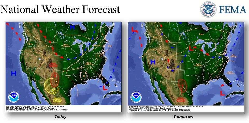
9 National Weather Forecast Day 1 Today Tomorrow

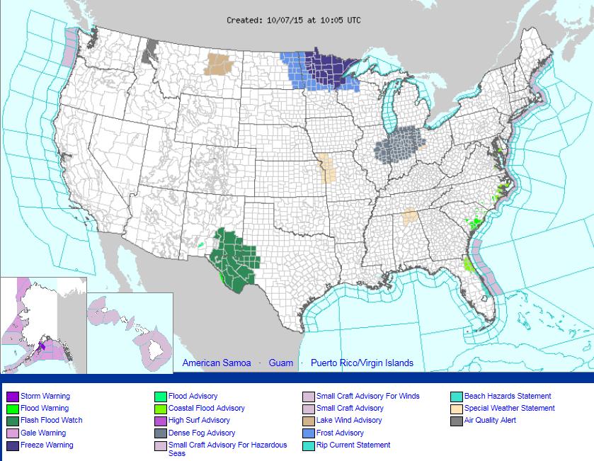
10 Active Watches/Warnings


11 Precipitation Forecast, 1-3 Day Day 1 Day 2 Day 3


12 River Forecasts South Carolina


 Generally correlates to Major Flood Stage Data Extracted from Flood Plain Only 74 miles north of Charleston, SC Population: 1,540")
13 Black River at Kingstree, SC Flood Impacts: 19.7 ft: Flood waters will flow into some homes, extensive flooding will occur along the remainder of the river. Flood waters will affect residential streets in Kingstree and some evacuations may be necessary. Overflow from a canal on East Main Street near the railroad crossing may damage some stores in the area. Highway 52 and 261 closed. 100 Year Flood Plain (50 Square Miles) Generally correlates to Major Flood Stage Data Extracted from Flood Plain Only 74 miles north of Charleston, SC Population: 1,540 Housing Units: 712 Current Record Flood Level: 22.6 Previous Historic Crests at Kingstree, SC 19.8ft (1979), 18ft (1928), 16.1 (1945)
 Generally correlates to Major Flood Stage Data Extracted from Flood Plain Only 74 miles north of Charleston, SC Population: 1,540")

 Generally correlates to Major Flood Stage Data Extracted from Flood Plain Only 42 miles south of Columbia, SC Population:")
14 N. Fork Edisto River at Orangeburg, SC Flood Impacts: 19.7 : The dike along the river in the city of Orangeburg will be topped. Extensive areas of the city including US Highway 301 and the Edisto Memorial Gardens will be flooded. Secondary roads near Orangeburg become flooded at stages above 12 ft. Extensive farmland and lowlands downstream from Orangeburg will be flooded. 100 Year Flood Plain (42 Square Miles) Generally correlates to Major Flood Stage Data Extracted from Flood Plain Only 42 miles south of Columbia, SC Population: 2,132 Housing Units: 1,072 Historic Crests at Orangeburg, SC 14.7ft (1928), 14.3ft (1945), 11.6ft (1971)
 Generally correlates to Major Flood Stage Data Extracted from Flood Plain Only 42 miles south of Columbia, SC Population:")

 Generally correlates to Major Flood Stage Data Extracted from Flood Plain Only 89 miles east of")
15 Lynches River at Effingham, SC Flood Impacts: 16.5 : Water will enter some homes along Roundtree Road and several homes will be isolated along North Old Georgetown, Roundtree, and Bengause Roads near Effingham and New Hope. Flood waters will affect some residential areas up stream near the Sumter County line. 100 Year Flood Plain (38 Square Miles) Generally correlates to Major Flood Stage Data Extracted from Flood Plain Only 89 miles east of Columbia, SC Population: 833 Housing Units: 378 Historic Crests at Effingham, SC 21.2ft (1945), 20ft (1908), 19.4ft (1928)
 Generally correlates to Major Flood Stage Data Extracted from Flood Plain Only 89 miles east of")


16 Waccamaw River near Conway, SC Flood Impacts: 15 ft: Flooding will occur in the Savannah Bluff area, Lees Landing, Pitch Landing, and Riverfront South communities. Flooding also occurs in the basement of the government building at 4th Avenue and Kingston. The Conway Marina will be flooded. FEMA Flood Hazard Layer not available for this location. 24 miles northwest of Myrtle Beach, SC Historic Crests near Conway, SC 19.8ft (1979), 18ft (1928), 16.1 (1945)


17 Hazard Outlook, October


18 Space Weather Past 24 Hours Current Next 24 Hours Space Weather Activity: Moderate None Moderate Geomagnetic Storms G2 None G2 Solar Radiation Storms None None None Radio Blackouts None None None HF Communication Impact Sunspot Activity

19 Disaster Requests & Declarations Declaration Requests in Process Requests APPROVED (since last report) Requests DENIED (since last report) 1 Date Requested 0 0 Navajo Nation EM Toxic Chemical Spill October 2, 2015

20 Disaster Amendments Amendment Effective Date Action Amendment No.1 FEMA-4241-DR-SC October 6, 2015 Adds 3 counties for IA


21 Open Field Offices as of October 7
22 Joint Preliminary Damage Assessments Region State / Location Event IA/PA Number of Counties Requested Complete Start End IV NC SC Flooding September 25, 2015 Flooding IA /14-TBD PA /14-TBD IA /7-TBD PA /7-TBD
23 FEMA Readiness Deployable Teams /Assets Resource Status Total FMC Available Partially Available Deployable Teams/Assets Not Available Detailed, Deployed, Activated Comments Rating Criterion FCO % FDRC % US&R % National IMAT Regional IMAT % N IMAT East-1 deployed to SC % MCOV % IST Red, VA-TF1 & VA-TF2 (Blue) Deployed as Type 1 Task Forces to SC PA-TF1 (Green) NM-TF1 (Red) Personnel shortages Deployed: RIV (Team 1) Deployed to SC; IMAT (Team 2) deployed to SC RVI (Team 2) Deployed to TX RVII Deployed to MO RVIII (Team 1) Deployed to CO RIX (Team 1) Deployed to Guam/CNMI; (Team 2) Deployed to CA RX (Yellow) Partially Mission Capable 10 MCOVs deployed to CA 10 MCOVs deployed to SC 7 unit prep (Thomasville) OFDC Readiness: FCO Green Yellow Red Type Type Type FDRC Green = Available/FMC Yellow = Available/PMC Red = Out-of-Service Blue = Assigned/Deployed Green: 3 avail Yellow: 1-2 avail Red: 0 avail (Individual N-IMAT red if 50% of Section Chiefs and/or Team Leader is unavailable for deployment.) Green: 7 or more avail Yellow: 4-6 teams available Red: > 8 teams deployed/unavailable R-IMAT also red if TL Ops/Log Chief is unavailable & has no qualified replacement Green = % avail Yellow = 60 79% avail Red = 59% or below avail Readiness remains 95%
24 FEMA Readiness National/Regional Teams Resource Status Total FMC Available Partially Available National/Regional Teams Not Available Status NWC % 0 0 Activated Enhanced Watch (24/7) NRCC % 0 44 Not Activated NRCS on Advisory Comments Rating Criterion Green = FMC Yellow = PMC Red = NMC HLT 1 N/A N/A 0 0 Activated DEST Not Activated RRCCs % 0 0 Activated Region IV Level II (day shift) with select ESFs RWCs/MOCs % 0 0 Activated Region IV Enhanced Watch (night shift)

25
Daily Operations Briefing Sunday, May 24, 2015 8:30 a.m. EDT
 Daily Operations Briefing Sunday, May 24, 2015 8:30 a.m. EDT Significant Activity May 23-24 Significant Events: Flooding Southern Plains Tropical Activity: Atlantic Tropical cyclone activity not expected
Daily Operations Briefing Monday, June 20, 2016 8:30 a.m. EDT
 Daily Operations Briefing Monday, June 20, 2016 8:30 a.m. EDT Significant Activity: June 19-20 Significant Events: None Tropical Activity: Atlantic Tropical Storm Danielle formed; no new tropical cyclones
Daily Operations Briefing Saturday, June 25, 2016 8:30 a.m. EDT
 Daily Operations Briefing Saturday, June 25, 2016 8:30 a.m. EDT Significant Activity: June 24-25 Significant Events: Severe Weather / Flooding in WV & VA Tropical Activity: Atlantic Disturbance 1: Low
Daily Operations Briefing Monday, August 10, 2015 8:30 a.m. EDT
 Daily Operations Briefing Monday, August 10, 2015 8:30 a.m. EDT Significant Activity: August 9-10 Significant Events: Typhoon Soudelor Response Tropical Activity: Atlantic: No tropical cyclone activity
Daily Operations Briefing Saturday, September 3, 2016 8:30 a.m. EDT
 Daily Operations Briefing Saturday, September 3, 2016 8:30 a.m. EDT Significant Activity - Sept 2-3 Significant Events: See Tropical Activity Tropical Activity: Atlantic Tropical Storm Gaston; Tropical
Daily Operations Briefing Tuesday, August 11, 2015 8:30 a.m. EDT
 Daily Operations Briefing Tuesday, August 11, 2015 8:30 a.m. EDT Significant Activity: August 10-11 Significant Events: Typhoon Soudelor Response (FINAL) Tropical Activity: Atlantic: No tropical cyclone
Daily Operations Briefing Tuesday, August 20, 2013 8:30 a.m. EDT
 Daily Operations Briefing Tuesday, August 20, 2013 8:30 a.m. EDT 1 Significant Activity: Aug 19 20 Significant Events: None Tropical Activity: Atlantic Tropical cyclone activity is not expected during
River Flood Assessment for northeast SC and southeast NC Saturday, October 17, 2015 1120 AM EDT
 River Flood Assessment for northeast SC and southeast NC Saturday, October 17, 2015 1120 AM EDT National Weather Service Wilmington NC http://weather.gov/ilm Prepared By: Rick Neuherz Richard.Neuherz@noaa.gov
Daily Operations Briefing April 22, 2013 As of 8:30 a.m. EDT
 Daily Operations Briefing April 22, 2013 As of 8:30 a.m. EDT 1 Significant Activity: April 19-22 Significant Events: West Fertilizer Plant Explosion West, TX Heavy rain/flooding Midwest Severe Weather
When Disaster Strikes
 When Disaster Strikes What We Learned from Hurricane Irene Agenda 1 2 3 4 5 Dispatching Overview Disaster Recovery Scenarios Vermont EM Overview Hurricane Irene Questions Page 2 Agenda 1 2 3 4 5 Dispatching
CRS 610 Ventura County Flood Warning System Website
 CRS 610 Ventura County Flood Warning System Website Purpose This document gives instructions and a description of the information available via the Ventura County Watershed Protection District s (VCWPD)
Pennsylvania Flood Safety Awareness Week March 6-10th, 2015
 Pennsylvania Flood Safety Awareness Week March 6-10th, 2015 David J. Nicosia Warning Coordination Meteorologist National Weather Service Binghamton, NY Flooding is a coast to coast threat to the United
MARCH 31, 2010 - WEDNESDAY
 MARCH 31, 2010 - WEDNESDAY GENERAL SESSIONS Buffalo Plane Crash This session will focus on the emergency manager s overview of the Buffalo New York plane crash of Continental 3407. Overview of November
Emergency Management
 LESSON PLAN 5 Be Disaster Safe Learning that there is a system in place and that agencies cooperate to take care of the community s needs during emergencies and disasters reassures and supports students.
Emergency Management is responsible for coordinating the City of Houston s preparation for and response to emergency situations.
 CITY OF HOUSTON Office of Emergency Management October 2004 Emergency Management is responsible for coordinating the City of Houston s preparation for and response to emergency situations. Houston is exposed
Preparing for A Flood
 Preparing for A Flood 1. Know if you are in a flood prone area. 2. Each year, update flood procedures to be followed by your company, employees and tenants: Including Emergency Contacts Evacuation Plans
Interstate 95 is closed from I-26 to I-20 in both directions and is detoured. I-95 will be opened when repairs to these 13 bridges are complete.
 2015 Major Flood Report Statew ide Operations (8:00 AM- REPORT) October 11, 2015 Statewide Summary Interstate I-95: The Contractor has made good progress towards the repair of the substructures of 13 Interstate
Texas Department of Public Safety Texas Division of Emergency Management. Texas State Operations Center
 Texas Department of Public Safety Texas Division of Emergency Management Texas State Operations Center Situation Awareness Brief Saturday, October 26 th 2013 As of 0900 CDT Tropical Weather Outlook Incidents
Texas Department of Public Safety Texas Division of Emergency Management. Texas State Operations Center
 Texas Department of Public Safety Texas Division of Emergency Management Texas State Operations Center Situation Awareness Brief Saturday, July 20 th 2013 As of 0900 CDT Tropical Weather Outlook For the
Challenges. Estimated Damages from 100-Year Flood
 Suffield Suffield is a rural community located along the Massachusetts border. It encompasses about 42.2 square miles and has a population of about 15,735. Suffield s terrain rises from an elevation of
What if Hurricane Sandy made landfall on the SC Coastline???
 What if Hurricane Sandy made landfall on the SC Coastline??? Charlie Kaufman Dorchester County Emergency Management Department Dr. Norm Levine College of Charleston: Lowcountry Hazards Center Background
Town of Amherst Flood Plan Annex
 Town of Amherst Flood Plan Annex The following document is an annex to the Town of Amherst Disaster Plan and is specifically used as a guideline for Flooding events Flood Plans can enable a flexible response
Antecedent Conditions:
 Antecedent Conditions: Record to Near Record Heat occurred across Northeast & North Central Colorado September 2-8. A cold front moved across Northeast Colorado the morning of the 9 th, and deeper subtropical
The Future of Response, Recovery and Reconstitution Capability
 The Future of Response, Recovery and Reconstitution Capability Sheraton Society Hill Hotel, Philadelphia, PA William L. Carwile, III Associate Administrator for Response and Recovery August 25, 2011 Federal
TABLE OF CONTENTS 10. ANNEX D... 10-2
 TABLE OF CONTENTS 10. ANNEX D... 10-2 10.1 PURPOSE...10-2 10.2 SITUATION AND ASSUMPTIONS...10-2 10.2.1 SITUATION...10-2 10.2.2 ASSUMPTIONS...10-2 10.3 GENERAL PROCEDURES AND RESPONSIBILITIES... 10-3 10.3.1
9/13/2013. Emergency Management has jurisdiction over the entire county. Requires an emergency management Director.
 9/13/2013 Florida Statute 252 Emergency Management 2006 Christmas Day Tornado Track 2013 Terra Mar Manufactured Home Park Tornado 1998 Wildfire State Road 11 Volusia County Emergency Management Division
The State Emergency Response Team turns its attention to supporting county emergency response and recovery in the aftermath of Hurricane Charley.
 SITUATION REPORT No. 7 Hurricane CHARLEY The Florida State Emergency Response Team August 14, 2004 Published at 0700 Hours State Emergency Operations Center Level: 1 Operational Period: August 13, 2004
MIAMI-SOUTH FLORIDA National Weather Service Forecast Office http://www.weather.gov/miami
 MIAMI-SOUTH FLORIDA National Weather Service Forecast Office http://www.weather.gov/miami Summer 2015 Weather Summary Wet West and Dry East September 2, 2015: One of the most variable summers in recent
Emergency Management Planning Criteria for Ambulatory Surgical Centers (State Criteria Form)
") Emergency Management Planning Criteria for Ambulatory Surgical Centers (State Criteria Form) FACILITY INFORMATION: FACILITY NAME: FIELD (Company) FAC. TYPE: ASC STATE RULE: 59A-5, F.A.C CONTACT PERSON:
Emergency Management Planning Criteria for Ambulatory Surgical Centers (State Criteria Form) FACILITY INFORMATION: FACILITY NAME: FIELD (Company) FAC. TYPE: ASC STATE RULE: 59A-5, F.A.C CONTACT PERSON:
Multi-Jurisdictional Hazard Mitigation Plan
 Flooding General Flooding is the leading cause of death among all types of natural disasters throughout the United States, with its ability to roll boulders the size of cars, tear out trees, and destroy
City of Salinas Flood Response Preparations
 City of Salinas Flood Response Preparations Winter Preparations Goals for 2015/2016 Community Preparedness in the event of flooding Media cooperation on safety and preparedness, public information sharing
EMERGENCY ACTION PLAN
 EMERGENCY ACTION PLAN INDIAN SPRINGS LAKE ESTATES PROPERTY OWNERS ASSOCIATION WILD INDIAN LAKE DAM Inventory No.: TX04915 Water Right Adjudication: 04416 Prepared April 12, 2010 by ISLEPOA PARTIALLY REVISED
Department of Commerce National Oceanic & Atmospheric Administration National Weather Service
 Department of Commerce National Oceanic & Atmospheric Administration National Weather Service NATIONAL WEATHER SERVICE WESTERN REGION SUPPLEMENT 2-2009 APPLICABLE TO INSTRUCTION NWSI 10-602 May 17, 2013
EMERGENCY MANAGEMENT PLANNING CRITERIA FOR AMBULATORY SURGICAL CENTERS
 EMERGENCY MANAGEMENT PLANNING CRITERIA FOR AMBULATORY SURGICAL CENTERS The following criteria are to be used when developing Comprehensive Emergency Management Plans (CEMP) for all ambulatory surgical
Flood Insurance Guide THE INSURANCE AGENT S ROLE IN PROTECTING HOMEOWNERS
 Flood Insurance Guide THE INSURANCE AGENT S ROLE IN PROTECTING HOMEOWNERS Table of Contents Introduction... 3 Your Clients Need Flood Insurance... 5 For Most of the U.S., Flood Insurance Is Highly Affordable...
South Carolina Child Care Services. Child Care Emergency Plan Template
 South Carolina Child Care Services Child Care Emergency Plan Template South Carolina Department of Social Services regulations require child care facilities to have a plan in place that addresses emergency
Emergency Management Planning Criteria For Residential Treatment Facilities
 Emergency Management Planning Criteria For Residential Treatment Facilities The following minimum criteria are to be used for Comprehensive Emergency Management Plans (CEMP) for Therapeutic Group Homes
CEMP Criteria for Residential Treatment Facilities
 CEMP Criteria for Residential Treatment Facilities Lee County Emergency Management The following minimum criteria are to be used when Comprehensive Emergency Management Plans (CEMP) for all Residential
7) Coastal Storms: Multi-Hazard Analysis for New York City
 Coastal Storms: Multi-Hazard Analysis for New York City") 7) Coastal Storms: Multi-Hazard Analysis for New York City a) Hazard Profile i) Hazard Description Coastal storms, including nor'easters, tropical storms, and hurricanes, can and do affect New York City.
7) Coastal Storms: Multi-Hazard Analysis for New York City a) Hazard Profile i) Hazard Description Coastal storms, including nor'easters, tropical storms, and hurricanes, can and do affect New York City.
Follow That Hurricane!
 Discover Your World With NOAA Follow That Hurricane! What You Will Do Devastating damage expected A most Track a hurricane on the same powerful hurricane with unprecedented type of chart used at the strength
Knox Andress, RN, FAEN Designated Regional Coordinator Louisiana Region 7 Hospital Preparedness LSU Health Shreveport Louisiana Poison Center
 Knox Andress, RN, FAEN Designated Regional Coordinator Louisiana Region 7 Hospital Preparedness LSU Health Shreveport Louisiana Poison Center To know where you re going you ve got to know where you ve
SECTION 3 COMMUNITY PROFILE. Geography and the Environment
 SECTION 3 This section of the Plan provides a general overview of New Hanover County and its incorporated municipal jurisdictions. This information has been updated to reflect the community profile for
Flood Protection Tips
 Flood Protection Tips Information About Floodplains and Flood Prevention What is a floodplain? Floodplains serve many useful purposes, and those that are preserved in their natural or nearly natural state
CROSS-REFERENCE FOR COMPREHENSIVE EMERGENCY MANAGEMENT PLAN RESIDENTIAL TREATMENT CENTERS FOR CHILDREN AND ADOLESCENTS
 CROSS-REFERENCE FOR COMPREHENSIVE EMERGENCY MANAGEMENT PLAN RESIDENTIAL TREATMENT CENTERS FOR CHILDREN AND ADOLESCENTS (Based upon AHCA Criteria dated July 2006) The document below is the cross-reference
Our Community Partners For Emergency Assistance
 Our Community Partners For Emergency Assistance Martin County Community Services 435 S.E. Flagler Avenue Health & Human Services (772) 288-5785 Administration (772) 288-5434/5901 Veterans Services (772)
NWS Melbourne Flood Briefing for Event Ending Today
 NWS Melbourne Flood Briefing for Event Ending Today Saturday March 6, 2010 900 AM Scott Spratt; Warning Coordination Meteorologist TRAINING SCENARIO FOR DISASTER RESISTANT COMMUNITIES GROUP TRAINING SCENARIO
AMBULATORY SURGICAL CENTERS (Based upon AHCA Form # 3130-2003 JUL 94)
") (Based upon AHCA Form # 3130-2003 JUL 94) The document below is the cross-reference used by Palm Beach County Division of Emergency Management for the annual review and re-certification of your CEMP. Review
(Based upon AHCA Form # 3130-2003 JUL 94) The document below is the cross-reference used by Palm Beach County Division of Emergency Management for the annual review and re-certification of your CEMP. Review
ESF 14. Long-Term Community Recovery
 1. Purpose This annex provides an overview of the general process to be followed in recovering from the economic results of a natural disaster or other major emergency that may impact Coos County. It outlines
HURRICANE EVACUATION GUIDE
 booklet-final 6/30/00 9:41 AM Page 1 E M E R G E N C Y P R E P A R E D N E S S HURRICANE EVACUATION GUIDE Vital information you need to know in case of a hurricane evacuation. Information brought to you
Small Dam Hazard Assessment Inventory
 Small Dam Hazard Assessment Inventory What would happen if your dam were to fail? This is a question that most dam owners hope they will never have to answer. However it is a question you, as a responsible
Infrastructure for Adapting to Climate Change Environmental Law Forum April 10, 2014. 2014 O Brien & Gere
 Infrastructure for Adapting to Climate Change Environmental Law Forum April 10, 2014 1 Agenda Lessons Learned from Superstorm Sandy What are Northeast States Doing About It? State of our Power Grid Role
North Carolina Emergency Management
 North Carolina Emergency Management North Carolina Incidents North Carolina Incidents Primary mission is consequence management Must be prepared to: Search and Rescue Provide Mass Care Protect Life and
El Nino in the OC. Orange County Sheriff s Department Emergency Management Division
 El Nino in the OC Orange County Sheriff s Department Emergency Management Division The mission of the Orange County Sheriff s Department s Emergency Management Division is to promote, facilitate, and support
The City of Ottawa Flood Hazards
 The City of Ottawa Flood Hazards The City of Ottawa is located in North Central LaSalle County, approximately 45 miles West of Joliet and 90 miles South of Rockford. The primary water course and sources
Town of Warwick, Village of Florida, Village of Greenwood Lake and Village of Warwick MULTI JURISIDICTIONAL, MULTI HAZARD MITIGATION PLAN DRAFT
 Town of Warwick, Village of Florida, Village of Greenwood Lake and Village of Warwick MULTI JURISIDICTIONAL, MULTI HAZARD MITIGATION PLAN DRAFT Appendix B Historical Hazard Documentation Rev #0 May 2013
Simple Tabletop Exercise, Interdependency Natural Disaster Scenario Scenario #8 Facilitator s Guide
 Simple Tabletop Exercise, Interdependency Natural Disaster Scenario Scenario #8 Facilitator s Guide Scenario Summary Background: It is March in Zenith City and the residents are experiencing a cold spring.
AMBULATORY SURGICAL CENTERS
 AMBULATORY SURGICAL CENTERS STATUTE RULE CRITERIA Current until changed by State Legislature or AHCA Hospitals and Ambulatory Surgical Centers Statutory Reference 3 395.1055 (1)(c), Florida Statutes Rules
DISCOVER AQ OUTLOOK Thursday January 31, 2013
 DISCOVER AQ OUTLOOK Thursday January 31, 2013 PODEX coastal leg (LA) Oxnard NWS forecasted narrow patch of stratus within 50 miles of the coast, but the main lower level cloud deck would be out past 125+
HURRICANE FRANCES BRIEFING SHEET As of 4:00 p.m., September 2, 2004
 Jeb Bush Governor THE STATE OF FLORIDA State Emergency Response Team www.floridadisaster.org Craig Fugate State Coordinating Officer FOR IMMEDIATE RELEASE-REVISED CONTACT: Public Information-ESF14 September
MONTGOMERY COUNTY, KANSAS EMERGENCY OPERATIONS PLAN. ESF14-Long Term Community Recovery
 MONTGOMERY COUNTY, KANSAS EMERGENCY OPERATIONS PLAN ESF14-Long Term Community Recovery Planning Team Support Agency Coffeyville Public Works Independence Public Works Montgomery County Public Works 1/15/2009
E Functional Annex Damage Assessment
 E Functional Annex Damage Assessment Approved (September 14, 2004) This page left blank intentionally Table of Contents 1 Purpose... 3 2 Situation and Assumptions... 3 2.1 Situation... 3 2.2 Assumptions...
Southern AER Atmospheric Education Resource
 Southern AER Atmospheric Education Resource Vol. 9 No. 5 Spring 2003 Editor: Lauren Bell In this issue: g Climate Creations exploring mother nature s remote control for weather and Climate. g Crazy Climate
Improved Warnings for Natural Hazards: A Prototype System for Southern California
 Improved Warnings for Natural Hazards: A Prototype System for Southern California Yehuda Bock Research Geodesist Scripps Institution of Oceanography University of California San Diego, La Jolla, Calif.
North Carolina Emergency Management. Preparedness, Response & Long-Term Recovery
 North Carolina Emergency Management Preparedness, Response & Long-Term Recovery Status of Recovery from Hurricane Irene Individual Assistance 35 counties declared 29,936 people registered $21,182,252 disbursed
EMERGENCY MANAGEMENT PLANNING & COMPLIANCE REVIEW CRITERIA FOR NURSING HOMES [FL RULE CHAPTER 59A-4.126 F.A.C]
![EMERGENCY MANAGEMENT PLANNING & COMPLIANCE REVIEW CRITERIA FOR NURSING HOMES [FL RULE CHAPTER 59A-4.126 F.A.C]](/thumbs/33/16547086.jpg "EMERGENCY MANAGEMENT PLANNING & COMPLIANCE REVIEW CRITERIA FOR NURSING HOMES [FL RULE CHAPTER 59A-4.126 F.A.C]") EMERGENCY MANAGEMENT PLANNING & COMPLIANCE REVIEW CRITERIA FOR NURSING HOMES [FL RULE CHAPTER 59A-4.126 F.A.C] Notice: Facilities must submit their plans with the appropriate page numbers shown in the
EMERGENCY MANAGEMENT PLANNING & COMPLIANCE REVIEW CRITERIA FOR NURSING HOMES [FL RULE CHAPTER 59A-4.126 F.A.C] Notice: Facilities must submit their plans with the appropriate page numbers shown in the
Disaster Risk Reduction through people centered National Multi-hazard Early Warning System in the context of Maldives
 Disaster Risk Reduction through people centered National Multi-hazard Early Warning System in the context of Maldives Abdul Muhusin, Deputy Director Department of Meteorology, Maldives Fourth Technical
Crawford County Health Department. Donna Milam, BS, LEHP Director of Environmental Health and Emergency Preparedness
 Crawford County Health Department Donna Milam, BS, LEHP Director of Environmental Health and Emergency Preparedness Flash Flooding and River Flooding in June 2008 2 Rivers: Wabash on East and Embarras
TROPICAL STORM ALLISON. Prepared by: John P. Ivey, PE, CFM Halff Associates, Inc. ASCE
 TROPICAL STORM ALLISON June 5-9, 5 2001 Prepared by: John P. Ivey, PE, CFM Halff Associates, Inc. ASCE Spring 2002 Meeting Arlington, Texas March 27-30, 2002 Tropical Storm Allison (TSA) The most extensive
Homeland Security Plan for Iowa State University Extension Field Offices
 Homeland Security Plan for Iowa State University Extension Field Offices Homeland security covers natural disaster events such as a flood, drought, or winter storm, as well as terrorist events from a physical,
CITY OF KENT, WASHINGTON COMPREHENSIVE EMERGENCY MANAGEMENT PLAN APPENDIX 3 REFERENCES
 CITY OF KENT, WASHINGTON COMPREHENSIVE EMERGENCY MANAGEMENT PLAN APPENDIX 3 REFERENCES The City of Kent Comprehensive Emergency Management Plan was developed and is maintained pursuant to, but not limited
Situation Report #2 Hurricane Irene impact on Turks and Caicos Islands and The Bahamas (as at 5:00 p.m.)
") Situation Report #2 Hurricane Irene impact on Turks and Caicos Islands and The Bahamas (as at 5:00 p.m.) Hurricane Irene impacting the Turks and Caicos Islands and Bahamas Message: Hurricane Irene a Category
Situation Report #2 Hurricane Irene impact on Turks and Caicos Islands and The Bahamas (as at 5:00 p.m.) Hurricane Irene impacting the Turks and Caicos Islands and Bahamas Message: Hurricane Irene a Category
Emergency Management Planning Criteria for Nursing Home Facilities (Criteria)
") Emergency Management Planning Criteria for Nursing Home Facilities (Criteria) The following minimum criteria are to be used when developing Comprehensive Emergency Management Plans (CEMP) for all Nursing
Emergency Management Planning Criteria for Nursing Home Facilities (Criteria) The following minimum criteria are to be used when developing Comprehensive Emergency Management Plans (CEMP) for all Nursing
A National Perspective on Hurricane Evacuation Traffic Operation and Management:
 A National Perspective on Hurricane Evacuation Traffic Operation and Management: Policies, Practices, Needs, and Research Brian Wolshon Dept. of Civil and Env.. Engineering LSU HURRICANE CENTER Addressing
MEDICAL PLANNING MAJOR EVENTS
 NATIONAL DISASTER LIFE SUPPORT EDUCATIONAL CONSORTIUM ANNUAL MEETING MEDICAL PLANNING MAJOR EVENTS Cynthia Davidson Louisiana Region 1 Hospital Designated Regional Coordinator EMERGENCY MANAGEMENT 1970
ALBUQUERQUE EMERGENCY OPERATIONS PLAN ANNEX 8 DAMAGE ASSESSMENT AND REPORTING
 ALBUQUERQUE EMERGENCY OPERATIONS PLAN ANNEX 8 DAMAGE ASSESSMENT AND REPORTING PRIMARY RESPONSIBILITY Albuquerque City and Bernalillo County Government SECONDARY RESPONSIBILITY Department of Public Safety,
Floods are too much water on normally dry land. Rivers can flood after heavy rain has fallen over a long period of time. River flooding can last
 Floods are too much water on normally dry land. Rivers can flood after heavy rain has fallen over a long period of time. River flooding can last weeks or longer. River floods usually occur slowly enough
Franklin County Emergency Management Department (FCEMD) All County Emergency Response Team (CERT) Agencies. Table of Contents
 All County Emergency Response Team (CERT) Agencies. Table of Contents") Concept of Operations Lead Agency Support Agency Standard Operating Procedures Emergency Operations Center (EOC) Franklin County Emergency Management Department (FCEMD) All County Emergency Response Team
Concept of Operations Lead Agency Support Agency Standard Operating Procedures Emergency Operations Center (EOC) Franklin County Emergency Management Department (FCEMD) All County Emergency Response Team
Volume 1-2 Technical Data Report Apalachee Region CHAPTER IV Regional Population and Vulnerability Analysis
 Volume 1-2 Technical Data Report Apalachee Region CHAPTER IV Regional Population and Vulnerability Analysis APPENDIX IV-H Liberty County Critical Facilities and Vulnerability Analysis Statewide Regional
ESCAMBIA COUNTY FLOOD RECOVERY: 1- YEAR ANNIVERSARY REPORT
 Joy D. Blackmon, P.E. Director, County Engineer Public Works Department ESCAMBIA COUNTY FLOOD RECOVERY: 1- YEAR ANNIVERSARY REPORT EXECUTIVE SUMMARY One year after the devastating April 2014 floods hit
Weather Briefing for Southeast Texas October 24 th, 2015
 Weather Briefing for Southeast Texas October 24 th, 2015 Dangerous Flash Flood Event Saturday through Sunday 8:16 AM Overview Ongoing: record deep moisture in place, elevated seas, rip currents, high surf,
Standard Operating Procedures for Flood Preparation and Response
 Standard Operating Procedures for Flood Preparation and Response General Discussion Hurricanes, tropical storms and intense thunderstorms support a conclusion that more severe flooding conditions than
Volume 1-2 Technical Data Report Apalachee Region CHAPTER IV Regional Population and Vulnerability Analysis
 Volume 1-2 Technical Data Report Apalachee Region CHAPTER IV Regional Population and Vulnerability Analysis APPENDIX IV-F Jefferson County Critical Facilities and Vulnerability Analysis Statewide Regional
Emergency Management in Los Angeles County
 Emergency Management in Los Angeles County Jeff L. Reeb AFN Coordinator Los Angeles County Office of Emergency Management Office of Emergency Management OEM is responsible for organizing and directing
2015 CRS Community Outreach. City of Folly Beach, South Carolina Flood Plain Management Offices PO Box 48 Folly Beach, SC 29439 843-588-2447 ext 1838
 City of Folly Beach, South Carolina Flood Plain Management Offices PO Box 48 Folly Beach, SC 29439 843-588-2447 ext 1838 The dark line around this map delineates the extent of the Special Flood Hazard
Probability Magnitude/Severity Warning Time Duration CPRI Flood 3.25 2.88 2.50 3.13 3.01
 3.7.8 FLOOD Probability Magnitude/Severity Warning Time Duration CPRI Flood 3.25 2.88 2.50 3.13 3.01 Description Flooding is the most frequent and costly natural hazard in the United States. During the
Emergency Management Planning Criteria for Assisted Living Facilities (State Criteria Form)
") Emergency Management Planning Criteria for Assisted Living Facilities (State Criteria Form) FACILITY INFORMATION: FACILITY NAME: FIELD (ALF Company) ST. LIC. NO.: FIELD (Lic. #) FAC. TYPE: ALF STATE RULE:
Emergency Management Planning Criteria for Assisted Living Facilities (State Criteria Form) FACILITY INFORMATION: FACILITY NAME: FIELD (ALF Company) ST. LIC. NO.: FIELD (Lic. #) FAC. TYPE: ALF STATE RULE:
NURSING HOME STATUE RULE CRITERIA
 NURSING HOME STATUE RULE CRITERIA Page 1 of 11 Nursing Homes Statutory Reference 8 400.23 (2)(g), Florida Statutes Rules; criteria; Nursing Home Advisory Committee; evaluation and rating system; fee for
CITY OF HUMBLE OFFICE OF EMERGENCY MANAGEMENT. 110 W. Main St. Humble, Tx. 77338 ph. 281 446 4928 Email; cjohnson@cityofhmble.net
 CITY OF HUMBLE OFFICE OF EMERGENCY MANAGEMENT 110 W. Main St. Humble, Tx. 77338 ph. 281 446 4928 Email; cjohnson@cityofhmble.net Emergency Management Director: Mayor Donnie McMannes Emergency Management
HAZARD VULNERABILITY & RISK ASSESSMENT
 Hazard Vulnerability Analysis Purpose and Scope A Hazard Vulnerability Analysis (HVA) evaluates risk associated with a specific hazard. During this analysis, the hazard is evaluated for its probability
Veterinary Practice Emergency Plan Instructions
 I. PURPOSE The purpose of this plan is to protect the health and well being of patients, employees and clients of (your practice name here) during times of disaster. In addition, this plan is designed
Climate Trends In New England and Its Impact on Storm Behavior; Riverine and Coastal Flood Impacts
 2 ND ANNUAL CAPE COASTAL CONFERENCE JUNE 6 Linking Science with Local Solutions and Decision-Making Climate Trends In New England and Its Impact on Storm Behavior; Riverine and Coastal Flood Impacts David
URGENT - WEATHER MESSAGE NATIONAL WEATHER SERVICE MELBOURNE FL 402 AM EST MON JAN 6 2014
 URGENT - WEATHER MESSAGE...FREEZE AND HARD FREEZE WARNINGS IN EFFECT FOR PORTIONS OF EAST CENTRAL FLORIDA TONIGHT......LAKE WIND ADVISORY IN EFFECT FOR PORTIONS OF EAST CENTRAL FLORIDA THIS AFTERNOON...
Hurricanes. Characteristics of a Hurricane
 Hurricanes Readings: A&B Ch. 12 Topics 1. Characteristics 2. Location 3. Structure 4. Development a. Tropical Disturbance b. Tropical Depression c. Tropical Storm d. Hurricane e. Influences f. Path g.
Emergency Support Function 6 Mass Care and Human Services
 ESF Coordinator: Grant County Emergency Management Primary Agencies for: American Red Cross Apple Valley Chapter Grant County Emergency Management Support Agencies: Emergency Support Function 6 Mass Care
Full Campus Evacuations During Large Scale Events
 Full Campus Evacuations During Large Scale Events LBCC s Incident Commander, City of Albany, Linn County, or Benton County EOC may order an evacuation for emergency purposes. LBCC main campus is within
Cabarrus County Floodplain Information TABLE OF CONTENTS
 Cabarrus County Floodplain Information TABLE OF CONTENTS Flood Hazard What is 100-year flood? Does Cabarrus County flood? Flood Safety How do I protect my property from flood damage? Is there anything
Flood Risk Management
 Flood Risk Management Value of Flood Risk Management Every year floods sweep through communities across the United States taking lives, destroying property, shutting down businesses, harming the environment
Flood Risk Management
 Flood Risk Management Value of Flood Risk Management Value to Individuals and Communities Every year floods sweep through communities across the United States taking lives, destroying property, shutting
SITE SPECIFIC WEATHER ANALYSIS REPORT
 SAMPLE FLOOD ANALYSIS REPORT SITE SPECIFIC WEATHER ANALYSIS REPORT PREPARED FOR: Law Offices of Oliver Wendell Douglas Oliver Wendell Douglas PREPARED BY: November 29, 2007 CASE REFERENCE: Arnold Ziffel
Georgia College Emergency Notification System Activation Protocols
 Georgia College Emergency Notification System Activation Protocols Georgia College & State University Office of Emergency Preparedness and Occupational Safety December 2013 I. Introduction and Purpose