Determining the Roughness Angles of Surfaces Using Laser Scanners
|
|
|
- Hubert Baldwin
- 10 years ago
- Views:
Transcription
1 , TURKEY Keywords: Laser Scanner, 3D Model, DEM, Geology, Surface Roughness SUMMARY Terrestrial laser scanners are measuring instruments providing the detailed 3D object geometry directly and fastly. The most important advantage that laser scanners provide is the ability of getting the detailed 3D model of the complex objects very quickly with respect to other measuring methods. In this study, it is aimed to measure and define mathematically the roughness degree of the surfaces of rock pieces that are obtained as the result of breaking experiment. After the visual inspection of the surfaces, it was decided that the most convenient measuring method is scanning the surfaces in terms of complexity. The aim of the study is to measure the roughness angles, which are used to determine roughness degree effects as an important factor on the cutting resistance, faster and faithful. To achieve this goal; laser scanner was used as the measuring device, because of their ability of providing detailed 3D object geometry directly and fast. Nextengine 3D Desktop Laser Scanner was used in this study. Nextengine 3D Desktop Laser Scanner is a low cost scanning system which provides high precision with fast measuring ability. It is a triangulation based scanner. The objects that were used in this study are two opposed half pieces of a coring. The coring was broken under load test. Each pieces of the coring was laid on the tray of the system, which is approximately 15 cm from the device. This tray has the ability to rotate the object automatically to enable to scan all sides of the object. The acquired point clouds were filtered and noise reduction was applied. After that surface models of the both object were created using triangulated irregular network. Opposed Cross sections were created on both surfaces. New points that can represent these cross sections were generated automatically. These points were split up to cross sections and sorted according to their coordinate values. For each cross section curve equations were generated by using Matlab Curve Fitting Toolbox. Since they could not be mathematically formulated shape preserving fitting was used. After these fitting, slopes for certain intervals were calculated on these curves. Roughness angles were calculated from these slope values. Finally maximum, minimum and average values of negative and positive angles were summarized and roughness degree of the coring was determined. TS05I - Spatial Information Processing I 1/10

2 , TURKEY 1. INTRODUCTION Terrestrial laser scanners are measuring devices that has the capability of obtaining the detailed 3D object geometry directly and fastly. Laser scanners should not be considered as the replacing technology of the other methods like photogrammetry or classical geodetic measurements by itself, but it is a complementary and effective method when it is used together with the other methods. The most important advantage of laser scanners is the capability of measuring and modeling the complex objects and surfaces as highly detailed with respect to classical methods. In this study, it is aimed to measure the roughness degree of the surfaces of rock pieces and define the roughness angles. After visual inspection of the rock surfaces that were gathered at the end of breaking experiment, it was decided to use laser scanner for modeling the surfaces. Nextengine 3D Desktop scanner was used for the study. Nextengine 3D desktop scanner is a low-cost scanner which provides precise 3D point cloud fastly. This paper is organised as 4 sections. The first part is about the principles and tehcnical features of terrestrial laser scanner used at the study. At the second part, measuring and modeling steps were discussed. The third part covers the followed steps in order to determine the surface roughness angles and results. Finally, results, problems and solution recommendations are discussed at the fouth part. 2. OPTIC LASER SCANNING In recent years, by the rapid development at computer technology, graphic processors of personal computers has strengthen and as result of this, the use of 3D modelling has grown up in both scientific area and among the end users. Together with the increasing demand to 3D models, high cost of the commercial laser scanners and the difficulty of processing the data from these devices has lead the development of low-cost 3D laser scanning systems. The main principle of optical scanners is triangluation. According to the triangulation principle, it is possible to calculate the 3D object coordinate (c) if the distance between camera and laser source (d) and two angles (α), (β) (Figure 1: 3D object scanning by triangulation method) of triangle are known. Magnitude of (γ) angle effects the depth resolution. If the angle increases, depth resolution increases [Zagorchev,2006]. 2/10

3 Figure 1: 3D object scanning by triangulation method In this study, Nextengine 3D Desktop scanner was used (Figure 2). Nextengine 3D desktop scanner is a low-cost scanner which provides precise 3D point cloud fastly. Accuracy of the system is specified by the manifacturer as ±0.127 mm for macro mode and ±0.328 mm for wide mode. 3. SCANNING AND MODELLING The rock pieces were placed on the rotating tray which is about 15cm away from the scanner. It is important that the whole object should place in the view of the camera of the scanner. ScanStudio HD software is used to control the scanner. The tray has the capability of rotating 360 o and rotates the object by the predefined angles. The alignment of the point clouds are done automatically by the ScanStudio. It should be taken care of not to change the position of the both scanner and the object. If this situation occurs, the software cannot carry out the automatic alignment process. In this kind of problem, one can align the point clouds manually by using the alignment tool of the software. At the end of the scanning, 3D model of the rock pieces were obtained and saved as vrl and exported to Geomagic Studio software to carry out some filtering processes. First of all, a low-level noise reduction was applied to the model and then point number was reduced by applying curvature sample method. 3/10

4 Figure 2: Nextengine 3D desktop scanner Figure 3: 3D Model Curvature sample method preserves the detailes by reducing the point number at flat areas while preserving the number of points at non-flat parts. After post-processing steps, mesh model was generated from point cloud. The final model stil had some ocluded areas due to the viewing angle and lack of the light during the scanning. These occluded areas should be filled by choosing the appropriate enterpolation method of the software. Since the roughnesses of the surfaces are matters in this study, curvature-based method was choosen in order to preserve the curves. After getting the full 3D object model, cross-sections on the surface are taken with 2 mm interval in order to obtain the breaking angles (Figure 3 and Figure 4). CAD illustrations of these cross sections are given in Figure 5. 4/10

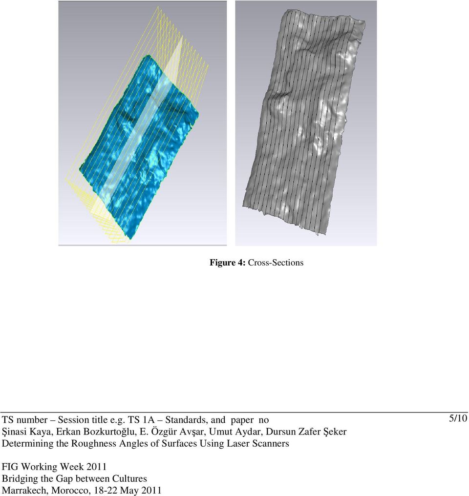
5 Figure 4: Cross-Sections 5/10
6 Figure 5: CAD illustration 4. DETERMINING THE SURFACE ROUGHNESS In this section, calculating the roughness angles on surface was carried out. For this purpose MATLAB software s Curve Fitting Toolbox was used. By using the curve fitting toolbox, the first derivatives with 1 mm interval was calculated on curves. First derivatives give the slope of the curve on that point, so the breaking angle can be calculated as the inverse of the slope. Number of cross sections, number of point on each section and length of sections are given in Table 1. The maximum and minumum angles in both negative and positive and avarage of the angles were calculated and given in Table 2 for the all 17 cross-sections. Cross-Section-Slope Graph of the first cross-section is given in Figure 6. Table 1: Cross-Sections and Number of Points Cross section Number of point Length (mm) Cross section Number of point Length (mm) Cross section Number of point Length (mm) /10

7 Figure 6: Cross-Section-Slope Graph Cross-Section i breaking angle graph Table 2: Cross sections and breaking angles Cross-Sec. No Max Min Max Min Absolute /10

8 Average In order to compare the obtained angles with the Description of Discontinuities and JRC standarts, curve fitting and calculation of the breaking angles steps for aforementioned standarts were carried out, as well (Table 3). The geometric relationship between cross sections and DOD standards are illustrated in Figure 7. Figure 7: Obtained cross-section for DOD Table 3: DOD standarts Cross-Sec. No Max Min Max Min Absolute RESULTS AND RECOMMENDATIONS 8/10

9 This study presented that terrestrial laser scanners can be effectively used in terms of accuracy and time to precisely calculate roughness angles of surfaces. These kinds of desktop scanners for sample drilling cores are higly suitable, but for the real case studies terrestrial laser scanners should be used. The proposed methodology will give effective and quick results for the period of collecting and processing the data. REFERENCES Akça D. Grün A. Breuckmann B., and Lahanier C., 2007, High Definition 3D-Scanning of Arts Objects and Paintings, Optical 3D Measurement Techniques VIII, July 9-12, Zurich, Switzerland Duran Z., Aydar U. 2009, Nippur Uzunluk Ölçme Aletinin 3b Modellenmesi Ve Görselleştirilmesi, Türkiye Ulusal Fotogrametri ve Uzaktan Algılama Birliği V. Teknik Sempozyumu, Şubat 4-5, Ankara, Türkiye (in Turkish). K.Gümüş, H. Erkaya, 2007, Mühendislik Uygulamalarında Kullanılan Yersel Lazer Tarayıcı Sistemler, TMMOB Harita ve Kadastro Mühendisleri Odası 11. Türkiye Harita Bilimsel ve Teknik Kurultayı, 2 6 Nisan 2007, Ankara (in Turkish). O. Akyol, Z. Duran, U. Aydar, 2011 Düşük Maliyetli Optik Tarayıcı Sistem Tasarım Örneği, Türkiye Ulusal Fotogrametri ve Uzaktan Algılama Birliği VI. Teknik Sempozyumu, Şubat 2011, Antalya (in Turkish). Reshetyuk, Y Investigation and calibration of pulsed time-of-flight terrestrial laser scanners, Department of Transport and Economics Division of Geodesy Stockholm. Zagorchev, L., Goshtasby, A. 2006: A paintbrush lazer range scanner. Computer Vision and Image Understanding 101. CONTACTS Şinasi Kaya, ITU, Istanbul Technical University, Department of Geomatic Engineering, Maslak, Istanbul, (kaya,avsarem, aydaru,seker)@itu.edu.tr Erkan Bozkurtoğlu, İTÜ, Istanbul Technical University, Department of Geology Engineering, Maslak, Istanbul, Turkey [email protected] E. Özgür Avşar, ITU, Istanbul Technical University, Department of Geomatic Engineering, Maslak, Istanbul, Turkey (kaya,avsarem, aydaru,seker)@itu.edu.tr 9/10

10 Umut Aydar, ITU, Istanbul Technical University, Department of Geomatic Engineering, Maslak, Istanbul, Turkey (kaya,avsarem, Dursun Zafer Şeker, ITU, Istanbul Technical University, Department of Geomatic Engineering, Maslak, Istanbul, Turkey (kaya,avsarem, 10/10

DAMAGED ROAD TUNNEL LASER SCANNER SURVEY
 University of Brescia - ITALY DAMAGED ROAD TUNNEL LASER SCANNER SURVEY Prof. Giorgio Vassena [email protected] WORKFLOW - Demand analysis - Instruments choice - On field operations planning - Laser
How To Test The Geometric Accuracy Of A Laser Scanner Model
 International Journal of the Physical Sciences Vol. 6(28), pp. 6529-6536, 9 November, 2011 Available online at http://www.academicjournals.org/ijps DOI: 10.5897/IJPS11.344 ISSN 1992-1950 2011 Academic
Optical Digitizing by ATOS for Press Parts and Tools
 Optical Digitizing by ATOS for Press Parts and Tools Konstantin Galanulis, Carsten Reich, Jan Thesing, Detlef Winter GOM Gesellschaft für Optische Messtechnik mbh, Mittelweg 7, 38106 Braunschweig, Germany
Application Example: Reverse Engineering
 Application Example: Reverse Engineering Use of optical measuring technology in the ceramics industry Measuring system: ATOS Keywords: Reverse Engineering, Tool and Moldmaking, Quality Assurance, Ceramic
Pipeline External Corrosion Analysis Using a 3D Laser Scanner
 Pipeline Technology Conference 2013 Pipeline External Corrosion Analysis Using a 3D Laser Scanner Pierre-Hugues ALLARD, Charles MONY Creaform, www.creaform3d.com 5825 rue St-Georges, Lévis (QC), Canada,
HIGH AND LOW RESOLUTION TEXTURED MODELS OF COMPLEX ARCHITECTURAL SURFACES
 HIGH AND LOW RESOLUTION TEXTURED MODELS OF COMPLEX ARCHITECTURAL SURFACES E. K. Stathopoulou a, A. Valanis a, J. L. Lerma b, A. Georgopoulos a a Laboratory of Photogrammetry, National Technical University
Glass coloured glass may pick up on scan. Top right of screen tabs: these tabs will relocate lost windows.
 Artec 3D scanner Instructions for Medium Handheld (MH) Scanner Scanning Conditions: Objects/surfaces that don t scan well: Black or shiny objects and objects with sharp edges or points, hair, glass, transparent
3D Scanner using Line Laser. 1. Introduction. 2. Theory
 . Introduction 3D Scanner using Line Laser Di Lu Electrical, Computer, and Systems Engineering Rensselaer Polytechnic Institute The goal of 3D reconstruction is to recover the 3D properties of a geometric
Differentiation of 3D scanners and their positioning method when applied to pipeline integrity
 11th European Conference on Non-Destructive Testing (ECNDT 2014), October 6-10, 2014, Prague, Czech Republic More Info at Open Access Database www.ndt.net/?id=16317 Differentiation of 3D scanners and their
MULTIPURPOSE USE OF ORTHOPHOTO MAPS FORMING BASIS TO DIGITAL CADASTRE DATA AND THE VISION OF THE GENERAL DIRECTORATE OF LAND REGISTRY AND CADASTRE
 MULTIPURPOSE USE OF ORTHOPHOTO MAPS FORMING BASIS TO DIGITAL CADASTRE DATA AND THE VISION OF THE GENERAL DIRECTORATE OF LAND REGISTRY AND CADASTRE E.ÖZER, H.TUNA, F.Ç.ACAR, B.ERKEK, S.BAKICI General Directorate
Application Report. Propeller Blade Inspection Station
 34935 SE Douglas Street, Suite, Snoqualmie, WA 9874 Ph: 425-396-5577 Fax: 425-396-586 Application Report Propeller Blade Inspection Station Prepared By Kyle Johnston, Ph. D. Metron Systems Inc.5.5 3 2.5
High speed 3D capture for Configuration Management DOE SBIR Phase II Paul Banks [email protected]
 High speed 3D capture for Configuration Management DOE SBIR Phase II Paul Banks [email protected] Advanced Methods for Manufacturing Workshop September 29, 2015 1 TetraVue does high resolution 3D
A Simple Guide To Understanding 3D Scanning Technologies
 A Simple Guide To Understanding 3D Scanning Technologies First Edition www.lmi3d.com Table of Contents Introduction At LMI Technologies, solving complex problems in a simple way is the philosophy that
HIGH DEFINITION 3D-SCANNING OF ARTS OBJECTS AND PAINTINGS
 Structured Light and Laser Scanning 50 HIGH DEFINITION 3D-SCANNING OF ARTS OBJECTS AND PAINTINGS Devrim AKÇA 1, Armin GRÜN 1, Bernd BREUCKMANN 2, and Christian LAHANIER 3 1 Institute of Geodesy and Photogrammetry,
VERSATILE AND EASY-TO-USE 3D LASER SCANNERS > >
 VERSATILE AND EASY-TO-USE 3D LASER SCANNERS > > A WORLD OF APPLICATIONS 3D Systems, producers of the industry s fastest, easiest-to-use and most versatile 3D scanners, makes 3D scanning ideal for a wide
3D SCANNING SOLUTION FOR PIPELINE INTEGRIT Y ASSESSMENT!
 NDT SOLUTIONS 3D SCANNING SOLUTION FOR PIPELINE INTEGRIT Y ASSESSMENT! CODE-COMPLIAN T PORTABLE 3D MEASUREMENT SOLUTIONS Pipeline operators and NDT service companies must deal with increasing pressure
Product and Service Catalog 2009 Direct Dimensions, Inc.
 Product and Service Catalog 2009 LASER SCANNERS... 4 SURPHASER LASER SCANNER... 4 DIMENSIONAL IMAGING DI3D... 4 VIALUX Z-SNAPPER 3D CAMERA... 4 KONICA MINOLTA RANGE7 3D DIGITIZER... 4 KONICA MINOLTA VIVID
The Role and Effect of Private Sector on Turkish Cadastral System
 The Role and Effect of Private Sector on Turkish Cadastral System Okan YILDIZ 1, Yakup Emre ÇORUHLU 2, Osman DEMİR 3, Merve Özlem MURAT 4 1,2,3,4 Karadeniz Technical University, Faculty of Engineering,
Types of 3D Scanners and 3D Scanning Technologies.
 Types of 3D Scanners and 3D Scanning Technologies. There are many types of 3D scanners and 3D scanning technologies. Some are ideal for short range scanning while others are better suited for mid or long
VERSATILE AND EASY-TO-USE 3D LASER SCANNERS > >
 VERSATILE AND EASY-TO-USE 3D LASER SCANNERS > > A WORLD OF APPLICATIONS Z Corporation, producers of the industry s fastest, easiest-to-use and most versatile 3D scanners, makes 3D scanning ideal for a
ZEISS T-SCAN Automated / COMET Automated 3D Digitizing - Laserscanning / Fringe Projection Automated solutions for efficient 3D data capture
 ZEISS T-SCAN Automated / COMET Automated 3D Digitizing - Laserscanning / Fringe Projection Automated solutions for efficient 3D data capture ZEISS 3D Digitizing Automated solutions for efficient 3D data
Trimble Realworks Software
 TECHNICAL NOTES Trimble Realworks Software A Powerful 3D Laser Scanning Office Software Suite DESIGNED FOR TODAY S MULTIFACETED SCANNING PROFESSIONAL, TRIMBLE REALWORKS IS A POWERFUL OFFICE SOFTWARE THAT
XXI International CIPA Symposium, 01-06 October, Athens, Greece
 2 DIFFERENT TECHNIQUES OF SCANNING CULTURAL HERITAGE 1. CLOSE-RANGE-SCANNING OF 250 CLAYFIGURINES IN XIAN, CHINA 2. LASER-SCANNING OF 3.200 DINOSAUR-STEPS IN SUCRE, BOLIVIA Stefan Linsinger a Dipl.-Ing.
PCB Component Placement Inspection
 Executive Summary PCB Component Placement Inspection Optimet s ConoProbe Mark10 HD with a 50 mm focal length lens was used to inspect PCB component placement. The PCB board inspected contained both individual
ELEMENTS OF SOFTWARE INTEGRATION OF PRODUCTION SYSTEMS IN INDUSTRIAL PRODUCT CONTROL AND DIDACTICS 1. INTRODUCTION
 Journal of Machine Engineering, Vol. 13, No. 4, 2013 part inspection, coordinate instruments, optical scanner Halina NIECIĄG 1 Piotr DUDEK 1 ELEMENTS OF SOFTWARE INTEGRATION OF PRODUCTION SYSTEMS IN INDUSTRIAL
Glencoe. correlated to SOUTH CAROLINA MATH CURRICULUM STANDARDS GRADE 6 3-3, 5-8 8-4, 8-7 1-6, 4-9
 Glencoe correlated to SOUTH CAROLINA MATH CURRICULUM STANDARDS GRADE 6 STANDARDS 6-8 Number and Operations (NO) Standard I. Understand numbers, ways of representing numbers, relationships among numbers,
TRIMBLE 3D SCANNING FOR SURVEYORS
 TRIMBLE 3D SCANNING FOR SURVEYORS T. LEMMON & P. BIDDISCOMBE TRIMBLE SURVEY, WESTMINSTER, COLORADO, USA ABSTRACT 3D Scanning is a powerful technology that uses advanced laser measurement technology to
Manufacturing Process and Cost Estimation through Process Detection by Applying Image Processing Technique
 Manufacturing Process and Cost Estimation through Process Detection by Applying Image Processing Technique Chalakorn Chitsaart, Suchada Rianmora, Noppawat Vongpiyasatit Abstract In order to reduce the
CAD / CAM Dr. P. V. Madhusuthan Rao Department of Mechanical Engineering Indian Institute of Technology, Delhi Lecture No. # 12 Reverse Engineering
 CAD / CAM Dr. P. V. Madhusuthan Rao Department of Mechanical Engineering Indian Institute of Technology, Delhi Lecture No. # 12 Reverse Engineering So what we will do in today s lecture is basically take
technical notes trimble realworks software
 technical notes trimble realworks software A POWERFUL 3D LASER SCANNING OFFICE SOFTWARE SUITE Designed for today s multifaceted scanning professional, Trimble RealWorks is a powerful office software that
I-SiTE - Laser Scanning Revolutionises Site Survey
 I-SiTE - Laser Scanning Revolutionises Site Survey I.K. Kapageridis Maptek/KRJA Systems Ltd, United Kingdom ABSTRACT: MAPTEK's revolutionary I-SiTE 3D Laser Imaging System, presented in this paper, is
Application Example: Quality Control. Turbines: 3D Measurement of Water Turbines
 Application Example: Quality Control Turbines: 3D Measurement of Water Turbines Measuring Systems: ATOS, TRITOP Keywords: Kaplan, Francis, Pelton, angles 3D scanning of turbines was performed successfully
Automotive Applications of 3D Laser Scanning Introduction
 Automotive Applications of 3D Laser Scanning Kyle Johnston, Ph.D., Metron Systems, Inc. 34935 SE Douglas Street, Suite 110, Snoqualmie, WA 98065 425-396-5577, www.metronsys.com 2002 Metron Systems, Inc
Application Example: Quality Control of Injection-Molded Parts
 Application Example: Quality Control of Injection-Molded Parts Measuring Systems: ATOS Keywords: Optical 3D measuring technology, mold try-out, first article inspection, form and dimension inspection of
RIEGL VZ-400 NEW. Laser Scanners. Latest News March 2009
 Latest News March 2009 NEW RIEGL VZ-400 Laser Scanners The following document details some of the excellent results acquired with the new RIEGL VZ-400 scanners, including: Time-optimised fine-scans The
Alphacam Art combines Vectric s Aspire artistic design software with the market leading Alphacam manufacturing software.
 Alphacam Art Alphacam Art - CNC Routing For Artists & Ideal Jewellery Cad Cam Software Alphacam Art combines Vectric s Aspire artistic design software with the market leading Alphacam manufacturing software.
3D SCANNING: A NEW APPROACH TOWARDS MODEL DEVELOPMENT IN ADVANCED MANUFACTURING SYSTEM
 3D SCANNING: A NEW APPROACH TOWARDS MODEL DEVELOPMENT IN ADVANCED MANUFACTURING SYSTEM Dr. Trikal Shivshankar 1, Patil Chinmay 2, Patokar Pradeep 3 Professor, Mechanical Engineering Department, SSGM Engineering
ENGINEERING METROLOGY
 ENGINEERING METROLOGY ACADEMIC YEAR 92-93, SEMESTER ONE COORDINATE MEASURING MACHINES OPTICAL MEASUREMENT SYSTEMS; DEPARTMENT OF MECHANICAL ENGINEERING ISFAHAN UNIVERSITY OF TECHNOLOGY Coordinate Measuring
3D Laser Scanning Technology. Rugged hardware and powerful software combined with streamlined survey workflow
 3D Laser Scanning Technology Rugged hardware and powerful software combined with streamlined survey workflow Maptek specialises in the research, development and application of 3D laser scanning technology.
Arm2. Arm Arm22. Articulated Arm. machines MEASURING. tridimensional measuring FRATELLI ROTONDI
 Arm Arm22 2 Arm2 tridimensional measuring Articulated Arm MEASURING machines FRATELLI ROTONDI Arm2 MEASURING Arm2Arm2 SOFTWARE Software in WINDOWS environment: sura tridimesio - elements with definite
Robot Perception Continued
 Robot Perception Continued 1 Visual Perception Visual Odometry Reconstruction Recognition CS 685 11 Range Sensing strategies Active range sensors Ultrasound Laser range sensor Slides adopted from Siegwart
3D MODELING OF LARGE AND COMPLEX SITE USING MULTI-SENSOR INTEGRATION AND MULTI-RESOLUTION DATA
 3D MODELING OF LARGE AND COMPLEX SITE USING MULTI-SENSOR INTEGRATION AND MULTI-RESOLUTION DATA G. Guidi 1, F. Remondino 2, 3, M. Russo 1, F. Menna 4, A. Rizzi 3 1 Dept.INDACO, Politecnico of Milano, Italy
Photogrammetry vs. 3D Scanning for 3D Printed Figurines: Pros and Cons 1. Photogrammetry vs. 3D Scanning for 3D Printed Figurines: Pros and Cons
 Photogrammetry vs. 3D Scanning for 3D Printed Figurines: Pros and Cons 1 Photogrammetry vs. 3D Scanning for 3D Printed Figurines: Pros and Cons Photogrammetry vs. 3D Scanning for 3D Printed Figurines:
ASSESSMENT OF VISUALIZATION SOFTWARE FOR SUPPORT OF CONSTRUCTION SITE INSPECTION TASKS USING DATA COLLECTED FROM REALITY CAPTURE TECHNOLOGIES
 ASSESSMENT OF VISUALIZATION SOFTWARE FOR SUPPORT OF CONSTRUCTION SITE INSPECTION TASKS USING DATA COLLECTED FROM REALITY CAPTURE TECHNOLOGIES ABSTRACT Chris Gordon 1, Burcu Akinci 2, Frank Boukamp 3, and
Proper Implementation of Industrial CT Scanning to Reduce Inspection Costs & Get to Production Faster. Jesse Garant, JG&A Metrology Center
 Proper Implementation of Industrial CT Scanning to Reduce Inspection Costs & Get to Production Faster Jesse Garant, JG&A Metrology Center Traditional Metrology and Inspection Tactile Devices (Touch Probe)
Curriculum Map by Block Geometry Mapping for Math Block Testing 2007-2008. August 20 to August 24 Review concepts from previous grades.
 Curriculum Map by Geometry Mapping for Math Testing 2007-2008 Pre- s 1 August 20 to August 24 Review concepts from previous grades. August 27 to September 28 (Assessment to be completed by September 28)
IP-S3 HD1. Compact, High-Density 3D Mobile Mapping System
 IP-S3 HD1 Compact, High-Density 3D Mobile Mapping System Integrated, turnkey solution Ultra-compact design Multiple lasers minimize scanning shades Unparalleled ease-of-use No user calibration required
Description of field acquisition of LIDAR point clouds and photos. CyberMapping Lab UT-Dallas
 Description of field acquisition of LIDAR point clouds and photos CyberMapping Lab UT-Dallas Description of field acquisition of LIDAR point clouds and photos Objective: Introduce the basic steps that
Point cloud processing - scanning, analysing and validating
 Point cloud processing - scanning, analysing and validating NPL Freeform Centre of Excellence launch -1 st October Andy Robinson Contents Heat shield tile measurements Laser scanner performance analysis
Software solutions for Lynxs, Ilris and ALTM sensors data fusion Matteo Sgrenzaroli, Eng Phd, - Marco Fiocco Eng Giorgio Vassena, Prof.
 Software solutions for Lynxs, Ilris and ALTM sensors data fusion Matteo Sgrenzaroli, Eng Phd, - Marco Fiocco Eng Giorgio Vassena, Prof. Eng Who we are Gexcel stands for Geomatics & Excellence is a spin
Introduction. C 2009 John Wiley & Sons, Ltd
 1 Introduction The purpose of this text on stereo-based imaging is twofold: it is to give students of computer vision a thorough grounding in the image analysis and projective geometry techniques relevant
The process components and related data characteristics addressed in this document are:
 TM Tech Notes Certainty 3D November 1, 2012 To: General Release From: Ted Knaak Certainty 3D, LLC Re: Structural Wall Monitoring (#1017) rev: A Introduction TopoDOT offers several tools designed specifically
VENETOREGION ROAD NETWORK ROAD MAPPING LASER SCANNING FACILITY MANAGEMENT
 VENETOREGION ROAD NETWORK ROAD MAPPING LASER SCANNING FACILITY MANAGEMENT ing. Augusto Burchi [email protected] Siteco profile Italian software house specialized in GIS and RDBMS dedicated to Road networks
Synthetic Sensing: Proximity / Distance Sensors
 Synthetic Sensing: Proximity / Distance Sensors MediaRobotics Lab, February 2010 Proximity detection is dependent on the object of interest. One size does not fit all For non-contact distance measurement,
MODERN CONCEPTS OF 3D MODELING IN GEODETIC WORKS
 G. Rusu, C. C. Mu at Modern concepts of 3D modeling in geodetic works MODERN CONCEPTS OF 3D MODELING IN GEODETIC WORKS Georgiana RUSU, Ph.D. Student Politehnica University of Timi oara, [email protected]
Application Report: Running µshape TM on a VF-20 Interferometer
 : Running µshape TM on a VF-20 Interferometer General This report describes how a fiber interferometer from Arden Photonics Ltd was used together with the µshape TM Generic software package. The VF-20
Comparison of hand-mapping with remote data capture systems for effective rock mass characterisation
 Comparison of hand-mapping with remote data capture systems for effective rock mass characterisation J.S. Coggan, A. Wetherelt, X.P. Gwynn & Z.N. Flynn Camborne School of Mines, University of Exeter, Cornwall
TAGARNO AS Sandøvej 4 8700 Horsens Denmark Tel: +45 7625 1111 Mail: [email protected]
 8 TAGARNO AS Sandøvej 4 8700 Horsens Denmark Tel: +45 7625 1111 Mail: [email protected] TAGARNO 2 Quick Image Capture Split Screen Function Magnification up to 320x Easy Height Adjustment SD-card ESD Security
Experiment #1, Analyze Data using Excel, Calculator and Graphs.
 Physics 182 - Fall 2014 - Experiment #1 1 Experiment #1, Analyze Data using Excel, Calculator and Graphs. 1 Purpose (5 Points, Including Title. Points apply to your lab report.) Before we start measuring
Prentice Hall Algebra 2 2011 Correlated to: Colorado P-12 Academic Standards for High School Mathematics, Adopted 12/2009
 Content Area: Mathematics Grade Level Expectations: High School Standard: Number Sense, Properties, and Operations Understand the structure and properties of our number system. At their most basic level
THE TRULY PORTABLE METROLOGY-GRADE 3D SCANNERS
 METROLOGY SOLUTIONS THE TRULY PORTABLE METROLOGY-GRADE 3D SCANNERS What will you print tomorrow? The HandySCAN 3DTM handheld scanners of new generation have been optimized to meet the needs of product
3D Building Roof Extraction From LiDAR Data
 3D Building Roof Extraction From LiDAR Data Amit A. Kokje Susan Jones NSG- NZ Outline LiDAR: Basics LiDAR Feature Extraction (Features and Limitations) LiDAR Roof extraction (Workflow, parameters, results)
What you can do:...3 Data Entry:...3 Drillhole Sample Data:...5 Cross Sections and Level Plans...8 3D Visualization...11
 What you can do:...3 Data Entry:...3 Drillhole Sample Data:...5 Cross Sections and Level Plans...8 3D Visualization...11 W elcome to North Face Software s software. With this software, you can accomplish
HIGH-PERFORMANCE INSPECTION VEHICLE FOR RAILWAYS AND TUNNEL LININGS. HIGH-PERFORMANCE INSPECTION VEHICLE FOR RAILWAY AND ROAD TUNNEL LININGS.
 HIGH-PERFORMANCE INSPECTION VEHICLE FOR RAILWAYS AND TUNNEL LININGS. HIGH-PERFORMANCE INSPECTION VEHICLE FOR RAILWAY AND ROAD TUNNEL LININGS. The vehicle developed by Euroconsult and Pavemetrics and described
3D/4D acquisition. 3D acquisition taxonomy 22.10.2014. Computer Vision. Computer Vision. 3D acquisition methods. passive. active.
 Das Bild kann zurzeit nicht angezeigt werden. 22.10.2014 3D/4D acquisition 3D acquisition taxonomy 3D acquisition methods passive active uni-directional multi-directional uni-directional multi-directional
A. OPENING POINT CLOUDS. (Notepad++ Text editor) (Cloud Compare Point cloud and mesh editor) (MeshLab Point cloud and mesh editor)
 (Cloud Compare Point cloud and mesh editor) (MeshLab Point cloud and mesh editor)") MeshLAB tutorial 1 A. OPENING POINT CLOUDS (Notepad++ Text editor) (Cloud Compare Point cloud and mesh editor) (MeshLab Point cloud and mesh editor) 2 OPENING POINT CLOUDS IN NOTEPAD ++ Let us understand
MeshLAB tutorial 1 A. OPENING POINT CLOUDS (Notepad++ Text editor) (Cloud Compare Point cloud and mesh editor) (MeshLab Point cloud and mesh editor) 2 OPENING POINT CLOUDS IN NOTEPAD ++ Let us understand
ARGUS GR RFHQ\ VWDQX WHFKQLF]QHJR
![ARGUS GR RFHQ\ VWDQX WHFKQLF]QHJR](/thumbs/24/2835480.jpg "ARGUS GR RFHQ\ VWDQX WHFKQLF]QHJR") ARGUS 2 - - - - - - #1 #0 #2 #3 #4 ARGUS #5 3 4 - - - - > - - - - - - Fh, Fth, Cross dim. qr, Fh, Fth Cross dim. QR, 5 Description of the modules Vehicle Identification It must be possible to assign the
ARGUS 2 - - - - - - #1 #0 #2 #3 #4 ARGUS #5 3 4 - - - - > - - - - - - Fh, Fth, Cross dim. qr, Fh, Fth Cross dim. QR, 5 Description of the modules Vehicle Identification It must be possible to assign the
How To Fuse A Point Cloud With A Laser And Image Data From A Pointcloud
 REAL TIME 3D FUSION OF IMAGERY AND MOBILE LIDAR Paul Mrstik, Vice President Technology Kresimir Kusevic, R&D Engineer Terrapoint Inc. 140-1 Antares Dr. Ottawa, Ontario K2E 8C4 Canada [email protected]
Prentice Hall Connected Mathematics 2, 7th Grade Units 2009
 Prentice Hall Connected Mathematics 2, 7th Grade Units 2009 Grade 7 C O R R E L A T E D T O from March 2009 Grade 7 Problem Solving Build new mathematical knowledge through problem solving. Solve problems
Optical 3D-measurement and its use in minting. Alicona - Mr. Dipl.-Ing. Christian JANKO Münze Österreich - Mr. Ing. Alfred GNADENBERGER 29.1.
 Optical 3D-measurement and its use in minting Alicona - Mr. Dipl.-Ing. Christian JANKO Münze Österreich - Mr. Ing. Alfred GNADENBERGER 29.1.2015 Index: 1. Introduction to Alicona 2. 3D measurement: principle
LASER SCANNER APPLICATION ON COMPLEX SHAPES OF ARCHITECTURE. PROFILES EXTRACTION PROCESSING AND 3D MODELLING.
 LASER SCANNER APPLICATION ON COMPLEX SHAPES OF ARCHITECTURE. PROFILES EXTRACTION PROCESSING AND 3D MODELLING. Carlo MONTI Full Professor E-mail: [email protected] Luigi FREGONESE Research Assegnist
Information Contents of High Resolution Satellite Images
 Information Contents of High Resolution Satellite Images H. Topan, G. Büyüksalih Zonguldak Karelmas University K. Jacobsen University of Hannover, Germany Keywords: satellite images, mapping, resolution,
GOM Optical Measuring Techniques. Deformation Systems and Applications
 GOM Optical Measuring Techniques Deformation Systems and Applications ARGUS Forming Analysis ARGUS Deformation analysis in sheet metal and forming industry Forming Characteristics of Sheet Metals Material
Shape Measurement of a Sewer Pipe. Using a Mobile Robot with Computer Vision
 International Journal of Advanced Robotic Systems ARTICLE Shape Measurement of a Sewer Pipe Using a Mobile Robot with Computer Vision Regular Paper Kikuhito Kawasue 1,* and Takayuki Komatsu 1 1 Department
Investigating Laser Scanner Accuracy
 Investigating Laser Scanner Accuracy Wolfgang Boehler and Andreas Marbs i3mainz, Institute for Spatial Information and Surveying Technology, FH Mainz, University of Applied Sciences, Mainz, Germany Abstract.
SHOALS Toolbox: Software to Support Visualization and Analysis of Large, High-Density Data Sets
 SHOALS Toolbox: Software to Support Visualization and Analysis of Large, High-Density Data Sets by Jennifer M. Wozencraft, W. Jeff Lillycrop, and Nicholas C. Kraus PURPOSE: The Coastal and Hydraulics Engineering
How To Measure Contactless Measurement On A Robot
 Thickness and surface area measurements in free space Jan Reinder Fransens Overview Introduction Irmato Contactless measurement Current system Control software White light sensor Free form measurement
Sense. 3D Scanner. User Guide
 Sense 3D Scanner User Guide COPYRIGHT NOTICE 2014 by 3D Systems, Inc. All rights reserved. This document is subject to change without notice. This document is copyrighted and contains proprietary information
Works on the Geographical Information System (GIS) in the Ancient Town Kelenderis in Turkey
 in the Ancient Town Kelenderis in Turkey") Works on the Geographical Information System (GIS) in the Ancient Town Kelenderis in Turkey S. Savaş DURDURAN, Ali ERDI, Levent ZOROĞLU, Mehmet TEKOCAK, Turkey Key words: GIS, Archeology, Mapping, Ancient
Works on the Geographical Information System (GIS) in the Ancient Town Kelenderis in Turkey S. Savaş DURDURAN, Ali ERDI, Levent ZOROĞLU, Mehmet TEKOCAK, Turkey Key words: GIS, Archeology, Mapping, Ancient
THE NEED TO IMPLEMENT CONSTRUCTION DEFORMATION SPATIAL MONITORING SYSTEMS IN ROMANIA
 THE NEED TO IMPLEMENT CONSTRUCTION DEFORMATION SPATIAL MONITORING SYSTEMS IN ROMANIA Cristian ONU, Lecturer PhD. Eng., Technical University Gheorghe Asachi of Iasi, Romania, e-mail: [email protected]
Digitization of Old Maps Using Deskan Express 5.0
 Dražen Tutić *, Miljenko Lapaine ** Digitization of Old Maps Using Deskan Express 5.0 Keywords: digitization; scanner; scanning; old maps; Deskan Express 5.0. Summary The Faculty of Geodesy, University
Automatic 3D Mapping for Infrared Image Analysis
 Automatic 3D Mapping for Infrared Image Analysis i r f m c a d a r a c h e V. Martin, V. Gervaise, V. Moncada, M.H. Aumeunier, M. irdaouss, J.M. Travere (CEA) S. Devaux (IPP), G. Arnoux (CCE) and JET-EDA
Introduction to Computer Graphics
 Introduction to Computer Graphics Torsten Möller TASC 8021 778-782-2215 [email protected] www.cs.sfu.ca/~torsten Today What is computer graphics? Contents of this course Syllabus Overview of course topics
A technical overview of the Fuel3D system.
 A technical overview of the Fuel3D system. Contents Introduction 3 How does Fuel3D actually work? 4 Photometric imaging for high-resolution surface detail 4 Optical localization to track movement during
Characterization of Three Algorithms for Detecting Surface Flatness Defects from Dense Point Clouds
 Characterization of Three Algorithms for Detecting Surface Flatness Defects from Dense Point Clouds Pingbo Tang, Dept. of Civil and Environ. Eng., Carnegie Mellon Univ. Pittsburgh, PA 15213, USA, Tel:
New Features in TerraScan. Arttu Soininen Software developer Terrasolid Ltd
 New Features in TerraScan Arttu Soininen Software developer Terrasolid Ltd Version 013.xxx Computer ID changes in licenses Send new computer ID to Terrasolid if using: Server pool licenses (server ID and
Theoretical and Experimental Contributions Regarding the Optimization of Rapid Prototyping Technologies
 TECHNICAL UNIVERSITY OF CLUJ-NAPOCA FACULTY OF MACHINE BUILDING Theoretical and Experimental Contributions Regarding the Optimization of Rapid Prototyping Technologies Doctoral thesis ABSTRACT Scientific
The usage of DEM to create the 3D cadastre
 Scientific Journals Maritime University of Szczecin Zeszyty Naukowe Akademia Morska w Szczecinie 2013, 33(105) pp. 86 90 2013, 33(105) s. 86 90 ISSN 1733-8670 The usage of DEM to create the 3D cadastre
MeshLab and Arc3D: Photo-Reconstruction and Processing of 3D meshes
 MeshLab and Arc3D: Photo-Reconstruction and Processing of 3D meshes P. Cignoni, M Corsini, M. Dellepiane, G. Ranzuglia, (Visual Computing Lab, ISTI - CNR, Italy) M. Vergauven, L. Van Gool (K.U.Leuven ESAT-PSI
Prospects of Laser Polishing for Small and Complexly Shaped Parts
 Prospects of Laser Polishing for Small and Complexly Shaped Parts High Speed / High Precision Laser Microfabrication June 18, 2014 Fraunhofer Institute for Laser Technology ILT Steinbachstraße 15 52074
3D SCANNERTM. 3D Scanning Comes Full Circle. s u n. Your Most Valuable QA and Dosimetry Tools A / B / C. The 3D SCANNER Advantage
 3D SCANNERTM 3D Scanning Comes Full Circle Relative 3D Dosimetry offering the easiest setup, most objectivity, and best consistency available The 3D SCANNER Advantage Advanced Design Ring and diameter
IP-S2 Compact+ 3D Mobile Mapping System
 IP-S2 Compact+ 3D Mobile Mapping System 3D scanning of road and roadside features Delivers high density point clouds and 360 spherical imagery High accuracy IMU options without export control Simple Map,
Measuring Laser Power and Energy Output
 Measuring Laser Power and Energy Output Introduction The most fundamental method of checking the performance of a laser is to measure its power or energy output. Laser output directly affects a laser s
How To Use Gss Software In Trimble Business Center
 Trimble Business Center software technical notes Trimble Business Center Software Makes Processing GNSS Survey Data Effortless Trimble Business Center is powerful surveying office software designed to
The Chillon Project: Aerial / Terrestrial and Indoor Integration
 The Chillon Project: Aerial / Terrestrial and Indoor Integration How can one map a whole castle efficiently in full 3D? Is it possible to have a 3D model containing both the inside and outside? The Chillon