The Nebraska Airborne Remote Sensing Facility
|
|
|
- Alison Chambers
- 7 years ago
- Views:
Transcription
1 The Nebraska Airborne Remote Sensing Facility
2 Why Airborne Remote Sensing? Configuration of multiple sensor types, as needed Facilitates research on spatial scaling Contributes to educational / classroom efforts Opportunities for aviation-related research (e.g., GPS, flight-mission execution)

3 Why Airborne Remote Sensing? Complement to CALMIT field program Complement to CALMIT satellite-based programs

4 Aircraft Purchase: February, 2001 Piper Saratoga
5 Project Partners Department of Electrical Engineering, UN-Lincoln CALMIT, UN-Lincoln Aviation Institute, UN-Omaha
6 Saratoga Characteristics Cruising speed = 135 mph Maximum range = 800 miles Six passengers (two seats removed for remote sensing)

7 Modifications to Saratoga

8 CALMIT Aerial Data Collection Saratoga Multispectral Sensors Hyperspectral Sensors Downwelling Irradiance Digital CIR Digital Video GPS Upwelling Radiance AISA Hyperspectral Imager ASD Upwelling Radiance Onboard Computer
9 Equipment Array AgGPS 170 field computer and light-bar GPS Sony video camera Nadir video for both pilot and technicians Red Hen system Analytical Spectral Devices (ASD-FR) Digital Kodak color-infrared camera Hyperspectral imager (AISA)
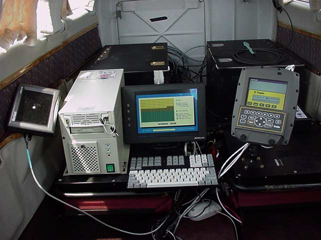
10 Equipment Configuration

11 Kodak Digital Camera: Fremont Lakes, Nebraska
12 Kodak Digital Camera: CALMIT Field Facility at ARDC
13 ASD-FR with Boresighted Video and GPS

14 AISA Hyperspectral Imager
15 Selected AISA Specifications Pushbroom imaging spectrometer built by Specim Ltd., Oulu,, Finland Spectral range: nm FOV: 21 degrees (across track)
16 Selected AISA Specifications Programmable from channels Spectral bandwidths: 1.63 to 9.80 nm Pixels per swath: 360
17 VNIR AISA Bands (Hyperspectral) Reflectance, per cent Bands Wavelength, nm
18 Why AISA? Narrow spectral features (spectroscopy) Good radiometric accuracy and large dynamic range Spatial coverage (image)
19 AISA Features Easy configuration based on ASCII files Integrated DGPS/INS for image navigation Portable and designed to fit standard mounts

20 Upward-Looking Fiber Optic To capture downwelling irradiance
21 AISA Hyperspectral Scanner 3 Operating modes: Full spectral (A mode) Full spatial (B mode) Full spectral / Partial spatial (C mode)
22 A mode Full spectral All spectral information on the CCD is stored. The minimum integration time is 150 ms Usually used in laboratory experiments and on slowly moving platforms.
23 B Mode At full spatial configuration the number of spectral channels must be reduced User can choose: integration time number of spectral channels wavelengths of the spectral channels This is the usual configuration
24 C Mode Full spectral / partial spatial All 286 channels at coarse spatial resolution The minimum integration time is 55 ms.
25 Spatial Considerations Resolution Field of View (FOV) Instantaneous Field of View (IFOV) Ground Sampling Distance (GSD)
26 Spectral Considerations Resolution Range Bandwidth or Sampling Interval
27 Spatial Resolution # Spectral Bands 1/1.5 meter 25 2/2.5 meter 35 3 meter 45 4 meter 70 Proposed configuration on a Saratoga with fixed flight speed of 120 knots.

28 AISA Optical Design
29 AISA Calibration Calibrated at the NASA John C. Stennis Space Center, Mississippi (Winter, 2001) Checked at 3DI offices in Easton, MD (Summer, 2002)
30 Calibration Targets CALMIT Field Facility at ARDC
31 Lab Calibration: Spectral Integrating sphere and monochromatic laser Cutoff filters Full Width at Half Maximum (FWHM)

32 Lab Calibration: Radiometric
33 Regarding Calibration: Abundance of uncalibrated hyperspectral data Uncalibrated data are basically worthless and misleading!calibration!!calibration!!calibration!

34 Dark Current / Signal Dark current at 3 wavelengths, across the field-of-view
35 Geolocation Accuracy Mapping Accuracy is application dependent Ground-control points / system geo-location
36 Geometric Corrections and Georeferencing Inertial Navigation System (INS) and Differential GPS (DGPS) Frame-by-frame georeferencing Pitch, roll, and yaw are encoded

37 Unrectified versus Rectified
38 Data Pre-processing AISA pre-processing software (CaliGeo)) provides: Automatic geometric correction Rectification Mosaicing Calculation of radiance or apparent at- platform reflectance (FODIS ratio) Automated batch processing provides for rapid turnaround times for data delivery.
39 Mission Planning Data are extremely sensitive to solar angle BRDF 2 hours +/- local solar zenith Time of year for extreme latitudes
40 Mission Planning Issues Cloud cover Shadows Flight turbulence

41 Agriculture: Mead, NE June 21, 2002 Color Infrared Red: 819 nm Green: 699 nm Blue: 598 nm

42 Agriculture: Ames, Iowa True Color-Bare Soil Red: 673 nm Green: 550 nm Blue: 490 nm August 9, 2002

43 Agriculture: Ames, Iowa August 9, 2002 Color Infrared-Vegetation Red: 771 nm Green: 673 nm Blue: 550 nm
 (NIR+Red) NDVI = (777-673)")
44 Sample Product: NDVI NDVI = (NIR-Red) (NIR+Red) NDVI = ( ) ( )

45 Sample Product: NDVI Image - NDVI Gray Scale Colorized Vegetation Map = +
/(NIR+Red) VARI [(Green")
46 Vegetation Indices NDVI (NIR-Red)/(NIR+Red) VARI [(Green Red)/(Green + Red Blue)]
47 Long Lake, Nebraska Sandhills June 2002 Color Infrared Red: 752 nm Green: 648 nm Blue: 550 nm
48 Long Lake, Nebraska Sandhills June 2002 RGB Composite Red: 648 nm Green: 848 nm Blue: 522 nm

49 Long Lake, Nebraska Sandhills June 2002 RGB Composite Red: 522 nm Green: 711 nm Blue: 807 nm

50 Water Quality: Fremont, NE

51 Water Quality: Greenville, MS

52 Water Quality: Apalachicola Bay, Florida October 17, 2002 RGB Composite Red: 672 nm Green: 584 nm Blue: 525 nm
53 AISA Missions: 2002 Agricultural Iowa Illinois Missouri Kansas - Konza prairie Mississippi Nebraska
54 AISA Missions: 2002 Water Quality Nebraska-Sandhills Lakes Nebraska-Fremont Lakes Florida- Apalachicola Bay
 operating at 532 and 1064 nm")
55 Future Sensors: Electrical Engineering Airborne Laser Polarimeter System (ALPS) operating at 532 and 1064 nm wavelengths

56 Future Sensors: Electrical Engineering UNL-developed noise radar scatterometer operating at GHz (L-band) and 10 GHz (X-band) frequencies
Passive Remote Sensing of Clouds from Airborne Platforms
 Passive Remote Sensing of Clouds from Airborne Platforms Why airborne measurements? My instrument: the Solar Spectral Flux Radiometer (SSFR) Some spectrometry/radiometry basics How can we infer cloud properties
16 th IOCCG Committee annual meeting. Plymouth, UK 15 17 February 2011. mission: Present status and near future
 16 th IOCCG Committee annual meeting Plymouth, UK 15 17 February 2011 The Meteor 3M Mt satellite mission: Present status and near future plans MISSION AIMS Satellites of the series METEOR M M are purposed
INTA AIRBORNE REMOTE SENSING FACILITY from the Hasselblad s cameras to the SensyTech-AHS sensor
 INTA AIRBORNE REMOTE SENSING FACILITY from the Hasselblad s cameras to the SensyTech-AHS sensor José-Antonio Gómez-Sánchez gomezsj@inta.es Remote Sensing Laboratory INSTITUTO NACIONAL DE TÉCNICA AEROESPACIAL
2.3 Spatial Resolution, Pixel Size, and Scale
 Section 2.3 Spatial Resolution, Pixel Size, and Scale Page 39 2.3 Spatial Resolution, Pixel Size, and Scale For some remote sensing instruments, the distance between the target being imaged and the platform,
Digital Remote Sensing Data Processing Digital Remote Sensing Data Processing and Analysis: An Introduction and Analysis: An Introduction
 Digital Remote Sensing Data Processing Digital Remote Sensing Data Processing and Analysis: An Introduction and Analysis: An Introduction Content Remote sensing data Spatial, spectral, radiometric and
Review for Introduction to Remote Sensing: Science Concepts and Technology
 Review for Introduction to Remote Sensing: Science Concepts and Technology Ann Johnson Associate Director ann@baremt.com Funded by National Science Foundation Advanced Technological Education program [DUE
How To Make An Orthophoto
 ISSUE 2 SEPTEMBER 2014 TSA Endorsed by: CLIENT GUIDE TO DIGITAL ORTHO- PHOTOGRAPHY The Survey Association s Client Guides are primarily aimed at other professionals such as engineers, architects, planners
Spectral Response for DigitalGlobe Earth Imaging Instruments
 Spectral Response for DigitalGlobe Earth Imaging Instruments IKONOS The IKONOS satellite carries a high resolution panchromatic band covering most of the silicon response and four lower resolution spectral
Hyperspectral Satellite Imaging Planning a Mission
 Hyperspectral Satellite Imaging Planning a Mission Victor Gardner University of Maryland 2007 AIAA Region 1 Mid-Atlantic Student Conference National Institute of Aerospace, Langley, VA Outline Objective
Soil degradation monitoring by active and passive remote-sensing means: examples with two degradation processes
 Soil degradation monitoring by active and passive remote-sensing means: examples with two degradation processes Naftaly Goldshleger, *Eyal Ben-Dor,* *Ido Livne,* U. Basson***, and R.Ben-Binyamin*Vladimir
SAMPLE MIDTERM QUESTIONS
 Geography 309 Sample MidTerm Questions Page 1 SAMPLE MIDTERM QUESTIONS Textbook Questions Chapter 1 Questions 4, 5, 6, Chapter 2 Questions 4, 7, 10 Chapter 4 Questions 8, 9 Chapter 10 Questions 1, 4, 7
From Pixel to Info-Cloud News at Leica Geosystems JACIE Denver, 31 March 2011 Ruedi Wagner Hexagon Geosystems, Geospatial Solutions Division.
 From Pixel to Info-Cloud News at Leica Geosystems JACIE Denver, 31 March 2011 Ruedi Wagner Hexagon Geosystems, Geospatial Solutions Division What else can I do with my sensor/data? Earth to Image Image
Data Processing Developments at DFD/DLR. Stefanie Holzwarth Martin Bachmann, Rudolf Richter, Martin Habermeyer, Derek Rogge
 Data Processing Developments at DFD/DLR Stefanie Holzwarth Martin Bachmann, Rudolf Richter, Martin Habermeyer, Derek Rogge EUFAR Joint Expert Working Group Meeting Edinburgh, April 14th 2011 Conclusions
Table of Contents. An Introduction to Hyperspectral Imaging Technology
 Table of Contents 1.0 Introduction... 1 2.0 Electromagnetic Radiation... 1 2.1 The Electromagnetic Spectrum... 2 2.2 Electromagnetic Interactions with Matter... 3 3.0 Spectroscopy... 5 3.1 Refraction and
LiDAR for vegetation applications
 LiDAR for vegetation applications UoL MSc Remote Sensing Dr Lewis plewis@geog.ucl.ac.uk Introduction Introduction to LiDAR RS for vegetation Review instruments and observational concepts Discuss applications
How To Fuse A Point Cloud With A Laser And Image Data From A Pointcloud
 REAL TIME 3D FUSION OF IMAGERY AND MOBILE LIDAR Paul Mrstik, Vice President Technology Kresimir Kusevic, R&D Engineer Terrapoint Inc. 140-1 Antares Dr. Ottawa, Ontario K2E 8C4 Canada paul.mrstik@terrapoint.com
Resolutions of Remote Sensing
 Resolutions of Remote Sensing 1. Spatial (what area and how detailed) 2. Spectral (what colors bands) 3. Temporal (time of day/season/year) 4. Radiometric (color depth) Spatial Resolution describes how
TerraColor White Paper
 TerraColor White Paper TerraColor is a simulated true color digital earth imagery product developed by Earthstar Geographics LLC. This product was built from imagery captured by the US Landsat 7 (ETM+)
Using Remote Sensing to Monitor Soil Carbon Sequestration
 Using Remote Sensing to Monitor Soil Carbon Sequestration E. Raymond Hunt, Jr. USDA-ARS Hydrology and Remote Sensing Beltsville Agricultural Research Center Beltsville, Maryland Introduction and Overview
Computer Vision: Machine Vision Filters. Computer Vision. Optical Filters. 25 August 2014
 Computer Vision Optical Filters 25 August 2014 Copyright 2001 2014 by NHL Hogeschool, Van de Loosdrecht Machine Vision BV and Klaas Dijkstra All rights reserved j.van.de.loosdrecht@nhl.nl, jaap@vdlmv.nl,
Realization of a UV fisheye hyperspectral camera
 Realization of a UV fisheye hyperspectral camera Valentina Caricato, Andrea Egidi, Marco Pisani and Massimo Zucco, INRIM Outline Purpose of the instrument Required specs Hyperspectral technique Optical
Land Use/Land Cover Map of the Central Facility of ARM in the Southern Great Plains Site Using DOE s Multi-Spectral Thermal Imager Satellite Images
 Land Use/Land Cover Map of the Central Facility of ARM in the Southern Great Plains Site Using DOE s Multi-Spectral Thermal Imager Satellite Images S. E. Báez Cazull Pre-Service Teacher Program University
Information Contents of High Resolution Satellite Images
 Information Contents of High Resolution Satellite Images H. Topan, G. Büyüksalih Zonguldak Karelmas University K. Jacobsen University of Hannover, Germany Keywords: satellite images, mapping, resolution,
Digital image processing
 746A27 Remote Sensing and GIS Lecture 4 Digital image processing Chandan Roy Guest Lecturer Department of Computer and Information Science Linköping University Digital Image Processing Most of the common
Multiangle cloud remote sensing from
 Multiangle cloud remote sensing from POLDER3/PARASOL Cloud phase, optical thickness and albedo F. Parol, J. Riedi, S. Zeng, C. Vanbauce, N. Ferlay, F. Thieuleux, L.C. Labonnote and C. Cornet Laboratoire
RADIOMETRIC GROUND TRUTHING FOR AIRBORNE AND SATELLITE SENSOR TESTS
 RADIOMETRIC GROUND TRUTHING FOR AIRBORNE AND SATELLITE SENSOR TESTS J. R. Smith The Boeing Company, P.O. Box 3999, M/C 8F-26, Seattle, WA 98124-2499 john.r.smith@boeing.com KEY WORDS: Radiometry, Hyper
Lake Monitoring in Wisconsin using Satellite Remote Sensing
 Lake Monitoring in Wisconsin using Satellite Remote Sensing D. Gurlin and S. Greb Wisconsin Department of Natural Resources 2015 Wisconsin Lakes Partnership Convention April 23 25, 2105 Holiday Inn Convention
INSPIRE implementation pilot project
 INSPIRE implementation pilot project Implementation of INSPIRE directive in Hungarian e-environment sector KEOP-7.6.3.0-2008-0020 Tamás Tomor PhD, project manager Trans-Tisza Environmental Inspectorate
Sky Monitoring Techniques using Thermal Infrared Sensors. sabino piazzolla Optical Communications Group JPL
 Sky Monitoring Techniques using Thermal Infrared Sensors sabino piazzolla Optical Communications Group JPL Atmospheric Monitoring The atmospheric channel has a great impact on the channel capacity at optical
Using Remote Sensing Imagery to Evaluate Post-Wildfire Damage in Southern California
 Graham Emde GEOG 3230 Advanced Remote Sensing February 22, 2013 Lab #1 Using Remote Sensing Imagery to Evaluate Post-Wildfire Damage in Southern California Introduction Wildfires are a common disturbance
APPLICATION OF TERRA/ASTER DATA ON AGRICULTURE LAND MAPPING. Genya SAITO*, Naoki ISHITSUKA*, Yoneharu MATANO**, and Masatane KATO***
 APPLICATION OF TERRA/ASTER DATA ON AGRICULTURE LAND MAPPING Genya SAITO*, Naoki ISHITSUKA*, Yoneharu MATANO**, and Masatane KATO*** *National Institute for Agro-Environmental Sciences 3-1-3 Kannondai Tsukuba
MULTIPURPOSE USE OF ORTHOPHOTO MAPS FORMING BASIS TO DIGITAL CADASTRE DATA AND THE VISION OF THE GENERAL DIRECTORATE OF LAND REGISTRY AND CADASTRE
 MULTIPURPOSE USE OF ORTHOPHOTO MAPS FORMING BASIS TO DIGITAL CADASTRE DATA AND THE VISION OF THE GENERAL DIRECTORATE OF LAND REGISTRY AND CADASTRE E.ÖZER, H.TUNA, F.Ç.ACAR, B.ERKEK, S.BAKICI General Directorate
Fig.1. The DAWN spacecraft
 Introduction Optical calibration of the DAWN framing cameras G. Abraham,G. Kovacs, B. Nagy Department of Mechatronics, Optics and Engineering Informatics Budapest University of Technology and Economics
CBERS Program Update Jacie 2011. Frederico dos Santos Liporace AMS Kepler liporace@amskepler.com
 CBERS Program Update Jacie 2011 Frederico dos Santos Liporace AMS Kepler liporace@amskepler.com Overview CBERS 3 and 4 characteristics Differences from previous CBERS satellites (CBERS 1/2/2B) Geometric
Grasshopper3 U3. Point Grey Research Inc. 12051 Riverside Way Richmond, BC Canada V6W 1K7 T (604) 242-9937 www.ptgrey.com
 242-9937 www.ptgrey.com") Grasshopper3 U3 USB 3.0 Camera Imaging Performance Specification Version 12.0 Point Grey Research Inc. 12051 Riverside Way Richmond, BC Canada V6W 1K7 T (604) 242-9937 www.ptgrey.com Copyright 2012-2015
Grasshopper3 U3 USB 3.0 Camera Imaging Performance Specification Version 12.0 Point Grey Research Inc. 12051 Riverside Way Richmond, BC Canada V6W 1K7 T (604) 242-9937 www.ptgrey.com Copyright 2012-2015
See Lab 8, Natural Resource Canada RS Tutorial web pages Tues 3/24 Supervised land cover classification See Lab 9, NR Canada RS Tutorial web pages
 SFR 406 Remote Sensing, Image Interpretation and Forest Mapping EXAM # 2 (23 April 2015) REVIEW SHEET www.umaine.edu/mial/courses/sfr406/index.htm (Lecture powerpoint & notes) TOPICS COVERED ON 2 nd EXAM:
Synthetic Sensing: Proximity / Distance Sensors
 Synthetic Sensing: Proximity / Distance Sensors MediaRobotics Lab, February 2010 Proximity detection is dependent on the object of interest. One size does not fit all For non-contact distance measurement,
LANDSAT 8 Level 1 Product Performance
 Réf: IDEAS-TN-10-QualityReport LANDSAT 8 Level 1 Product Performance Quality Report Month/Year: January 2016 Date: 26/01/2016 Issue/Rev:1/9 1. Scope of this document On May 30, 2013, data from the Landsat
Preface. Ko Ko Lwin Division of Spatial Information Science University of Tsukuba 2008
 1 Preface Remote Sensing data is one of the primary data sources in GIS analysis. The objective of this material is to provide fundamentals of Remote Sensing technology and its applications in Geographical
MODIS IMAGES RESTORATION FOR VNIR BANDS ON FIRE SMOKE AFFECTED AREA
 MODIS IMAGES RESTORATION FOR VNIR BANDS ON FIRE SMOKE AFFECTED AREA Li-Yu Chang and Chi-Farn Chen Center for Space and Remote Sensing Research, National Central University, No. 300, Zhongda Rd., Zhongli
The RapidEye optical satellite family for high resolution imagery
 'Photogrammetric Week 01' D. Fritsch & R. Spiller, Eds. Wichmann Verlag, Heidelberg 2001. Scherer, Krischke 139 The RapidEye optical satellite family for high resolution imagery STEFAN SCHERER and MANFRED
Data Processing Flow Chart
 Legend Start V1 V2 V3 Completed Version 2 Completion date Data Processing Flow Chart Data: Download a) AVHRR: 1981-1999 b) MODIS:2000-2010 c) SPOT : 1998-2002 No Progressing Started Did not start 03/12/12
Remote sensing is the collection of data without directly measuring the object it relies on the
 Chapter 8 Remote Sensing Chapter Overview Remote sensing is the collection of data without directly measuring the object it relies on the reflectance of natural or emitted electromagnetic radiation (EMR).
NASA s Dawn Mission Journey to the Asteroid Frontier
 NASA s Dawn Mission Journey to the Asteroid Frontier Dawn Lucy McFadden, Co-Investigator University of Maryland College Park, MD January 12, 2009 SBAG update 9 th Discovery Mission Dawn Explores the Earliest
High Resolution Planetary Imaging of Mars, Jupiter, Saturn, Uranus. Current state-of-the-art in Amateur capabilities, hardware and software
 High Resolution Planetary Imaging of Mars, Jupiter, Saturn, Uranus Current state-of-the-art in Amateur capabilities, hardware and software Madison, August 2014 Current state-of-the art in Planetary Imaging
Supervised Classification workflow in ENVI 4.8 using WorldView-2 imagery
 Supervised Classification workflow in ENVI 4.8 using WorldView-2 imagery WorldView-2 is the first commercial high-resolution satellite to provide eight spectral sensors in the visible to near-infrared
Methane to Markets Oil and Natural Gas Technology Transfer Workshop
 Methane to Markets Oil and Natural Gas Technology Transfer Workshop Airborne Differential Absorption Lidar (DIAL) Detection and Measurement of Fugitive Emissions Steven Stearns ANGEL Service ITT Space
Using Optech LMS to Calibrate Survey Data Without Ground Control Points
 Challenge An Optech client conducted an airborne lidar survey over a sparsely developed river valley. The data processors were finding that the data acquired in this survey was particularly difficult to
A remote sensing instrument collects information about an object or phenomenon within the
 Satellite Remote Sensing GE 4150- Natural Hazards Some slides taken from Ann Maclean: Introduction to Digital Image Processing Remote Sensing the art, science, and technology of obtaining reliable information
Remote Sensing of Clouds from Polarization
 Remote Sensing of Clouds from Polarization What polarization can tell us about clouds... and what not? J. Riedi Laboratoire d'optique Atmosphérique University of Science and Technology Lille / CNRS FRANCE
SPOT Satellite Earth Observation System Presentation to the JACIE Civil Commercial Imagery Evaluation Workshop March 2007
 SPOT Satellite Earth Observation System Presentation to the JACIE Civil Commercial Imagery Evaluation Workshop March 2007 Topics Presented Quick summary of system characteristics Formosat-2 Satellite Archive
China Earth Observation
 China High-resolution Earth Observation China Earth Observation System (CHEOS) and its Lastest Development The Earth Observation System and Data Center, CNSA 2014-2 Outlines 1 Introduction 2 The composition
Remote Sensing in Natural Resources Mapping
 Remote Sensing in Natural Resources Mapping NRS 516, Spring 2016 Overview of Remote Sensing in Natural Resources Mapping What is remote sensing? Why remote sensing? Examples of remote sensing in natural
ENVI Classic Tutorial: Atmospherically Correcting Hyperspectral Data using FLAASH 2
 ENVI Classic Tutorial: Atmospherically Correcting Hyperspectral Data Using FLAASH Atmospherically Correcting Hyperspectral Data using FLAASH 2 Files Used in This Tutorial 2 Opening the Uncorrected AVIRIS
Introduction to Imagery and Raster Data in ArcGIS
 Esri International User Conference San Diego, California Technical Workshops July 25, 2012 Introduction to Imagery and Raster Data in ArcGIS Simon Woo slides Cody Benkelman - demos Overview of Presentation
TUTORIAL Extraction of Geospatial Information from High Spatial Resolution Optical Satellite Sensors
 TUTORIAL Extraction of Geospatial Information from High Spatial Resolution Optical Satellite Sensors E. Baltsavias 1,L. Zhang 2, D. Holland 3, P.K. Srivastava 4, B. Gopala Krishna 4, T.P. Srinivasan 4
Full Waveform Digitizing, Dual Channel Airborne LiDAR Scanning System for Ultra Wide Area Mapping
 Full Waveform Digitizing, Dual Channel Airborne LiDAR Scanning System for Ultra Wide Area Mapping RIEGL LMS-Q56 high laser pulse repetition rate up to 8 khz digitization electronics for full waveform data
BRDF, BRF and HDRF in the Revised Manuscript
 Atmos. Chem. Phys. Discuss., 11, C13026 C13047, 2011 www.atmos-chem-phys-discuss.net/11/c13026/2011/ Author(s) 2011. This work is distributed under the Creative Commons Attribute 3.0 License. Atmospheric
The Sentinel-4/UVN instrument on-board MTG-S
 The Sentinel-4/UVN instrument on-board MTG-S Grégory Bazalgette Courrèges-Lacoste; Berit Ahlers; Benedikt Guldimann; Alex Short; Ben Veihelmann, Hendrik Stark ESA ESTEC European Space Technology & Research
Design of a High Resolution Multispectral Scanner for Developing Vegetation Indexes
 Design of a High Resolution Multispectral Scanner for Developing Vegetation Indexes Rishitosh kumar sinha*, Roushan kumar mishra, Sam jeba kumar, Gunasekar. S Dept. of Instrumentation & Control Engg. S.R.M
We bring quality to light. MAS 40 Mini-Array Spectrometer. light measurement
 MAS 40 Mini-Array Spectrometer light measurement Features at a glance Cost-effective and robust CCD spectrometer technology Standard USB interface Compatible with all Instrument Systems measuring adapters
ENVI THE PREMIER SOFTWARE FOR EXTRACTING INFORMATION FROM GEOSPATIAL IMAGERY.
 ENVI THE PREMIER SOFTWARE FOR EXTRACTING INFORMATION FROM GEOSPATIAL IMAGERY. ENVI Imagery Becomes Knowledge ENVI software uses proven scientific methods and automated processes to help you turn geospatial
Remote Sensing Satellite Information Sheets Geophysical Institute University of Alaska Fairbanks
 Remote Sensing Satellite Information Sheets Geophysical Institute University of Alaska Fairbanks ASTER Advanced Spaceborne Thermal Emission and Reflection Radiometer AVHRR Advanced Very High Resolution
Adaptive HSI Data Processing for Near-Real-time Analysis and Spectral Recovery *
 Adaptive HSI Data Processing for Near-Real-time Analysis and Spectral Recovery * Su May Hsu, 1 Hsiao-hua Burke and Michael Griffin MIT Lincoln Laboratory, Lexington, Massachusetts 1. INTRODUCTION Hyperspectral
Geography 403 Lecture 7 Scanners, Thermal, and Microwave
 Geography 403 Lecture 7 Scanners, Thermal, and Microwave Needs: Lect_403_7.ppt A. Basics of Passive Electric Sensors 1. Sensors absorb EMR and produce some sort of response, such as voltages differences
ENVI Classic Tutorial: Atmospherically Correcting Multispectral Data Using FLAASH 2
 ENVI Classic Tutorial: Atmospherically Correcting Multispectral Data Using FLAASH Atmospherically Correcting Multispectral Data Using FLAASH 2 Files Used in this Tutorial 2 Opening the Raw Landsat Image
IP-S2 Compact+ 3D Mobile Mapping System
 IP-S2 Compact+ 3D Mobile Mapping System 3D scanning of road and roadside features Delivers high density point clouds and 360 spherical imagery High accuracy IMU options without export control Simple Map,
EVALUATION OF AIRBORNE LIDAR DIGITAL TERRAIN MAPPING FOR HIGHWAY CORRIDOR PLANNING AND DESIGN
 Waheed Uddin Director, Center for Advanced Infrastructure Technology, Carrier Hall 203 The University of Mississippi, University, MS 38677-1848, USA cvuddin@olemiss.edu KEY WORDS: Terrain, mapping, airborne,
Selecting the appropriate band combination for an RGB image using Landsat imagery
 Selecting the appropriate band combination for an RGB image using Landsat imagery Ned Horning Version: 1.0 Creation Date: 2004-01-01 Revision Date: 2004-01-01 License: This document is licensed under a
Definition of KOMPSAT-3 Product Quality
 KOMPSAT-1 KOMPSAT-2 KOMPSAT-3 KOMPSAT-5 KOMPSAT-3A Korea Aerospace Research Institute 115 Gwahangro, Yuseong-gu Daejeon, 305-333, Korea Definition of KOMPSAT-3 Product Quality March 27, 2014 DongHan Lee
INTRODUCTION TO REMOTE SENSING
 INTRODUCTION TO REMOTE SENSING Dr Robert Sanderson New Mexico State University Satellite picture of Las Cruces, NM Table of Contents Introduction...1 Electromagnetic energy...1 Reflection and absorption...2
Contributions of the geospatial fields to monitoring sustainability of urban environments John Trinder. School of Civil and Environmental Engineering
 Contributions of the geospatial fields to monitoring sustainability of urban environments John Trinder School of Civil and Environmental Engineering 2 IMPACT OF HUMAN DEVELOPMENT Humans are modifying the
Dynamic IR Scene Projector Based Upon the Digital Micromirror Device
 Dynamic IR Scene Projector Based Upon the Digital Micromirror Device D. Brett Beasley, Matt Bender, Jay Crosby, Tim Messer, and Daniel A. Saylor Optical Sciences Corporation www.opticalsciences.com P.O.
Advanced Himawari Imager (AHI) Design and Operational Flexibility Dr. Paul C. Griffith
 Design and Operational Flexibility Dr. Paul C. Griffith") harris.com Advanced Himawari Imager (AHI) Design and Operational Flexibility Dr. Paul C. Griffith Sixth Asia/Oceania Meteorological Satellite Users' Conference, Tokyo, Japan, 10 November 2015 This document
harris.com Advanced Himawari Imager (AHI) Design and Operational Flexibility Dr. Paul C. Griffith Sixth Asia/Oceania Meteorological Satellite Users' Conference, Tokyo, Japan, 10 November 2015 This document
3D Vision An enabling Technology for Advanced Driver Assistance and Autonomous Offroad Driving
 3D Vision An enabling Technology for Advanced Driver Assistance and Autonomous Offroad Driving AIT Austrian Institute of Technology Safety & Security Department Manfred Gruber Safe and Autonomous Systems
COMPARISON OF AERIAL IMAGES, SATELLITE IMAGES AND LASER SCANNING DSM IN A 3D CITY MODELS PRODUCTION FRAMEWORK
 COMPARISON OF AERIAL IMAGES, SATELLITE IMAGES AND LASER SCANNING DSM IN A 3D CITY MODELS PRODUCTION FRAMEWORK G. Maillet, D. Flamanc Institut Géographique National, Laboratoire MATIS, Saint-Mandé, France
T-REDSPEED White paper
 T-REDSPEED White paper Index Index...2 Introduction...3 Specifications...4 Innovation...6 Technology added values...7 Introduction T-REDSPEED is an international patent pending technology for traffic violation
ANALYSIS OF HYPERSPECTRAL FIELD DATA FOR DETECTION OF SUGAR BEET DISEASES
 ANALYSIS OF HYPERSPECTRAL FIELD DATA FOR DETECTION OF SUGAR BEET DISEASES Rainer LAUDIEN*, Georg BARETH**, Reiner DOLUSCHITZ*** Department of Agricultural Economics Division: Agricultural Informatics and
'Developments and benefits of hydrographic surveying using multispectral imagery in the coastal zone
 Abstract With the recent launch of enhanced high-resolution commercial satellites, available imagery has improved from four-bands to eight-band multispectral. Simultaneously developments in remote sensing
How To Use A Hyperspectral Sensor
 Projects MINEO and HyperGreen: airborne hyperspectral data acquisition in East Greenland for environmental monitoring and mineral exploration Tapani Tukiainen In remote sensing terminology the word hyperspectral
Core Imagery Product Guide. v. 2.0
 Core Imagery Product Guide v. 2.0 Disclaimer & Copyright Copyright 2014 DigitalGlobe, Inc. All rights reserved. The DigitalGlobe s Core Imagery Product Guide is purposely designed as a general guideline
RESULTS FROM A SIMPLE INFRARED CLOUD DETECTOR
 RESULTS FROM A SIMPLE INFRARED CLOUD DETECTOR A. Maghrabi 1 and R. Clay 2 1 Institute of Astronomical and Geophysical Research, King Abdulaziz City For Science and Technology, P.O. Box 6086 Riyadh 11442,
WATER BODY EXTRACTION FROM MULTI SPECTRAL IMAGE BY SPECTRAL PATTERN ANALYSIS
 WATER BODY EXTRACTION FROM MULTI SPECTRAL IMAGE BY SPECTRAL PATTERN ANALYSIS Nguyen Dinh Duong Department of Environmental Information Study and Analysis, Institute of Geography, 18 Hoang Quoc Viet Rd.,
Lectures Remote Sensing
 Lectures Remote Sensing ATMOSPHERIC CORRECTION dr.ir. Jan Clevers Centre of Geo-Information Environmental Sciences Wageningen UR Atmospheric Correction of Optical RS Data Background When needed? Model
Nederland België / Belgique
 Cronus Brochure 2 Introduction Cronus: The first spectrometer and colorimeter in one The Cronus is world s first spectrocolorimeter combining a high en VIS spectrometer with a high speed XYZ colorimeter.
Basler. Line Scan Cameras
 Basler Line Scan Cameras High-quality line scan technology meets a cost-effective GigE interface Real color support in a compact housing size Shading correction compensates for difficult lighting conditions
Work Package Radiometry
 Work Package Radiometry EuroSDR project Radiometric aspects of digital photogrammetric imagery Eija Honkavaara Department of Remote Sensing and Photogrammetry Finnish Geodetic Institute EuroDAC Core Team
Technical Data FLIR E40bx (incl. Wi-Fi)
") Technical Data FLIR E40bx (incl. Wi-Fi) Part number: 64501-0501 Copyright 2013, FLIR Systems, Inc. All rights reserved worldwide. Names and marks appearing herein are either registered trademarks or trademarks
Technical Data FLIR E40bx (incl. Wi-Fi) Part number: 64501-0501 Copyright 2013, FLIR Systems, Inc. All rights reserved worldwide. Names and marks appearing herein are either registered trademarks or trademarks
High Resolution Information from Seven Years of ASTER Data
 High Resolution Information from Seven Years of ASTER Data Anna Colvin Michigan Technological University Department of Geological and Mining Engineering and Sciences Outline Part I ASTER mission Terra
New Technologies and Airborne LiDAR Bathymetry survey Techniques in European Environmental Coastal Mapping Projects
 New Technologies and Airborne LiDAR Bathymetry survey Techniques in European Environmental Coastal Mapping Projects Nigel Townsend, Fugro LADS Corporation SSSI, Spatial Information Day 03 August 2012 Adelaide,
Satellite Remote Sensing of Volcanic Ash
 Marco Fulle www.stromboli.net Satellite Remote Sensing of Volcanic Ash Michael Pavolonis NOAA/NESDIS/STAR SCOPE Nowcasting 1 Meeting November 19 22, 2013 1 Outline Getty Images Volcanic ash satellite remote
3D Vision An enabling Technology for Advanced Driver Assistance and Autonomous Offroad Driving
 3D Vision An enabling Technology for Advanced Driver Assistance and Autonomous Offroad Driving AIT Austrian Institute of Technology Safety & Security Department Christian Zinner Safe and Autonomous Systems
Active and Passive Microwave Remote Sensing
 Active and Passive Microwave Remote Sensing Passive remote sensing system record EMR that was reflected (e.g., blue, green, red, and near IR) or emitted (e.g., thermal IR) from the surface of the Earth.
How to calculate reflectance and temperature using ASTER data
 How to calculate reflectance and temperature using ASTER data Prepared by Abduwasit Ghulam Center for Environmental Sciences at Saint Louis University September, 2009 This instructions walk you through
The Airborne Imaging Spectrometer APEX (Airborne Prism EXperiment)
") The Airborne Imaging Spectrometer APEX (Airborne Prism EXperiment) The APEX Team: Klaus Itten, Michael Schaepman, Daniel Schläpfer, Johannes W. Kaiser, Jason Brazile (RSL) Walter Debruyn, Koen Meuleman,
The Airborne Imaging Spectrometer APEX (Airborne Prism EXperiment) The APEX Team: Klaus Itten, Michael Schaepman, Daniel Schläpfer, Johannes W. Kaiser, Jason Brazile (RSL) Walter Debruyn, Koen Meuleman,
Integrating the Solar Spectrum
 Integrating the Solar Spectrum PHYS 4400, Principles and Varieties of Solar Energy Instructor: Randy J. Ellingson The University of Toledo January 24, 203 Pop Quiz Note: quiz does not count toward grade
Hydrographic Surveying using High Resolution Satellite Images
 Hydrographic Surveying using High Resolution Satellite Images Petra PHILIPSON and Frida ANDERSSON, Sweden Key words: remote sensing, high resolution, hydrographic survey, depth estimation. SUMMARY The
Fabrizio Tadina Regional Sales Manager Western Europe Airborne Products Optech Incorporated
 Fabrizio Tadina Regional Sales Manager Western Europe Airborne Products Optech Incorporated Airborne Trends Analysis Review of market pressures that are driving Optech development efforts Product Announcements
Digital Image Fundamentals. Selim Aksoy Department of Computer Engineering Bilkent University saksoy@cs.bilkent.edu.tr
 Digital Image Fundamentals Selim Aksoy Department of Computer Engineering Bilkent University saksoy@cs.bilkent.edu.tr Imaging process Light reaches surfaces in 3D. Surfaces reflect. Sensor element receives
White paper. CCD and CMOS sensor technology Technical white paper
 White paper CCD and CMOS sensor technology Technical white paper Table of contents 1. Introduction to image sensors 3 2. CCD technology 4 3. CMOS technology 5 4. HDTV and megapixel sensors 6 5. Main differences