Definition of KOMPSAT-3 Product Quality
|
|
|
- Franklin Augustine Gilmore
- 8 years ago
- Views:
Transcription


1 KOMPSAT-1 KOMPSAT-2 KOMPSAT-3 KOMPSAT-5 KOMPSAT-3A Korea Aerospace Research Institute 115 Gwahangro, Yuseong-gu Daejeon, , Korea Definition of KOMPSAT-3 Product Quality March 27, 2014 DongHan Lee a,b, MinA Kim a, DooChun Seo a, JaeHeon Jung a, KyeongMi Jun a a b USGS EROS

 for Normal operation IQ Checking & Monitoring Quality checking for KOMPSAT-3 image data (Draft) Issues and")
2 Agenda Calibration and Validation in KARI Image data Quality for User in KARI Performance of KOMPSAT-3 after Cal/Val Additional Cal/Val items for normal period KOMPSAT-3 Image data Quality (IQ) for Normal operation IQ Checking & Monitoring Quality checking for KOMPSAT-3 image data (Draft) Issues and Discussion -2-
 Issues and")
3 Calibration & Validation in KARI -3-
4 Image data Quality for User in KARI Image data Quality for Users There is a technical gap between the requirement for manufacturing the satellite and the requirement for the image data quality for Users. Need & Define the item and the quantitative value for the image data quality for Users Almost Users have eyes without the concept of the quantitative image data quality~! There are Two kind of the Quality items for Users; Representative items: MTF, SNR, GSD, Absolute radiometric Gain/Offset, Radiometric resolution, etc. Different valued items per each image data: Noises, Location, etc. With only technology of manufacturing of Satellite and Sensor, the requirements of Users cannot be complied. Periodical monitoring of the image data Quality Optimal ground processing for the Satellite and the Sensor Continually talking and feed back with Users -4-

 Along: 6~8% (TDI 64) > 19% (MS) 0.")
5 Performance of KOMPSAT-3 after Cal/Val CVP I CVP II Key Item Requirement Value Validated Value SNR 100 >> 100 (TDI 64) MTF GSD Pointing accuracy 8%(PAN) 12%(MS) 0.7m(PAN) 2.8m(MS) 1.2km Across: 8~10% (TDI 64) Along: 6~8% (TDI 64) > 19% (MS) 0.7m (PAN) Across: 90m Along: 1 sec Location accuracy 70m CE90 < 70m CE90 MTF after MTFC Registration Ortho-image accuracy 13%(PAN) 19%(MS) 0.5pixel RMS (MS) 3.5m CE90 (Horizontal) Constraint Strip imaging Level 0 Strip & Nadir imaging Strip imaging With POD & PAD Strip imaging > 20% (PAN) Level 0 0.5pixel RMS (MS) 3.5m CE90 (Horizontal) Strip imaging Strip imaging -5-
 3.")
6 Additional Cal/Val items for Normal period Item Title Content Status Monitoring FMC Temp Monitoring the Stability of the FMC (Focus Mechanism Controller) Temperature Star imaging per 2~3 month RER, FWHM, MTF on going Resampling method Resampling method for KOMPSAT-3 Optimal Resampling method for KOMPSAT-3 to keep the Spatial Quality on going Pixel burst On Only MS Develop, Test and Apply the de-noising algorithm of it Done Port Difference On Only MS Develop, Test and Apply the de-noising algorithm of it Done Center Pattern Difference Different noise between each CCD Detector After reducing Compression noise, and updating RNUC and De-noising, the Center difference has been reduced. Done RNUC (Residual NUC) Non-linearity behind DN 1500 New RNUC table has been updated in the Processing system. Done Compression noise Many Compression noise in MS with Compression ratio 5.5 Updated by PAN 5.5 and MS 3 Done -6-

7 KOMPSAT-3 Product (Image data) Quality (IQ) for Normal operation -7-
 for Normal")
8 IQ Checking and Flow Regularly Processing & IQ Checking by Operator Regularly Monitoring by Cal/Val team If any IQ issues, report to OCCB by Cal/Val team According to the OCCB procedure, carrying out it If Any OCCB Cal/Val team Users Processing (IRPE) IQ Checking (Operator) Reseller (Satrec-i) -8-
 IQ Checking (Operator) Reseller")
 OCCB Chair Impact Assessment Coordinator Originator OCCB Members < Technical Engineer > System AEISS Camera EPS Propulsion AOCS Thermal Control TC&R")
9 Monitoring and Additional Cal/Val Monthly meeting for KOMPSAT-3 Operation and Status Also checking and talking the Product (Image data) Quality. Operational Configuration Control Board (OCCB) OCCB Chair Impact Assessment Coordinator Originator OCCB Members < Technical Engineer > System AEISS Camera EPS Propulsion AOCS Thermal Control TC&R Flight S/W Cal/Val team Ground Operation & Support -9-

10 Quality Checking for K3 Product (Draft) QR (Quality Report) for KOMPSAT-3 Image Data QR No. QR-K User No. SI Product ID K3_ _04341_ _L1R S/W Version PMS. V Processing Date Processed By KARI, Gil-Dong Hong Anomalies Image Band Constraint (TBR) ( - Level 2, - Level 3) MS PAN Level 1 Level 2 Level 3 B G R N Dynamic range > < 500 Saturation < 1% 1-2% > 2% Abnormal Pixel (except Blooming) Equalization: inter-detector (NUC) diagonal, horizontal, vertical, First pixel Pattern Center Pattern noise Pixel burst (Port difference) Compression noise ~2 3~10 > 10 20DN 20~50DN > 50DN none none isolated noise isolated noise recurrent noise recurrent noise 20DN 20~50DN > 50DN none isolated blocks recurrent blocks Registration (MS-MS) < > 0.75 Registration (MS-PAN) < > 0.75 Location accuracy < 70m m > 150m Comments / Image chip Check Comments QR (Quality Report) is the Internal report in KARI to monitor the KOMPSAT-3 Product (Image data) Quality. Review Date Review Comments Reviewed By -10-
 Compression noise ~2 3~10 > 10 20DN 20~50DN > 50DN none none isolated noise isolated noise recurrent noise recurrent noise 20DN 20~50DN > 50DN none isolated blocks recurrent blocks")
 20 DN 20~50 DN > 50 DN Pattern noise diagonal, horizontal, vertical, First pixel none isolated noise recurrent noise Center Pattern none isolated noise")
11 Quality Checking for K3 Product (Draft) Anomalies Image Constraint (TBR) Level 1 Level 2 Level 3 Dynamic range > ~1000 < 500 Saturation < 1% 1~2% > 2% Abnormal Pixel (except Blooming) ~2 3~10 > 10 Equalization: inter-detector (NUC) 20 DN 20~50 DN > 50 DN Pattern noise diagonal, horizontal, vertical, First pixel none isolated noise recurrent noise Center Pattern none isolated noise recurrent noise Pixel burst (Port difference) 20 DN 20~50 DN > 50 DN Compression noise none isolated noise recurrent noise Constraint - Level 1: Accepted, Level 2: To be Proposed, Level 3: Rejected Cloud, Water, Snow area: to be take off for constraints: saturation, compression, NUC and pattern noise Isolated & Recurrent (TBR) Isolated Recurrent Number 2~4 >= 5 Area of 1 part 100x x100 DN difference 20~50 DN > 50 DN Level 1: Accepted Level 2: To be Proposed Level 3: Rejected In case of Compression noise, there is no limitation of the number of the compressed region for the Level
 Isolated Recurrent Number 2~4 >= 5 Area of 1 part 100x100 100x100 DN")

12 Anomalies Image (IQ) Dynamic Range Constraint (TBR) Level 1 Level 2 Level 3 Dynamic range (0 ~ 16363) > ~1000 < 500 Linear 2% in Scroll window in ENVI (TBR) DN(Max Min) 3500 = Except the next area Uniform bright area Forest, Farm, Desert, Ice, Mountain, Big river, Big lake, etc. Snow, Cloud, Ocean, etc. K3_ _03480_ _L1R K3_ _04341_ _L1R Only ROI requested by User Histogram of Linear 2% in Scroll window in ENVI User want a sufficient dynamic range in the satellite radiometric resolution. KOMPSAT-3: 14bit 0 ~ Not stretching in the Processing system -12-

 SNOW Only ROI requested by User User never want a saturated image data product.")
13 Anomalies Image (IQ) Saturation Constraint (TBR) Level 1 Level 2 Level 3 Saturation < 1% 1~2% > 2% Basically, >16383 DN, but The Saturated area has a width of DN after the Processing system Except the next area Snow, Ice, Cloud, Salt desert, etc. MS Green band: Saturation in SF ( ) SNOW Only ROI requested by User User never want a saturated image data product. Several exposures of Satellite be needed according to the imaging area. KOMPSAT-3 has Two TDI stages. KOMPSAT-3 data collection planning system has a Radiance (Reflectance) calculating module in Worldwide. K3_ _04341_ _L1R_B -13-
 calculating module in Worldwide.")
 Speckle noise Number of Abnormal parts in a image data product Not number of abnormal pixels Speckle noise in MS Except Blooming But, in case of Big and Large blooming, KARI Cal/Val team will")
14 Anomalies Image (IQ) Abnormal pixel (except Blooming) Constraint (TBR) Level 1 Level 2 Level 3 Abnormal pixel (No. of Part) ~2 3 ~ 10 > 10 Abnormal DN of any Pixel (ex.) Speckle noise Number of Abnormal parts in a image data product Not number of abnormal pixels Speckle noise in MS Except Blooming But, in case of Big and Large blooming, KARI Cal/Val team will inspect it. (ex) Left bottom figure. (TDI CCD) User don t want the Abnormal pixel User needs the location of the Abnormal pixel _05267_024_P7 Large Blooming by the direct solar incidence reflection -14-
 Left bottom figure.")


15 Anomalies Image (IQ) Equalization: inter-detector (NUC) Constraint (TBR) Level 1 Level 2 Level 3 Equalization (NUC) 20 DN 20~50 DN > 50 DN At less than around 1500DN, NUC is NOK. Different DN range per each Band Lake, Ocean, River, Dark Shadow, etc. RNUC module in IRPE PMS has been Ready Updated RNUC table K3_ _03379_ _L1R_P One of the main purpose of the High resolution image data product is detecting and recognizing on a Land area. but, User also want clear image in the coast and lake area. K3_ _03379_ _L1R_P -15-

16 Updated RNUC table (Additional Cal/Val item) CALL0F_ _02661 (PAN) Before After -16-

 none isolated recurrent Isolated Recurrent Number 2~4 >= 5 Area of 1 part 100x100 100x100 DN difference 20~50 DN > 50 DN Diagonal noise in MS Green Vertical, Horizontal, First pixel noise in PAN")
17 Anomalies Image Pattern noise (Diagonal, Horizontal, Vertical, First pixel) Constraint (TBR) Level 1 Level 2 Level 3 Pattern noise (Diagonal, etc.) none isolated recurrent Isolated Recurrent Number 2~4 >= 5 Area of 1 part 100x x100 DN difference 20~50 DN > 50 DN Diagonal noise in MS Green Vertical, Horizontal, First pixel noise in PAN KOMPSAT-3 Radiometric resolution is 14 bit The background noise level is 15 DN User may be difficult to determine any information by the pattern noise. A rough de-noising may reduce and remove any information. So, the optimized de-noising for KOMPSAT-3 has been applied. -17-

18 Pattern noise (Center pattern difference ) Constraint (TBR) Anomalies Image Level 1 Level 2 Level 3 Pattern noise (Center pattern) none isolated recurrent Isolated Recurrent Number 2~4 >= 5 Area of 1 part 100x x100 DN difference 20~50 DN > 50 DN The noise on Each detector is different Pattern noise Compression noise RNUC User don t want any noise The optimized de-noising for KOMPSAT-3 has been applied. -18-

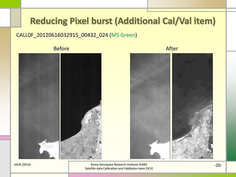
19 Pattern noise (Pixel burst, Port difference) Constraint (TBR) Anomalies Image Level 1 Level 2 Level 3 Pattern noise (Pixel burst) none isolated recurrent Isolated Recurrent Number 2~4 >= 5 Area of 1 part 100x x100 DN difference 20~50 DN > 50 DN Only MS band Width of Pixel burst is 50 pixel Width of Port Diff is 300~1500 DN difference is 20~50 DN Pixel burst in K3_ _03855_ _L1R_B User don t want any noise The optimized de-noising for KOMPSAT-3 has been applied. Port difference in K3_ _03379_ _L1R_B Profile of Port difference -19-

")

20 Reducing Pixel burst (Additional Cal/Val item) CALL0F_ _00432_024 (MS Green) Before After -20-

21 Compression noise (Additional Cal/Val item) Constraint (TBR) Anomalies Image Level 1 Level 2 Level 3 Compression noise none isolated recurrent Isolated Recurrent Number 2~4 >= 5 Area of 1 part 100x x100 DN difference 20~50 DN > 50 DN Compression ratio is 5.5 by CCSDS B-1 (Wavelet) PAN has a little MS has many Uniform area nearby high frequency area in city User don t want the compression noise KOMPSAT-3 has been changed PAN: 5.5 MS: 3 KOMPSAT-3 has little compression noise with the Compression ratio 3. K3_ _03927_ _L1R_B -21-
22 Monitoring of KOMPSAT-3 Product Quality Reducing the Noise from Jan after applying the additional Cal/Val But, Compression noise is still high. Because User(reseller) can choose the Compression ratio and still use 5.5 for MS image data. -22-
23 Issues and Discussion -23-
24 Issues and Discussion QR (Quality Report), that is the Internal report in KARI to monitor the KOMPSAT-3 Product (Image data) Quality, is Draft just now. Definite quantitative value for the image data Quality has to be determined. For, and From User Item, and Value of it The main purpose of KOMPSAT-3 is just Detecting and Recognizing. High resolution remote sensing satellite nadir = 0.7m) Any difference of the image data Quality according to Resolution? If no, what is the representative item of the image data Quality for them? In case of KOMPSAT-3 & KOMPSAT-2, After Cal/Val, all Requirements of the image data Quality were Complied. But User didn t comply the Quality of K3 & K2 Product, and then, Additional Cal/Val work for User has been done and doing~! We need more work for it~! -24-
25 Representative & Product Quality (?) This is my Question and Concern. Is there standard and general Representative and Product Quality for Users? Car Computer Imagery Remark by Purpose Bus, Sedan, SUV, Truck, etc. Server, Desktop, Laptop, Tablet, etc. SAR, IR, Visual, Resolution, etc. by Budget Bentz, BMW, Lexus Toyota, Honda, Kia? WV, GeoEye KOMPSAT Landsat Representative Product Quality (IQ) Engine size, etc. Scratch, Driving, etc. CPU, Memory, HDD (SSD), Weight, OS, etc. Dead pixel, OS, S/W, KB, Mouse, etc. GSD, MTF, SNR, etc. Noise, etc. Performance (Specification) Users can look at & recognize -25-

26 Thank you for KOMPSAT~! -26-
SAMPLE MIDTERM QUESTIONS
 Geography 309 Sample MidTerm Questions Page 1 SAMPLE MIDTERM QUESTIONS Textbook Questions Chapter 1 Questions 4, 5, 6, Chapter 2 Questions 4, 7, 10 Chapter 4 Questions 8, 9 Chapter 10 Questions 1, 4, 7
Information Contents of High Resolution Satellite Images
 Information Contents of High Resolution Satellite Images H. Topan, G. Büyüksalih Zonguldak Karelmas University K. Jacobsen University of Hannover, Germany Keywords: satellite images, mapping, resolution,
LANDSAT 8 Level 1 Product Performance
 Réf: IDEAS-TN-10-QualityReport LANDSAT 8 Level 1 Product Performance Quality Report Month/Year: January 2016 Date: 26/01/2016 Issue/Rev:1/9 1. Scope of this document On May 30, 2013, data from the Landsat
From Pixel to Info-Cloud News at Leica Geosystems JACIE Denver, 31 March 2011 Ruedi Wagner Hexagon Geosystems, Geospatial Solutions Division.
 From Pixel to Info-Cloud News at Leica Geosystems JACIE Denver, 31 March 2011 Ruedi Wagner Hexagon Geosystems, Geospatial Solutions Division What else can I do with my sensor/data? Earth to Image Image
Digital image processing
 746A27 Remote Sensing and GIS Lecture 4 Digital image processing Chandan Roy Guest Lecturer Department of Computer and Information Science Linköping University Digital Image Processing Most of the common
16 th IOCCG Committee annual meeting. Plymouth, UK 15 17 February 2011. mission: Present status and near future
 16 th IOCCG Committee annual meeting Plymouth, UK 15 17 February 2011 The Meteor 3M Mt satellite mission: Present status and near future plans MISSION AIMS Satellites of the series METEOR M M are purposed
High Resolution Information from Seven Years of ASTER Data
 High Resolution Information from Seven Years of ASTER Data Anna Colvin Michigan Technological University Department of Geological and Mining Engineering and Sciences Outline Part I ASTER mission Terra
CBERS Program Update Jacie 2011. Frederico dos Santos Liporace AMS Kepler liporace@amskepler.com
 CBERS Program Update Jacie 2011 Frederico dos Santos Liporace AMS Kepler liporace@amskepler.com Overview CBERS 3 and 4 characteristics Differences from previous CBERS satellites (CBERS 1/2/2B) Geometric
SPOT Satellite Earth Observation System Presentation to the JACIE Civil Commercial Imagery Evaluation Workshop March 2007
 SPOT Satellite Earth Observation System Presentation to the JACIE Civil Commercial Imagery Evaluation Workshop March 2007 Topics Presented Quick summary of system characteristics Formosat-2 Satellite Archive
TerraColor White Paper
 TerraColor White Paper TerraColor is a simulated true color digital earth imagery product developed by Earthstar Geographics LLC. This product was built from imagery captured by the US Landsat 7 (ETM+)
Advanced Image Management using the Mosaic Dataset
 Esri International User Conference San Diego, California Technical Workshops July 25, 2012 Advanced Image Management using the Mosaic Dataset Vinay Viswambharan, Mike Muller Agenda ArcGIS Image Management
SLC-off Gap-Filled Products Gap-Fill Algorithm Methodology
 SLC-off Gap-illed roducts Gap-ill Algorithm Methodology Background The U.S. Geological Survey (USGS) Earth Resources Observation Systems (EROS) Data Center (EDC) has developed multi-scene (same path/row)
THE GOCI INSTRUMENT ON COMS MISSION THE FIRST GEOSTATIONARY OCEAN COLOR IMAGER
 THE GOCI INSTRUMENT ON COMS MISSION THE FIRST GEOSTATIONARY OCEAN COLOR IMAGER Topic 1 - Optical instruments for Earth / Planets surface and atmosphere study François FAURE, Astrium SAS Satellite, Toulouse,
Work Package Radiometry
 Work Package Radiometry EuroSDR project Radiometric aspects of digital photogrammetric imagery Eija Honkavaara Department of Remote Sensing and Photogrammetry Finnish Geodetic Institute EuroDAC Core Team
WATER BODY EXTRACTION FROM MULTI SPECTRAL IMAGE BY SPECTRAL PATTERN ANALYSIS
 WATER BODY EXTRACTION FROM MULTI SPECTRAL IMAGE BY SPECTRAL PATTERN ANALYSIS Nguyen Dinh Duong Department of Environmental Information Study and Analysis, Institute of Geography, 18 Hoang Quoc Viet Rd.,
ANALYSIS OF FOREST CHANGE IN FIRE DAMAGE AREA USING SATELLITE IMAGES
 ANALYSIS OF FOREST CHANGE IN FIRE DAMAGE AREA USING SATELLITE IMAGES Joon Mook Kang, Professor Joon Kyu Park, Ph.D Min Gyu Kim, Ph.D._Candidate Dept of Civil Engineering, Chungnam National University 220
MODULATION TRANSFER FUNCTION MEASUREMENT METHOD AND RESULTS FOR THE ORBVIEW-3 HIGH RESOLUTION IMAGING SATELLITE
 MODULATION TRANSFER FUNCTION MEASUREMENT METHOD AND RESULTS FOR THE ORBVIEW-3 HIGH RESOLUTION IMAGING SATELLITE K. Kohm ORBIMAGE, 1835 Lackland Hill Parkway, St. Louis, MO 63146, USA kohm.kevin@orbimage.com
Personal Identity Verification (PIV) IMAGE QUALITY SPECIFICATIONS FOR SINGLE FINGER CAPTURE DEVICES
 IMAGE QUALITY SPECIFICATIONS FOR SINGLE FINGER CAPTURE DEVICES") Personal Identity Verification (PIV) IMAGE QUALITY SPECIFICATIONS FOR SINGLE FINGER CAPTURE DEVICES 1.0 SCOPE AND PURPOSE These specifications apply to fingerprint capture devices which scan and capture
Personal Identity Verification (PIV) IMAGE QUALITY SPECIFICATIONS FOR SINGLE FINGER CAPTURE DEVICES 1.0 SCOPE AND PURPOSE These specifications apply to fingerprint capture devices which scan and capture
Digital Image Fundamentals. Selim Aksoy Department of Computer Engineering Bilkent University saksoy@cs.bilkent.edu.tr
 Digital Image Fundamentals Selim Aksoy Department of Computer Engineering Bilkent University saksoy@cs.bilkent.edu.tr Imaging process Light reaches surfaces in 3D. Surfaces reflect. Sensor element receives
Cloud Masking and Cloud Products
 Cloud Masking and Cloud Products MODIS Operational Algorithm MOD35 Paul Menzel, Steve Ackerman, Richard Frey, Kathy Strabala, Chris Moeller, Liam Gumley, Bryan Baum MODIS Cloud Masking Often done with
TUTORIAL Extraction of Geospatial Information from High Spatial Resolution Optical Satellite Sensors
 TUTORIAL Extraction of Geospatial Information from High Spatial Resolution Optical Satellite Sensors E. Baltsavias 1,L. Zhang 2, D. Holland 3, P.K. Srivastava 4, B. Gopala Krishna 4, T.P. Srinivasan 4
ENVI Classic Tutorial: Atmospherically Correcting Multispectral Data Using FLAASH 2
 ENVI Classic Tutorial: Atmospherically Correcting Multispectral Data Using FLAASH Atmospherically Correcting Multispectral Data Using FLAASH 2 Files Used in this Tutorial 2 Opening the Raw Landsat Image
Multiangle cloud remote sensing from
 Multiangle cloud remote sensing from POLDER3/PARASOL Cloud phase, optical thickness and albedo F. Parol, J. Riedi, S. Zeng, C. Vanbauce, N. Ferlay, F. Thieuleux, L.C. Labonnote and C. Cornet Laboratoire
Satellite Altimetry Missions
 Satellite Altimetry Missions SINGAPORE SPACE SYMPOSIUM 30 TH SEPTEMBER 2015 AUTHORS: LUCA SIMONINI/ ERICK LANSARD/ JOSE M GONZALEZ www.thalesgroup.com Table of Content General Principles and Applications
High Resolution Digital Surface Models and Orthoimages for Telecom Network Planning
 Renouard, Lehmann 241 High Resolution Digital Surface Models and Orthoimages for Telecom Network Planning LAURENT RENOUARD, S ophia Antipolis FRANK LEHMANN, Berlin ABSTRACT DLR of Germany and ISTAR of
Integrated Sensor Analysis Tool (I-SAT )
") FRONTIER TECHNOLOGY, INC. Advanced Technology for Superior Solutions. Integrated Sensor Analysis Tool (I-SAT ) Core Visualization Software Package Abstract As the technology behind the production of large
FRONTIER TECHNOLOGY, INC. Advanced Technology for Superior Solutions. Integrated Sensor Analysis Tool (I-SAT ) Core Visualization Software Package Abstract As the technology behind the production of large
SLSTR Breakout Summary - Gary Corlett (22/03/2012)
") SLSTR Breakout Summary - Gary Corlett (22/03/2012) [Updated 16/04/2012 with post meeting comments from Gorm Dybkjær, Simon hook and David Meldrum] The breakout session started with a clean slate and identified
SLSTR Breakout Summary - Gary Corlett (22/03/2012) [Updated 16/04/2012 with post meeting comments from Gorm Dybkjær, Simon hook and David Meldrum] The breakout session started with a clean slate and identified
Review for Introduction to Remote Sensing: Science Concepts and Technology
 Review for Introduction to Remote Sensing: Science Concepts and Technology Ann Johnson Associate Director ann@baremt.com Funded by National Science Foundation Advanced Technological Education program [DUE
A PHOTOGRAMMETRIC APPRAOCH FOR AUTOMATIC TRAFFIC ASSESSMENT USING CONVENTIONAL CCTV CAMERA
 A PHOTOGRAMMETRIC APPRAOCH FOR AUTOMATIC TRAFFIC ASSESSMENT USING CONVENTIONAL CCTV CAMERA N. Zarrinpanjeh a, F. Dadrassjavan b, H. Fattahi c * a Islamic Azad University of Qazvin - nzarrin@qiau.ac.ir
Passive Remote Sensing of Clouds from Airborne Platforms
 Passive Remote Sensing of Clouds from Airborne Platforms Why airborne measurements? My instrument: the Solar Spectral Flux Radiometer (SSFR) Some spectrometry/radiometry basics How can we infer cloud properties
Overview of the IR channels and their applications
 Ján Kaňák Slovak Hydrometeorological Institute Jan.kanak@shmu.sk Overview of the IR channels and their applications EUMeTrain, 14 June 2011 Ján Kaňák, SHMÚ 1 Basics in satellite Infrared image interpretation
Remote Sensing of Clouds from Polarization
 Remote Sensing of Clouds from Polarization What polarization can tell us about clouds... and what not? J. Riedi Laboratoire d'optique Atmosphérique University of Science and Technology Lille / CNRS FRANCE
RESOLUTION MERGE OF 1:35.000 SCALE AERIAL PHOTOGRAPHS WITH LANDSAT 7 ETM IMAGERY
 RESOLUTION MERGE OF 1:35.000 SCALE AERIAL PHOTOGRAPHS WITH LANDSAT 7 ETM IMAGERY M. Erdogan, H.H. Maras, A. Yilmaz, Ö.T. Özerbil General Command of Mapping 06100 Dikimevi, Ankara, TURKEY - (mustafa.erdogan;
Change Detection In Satellite Observed Nightime Lights: 1992-2003
 Change Detection In Satellite Observed Nightime Lights: 1992-2003 Chris Elvidge, Earth Observation Group NOAA National Geophysical Data Center (NGDC). Boulder, Colorado chris.elvidge@noaa.gov Kim Baugh,
Hyperspectral Satellite Imaging Planning a Mission
 Hyperspectral Satellite Imaging Planning a Mission Victor Gardner University of Maryland 2007 AIAA Region 1 Mid-Atlantic Student Conference National Institute of Aerospace, Langley, VA Outline Objective
McIDAS-V Tutorial Displaying Polar Satellite Imagery updated September 2015 (software version 1.5)
") McIDAS-V Tutorial Displaying Polar Satellite Imagery updated September 2015 (software version 1.5) McIDAS-V is a free, open source, visualization and data analysis software package that is the next generation
McIDAS-V Tutorial Displaying Polar Satellite Imagery updated September 2015 (software version 1.5) McIDAS-V is a free, open source, visualization and data analysis software package that is the next generation
Supervised Classification workflow in ENVI 4.8 using WorldView-2 imagery
 Supervised Classification workflow in ENVI 4.8 using WorldView-2 imagery WorldView-2 is the first commercial high-resolution satellite to provide eight spectral sensors in the visible to near-infrared
Canada J1K 2R1 b. * Corresponding author: Email: wangz@dmi.usherb.ca; Tel. +1-819-8218000-2855;Fax:+1-819-8218200
 Production of -resolution remote sensing images for navigation information infrastructures Wang Zhijun a, *, Djemel Ziou a, Costas Armenakis b a Dept of mathematics and informatics, University of Sherbrooke,
Introduction to CCDs and CCD Data Calibration
 Introduction to CCDs and CCD Data Calibration Dr. William Welsh San Diego State University CCD: charge coupled devices integrated circuit silicon chips that can record optical (and X-ray) light pixel =
Generation of Cloud-free Imagery Using Landsat-8
 Generation of Cloud-free Imagery Using Landsat-8 Byeonghee Kim 1, Youkyung Han 2, Yonghyun Kim 3, Yongil Kim 4 Department of Civil and Environmental Engineering, Seoul National University (SNU), Seoul,
High Resolution Planetary Imaging
 High Resolution Planetary Imaging Fighting the Atmosphere Getting out of the Atmosphere Adaptive Optics Lucky Imaging Lucky Imaging is the process of capturing planets using a CCD video camera. A software
Selecting the appropriate band combination for an RGB image using Landsat imagery
 Selecting the appropriate band combination for an RGB image using Landsat imagery Ned Horning Version: 1.0 Creation Date: 2004-01-01 Revision Date: 2004-01-01 License: This document is licensed under a
An Introduction to the MTG-IRS Mission
 An Introduction to the MTG-IRS Mission Stefano Gigli, EUMETSAT IRS-NWC Workshop, Eumetsat HQ, 25-0713 Summary 1. Products and Performance 2. Design Overview 3. L1 Data Organisation 2 Part 1 1. Products
Spectral Response for DigitalGlobe Earth Imaging Instruments
 Spectral Response for DigitalGlobe Earth Imaging Instruments IKONOS The IKONOS satellite carries a high resolution panchromatic band covering most of the silicon response and four lower resolution spectral
DYNAMIC RANGE IMPROVEMENT THROUGH MULTIPLE EXPOSURES. Mark A. Robertson, Sean Borman, and Robert L. Stevenson
 c 1999 IEEE. Personal use of this material is permitted. However, permission to reprint/republish this material for advertising or promotional purposes or for creating new collective works for resale or
PIXEL-LEVEL IMAGE FUSION USING BROVEY TRANSFORME AND WAVELET TRANSFORM
 PIXEL-LEVEL IMAGE FUSION USING BROVEY TRANSFORME AND WAVELET TRANSFORM Rohan Ashok Mandhare 1, Pragati Upadhyay 2,Sudha Gupta 3 ME Student, K.J.SOMIYA College of Engineering, Vidyavihar, Mumbai, Maharashtra,
The Role of SPOT Satellite Images in Mapping Air Pollution Caused by Cement Factories
 The Role of SPOT Satellite Images in Mapping Air Pollution Caused by Cement Factories Dr. Farrag Ali FARRAG Assistant Prof. at Civil Engineering Dept. Faculty of Engineering Assiut University Assiut, Egypt.
The USGS Landsat Big Data Challenge
 The USGS Landsat Big Data Challenge Brian Sauer Engineering and Development USGS EROS bsauer@usgs.gov U.S. Department of the Interior U.S. Geological Survey USGS EROS and Landsat 2 Data Utility and Exploitation
A tiered reconnaissance approach toward flood monitoring utilising multi-source radar and optical data
 5 th International Workshop on Remote Sensing for Disaster Response A tiered reconnaissance approach toward flood monitoring utilising multi-source radar and optical data Anneley McMillan Dr. Beverley
How to calculate reflectance and temperature using ASTER data
 How to calculate reflectance and temperature using ASTER data Prepared by Abduwasit Ghulam Center for Environmental Sciences at Saint Louis University September, 2009 This instructions walk you through
The premier software for extracting information from geospatial imagery.
 Imagery Becomes Knowledge ENVI The premier software for extracting information from geospatial imagery. ENVI Imagery Becomes Knowledge Geospatial imagery is used more and more across industries because
A KNOWLEDGE-BASED APPROACH FOR REDUCING CLOUD AND SHADOW ABSTRACT
 A KNOWLEDGE-BASED APPROACH FOR REDUCING CLOUD AND SHADOW Mingjun Song, Graduate Research Assistant Daniel L. Civco, Director Laboratory for Earth Resources Information Systems Department of Natural Resources
Séries U3-CMOS. Nouvelles. Caméras Numériques USB3. Ultra rapides
 Séries U3-CMOS Nouvelles Caméras Numériques USB3 Ultra rapides 1 Cette nouvelle série de caméras pour la microscopie et adaptée à un grand nombre d applications. 2 Fabrications et contrôles en salles blanches
Cloud detection and clearing for the MOPITT instrument
 Cloud detection and clearing for the MOPITT instrument Juying Warner, John Gille, David P. Edwards and Paul Bailey National Center for Atmospheric Research, Boulder, Colorado ABSTRACT The Measurement Of
Received in revised form 24 March 2004; accepted 30 March 2004
 Remote Sensing of Environment 91 (2004) 237 242 www.elsevier.com/locate/rse Cloud detection in Landsat imagery of ice sheets using shadow matching technique and automatic normalized difference snow index
Solomon Systech Image Processor for Car Entertainment Application
 Company: Author: Piony Yeung Title: Technical Marketing Engineer Introduction Mobile video has taken off recently as a fun, viable, and even necessary addition to in-car entertainment. Several new SUV
Artemis Capture. User s Manual
 Artemis Capture User s Manual Version 3.0 - July 2015 Contents 1. Introduction... 4 1.1 Key Features... 4 2. Installing the Software... 5 2.1 Opening Artemis Capture... 5 3. The Main Screen... 6 3.1 Tool
Using Microsoft Picture Manager
 Using Microsoft Picture Manager Storing Your Photos It is suggested that a county store all photos for use in the County CMS program in the same folder for easy access. For the County CMS Web Project it
The RapidEye optical satellite family for high resolution imagery
 'Photogrammetric Week 01' D. Fritsch & R. Spiller, Eds. Wichmann Verlag, Heidelberg 2001. Scherer, Krischke 139 The RapidEye optical satellite family for high resolution imagery STEFAN SCHERER and MANFRED
Face detection is a process of localizing and extracting the face region from the
 Chapter 4 FACE NORMALIZATION 4.1 INTRODUCTION Face detection is a process of localizing and extracting the face region from the background. The detected face varies in rotation, brightness, size, etc.
Wireless PTZ Cloud Camera TV-IP851WC (v1.0r)
") (v1.0r) TRENDnet s Wireless PTZ Cloud Camera, model, takes the work out of viewing video over the internet. Previously to view video remotely, users needed to perform many complicated and time consuming
(v1.0r) TRENDnet s Wireless PTZ Cloud Camera, model, takes the work out of viewing video over the internet. Previously to view video remotely, users needed to perform many complicated and time consuming
Obtaining and Processing MODIS Data
 Obtaining and Processing MODIS Data MODIS is an extensive program using sensors on two satellites that each provide complete daily coverage of the earth. The data have a variety of resolutions; spectral,
Vorstellung eines photogrammetrischen Kamerasystems für UAVs mit hochgenauer GNSS/INS Information für standardisierte Verarbeitungsverfahren
 Vorstellung eines photogrammetrischen Kamerasystems für UAVs mit hochgenauer GNSS/INS Information für standardisierte Verarbeitungsverfahren T. Kraft a, M. Geßner a, H. Meißner a, H. J. Przybilla b, M.
Choosing a digital camera for your microscope John C. Russ, Materials Science and Engineering Dept., North Carolina State Univ.
 Choosing a digital camera for your microscope John C. Russ, Materials Science and Engineering Dept., North Carolina State Univ., Raleigh, NC One vital step is to choose a transfer lens matched to your
telemetry Rene A.J. Chave, David D. Lemon, Jan Buermans ASL Environmental Sciences Inc. Victoria BC Canada rchave@aslenv.com I.
 Near real-time transmission of reduced data from a moored multi-frequency sonar by low bandwidth telemetry Rene A.J. Chave, David D. Lemon, Jan Buermans ASL Environmental Sciences Inc. Victoria BC Canada
VIIRS-CrIS mapping. NWP SAF AAPP VIIRS-CrIS Mapping
 NWP SAF AAPP VIIRS-CrIS Mapping This documentation was developed within the context of the EUMETSAT Satellite Application Facility on Numerical Weather Prediction (NWP SAF), under the Cooperation Agreement
Introduction to Imagery and Raster Data in ArcGIS
 Esri International User Conference San Diego, California Technical Workshops July 25, 2012 Introduction to Imagery and Raster Data in ArcGIS Simon Woo slides Cody Benkelman - demos Overview of Presentation
MOD09 (Surface Reflectance) User s Guide
 User s Guide") MOD09 (Surface ) User s Guide MODIS Land Surface Science Computing Facility Principal Investigator: Dr. Eric F. Vermote Web site: http://modis-sr.ltdri.org Correspondence e-mail address: mod09@ltdri.org
MOD09 (Surface ) User s Guide MODIS Land Surface Science Computing Facility Principal Investigator: Dr. Eric F. Vermote Web site: http://modis-sr.ltdri.org Correspondence e-mail address: mod09@ltdri.org
High Resolution Planetary Imaging Workflow
 High Resolution Planetary Imaging Workflow Fighting the Atmosphere Getting out of the Atmosphere Adaptive Optics Lucky Imaging Lucky Imaging is the process of capturing planets using a CCD video camera.
Chapter 7 Stability and Cloud Development. Atmospheric Stability
 Chapter 7 Stability and Cloud Development Atmospheric Stability 1 Cloud Development - stable environment Stable air (parcel) - vertical motion is inhibited if clouds form, they will be shallow, layered
product overview pco.edge family the most versatile scmos camera portfolio on the market pioneer in scmos image sensor technology
 product overview family the most versatile scmos camera portfolio on the market pioneer in scmos image sensor technology scmos knowledge base scmos General Information PCO scmos cameras are a breakthrough
Grasshopper3 U3. Point Grey Research Inc. 12051 Riverside Way Richmond, BC Canada V6W 1K7 T (604) 242-9937 www.ptgrey.com
 242-9937 www.ptgrey.com") Grasshopper3 U3 USB 3.0 Camera Imaging Performance Specification Version 12.0 Point Grey Research Inc. 12051 Riverside Way Richmond, BC Canada V6W 1K7 T (604) 242-9937 www.ptgrey.com Copyright 2012-2015
Grasshopper3 U3 USB 3.0 Camera Imaging Performance Specification Version 12.0 Point Grey Research Inc. 12051 Riverside Way Richmond, BC Canada V6W 1K7 T (604) 242-9937 www.ptgrey.com Copyright 2012-2015
High Resolution Spatial Electroluminescence Imaging of Photovoltaic Modules
 High Resolution Spatial Electroluminescence Imaging of Photovoltaic Modules Abstract J.L. Crozier, E.E. van Dyk, F.J. Vorster Nelson Mandela Metropolitan University Electroluminescence (EL) is a useful
A remote sensing instrument collects information about an object or phenomenon within the
 Satellite Remote Sensing GE 4150- Natural Hazards Some slides taken from Ann Maclean: Introduction to Digital Image Processing Remote Sensing the art, science, and technology of obtaining reliable information
International Archives of the Photogrammetry, Remote Sensing and Spatial Information Sciences, Vol. XXXIV-5/W10
 Accurate 3D information extraction from large-scale data compressed image and the study of the optimum stereo imaging method Riichi NAGURA *, * Kanagawa Institute of Technology nagura@ele.kanagawa-it.ac.jp
Introducing AVP 3000 Voyager. JPEG 2000 in DSNG
 Introducing AVP 3000 Voyager JPEG 2000 in DSNG Executive Summary Compelling live News, Events and Sports is key to audience share. In a fragmented multi channel, multi platform market, live content continues
Methods for Monitoring Forest and Land Cover Changes and Unchanged Areas from Long Time Series
 Methods for Monitoring Forest and Land Cover Changes and Unchanged Areas from Long Time Series Project using historical satellite data from SACCESS (Swedish National Satellite Data Archive) for developing
Software requirements * :
 Title: Product Type: Developer: Target audience: Format: Software requirements * : Data: Estimated time to complete: Fire Mapping using ASTER Part I: The ASTER instrument and fire damage assessment Part
Remote Sensing Method in Implementing REDD+
 Remote Sensing Method in Implementing REDD+ FRIM-FFPRI Research on Development of Carbon Monitoring Methodology for REDD+ in Malaysia Remote Sensing Component Mohd Azahari Faidi, Hamdan Omar, Khali Aziz
SPI HS70. Remote Control of Multiple Lines with RMCworks. Systematic Process Management by Inspection Spec Server
 SPI HS70 Remote Control of Multiple Lines with RMCworks Machine Status Monitoring It costs highly to post process analysis technicians for each production line. RMCworks provides solution that one technical
Using Remote Sensing Imagery to Evaluate Post-Wildfire Damage in Southern California
 Graham Emde GEOG 3230 Advanced Remote Sensing February 22, 2013 Lab #1 Using Remote Sensing Imagery to Evaluate Post-Wildfire Damage in Southern California Introduction Wildfires are a common disturbance
2.3 Spatial Resolution, Pixel Size, and Scale
 Section 2.3 Spatial Resolution, Pixel Size, and Scale Page 39 2.3 Spatial Resolution, Pixel Size, and Scale For some remote sensing instruments, the distance between the target being imaged and the platform,
Wireless Day / Night Cloud Camera TV-IP751WIC (v1.0r)
") (v1.0r) TRENDnet s Wireless Day / Night Cloud Camera, model, takes the work out of viewing video over the internet. Previously to view video remotely, users needed to perform many complicated and time
(v1.0r) TRENDnet s Wireless Day / Night Cloud Camera, model, takes the work out of viewing video over the internet. Previously to view video remotely, users needed to perform many complicated and time
Detection and Restoration of Vertical Non-linear Scratches in Digitized Film Sequences
 Detection and Restoration of Vertical Non-linear Scratches in Digitized Film Sequences Byoung-moon You 1, Kyung-tack Jung 2, Sang-kook Kim 2, and Doo-sung Hwang 3 1 L&Y Vision Technologies, Inc., Daejeon,
Figure 1: RotemNet Main Screen
 1 REMOTE CONTROLLER ACCESS This paper summarizes the installation and configuration procedures needed to enable accessing your Communicator and controllers via the Internet. The information contained in
'Developments and benefits of hydrographic surveying using multispectral imagery in the coastal zone
 Abstract With the recent launch of enhanced high-resolution commercial satellites, available imagery has improved from four-bands to eight-band multispectral. Simultaneously developments in remote sensing
Andrea Bondì, Irene D Urso, Matteo Ombrelli e Paolo Telaroli (Thetis S.p.A.) Luisa Sterponi e Cesar Urrutia (Spacedat S.r.l.) Water Calesso (Marco
 Luisa Sterponi e Cesar Urrutia (Spacedat S.r.l.) Water Calesso (Marco") Generation of a digital elevation model of the Wadi Lebda basin, Leptis Magna - Lybia Andrea Bondì, Irene D Urso, Matteo Ombrelli e Paolo Telaroli (Thetis S.p.A.) Luisa Sterponi e Cesar Urrutia (Spacedat
Generation of a digital elevation model of the Wadi Lebda basin, Leptis Magna - Lybia Andrea Bondì, Irene D Urso, Matteo Ombrelli e Paolo Telaroli (Thetis S.p.A.) Luisa Sterponi e Cesar Urrutia (Spacedat
Sentinel-1 Mission Overview
 Sentinel-1 Mission Overview Pierre Potin Sentinel-1 Mission Manager, ESA Advanced Course on Radar Polarimetry ESRIN, Frascati, 19 January 2011 Global Monitoring for Environment and Security GMES is established
A Noble Integrated Management System based on Mobile and Cloud service for preventing various hazards
 , pp.166-171 http://dx.doi.org/10.14257/astl.205.98.42 A Noble Integrated Management System based on Mobile and Cloud service for preventing various hazards Yeo ChangSub 1, Ryu HyunKi 1 and Lee HaengSuk
AUTOMATED DEM VALIDATION USING ICESAT GLAS DATA INTRODUCTION
 AUTOMATED DEM VALIDATION USING ICESAT GLAS DATA Mary Pagnutti Robert E. Ryan Innovative Imaging and Research Corp. Building 1103, Suite 140C Stennis Space Center, MS 39529 mpagnutti@i2rcorp.com rryan@i2rcorp.com
Christine E. Hatch University of Nevada, Reno
 Christine E. Hatch University of Nevada, Reno Roadmap What is DTS? How Does it Work? What Can DTS Measure? Applications What is Distributed Temperature Sensing (DTS)? Temperature measurement using only
Understanding The Face Image Format Standards
 Understanding The Face Image Format Standards Paul Griffin, Ph.D. Chief Technology Officer Identix April 2005 Topics The Face Image Standard The Record Format Frontal Face Images Face Images and Compression
Opportunities for the generation of high resolution digital elevation models based on small format aerial photography
 Opportunities for the generation of high resolution digital elevation models based on small format aerial photography Boudewijn van Leeuwen 1, József Szatmári 1, Zalán Tobak 1, Csaba Németh 1, Gábor Hauberger
Remote sensing is the collection of data without directly measuring the object it relies on the
 Chapter 8 Remote Sensing Chapter Overview Remote sensing is the collection of data without directly measuring the object it relies on the reflectance of natural or emitted electromagnetic radiation (EMR).
Sky Monitoring Techniques using Thermal Infrared Sensors. sabino piazzolla Optical Communications Group JPL
 Sky Monitoring Techniques using Thermal Infrared Sensors sabino piazzolla Optical Communications Group JPL Atmospheric Monitoring The atmospheric channel has a great impact on the channel capacity at optical
An Overview of Digital Imaging Systems for Radiography and Fluoroscopy
 An Overview of Digital Imaging Systems for Radiography and Fluoroscopy Michael Yester, Ph.D. University of Alabama at Birmingham Outline Introduction Imaging Considerations Receptor Properties General
Precipitation Remote Sensing
 Precipitation Remote Sensing Huade Guan Prepared for Remote Sensing class Earth & Environmental Science University of Texas at San Antonio November 14, 2005 Outline Background Remote sensing technique
INTRODUCTION. A. Purpose
 New York State Department of Health Bureau of Environmental Radiation Protection Guide for Radiation Safety/Quality Assurance Programs Computed Radiography INTRODUCTION A. Purpose This guide describes
Landsat 7 Automatic Cloud Cover Assessment
 Landsat 7 Automatic Cloud Cover Assessment Richard R. Irish Science Systems and Applications, Inc. NASA s Goddard Space Flight Center, Greenbelt, Maryland ABSTRACT An automatic cloud cover assessment algorithm
VCS REDD Methodology Module. Methods for monitoring forest cover changes in REDD project activities
 1 VCS REDD Methodology Module Methods for monitoring forest cover changes in REDD project activities Version 1.0 May 2009 I. SCOPE, APPLICABILITY, DATA REQUIREMENT AND OUTPUT PARAMETERS Scope This module