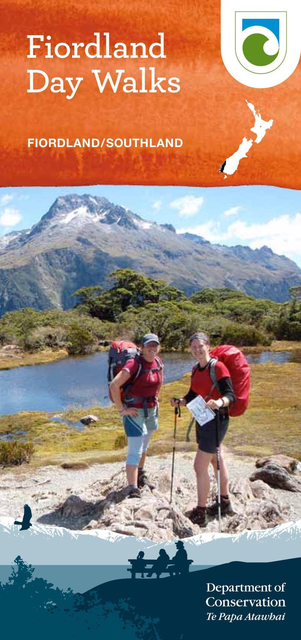
Fiordland Day Walks FIORDLAND/SOUTHLAND
|
|
|
- Abner Lang
- 8 years ago
- Views:
Transcription
1 Fiordland Day Walks FIORDLAND/SOUTHLAND
2 Te Wāhipounamu South West New Zealand World Heritage Area South West New Zealand is one of the great wilderness areas of the Southern Hemisphere. Known to Māori as Te Wāhipounamu (the place of greenstone), the South West New Zealand World Heritage Area incorporates Aoraki/Mount Cook, Westland Tai Poutini, Fiordland and Mount Aspiring national parks, covering 2.6 million hectares. World Heritage is a global concept that identifies natural and cultural sites of world significance, places so special that protecting them is of concern for all people. Some of the best examples of animals and plants once found on the ancient supercontinent Gondwana live in the World Heritage Area. Published by: Department of Conservation Te Rua-o-te-moko/Fiordland National Park Visitor Centre PO Box 29, Te Anau 9640 New Zealand December 2014 Editing and design: Publishing Team, DOC National Office Crown copyright 2014 This publication is produced using paper sourced from well-managed, renewable and legally logged forests.

3 Contents Fiordland National Park 3 Weather 4 History 5 Natural history 6 Formation 7 Fiordland s special birds 8 Marine life 10 Te Rua-o-te-moko/Fiordland National Park Visitor Centre 11 Snow and avalanches 11 Dogs and other pets 11 Walking tracks around Te Anau 13 Te Anau Wildlife Centre 19 Walks around Manapouri 21 Walks from the Milford Road Highway 25 What else can I do in Fiordland National Park? 32 Contact us back cover Left: Mitre Peak overlooking Milford Sound/ Piopiotahi. Photo: Stewart Genery Cover: Key Summit. Photo: Rebecca Hiscock

4 N Milford Sound /Piopiotahi Hollyford Track Hidden Falls MILFORD SOUND Tutuko Valley Humboldt Falls FIORDLAND The Chasm NATIONAL PARK Gertrude Saddle HOLLYFORD Lake Marian Routeburn Track Earland Falls Key Summit Lake Howden Lake Gunn Nature Walk Mirror Lakes Lake Te Anau TE ANAU DOWNS Lake Mistletoe Mavora Lakes 94 Luxmore Hut Kepler Track Control Gates Moturau Hut 95 TE ANAU Lake Manapouri The Monument Rainbow Reach MANAPOURI The Wilderness Lookout 94 2 Manapouri Tracks km Map background by Geographx

5 Fiordland National Park Fiordland National Park, established in 1952, is a vast, remote wilderness and the heart of Te Wāhipounamu South West New Zealand World Heritage Area. It is the largest national park in New Zealand with over 1.2 million hectares of conservation area. People are drawn to Fiordland for the untouched landscapes, extreme wilderness and natural history of the area. It is a place where mountains, rock, ice, lakes, forests and grasslands collide with stunning beauty. Some of the best examples of animals and plants that were once found on the ancient super-continent of Gondwana still exist here. Fiordland is also the home of the Takahē Recovery Programme. This unique bird, the largest living member of the rail family, was once thought to be extinct. After rediscovery of the takahē in the Murchison Mountains in 1948, a special area of 500 km2 was set aside in Fiordland National Park for its conservation. The lakeside township of Te Anau is considered the gateway to Fiordland National Park and offers visitors a fantastic choice of walks, activities, accommodation, and restaurants. An overnight stay here is not to be missed! Kepler Track in snow. Photo: Richard Kinsey 3

6 Weather Fiordland weather is often dramatic and extremely unpredictable. Westerly airflows hitting and rising over the Southern Alps/Kā Tiritiri o te Moana often create heavy rain and snow throughout the region. Rain falls in Fiordland on more than 200 days a year, with around 1,200 mm falling in Te Anau and 8,000 mm in Milford Sound/Piopiotahi, creating thousands of spectacular waterfalls which cascade from sheer-sided mountains. Fine weather will reward you with amazing views, but the true Fiordland visit wouldn t be complete without experiencing it in the rain! Spectacular waterfalls appear after heavy rain. Photo: Stewart Genery 4

7 A boiler from the sawmilling era in Fiordland. Photo: DOC History Fiordland was well known to the Māori, and many legends recount its formation and naming. Demigod Tuterakiwhanoa is said to have carved the rugged landscape from formless rock. Few Māori were permanent residents of the region but seasonal food-gathering camps were linked by well worn trails. Takiwai, a translucent greenstone, was sought from Anita Bay and elsewhere near the mouth of Milford Sound/Piopiotahi. Captain Cook and his crew were the first Europeans to visit Fiordland, and in 1773 spent five weeks in Dusky Sound. Cook s maps and descriptions soon attracted sealers and whalers who formed the first European settlements of New Zealand. From the middle of the 19th century surveyors, explorers and prospectors began to penetrate the unexplored interior of Fiordland. Preservation Inlet boomed briefly in the 1890s after gold was found, but efforts to establish mines, timber mills and farms in Fiordland have generally been short-lived. Quintin McKinnon and Donald Sutherland opened up the Milford Track in 1889 and began guiding tourists through the now world-famous route. Richard Henry, one of the pioneers of threatened species work transferred kākāpō and kiwi to islands in Dusky Sound in the late 1890s and early 1900s. Fiordland National Park was officially constituted in Today it covers over 1.2 million hectares and was declared a World Heritage Area in

8 Fuchsia flowers. Photo: C Rance Natural history Much of Fiordland s forest clings to steep faces of hard rock that is covered by a thin layer of rich, peaty humus and moss. Beech forest is dominant, with red and mountain beech growing around the eastern lakes and in the Eglinton valley. Silver beech is the most widespread of the beech species, sometimes growing in association with podocarp species such as tōtara, rimu and miro. On the western areas, the forest type has a luxuriant understorey of lancewood, tree ferns, coprosma, broadleaf, fungi, mosses and lichens. In the lush wet forests the tree fuchsia is one of New Zealand s few deciduous trees, also being the largest fuchsia in the world. It has orange, papery bark and pendulous, purple flowers. Wood pigeons/kererū feed on the purple fleshy berry known as kōnini. Ferns throughout the forest are lush and varied. Above the 1000 metre bushline, snow tussocks dominate with alpine daisies, buttercups and herbs. 6

9 Rock formations, Mt Titiroa. Photo: S Chesterfield Formation Fiordland contains some of the oldest rocks in New Zealand, predominantly hard crystalline metamorphic rocks like gneiss and schist, and volcanic rocks like granite. Lying close to the alpine fault where two plates of the Earth s crust meet, the area has been folded, faulted, uplifted and submerged many times. Periods of submersion under the sea-bed have created areas of sandstone, mudstone, and limestone seen today at Te Ana-au Caves and on the Hump Ridge. Over the last 2 million years glaciers have at times covered the area, gouging into the rock and creating U-shaped valleys, many of which are now lakes or fiords. Today hundreds of lakes dot the landscape, among them Lake Hauroko, the deepest in New Zealand at 462 metres. Fourteen fiords, some stretching up to 40 kilometres inland, extend from Milford Sound/Piopiotahi in the north to Preservation Inlet in the south. Left: Mt Cook buttercup. Photo: C Rance 7

10 Takahē. Photo: DOC Fiordland s special birds Takahē The flightless takahē (Porphyrio hochstetteri) is a colourful green and blue bird with an impressive red beak and stout legs. Thought to be extinct up until their rediscovery by Doctor Geoffrey Orbell in 1948, the recovery of the species now falls under DOC s Takahē Recovery Programme. The programme focuses on establishing self-sustaining populations in Fiordland and predator-free islands around New Zealand. The Department of Conservation also manages a captive breeding and rearing programme for takahē at Burwood Bush. 8 Kākāpō Fiordland was also once considered to be a stronghold for kākāpō. The kākāpō (or night parrot (Strigops habroptila)) is one of New Zealand s unique treasures and with just over 120 known surviving birds it is listed internationally as a critically endangered species. All birds are now resident on predator-free offshore islands. Large, flightless and nocturnal, the kākāpō is an eccentric parrot which can live for decades. With mottled, moss-green feathers, camouflage is the bird s main form of defence. Kākāpō. Photo: Christine Offiicer

11 Other bird species Visitors are likely to see forest birds like tomtit, brown creeper, grey warbler, fantail, tūī, bellbird and native wood pigeons on day walks in the area. The Eglinton valley is also a stronghold for kākāriki, robin and kākā. The cheeky mountain parrot, the kea, is a regular entertainer at higher altitudes and can often be seen around the Homer Tunnel. Clockwise from top: Kea: Colin Bishop; Tūī: Tui de Roy; Wood pigeon/kererū: Eamonn Ganley; Kākā: Brent Beaven; South Island robin: DOC; Tomtit/miromiro: Brent Beaven. 9

12 Bottlenose dolphins. Photo: Lou Hunt Marine life The marine environment of Fiordland is unique. Heavy rainfall creates a permanent freshwater layer above the sea water within the fiords. Stained by tannins washed out of the vegetation, this layer reduces light, restricting the majority of marine life to the top 40 metres of water depth. This 40 metre band is calm, very clear and relatively warm home to sponges, corals and fish of subtropical, cool water and deep water varieties. The fiords support the world s biggest population of black coral trees about seven million colonies, some of them up to 200 years old. They are home also to brachiopods: primitive clam-like animals which have been bypassed by evolution, remaining unchanged in over 300 million years. Bottlenose dolphins, fur seals, Fiordland crested penguins and little blue penguins are resident in the fiords. Ten marine reserves have been established in Fiordland, protecting all life within them. Around the southern coast, New Zealand s endangered Hector s dolphin can often be seen, as can New Zealand fur seals, little blue and Fiordland crested penguins. For some very lucky visitors, there can be rare opportunities to see whales around the coast. Fur seal. Photo: DO C 10 Black coral. Photo: Steve Wing

13 Fiordland National Park Visitor Centre in Te Anau. Photo: DOC Te Rua-o-te-moko/Fiordland National Park Visitor Centre Situated on the shores of Lake Te Anau on Lakefront Drive, Te Rua-o-te-moko/Fiordland National Park Visitor Centre is open daily, including public holidays. Opening hours vary according to the season. The centre offers: hh hh hh hh hh hh hh Park and conservation information Up-to-date weather and track information Great Walks Booking Office Brochures, maps and books Hut tickets, hunting permits and fishing licences Conservation shop Short film Stepping into Fiordland National Park. Snow and avalanches During the winter and spring the alpine areas of Fiordland are often covered in snow or ice. This may mean tracks are hazardous and/or impassable. Avalanches can and do occur at any time of the year. Always check for up-to-date weather and track conditions before starting your trip. Pick up a copy of Be avalanche alert in Fiordland from the Visitor Centre or visit the website: doc.govt.nz/avalanche-fiordland Dogs and other pets It is an offence under the National Parks Act 1980 to bring dogs or any other introduced animals into Fiordland National Park. Please help protect native wildlife by leaving your pets at home. 11

14 Upukerora R N Fiordland National Park Walking tracks Hut Campsite Picnic site Toilet Shuttle bus Information Centre Shelter Hidden Lakes Lake Te Anau Luxmore Hut (1085m) (54 bunks) Luxmore Caves Limestone Bluffs Brod Bay Boat Trips Rodeo Grounds 94 Fiordland National Park Fiordland National Park Visitor Centre Te Anau Wildlife Centre Dock Bay Control Gates Te Anau 94 To Wilderness Lookout Ivon Wilson Park Kepler Track 95 Moturau Hut (40 bunks) Lake Manapouri Wetland Viewing Platform Rainbow Reach 12 Shallow Bay Hut (6 bunks) Waiau River Manapouri Te Anau Road S.H km
 Lake Manapouri Wetland Viewing Platform Rainbow Reach 12 Shallow Bay Hut (6 bunks) Waiau River Manapouri Te Anau Road S.H. 95 0 1 2 3 km")
15 Walking tracks around Te Anau Te Anau township, nestled on the shores of Lake Te Anau, is the gateway to Fiordland National Park. An ideal place to spend a few days, it offers a wide variety of accommodation, restaurants and services, as well as many commercial operators that can help you explore the park. All track times are one way unless stated otherwise. Track categories Easy access short walk wheelchair accessible Short walk easy walking for up to an hour Walking track gentle walking from a few minutes to a day Great Walk/Easy tramping track well formed track for comfortable overnight tramping/hiking Tramping track mostly unformed but with track directional markers, poles or cairns; backcountry experience required Route navigation and high level backcountry skills and experience required Other symbols Birds nesting Visitor shelter Hut Interp walk Look out Motor boat Picnic site Rowboat Toilets Lake Te Anau and Te Anau township. Photo: DOC 13

16 Visitor Centre to Te Anau Wildlife Centre 10 minutes From the Fiordland National Park Visitor Centre follow the path around the shore of the lake, past the yacht club to the Te Anau Wildlife Centre. The park is open from dawn until dusk and entry is by a gold coin donation. The aviaries and pens that house the birds are set in beautiful grounds with views of the lake. Be sure to visit the takahē enclosure as this is one of the only places where you can see this unique Fiordland bird. Free-flying birds enjoy the trees planted there and the ducks like the water s edge below the boardwalk next to the lake. Visitor Centre to Ivon Wilson Recreation Reserve 15 minutes From Fiordland National Park Visitor Centre walk about 1 kilometre around the lake edge then cross the road to Ivon Wilson Recreation Reserve. This is a 35 hectare reserve, planted with native and exotic trees. There are several paths leading to picturesque Lake Henry, which is stocked with rainbow and brown trout as a children s fishery. Fishing licences are available from the Fiordland National Park Visitor Centre. The is also a mountain bike track located in the reserve enquire at the visitor centre for more information. Toilets are available near the entrance. 14 Luxmore Hut on the Kepler Track. Photo: DOC

17 Visitor Centre to Control Gates 50 minutes Follow the path from the Fiordland National Park Visitor Centre around the edge of the lake, passing through the Wildlife Centre. Excellent lake and mountain views are enjoyed as the track crosses open land below the golf course. The Control Gates regulate water flows between lakes Te Anau and Manapouri for the West Arm hydroelectric power station. They mark the start of the Kepler Track, a 3 4 day walk. A toilet is available at the car park and there is another toilet 5 minutes from the Control Gates on the track to Dock Bay. Control Gates to: Dock Bay (Kepler Track) 1 hour return Brod Bay (Kepler Track) 3 hours return Luxmore Hut (Kepler Track) 8 10 hours return From the Control Gates the Kepler Track (a Great Walks track) follows the lake edge through mountain and red beech forest. In spring the yellow-flowering kōwhai and scented orchids are attractive. Dock Bay is suitable for swimming and has toilet facilities. Continued >> 15

18 Swing bridge over the Waiau River at Rainbow Reach. Photo: Pania Dalley The track continues around the lake for another hour to Brod Bay. From here it ascends steeply through mountain and silver beech forest, passes under towering limestone bluffs, and climbs above the bushline to Luxmore Hut. This strenuous, full-day walk provides impressive views of Lakes Te Anau and Manapouri, and the Te Anau basin. Brod Bay to Te Anau (Kepler Track) 3 4 hours A local water taxi will take you from Te Anau across the lake to Brod Bay. From Brod Bay a pleasant walk on the Kepler Track beside the lake will lead you back to Te Anau via the Wildlife Park. The Visitor Centre has departure times and rates of the water taxi. Luxmore Hut to Te Anau (Kepler Track) 4 5 hours A helicopter can drop you off at Luxmore Hut so you can walk back down the mountain into Te Anau. There are beautiful views over the Te Anau basin on a nice day. Contact the Visitor Centre for details on helicopter availability and rates. This trip is weather dependent. 16
 3 4 hours A local water taxi will take you from Te Anau across the lake to Brod Bay.")
19 Control Gates to Rainbow Reach (Kepler Track) 2 hours 30 minutes Follow the terraces of the Waiau River along the Kepler Track through red and mountain beech forest. An area of mānuka shrubland marks the home of early runholder Jack Beer who during summer drove his sheep onto Mt Luxmore to graze. There is a swing bridge to cross over the Waiau River to get to Rainbow Reach. A shuttle bus service back to Te Anau operates during the summer months. Rainbow Reach to Shallow Bay or Moturau Hut (Kepler Track) 3 3 hours 30 minutes return Rainbow Reach is 12 km from Te Anau on the Manapouri/ Te Anau Highway. To access this part of the Kepler Track, cross the swing bridge beside the car park, then turn left. The track is gently undulating and wanders through mountain beech forest with some great river views. Some scenes in the Lord of the Rings movies were filmed near this part of the river. Further along cross a kettle bog then continue to the shores of Lake Manapouri. The Moturau and Shallow Bay Huts are near the lakeshore and offer shelter and toilet facilities. 17
 3 3 hours 30 minutes return Rainbow Reach is 12 km from Te Anau on the Manapouri/ Te Anau Highway.")
20 Visitor Centre to Upukerora River 3 hours return Follow the Te Anau lakeshore toward the main shopping centre; continue along the footpath to the boat harbour at Bluegum Point (30 min). For a longer trip (3 hr return) continue round the lake front, past the rodeo grounds to the mouth of the Upukerora River. Return either the same way, or follow the gravel road alongside the river to the Te Anau Milford Highway and back into town. Please be careful as cars travel quickly on this road. Although not in Fiordland National Park, both these walks provide pleasant views of the Murchison Mountains and Lake Te Anau. The Wilderness Lookout 5 minutes The Wilderness is situated on SH94, minutes drive from Te Anau towards Mossburn. The track is wheelchair accessible, and leads to a viewing platform over ancient, low and slow-growing Halocarpus bidwilli bog pine forest. Although not in Fiordland National Park, the 360 views of the Takitimu Mountains and foothills, Fiordland National Park and farmland, are spectacular. 18 The Wilderness Scientific Reserve. Photo: Andy Wards

21 Bellbird/koromiko. Photo: Brent Beaven Te Anau Wildlife Centre The Te Anau Wildlife Centre is set on the shores of Lake Te Anau, and is a 10 minute walk from the Te Rua-o-te- Moko/Fiordland National Park Visitor Centre. The centre is open from dawn to dusk and can cater for guided tours if booked in advance through the Visitor Centre. Entry is free, but a gold coin donation is appreciated. The rare flightless takahē are the stars of the Wildlife Centre and meeting these prehistoric-looking characters are a must do for Fiordland visitors. For a special opportunity to observe these unique birds, join a DOC ranger as they feed them each morning. Confirm feeding times at the Visitor Centre. The birds held in aviaries here have either been injured and cannot survive in the wild or they have been involved in captive rearing programmes. The injured birds are rehabilitated and, if possible, released back into the wild when they are strong enough. An added bonus for visitors is the variety of free-flying birds seen around the centre. Many are attracted by the food available from the native trees and shrubs that have been planted around the park. Native pigeons, tūī, silvereyes, grey warblers, starlings, tomtits, bellbirds and pied and black fantails appear from time to time, often feeding in the bush at the lake s edge. Small groups of greenfinches and chaffinches also visit at intervals, while both harriers and, less commonly, falcons make occasional appearances, attracted by other birds. As well as brown teal, mallard, grey and paradise ducks, you may see black-backed gulls, black-billed gulls, little shags and, occasionally, the rare crested grebe or the brillant blue of the kingfisher. 19
22 N Buncrana Island Shallow Bay Rona Island Ruby Reach Waiau River Lake Manapouri Mahara Island Supply Bay Stockyard Cove Circle Cove George Bay Surprise Bay Frazers Beach Manapouri 95 Pearl Harbour Wai-waiata Stream Hope Arm Hut (12 bunks) The Monument Hope Arm Back Valley Lake Rakatu Track Garnock Burn Circle Track Back Valley Track Waiau River Back Valley Hut (4 bunks) Stinking Creek Garnock Burn Lake Rakatu 20 Fiordland National Park km Track Hut Camp Site View Point
23 Walks around Manapouri These tracks are accessed from Pearl Harbour in Manapouri via a 5 minute boat journey across the Waiau River. Access To access these walking tracks in Fiordland National Park, cross the Waiau River at Pearl Harbour to the jetty on the opposite shore. There are water taxis available, or row boats can be hired. Please contact the Manapouri Store for more information on these options. Circle Track 3 3 hours 30 minutes From the jetty follow the riverside track for 15 minutes to a track junction. Turn left and head up the hill to the viewpoint overlooking the lake. This part of the track is rather steep and slippery so you will need to take care. The track then descends down the ridgeline to the Hope Arm Track. Turn right to return to Pearl Harbour which takes about 1 hour. Turn left for Hope Arm or Back Valley Hut options. Views of the lake from Circle Track. Photo: DOC 21
24 Pearl Harbour to Hope Arm 4 6 hours return From the jetty follow the track by the Waiau River for 15 minutes. A signposted junction indicating the Circle Track is to the left carry on straight ahead. There are good views of the Manapouri boat harbour from the terraces above the river. The track follows close to the lake edge in several places and there are some unofficial tracks that lead to the lake itself. From here the track climbs gently to the spur where the Circle Track rejoins the main track. Continue straight ahead again through the diverse understorey of plants until reaching the Back Valley/Hope Arm Hut junction. Turn right for Hope Arm and proceed through a narrow neck of forest on boardwalk over swampland. Cross the bridge over the Garnock Burn and shortly you will descend on to Hope Arm Beach. The hut is sited at the far end of the beach. Pearl Harbour to Back Valley Hut 4 5 hours return Take the left branch at the Hope Arm/Back Valley turnoff as described above. The track passes through beech and podocarp forest and a stand of ribbonwood before emerging into some small clearings, where the hut is situated. After heavy rain this part of the track can be quite muddy. From the hut it is possible to do a side trip up to Lake Rakatu. The trip takes an extra 2 hours return and the track is very muddy as it follows the creek to the lake. Back Valley Hut. Photo: DOC 22
25 Pearl Harbour return via Hope Arm & Back Valley Huts 6 7 hours This is a loop walk visiting both huts. See above for track description to Hope Arm Hut, then take the track located behind the hut to Back Valley Hut. It is an easy grade to the Garnock Burn which is spanned by a three wire bridge. See above for details on the track from Back Valley Hut to Pearl Harbour. The Monument Track 1 hour 30 minutes 2 hours return A water taxi or private boat is required to reach the start of the track, 2 km north of the Hope Arm Hut. From here it is a short, but challenging, 290 metre climb to The Monument summit. From the beach, the track climbs steeply through forest onto the ridge before reaching the bushline. Extreme caution is advised as there are exposed sections with crumbling rock and narrow ledges. At one point there is a chain anchored into the rock to help you. From the top there are spectacular views of Lake Manapouri and the surrounding mountains. Stockyard Cove Track 45 minutes 1 hour return Travel by water taxi or private boat to Stockyard Cove at the western entrance to Hope Arm. Two tracks lead from this point. The first heads west to West Beach where there are nice views of Lake Manapouri. The second passes through ancient podocarp forest, climbing briefly until reaching the high bluff waterfalls and then descending through mountain beech forest to the lake edge. This track is also known as the Waterfall Track. It is advisable to return to Stockyard Cove following the same track as the foreshore is rocky, slippery and parts of it can be underwater if the lake level is high. Frazers Beach 30 minutes The views from the beach of the national park are awe-inspiring, especially at sunset. Walk along the beach, or the track parallel to the beach. The track starts and finishes from Pearl Harbour or at the road entrance just north of Manapouri township. 23
26 Milford Sound /Piopiotahi Hollyford Track Hidden Falls Hut /Whakat Hollyford Milford Sound Lookout Walk Milford Foreshore Walk Humboldt Falls ipu Milford N Hidden Falls Gertrude Saddle Rive Gunn s Camp uka Ka T The Chasm r Lake Marian The Divide Routeburn Track Mackenzie Hut Earland Falls Howden Hut Key Summit Fiordland National Park Lake Gunn Lake Gunn Nature Walk 94 Knobs Flat Mirror Lakes Ri ve r Track lin t on Route Eg Information Centre Hut Te Anau Downs Camp site Lake Te Anau Lake Mistletoe View point Toilet Shelter Accommodation Dump station Petrol Telephone Boat cruise Te Anau km
27 Walks from the Milford Road Highway Tracks from the Milford Road will introduce you to some of the most spectacular alpine and forest scenery in New Zealand. The drive itself is magnificent. Take the opportunity to delve deeper into the wilderness other than simply seeing it from your car. Tips for travellers on the Milford Road hh hh hh hh hh hh hh There are no petrol stations en route to Milford Sound. Allow a minimum of 2 2 hr 30 min to drive from Te Anau to Milford. Please check road conditions during winter and spring. Snow chains may need to be carried. There is no cellphone coverage outside of Te Anau. It is a steep and windy, mountainous road. Please drive to the conditions. There are 10 DOC campsites between Te Anau and The Divide. Please do not feed the kea. Key Summit. Photo: Emily Funnell 25
28 Lake Mistletoe 45 minutes return Lake Mistletoe is reached by an attractive forest walk at Te Anau Downs. The entrance is signposted opposite the Fiordland National Park Lodge complex. Mirror Lakes 10 minutes A good place to stretch your legs during the drive to Milford Sound. Small lakes seen from the wheelchairaccessible boardwalk provide outstanding reflective views of the Earl Mountains. Waterfowl and wetland plants can be seen against a backdrop of beech forest. Interpretation panels provide information on local wildlife. Lake Gunn Nature Walk 45 minutes return (Access from Cascade Creek car park.) This easy 45 minute loop walk is suited to all ages. It is wheelchair accessible and passes through red beech forest and birdlife typical of the Eglinton valley. Side trips can be made to several lake beaches and sheltered fishing spots. Key Summit 3 hours return From The Divide car park follow the Routeburn Track (a Great Walks track) for about an hour to the track to Key Summit. From here it is a 20 minute climb to Key Summit, with panoramic views over the Humboldt and Darran Mountains. A selfguided alpine nature walk passes a range of native vegetation: beech forest, subalpine shrublands, alpine tarns and bogs. Birdlife is prolific and tomtits, robins, wood pigeons and bellbirds are commonly seen. If you only have time for one walk on your drive to Milford Sound, and the weather is fine, this track is well worth the effort! 26 Lake Howden 3 hours return From The Divide car park follow the Routeburn Track through silver beech forest to the Key Summit turn off (see above). From here it is a short descent to Lake Howden and the Howden Hut.
29 Earland Falls 6 hours return From The Divide car park follow the Routeburn Track to Howden Hut (1 hr 30 min). From here take the track to Mackenzie Hut the falls are halfway between Howden and Mackenzie Huts. Clearings give excellent views of the Hollyford valley. Earland Falls are 174 metres high and originate from Lake Roberts. Please check track conditions at the Fiordland National Park Visitor Centre during the snow/avalanche season (winter and spring). These walks are in avalanche risk areas check conditions with the Visitor Centre before your trip. Earland Falls, Routeburn Track. Photo: Keri Moyle ( 27
30 Lake Marian Falls 20 minutes return Lake Marian 3 hours return The car park is 1 kilometre down the unsealed Hollyford Road. From here cross the swing bridge and continue to the spectacular series of waterfalls which are viewed from the gantry hugging the side of the steep bank. From the gantry the track becomes steep and sometimes muddy during the ascent to Lake Marian. This beautiful alpine lake is situated in a hanging valley, surrounded by mountains with magnificent reflections if the weather is calm. Do not walk around the lake edge during the snow/ avalanche season (winter and spring). Humboldt Falls 30 minutes return This walk starts from the end of the unsealed Hollyford Road. A well-graded track takes you on a short climb through rainforest to the lookout of the impressive Humboldt Falls. Hidden Falls 4 6 hours return Leave your car at the Hollyford Road end and cross the swing bridge over Humboldt Creek onto the Hollyford Track. The track follows the Hollyford River/Whakatipu Kā Tuka and offers occasional views of the Darran Mountains. At Hidden Falls Creek the track passes Sunshine Hut, run by 28 View of Milford Sound/Piopiotahi from the Gertrude Saddle. Photo: Sally Chesterfield
31 Hollyford Valley Guided Walks, and continues upstream to the swing bridge. Take the rough track to the right of the bridge to view Hidden Falls. Hidden Falls Hut (12 bunks) is a further 20 minutes along the track over the bridge. Gertrude Saddle Route 4 6 hours return The car park is signposted shortly before the eastern portal of the Homer Tunnel. From the car park the marked route meanders up the valley through spectacular alpine vegetation. After rain there are some creek crossings so expect to get wet feet. There are no markers above the bushline, so alpine navigational skills are essential. Unfortunately trampers create misplaced rock cairns be sure to follow your own judgement and use a topographical map (NZ Topo50 sheet CB09 Hollyford). From the head of the valley the route leads up to the saddle. Cross the base of the waterfall and sidle across the slopes towards Black Lake. From here parts of the track are very steep and not suitable for those with limited tramping experience, or a dislike for heights. The track goes up steep rock slabs and is treacherous when wet or frosty there are steel cables to assist you. From the head of the valley continue up through the boulders to the saddle. Breathtaking views of the valley and part of Milford Sound/Piopiotahi can be seen. This is an alpine route and is subject to avalanches after snow. Please check with the Fiordland National Park Visitor Centre for track conditions before starting, whatever the season. 29
Kepler. Duration: 3 4 days Distance: 60 km (loop) Great Walks season: 27 October 2015 27 April 2016
 Great Walks season: 27 October 2015 27 April 2016") Kepler Track Duration: 3 4 days Distance: 60 km (loop) Great Walks season: 27 October 2015 27 April 2016 Kepler Track From the beech-forested shorelines of lakes Te Anau and Manapouri, to tussockcovered
Kepler Track Duration: 3 4 days Distance: 60 km (loop) Great Walks season: 27 October 2015 27 April 2016 Kepler Track From the beech-forested shorelines of lakes Te Anau and Manapouri, to tussockcovered
Benton MacKaye Trail - Section 2. Three Forks (FS 58) to GA. Highway 60. 11.4 miles
 to GA. Highway 60. 11.4 miles") General Benton MacKaye Trail - Section 2 Three Forks (FS 58) to GA. Highway 60 11.4 miles This is the longest and most remote section of the Benton MacKaye Trail (BMT) east of GA 5. It follows the Appalachian
General Benton MacKaye Trail - Section 2 Three Forks (FS 58) to GA. Highway 60 11.4 miles This is the longest and most remote section of the Benton MacKaye Trail (BMT) east of GA 5. It follows the Appalachian
Margherita Peak, Mt. Stanley, 8 day trek
 RWENZORI TREKKING Margherita Peak, Mt. Stanley, 8 day trek This 8 day itinerary will take you deep into the Rwenzori Mountains to Margherita Peak, the tallest peak on Mt. Stanley and Africa s third highest
TIMARU BOYS & GIRLS HIGH SCHOOL Aviation Course
 TIMARU BOYS & GIRLS HIGH SCHOOL Aviation Course INTRODUCTION... AN AVIATION FLYING OPPORTUNITY Timaru Boys and Timaru Girls, in conjunction with South Canterbury Aero Club are very pleased to offer an
Climate, Vegetation, and Landforms
 Climate, Vegetation, and Landforms Definitions Climate is the average weather of a place over many years Geographers discuss five broad types of climates Moderate, dry, tropical, continental, polar Vegetation:
Four-wheel driving in Mackenzie/ Waitaki
 Protect plants and animals Remove rubbish Bury toilet waste Keep streams and lakes clean Take care with fires Camp carefully Keep to the track Consider others Respect our cultural heritage Enjoy your visit
Rimutaka Incline activity cards
 Rimutaka Incline activity cards To the supervisor As you lead your group on an exploration of the Rimutaka Incline, please ensure that the group stays together, treats the environment respectfully and
BEECH MAST RESPONSE 2014
 BEECH MAST RESPONSE 2014 Heavy seeding in our native forests this year will drive high rodent and stoat numbers that prey on endangered birds. Battle for our Birds is a predator control response to protect
1. Which city is the capital of New Zealand? a) Sydney; b) Wellington; c) Auckland.
 Sydney; b) Wellington; c) Auckland.") 1 Quick quiz Test your knowledge of New Zealand. 1. Which city is the capital of New Zealand? a) Sydney; b) Wellington; c) Auckland. 2. What are the native people of New Zealand called? a) Aborigine; b)
1 Quick quiz Test your knowledge of New Zealand. 1. Which city is the capital of New Zealand? a) Sydney; b) Wellington; c) Auckland. 2. What are the native people of New Zealand called? a) Aborigine; b)
PROMOTING NEW ZEALAND S PREMIUM CYCLE TOURISM EXPERIENCES TO THE WORLD
 Nga Haerenga, The New Zealand Cycle Trail Product Directory Prospectus 2012/2013 Photo: Hawke s Bay Trails PROMOTING NEW ZEALAND S PREMIUM CYCLE TOURISM EXPERIENCES TO THE WORLD Photo: Hawke s Bay Trails
NATURAL REGIONS OF KENTUCKY
 NATURAL WONDERS As you travel around Kentucky taking pictures, you are excited by what you see. Kentucky offers diverse and amazing sights. The Six Regions In the West, you see the Mississippi River, the
Milford Track. Duration: 4 days Distance: 53.5 km (one way) Great Walks season: 27 October 2015 27 April 2016
 Great Walks season: 27 October 2015 27 April 2016") Milford Track 4 days 53.5 km (one way) Great Walks 27 October 2015 27 April 2016 Milford Track 1000 m ElEvaTion profile & Track guide Experience the finest walk in the world as you retrace the steps of
Milford Track 4 days 53.5 km (one way) Great Walks 27 October 2015 27 April 2016 Milford Track 1000 m ElEvaTion profile & Track guide Experience the finest walk in the world as you retrace the steps of
PRESENTS: Brisbane Return via. the Outback and Cairns Self Guided Tour. www.bikeroundoz.com
 PRESENTS: Brisbane Return via the Outback and Cairns www.bikeroundoz.com Sunshine Coast & Noosa Sunshine Coast & Noosa This area has one of the most spectacular hinterlands in the country incorporating
Adventure Activity Sample Itinerary. I - Itinerary Full Day Adventure Everglades Safari Park
 Adventure Activity Sample Itinerary I - Itinerary Everglades Safari Park The most complete attraction in the Everglades! Fun for the entire family, including exciting airboat eco-adventure tours and alligator
TAIRAWHITI GREAT RIDES PROPOSAL
 TAIRAWHITI GREAT RIDES PROPOSAL RAUKOKORE CHURCH INTRODUCTION In partnership, Gisborne District Council, Opotiki District Council and Tourism Eastland promote the Eastland Traverse and East Cape Tour as
Kakapo Recovery Plan 1996-2005
 Kakapo Recovery Plan 1996-2005 Threatened Species Recovery Plan No.21 Kakapo Management Group Department of Conservation P.O. Box 10-420 Wellington New Zealand CONTENTS 1. Background 5 2. Distribution
Chapter 18 Introduction to. A f r i c a
 Chapter 18 Introduction to A f r i c a Ch. 18:1 Landforms & Resources 1. Africa s shape & landforms are the result of its location in the southern part of the ancient supercontinent of. Pangaea Over thousands
Land Specialties is North Georgia s premier development company for mountain lifestyle communities. Whether you imagine life on the lake, the links,
 Land Specialties is North Georgia s premier development company for mountain lifestyle communities. Whether you imagine life on the lake, the links, or the lofty peaks, we bring your vision into clear
Kancamagus Highway Guide
 Kancamagus Highway Guide The Kancamagus Highway. Undoubtedly the most scenic route in Mountain Country, the Kancamagus (k?an-c?a-mä-g?us) Highway (Rt. 112) stretches from the Pemigewasset River at Lincoln
3.1. Succession, Recovery, and Renewal in Natural Communities. A35 Starting Point. What Happens to a Vacant Lot?
 3.1 Succession, Recovery, and Renewal in Natural Communities Here is a summary of what you will learn in this section: Ecosystems change in predictable ways known as succession. Ecosystems can establish
Garden design and restoration - rebuilding hystorical places Yvoire France
 Volume 17(3), 118-122, 2013 JOURNAL of Horticulture, Forestry and Biotechnology www.journal-hfb.usab-tm.ro Garden design and restoration - rebuilding hystorical places Yvoire France Szekely G. 1 * 1 Banat
Kermadec. Ocean Sanctuary
 Kermadec Ocean Sanctuary Kermadec Ocean Sanctuary, New Zealand Coral Sea Marine Reserve, Australia Pacific Remote Islands National Marine Monument, United States Proposed Pitcairn Marine Reserve, United
GM IFMGA 2013 in Huaraz Peru
 (AGMP) GM IFMGA 2013 in Huaraz Peru SUGGESTIONS FOR OPTIONAL PROGRAM IN THE REGION OF ANCASH PRIOR TO GENERAL MEETING (4 OR 6 DAYS) Two programs for the time between 9 th and 14 th October 2013 Coordinator
Chapter 3 Communities, Biomes, and Ecosystems
 Communities, Biomes, and Ecosystems Section 1: Community Ecology Section 2: Terrestrial Biomes Section 3: Aquatic Ecosystems Click on a lesson name to select. 3.1 Community Ecology Communities A biological
Fiordland Discovery Product Manual
 Fiordland Discovery Product Manual Version: 8 October 2015. Valid to 20 April 2017. Summary Milford Sound Overnight Cruise bookings are available from 1 FEBRUARY 2016 undl 31 March 2016 (note the boat
Planning Your Trip to Mount Rainier National Park!
 Planning Your Trip to Mount Rainier National Park! Grade Level: 5 12+ Overview 100 Learner Objectives: Students will: Recognize how to interpret maps and guidebooks Recognize some interesting places to
Floods are too much water on normally dry land. Rivers can flood after heavy rain has fallen over a long period of time. River flooding can last
 Floods are too much water on normally dry land. Rivers can flood after heavy rain has fallen over a long period of time. River flooding can last weeks or longer. River floods usually occur slowly enough
Fun, famous, effective fitness and weight loss. With a camp near you.
 Fun, famous, effective fitness and weight loss. With a camp near you. California Florida Texas New York North Carolina Pennsylvania Hawaii Wisconsin Vancouver UK Family Camp 1) Wellspring Texas Set in
Solar Heritage & Terror Boat Trips
 Chichester Harbour Solar Heritage & Terror Boat Trips April 2013-March 2014 Chichester Harbour Conservancy for land, for water, for all 1 SOLAR HERITAGE is a 14 metre solar powered catamaran. She can carry
Temporary event application form Lake Karapiro
 If you require assistance with your booking or forms, help can be obtained from the following: Mighty River Domain at 07 827 4178 info@lakekarapiro.co.nz www.lakekarapiro.co.nz Waikato Regional Council
Excerpt of FSM 2710 issued 09-17-2008. 2713.1 Liability and Insurance. 1. Inherent Risks.
 Excerpt of FSM 2710 issued 09-17-2008 2713.1 Liability and Insurance 1. Inherent Risks. a. Engaging in most activities on National Forest System lands involves inherent risks. Swimming, boating, skiing,
Sullivan s Island Bird Banding and Environmental Education Program. Sarah Harper Díaz, MA and Jennifer Tyrrell, MS
 Sullivan s Island Bird Banding and Environmental Education Program Sarah Harper Díaz, MA and Jennifer Tyrrell, MS I. Introduction The Sullivan s Island Bird Banding and Environmental Education Program
Four Short Walks From the Mill
 Four Short Walks From the Mill With directions, duration and length of walk www.ratonera.com (0034) 958 339 560 There are steep sections on most of these walks so please wear boots or stout shoes. A stick
Sydney Airport District
 Sydney Airport Business District 1 0 The abd: where business takes off This brand new commercial precinct, Sydney Airport Business District, features a combination of modern office towers, retail facilities,
Map reading made easy
 Map reading made easy What is a map? A map is simply a plan of the ground on paper. The plan is usually drawn as the land would be seen from directly above. A map will normally have the following features:
Focus On You Photography TRT from Brockway Summit to Watson Lake
 Tahoe Rim Trail (TRT) From Hwy 267 (Brockway Summit) west to Watson Lake (Strong Intermediate Advanced) This trail is very demanding. It is almost 2100 ft. of climbing. The trail is up and down, up and
M-86 2013. Right to Roam
 M-86 2013 Right to Roam Hiking and Skiing Hiking and skiing are freely permitted in open countryside in summer and winter alike. You can follow hiking trails, private roads and groomed ski trails or strike
Grade Level Content Expectations addressed: Activities: Schedule of Field Trip Activities at the Detroit Zoo 8:15 am Board Bus at School
 Title: Comparing and Contrasting Ecosystem Biodiversity Submitted by: Tracy Ortiz Email: tracy.ortiz@att.net School: Coffey K-8 Educational Learning Community Date: May 12, 2010 Target Grade: 6 Duration:
NEZ PERCE-CLEARWATER FORESTS
 United States Department of Agriculture Forest Service NEZ PERCE-CLEARWATER FORESTS Fish Creek Meadows A Year-Round Playground For Idaho and the Northwest Fish Creek Meadows Year-round Recreation For Everyone
Hardangervidda. Great hiking & fishing High mountain cruise at Møsvatn. Moose safari
 Mountain village at the foot of Hardangervidda, Telemark Hardangervidda Northern Europe s largest Mountain plateau Great hiking & fishing High mountain cruise at Møsvatn Telemark s largest lake Moose safari
It s always summer in the Canary Islands!
 Discovering Spain - Sports & Nature beach holiday - Canary Islands - Gran Canaria - La Gomera - Parador Cruz de Tejada - Parador El Hierro - Parador La Gomera Parador La Palma - Parador Las Cañadas del
Walking and cycling tracks. in Aoraki/Mount Cook National Park
 Walking and cycling tracks in Aoraki/Mount Cook National Park Contents Welcome to Aoraki/Mount Cook National Park 1 Be prepared 3 Walks from the village and campground 5 Freda du Faur 9 Walks map 10 Village
MANAGEMENT DIRECTION STATEMENT May, 1999
 Kootenay District AAGEET DIRECTIO STATEET ay, 1999 for Akamina-Kishenina Provincial Park inistry of Environment Lands and Parks BC Parks Division Table of Contents I. Introduction A. Setting and Context...1
Voyage to the East Coast + Ile aux Nattes
 Voyage to the East Coast + Ile aux Nattes Discovery of Madagascar Voyage to the East Coast + Ile aux Nattes 8 night / 9 days Theme: Adventure and Beach Madagascar Travelling to Madagascar is above all
The Geology of the Marginal Way, Ogunquit, Maine
 Geologic Site of the Month February, 2002 The Geology of the Marginal Way, Ogunquit, Maine 43 14 23.88 N, 70 35 18.36 W Text by Arthur M. Hussey II, Bowdoin College and Robert G. Marvinney,, Department
The Nature Conservancy Offering Protected Lands for Sale in the Adirondacks Sustainable Forestry to Continue
 News release For immediate release August 21, 2008 Contact: Connie Prickett, (518) 576-2082 x162, cprickett@tnc.org The Nature Conservancy Offering Protected Lands for Sale in the Adirondacks Sustainable
Branscombe West Cliff and beach chalets
 BRANSCOMBE Devon from www.discoverbutterflies.com the website for the book Discover Butterflies in Britain D E Newland 2009 Branscombe West Cliff and beach chalets Branscombe is a seaside beauty spot on
Bressay Community Council Area Statement
 Bressay Community Council Area Statement See Bressay Proposals Map Background 1.1 The island of Bressay is 7 miles (11 km) long by 3 miles (5 km) wide with a current population of approximately 400. The
MAQUINNA PROVINCIAL PARK
 MAQUINNA PROVINCIAL PARK PURPOSE STATEMENT AND ZONING PLAN February 2003 MAQUINNA PROVINCIAL PARK Purpose Statement and Zoning Plan Primary Role The primary role of Maquinna Provincial Park is to protect
GRINDELWALD SKI TOURING WEEK 2016 TRIP NOTES
 GRINDELWALD SKI TOURING WEEK 2016 TRIP NOTES Grindelwald Ski Touring Week 2016 Trip Notes All material Copyright Adventure Consultants Ltd 2015/16 Switzerland is home to some of the world s best winter
Kamchatka. Russian land of bears and fire
 Kamchatka Russian land of bears and fire A land of spectacular wild beauty, with dozens of smoking volcanoes Rivers, creeks and lakes crowded with salmons. Forests of birch and conifer and in another part
Background Information: The Mamquam River Floodplain Restoration Project
 Background Information: The Mamquam River Floodplain Restoration Project The Mamquam River Floodplain Restoration project is being undertaken in partnership with the Squamish River Watershed Society, Fisheries
These Maps Are For The Birds
 These Maps Are For The Birds Students will study New York State Breeding Bird Atlas maps to learn where different bird species nest and how their distributions have changed over time. Objectives: Students
REPORT TO REGIONAL WATER SUPPLY COMMISSION MEETING OF WEDNESDAY, SEPTEMBER 4, 2013 LEECH WATER SUPPLY AREA RESTORATION UPDATE
 Making a difference... together Agenda Item #9 REPORT #RWSC 2013-17 REPORT TO REGIONAL WATER SUPPLY COMMISSION MEETING OF WEDNESDAY, SEPTEMBER 4, 2013 SUBJECT LEECH WATER SUPPLY AREA RESTORATION UPDATE
Troop 476 Reservations Summary
 Document Overview This documents summarizes the reservation process for the high-adventure treks and other treks that Troop 476 goes on. High Adventure or Week Long Summer Camps When To Make Camp Camp
9e) 100m past Dynevor Arms Pub go past lone bungalow on L then turn L along designated footpath. Emerge on main Rd (A469) turn L, then after 30m
 100m past Dynevor Arms Pub go past lone bungalow on L then turn L along designated footpath. Emerge on main Rd (A469) turn L, then after 30m") 9e) 100m past Dynevor Arms Pub go past lone bungalow on L then turn L along designated footpath. Emerge on main Rd (A469) turn L, then after 30m cross rd (CAREFUL) and head up obvious footpath opposite
9e) 100m past Dynevor Arms Pub go past lone bungalow on L then turn L along designated footpath. Emerge on main Rd (A469) turn L, then after 30m cross rd (CAREFUL) and head up obvious footpath opposite
The Wonderful World of Wetlands BINGO
 The Wonderful World of Wetlands BINGO Time: 10-15 minutes to create Bingo board; 5-10 minutes to play one-round of Bingo Scituate Reservoir Watershed Education Program 17 Smith Ave Greenville, RI 02828
PROGRAM: Maniti Pacaya Voyage [7D/6N]
![PROGRAM: Maniti Pacaya Voyage [7D/6N]](/thumbs/26/7735210.jpg "PROGRAM: Maniti Pacaya Voyage [7D/6N]") MANITI CAMP EXPEDITIONS Jr. Huallaga 240 2do Piso, Iquitos, Perú RUC: 10054007677 Web : http://www.manitiexpeditions.com Email : reservations@manitiexpeditions.com Telephone Perú: (+51) 1-707-0441 Telephone
MANITI CAMP EXPEDITIONS Jr. Huallaga 240 2do Piso, Iquitos, Perú RUC: 10054007677 Web : http://www.manitiexpeditions.com Email : reservations@manitiexpeditions.com Telephone Perú: (+51) 1-707-0441 Telephone
art+community+adventure Alta Garrotxa in Spanish Pyrenees For young people aged 13 to 19
 what will you do to change the world? SUSTAINABILITY SCHOOL SUSTAINABILITY SCHOOL art+community+adventure Alta Garrotxa in Spanish Pyrenees For young people aged 13 to 19 Sustainability School Alta Garrotxa
Using Aerial Photography to Measure Habitat Changes. Method
 Then and Now Using Aerial Photography to Measure Habitat Changes Method Subject Areas: environmental education, science, social studies Conceptual Framework Topic References: HIIIB, HIIIB1, HIIIB2, HIIIB3,
Communities, Biomes, and Ecosystems
 Communities, Biomes, and Ecosystems Before You Read Before you read the chapter, respond to these statements. 1. Write an A if you agree with the statement. 2. Write a D if you disagree with the statement.
Marchand Provincial Park. Draft Management Plan
 Marchand Provincial Park Draft Management Plan Marchand Provincial Park Draft Management Plan Table of Contents 1. Introduction... 3 2. Park History... 3 3. Park Attributes... 4 3.1 Natural... 4 3.2 Recreational...
Region of Georgia : Mountains
 Region of Georgia : Mountains Northern most region of GA Cold weather in the winter Brasstown Bald is the highest point in Georgia Lots of creeks and streams High above sea level Poor soil for farming
Local families homes. Eat: breakfast - at guest house Lunch lunch box Dinner with family
 Itinerary Description Accommodation 8-06, Monday - Osh Meeting from the airport Manas. Fly to Osh. Same day. Depending on time of flights arrival and departure to Osh could be possible take photos of the
Mud in the Water. www.agclassroom.org/ok. Oklahoma Academic Standards. Objective. Background. Resources Needed. Activities
 Mud in the Water Objective Students will learn about soil erosion and water pollution by building a demonstration model from pop bottles and observing the movement of pollutants from soil into water. Background
Discover Arthur's Pass. A guide to Arthur's Pass National Park and village
 Discover Arthur's Pass A guide to Arthur's Pass National Park and village Contents Welcome to Arthur s Pass 1 The historic east-west journey 3 Changeable weather four seasons in one day 8 Dynamic landscape
Functional Skills English Assessment Reading Level 2
 Learner name Learner registration number Learner signature Centre Assessment date Functional Skills English Assessment Reading Level 2 NOCN USE ONLY Question Mark 1 2 3 4 5 6 7 8 9 10 Total Instructions
p. 1 Our Adventure to Peek-a-boo and Spooky Slot Canyons Written by a city dweller with no backcountry experience
 p. 1 Our Adventure to Peek-a-boo and Spooky Slot Canyons Written by a city dweller with no backcountry experience p. 2 Members of the trip 1. 45 year-old male. Relatively athletic. Play ping-pong; can
INSTRUCTOR TRAINING SCHEME APPLICATION PACK
 INSTRUCTOR TRAINING SCHEME APPLICATION PACK Mendip, Lyncombe Drive, Churchill, North Somerset, BS25 5PQ Call 01934 834 877, search www.mendip.me or email info@mendip.me INSTRUCTOR TRAINING SCHEME Mendip
Where Do Birds Live?
 Objectives You will learn about 1) where birds build nests, 2) the materials they use, 3) different nest characteristics and 4) how to observe nesting activity. Introduction Birds hatch their young in
The Basics of Navigation
 The Basics of Navigation Knowledge of map reading and the use of the compass is an indispensable skill of bushcraft. Without this skill, a walker is a passenger and mere follower on a trip. To become a
Waterway Technote Planning
 Waterway Technote Planning Contents Benefits to planning your waterway management 1 Prioritising waterway management where to start? 1 What are your priorities? 1 Start with the best areas or those at
Web of Water. Teacher s Guide Webisode 1 Blue Ridge
 Web of Water Teacher s Guide Webisode 1 Blue Ridge Table of Contents About Blue Ridge.... 3 South Carolina Science Standards.. 4 Discussion Questions.. 10 Knowitall Resources....... 13 Credits..... 14
PART FOUR Vision, Objectives and Policies
 PART FOUR Vision, Objectives and Policies VISION: To enhance the reserve as a Botanic Garden through improved plant collections and provide learning and passive recreation opportunities. 4.1 Plant Collections
ALPINE THRILLS CORPORATE SKILLS EXCLUSIVELY YOURS
 ALPINE THRILLS CORPORATE SKILLS EXCLUSIVELY YOURS Your home from home for mountain sports all year-round Hotel Birgkarhaus is a COINS social enterprise 2 Imagine having the place to yourself! An entire
Weissgold Apartments, Lake Traunsee - Austria
 Weissgold Apartments, Lake Traunsee - Austria Weissgold Apartments The Weissgold Apartments are a modern development being built in the small market town of Ebensee, which sits on the southern edge of
AN INITIATIVE TO IMPROVE
 L OW E R C A R M E L R I V E R A N D L AG O O N F L O O D P L A I N R E S TO R AT I O N A N D E N H A N C E M E N T P R O J E C T AN INITIATIVE TO IMPROVE FLOOD PROTECTION RESTORE AND PROTECT RIPARIAN
Got ELK? Hunting Prices and Dates Also Current discounted pricing on Over the Counter Rifle seasons.
 Hunt ID: CO-ElkMDeerFishAll-Durango-DBARG-DIY Got ELK? We sure do too many Elk. So many we are offering a DIY drop camp hunt for a limited number of hunters in prime Southwestern Colorado Elk Country!
News and Lifestyles of Scouts, Scouters and Friends of Troop 661
 The 661 BUGLE News and Lifestyles of Scouts, Scouters and Friends of Troop 661 SPECIAL SUMMER CAMP EDITION This issues theme: Clean Issue No. 04 JULY, 2010 WATCH FOR THESE IN FUTURE EDITIONS: Our newest
Protected Area Categories and Management Objectives
 Protected Area Categories and Management Objectives A protected area is defined as: An area of land and/or sea especially dedicated to the protection and maintenance of biological diversity, and of natural
Gibbsboro Bikeway Network The Gibbsboro Greenway and Bikeway Network
 Gibbsboro Bikeway Network The Gibbsboro Greenway and Bikeway Network 2007 Recreation Project of the Year New Jersey Society of Municipal Engineers Honors Award The Gibbsboro Greenway 2004 NJ DEP s Environmental
Geography affects climate.
 KEY CONCEPT Climate is a long-term weather pattern. BEFORE, you learned The Sun s energy heats Earth s surface unevenly The atmosphere s temperature changes with altitude Oceans affect wind flow NOW, you
New Zealand Grand Tour
 Our special destinations include: South Africa Zambia & Malawi Namibia, Botswana & Zimbabwe Kenya & Tanzania Rwanda & Uganda Egypt, Libya, Morocco & Tunisia Islands of the Indian Ocean Thailand, Cambodia,
ANIMALS AND THEIR HABITATS: KS1 STUDENT RESOURCES
 ANIMALS AND THEIR HABITATS: KS1 STUDENT RESOURCES PLANT OR ANIMAL? (Lesson 1:1) Card sort task: print out and get the students to sort them into: Plants or Animals. Get the students to explain why they
Madrid Lisbon MT Bike Tour
 Madrid to Lisbon, the challenging mountain route! An incredible route trough the central mountains of Spain and Portugal! Spectacular trails, beautiful mountain scenary, historic villages and castles.
UNOFFICIAL Naturist Locations in Ireland CONNAUGHT
 UNOFFICIAL Naturist Locations in Ireland There are no officially approved naturist beaches or sites in Ireland. Nude swimming or sunbathing on a public beach or in a public place is, therefore, illegal.
Enjoying the Nature Coast
 TradeWinds: Luxurious Waterfront Living Enjoying the Nature Coast TradeWinds Florida: The Sunshine State For sun seekers, Florida is the place to be. With warm summers and soft winters, and the incredible
UK hiking tourism. CH - Visitnorway.com
 UK hiking tourism CH - Visitnorway.com Contents 1. Executive Summary 3 2. Introduction 4 3. Research on the Internet: Phase 1 5 3.01: Tour operators: 5 3.02: Websites/forums: 5 3.03: Hiking/Outdoor magazines
San Martin de Los Andes Patagonia - Argentina
 San Martin de Los Andes Patagonia - Argentina Invest in Argentina make a sound and profitable investment Invest in Life quality Pichi chacay, where location, beautiful scenary, proximity to lakes and mountains
4.2 Buena Vista Creek Watershed
 Buena Vista Creek Watershed 4.2 Buena Vista Creek Watershed Watershed Overview The Buena Vista Creek Watershed is the fourth-largest system within the Carlsbad Hydrologic Unit. The watershed extends approximately
Haugesund Hardanger - Sunnhordland THE VIKING-WAY TO FJORD NORWAY
 Haugesund Hardanger - Sunnhordland THE VIKING-WAY TO FJORD NORWAY Langfoss waterfall DHH / Espen Mills Ryvarden Light House Tove V. Braathen Barony in Rosendal: Kjartan Pettersen Days: 5 Suitable for:
horseshoe bay resort golf
 GOLF GUIDE horseshoe bay resort golf Horseshoe Bay Resort, named one of America s Best Golf Resorts by Golf Magazine, is home to three championship Robert Trent Jones, Sr. golf courses - Slick Rock, Ram
Kvitåvatn. Fjellstoge. www.kvitaavatn.no RJUKAN VANDRERHJEM
 Kvitåvatn Fjellstoge RJUKAN VANDRERHJEM www.kvitaavatn.no KVITÅVATN FJELLSTOGE The Fjellstoge is situated in an area of dramatic natural beauty, only a few hours drive from Oslo. Throughout the year there
Controlling Invasive Plants and Animals in our Community
 Controlling Invasive Plants and Animals in our Community PROVIDED BY THE WILDLIFE COMMITTEE What makes a plant or animal invasive? When a plant or animal from another region of the world (usually Europe
WELCOME TO MANAGEMENT BOARD S MOUNT HOTHAM RESORT 2015 STAKEHOLDER BRIEFING
 WELCOME TO MOUNT HOTHAM RESORT MANAGEMENT BOARD S 2015 STAKEHOLDER BRIEFING SWINDLERS VALLEY PIPELINE PROJECT GRANT CAMERON From: Surface Consulting Pty Ltd WHY? Ski Field Water Supply Pipe installed in
Access Statement for Wood View Guest House
 Access Statement for Wood View Guest House Introduction Wood View is set on the village green in Austwick and offers five en-suite guest rooms. The house is three hundred years old and offers accommodation
Avoca New Zealand s Heaven on Earth. Original Avoca Homestead, Canterbury, New Zealand.
 CLOTHING PRODUCTS Avoca New Zealand s Heaven on Earth Original Avoca Homestead, Canterbury, New Zealand. www.avoca.co.nz Avoca - Our Story New Zealand is a land where there is still room to move, where
Communities, Biomes, and Ecosystems
 Chapter Test A CHAPTER 3 Communities, Biomes, and Ecosystems Part A: Multiple Choice In the space at the left, write the letter of the term or phrase that best answers each question Part B: Matching 1
EcoInformatics International Inc.
 1 von 10 03.08.2010 14:25 EcoInformatics International Inc. Home Services - solutions Projects Concepts Tools Links Contact EXPLORING BEAVER HABITAT AND DISTRIBUTION WITH GOOGLE EARTH: THE LONGEST BEAVER