USGS StreamStats Web Application for Kentucky
|
|
|
- Kelly Butler
- 10 years ago
- Views:
Transcription

1 USGS StreamStats Web Application for Kentucky Implementation of selected low- and mean-flow estimating equations Gary Martin, Hydrologist Project Chief U.S. Geological Survey, Kentucky Water Science Center Lousiville, KY Kernell Ries, National StreamStats Coordinator U.S. Geological Survey, Office of Surface Water Baltimore, MD

2 Overview Description / Development / Current status Accessing the user interface Basic features and functionalities General guidelines for use Adding statistics and estimating equations for Kentucky StreamStats Enhanced / future StreamStats capabilities Proposed further studies in Kentucky

3 What is USGS StreamStats? A map-based Web application that provides information that can be used by engineers, hydrologists, managers, planners, and others to make informed decisions on water-related activities Primary products: basin delineations, basin characteristics, and estimates of streamflow statistics Provides information for gaged and user-selected ungaged streams sites Allows analysis of upstream/downstream relations along streams; Can provide summaries of water use


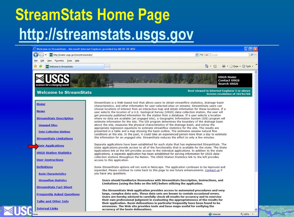
4 StreamStats Home Page
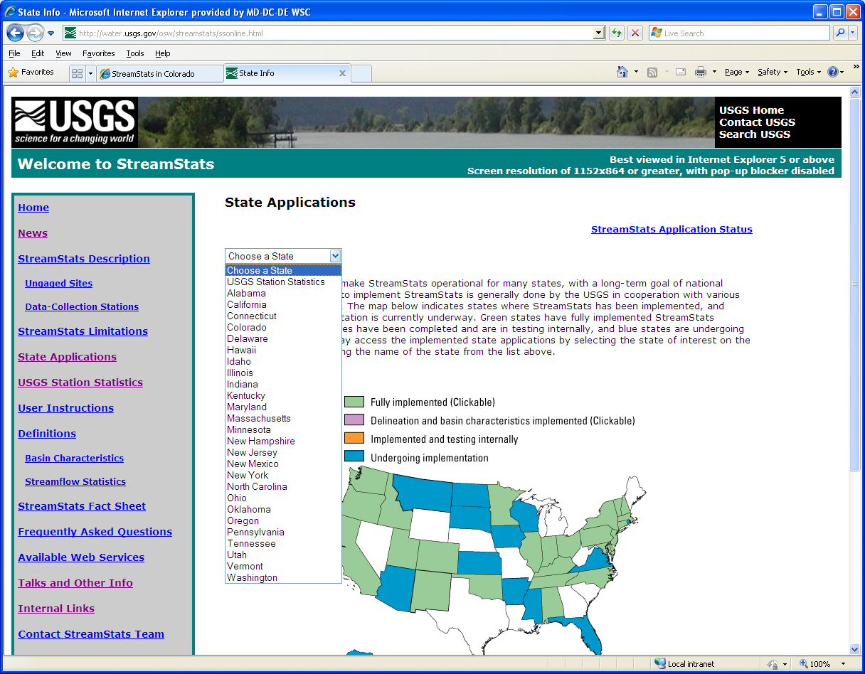
5 State Applications


6 Kentucky Introductory Page Description of statistics estimated Report citation with hyperlink Limitations Link to application

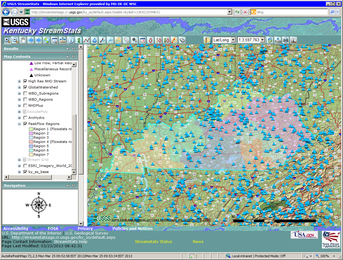
7 Kentucky User Interface Panel Banners Toolbar Console

8 Working With Panels Click on plus triangle (+) sign to to expand expand panel list


9 Display Streamgages Check box beside layer name (Stream Gages)


10 Navigation Panel Click on points of compass to move map center

11 Overview Map


12 Results Panel / Identify Tool


13 Streamgage Information

14 StreamStatsDB Database MS Access database that contains information for streamgages and regression equations used in StreamStats. Gage data from national databases now. WSCs provide updates as part of local studies For Kentucky, StreamStatsDB will be updated to include streamgage information from: SIR , Low-Flow Frequencies WRIR , Mean-Annual Streamflows WRIR , Harmonic-Mean Streamflows


15 Display of Layers

16 Hydrologic Regions

17 Select Ungaged Site Click on Watershed Delineation from a Point Scale must indicate 1:24,000 or greater

18 Delineated Basin

19 StreamStats Integrates NHD, WBD and NED in ArcHydro National Hydrography Dataset (NHD) Watershed Boundary Dataset (WBD) National Elevation Dataset (NED)
 National Elevation")


20 Flow Statistics from Regression Equations Regression equation Click Estimate Flows estimates assume Using Regression natural Equations flow conditions at the selected site Availability of equations varies among states

21 Example Regression Equation Regression equations take the form: Q 100 = A S 0.14 P 1.35 where: Q 100 is the 100-year flood flow, cubic feet per second A S P is drainage area, in square miles is mean basin slope, in percent is a mean annual precipitation, in inches This equation is for the Colorado Mountain Region
22 Adding Regression Equations Low flow -- SIR Q 2, 7Q 10, 7Q 20, 30Q 2, 30Q 5, Prob. zero flow ~ A, V Mean-annual flow -- WRIR Q a ~ A, E, Lat Harmonic-mean flow -- WRIR Q h ~ A, V
23 Regression Equation Limitations Low flows:sir Errors/applicable range
24 Other Tools for Use With Delineated Basins Edit a Delineated Basin Add or remove areas Get Basin Characteristics Computes additional BCs Edit Parameters and Recompute Flows Allows testing of scenarios Download Shapefile Print maps Estimate Flows Based on Similar Streamgaging Stations Estimates flows using nearby streamgages and drainage-area ratio method Relies on stream network navigation

25 Network Navigation/NHD Reach Indexing Explanation Measure User-selected site Streamgaging station Dam site Point discharge Water withdrawal Biological sampling site StreamStats provides reach addresses for user-selected sites, consisting of reach number and percentage distance from downstream end of reach


26 Flow Estimation Based on Similar Gages Click on Estimate Flows See Ries, Based 2006, on USGS Similar Estimates provided if Techniques Streamgaging and Methods Stations RATIO >= 0.5 and <= 1.5 Book 4-A6, p 9 for weighting equations
27 Network Tracing in StreamStats Configure trace Specify layer used (NHD, NHDPlus, etc.) Direction of tracing (upstream, downstream, both) Participating event layers (gages, dams, etc.) Load event layer Trace from delineated or ad-hoc point Display identified reaches Identify point events Raindrop trace to network Display path from point to network, and downstream Compute reach address at point on network
28 Network Tracing in StreamStats
29 Network Tracing in StreamStats
30 Network Tracing in StreamStats

31 Network Profile Plots Trace flow path within a delineated watershed Show network path and profile Show main channel flow path and profile


32 Terrain Profile Tool
33 Batch Processing Input: a point shapefile snapped to the stream grid Uses Web Services to perform the computations s the user when the output is available

34 StreamStats Web Services Available for: Basin delineation Gaging station statistics Ungaged site statistics Compute NHD reach and measure More coming See Available Web Services link from StreamStats home page for more information
35 Enhanced / future capabilities Detailed water-use /water-budget modeling Estimating daily mean streamflows

36 Maryland Water-Use Summaries Available to all users Net = Σ Discharges Σ Withdrawals

37 Detailed Water-Use Site Information Available only for users with login privileges (mostly gov t agencies)
38 Estimating daily mean streamflow: QPPQ method Connecticut River UnImpacted Streamflow Estimation (CRUISE) tool Pennsylvania Baseline Streamflow Estimator (BaSE)
39 Estimating daily mean streamflow: QPPQ method Connecticut River UnImpacted Streamflow Estimation (CRUISE) tool Pennsylvania Baseline Streamflow Estimator (BaSE)
40 Proposed Further Kentucky Studies Estimating regulated low-flow statistics Validate water-use (withdrawal/discharge data) Update/regionalize harmonic-mean flow, flow durations, and other selected low-flow statistics (30Q10, 1Q10, 90Q10, and 4B3) Update statewide rural and urban peak flows
41 Planned StreamStats Enhancements Migration from ArcGIS Server 9.2 to 10, with web services for all functionality A single user interface for seamless access to all state and regional applications Automated annual update of non-interpretive streamflow statistics Enhanced descriptive information and indicators of errors of computed statistics for streamgages Estimation of daily flows for Connecticut R. and Delaware R. Basins, NY, PA, probably others Improved and expanded tracking of water use Improved documentation
42 Questions or Suggestions? URL StreamStats national team GS-W Kentucky project
43 Overview Description / Development / Current status Accessing the user interface Basic features and functionalities General guidelines for use Adding statistics and estimating equations for Kentucky StreamStats Enhanced / future StreamStats capabilities Proposed further studies in Kentucky
44 New User Interface
45 Application Selection Displays all regional and state applications near the point that was clicked
 Load event layer Trace from delineated or ad-hoc point Display identified reaches Identify point events Raindrop trace to network Display path from point to network, and downstream Compute reach")
46 Network Tracing in StreamStats Configure trace Specify layer used (NHD, NHDPlus, etc.) Direction of tracing (upstream, downstream, both) Participating event layers (gages, dams, etc.) Load event layer Trace from delineated or ad-hoc point Display identified reaches Identify point events Raindrop trace to network Display path from point to network, and downstream Compute reach address at point on network

47 National Implementation Status Fully Implemented Delineation and basin characteristics only Undergoing Implementation Not participating 28 states fully implemented 1 state partly implemented 10 states in implementation process
TENNESSEE GAS PIPELINE COMPANY, L.L.C.
 TENNESSEE GAS PIPELINE COMPANY, L.L.C. HYDROLOGIC & HYDRAULIC CALCULATIONS FOR WATERBODIES CROSSED BY CONNECTICUT PIPELINE EXPANSION PROJECT CONNECTICUT LOOP Submitted by: Tennessee Gas Pipeline Company,
A HYDROLOGIC NETWORK SUPPORTING SPATIALLY REFERENCED REGRESSION MODELING IN THE CHESAPEAKE BAY WATERSHED
 A HYDROLOGIC NETWORK SUPPORTING SPATIALLY REFERENCED REGRESSION MODELING IN THE CHESAPEAKE BAY WATERSHED JOHN W. BRAKEBILL 1* AND STEPHEN D. PRESTON 2 1 U.S. Geological Survey, Baltimore, MD, USA; 2 U.S.
A Flood Warning System for City of Findlay, Ohio
 A Flood Warning System for City of Findlay, Ohio Matt Whitehead US Geological Survey, Ohio Water Science Center 6480 Doubletree Avenue Columbus, Ohio 43229 Abstract The U.S. Geological Survey (USGS) and
Development of an Impervious-Surface Database for the Little Blackwater River Watershed, Dorchester County, Maryland
 Development of an Impervious-Surface Database for the Little Blackwater River Watershed, Dorchester County, Maryland By Lesley E. Milheim, John W. Jones, and Roger A. Barlow Open-File Report 2007 1308
Chapter 4. Flood Risk Assessment
 Chapter 4 Flood Risk Assessment Chapter Overview Any floodplain management program must be established on a sound technical and scientific basis in order to be effective, whether for flood loss reduction
SWAMP DATA MANAGEMENT PLAN
 SWAMP DATA MANAGEMENT PLAN Station Template Surface Water Ambient Monitoring Program August 27, 2013 TABLE OF CONTENTS C. Data Entry...3 D. Field Data Entry...3 1. PROGRAMS NEEDED FOR SWAMP DATA ENTRY
Hydrologic Modeling using HEC-HMS
 Hydrologic Modeling using HEC-HMS Prepared by Venkatesh Merwade School of Civil Engineering, Purdue University [email protected] April 2012 Introduction The intent of this exercise is to introduce you
Impact of water harvesting dam on the Wadi s morphology using digital elevation model Study case: Wadi Al-kanger, Sudan
 Impact of water harvesting dam on the Wadi s morphology using digital elevation model Study case: Wadi Al-kanger, Sudan H. S. M. Hilmi 1, M.Y. Mohamed 2, E. S. Ganawa 3 1 Faculty of agriculture, Alzaiem
Lecture 4: Streamflow and Stream Gauging
 Lecture 4: Streamflow and Stream Gauging Key Questions 1. What is stream discharge and what controls its magnitude? 2. What is a hydrograph? 3. Where is the velocity highest in a stream? 4. Where is the
Quality Assurance Reviews of Hydraulic Models Developed for the Central Valley Floodplain Evaluation and Delineation Program
 Quality Assurance Reviews of Hydraulic Models Developed for the Central Valley Floodplain Evaluation and Delineation Program Techniques Applied and Lessons Learned Seth Ahrens, P.E., CFM Selena Forman,
Watershed Modeling System
 Watershed Modeling System WMS v8.0 MARICOPA COUNTY TUTORIALS TABLE OF CONTENTS 1 MARICOPA COUNTY: NFF AND HEC-1... 1-1 1.1 OBJECTIVES... 1-1 1.2 DELINEATING THE WATERSHED... 1-1 1.3 BUILDING THE NFF SIMULATION...
ROSE CREEK WATERSHED HYDROLOGIC, HYDRAULIC, SEDIMENT TRANSPORT, AND GEOMORPHIC ANALYSES TASK 1 EXISTING DATA AND INFORMATION SUMMARY REPORT BACKGROUND
 ROSE CREEK WATERSHED HYDROLOGIC, HYDRAULIC, SEDIMENT TRANSPORT, AND GEOMORPHIC ANALYSES TASK 1 EXISTING DATA AND INFORMATION SUMMARY REPORT BACKGROUND The Rose Creek Watershed (RCW) consists of three planning
REGIONALIZATION OF HARMONIC-MEAN STREAMFLOWS IN KENTUCKY
 REGIONALIZATION OF HARMONIC-MEAN STREAMFLOWS IN KENTUCKY By Gary R Martin and Kevin J Ruhl US GEOLOGICAL SURVEY Water-Resources Investigations Report 92-4173 Prepared in cooperation with the KENTUCKY NATURAL
Development of Technical Data For Long Term Flood Solutions For the Red River Basin
 IDENTIFYING WHAT WE DIDN T KNOW Development of Technical Data For Long Term Flood Solutions For the Red River Basin LTFS Study Area U.S. Portion of Red River Basin (MN, ND & SD) Main Stem Red River Tributaries
Flash Flood Science. Chapter 2. What Is in This Chapter? Flash Flood Processes
 Chapter 2 Flash Flood Science A flash flood is generally defined as a rapid onset flood of short duration with a relatively high peak discharge (World Meteorological Organization). The American Meteorological
Stream Channel Cross Sections for a Reach of the Boise River in Ada County, Idaho
 U.S. Department of the Interior U.S. Geological Survey In cooperation with Federal Emergency Management Agency, City of Boise, City of Garden City, City of Eagle, and Ada County Stream Channel Cross Sections
Integrated Information Management System, Development of Web Interface, a.k.a. Online Data Portal (ODP)
") Integrated Information Management System, Development of Web Interface, a.k.a. Online Data Portal (ODP) USBR Science and Technology Project ID 3625 Eric Peterson, May 2014. Duration: Fiscal Year 2010 through
Integrated Information Management System, Development of Web Interface, a.k.a. Online Data Portal (ODP) USBR Science and Technology Project ID 3625 Eric Peterson, May 2014. Duration: Fiscal Year 2010 through
CSDMS TauDEM Clinic "Hands On" Exercise
 CSDMS TauDEM Clinic "Hands On" Exercise David Tarboton, [email protected] Utah State University Goal Be able to use TauDEM tools to derive hydrologically useful information from Digital Elevation Models (DEMs)
2.0 BASIC CONCEPTS OF OPEN CHANNEL FLOW MEASUREMENT
 2.0 BASIC CONCEPTS OF OPEN CHANNEL FLOW MEASUREMENT Open channel flow is defined as flow in any channel where the liquid flows with a free surface. Open channel flow is not under pressure; gravity is the
CHECKLIST FOR FILING AN APPLICATION FOR A GROUND AND/OR SURFACE WATER WITHDRAWAL PROJECT IN THE DELAWARE RIVER BASIN
 CHECKLIST FOR FILING AN APPLICATION FOR A GROUND AND/OR SURFACE WATER WITHDRAWAL PROJECT IN THE DELAWARE RIVER BASIN PLEASE COMPLETE CHECKLIST AND ENCLOSE WITH THE APPLICATION. If you need assistance,
Catchment Scale Processes and River Restoration. Dr Jenny Mant [email protected]. The River Restoration Centre therrc.co.uk
 Catchment Scale Processes and River Restoration Dr Jenny Mant [email protected] The River Restoration Centre therrc.co.uk 3 Main Catchment Elements Hydrology Energy associated with the flow of water affects
Real Time Flood Alert System (RTFAS) for Puerto Rico
 for Puerto Rico") Prepared in cooperation with the Puerto Rico Emergency Management Agency (PREMA) Real Time Flood Alert System (RTFAS) for Puerto Rico Overview The Real Time Flood Alert System is a web-based computer program,
Prepared in cooperation with the Puerto Rico Emergency Management Agency (PREMA) Real Time Flood Alert System (RTFAS) for Puerto Rico Overview The Real Time Flood Alert System is a web-based computer program,
A Method Using ArcMap to Create a Hydrologically conditioned Digital Elevation Model
 A Method Using ArcMap to Create a Hydrologically conditioned Digital Elevation Model High resolution topography derived from LiDAR data is becoming more readily available. This new data source of topography
Innovative Approaches in Flood Damage Reduction
 Innovative Approaches in Flood Damage Reduction Solutions for the Stormwater Management High Level Results 3D geospatial model of storm water management pond (GRCA, 2013) Enhanced understanding of storm
Introduction to ArcMap for Water Resources Data
 Introduction to ArcMap for Water Resources Data Barbara Parmenter and Jack Melcher, revised: 9/15/2011 INTRODUCTION... 1 CHOOSING A HCDN STATION FOR WATERSHED MAPPING... 2 DOWNLOADING DATA FROM THE NATIONAL
STATE OF MICHIGAN DEPARTMENT OF NATURAL RESOURCES. Michigan s Water Withdrawal Assessment Process and Internet Screening Tool
 DNR DEPARTMENT OF NATURAL RESOURCES MICHIGAN STATE OF MICHIGAN DEPARTMENT OF NATURAL RESOURCES SR55 May 2011 Michigan s Water Withdrawal Assessment Process and Internet Screening Tool David A. Hamilton
Guidance for Flood Risk Analysis and Mapping. Changes Since Last FIRM
 Guidance for Flood Risk Analysis and Mapping Changes Since Last FIRM May 2014 This guidance document supports effective and efficient implementation of flood risk analysis and mapping standards codified
CRS 610 Ventura County Flood Warning System Website
 CRS 610 Ventura County Flood Warning System Website Purpose This document gives instructions and a description of the information available via the Ventura County Watershed Protection District s (VCWPD)
Create a folder on your network drive called DEM. This is where data for the first part of this lesson will be stored.
 In this lesson you will create a Digital Elevation Model (DEM). A DEM is a gridded array of elevations. In its raw form it is an ASCII, or text, file. First, you will interpolate elevations on a topographic
Introduction to Raster Graphics and Applications
 Data Visualization Workshop May 7, 2015 Introduction to Raster Graphics and Applications Richard Koehler, PhD, PH NOAA, Boulder, CO [email protected] Source: usgs.gov Source: nrcs.gov Source: noaa.gov
Studying Topography, Orographic Rainfall, and Ecosystems (STORE)
") Studying Topography, Orographic Rainfall, and Ecosystems (STORE) Introduction Basic Lesson 2: Using ArcGIS Explorer to Analyze the Connection between Topography and Rainfall This lesson introduces Geographical
Studying Topography, Orographic Rainfall, and Ecosystems (STORE) Introduction Basic Lesson 2: Using ArcGIS Explorer to Analyze the Connection between Topography and Rainfall This lesson introduces Geographical
Remote Sensing, GPS and GIS Technique to Produce a Bathymetric Map
 Remote Sensing, GPS and GIS Technique to Produce a Bathymetric Map Mark Schnur EES 5053 Remote Sensing Fall 2007 University of Texas at San Antonio, Department of Earth and Environmental Science, San Antonio,
Environmental Data Management Programs
 Hydrologic Engineering Centre (HEC) Software CD Collection of programs, developed by the U.S. Army Corps of Engineers Environmental Data Management Programs Name: HEC-DSS Package Purpose: Data Storage
Stormwater Management in Chicago waterways :Basement Flooding and its prevention Kyungmin Kim
 Stormwater Management in Chicago waterways :Basement Flooding and its prevention Kyungmin Kim CE 394K GIS in Water Resources - David R. Maidment. Dec 4th 2015 Motivation and Objective Recently, Chicago
Appendix C - Risk Assessment: Technical Details. Appendix C - Risk Assessment: Technical Details
 Appendix C - Risk Assessment: Technical Details Page C1 C1 Surface Water Modelling 1. Introduction 1.1 BACKGROUND URS Scott Wilson has constructed 13 TUFLOW hydraulic models across the London Boroughs
Watershed Delineation
 ooooo Appendix D: Watershed Delineation Department of Environmental Protection Stream Survey Manual 113 Appendix D: Watershed Delineation Imagine a watershed as an enormous bowl. As water falls onto the
Image source: www.rivers.gov. Visual Data Analytics, LLC
 AWRA Spring Specialty AWRA Conference Spring Specialty on GIS Conference and Water on Resources GIS and Water VIII Resources May 13, 2014 Using a Temporal Information System for Visualization and Analysis
5.14 Floodplains and Drainage/Hydrology
 I-70 East Final EIS 5.14 Floodplains and Drainage/Hydrology 5.14 Floodplains and Drainage/Hydrology This section discusses floodplain and drainage/hydrology resources and explains why they are important
CHICKASAW COUNTY, MISSISSIPPI, AND INCORPORATED AREAS
 CHICKASAW COUNTY, MISSISSIPPI, AND INCORPORATED AREAS Chickasaw County Community Name Community Number CHICKASAW COUNTY 280269 (UNINCORPORATED AREAS) HOUSTON, CITY OF 280030 NEW HOULKA, TOWN OF 280067
National Dam Safety Program Technical Seminar #22. When is Flood Inundation Mapping Not Applicable for Forecasting
 National Dam Safety Program Technical Seminar #22 Thursday February 19 th 2015 Emmittsburg, MD When is Flood Inundation Mapping Not Applicable for Forecasting Victor Hom Hydrologic Services Division National
Estimating Potential Reduction Flood Benefits of Restored Wetlands
 Estimating Potential Reduction Flood Benefits of Restored Wetlands Kenneth W. Potter University of Wisconsin Introduction Throughout the summer of 1993 a recurring question was the impact of wetland drainage
Training session for the. Firm Yield Estimator. Version 1.0. Prepared for the Massachusetts Department of Environmental Protection
 Training session for the Firm Yield Estimator Version 1.0 Prepared for the Massachusetts Department of Environmental Protection June 6, 2000 Firm Yield Estimator - Introduction Software tool for estimating
Methods for Determination of Safe Yield and Compensation Water from Storage Reservoirs
 US Army Corps of Engineers Hydrologic Engineering Center Methods for Determination of Safe Yield and Compensation Water from Storage Reservoirs October 1966 Approved for Public Release. Distribution Unlimited.
Travel Time. Computation of travel time and time of concentration. Factors affecting time of concentration. Surface roughness
 3 Chapter 3 of Concentration and Travel Time Time of Concentration and Travel Time Travel time ( T t ) is the time it takes water to travel from one location to another in a watershed. T t is a component
Fort Dodge Stormwater Master Planning. Prepared By: Ralph C. Stark, Jr., P.E., C.F.M. Joel N. Krause, P.E., C.F.M.
 Fort Dodge Stormwater Master Planning Prepared By: Ralph C. Stark, Jr., P.E., C.F.M. Joel N. Krause, P.E., C.F.M. Project Location Project Background Flooding History Localized flooding and storm sewer
Hydrologic Engineering Techniques for Regional Water Resources Planning
 US Army Corps of Engineers Hydrologic Engineering Center Hydrologic Engineering Techniques for Regional Water Resources Planning October 1969 Approved for Public Release. Distribution Unlimited. TP-17
CHAPTER 3 STORM DRAINAGE SYSTEMS
 CHAPTER 3 STORM DRAINAGE SYSTEMS 3.7 Storm Drains 3.7.1 Introduction After the tentative locations of inlets, drain pipes, and outfalls with tail-waters have been determined and the inlets sized, the next
United States Department of the Interior U.S. GEOLOGICAL SURVEY Reston, Virginia 20192
 United States Department of the Interior U.S. GEOLOGICAL SURVEY Reston, Virginia 20192 In Reply Refer To: March 6, 2015 Mail Stop 415 OFFICE OF SURFACE WATER TECHNICAL MEMORANDUM 2015.05 SUBJECT: Minimum
The Mississippi River & Tributaries Project
 The Mississippi River & Tributaries Project The Mississippi River & Tributaries (MR&T) project was authorized by the 1928 Flood Control Act. Following the devastating 1927 flood, the nation was galvanized
Earth Data Science in The Era of Big Data and Compute
 Earth Data Science in The Era of Big Data and Compute E. Lynn Usery U.S. Geological Survey [email protected] http://cegis.usgs.gov U.S. Department of the Interior U.S. Geological Survey Board on Earth Sciences
Shooks Run Drainage Study Basic Terminology
 Shooks Run Drainage Study Basic Terminology PREPARED FOR: PREPARED BY: City of Colorado Springs CH2M DATE: April 9, 2015 Introduction This document is intended to provide an introduction to Colorado Springs
Challenges. Estimated Damages from 100-Year Flood
 Suffield Suffield is a rural community located along the Massachusetts border. It encompasses about 42.2 square miles and has a population of about 15,735. Suffield s terrain rises from an elevation of
LR 314 Working Group 5 Final Report
 LR 314 Working Group 5 Final Report I. Nebraska Department of Natural Resources Table 1. NDNR and NATURAL RESOURCES COMMISSION WATER/INTEGRATED MANAGEMENT PLANNING RELATED RESEARCH, STUDIES AND RELATED
URBAN DRAINAGE CRITERIA
 URBAN DRAINAGE CRITERIA I. Introduction This division contains guidelines for drainage system design and establishes a policy for recognized and established engineering design of storm drain facilities
AZ EGER-PATAK HIDROLÓGIAI VIZSGÁLATA, A FELSZÍNI VÍZKÉSZLETEK VÁRHATÓ VÁLTOZÁSÁBÓL ADÓDÓ MÓDOSULÁSOK AZ ÉGHAJLATVÁLTOZÁS HATÁSÁRA
 AZ EGER-PATAK HIDROLÓGIAI VIZSGÁLATA, A FELSZÍNI VÍZKÉSZLETEK VÁRHATÓ VÁLTOZÁSÁBÓL ADÓDÓ MÓDOSULÁSOK AZ ÉGHAJLATVÁLTOZÁS HATÁSÁRA GÁBOR KEVE 1, GÉZA HAJNAL 2, KATALIN BENE 3, PÉTER TORMA 4 EXTRAPOLATING
UNION COUNTY, FLORIDA AND INCORPORATED AREAS
 UNION COUNTY, FLORIDA AND INCORPORATED AREAS COMMUNITY NAME COMMUNITY NUMBER LAKE BUTLER, CITY OF 120595 RAIFORD, TOWN OF 120593 UNION COUNTY 120422 (UNINCORPORATED AREAS) WORTHINGTON SPRINGS, CITY OF
Facilitating Adaptive Management in the Chesapeake Bay Watershed through the Use of Online Decision Support Tools
 Facilitating Adaptive Management in the Chesapeake Bay Watershed through the Use of Online Decision Support Tools Cassandra Mullinix, Scott Phillips, Kelly Shenk, Paul Hearn, Olivia Devereux Abstract The
The Rational Method. David B. Thompson Civil Engineering Deptartment Texas Tech University. Draft: 20 September 2006
 The David B. Thompson Civil Engineering Deptartment Texas Tech University Draft: 20 September 2006 1. Introduction For hydraulic designs on very small watersheds, a complete hydrograph of runoff is not
FLOODPLAIN DELINEATION IN MUGLA-DALAMAN PLAIN USING GIS BASED RIVER ANALYSIS SYSTEM
 FLOODPLAIN DELINEATION IN MUGLA-DALAMAN PLAIN USING GIS BASED RIVER ANALYSIS SYSTEM Dr. Murat Ali HATİPOĞLU Fatih KESKİN Kemal SEYREK State Hydraulics Works (DSI), Investigation and Planning Department
HYDROLOGIC/HYDRAULIC MODELING OF WESTMINSTER WATERSHED ORANGE COUNTY, CALIFORNIA
 HYDROLOGIC/HYDRAULIC MODELING OF WESTMINSTER WATERSHED ORANGE COUNTY, CALIFORNIA James Chieh, Ph.D., P.E., Senior Hydraulic Engineer, USACE, Los Angeles, California, [email protected]; Jay Pak,
Risk Analysis, GIS and Arc Schematics: California Delta Levees
 Page 1 of 7 Author: David T. Hansen Risk Analysis, GIS and Arc Schematics: California Delta Levees Presented by David T. Hansen at the ESRI User Conference, 2008, San Diego California, August 6, 2008 Abstract
Reservoir Simulations for the Delaware River Basin Flood of June, 2006
 Reservoir Simulations for the Delaware River Basin Flood of June, 2006 Middle Atlantic River Forecast Center State College, PA August 2007 (Revised 9/13/07) Introduction: In the late spring of 2005, the
ArcGIS Reference Document
 Migration of GIS Data to ArcSDE Page 1 of 10 Table of Contents A Brief Summary of DEP s GIS Data Storage o The Y Drive o ArcSDE (Spatial Database) Keeping Your GIS Project Data Current o Checking Your
How To Hydrologically Condition A Digital Dam
 Program: Funding: Conservation Applications of LiDAR Data http://tsp.umn.edu/lidar Environment and Natural Resources Trust Fund Module: Instructor: Hydrologic Applications Sean Vaughn, DNR GIS Hydrologist
State-Federal Flood Operations Center Informational Sheet
 State of California The Resources Agency DEPARTMENT OF WATER RESOURCES DIVISION OF FLOOD MANAGEMENT State-Federal Flood Operations Center Informational Sheet November 2014 Flood Operations Branch Overview
The Delaware Valley Early Warning System Kelly Anderson, Philadelphia Water
 The Delaware Valley Early Warning System Kelly Anderson, Philadelphia Water 2015 Exchange Network National Meeting Supporting the Business of Environmental Protection September 29 October 1, 2015 Sheraton
Procedures for No-Rise Certification For Proposed Developments in the Regulatory Floodway
 US Department of Homeland Security Region X 130 228 th Street, SW Bothell, WA 98021 Procedures for No-Rise Certification For Proposed Developments in the Regulatory Floodway Section 60.3 (d) (3) of the
Converting GIS Datasets into CAD Format
 Ball State University Libraries GIS Research and Map Collection Converting GIS Datasets into CAD Format Author: Angela Gibson, 6/13/2014 Overview: One of the most common requests from students is for GIS
RECOGNIZING THE VALUE OF WATER QUALITY MONITORING
 CHAPTER 15: CREATING A NATIONAL WATER QUALITY MONITORING NETWORK Ongoing monitoring is essential to assess the health of ocean and coastal ecosystems and detect changes over time. More than any other measure,
https://orm.usace.army.mil/orm2/f?p=106:34:4198546103662037::no::
 Page 1 of 6 APPROVED JURISDICTIONAL DETERMINATION FORM U.S. Army Corps of Engineers JD Status: DRAFT SECTION I: BACKGROUND INFORMATION A. REPORT COMPLETION DATE FOR APPROVED JURISDICTIONAL DETERMINATION
HCP Team Meeting. November 18, 2015. icfi.com
 HCP Team Meeting November 18, 2015 icfi.com 1 Welcome and Introductions Where are we in the HCP process Hydrology modeling update Native fish survey Fish translocation Finalize covered activities Next
A. Flood Management in Nevada
 Nevada Division of Water Planning A. Flood Management in Nevada Introduction Flooding has been a concern for Nevada communities since the first settlers moved to the territory in the mid-1800 s. Fourteen
Lower Raritan Watershed Management Area Stormwater & Flooding Subcommittee Strategy Worksheet LRSW-S3C1
 Strategy Name: Reduce Existing Potential for Flood Damages LRSW-S3C1. Develop and implement a program to: Minimize flood damages through the use of structural measures. Minimize flood damages through the
Adoption of an Interim 602(a) Storage Guideline. Final Environmental Assessment
 Storage Guideline. Final Environmental Assessment") Adoption of an Interim 602(a) Storage Guideline Final Environmental Assessment U.S. Department of the Interior Bureau of Reclamation March 2004 The mission of the Department of the Interior is to protect
Adoption of an Interim 602(a) Storage Guideline Final Environmental Assessment U.S. Department of the Interior Bureau of Reclamation March 2004 The mission of the Department of the Interior is to protect
SIMULATION OF SEDIMENT TRANSPORT AND CHANNEL MORPHOLOGY CHANGE IN LARGE RIVER SYSTEMS. Stephen H. Scott 1 and Yafei Jia 2
 US-CHINA WORKSHOP ON ADVANCED COMPUTATIONAL MODELLING IN HYDROSCIENCE & ENGINEERING September 19-21, Oxford, Mississippi, USA SIMULATION OF SEDIMENT TRANSPORT AND CHANNEL MORPHOLOGY CHANGE IN LARGE RIVER
 Using the Spatial Database Engine to develop a FEMA friendly Database and Asset Management Tool José Maria Guzmán, PE February 2009 GAFM 4th Annual Technical Conference Columbus, GA Outline Typical Datasets
STATISTICAL SOFTWARE PACKAGE
 STATISTICAL SOFTWARE PACKAGE Jeff Harris [email protected], Gary [email protected], Matt Fleming [email protected], Beth Faber Ph.D. [email protected],
DANIELS RUN STREAM RESTORATION, FAIRFAX, VIRGINIA: FLOODPLAIN ANALYSIS REPORT
 DANIELS RUN STREAM RESTORATION, FAIRFAX, VIRGINIA: FLOODPLAIN ANALYSIS REPORT By: Conor C. Shea Stream Habitat Assessment and Restoration Program U.S. Fish and Wildlife Service CBFO-S07-01 Prepared in
PRECIPITATION AND EVAPORATION
 PRECIPITATION AND EVAPORATION OBJECTIVES Use historical data to analyze relationships between precipitation, evaporation and stream flow in the San Antonio River Basin TOPICS Water cycle Precipitation
Evaluation of Open Channel Flow Equations. Introduction :
 Evaluation of Open Channel Flow Equations Introduction : Most common hydraulic equations for open channels relate the section averaged mean velocity (V) to hydraulic radius (R) and hydraulic gradient (S).
Land Disturbance, Erosion Control and Stormwater Management Checklist. Walworth County Land Conservation Department
 Land Disturbance, Erosion Control and Stormwater Management Checklist Walworth County Land Conservation Department The following checklist is designed to assist the applicant in complying with the Walworth
Floods of April 28, 1966 In the Northern Part of Dallas, Texas
 Floods of April 28, 1966 In the Northern Part of Dallas, Texas GEOLOGICAL SURVEY WATER-SUPPLY PAPER 1870-B Prepared in cooperation with the city of Dallas Floods of April 28, 1966 In the Northern Part
CHAPTER 2 HYDRAULICS OF SEWERS
 CHAPTER 2 HYDRAULICS OF SEWERS SANITARY SEWERS The hydraulic design procedure for sewers requires: 1. Determination of Sewer System Type 2. Determination of Design Flow 3. Selection of Pipe Size 4. Determination
Whitebox Geospatial Analysis Tools Tutorial Series. Tutorial 3: Streams and Watershed Extraction
 1 Whitebox Geospatial Analysis Tools Tutorial Series Tutorial 3: Streams and Watershed Extraction 2 Tutorial version 1.0, March, 2010 Written by John Lindsay, Whitebox Geospatial Analysis Tools Project
Michigan Tech Research Institute Wetland Mitigation Site Suitability Tool
 Michigan Tech Research Institute Wetland Mitigation Site Suitability Tool Michigan Tech Research Institute s (MTRI) Wetland Mitigation Site Suitability Tool (WMSST) integrates data layers for eight biophysical