KENTUCKY TRANSPORTATION CENTER
|
|
|
- Brittney Singleton
- 9 years ago
- Views:
Transcription
1 Research Report KTC-11-19/SPR F KENTUCKY TRANSPORTATION CENTER GUIDELINES FOR ROAD DIET CONVERSIONS

2 OUR MISSION We provide services to the transportation community through research, technology transfer and education. We create and participate in partnerships to promote safe and effective transportation systems. OUR VALUES Teamwork Listening and communicating along with courtesy and respect for others. Honesty and Ethical Behavior Delivering the highest quality products and services. Continuous Improvement In all that we do.

3 R GUIDELINES FOR ROAD DIET CONVERSIONS Draft Final Report

4 1. Report Number KTC-11-XX / SPR F 2. Government Accession No. 3. Recipient s Catalog No. 4. Title and Subtitle Guidelines for Road Diet Conversions 5. Report Date November Performing Organization Code 7. Author(s) N. Stamatiadis, A. Kirk, C. Wang, and A. Cull 9. Performing Organization Name and Address Kentucky Transportation Center College of Engineering University of Kentucky Lexington, Kentucky Sponsoring Agency Name and Address Kentucky Transportation Cabinet 200 Mero Street Frankfort, KY 8. Performing Organization Report No. KTC-11-XX / SPR F 10. Work Unit No. 11. Contract or Grant No. SPR Type of Report and Period Covered: Final Report; 07/10 12/11 Fi l 14. Sponsoring Agency Code 15. Supplementary Notes 16. Abstract 17. Key Words Intersection Design, Roundabout, Inside left-turn, median u-turn, superstreet, continuous flow, jughandle, bowtie, intersection evaluation 18. Distribution Statement Unlimited 19. Security Classification (report) Security Classification (this page) 21. No. of Pg: Price $0

5 TABLE OF CONTENTS LIST OF FIGURES

6 LIST OF TABLES

7 TABLE OF CONTENTS LIST OF FIGURES

8 LIST OF TABLES

9 TABLE OF CONTENTS Error! Bookmark not defined. Error! Bookmark not defined. Error! Bookmark not defined. LIST OF FIGURES

10 LIST OF TABLES
11 EXECUTIVE SUMMARY

12

13 INTRODUCTION

14 LITERATURE REVIEW

15

16 METHODOLOGY
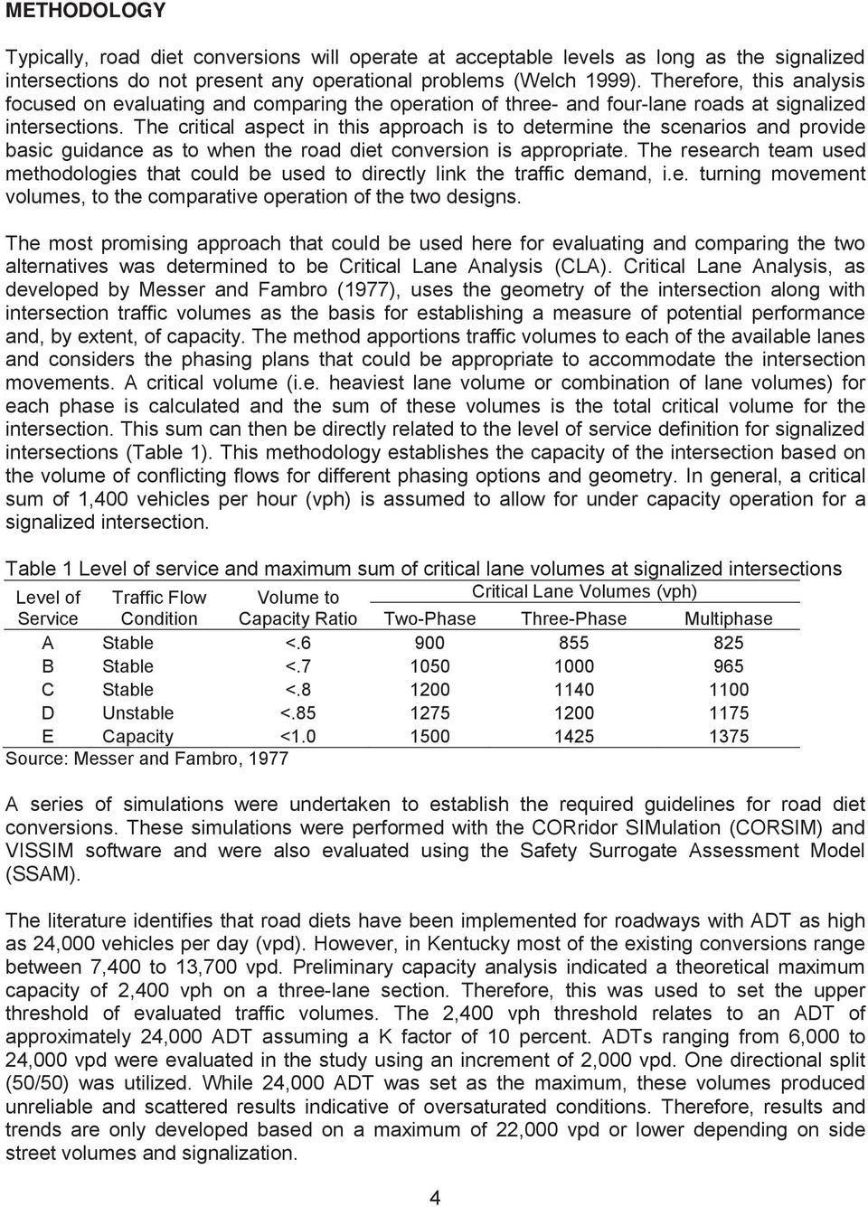
17

18

19 RESULTS Signalized Intersections negative lower

20
21 negative shorter
22
23 Unsignalized Intersections
24 negativelower
25 Operations Models
26
27 Signalized Intersection Safety
28
29
30
31 Unsignalized Intersection Safety
32
33 Safety Models
34
35 Summary
36
37 CASE STUDIES US 27 Campbell County Euclid Ave. Fayette County KY 1428 Floyd County US 172 Mercer County
38 US 60 Woodford County
39 Summary
40 GUIDELINES Road Diet Conversions
41 CONCLUSIONS AND SUMMARY
42
43 REFERENCES Road Diets: Fixing the Big Roads Evaluation of Lane Reduction Road Diet Measures and Their Effects of Crashes and Injuries Evaluation of Lane Reduction Road Diet Measures on Crashes Manual on Uniform Traffic Control Devices Paper No Transportation Research Record 2165 Surrogate Safety Assessment Model and Validation: Final Report, Transportation Research Record 1784 ) Guidelines for the Conversion of Urban Four-Lane Undivided Roadways to Three-Lane Two-Way Left-Turn Lane Facilities Final Report Transportation Research Record 644 Journal of the Transportation Research Board No Road Diet handbook: Setting Trends for Livable Communities Proceedings 3rd International Symposium on Highway Geometric Design
44 Highway Capacity Manual Transportation Research Board Urban Street Symposium
45 APPENDIX A
46 ROAD DIET CASE STUDY EVALUATION US 60 VERSAILLES, KY (FINAL) REPORT Prepared by Prepared for: Date:
47 TABLE OF CONTENTS LIST OF FIGURES LIST OF TABLES
48 INTRODUCTION Figure 1 Figure 1: Study Area
49 ROAD DIET IMPLEMENTATION Figure 2. Figure 2: Typical Sections Figure 3 Figure 4.
50 Figure 3: Road Diet Cross-Section Figure 4: US 60 with Standard Road Diet Figure 5.
51 Figure 5: US 60 with Added Shoulders Figure 6 Figure 7 Figure 6: US 60 with Parking
52 Figure 7: US 60 Road Diet Types and Locations
53 RESULTING CONDITIONS Travel Times Table 1 Table 1: Travel Time Study Crash History Table 2 Table 3 Table 2.
54 Table 2: Pre- Road Diet Three-Year Crash Summary ( ) Total Table 3: Post- Road Diet Three-Year Crash Summary ( ) Total
55 EVALUATION METHODOLOGY Safety Evaluation Operations Evaluation
56
57 EVALUATION SUMMARY Table 4 Table 4: Summary of Road Diet Installation Effects
58 ROAD DIET CASE STUDY EVALUATION EUCLID AVE. LEXINGTON, KY (FINAL) REPORT Prepared by Prepared for: Date:
59 TABLE OF CONTENTS LIST OF FIGURES LIST OF TABLES
60 INTRODUCTION Figure 1 Figure 1: Study Area
61 ROAD DIET IMPLEMENTATION Figure 2. Figure 2: Typical Section Figure 3
62 Figure 3: Road Diet Cross-Section Figure 4. Figure 4: Euclid Post-Road Diet Transformation
63 RESULTING CONDITIONS Travel Times Table 1 Table 1: Travel Time Study Crash History Table 2 Table 3 Table 2.
64 Table 2: Pre- Road Diet Three-Year Crash Summary ( ) Total Table 3: Post- Road Diet Three-Year Crash Summary ( ) Total
65 EVALUATION METHODOLOGY Safety Evaluation Operations Evaluation
66 EVALUATION SUMMARY Table 4 Table 4: Summary of Road Diet Installation Effects
67 ROAD DIET CASE STUDY EVALUATION US 27 CAMPBELL COUNTY, KY (FINAL) REPORT Prepared by Prepared for: Date:
68 TABLE OF CONTENTS LIST OF FIGURES LIST OF TABLES
69 INTRODUCTION Figure 1 Figure 1: Study Area
70 ROAD DIET IMPLEMENTATION Figure 2. Figure 2: Typical Section Figure3 Figure 3: Road Diet Cross-Section
71 Figures 4 5. Figure 4: US 27 Post-Road Diet Transformation (Near Ends with More Entrances) Figure 5: US 27 Post-Road Diet Transformation (In Middle with Few Entrances)
72 RESULTING CONDITIONS Travel Times Table 1 Table 1: Travel Time Study Crash History Table 2 Table 3 Table 2.
73 Table 2: Pre- Road Diet Three-Year Crash Summary ( ) Total Table 3: Post- Road Diet Three-Year Crash Summary ( ) Total
74 EVALUATION METHODOLOGY Safety Evaluation Operations Evaluation
75 EVALUATION SUMMARY Table 4 Table 4: Summary of Road Diet Installation Effects
76 ROAD DIET CASE STUDY EVALUATION KY 1428 FLOYD COUNTY, KY (FINAL) REPORT Prepared by Prepared for: Date:
77 TABLE OF CONTENTS LIST OF FIGURES LIST OF TABLES
78 INTRODUCTION Figure 1 Figure 1: Study Area
79 ROAD DIET IMPLEMENTATION Figure 2 and Figure 3. Figure 2: Initial Four Lane Section (North of KY 114) Figure 3: Initial Two Lane Section (South of KY 114)
80 Figure 4 Figure 5 Figure 4: Road Diet Cross-Section (North of 114) Figure 5: Road Diet Cross-Section (South of 114) Figures 6 Figure 7.
81 Figure 6: KY 1428 Post-Road Diet Transformation Figure 7: KY 1428 Post-Road Diet Transformation (Transition from Two Lanes)
82 RESULTING CONDITIONS Travel Times Table 1 Table 1: Travel Time Study Crash History Table 2 Table 3 Table 2.
83 Table 2: Pre- Road Diet Three-Year Crash Summary ( ) Total Table 3: Post- Road Diet Three-Year Crash Summary ( ) Total
84 EVALUATION METHODOLOGY Safety Evaluation Operations Evaluation
85 EVALUATION SUMMARY Table 4 Table 4: Summary of Road Diet Installation Effects
86 ROAD DIET CASE STUDY EVALUATION US 127 HARRODSBURG, KY (FINAL) REPORT Prepared by Prepared for: Date:
87 TABLE OF CONTENTS LIST OF FIGURES LIST OF TABLES
88 INTRODUCTION Figure 1 Figure 1: Study Area
89 ROAD DIET IMPLEMENTATION Figure 2. Figure 2: Typical Section Figure3 Figure 3: Road Diet Cross-Section
90 Figure 4. Figure 4: US 127 Post-Road Diet Transformation
91 RESULTING CONDITIONS Travel Times Table 1 Table 1: Travel Time Study Crash History Table 2 Table 3 Table 2.
92 Table 2: Pre- Road Diet Three-Year Crash Summary ( ) Total Table 3: Post- Road Diet Three-Year Crash Summary ( ) Total
93 EVALUATION METHODOLOGY Safety Evaluation Tables 2 3 Operations Evaluation
94 EVALUATION SUMMARY Table 4 Table 4: Summary of Road Diet Installation Effects
95 Prepared by Prepared for: ROAD DIET CASE STUDY EVALUATION KY 74 MIDDLESBORO, KY KYTC DISTRICT 11 FINAL REPORT Date:
96 TABLE OF CONTENTS LIST OF FIGURES LIST OF TABLES
97 INTRODUCTION Figure 1 Figure 1: Study Area
98 EXISTING CONDITIONS Figure 2 Figure 2: Typical Section Appendix A Traffic Volumes Appendix B Appendix B.
99 Travel Times Table 1 Table 1: Travel Time Study Westbound Total Eastbound Total Crash History Table 2
100 Table 2: Three-Year Crash Summary ( ) Total Appendix C
101 ROAD DIET ALTERNATIVE Figure 3 Figure 3: Typical Cross-Section
102 EVALUATION METHODOLOGY Calibration Table 3 Table 3: VISSIM Travel Time Calibration Westbound Total Eastbound Total
103 Measures of Effectiveness
104 RESULTS Operational Analysis Table 4 Table 4: Travel Time Corridor Level Travel Segment (KY 74) Travel Time(sec) AM Noon PM 4-Lane 3-Lane 4-Lane 3-Lane 4-Lane 3-Lane Westbound Total Eastbound Total Table 5
105 Table 5: PM Peak Hour Intersection Operations Summary Safety Analysis Table 6
106 Table 6: Safety Effects of Road Diet Total
107 DESIGN CONSIDERATIONS Figure 4
108
109 EVALUATION SUMMARY Table 7 Table 7: Summary of Road Diet Installation Effects
110
111 APPENDIX A Existing Conditions
112
113
114
115
116
117
118 APPENDIX B Traffic Volumes
119 , 2, 2 31, 9, 18 22nd 21st Street 20 th 33, 16, , 8, , CODE 934 STORE ITE CODE ING ITE CODE 210
120 FITZPATRICK , 39, 5 2, 1, , 26, 27 3, 3, th 18 th
121 , 7, 13 18, 9, th 0 4 4
122 , 19, 23 69, 24, 48 22nd 21st Street 20 th 29, 18, , 10, ,
123 19 th 18 th FITZPATRICK , 64, 4 9, 4, , 69, 69 2, 14,
124 15 th , 10, 34 31, 23,
125 22nd 21st Street 20 th , 11, , 34, 15 14, 10, , 30, 60 10,
126 19 th 18 th FITZPATRICK , 69, 12 6, 4, , 82, 81 10, 10,
127 15 th , 28, 45 56, 17,
128 APPENDIX C Crash Diagrams
129
130
131
132
133
134 APPENDIX B
135 INTRODUCTION ROAD DIET CONVERSIONS Process
136 Operational evaluation Safety evaluation
137 Operational Performance Safety Performance
138
139 Other Considerations
140 Design Considerations
141
142 Performance Evaluation When Not to Convert
143 Analysis Checklist Operational aspects Safety aspects Multimodal operations Access management Livability Operational consistency Transition design Cross section elements
144 REFERNCES Guidelines for Road Diet Conversions, 2.
145 For more information or a complete publication list, contact us at: KENTUCKY TRANSPORTATION CENTER 176 Raymond Building University of Kentucky Lexington, Kentucky (859) (859) (FAX) [email protected] The University of Kentucky is an Equal Opportunity Organization
Multi-Modal Corridor Degree of Complexity: High Cost/Benefit: High
 Multi-Modal Corridor Degree of Complexity: Cost/Benefit: Maintain the same level of service for Ensures continuous flow through the Might impact other transportation Consider road diet and/or different
Section 6 Traffic Analysis
 Section 6 Traffic Analysis Traffic Operations of the Preferred Network Alternative After the Preferred Network was identified and confirmed by local policy makers and area residents, detailed traffic analysis
KENTUCKY TRANSPORTATION CABINET. Department of Rural and Municipal Aid. Office of Local Programs
 KENTUCKY TRANSPORTATION CABINET Department of Rural and Municipal Aid Office of Local Programs Office of Local Programs Transportation Enhancements Safe Routes to School Congestion Mitigation and Air Quality
Roadway Cost Per Centerline Mile Revised June 2014
 Rural Arterial From LRE MOT * Mobilization * Subtotal Total PE Design (15%) CEI (15%) Total Project ** New (2-Lane Roadway) with 5' Paved Shoulders $3,351,896 $335,190 $368,709 $4,055,794 $1,013,949 $5,069,743
Kentucky Transportation Center
 Kentucky Transportation Center Research Report KTC -13-13/KSP2-11-1F Analysis of Traffic Crash Data in Kentucky (2008-2012) Our Mission We provide services to the transportation community through research,
Measuring the Street:
 Measuring the Street: New Metrics for 21st Century Streets 1 Measuring the Street: New Metrics for 21st Century Streets New York City s streets are constantly called on to the meet new and varied needs
CHAPTERTWO. Alternatives 2.1 ALTERNATIVES DEVELOPMENT PROCESS
 2. Section 2 TWO CHAPTERTWO 2.1 ALTERNATIVES DEVELOPMENT PROCESS This EIS has been prepared in compliance with the Council on Environmental Quality (CEQ) regulations for implementing NEPA (40 CFR 1500-1508).
The partnership has selected three intersections where enforcement, education, and engineering initiatives are being implemented to improve safety:
 Hamilton-Finn Suite 310 Tel. (403) 207-6000 Road Safety 3016 5th Avenue N.E. Fax. (403) 273-3440 Consultants Ltd. Calgary, Alberta dawatt.dawatt.com www.hamiltonfinn.ca January 19, 2005 Mr. Don Szarko,
Kentucky Transportation Center
 Kentucky Transportation Center Research Report KTC-12-13/KSP2-11-1F ANALYSIS OF TRAFFIC CRASH DATA IN KENTUCKY (2007-2011) Our Mission We provide services to the transportation community through research,
Comment #1: Provide an interchange at Route 7 and Farm Market Road/White Gate Road. This was studied in the late 1990 s.
 Proposed Truck Climbing Lane Route 7 Westbound Between West Market Street and Route 9 UPC# 58599, Project # 6007-053-133, P101 Date of Meeting: August 24, 2010 Time: 6:00PM to 8:00PM Location: Rust Library
Lawson Outline Plan External Traffic Analysis Working Paper
 Total Lawson Development ACTPLA 16 January 2009 Document No.: Prepared for ACTPLA Prepared by Maunsell Australia Pty Ltd Level 2, 60 Marcus Clarke Street, Canberra ACT 2600, Australia T +61 2 6201 3000
Road Signs Recognition Quiz
 Road Signs Recognition Quiz Place your answer for each of the signs/pavement markings on the answer sheet. Ready to Roll? Here Comes Sign # 1... #1 A No right turn B Right turn only C Warning, no turn
PROGRAM FOR ARTERIAL SYSTEM SYNCHRONIZATION (PASS) STANDARD SCOPE OF WORK, SCHEDULE AND BUDGET
 STANDARD SCOPE OF WORK, SCHEDULE AND BUDGET") PROGRAM FOR ARTERIAL SYSTEM SYNCHRONIZATION (PASS) STANDARD SCOPE OF WORK, SCHEDULE AND BUDGET The purpose of the Program for Arterial System Synchronization (PASS) is to provide technical and financial
PROGRAM FOR ARTERIAL SYSTEM SYNCHRONIZATION (PASS) STANDARD SCOPE OF WORK, SCHEDULE AND BUDGET The purpose of the Program for Arterial System Synchronization (PASS) is to provide technical and financial
Accident Analysis of Sheridan Road between Isabella Street and South Boulevard
 Accident Analysis of Sheridan Road between Isabella Street and South Boulevard Prepared for TranSystems Corporation for the City of Evanston Submitted by Regina Webster & Associates, Inc. Date: 08/15/2008
Median Bus Lane Design in Vancouver, BC: The #98 B-Line
 Li 1 Median Bus Lane Design in Vancouver, BC: The #98 B-Line Simon Li, P.Eng. PTOE Acting Program Manager, Road and Bridge Projects TransLink (Greater Vancouver Transportation Authority) 1600 4720 Kingsway
Intersection Cost Comparison Spreadsheet User Manual ROUNDABOUT GUIDANCE VIRGINIA DEPARTMENT OF TRANSPORTATION
 Intersection Cost Comparison Spreadsheet User Manual ROUNDABOUT GUIDANCE VIRGINIA DEPARTMENT OF TRANSPORTATION Version 2.5 i Virginia Department of Transportation Intersection Cost Comparison Spreadsheet
Chapter 6. Intersections. 6 Intersections
 Chapter 6 Intersections 6 Intersections Chapter 6 Intersection Design 6.1 Introduction An intersection is the area where two or more streets join or cross at-grade. The intersection includes the areas
I-25 / Rio Bravo Interchange
 I-25 / Rio Bravo Interchange TONIGHT S MEETING SCHEDULE OPEN HOUSE 6:00 PM TO 6:30 PM PRESENTATION BEGINS AT 6:30 PM Q & A FOLLOWING PRESENTATION CN A300280 / PNA300280 I-25 / Rio Bravo Interchange SECOND
APPENDIX F. Access Management Design Standards for Entrances and Intersections
 APPENDIX F Access Management Design Standards for Entrances and Intersections PREFACE The access management regulations and standards do not apply in cities, towns of more than 3,500 and in counties (Henrico
HIGHWAY DESIGN REPORT. Appendix 4. Proposed Design Principles for City Passings
 HIGHWAY DESIGN REPORT Appendix 4 Proposed Design Principles for City Passings June 2000 Contents Page 1 Introduction 2 1.1 Purpose 2 1.2 Definition of city passing 2 1.3 Safety Problems 2 1.4 Planning
DOT HS 809 360 October 2001
 U.S. Department of Transportation National Highway Traffic Safety Administration DOT HS 809 360 October 2001 Technical Report This document is available to the public from the National Technical Information
TRANSPORTATION IMPACT ANALYSIS PROCEDURES MANUAL
 TRANSPORTATION IMPACT ANALYSIS PROCEDURES MANUAL INTRODUCTION The Town of Harrisburg is committed to establishing an interconnected, multimodal transportation system that increases mobility, safety, connectivity,
APPENDIX J TRAFFIC STUDY
 APPENDIX J TRAFFIC STUDY May 7, 2014 Ms. Leianne Humble Denise Duffy and Associates, Inc. 947 Cass Street, Suite 5 Monterey, CA 93940 Re: Traffic Study for the Heritage Oaks Memorial Park in San Jose,
Massachusetts Department of Transportation, Highway Division Ten Park Plaza, Boston, MA 02116-3973. A Guide on Traffic Analysis Tools
 Massachusetts Department of Transportation, Highway Division Ten Park Plaza, Boston, MA 02116-3973 A Guide on Traffic Tools Revised October 5, 2012 1. PURPOSE The Massachusetts Department of Transportation,
Disputed Red Light Accidents: A Primer on Signal Control. Jon B. Landerville, MSME, PE Edward C. Fatzinger, MSME, PE Philip S.
 Disputed Red Light Accidents: A Primer on Signal Control Jon B. Landerville, MSME, PE Edward C. Fatzinger, MSME, PE Philip S. Wang, MSME Intersection Accident Statistics Intersection accidents occur on
Technical note. 1. Background. 2. Document Purpose. Project: A350 Chippenham Dualling
 Project: A350 Chippenham Dualling Subject: Benefits Realisation Plan & Monitoring and Evaluation Plan Date: 14 February 2013 1. Background Restrictions to the capacity of the A350 to the north of Chippenham
14-97. 14-97.002 Definitions. For the purposes of this rule chapter the following definitions shall apply unless the context clearly shows otherwise:
 14-97 14-97.001 Purpose. This rule chapter sets forth an access control classification system and access management standards to implement the State Highway System Access Management Act of 1988. The implementation
Protected Bicycle Lanes in NYC
 Protected Bicycle Lanes in NYC New York City Department of Transportation Polly Trottenberg, Commissioner September 2014 NEW YORK CITY DEPARTMENT OF TRANSPORTATION 1 Overview Since 2007, the New York City
Chapter 23. Multilane Highways. 23.1 Introduction. 23.2 Multilane Highways. 23.2.1 Highway Classification
 Chapter 23 Multilane Highways 23.1 Introduction Increasing traffic flow has forced engineers to increase the number of lanes of highways in order to provide good manoeuvring facilities to the users. The
North Avenue Corridor Study. Advisory Committee Meeting #5 June 11, 2014
 North Avenue Corridor Study Advisory Committee Meeting #5 June 11, 2014 Agenda Welcome and introductions Concept refinement and evaluation: Public meeting and web survey General cross-section concepts
TH 23 Access Management Study Richmond to Paynesville
 TH 23 Access Management Study Richmond to Paynesville Prepared For: Minnesota Department of Transportation District 8 Prepared By: Short Elliott Hendrickson Inc. July 2015 Table of Contents I. Introduction...
Accuracy of Pneumatic Road Tube Counters
 Accuracy of Pneumatic Road Tube Counters By: Patrick McGowen and Michael Sanderson Abstract: Pneumatic road tube counters are a tool that is commonly used to conduct traffic counts on streets and roads.
Doing a little can accomplish a lot. Proposed Change of Municipal Class Environmental Assessment from Schedule from B to A+
 Doing a little can accomplish a lot. Proposed Change of Municipal Class Environmental Assessment from Schedule from B to A+ Erin Mills Parkway Intersections at Dundas Street and Burnhamthorpe Road Index
Route Development Plan
 WSDOT Northwest Washington Division, Planning and Policy Office Route Development Plan State Route 99 North/Aurora Avenue North From the North end of the Battery Street Tunnel (Mile Post 32.44) to N. 145th
88.1 Traffic Signals at Roundabouts 213
 System Considerations 88.1 Traffic Signals at Roundabouts 213 8.1.1 Metered entrance 214 8.1.2 Nearby vehicular and pedestrian signals 214 8.1.3 Full signalization of the circulatory roadway 215 8.2 At-Grade
Temporary Traffic Control for Building and Maintaining Single and Multi-Lane Roundabouts
 Purpose and Background Temporary Traffic Control for Building and Maintaining Single and Multi-Lane Roundabouts Although roundabouts have recently gained popularity and use in the United States, minimal
TRANSPORTATION MODELLING IN CALGARY
 TRANSPORTATION MODELLING IN CALGARY Why Do We Use Transportation Models? There are three approaches that can be used for proceeding to develop a transportation system for Calgary s future. One approach
Chapter Forty-seven. RURAL TWO-LANE/MULTILANE STATE HIGHWAYS (New Construction/Reconstruction) BUREAU OF DESIGN AND ENVIRONMENT MANUAL
 BUREAU OF DESIGN AND ENVIRONMENT MANUAL") Chapter Forty-seven RURAL TWO-LANE/MULTILANE STATE HIGHWAYS (New Construction/Reconstruction) BUREAU OF DESIGN AND ENVIRONMENT MANUAL Illinois RURAL TWO-LANE/MULTILANE STATE HIGHWAYS December 2009 2 Illinois
Chapter Forty-seven RURAL TWO-LANE/MULTILANE STATE HIGHWAYS (New Construction/Reconstruction) BUREAU OF DESIGN AND ENVIRONMENT MANUAL Illinois RURAL TWO-LANE/MULTILANE STATE HIGHWAYS December 2009 2 Illinois
Mobility Management Plan Study of the Busch Boulevard Corridor
 Mobility Management Plan Study of the Busch Boulevard Corridor March 2000 Hillsborough County Metropolitan Planning Organization 601 E. Kennedy, 18th Floor Tampa, Florida 33602-5117 813/272-5940 FAX NO:
Maryland Invests $845 Million in New Highway and Bridge Projects
 Maryland Invests $845 Million in New Highway and Bridge Projects Completing Widening of MD 404 Talbot And Caroline Counties Top Regional Priority Queen Anne s, Talbot, and Caroline Counties Widening MD
Penalty points and fixed charge offences
 Appendix : points and fixed charge offences s that carry penalty points Payment Conviction 8 next 8 Speeding E0 Failure by Driver to comply with front seat belt requirements (for self and for passengers
Improving Access in Florida International University Biscayne Bay Campus Executive Summary
 EXECUTIVE SUMMARY Improving Access in Florida International University Biscayne Bay Campus Executive Summary Prepared for: Miami-Dade County Metropolitan Planning Organization (Miami-Dade MPO) Prepared
Downtown Louisville Two-Way Street Study
 Final Draft Report Downtown Louisville Two-Way Street Study Submitted to Downtown Development Corporation Submitted by ENTRAN, PLC Submitted October 2009 Table of Contents Introduction Study Purpose...1
Design and Implementation of Slot Left-Turn Lanes on the Manitoba Highway Network
 Design and Implementation of Slot Left-Turn Lanes on the Manitoba Highway Network Brent Hartmann, P. Eng., Project Design Engineer, Manitoba Infrastructure and Transportation Derek Durant, P. Eng., Senior
Tier 1 Strategies. WV Route 14 Corridor Management Plan
 1.1 1.2 1.3 1.4 Signal timing optimization system improvements. Improve geometry traffic control at high crash intersections. Construct intersection capacity improvement projects. Widen longer sections
Crash Analysis. Identify/Prioritize. Gather Data. Analyze Crashes and Identify Improvements. Review Funding Options. Implement Improvements
 Crash Analysis Identify/Prioritize 1. Find high crash areas 2. Review citizen input 3. Access City/County Safety Improvement Candidate Locations Gather Data 1. Use DOT-provided crash analysis programs
Rapid City Downtown Area Master Plan. Draft Plan Concepts April 2016
 Rapid City Downtown Area Master Plan Draft Plan Concepts April 2016 CALL TO ACTION! A Thriving Downtown = Regional Economic Prosperity Rapid City is competing nationally for a limited supply of young skilled
4.5 TRANSPORTATION - YEAR 2025 TRAFFIC CONDITIONS WITH PROPOSED TIMP 4.5-1 ESTIMATION OF TRIP REDUCTIONS WITH TIMP TRANSIT AND TDM PROGRAMS
 Draft Environmental Impact Report State Clearinghouse No. 2002061090 City of LA EIR No. 2003-1922-EIR CPC No. 98-0010 (CPU) 4.5 TRANSPORTATION - YEAR 2025 TRAFFIC CONDITIONS WITH PROPOSED TIMP This chapter
Minnesota State Patrol Fatal Crash Investigation May 23 rd, 2009 US Hwy 63 & MN Hwy 30
 Minnesota State Patrol Fatal Crash Investigation May 23 rd, 2009 US Hwy 63 & MN Hwy 30 Location Intersection of US 63 and MN 30 US 63 runs north and south, divided 4 lane road with grass median. MN 30
Principles of Road and Traffic Engineering Designs for Mixed Traffic Flow with a Numerous Motorcycles
 Principles of Road and Traffic Engineering Designs for Mixed Traffic Flow with a Numerous Motorcycles Dr. Ming-Heng Wang Assistant Professor, Department of Transportation Technology and Management, Kainan
ITS Deployment Analysis System (IDAS) Version 2.2, developed by Cambridge Systematics under contract to the Federal Highway Administration, 2002.
 Version 2.2, developed by Cambridge Systematics under contract to the Federal Highway Administration, 2002.") Chapter 8: BENEFITS ANALYSIS 8.1 INTRODUCTION Historically, benefits associated with ITS have been reported based on results of previous ITS deployments either within the particular region or around the
Chapter 8: BENEFITS ANALYSIS 8.1 INTRODUCTION Historically, benefits associated with ITS have been reported based on results of previous ITS deployments either within the particular region or around the
TRANSPORTATION SERVICE STANDARDS ELEMENT GOALS, OBJECTIVES & POLICIES
 TRANSPORTATION SERVICE STANDARDS ELEMENT GOALS, OBJECTIVES & POLICIES Background One of the most critical public services provided by a community is the community s transportation system. An effective
Kentucky Sign Management System
 Kentucky Sign Management System APRIL 2012 TRACY NOWACZYK TRANSPORTATION ENGINEER SPECIALIST OPERATIONS AND PAVEMENT MANAGEMENT KYTC Need Comply with MUTCD retroreflectivity standards Accurate, reliable
HIGHWAY DEPARTMENT ACCESS AND RIGHT OF WAY WIDTH GUIDELINES
 Approved 6/26/01 HIGHWAY DEPARTMENT ACCESS AND RIGHT OF WAY WIDTH GUIDELINES All new, modified and/or changed use access(es) onto county roads shall be subject to the access and corridor protection guidelines
KYTC, District 2 Chief District Engineer KYTC, District 2 Planning Supervisor & LPA Coordinator. KYTC, Central Office Planning
 MINUTES Field Visit for Local Officials and Stakeholders Bluegrass Crossings Regional Business Centre Improved Access Road Study Ritatsu Manufacturing (Board Room) Beaver Dam, Kentucky June 11, 2014 1:30
ENGINEERING REPORT. College Street: Interstate 85 to Donahue Drive Traffic Signal System Feasibility Study Auburn, Alabama
 ENGINEERING REPORT College Street: Interstate 85 to Donahue Drive Traffic Signal System Feasibility Study Auburn, Alabama Prepared for: The City of Auburn Prepared by: 3644 Vann Road Suite 100 Birmingham,
9988 REDWOOD AVENUE PROJECT TRAFFIC IMPACT ANALYSIS. April 24, 2015
 9988 REDWOOD AVENUE PROJECT TRAFFIC IMPACT ANALYSIS April 24, 2015 Kunzman Associates, Inc. 9988 REDWOOD AVENUE PROJECT TRAFFIC IMPACT ANALYSIS April 24, 2015 Prepared by: Bryan Crawford Carl Ballard,
BEFORE-AND-AFTER STUDY OF THE EFFECTIVENESS OF RECTANGULAR RAPID-FLASHING BEACONS USED WITH SCHOOL SIGN IN GARLAND, TEXAS
 BEFORE-AND-AFTER STUDY OF THE EFFECTIVENESS OF RECTANGULAR RAPID-FLASHING BEACONS USED WITH SCHOOL SIGN IN GARLAND, TEXAS Marcus A. Brewer (corresponding author) Associate Research Engineer Texas Transportation
Implementation Strategy
 Implementation Strategy 6 The following implementation strategy defines strategic points of intervention for complete streets programming, including visioning, goal-setting, local agency plans, coordination
ROUTE 178 CORRIDOR STUDY. Prepared For: KERN COG, CALTRANS, CITY OF BAKERSFIELD
 ROUTE 178 CORRIDOR STUDY Prepared For: KERN COG, CALTRANS, CITY OF BAKERSFIELD Prepared By: Barton-Aschman Associates, Inc. December 1986 TABLE OF CONTENTS 1. INTRODUCTION 1 Study Background 1 Study Purpose
Collection and Use of MAC Address Data for the Travel Demand Model
 Collection and Use of MAC Address Data for the Travel Demand Model Li Jin, Kittelson & Associates, Inc. (email: [email protected]) Matt Wiesenfeld, Kittelson & Associates, Inc. Karl Passetti, Kittelson
Development of a Traffic Management Center- Intelligent Transportation Systems Lab
 Development of a Traffic Management Center- Intelligent Transportation Systems Lab By Daniel S. Turner Professor of Civil Engineering and Director of UTCA Department of Civil and Environmental Engineering
SIGHT DISTANCE. Presented by Nazir Lalani P.E. Traffex Engineers Inc. [email protected] WHY IS SIGHT DISTANCE SO IMPORTANT?
 SIGHT DISTANCE Presented by Nazir Lalani P.E. Traffex Engineers Inc. [email protected] WHY IS SIGHT DISTANCE SO IMPORTANT? Drivers must be able to: Stop for objects in the roadway Stop for stationary
LIMITED SCOPE CONCEPT DEVELOPMENT REPORT
 LIMITED SCOPE CONCEPT DEVELOPMENT REPORT Route 33 Resurfacing Project Eastbound: Milepost 24.2 to Milepost 28.9 Westbound: Milepost 24.3 to Milepost 28.9 Manalapan & Freehold Townships, Monmouth County
SAN DIEGO - A BICYCLE FRIENDLY CITY
 SAN DIEGO - A BICYCLE FRIENDLY CITY MANY OPPORTUNITIES FOR IMPROVEMENT SUMMARY The designated bicycle paths and lanes in the City of San Diego (City) are often substandard because of their location and
ROAD SIGNS IN JAPAN PARKING SIGNS. No Parking or Stopping Anytime SIZE & WEIGHT LIMIT SIGNS SPEED LIMIT SIGNS
 ROAD SIGNS IN JAPAN Stop Slow & all Do Not Enter & Motorcycles Road Large Sized Trucks & Special Duty Road All Except Two Wheeled Light Except Bicycles Large Passenger No Right Turn No Passing No U-Turn
Major Improvement Schemes in Basingstoke
 Major Improvement Schemes in Basingstoke 1. Welcome Welcome to this exhibition, which provides information about the planned highway improvements being delivered in Basingstoke from 2015 2018. A30 Winchester
A Short Course on Techniques for Determining Construction Related Road User Costs
 TEXAS TRANSPORTATION INSTITUTE A Short Course on Techniques for Determining Construction Related Road User Costs prepared by TEXAS TRANSPORTATION INSTITUTE THE TEXAS A&M UNIVERSITY SYSTEM 701 NORTH POST
Florida Avenue Multimodal Transportation Study. June 19, 2013
 Florida Avenue Multimodal Transportation Study June 19, 2013 Today s Agenda Team & project introduction Project Timeline What you said Tools we use Mapped data and what clues it can provide Highlights
WORK ZONE SAFETY & MOBILITY GUIDANCE DOCUMENT
 WORK ZONE SAFETY & MOBILITY GUIDANCE DOCUMENT August 2007 Prepared by: Vermont Agency of Transportation The following document was drafted in response to updates made to the work zone regulations at 23