Intro to GIS Winter Geodatabases
|
|
|
- Bernard Oliver
- 9 years ago
- Views:
Transcription
1 Intro to GIS Winter 2011 Geodatabases

2 DATABASES

3 What is a Database? A database is an integrated set of data on a particular area and subject Databases form the basis of all GIS vector analysis and decision-making Databases must be structured and indexed to provide good query performance

4 Database Management Systems (DBMS) Relational (RDBMS) Object (ODBMS) Object Relational (ORDMS)
 Object")
5 Relational Database (RDBMS) A relational database comprises of a set of related tables tied together by a common attribute value Each table is a list of records containing attributes about objects

6 Object (ODBMS) & Object-Relational (ORDBMS) Designed to address the weaknesses of RDBMS such as Geometry and attribute data are stored in separate databases Poor performance for many types of geographic query ODBMS can provide object-oriented storage and query tools Geographic extensions to standard RDBMS can provide similar functionality

7
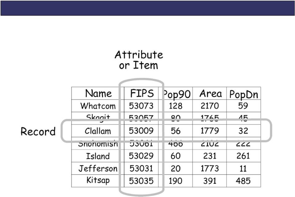
8 Data Structure record: a row in a geographic database; represents one feature (a.k.a. tuple, row ) attribute: a column in a geographic database; each attribute: a column in a geographic database; each record contains one attribute value (a.k.a. field, column )
 attribute: a column in a geographic database;")
9
10

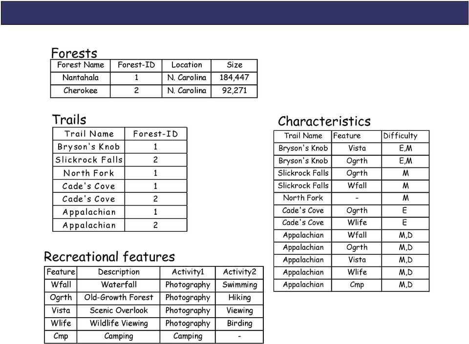
11 Principles of a RDBMS One value in each cell at the intersection of a row and a column All values in a column are about the same subject (and have the same type of number) Each row is unique Each column has a unique name (13 characters) There is no significance to the sequence of columns There is no significance to the sequence of rows

12 What is a Geographic Database? contain one or more tables with a geographic component (a shape attribute)

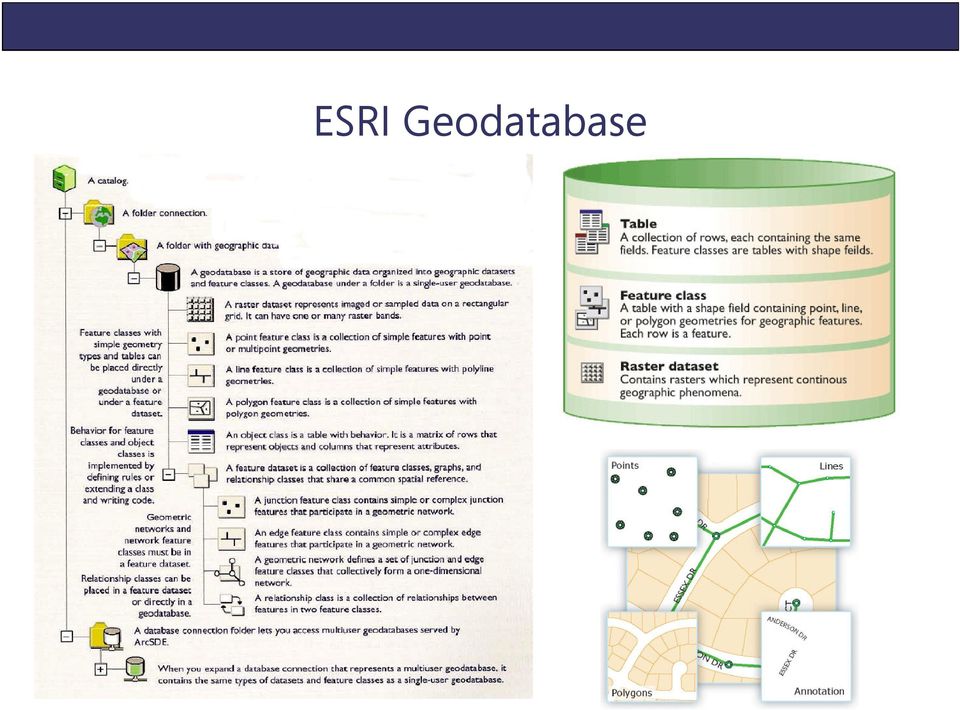
13 ESRI Geodatabase Features have: Shapes Spatial Reference Attribute Subtypes Features can be: Constrained (domains) Validated by Rules Complex behavior Relationships

14 ESRI Geodatabase
15 Types of Geodatabases Personal File Single-user Microsoft Access Up to 2GB storage Single-user ArcSDE Multi-User, supports versioning Oracle, Microsoft SQL Server, IBM DB2, IBM Informix, PostgreSQL Storage limit based on DB File folder structure Up to 1TB storage ESRI Comparison of Geodatabases

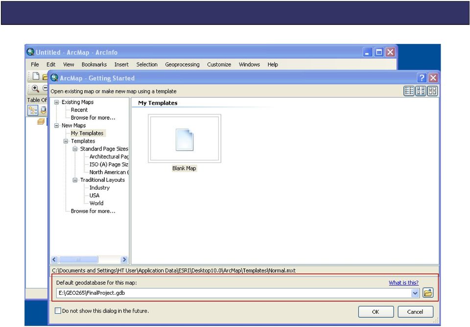
16 Default Geodatabase stores all datasets in one convenient location set a database for each project helps with data management add datasets and save resulting datasets


17


18
19 JOINING & RELATING TABLES

20 Joins & Relates Allows GIS user to map attributes that may not be present in the original table Join: appending the fields of one table to those of another through an attribute or field common to both tables Relate: an operation that establishes a temporary connection between records in two tables using a key common to both

21 Spatial Join: a type of table join operation in which fields from one layer's attribute table are appended to another layer's attribute table based on the relative locations of the features in the two layers
22 Joins & Relates when to use a join: relationship between tables is oneto-one, or many-to-one when to use a relate: relationship between tables is one-to-many
23 One-to-One Many-to-One
24 Joins & ArcGIS Non-spatial data can be added into ArcGIS in.dbf or.xls format Common fields must match exactly Example: Multnomah County and Multnomah County NOT: Multnomah County and Multnomah Joins are temporary To make permanent, export data to a new shapefile
25 Working in Excel No hidden spaces in the cells Column is formatted correctly - text if a text field, numerical if a number field, etc. No column (field) names are longer than 13 characters, have no spaces or symbols
26 DATABASE QUERIES
27 Attribute-Based Queries Selects records in a GIS database or table based on values of one or more attributes SQL: structured query language
28
29
30
31 Spatial Query Selects features based on location or spatial relationship with other GIS data (i.e., intersects, contains, within, etc.)
32
33
34
35 Joins, Relates & Queries ArcGIS Demo
Cookbook 23 September 2013 GIS Analysis Part 1 - A GIS is NOT a Map!
 Cookbook 23 September 2013 GIS Analysis Part 1 - A GIS is NOT a Map! Overview 1. A GIS is NOT a Map! 2. How does a GIS handle its data? Data Formats! GARP 0344 (Fall 2013) Page 1 Dr. Carsten Braun 1) A
Attribute Data and Relational Database. Lecture 5 9/21/2006
 Attribute Data and Relational Database Lecture 5 9/21/2006 definition Attribute data is about what of a spatial data and is a list or table of data arranged as rows and columns Rows are records (map features)
Geodatabase Programming with SQL
 DevSummit DC February 11, 2015 Washington, DC Geodatabase Programming with SQL Craig Gillgrass Assumptions Basic knowledge of SQL and relational databases Basic knowledge of the Geodatabase We ll hold
Basics on Geodatabases
 Basics on Geodatabases 1 GIS Data Management 2 File and Folder System A storage system which uses the default file and folder structure found in operating systems. Uses the non-db formats we mentioned
DATABASE MANAGEMENT FILES GIS06
 DATABASE MANAGEMENT Last day we looked at spatial data structures for both vector and raster data models. When working with large amounts of data, it is important to have good procedures for managing the
Spatial data models (types) Not taught yet
 Not taught yet") Spatial data models (types) Not taught yet A new data model in ArcGIS Geodatabase data model Use a relational database that stores geographic data A type of database in which the data is organized across
Spatial data models (types) Not taught yet A new data model in ArcGIS Geodatabase data model Use a relational database that stores geographic data A type of database in which the data is organized across
GIS Databases With focused on ArcSDE
 Linköpings universitet / IDA / Div. for human-centered systems GIS Databases With focused on ArcSDE Imad Abugessaisa [email protected] 20071004 1 GIS and SDBMS Geographical data is spatial data whose
Working with the Geodatabase Using SQL
 An ESRI Technical Paper February 2004 This technical paper is aimed primarily at GIS managers and data administrators who are responsible for the installation, design, and day-to-day management of a geodatabase.
Archival Challenges Associated with the Esri Personal Geodatabase and File Geodatabase Formats
 Geospatial Multistate Archive and Preservation Partnership (GeoMAPP) Archival Challenges Associated with the Esri Personal Geodatabase and File Geodatabase Formats December 6, 2011 Introduction Spatial
ArcGIS 10.1 Geodatabase Administration. Gordon Sumerling & Christopher Brown
 ArcGIS 10.1 Geodatabase Administration Gordon Sumerling & Christopher Brown Key Improvements at ArcGIS 10.1 1. Easier Administration through Graphic Interfaces 2. Greater Seamless integration with Open
Chapter 1: Introduction to ArcGIS Server
 Chapter 1: Introduction to ArcGIS Server At a high level you can think of ArcGIS Server as software that helps you take your geographic information and make it available to others. This data can be distributed
10. Creating and Maintaining Geographic Databases. Learning objectives. Keywords and concepts. Overview. Definitions
 10. Creating and Maintaining Geographic Databases Geographic Information Systems and Science SECOND EDITION Paul A. Longley, Michael F. Goodchild, David J. Maguire, David W. Rhind 005 John Wiley and Sons,
Spatial Database Support
 Page 1 of 11 Spatial Database Support Global Mapper can import vector data from and export vector data to the following spatial databases: Esri ArcSDE Geodatabase Esri File Geodatabase Esri Personal Geodatabases
Introduction to GIS. http://libguides.mit.edu/gis
 Introduction to GIS http://libguides.mit.edu/gis 1 Overview What is GIS? Types of Data and Projections What can I do with GIS? Data Sources and Formats Software Data Management Tips 2 What is GIS? 3 Characteristics
GEOGRAPHIC INFORMATION SYSTEMS Lecture 20: Adding and Creating Data
 Adding Existing Data Into ArcGIS - there are many different ways to get data into ArcGIS GEOGRAPHIC INFORMATION SYSTEMS Lecture 20: Adding and Creating Data Add Data - normally we use the Add Data button
ArcGIS Data Models Practical Templates for Implementing GIS Projects
 ArcGIS Data Models Practical Templates for Implementing GIS Projects GIS Database Design According to C.J. Date (1995), database design deals with the logical representation of data in a database. The
Terry Sherman Oklahoma South Central Arc-Users Group 2014 17 th Annual Conference 9/23/2014
 Terry Sherman Oklahoma South Central Arc-Users Group 2014 17 th Annual Conference 9/23/2014 About Terry Work: Research Cyberinfrastructure Analyst for OSU High Performance Computing Center developing research
Personal Geodatabase 101
 Personal Geodatabase 101 There are a variety of file formats that can be used within the ArcGIS software. Two file formats, the shape file and the personal geodatabase were designed to hold geographic
Government 1008: Introduction to Geographic Information Systems. LAB EXERCISE 4: Got Database?
 Government 1008: Introduction to Geographic Information Systems Objectives: Creating geodatabases Joining attribute tables Attribute and location based queries Spatial joins Creating spatial and attribute
 Advanced ArcSDE Administration for SQL Server Shannon Shields Tony Wakim Workshop Format Three topics What's New In-depth Database Administration Trouble-shooting / Performance Selection varies year to
Data Integration for ArcGIS Users Data Interoperability. Charmel Menzel, ESRI Don Murray, Safe Software
 Data Integration for ArcGIS Users Data Interoperability Charmel Menzel, ESRI Don Murray, Safe Software Product overview Extension to ArcGIS (optional) Jointly developed with Safe Software Based on Feature
White Paper. Freeance Mobile for Cityworks
 White Paper Freeance Mobile for Cityworks Version 1.1 May 2012 Freeance Mobile for Cityworks Freeance Mobile for Cityworks 2012.1 is a mobile application for the following smartphones and tablets: iphone
TIM 50 - Business Information Systems
 TIM 50 - Business Information Systems Lecture 15 UC Santa Cruz March 1, 2015 The Database Approach to Data Management Database: Collection of related files containing records on people, places, or things.
ESRI Technical Certification Overview. Amy Daniels Instructor, Greenville Tech
 ESRI Technical Certification Overview Amy Daniels Instructor, Greenville Tech Why have certification by ESRI? It communicates your proficiency in ESRI software Similar to Microsoft Certification, it can
Supported DBMS platforms DB2. Informix. Enterprise ArcSDE Technology. Oracle. GIS data. GIS clients DB2. SQL Server. Enterprise Geodatabase 9.
 ArcSDE Administration for PostgreSQL Ale Raza, Brijesh Shrivastav, Derek Law ESRI - Redlands UC2008 Technical Workshop 1 Outline Introduce ArcSDE technology for PostgreSQL Implementation PostgreSQL performance
Understanding ArcSDE. GIS by ESRI
 Understanding ArcSDE GIS by ESRI Copyright 1999 2004 ESRI All rights reserved. Printed in the United States of America. The information contained in this document is the exclusive property of ESRI. This
5.5 Copyright 2011 Pearson Education, Inc. publishing as Prentice Hall. Figure 5-2
 Class Announcements TIM 50 - Business Information Systems Lecture 15 Database Assignment 2 posted Due Tuesday 5/26 UC Santa Cruz May 19, 2015 Database: Collection of related files containing records on
Troubleshooting SQL Server Enterprise Geodatabase Performance Issues. Matthew Ziebarth and Ben Lin
 Troubleshooting SQL Server Enterprise Geodatabase Performance Issues Matthew Ziebarth and Ben Lin Troubleshooting SQL Server Enterprise Geodatabase Performance Issues AGENDA General configuration recommendations
Syllabus AGET 782. GIS for Agricultural and Natural Resources Management
 Syllabus AGET 782 Course Title: GIS for Agricultural and Natural Resources Management Course Abbreviation: AGET 782 Course Credits: Instructor: Course Description: Required Text: 3 hours Timothy N. Burcham,
GIS I Business Exr02 (av 9-10) - Expand Market Share (v3b, Jul 2013)
 - Expand Market Share (v3b, Jul 2013)") GIS I Business Exr02 (av 9-10) - Expand Market Share (v3b, Jul 2013) Learning Objectives: Reinforce information literacy skills Reinforce database manipulation / querying skills Reinforce joining and mapping
GIS I Business Exr02 (av 9-10) - Expand Market Share (v3b, Jul 2013) Learning Objectives: Reinforce information literacy skills Reinforce database manipulation / querying skills Reinforce joining and mapping
INTRODUCTION TO ARCGIS SOFTWARE
 INTRODUCTION TO ARCGIS SOFTWARE I. History of Software Development a. Developer ESRI - Environmental Systems Research Institute, Inc., in 1969 as a privately held consulting firm that specialized in landuse
GIS Architecture and Data Management Practices Boone County GIS Created and Maintained by the Boone County Planning Commission GIS Services Division
 GIS Architecture and Data Management Practices Boone County GIS Created and Maintained by the Boone County Planning Commission June 2008 Background Boone County s GIS program has been in existence for
Web Editing Tutorial. Copyright 1995-2010 Esri All rights reserved.
 Copyright 1995-2010 Esri All rights reserved. Table of Contents Tutorial: Creating a Web editing application........................ 3 Copyright 1995-2010 Esri. All rights reserved. 2 Tutorial: Creating
UNLEASHED. The Field Calculator. By Tom Neer, EDAW, Inc.
 The Field Calculator UNLEASHED By Tom Neer, EDAW, Inc. Understanding basic programming techniques allows the GIS user greater flexibility and expands the functionality of ArcGIS. Software developers no
Database Servers Tutorial
 Copyright 1995-2010 Esri All rights reserved. Table of Contents A quick tour of the database servers tutorial........................ 3 Exercise 1: Add a database server to the Catalog tree and create
GIS II: Data Management: Creation, edition and maintenance of geographic data Module 1: Leveraging the where of your geographic data
 *** Files needed for exercise: MT_ACS09_trt.shp, and McDonalds_rr.shp Goals: After completing this exercise, you will have experience in performing spatial joins and selections and reviewed your understanding
Working with Geodatabase Topology
 Developed and Presented by Juniper GIS 1/38 Course Objectives Understanding how Geodatabase Topology works Geodatabase Rules Creating Geodatabase Topology Editing with Geodatabase Topology Geometric Networks
University of Arkansas Libraries ArcGIS Desktop Tutorial. Section 4: Preparing Data for Analysis
 : Preparing Data for Analysis When a user acquires a particular data set of interest, it is rarely in the exact form that is needed during analysis. This tutorial describes how to change the data to make
Geodatabase Tuning and Performance. Gillian Silvertand Greg Cunningham
 Geodatabase Tuning and Performance Gillian Silvertand Greg Cunningham Introduction to the Multiuser Geodatabase Workshop outline Performance and scalability Description Design Configuration Tuning and
Geodatabase Tutorial. Copyright 1995-2010 Esri All rights reserved.
 Copyright 1995-2010 Esri All rights reserved. Table of Contents A quick tour of the Building a geodatabase tutorial..................... 3 Exercise 1: Organizing your data in the Catalog......................
Topology. Shapefile versus Coverage Views
 Topology Defined as the the science and mathematics of relationships used to validate the geometry of vector entities, and for operations such as network tracing and tests of polygon adjacency Longley
Data Modeling Basics. John Auel GIS Technician II United Services Group
 Data Modeling Basics John Auel GIS Technician II United Services Group Background Bachelor of Science at University of Wisconsin, Steven s Point Area of Emphasis -- Cartography Been at United Services
Converting GIS Datasets into CAD Format
 Ball State University Libraries GIS Research and Map Collection Converting GIS Datasets into CAD Format Author: Angela Gibson, 6/13/2014 Overview: One of the most common requests from students is for GIS
Bentley ArcGIS. Connector
 Bentley ArcGIS Connector Introduction ESRI, as a GIS software products company, and Bentley Systems, Incorporated, as a developer of solutions for architecture/engineering/construction (AEC) professionals,
ArcGIS. Server. A Complete and Integrated Server GIS
 ArcGIS Server A Complete and Integrated Server GIS ArcGIS Server A Complete and Integrated Server GIS ArcGIS Server enables you to distribute maps, models, and tools to others within your organization
RESPONSE TO GIS SERVICES RFP. 1. What version of ArcGIS software are you using? If it is not the latest, is there a plan to upgrade?
 RESPONSE TO GIS SERVICES RFP 1. What version of ArcGIS software are you using? If it is not the latest, is there a plan to upgrade? We are currently using ArcGIS 10.x as follows: ArcGIS for Desktop - Mixed
Analysing Big Data in ArcGIS
 OIL & GAS Analysing Big Data in ArcGIS AIS based risk modelling Esri European Petroleum GIS Conference 2014 Karl John Pedersen 7th November 2014 1 DNV GL 2014 7th November 2014 SAFER, SMARTER, GREENER
The Courses. Covering complete breadth of GIS technology from ESRI including ArcGIS, ArcGIS Server and ArcGIS Engine.
 ESRI India: Corporate profile ESRI India A profile India s Premier GIS Company Strategic alliance between ESRI Inc. and NIIT Technologies Adjudged as India s Best GIS Solutions Company - Map India 2001
(Geo)database and Data Management
database and Data Management") (Geo)database and Data Management An introduction to the possibilities of a centralized (spatial) data storing and access as well as its data management constraints (GLOWA Volta Project) GLOWA Volta Project
(Geo)database and Data Management An introduction to the possibilities of a centralized (spatial) data storing and access as well as its data management constraints (GLOWA Volta Project) GLOWA Volta Project
Tutorial 4 - Attribute data in ArcGIS
 Tutorial 4 - Attribute data in ArcGIS Note: Before beginning the tutorial, please make sure your server folder is mapped. The data you will be working with this week is contained in a winzip archive called
Database Systems. Lecture 1: Introduction
 Database Systems Lecture 1: Introduction General Information Professor: Leonid Libkin Contact: [email protected] Lectures: Tuesday, 11:10am 1 pm, AT LT4 Website: http://homepages.inf.ed.ac.uk/libkin/teach/dbs09/index.html
Enterprise GIS Solutions to GIS Data Dissemination
 Enterprise GIS Solutions to GIS Data Dissemination ESRI International User Conference July 13 17, 2009 Wendy M. Turner Senior GIS Engineer & Program Manager Freedom Consulting Group, LLC Building the Enterprise
MobileMap and Spatial Content Management: Integrating Field Data Collection, Document Management and Enterprise GIS for Natural Resources
 MobileMap and Spatial Content Management: Integrating Field Data Collection, Document Management and Enterprise GIS for Natural Resources BRIAN GRASS MASON, BRUCE & GIRARD The Mobile Revolution Proliferation
Abstract. Introduction
 Data Replication and Data Sharing Integrating Heterogeneous Spatial Databases Mark Stoakes and Katherine Irwin Professional Services, Safe Software Inc. Abstract Spatial data warehouses are becoming more
2 Working with a Desktop GeoDatabase
 2 Working with a Desktop GeoDatabase Introduction... 3 1 Installation of an ESRI Desktop GeoDatabase... 3 1.1 Installation of Microsoft SL Server Express instance... 5 1.2 Installation of the ArcSDE libraries
UPDATED GIS DATABASE DESIGN: Geodatabase Model
 CITY OF SUFFOLK, VIRGINIA UPDATED GIS DATABASE DESIGN: Geodatabase Model Prepared by: Michael Baker Jr., Inc. Virginia Beach, Virginia TABLE OF CONTENTS A. GEODATABASE OVERVIEW...2 B. TYPES OF GEODATABASES...3
Getting your app together with Web AppBuilder for ArcGIS
 Getting your app together with Web AppBuilder for ArcGIS Walter Simonazzi Walter Simonazzi Session path What is Web AppBuilder for ArcGIS? Web AppBuilder for ArcGIS tour What s new? July 2015 Demos Community
Pennsylvania Geospatial Data Sharing Standards (PGDSS) V 2.5
 V 2.5") Submitted to: Pennsylvania Geospatial Data Sharing Standards (PGDSS) V 2.5 Spatial Data Migration Tools Report May 2, 2007 Table of Contents 1.0 Document Purpose...B-1 2.0 Overview of Spatial Data Migration
Submitted to: Pennsylvania Geospatial Data Sharing Standards (PGDSS) V 2.5 Spatial Data Migration Tools Report May 2, 2007 Table of Contents 1.0 Document Purpose...B-1 2.0 Overview of Spatial Data Migration
Mississippi Private Schools 2015
 Mississippi Private Schools 2015 Shapefile Tags education, schools, private, K-12 Summary To add to state data clearinghouse the Mississippi private schools point features. Description Point locations
How to Download Census Data from American Factfinder and Display it in ArcMap
 How to Download Census Data from American Factfinder and Display it in ArcMap Factfinder provides census and ACS (American Community Survey) data that can be downloaded in a tabular format and joined with
Foundations of Business Intelligence: Databases and Information Management
 Chapter 5 Foundations of Business Intelligence: Databases and Information Management 5.1 Copyright 2011 Pearson Education, Inc. Student Learning Objectives How does a relational database organize data,
Databases and DBMS. What is a Database?
 Databases and DBMS Eric Lew (MSc, BSc) SeconSys Inc. Nov 2003 What is a Database? Data (singular: datum) Factual Information Database Organized body of related information Repository / storage of information
IBM Informix. Reference Documentation on Why Informix Spatial for GIS Projects
 IBM Informix Reference Documentation on Why Informix Spatial for GIS Projects Page 1 of 10 Contents Compliant with OGC... 3 Addressing the SQL standards... 3 Native Spatial, Intuitive Data Types... 3 Powerful
Database-driven web mapping using jquery, PHP, PostgreSQL & SDE
 Database-driven web mapping using jquery, PHP, PostgreSQL & SDE By, Jon Nordling, Michael Humber Inbal Becker-Reshef, Brian Barker, Katie McGaughey, Chris Justice University of Maryland College Park http://geoglam-crop-monitor.org/
Introduction to the ArcGIS Data Model and Application Structure
 Introduction to the ArcGIS Data Model and Application Structure RNR/GEOG 417/517 Lab 6 Presentation Overview The georelational data model Structure of ArcGIS software Structure of an ArcGIS workspace Demonstrations/previews
Enterprise GIS: Database Planning
 John Alsup Sr. Systems Engineer Jeff DeWeese Enterprise Solutions Architect Agenda Overview Database Design Data Maintenance Infrastructure Architecture Data Distribution Learn the key planning phases
Lecture 8. Online GIS
 Lecture 8 Online GIS Lecture 8: Outline I. Online GIS 1. Google Earth 2. MSN Live Maps II. Open Source GIS III. ArcGIS Server and the ESRI suite of online software utility options IV. Advanced Data Mining
Supported Platforms and Software Requirements Effective on 7 May.2014. HULFT-DataMagic for Windows Ver.2.2.0
 Supported Platforms and Software Requirements Effective on 7 May.2014 for Ver.2.2.0 for Ver.2 English Edition Code conversion option for English Edition Database connectivity option (DB2) for English Edition
The Relational Model. Why Study the Relational Model? Relational Database: Definitions. Chapter 3
 The Relational Model Chapter 3 Database Management Systems 3ed, R. Ramakrishnan and J. Gehrke 1 Why Study the Relational Model? Most widely used model. Vendors: IBM, Informix, Microsoft, Oracle, Sybase,
Relational Databases. Christopher Simpkins [email protected]
 Relational Databases Christopher Simpkins [email protected] Relational Databases A relational database is a collection of data stored in one or more tables A relational database management system
Step 2. Open ArcMap, set Projection to State Plane NAD 83 Feet Apply
 GIS III Exercise 01 Create a Database & Map Urban Land Use Jan 2010 Student Learning Outcomes: Import table data into an MS Access database; NOTE: DOS 8.3 naming is required for files being imported into
1. INTRODUCTION TO RDBMS
 Oracle For Beginners Page: 1 1. INTRODUCTION TO RDBMS What is DBMS? Data Models Relational database management system (RDBMS) Relational Algebra Structured query language (SQL) What Is DBMS? Data is one
GEOREFERENCING HISTORIC MAPS USING ARCGIS DESKTOP 10
 5/20/2011 BALL STATE UNIVERSITY LIBRARIES GIS RESEARCH AND MAP COLLECTION GEOREFERENCING HISTORIC MAPS USING ARCGIS DESKTOP 10 GEOREFERENCING HISTORIC MAPS USING ARCGIS DESKTOP 10 *This tutorial is appropriate
City of Tigard. GIS Data Standards
 City of Tigard GIS Data Standards City of Tigard 13125 SW Hall Blvd Tigard, Oregon 97223 503 639-4171 Page 1 of 5 1.0 Purpose The purpose of these standards is to provide guidance for geospatial data development
Working with SQL Profiler
 Working with SQL Profiler This tutorial complements the article Tracing ArcSDE Queries with SQL Profiler, by Shannon Shields and Joseph Buckles which appeared in the January March 2002 issue of ArcUser
Databases and Information Management
 Databases and Information Management Reading: Laudon & Laudon chapter 5 Additional Reading: Brien & Marakas chapter 3-4 COMP 5131 1 Outline Database Approach to Data Management Database Management Systems
Harvard Data Visualization Project
 Esri User Conference, July 12-15, San Diego California Harvard Data Visualization Project Spatio-Temporal Visualization of Global Phenomena: 1850 to the Present Harvard Business School Geoffrey Jones Walter
ArcGIS Tutorial: Adding Attribute Data
 ArcGIS Tutorial: Adding Attribute Data Introduction A common need in GIS is to map characteristics, or attributes, of different geographic areas. These maps are called thematic maps. Examples of thematic
2. Look for a link to ODESI data portal. In the Key Links section in the left side and double click ODESI Data Retrieval.
 Guide to convert census data from ODESI into GIS data ODESI, acronym for Ontario Data Documentation, Extraction Service and Infrastructure, is a web-based data exploration, extraction and analysis tool
Relational Database Basics Review
 Relational Database Basics Review IT 4153 Advanced Database J.G. Zheng Spring 2012 Overview Database approach Database system Relational model Database development 2 File Processing Approaches Based on
Choosing the right GIS framework for an informed Enterprise Web GIS Solution
 13 ANNUAL INTERNATIONAL CONFERENCE AND EXHIBITION ON GEOSPATIAL INFORMATION TECHNOLOGY AND APPLICATIONS Epicentre; Gurgaon, India; 19-21 January, 2010 Choosing the right GIS framework for an informed Enterprise
GeoManitoba Spatial Data Infrastructure Update. Presented by: Jim Aberdeen Shawn Cruise
 GeoManitoba Spatial Data Infrastructure Update Presented by: Jim Aberdeen Shawn Cruise Organization Overview Manitoba Innovation Energy and Mines Business Transformation and Technology (BTT) Application
An Esri White Paper February 2011 Best Practices for Storing the ArcGIS Data Reviewer Workspace in an Enterprise Geodatabase for Oracle
 An Esri White Paper February 2011 Best Practices for Storing the ArcGIS Data Reviewer Workspace in an Enterprise Geodatabase for Oracle Esri, 380 New York St., Redlands, CA 92373-8100 USA TEL 909-793-2853
INCOG Transportation Planning Division Spatial Data Management Workflow GIS-T 2008
 INCOG Transportation Planning Division Spatial Data Management Workflow GIS-T 2008 Kevin Tartar, GISP Transportation Geodatabase Coordinator 201 West 5th Street, Suite 600 Tulsa, Oklahoma 74103 Phone:
GIS III: GIS Analysis Module 2a: Introduction to Network Analyst
 *** Files needed for exercise: nc_cty.shp; target_stores_infousa.dbf; streets.sdc (provided by street map usa); NC_tracts_2000sf1.shp Goals: To learn how to use the Network analyst tools to perform network
Editing Strategies for Enterprise Geodatabase
 Federal GIS Conference February 9 10, 2015 Washington, DC Editing Strategies for Enterprise Geodatabase Ty Fabling Esri Solution Engineer A Complete Platform Enabling GIS Everywhere Desktop Web Device
Introduction to Using PostGIS Training Workbook Last Updated 18 June 2014
 Introduction to Using PostGIS Training Workbook Last Updated 18 June 2014 Prepared by: Simon Nitz, Senior Technical Consultant Digital Mapping Solutions NZ Limited 2nd Floor, 20 Bridge Street, Ahuriri,
The Relational Model. Why Study the Relational Model? Relational Database: Definitions
 The Relational Model Database Management Systems, R. Ramakrishnan and J. Gehrke 1 Why Study the Relational Model? Most widely used model. Vendors: IBM, Microsoft, Oracle, Sybase, etc. Legacy systems in
GEOL 452/552 - GIS for Geoscientists I. Lecture 9
 GEOL 452/552 - GIS for Geoscientists I Lecture 9 1 Review (voting) Joining tables (database joins) Tutorial ch 4: 27-33 (43-50) HW 5: ch 4, ex 1,2 (make new float field!), 4, 5, 8 & 10 Text 2 Find the
DATABASE MANAGEMENT SYSTEMS. Question Bank:
 DATABASE MANAGEMENT SYSTEMS Question Bank: UNIT 1 1. Define Database? 2. What is a DBMS? 3. What is the need for database systems? 4. Define tupule? 5. What are the responsibilities of DBA? 6. Define schema?
Administering Your Microsoft SQL Server Geodatabase
 Administering Your Microsoft SQL Server Geodatabase Shannon Shields Chet Dobbins Esri UC 2014 Technical Workshop Agenda News since the last UC How do I - Configure SQL Server to support geodatabases? -
Create and share a map with GIScloud.com
 Create and share a map with GIScloud.com GIS Cloud is a web based Geographic Information System powered by Cloud Computing and with the full power of desktop GIS. It allows users to create and access your
Package sjdbc. R topics documented: February 20, 2015
 Package sjdbc February 20, 2015 Version 1.5.0-71 Title JDBC Driver Interface Author TIBCO Software Inc. Maintainer Stephen Kaluzny Provides a database-independent JDBC interface. License
Guidelines on Information Deliverables for Research Projects in Grand Canyon National Park
 INTRODUCTION Science is playing an increasing role in guiding National Park Service (NPS) management activities. The NPS is charged with protecting and maintaining data and associated information that