Coordinated Hazard Assessment and Mapping Program
|
|
|
- Abraham Woods
- 7 years ago
- Views:
Transcription
1 Coordinated Hazard Assessment and Mapping Program


2
3 ASSESSING FLOOD HAZARDS IN ILLINOIS Floods are by far the most common natural disaster in Illinois, accounting for well over 90% of declared disasters. Flooding is also the most predictable natural hazard, yet Illinois citizens continue to suffer economic losses due to flooding. The first step to reduce economic and personal losses is to accurately identify where flooding is likely to occur. As a Federal Emergency Management Agency (FEMA) Cooperating Technical Partner (CTP), the Coordinated Hazard Assessment and Mapping Program (CHAMP) staff work with FEMA and the Illinois Department of Natural Resources, Office of Water Resources, to assess flood hazards and communicate flood risk. Between 2004 and 2013, CHAMP produced updated digital maps showing areas prone to flooding in 75 Illinois counties, and four additional countywide updates will be finalized by These Flood Insurance Rate Maps (FIRMs) show the areas nearly 12% of the state that have a 1% chance of inundation in any given year. Flooding potential requires continual reassessment, and FIRMs require continual updating with changing land use and climate and as better data become available. As of 2013, CHAMP has completed or has in progress updates for 14 counties in Illinois. Communities can use these maps to avoid putting citizens at risk by steering development away from high flood-risk areas and planning mitigation for built areas in identified floodplains. Engagement with community officials is ongoing throughout the study process and additional meetings are held to discuss proposed mapping updates and/or mitigation activities. The watershed data are updated for use by communities as projects progress.
 Cooperating Technical Partner (CTP), the Coordinated Hazard Assessment and Mapping Program (CHAMP) staff work with FEMA and the Illinois Department of")
4 STUDYING FLOOD HAZARDS The CHAMP team performs hydrologic and hydraulic studies to accurately determine flood hazards. These studies are conducted to meet state and federal standards for incorporation in the regulatory Flood Insurance Rate Maps. This work is performed for FEMA and under contract with communities or other agencies. The CHAMP team strives to provide the public with the most up-to-date flood hazard data on FEMA s FIRMs. CHAMP is committed to facilitating open communication with engineers, communities, and the public. A web page, Destined for DFIRMs, is maintained, showing the location of publicly funded studies (FEMA, state, local government). Engineers can consult this site to identify work in progress. illinoisfloodmaps.org/dfd.aspx

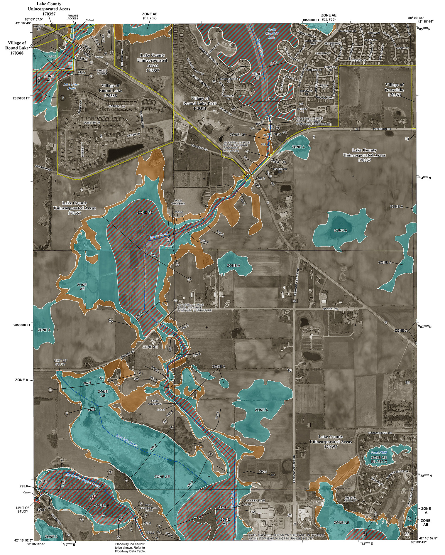
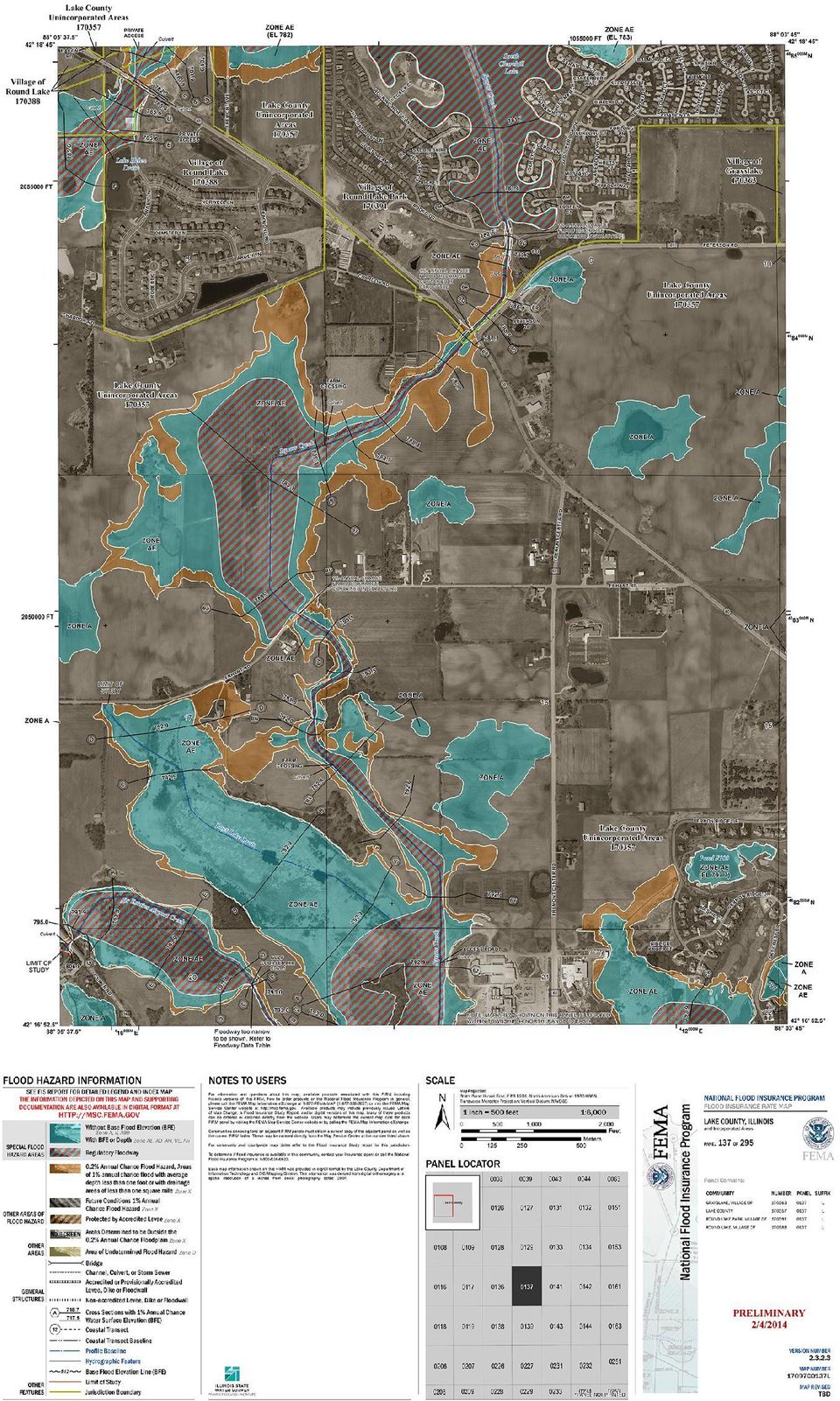
5 PROCESSING LOMR/CLOMR APPLICATIONS On September 1, 2010, the ISWS/CHAMP began reviewing applications for Letters of Map Revision (LOMR) and Conditional Letters of Map Revision (CLOMR) for non-levee revisions to the FIRMs as part of FEMAs LOMR Delegation Program. Currently, Illinois is one of only three statewide participants in the program. Through the LOMR Delegation Program, ISWS now has federal review authority of all non-levee MT-2 LOMR/CLOMR applications within the State of Illinois. Technical review of requests for map revisions by in-state staff provides a distinct advantage to engineers and developers in Illinois by offering consistent service from professionals ready to assist them throughout the process. Efficiencies in exchange of information about areas being studied are achieved through close coordination with program staff working on mapping studies and updates throughout Illinois all under one roof. H a n c o c k BOWEN «94 «61 AUGUSTA Williams Creek «101 This map illustrates stream reaches at risk for potential flooding that were not designated as Special Flood Hazard Areas (SFHAs) and were not shown on Federal Emergency Management Agency (FEMA) Flood Insurance Rate Maps as of July 1, Also shown are areas of Risk Class A (high), B (medium), and C (low) adopted by FEMA Region 5. Streams lacking a SFHA designation and draining more than one square mile in a Risk Class A area or draining more than 10 square miles in a Risk Class B or C area are shown with red lines. A table associated with this map lists streams with unmapped potential flood risk, their names, and the number of miles not within a Special Flood Hazard Area. µ Miles Legend Streams without SFHAs Streams Municipal Boundaries County Boundaries Interstate Hwy US Highways State Routes Roads Risk Classes A - High Risk B - Medium Risk White Creek Ursa Creek Rock Creek Little Creek LIMA «96 LORAINE URSA «61 MENDON « COLUMBUS Mill Creek Pigeon Creek H oney Creek Tourneal Creek «57 «96 «336 PAYSON PLAINVILLE Thurman Creek Crooke d Neck Creek 24 «336 «104 QUINCY «104 South Fork Bear Creek COATSBURG CAMP POINT North Branch McKee Creek McKee Creek LIBERTY «61 «94 LA PRAIRIE A d a m s Grindstone Creek CLAYTON Walnut Fork Fishhook Creek Cedar Creek Missouri Creek South Fork Cedar Creek S c h u y l e r Missouri Creek TIMEWELL Littl e M McK ee Cr eek B r o w n issouri Creek Missouri Creek Dry Fork Streams Classified by Risk: Adams County, Illinois C C - Low Risk P 36 i k e « Pigeon Creek nney Creek Beebe Creek BAYLIS IDENTIFYING UNMAPPED SPECIAL FLOOD HAZARD AREAS Some streams posing a flood hazard do not haved mapped floodplains. In order to communicate the risk of these areas, streams that have a potential flood risk for which Special Flood Hazard Areas (SFHAs) have not been mapped are identified for each Illinois county. CHAMP can conduct studies and prepare maps that meet FEMA standards for communities and counties that have unmapped SFHAs.

6 REACHING OUT TO COMMUNITIES Through collaboration with state, local, and tribal entities, FEMA s Risk Mapping Assessment and Planning (Risk MAP) program provides quality data that increase public awareness and promote action that reduces risk to life and property. The ultimate goal is to reduce flood losses and break the cycle of disasters. CHAMP staff are pursing the Risk MAP goals in Illinois. FEMA s plan calls for ongoing engagement with state and local officials and watershed stakeholders through a series of meetings. The process begins with Discovery at a watershed level called the HUC 8 (hydrologic unit code). Available data are collected across the watershed and then a Discovery Meeting is held to discuss flood issues and technical data needs with communities that lie all or partially within the watershed. Local officials, floodplain managers, community engineers and planners, local development interest, watershed groups, and other stakeholders attend the meetings, provide additional information, and discuss flood issues, technical data needs, and the status of mitigation planning in the watershed. Watershed reports, maps, and data are posted at illinoisfloodmaps.org/ discovery.aspx. Additional outreach meetings to discuss new studies (Flood Risk Review Meetings) and to discuss mitigation options (Resilience Meetings) are conducted by CHAMP to help communities understand, prepare for, and mitigate flood risk.
.")
7 APPLYING KNOWLEDGE OF FLOOD ISSUES TO RESEARCH CHAMP researchers apply the tools and knowledge acquired through preparing flood studies and working with communities to identify research needs. Research areas include trends in peak flows, impacts of urbanization, leveed areas, climate change impacts, and detailed hydrologic and hydraulic modeling. PRODUCING AND USING NON-REGULATORY DIGITAL PRODUCTS Detailed hydraulic studies have the potential to unlock a library of powerful digital mapping products. Using these models with high-resolution digital terrain models, digital depth grid data can be produced and used to display the depth of flooding for various frequency events (e.g. 10, 4, 2,1, and 0.2% frequency), the frequency of flooding at a given location in the floodplain, and/or the chance of inundation over a 30-year time period. When coupled with stream gage data and National Weather Service forecasts, the inundation areas for a given flood stage can be mapped. These data are shared with project stakeholders to make emergency management decisions and help mitigate flood risk. Another product being produced and delivered is a Changes Since Last Firm (CSLF) database. This database tracks the changes of Effective FIRM data and updated study information.

8 PREPARING NATURAL HAZARD MITIGATION PLANS A comprehensive Natural Hazard Mitigation Plan (NHMP) has proven to be an effective way to reduce or eliminate the risk to human life and property from natural hazards. Mitigation plans are the basis for FEMA funding for community projects that reduce exposure to flood losses. They provide valuable information and are enhanced when they include risk assessment determined by FEMA s HAZUS software, for which ISWS staff have specialized training. This powerful software couples current scientific and engineering knowledge with the latest Geographic Information Systems (GIS) technology to produce localized estimates of hazard-related damage and economic losses for buildings and infrastructure from earthquakes, hurricanes, and floods. Our HAZUS experts can prepare digital data, detailed maps, and reports of the potential impacts of natural hazards. The CHAMP team has worked with University of Illinois Extension providing Hazus data for mitigation planning in five counties. University of Illinois at Urbana-Champaign isws.illinois.edu Griffith Drive Champaign, IL Climate and Atmospheric Science: Chemistry and Technology: Groundwater Science: Water Quality: Surface Water Hydrology and Hydraulics: Coordinated Hazard Assessment and Mapping Program: Water Resources Data and Information: National Atmospheric Deposition Program:
 technology to produce localized estimates of hazard-related damage and")
Risk MAP Project Coordination Meeting: Burlington County, NJ. FEMA REGION II May 8, 2013 Westampton, New Jersey
 Risk MAP Project Coordination Meeting: Burlington County, NJ FEMA REGION II May 8, 2013 Westampton, New Jersey Agenda Introductions Purpose of this Meeting Risk MAP Program Overview Anticipated Project
Guidance for Flood Risk Analysis and Mapping. Changes Since Last FIRM
 Guidance for Flood Risk Analysis and Mapping Changes Since Last FIRM May 2014 This guidance document supports effective and efficient implementation of flood risk analysis and mapping standards codified
Why does Kittitas County want to form a Flood Control Zone District?
 KITTITAS COUNTY DEPARTMENT OF PUBLIC WORKS Kirk Holmes, Director What is a Flood Control Zone District (FCZD)? A Kittitas County Flood Control Zone District (FCZD) would be a special-purpose government
Community RiskMAP Questionnaire
 Community RiskMAP Questionnaire Please provide the following information County Date: Community Name/Organization: Your Your E-mail: Contact Preference: E-mail Phone Mail The Federal Emergency Management
5.14 Floodplains and Drainage/Hydrology
 I-70 East Final EIS 5.14 Floodplains and Drainage/Hydrology 5.14 Floodplains and Drainage/Hydrology This section discusses floodplain and drainage/hydrology resources and explains why they are important
Indiana Office of Community and Rural Affairs. Disaster Recovery and Mitigation Planning Ft. Worth, Texas February 15, 2012
 Indiana Office of Community and Rural Affairs Disaster Recovery and Mitigation Planning Ft. Worth, Texas February 15, 2012 Floods Indiana s costliest hazard State ranks 5 th in annual median flood damages
Oregon Pre-Disaster Mitigation Program Plan Update Training Manual
 FEMA Oregon Pre-Disaster Mitigation Program Plan Update Training Manual Prepared by: Oregon Partnership for Disaster Resilience OPDR FEMA OPDR FEMA OPDR 2010, University of Oregon s Community Service Center
Section 5 Floodplain Management Tools
 5.1 Floodprone Areas One of the major elements of the Master Plan is the updated 100-year floodplain and floodway boundary maps. This information provided the most up-to-date tools to protect homes and
The State of New Jersey. Fiscal Year 2004 Map Modernization Business Plan
 The State of New Jersey Fiscal Year 2004 Map Modernization Business Plan April 30, 2004 REGION II EXECUTIVE SUMMARY Introduction Historically, the State of New Jersey has taken a strong role in the development
FEMA s Risk Mapping, Assessment, and Planning (Risk MAP) Fiscal Year 2011 Report to Congress March 15, 2011. Federal Emergency Management Agency
 Fiscal Year 2011 Report to Congress March 15, 2011. Federal Emergency Management Agency") FEMA s Risk Mapping, Assessment, and Planning (Risk MAP) Fiscal Year 2011 Report to Congress March 15, 2011 Federal Emergency Management Agency Message from the Administrator March 15, 2011 I am pleased
FEMA s Risk Mapping, Assessment, and Planning (Risk MAP) Fiscal Year 2011 Report to Congress March 15, 2011 Federal Emergency Management Agency Message from the Administrator March 15, 2011 I am pleased
The AIR Inland Flood Model for the United States In Spring 2011, heavy rainfall and snowmelt produced massive flooding along the Mississippi River,
 The AIR Inland Flood Model for the United States In Spring 2011, heavy rainfall and snowmelt produced massive flooding along the Mississippi River, inundating huge swaths of land across seven states. As
DRAFT WATERSHED USA FLOOD RISK REPORT 1
 DRAFT WATERSHED USA FLOOD RISK REPORT 1 Preface The Department of Homeland Security (DHS), Federal Emergency Management Agency s (FEMA) Risk Mapping, Assessment, and Planning (Risk MAP) program provides
GTM North Carolina Floodplain Mapping Program. RFQ 286-000023 Pre-Submittal Conference
 GTM North Carolina Floodplain Mapping Program RFQ 286-000023 Pre-Submittal Conference State Response / Strategies Strategy 1 - Establishment of a statewide program to acquire, process and disseminate current,
 Using HAZUS for a Statewide Flood Risk Assessment Steve Cowdin, CA DWR Ken Leep, Cal EMA Problem We frequently receive requests for statewide flood data Who s at risk? What s at risk? Where is at risk?
Innovative Approaches in Flood Damage Reduction
 Innovative Approaches in Flood Damage Reduction Solutions for the Stormwater Management High Level Results 3D geospatial model of storm water management pond (GRCA, 2013) Enhanced understanding of storm
University of MT Helena College of Technology Helena, MT July 21, 2010. Image Courtesy Watershed Sciences, Inc.
 University of MT Helena College of Technology Helena, MT July 21, 2010 Image Courtesy Watershed Sciences, Inc. WELCOME INTRODUCTIONS Image Courtesy Watershed Sciences, Inc. Target Audience: Engineers,
Challenges. Estimated Damages from 100-Year Flood
 Suffield Suffield is a rural community located along the Massachusetts border. It encompasses about 42.2 square miles and has a population of about 15,735. Suffield s terrain rises from an elevation of
Multi-Jurisdictional Hazard Mitigation Plan
 Flooding General Flooding is the leading cause of death among all types of natural disasters throughout the United States, with its ability to roll boulders the size of cars, tear out trees, and destroy
What We Do: Wetlands, Wildlife Habitat & Flood Hazards in the Root River Watershed
 What We Do: Wetlands, Wildlife Habitat & Flood Hazards in the Root River Watershed presented by Ceil Strauss, State Floodplain Manager DNR Ecological & Water Resources 1 EWR Roles In Floodplains Regulatory:
MAP TYPES FLOOD HAZARD BOUNDARY MAP MAP READING & FLOOD INSURANCE STUDIES. FHBM Flood Hazard Boundary Map. FIRM Flood Insurance Rate Map
 FLOODPLAIN MANAGEMENT 101 MAP READING & FLOOD INSURANCE STUDIES MAP TYPES FHBM Flood Hazard Boundary Map FIRM Flood Insurance Rate Map FBFM Flood Boundary and Floodway Map DFIRM Digital Flood Insurance
Madison Preliminary Flood Map Open House Community Meeting
 Madison Preliminary Flood Map Open House Community Meeting December 9, 2010 INTRODUCTION Welcome to the Madison County, AL Preliminary Flood Map Open House Meeting The Office of Water Resources (OWR),
How to Read a Flood Insurance Rate Map Tutorial. Developed September 2000 Updated June 2003
 How to Read a Flood Insurance Rate Map Tutorial Developed September 2000 Updated June 2003 Learning Objectives: The Objectives of the tutorial are: 1. To show the various types of flood maps, 2. To describe
Cooperating Technical Partner Business Plan State of Illinois Department of Natural Resources Office of Water Resources
 Cooperating Technical Partner Business Plan State of Illinois Department of Natural Resources Office of Water Resources University of Illinois Prairie Research Institute Illinois State Water Survey December
Adoption of Flood Insurance Rate Maps by Participating Communities. FEMA 495 / September 2012
 Adoption of Flood Insurance Rate Maps by Participating Communities FEMA 495 / September 2012 Adoption of Flood Insurance Rate Maps by Participating Communities 1 Adoption of Flood Insurance Rate Maps by
Flood Risk Management
 Flood Risk Management Value of Flood Risk Management Every year floods sweep through communities across the United States taking lives, destroying property, shutting down businesses, harming the environment
Flood Risk Management
 Flood Risk Management Value of Flood Risk Management Value to Individuals and Communities Every year floods sweep through communities across the United States taking lives, destroying property, shutting
Next Generation Flood Alert in Houston
 Next Generation Flood Alert in Houston Philip B. Bedient Civil and Environmental Eng., Rice University Houston, TX Major Causes of Urban Flooding (Excess Water that Inundates) Highly Developed (urbanized)
Focus Areas: Program/Project Management, Repetitive Loss Properties, Flood Map Modernization, Standard Business Processes.
 NATIONAL FLOOD INSURANCE PROGRAM Focus Areas: Program/Project Management, Repetitive Loss Properties, Flood Map Modernization, Standard Business Processes. Sponsoring Executive: Lead Executive: Susan Shuback,
FEMA Flood Zone Designations
 Note: SFHA "Special Flood Hazard Area" FEMA Flood Zone Designations Zone VE Zone A Zone AE Zone X Zone X500 UNDES along coasts subject to inundation by the 100-year flood with additional hazards due to
NAFSMA Position on Floodplain Management Issues
 National Association of Flood & Stormwater Management Agencies PO Box 56764, Washington, DC 20040 202-289-8625 www.nafsma.org I. Introduction NAFSMA Position on Floodplain Management Issues (Approved on
DRAFT Map Modernization Plan for The State of Ohio. Prepared by The Ohio Department of Natural Resources Division of Water Columbus, Ohio
 DRAFT Map Modernization Plan for The State of Ohio Prepared by The Ohio Department of Natural Resources Division of Water Columbus, Ohio DRAFT Map Modernization State for Ohio DRAFT Ohio Map Modernization
CHICKASAW COUNTY, MISSISSIPPI, AND INCORPORATED AREAS
 CHICKASAW COUNTY, MISSISSIPPI, AND INCORPORATED AREAS Chickasaw County Community Name Community Number CHICKASAW COUNTY 280269 (UNINCORPORATED AREAS) HOUSTON, CITY OF 280030 NEW HOULKA, TOWN OF 280067
SARASOTA COUNTY Dedicated to Quality Service
 SARASOTA COUNTY Dedicated to Quality Service Florida Flood Map Updates and the National Flood Insurance Program Joy Duperault, CFM State of Florida NFIP Coordinator Desiree (Des) Companion, CFM CRS Coordinator
Frequently Asked Questions (FAQs)
") 1. Why is Shawnee County getting new flood hazard maps? Flood hazard maps, also known as Flood Insurance Rate Maps (FIRMs), are important tools in the effort to protect lives and properties throughout
1. Why is Shawnee County getting new flood hazard maps? Flood hazard maps, also known as Flood Insurance Rate Maps (FIRMs), are important tools in the effort to protect lives and properties throughout
Page Intentionally Left Blank
 Flood Map Modernization Mid-Course Adjustment March 30, 2006 Page Intentionally Left Blank Table of Contents Executive Summary... iii 1. Introduction...1 1.1. Purpose of Report...1 1.2. Background...1
TROPICAL STORM ALLISON. Prepared by: John P. Ivey, PE, CFM Halff Associates, Inc. ASCE
 TROPICAL STORM ALLISON June 5-9, 5 2001 Prepared by: John P. Ivey, PE, CFM Halff Associates, Inc. ASCE Spring 2002 Meeting Arlington, Texas March 27-30, 2002 Tropical Storm Allison (TSA) The most extensive
Monmouth County Preliminary Flood Insurance Study and Flood Insurance Rate Maps Release
 Monmouth County Preliminary Flood Insurance Study and Flood Insurance Rate Maps Release Thomas Song, Program Specialist FEMA Region 2 January 31, 2014 Agenda Introduction Review: Preliminary Work Maps
Criteria for Appeals of Flood Insurance Rate Maps
 Criteria for Appeals of Flood Insurance Rate Maps November 30, 2011 This document outlines the criteria for appealing proposed changes in flood hazard information on Flood Insurance Rate Maps (FIRMs)
National Flood Insurance Program (NFIP)
") National Flood Insurance Program (NFIP) Saunders County, Nebraska Preliminary Flood Insurance Rate Maps CCO Meeting February 12, 2015 Agenda Introductions and Roles National Flood Insurance Program (NFIP)
National Flood Insurance Program (NFIP) Saunders County, Nebraska Preliminary Flood Insurance Rate Maps CCO Meeting February 12, 2015 Agenda Introductions and Roles National Flood Insurance Program (NFIP)
Levee Certification/Accreditation Process Cameron and Hidalgo Counties
 Levee Certification/Accreditation Process Cameron and Hidalgo Counties Lower Rio Grande Citizens Forum October 21, 2009 Larry Voice Background As administrator of the National Flood Insurance Program (NFIP),
Building Olive s Flood Resiliency
 Building Olive s Flood Resiliency Informed Flood Mitigation Planning The Local Flood Analysis Flood Advisory Committee Meeting #1 Town of Olive s Community Room 4/14/15 What is an LFA? 1. Uses science
DELAWARE COUNTY STREAM CORRIDOR MANAGEMENT PROGRAM TWO-YEAR ACTION PLAN FOR THE WEST BRANCH DELAWARE RIVER CANNONSVILLE RESERVOIR BASIN
 DELAWARE COUNTY STREAM CORRIDOR MANAGEMENT PROGRAM TWO-YEAR ACTION PLAN FOR THE WEST BRANCH DELAWARE RIVER CANNONSVILLE RESERVOIR BASIN May 2011 - April 2013 1. Introduction 2. Recommendations Table of
Revised Procedure Memorandum 13 - Document Control Procedures Manual
 US. Department of Homeland Security 500 C Street, SW Washington, DC 20472 (Originally Issued on July 20, 2000; Revised June 8, 2001) MEMORANDUM FOR: Mitigation Division Directors Regions I - X FROM: Matthew
NWS Flood Inundation Mapping Program
 NWS Flood Inundation Mapping Program Carson River Floodplain Management Forum April 22, 2015 Mark Faucette, Senior Forecaster Hydrology Program Manager NOAA/NWS, WFO Reno, NV NWS Hydrologic Services Program
Frequently Asked Questions (FAQs) 1. Why is the City of Tucson getting new flood hazard maps? 2. Who is responsible for modernizing the maps?
 1. Why is the City of Tucson getting new flood hazard maps? 2. Who is responsible for modernizing the maps?") Frequently Asked Questions (FAQs) 1. Why is the City of Tucson getting new flood hazard maps? 2. Who is responsible for modernizing the maps? 3. What is a Flood Hazard Map? 4. What are the benefits of
Frequently Asked Questions (FAQs) 1. Why is the City of Tucson getting new flood hazard maps? 2. Who is responsible for modernizing the maps? 3. What is a Flood Hazard Map? 4. What are the benefits of
CRS 610 Ventura County Flood Warning System Website
 CRS 610 Ventura County Flood Warning System Website Purpose This document gives instructions and a description of the information available via the Ventura County Watershed Protection District s (VCWPD)
ROSE CREEK WATERSHED HYDROLOGIC, HYDRAULIC, SEDIMENT TRANSPORT, AND GEOMORPHIC ANALYSES TASK 1 EXISTING DATA AND INFORMATION SUMMARY REPORT BACKGROUND
 ROSE CREEK WATERSHED HYDROLOGIC, HYDRAULIC, SEDIMENT TRANSPORT, AND GEOMORPHIC ANALYSES TASK 1 EXISTING DATA AND INFORMATION SUMMARY REPORT BACKGROUND The Rose Creek Watershed (RCW) consists of three planning
GRADY COUNTY, GEORGIA AND INCORPORATED AREAS
 GRADY COUNTY, GEORGIA AND INCORPORATED AREAS Community Name Community Number CAIRO, CITY OF 130097 GRADY COUNTY (UNINCORPORATED AREAS) 130096 WHIGHAM, CITY OF 130674 Grady County EFFECTIVE: August 18,
An Introduction to FEMA Flood Map Updates and How it Affects You
 An Introduction to FEMA Flood Map Updates and How it Affects You Presented by Michael Baker Jr., Inc. on behalf of the City of Reno Agenda Session 1 5:30-6:00 FEMA Flood Map Changes Program Slide Show
Surviving the Storm Economic impacts of an acute flooding event in the Bay Area. Downtown San Anselmo. 2006 New Years Flood
 Surviving the Storm Economic impacts of an acute flooding event in the Bay Area. Downtown San Anselmo. 2006 New Years Flood Bay Area Council Water Committee: ABAG, BCDC, BART, SFO, Port of SF, Port of
Overview of Capabilities and Current Limitations
 Overview of Capabilities and Current Limitations Background & Purpose 1. Origin: Test the feasibility of identifying areas of relatively high flood risk using data on flood risk determinants derived from
Flood Maps are Changing
 Flood Maps are Changing What Real Estate Agents Should Know Mississippi coastal counties will soon enter a new era. The Mississippi Coastal Flood Study, undertaken by the Federal Emergency Management Agency
Anchorage All-Hazard Mitigation Plan October 2004
 EXECUTIVE SUMMARY The Municipality of Anchorage (MOA) is vulnerable to a wide range of natural, technological, and human/societal hazards including earthquakes, avalanches, and hazardous material accidents.
FLOOD PROTECTION BENEFITS
 IV. (340 points) Flood Protection Benefits A. Existing and potential urban development in the floodplain (50) 1. Describe the existing and potential urban development at the site and the nature of the
County Watersheds. Total Project Cost - $11.1 M. Project Description. Funding Sources. Project Milestones. Service Impact
 County Watersheds Total Project Cost - $11.1 M Project Description These funds are for watershed capital projects throughout the County. Projects can include stream restoration, best management practices
6.01 FEMA. 6.02 National Flood Insurance Program (NFIP)
") CHAPTER 6 FEMA AND FLOODPLAIN MANAGEMENT 6.01 FEMA The Federal Emergency Management Agency (FEMA) is an agency of the United States Department of Homeland Security. FEMA is tasked with responding to, planning
CHAPTER 6 FEMA AND FLOODPLAIN MANAGEMENT 6.01 FEMA The Federal Emergency Management Agency (FEMA) is an agency of the United States Department of Homeland Security. FEMA is tasked with responding to, planning
Federal Emergency Management Agency (FEMA) Preliminary Flood Insurance Rate Maps (FIRMs) and Preliminary Flood Insurance Study (FIS) for New York City
 Preliminary Flood Insurance Rate Maps (FIRMs) and Preliminary Flood Insurance Study (FIS) for New York City") March 10, 2014 Submitted electronically via http://www.nyc.gov Mayor s Office of Long Term Planning and Sustainability c/o Flood Map Comments 253 Broadway, 10th Floor New York, NY 10007 Federal Emergency
March 10, 2014 Submitted electronically via http://www.nyc.gov Mayor s Office of Long Term Planning and Sustainability c/o Flood Map Comments 253 Broadway, 10th Floor New York, NY 10007 Federal Emergency
NAPA COUNTY WATERSHED SYMPOSIUM
 Planning, Building, and Environmental Services NAPA VALLEY GROWTH NAPA COUNTY WATERSHED SYMPOSIUM Plunging Forward May 15, 2015 1 YOU CAN T CROSS THE SEA MERELY BY STANDING AND STARING AT THE WATER. Rabindranath
[Docket ID FEMA-2016-0002; Internal Agency Docket No. FEMA-B-1550] AGENCY: Federal Emergency Management Agency, DHS.
![[Docket ID FEMA-2016-0002; Internal Agency Docket No. FEMA-B-1550] AGENCY: Federal Emergency Management Agency, DHS.](/thumbs/31/15316247.jpg "[Docket ID FEMA-2016-0002; Internal Agency Docket No. FEMA-B-1550] AGENCY: Federal Emergency Management Agency, DHS.") This document is scheduled to be published in the Federal Register on 02/11/2016 and available online at http://federalregister.gov/a/2016-02747, and on FDsys.gov 1 Billing Code 9110-12-P DEPARTMENT OF
This document is scheduled to be published in the Federal Register on 02/11/2016 and available online at http://federalregister.gov/a/2016-02747, and on FDsys.gov 1 Billing Code 9110-12-P DEPARTMENT OF
Minnesota State Plan Review Level 2 Hazus-MH 2.1 County Model for Flooding Dakota County Evaluation
 Overview Minnesota State Plan Review Level 2 Hazus-MH 2.1 County Model for Flooding Dakota County Evaluation Minnesota Homeland Security and Emergency Management (HSEM) is responsible for supporting activities
Planning Resource Guide. Climate Change Adaptation through Land Use Planning
 Planning Resource Guide Climate Change Adaptation through Land Use Planning i The new Provincial Planning regulation continues to promote sound land use planning and express the provincial interest in
A. Flood Management in Nevada
 Nevada Division of Water Planning A. Flood Management in Nevada Introduction Flooding has been a concern for Nevada communities since the first settlers moved to the territory in the mid-1800 s. Fourteen
Appendix J Online Questionnaire
 Appendix J Online Questionnaire In accordance with the Paperwork Reduction Act, this questionnaire was approved by the Office of Management and Budget (OMB). The OMB control number and expiration date
LOS ANGELES COUNTY S FLOODING HISTORY:
 LOS ANGELES COUNTY S FLOODING HISTORY: Since 1975, Los Angeles County has experienced twelve federally, declared flood disasters, with three of those disasters coming under El Niño conditions (1983, 1998,
Chapter 10. The National Flood Insurance Program
 Chapter 10 The National Flood Insurance Program Chapter Overview The National Flood Insurance Program has been mentioned in numerous instances in preceding chapters. Its time has arrived in this course!
Flood Protection Tips
 Flood Protection Tips Information About Floodplains and Flood Prevention What is a floodplain? Floodplains serve many useful purposes, and those that are preserved in their natural or nearly natural state
A Self Assessment to Address Climate Change Readiness in Your Community Midwest Region
 A Self Assessment to Address Climate Change Readiness in Your Community Midwest Region 0 Climate Change Readiness Index A Self Assessment to Address Climate Change Readiness in Your Community Communities
Essex County, NJ. Preliminary Flood Insurance Study & Flood Insurance Rate Maps Release. FEMA Region 2 May 29, 2014
 Essex County, NJ Preliminary Flood Insurance Study & Flood Insurance Rate Maps Release FEMA Region 2 May 29, 2014 Agenda Introduction Review: Preliminary Work Maps (July 2013) Preliminary Flood Insurance
Probabilistic Risk Assessment Studies in Yemen
 Probabilistic Risk Assessment Studies in Yemen The catastrophic risk analysis quantifies the risks of hazard, exposure, vulnerability, and loss, thus providing the decision maker with the necessary information
1. Why is the City of Dickinson getting new flood hazard maps?
 FREQUENTLY ASKED QUESTIONS 1. Why is the City of Dickinson getting new flood hazard maps? Flood hazard maps, also known as Flood Insurance Rate Maps (FIRMs), are important tools in the effort to protect
Section 6 Benefit-Cost Analysis
 6.1 Introduction For the preferred storage alternatives, a benefit-cost analysis (BCA) was conducted to evaluate the economic feasibility of implementation. The economic evaluation was conducted using
Rockford s map update project is a joint effort with FEMA in cooperation with local associations and other state partners.
 FREQUENTLY ASKED QUESTIONS 1. Why is Rockford getting new flood hazard maps? Flood hazard maps, also known as Flood Insurance Rate Maps (FIRMs), are important tools in the effort to protect lives and properties
National Flood Insurance Program, Mitigation and the Community Rating System
 National Flood Insurance Program, Mitigation and the Community Rating System 2015 Preparedness Conference August 25, 2015 BACKGROUND National Flood Insurance Program (NFIP) Provides flood insurance to
Adams County Illinois
 Comprehensive Emergency Adams County Illinois Basic Plan TABLE OF CONTENTS Forward Executive Summary... iii Ordinances... iv Authentication... xviii Change authority and records... xix Agency concurrence
The answers to some of the following questions are separated into two major categories:
 Following the recent flooding events for Front Range communities in Colorado, property owners, communities, and the National Flood Insurance Program are being presented with some new challenges in the
Frequently Asked Questions (FAQs)
") 1. Why is Cedar Rapids getting new flood hazard maps? Flood hazard maps, also known as Flood Insurance Rate Maps (FIRMs), are important tools in the effort to protect lives and properties in Cedar Rapids.
1. Why is Cedar Rapids getting new flood hazard maps? Flood hazard maps, also known as Flood Insurance Rate Maps (FIRMs), are important tools in the effort to protect lives and properties in Cedar Rapids.
Argonne National Laboratory
 Argonne National Laboratory Using Climate Data to Inform Critical Infrastructure Resilience and Urban Sustainability Decisionmaking National Academy of Sciences Roundtable on Science and Technology for
Section 19. Basin-wide Mitigation Action Plans
 Section 19. Basin-wide Mitigation Action Plans This Mitigation Plan identifies twelve specific hazards that could affect the Basin. Section 20 of this Plan set forth mitigation action plans to be carried
LAND USE PLANNING FOR HAZARD MITIGATION
 LAND USE PLANNING FOR HAZARD MITIGATION Community Report for Polk County and the Municipalities of Aragon, Cedartown and Rockmart JUNE 2013 ACKNOWLEDGEMENTS PAGE GEORGIA DEPARTMENT OF COMMUNITY AFFAIRS
LAND USE PLANNING FOR HAZARD MITIGATION
 LAND USE PLANNING FOR HAZARD MITIGATION Community Report for Burke County and the Municipalities of Girard, Keysville, Midville, Sardis, Vidette and Waynesboro JUNE 2013 ACKNOWLEDGEMENTS PAGE GEORGIA DEPARTMENT
Shooks Run Drainage Study Basic Terminology
 Shooks Run Drainage Study Basic Terminology PREPARED FOR: PREPARED BY: City of Colorado Springs CH2M DATE: April 9, 2015 Introduction This document is intended to provide an introduction to Colorado Springs
2016 BES Summer Student Intern Program
 2016 BES Summer Student Intern Program Engineering Services Program Management and Controls Position Description: The BES Program Management and Controls section has an opening for a student intern in
FINAL PLAN OF REMEDIAL ACTION
 FINAL PLAN OF REMEDIAL ACTION 1000 FRENCH STREET SITE Wilmington, Delaware DE 1115 June 1999 Department of Natural Resources and Environmental Control Division of Air and Waste Management Site Investigation
HAZARD VULNERABILITY & RISK ASSESSMENT
 Hazard Vulnerability Analysis Purpose and Scope A Hazard Vulnerability Analysis (HVA) evaluates risk associated with a specific hazard. During this analysis, the hazard is evaluated for its probability
9.1. Adequacy of Available Data and Monitoring Efforts
 9. DATA MANAGEMENT Data management is a crucial aspect of successful implementation of the ARB IRWMP and its component projects. This section discusses the adequacy of available data and monitoring efforts,
It s hard to avoid the word green these days.
 Going green : Environmental jobs for scientists and engineers Alice Ramey Alice Ramey is an economist in the Office of Occupational Statistics and Employment Projections, BLS. She is available at (202)
Office of Geospatial Technology Management North Carolina Flood Mapping Program State of North Carolina Business Plan FY 2010 2014
 Office of Geospatial Technology Management North Carolina Flood Mapping Program State of North Carolina Business Plan FY 2010 2014 Executive Summary This Business Plan, prepared by the Geospatial and Technology
Community Level Planning: Lessons Learned NIDIS NDMC EPC Workshop June 8, 2011 Chicago Jeff Brislawn and Courtney Peppler
 Community Level Planning: Lessons Learned NIDIS NDMC EPC Workshop June 8, 2011 Chicago Jeff Brislawn and Courtney Peppler COLORADO MUNICIPAL DROUGHT MANAGEMENT PLAN Guidance Document 2 2010 Update to Drought
CITY OF BELLEAIR BEACH, FLORIDA
 CITY OF BELLEAIR BEACH, FLORIDA FLOOD INSURANCE INFORMATION Important Information for City of Belleair Beach Residents and Property Owners Regarding Flood, Risk, Insurance, Preparation, Evacuation, Safety
AGENCY: Federal Emergency Management Agency, DHS. SUMMARY: Comments are requested on proposed flood hazard determinations, which
 This document is scheduled to be published in the Federal Register on 09/19/2013 and available online at http://federalregister.gov/a/2013-22832, and on FDsys.gov 1 Billing Code 9110-12-P DEPARTMENT OF
Insurance Questions: Clothes washers and dryers, food freezers and the food in them are covered if there is contents coverage.
 Introduction: Floods occur when runoff from rain or snowmelt exceeds the capacity of rivers, stream channels or lakes and overflows onto adjacent land. Floods can also be caused by storm surges and waves
INSTALLATION OF AN AUTOMATED EARLY WARNING SYSTEM FOR ANNOTTO BAY
 TERMS OF REFERENCE INSTALLATION OF AN AUTOMATED EARLY WARNING SYSTEM FOR ANNOTTO BAY A Community Disaster Risk Reduction Project funded through the Building Disaster Resilient Communities Project (ODPEM)
Climate of Illinois Narrative Jim Angel, state climatologist. Introduction. Climatic controls
 Climate of Illinois Narrative Jim Angel, state climatologist Introduction Illinois lies midway between the Continental Divide and the Atlantic Ocean, and the state's southern tip is 500 miles north of
City of London Climate Change Adaptation Strategy Dealing with Extreme Rainfall Events
 City of London Climate Change Adaptation Strategy Dealing with Extreme Rainfall Events May 29, 2014 Presented by: Berta Krichker M.Eng., FEC, P.Eng. Manager of Stormwater Unit Environmental and Engineering
James R. Williams, Nebraska Department of Natural Resources Frank Aebly, University of Nebraska at Lincoln
 Getting it Done- Project Management, Documentation, and Delivery James R. Williams, Nebraska Department of Natural Resources Frank Aebly, University of Nebraska at Lincoln Introduction The Nebraska Department
Back Home Again in Indiana
 Back Home Again in Indiana FEMA REGION VI HAZUS LEVEL 2 PILOT Update August 2010 RAMPP (Risk Assessment, Mapping and Planning Partners) James R. Mawby, CFM - Lead Geographer, Dewberry Joseph C. Kirby,
Floodplain Management Today
 Newsletter Date Floodplain Management Today NEBRASKA DEPARTMENT OF NATURAL RESOURCES FLOODPLAIN SECTION FEBRUARY 2014 September 2013 Flooding After the significant rainfall in mid- September 2013 in the
CFM REVIEW COURSE September 30, 2014 Vail, CO
 CFM REVIEW COURSE September 30, 2014 Vail, CO CFM PURPOSE The primary goal of the ASFPM Certified Floodplain Manager Program (CFM Program) is to help reduce the nation s flood losses and protect and enhance
WikiLeaks Document Release
 WikiLeaks Document Release February 2, 2009 Congressional Research Service Report R40073 FEMA Funding for Flood Map Modernization Wayne A. Morrissey, Information Research Specialist December 16, 2008 Abstract.
Time Allotted 1:50pm-2:23pm Agenda Topic Overview New Business
 Local Mitigation Strategy Working Group (LMS WG) Meeting- Communitywide Review Committee Stewardship: Hillsborough County Public Works Hazard Mitigation Program Meeting Summary Meeting Date Time October