University of MT Helena College of Technology Helena, MT July 21, Image Courtesy Watershed Sciences, Inc.
|
|
|
- Annabella Shields
- 8 years ago
- Views:
Transcription
1 University of MT Helena College of Technology Helena, MT July 21, 2010 Image Courtesy Watershed Sciences, Inc.

2 WELCOME INTRODUCTIONS Image Courtesy Watershed Sciences, Inc.

3

4
5 Target Audience: Engineers, Surveyors, Architects and other Professionals (in both the pubic and private sectors) that perform work in Montana s regulatory floodplains. Our Goal is to better equip you with the knowledge, tools, and skill set needed to successfully scope and complete projects within the floodplain. Chance favors the prepared mind. i d Louis Pasteur

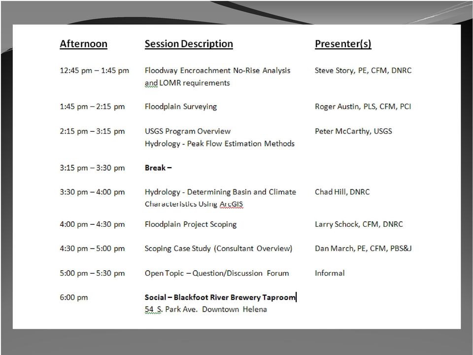
6 Course Introduction Ideas for Floodplain Eng. 201/301 Course Topics: Case Study Example Workshops: LOMA (MT-1/MT-EZ Forms) LOMR (MT-2 Forms) Elevation Certificate Permit Application Hydrology Peak Flow Determination Hydraulics HEC-RAS Modeling & Floodway Other??

7 Course Introduction Additional Training: ASFPM Certified Floodplain Manager (CFM): 55 and growing in MT FEMA 480 Study/Reference Guide Day Course: Introduction to Floodplain Hydraulics Using HEC-RAS Denver Course in May was $595.00

8 Traci Sears, CFM State NFIP Coordinator Celinda Adair, CFM, CPP MapMod/RiskMap Coordinator Steve Story, PE, CFM State Floodplain Engineer

9 Floodplain Program Overview Presentation Topics: NFIP Introduction/Review Regulations Roles & Responsibilities DNRC Floodplain Program Technical Resources Images Courtesy Watershed Sciences, Inc.

10 National Flood Insurance Program (NFIP) The NFIP is based upon a voluntary mutual agreement between the federal government (administered i d by DHS/FEMA) and participating communities (counties & municipalities) across the country. The Agreement. Community must: Adopt/enforce local floodplain regulations And in return, Federal Government provides: Availability of flood insurance

11 NFIP History 1968 The NFIP was established by Congress on August 1, 1968 with the passage of the National Flood Insurance Act The program was broadened d and modified d with the passage of the Flood Disaster Protection Act of Additional modifications were incorporated through the National Flood Insurance Reform Act of The NFIP is administered by the Federal Emergency Management Agency (FEMA); a division ision of the Department of Homeland Security (DHS).

12 NFIP Participation i Community yparticipation p is voluntary However, there are ramifications of non-participation: Federal Flood Insurance not available Non-eligibility ibilit of post-disaster t financial i assistance NFIP participation required to receive assistance

13 NFIP Participation i Requirements Participating communities must adopt & enforce a floodplain l management ordinance that t meets or exceeds the minimum NFIP criteria (specified under Chapter 44, Section 60.3 of the Code of Federal Regulations (CFR)) Continued Eligibility based on compliance with program regulations and enforcement of the adopted ordinance. Compliance is monitored by FEMA via an audit process called a Community Assistance Visit (CAV).

14 NFIP Community Status Book shtm

15 NFIP Framework There are 3 basic parts to the NFIP 1.) Regulations 2.) Insurance 3.) Mapping ** Mitigation Clark Fork R. near Plains, Sanders County
 Mapping ** Mitigation Clark Fork R.")
16 NFIP Regulations The NFIP underwrites insurance coverage only in those communities that adopt and enforce regulations. The regulations are designed to protect new structures from the flood levels projected on the FEMA regulatory flood maps (FIRM Flood Insurance Rate Map) Regulations focus on protecting insurable buildings. Communities must meet NFIP criteria of 44 CFR gov/nara/cfr/waisidx html
 Regulations focus on protecting insurable buildings.")
17 NFIP Regulations NON-COMPLIANCE Failure to enforce an ordinance 1.) Reclassification under the Community Rating System (CRS) 2.) Probation Policy holders pay additional $50 premium during this period 3.) Suspension Community no longer in NFIP
 Probation Policy holders pay additional $50 premium during")
18 NFIP Regulations SANCTIONS FOR NON-PARTICIPATION/SUSPENSION Flood Insurance will not be available Existing insurance policies not renewed No Federal grants or loans available for development within the SFHA No Federal disaster assistance available No Federal mortgage insurance or loan guarantees may g g g y be provided in SFHA

19 Knowing the Regulations Floodplain Regulations/Ordinances Must meet or exceed requirements specified in 44 CFR Must meet or exceed requirements of the Montana Administrative Rules.

20 Knowing the Regulations State Regulations MT CODE ANNOTATED (MCA) - STATUTES: laws passed by the legislature. All changes must go through the legislative process and be passed into law before they become effective. Montana Floodplain and Floodway Management Act - MCA Title 76, Chapter 5

21 Knowing the Regulations State Regulations ADMINISTRATIVE RULES of MT (ARMs): written and adopted by State agencies. The State agencies write rules in order to administer the laws over which the Legislature has given the agencies authority. Rules can be changed by going through the rule making procedure and do NOT go through the Legislative process. DNRC Floodplain Management Engineering Bureau - ARM Rule 36, Chapter 15 (adopted 12/31/1989)
22 The Montana Rules vs. NFIP Minimum Requirements Standard Montana Administrative Rules NFIP Minimum Requirements Freeboard 2 Feet No freeboard required Floodway Standards 1/2 foot Surcharge 1 Foot Surcharge Floodway Uses Mobile Home Applications Prohibits habitable structures with/in the floodway Requires all mobile homes to be elevated to the freeboard protection level. Allows structures in Floodway with documentation of zero-riserise Will allow for mobile home placed in and existing mobile home park to be elevated to 36 above the adjacent grade.
23 The Montana Rules ARM (6) The designated floodplain boundary is based on base flood elevations. The mapped floodplain l boundary may be used as a guide for determining whether property is within the designated floodplain, but the exact boundary shall be determined according to the base flood elevation. If the local administrator determines it is unclear whether property is in or out of the floodplain, l the local l administrator i t shall require the applicant to provide additional information which may include elevations obtained through a level survey performed by a PE or PLS.
24 Floodplain Management Roles & Responsibilities The FEDERAL ROLE (FEMA): Administers the NFIP through Regional Offices MT is in Region VIII (
25 Floodplain Management Roles & Responsibilities The FEDERAL ROLE (FEMA): Monitors community compliance with NFIP requirements. Provides guidance & assistance to State and community administrators. Provides information, training, and outreach. Helps review and adopt new maps and data.
26 Floodplain Management Roles & Responsibilities The STATE ROLE (DNRC): Enable communities with the legal authorities needed to adopt and enforce floodplain management regulations. Establish minimum State regulatory standards consistent with the NFIP. Provide program and technical assistance to participating local governments. Coordinate activities of various State agencies that affect Coordinate activities of various State agencies that affect the NFIP.
27 Floodplain Management Roles & Responsibilities The COMMUNITY ROLE: Local adoption and enforcement of floodplain management regulations meeting or exceeding the minimum NFIP criteria. Require floodplain development permits for development within the 1-percent-annual-chance flood inundation area (aka Special Flood Hazard Area (SFHA) or 100-year floodplain). Additional requirements per 44 CFR 60.3.
28 DNRC State Floodplain Management Program Program Organization & Staff State Floodplain Programs WEBSITE: l t with contact, permitting, regulation, resource info & more Image Courtesy Watershed Sciences, Inc.
29
30 Chad Hill Civil Eng. Specialist th Avenue PO Box Helena, MT
31 DNRC Regional Engineering Specialists
32 DNRC State Floodplain Management Program Floodplain Hazard Mitigation Assistance Program (FHMAP) Community Assistance Program (CAP) Traci Sears Activities i i - Community Compliance - CAV/CACs - Ordinance Assistance - Updating data into Community Info System (CIS) - 5 year plan updates - State model ordinance updates - Outreach, workshops, & training - General Technical Assistance - Map Coordination, Disaster Assistance & more
33 DNRC State Floodplain Management Program Floodplain Hazard Mitigation Assistance Program (FHMAP) Map Mod/Risk MAP Program Celinda Adair Activities: Grant Writing, Contract/Grant Administration, & Project Management FEMA funded Map Mod/Risk MAP projects Business Plan Creation - MT Map Mod/Risk MAP program Floodplain Mapping Needs Identification/Prioritization Program/Project Related Outreach & Training Building Match, Partnerships, Collaboration DFIRM Distribution & Maintenance Earned Value Tracking Mapping Information Platform (MIP)
34
35
36 Use of FIS Data as Available Data FEMA Floodplain Management Bulletin 1-98: Covers Community use of Draft or Preliminary FIS data as best available data * Constitutes available data under 44 CFR 60.3(b)(4) - Obtain, review and reasonably utilize any base flood elevation and floodway data available from a Federal, State, or other source
37 DNRC State Floodplain Management Program Floodplain Hazard Mitigation Assistance Program (FHMAP) State Floodplain Engineer Steve Story Provides engineering i technical assistance to state programs (CAP, Map Mod/Risk Map), performs/reviews floodplain studies, community assistance, special projects, training & outreach. Outreach Coordinator Mary Guokas Leads outreach efforts in coordination with CAP and Map Mod/Risk Map programs, prepares quarterly Highground Newsletters, attends conferences, & more
38 Flathead Basin Lidar & Imagery Project Funding Partners: FBC, Lake County, & City of Whitefish 500 sq mi Coverage Area Products: 2 Contours, DEMs, True Color & Color Infrared Images Courtesy Watershed Sciences, Inc.
39 WORM Map Project One of several tasks funded d through EPA Grant Work completed using DNRC GIS & Engineering Staff GIS layers created that show effective FIRM/FHBM regulatory floodplains. Lines only, not boundaries. Does NOT replace FIRM/FHBMs. Categories: Detailed, Limited Detail, & Approximate Status: Drafts being distributed this fall to communities
40 For Approximate Zone A or Unmapped Areas Surveying, Hydrology, and Hydraulics Larry Schock, CFM Missoula Regional Engineering Specialist
41 DNRC Technical Resources Introduction Since the DNRC offers complimentary engineering technical support to the NFIP communities, there arose a need dto provide technical resources for the consulting sectors. The technical resources that have been developed by the DNRC are basic guidelines to help explain some of the more complex tasks in the floodplain process. Some sections of these documents have become dated and being updated, therefore they should be considered DRAFT documents.
42 DNRC Technical Resources Surveying Guidelines Guidelines For Water Course Surveys In Undesignated or Zone A Flood Zones This can be found at the DNRC Floodplain Website
43 DNRC Technical Resources Surveying Guidelines The document is intended to describe the minimum topographic requirements needed in order to construct a reasonably reliable hydraulic model. The process described within the document is only intended for use on limited reaches of the water course. The document also outlines submittal requirements.
44 DNRC Technical Resources Surveying Guidelines Each site is unique and can pose distinct problems. It is important for the landowner, surveyor, and the engineer to review the proposed project to insure that everyone understands the scope of the survey. A site visit by all parties will insure all of the features needed to construct a reliable model are surveyed.
45 DNRC Technical Resources Surveying Guidelines
46 DNRC Technical Resources Surveying Guidelines
47 DNRC Technical Resources Surveying Guidelines Special attention should be taken at abrupt channel constrictions and expansions. Equal Distance Between Both Point Where Contraction Begins Direction of Flow Point Where Contraction Ends Edge of Floodplain
48 DNRC Technical Resources Surveying Guidelines The document : Discusses the level of data and documentation that must be submitted in order for DNRC review the project. Provides examples of the format that should be used when submitting the data. Failure to submit all of the required data, in the proper format, may result in DNRC review delays.
49 DNRC Technical Resources Hydrology and Hydraulic Guidelines Guidelines For Obtaining 100 Year Flood Elevations In Approximate Zone A or Unmapped Areas This document is intended to describe the minimum requirements needed in order to construct a reasonably reliable hydraulic model The guidelines are for models to determine the 100 yr. Base Flood Elevations (BFE) on limited it reaches of a water course
50 DNRC Technical Resources Hydrology and Hydraulic Guidelines Some sections of this document has become dated and is being updated, therefore it should be considered a DRAFT document These guidelines are not all encompassing The DNRC recognizes the many situations and sites are unique and may require analyses not covered in the guideline
51 h i lr DNRC T Technical Resources Hydrology and Hydraulic Guidelines y Hydrology is based upon the protocol and guidelines established in USGS Water-Resources Investigations g Report p , Methods for Estimating Flood F Frequency in i Montana M t Based on Data through Water Year 1998
52 DNRC Technical Resources Hydrology and Hydraulic Guidelines Depending upon the type of proposed development, a hydraulic analysis can be completed using either a normal depth method or a standard step backwater methodology Normal Depth Method = Manning s Equation Standard Step Backwater Methodology = HEC-RAS
53 DNRC Technical Resources Hydrology and Hydraulic Guidelines The Standard Step Backwater Method is almost exclusively done using computer programs, and HEC-RAS is the FEMA and DNRC preferred program Use of other programs should be approved prior to submittal A disc with the HEC RAS input and output files is A disc with the HEC-RAS input and output files is required for DNRC review
54 DNRC Technical Resources Hydrology and Hydraulic Guidelines If your intent is to perform a detailed study which includes a regulatory Floodway and Floodfringe for the LOMR process you must refer to FEMA guidelines If your intent is to provide a No Rise Certification for a project within a FEMA detailed study area you must refer to FEMA guidelines.
55 DNRC Technical Resources Hydrology and Hydraulic Guidelines Submittal Requirements are listed in Appendix A of the document. Floodplain applications, and materials used in their preparation, fall within the public domain. Failure to submit the required data will delay the Failure to submit the required data will delay the review of the application.
56 DNRC Technical Resources Surveying, Hydrology, and Hydraulics The DNRC is currently in the process of updating existing resources and developing new resources Currently soliciting for your input, comments, and recommendations. please submit to: Bri Shipman:
57 Questions? Thank You Traci Sears, CFM Steve Story, PE, CFM Celinda Adair, CFM, CPP Larry Schock, CFM Image Courtesy Watershed Sciences, Inc.
Criteria for Appeals of Flood Insurance Rate Maps
 Criteria for Appeals of Flood Insurance Rate Maps November 30, 2011 This document outlines the criteria for appealing proposed changes in flood hazard information on Flood Insurance Rate Maps (FIRMs)
Madison Preliminary Flood Map Open House Community Meeting
 Madison Preliminary Flood Map Open House Community Meeting December 9, 2010 INTRODUCTION Welcome to the Madison County, AL Preliminary Flood Map Open House Meeting The Office of Water Resources (OWR),
FEMA Updates Flood Plain Information For 2006
 Flood Insurance Rate Map Changes Informational Meeting For Property Owners Entering the Floodplain Durant Center February 23, 2011 Introductions City of Alexandria Transportation and Environmental Services
FEMA Elevation Certificate
 FEMA Elevation Certificate 2013 MARLS Conference Larry Schock, CFM DNRC Missoula Regional Office (406) 542-5885 lschock@mt.gov FEMA Elevation Certificate Presentation Overview National Flood Insurance
Town of Chatham Department of Community Development
 Town of Chatham Department of Community Development TOWN ANNEX 261 GEORGE RYDER ROAD 02633 CHATHAM, MA TELEPHONE (508) 945-5168 FAX (508) 945-5163 FEMA FLOOD MAP UPDATE & PROPOSED ZONING BYLAW AMENDMENT
Section 5 Floodplain Management Tools
 5.1 Floodprone Areas One of the major elements of the Master Plan is the updated 100-year floodplain and floodway boundary maps. This information provided the most up-to-date tools to protect homes and
National Flood Insurance Program (NFIP)
") National Flood Insurance Program (NFIP) Saunders County, Nebraska Preliminary Flood Insurance Rate Maps CCO Meeting February 12, 2015 Agenda Introductions and Roles National Flood Insurance Program (NFIP)
National Flood Insurance Program (NFIP) Saunders County, Nebraska Preliminary Flood Insurance Rate Maps CCO Meeting February 12, 2015 Agenda Introductions and Roles National Flood Insurance Program (NFIP)
What We Do: Wetlands, Wildlife Habitat & Flood Hazards in the Root River Watershed
 What We Do: Wetlands, Wildlife Habitat & Flood Hazards in the Root River Watershed presented by Ceil Strauss, State Floodplain Manager DNR Ecological & Water Resources 1 EWR Roles In Floodplains Regulatory:
6.01 FEMA. 6.02 National Flood Insurance Program (NFIP)
") CHAPTER 6 FEMA AND FLOODPLAIN MANAGEMENT 6.01 FEMA The Federal Emergency Management Agency (FEMA) is an agency of the United States Department of Homeland Security. FEMA is tasked with responding to, planning
CHAPTER 6 FEMA AND FLOODPLAIN MANAGEMENT 6.01 FEMA The Federal Emergency Management Agency (FEMA) is an agency of the United States Department of Homeland Security. FEMA is tasked with responding to, planning
Town of Hingham. Changes to Flood Insurance Rate Maps and Flood Insurance Costs Frequently Asked Questions
 Town of Hingham 1. What is a floodplain? Changes to Flood Insurance Rate Maps and Flood Insurance Costs Frequently Asked Questions A floodplain is an area of land where water collects, pools and flows
Floodplain Management Today
 Newsletter Date Floodplain Management Today NEBRASKA DEPARTMENT OF NATURAL RESOURCES FLOODPLAIN SECTION FEBRUARY 2014 September 2013 Flooding After the significant rainfall in mid- September 2013 in the
Adoption of Flood Insurance Rate Maps by Participating Communities. FEMA 495 / September 2012
 Adoption of Flood Insurance Rate Maps by Participating Communities FEMA 495 / September 2012 Adoption of Flood Insurance Rate Maps by Participating Communities 1 Adoption of Flood Insurance Rate Maps by
SARASOTA COUNTY Dedicated to Quality Service
 SARASOTA COUNTY Dedicated to Quality Service Florida Flood Map Updates and the National Flood Insurance Program Joy Duperault, CFM State of Florida NFIP Coordinator Desiree (Des) Companion, CFM CRS Coordinator
MITIGATION STRATEGY- Flood #1 Map Modernization: New FIRM Adoption by Communities
 MITIGATION STRATEGY- Flood #1 Map Modernization: New FIRM Adoption by Communities into a performance-based program, with measurable outcomes or output. The priority Outcome required by FEMA is the maintenance
Professional Civil Engineers Certified Floodplain Managers
 Professional Civil Engineers Certified Floodplain Managers Floodplain Management Flood Zone Modifications J.R. EVANS ENGINEERING 23150 Fashion Drive, Ste. 242 Estero, FL 33928 O 239.405.9148 F 239.288.2537
CHAPTER 3 page 69 LOCAL FLOODPLAIN REGULATIONS AND NFIP STANDARDS
 CHAPTER 3 page 69 LOCAL FLOODPLAIN REGULATIONS AND NFIP STANDARDS LOCAL FLOODPLAIN REGULATIONS AND NFIP STANDARDS, page 69 THE PARTICIPATION OF A COMMUNITY IN THE NFIP IS MADE POSSIBLE BY ITS ADOPTION
NAFSMA Position on Floodplain Management Issues
 National Association of Flood & Stormwater Management Agencies PO Box 56764, Washington, DC 20040 202-289-8625 www.nafsma.org I. Introduction NAFSMA Position on Floodplain Management Issues (Approved on
Federal Emergency Management Agency Region IV 3003 Chamblee-Tucker Road Atlanta, GA 30341
 Federal Emergency Management Agency Region IV 3003 Chamblee-Tucker Road Atlanta, GA 30341 GUIDANCE FOR "NO-RISE / NO-IMPACT" CERTIFICATION FOR PROPOSED DEVELOPMENTS IN REGULATORY FLOODWAYS The National
Levee Certification/Accreditation Process Cameron and Hidalgo Counties
 Levee Certification/Accreditation Process Cameron and Hidalgo Counties Lower Rio Grande Citizens Forum October 21, 2009 Larry Voice Background As administrator of the National Flood Insurance Program (NFIP),
Procedures for No-Rise Certification For Proposed Developments in the Regulatory Floodway
 US Department of Homeland Security Region X 130 228 th Street, SW Bothell, WA 98021 Procedures for No-Rise Certification For Proposed Developments in the Regulatory Floodway Section 60.3 (d) (3) of the
Overview of the National Flood Insurance Program (NFIP) and Recent Flood Mapping Efforts. Richard Zingarelli
 and Recent Flood Mapping Efforts. Richard Zingarelli") Overview of the National Flood Insurance Program (NFIP) and Recent Flood Mapping Efforts Richard Zingarelli State NFIP Program Coordinator Commonwealth of Massachusetts Department of Conservation and Recreation
Overview of the National Flood Insurance Program (NFIP) and Recent Flood Mapping Efforts Richard Zingarelli State NFIP Program Coordinator Commonwealth of Massachusetts Department of Conservation and Recreation
DRAFT Map Modernization Plan for The State of Ohio. Prepared by The Ohio Department of Natural Resources Division of Water Columbus, Ohio
 DRAFT Map Modernization Plan for The State of Ohio Prepared by The Ohio Department of Natural Resources Division of Water Columbus, Ohio DRAFT Map Modernization State for Ohio DRAFT Ohio Map Modernization
And Flood Resilient Design in Austin, Texas
 And Flood Resilient Design in Austin, Texas The good, the bad and the ugly; What does this video show us? Riverine Flooding versus Flash Flooding Flash Flood Alley Stretches along the I 35 corridor between
Relationship between Floodplain Management and Flood Insurance
 Relationship between Floodplain Management and Flood Insurance The National Flood Insurance Program [is] a voluntary program based on a mutual agreement between the Federal government and the local community:
[Docket ID FEMA-2016-0002; Internal Agency Docket No. FEMA-B-1550] AGENCY: Federal Emergency Management Agency, DHS.
![[Docket ID FEMA-2016-0002; Internal Agency Docket No. FEMA-B-1550] AGENCY: Federal Emergency Management Agency, DHS.](/thumbs/31/15316247.jpg "[Docket ID FEMA-2016-0002; Internal Agency Docket No. FEMA-B-1550] AGENCY: Federal Emergency Management Agency, DHS.") This document is scheduled to be published in the Federal Register on 02/11/2016 and available online at http://federalregister.gov/a/2016-02747, and on FDsys.gov 1 Billing Code 9110-12-P DEPARTMENT OF
This document is scheduled to be published in the Federal Register on 02/11/2016 and available online at http://federalregister.gov/a/2016-02747, and on FDsys.gov 1 Billing Code 9110-12-P DEPARTMENT OF
Division of Water Frequently asked floodplain questions
 Division of Water Frequently asked floodplain questions Q: Where can I find copies of the floodplain mapping? A: Local floodplain administrators will have copies of the FEMA mapping. (Generally the local
Building Olive s Flood Resiliency
 Building Olive s Flood Resiliency Informed Flood Mitigation Planning The Local Flood Analysis Flood Advisory Committee Meeting #1 Town of Olive s Community Room 4/14/15 What is an LFA? 1. Uses science
Elevations Certificates: Update 2009 Presented by Wendy Lathrop, PLS, CFM
 Elevations Certificates: Update 2009 Presented by Wendy Lathrop, PLS, CFM The objectives of the National Flood Insurance Program (NFIP): Reduce the exposure to flood damages through the use of minimum
Changing Flood Maps: A Guide for Homeowners and Consumers
 Changing Flood Maps: A Guide for Homeowners and Consumers The flood maps in your community are being changed. What does this mean to you? Flood maps, also known as Flood Insurance Rate Maps or FIRMs, are
ASFPM Update. FMA Annual Conference
 ASFPM Update FMA Annual Conference AND HE SAID Floods are 'acts of God,' but flood losses are largely acts of man. 1945 PhD Dissertation Human Adjustments to Flood by Gilbert F. White ASFPM s Mission Mitigate
Page Intentionally Left Blank
 Flood Map Modernization Mid-Course Adjustment March 30, 2006 Page Intentionally Left Blank Table of Contents Executive Summary... iii 1. Introduction...1 1.1. Purpose of Report...1 1.2. Background...1
July 20, 2015. Subject: 7 th Avenue Creek Project Update & Elevation Certificates
 July 20, 2015 Subject: 7 th Avenue Creek Project Update & Elevation Certificates Below are a few updates regarding the 7 th Avenue Creek Project. As you may recall there are two concurrent and independent
Adoption of Flood Insurance Rate Maps by Participating Communities
 Adoption of Flood Insurance Rate Maps by Participating Communities FEMA 495/September 2005 Adoption of Flood Insurance Rate Maps By Participating Communities The National Flood Insurance Program (NFIP)
1. GENERAL ADVISORY BASE FLOOD ELEVATION (ABFE) QUESTIONS
 QUESTIONS") INTRODUCTION As communities begin to recover from the devastating effects of Hurricane Sandy, it is important to recognize lessons learned and to employ mitigation actions that ensure structures are rebuilt
INTRODUCTION As communities begin to recover from the devastating effects of Hurricane Sandy, it is important to recognize lessons learned and to employ mitigation actions that ensure structures are rebuilt
A. Flood Management in Nevada
 Nevada Division of Water Planning A. Flood Management in Nevada Introduction Flooding has been a concern for Nevada communities since the first settlers moved to the territory in the mid-1800 s. Fourteen
How To Build A Floodproofed Basement
 General Basement Exception Guidelines National Flood Insurance Program (NFIP) floodplain management criteria at 44 CFR 60.6 (c) provide for the granting of exceptions to permit construction of floodproofed
Chapter 10. The National Flood Insurance Program
 Chapter 10 The National Flood Insurance Program Chapter Overview The National Flood Insurance Program has been mentioned in numerous instances in preceding chapters. Its time has arrived in this course!
Flood insurance why have it? Where can I buy it?
 Flood insurance why have it? Where can I buy it? NOAA/National Weather Service Des Moines, Iowa June 2010 Thank you for your interest in flood insurance. Below are frequently asked questions and answers
[Docket ID FEMA-2015-0001; Internal Agency Docket No. FEMA-B-1548] AGENCY: Federal Emergency Management Agency, DHS.
![[Docket ID FEMA-2015-0001; Internal Agency Docket No. FEMA-B-1548] AGENCY: Federal Emergency Management Agency, DHS.](/thumbs/32/15537544.jpg "[Docket ID FEMA-2015-0001; Internal Agency Docket No. FEMA-B-1548] AGENCY: Federal Emergency Management Agency, DHS.") This document is scheduled to be published in the Federal Register on 01/19/2016 and available online at http://federalregister.gov/a/2016-00772, and on FDsys.gov 1 Billing Code 9110-12-P DEPARTMENT OF
This document is scheduled to be published in the Federal Register on 01/19/2016 and available online at http://federalregister.gov/a/2016-00772, and on FDsys.gov 1 Billing Code 9110-12-P DEPARTMENT OF
National Flood Insurance Program, Mitigation and the Community Rating System
 National Flood Insurance Program, Mitigation and the Community Rating System 2015 Preparedness Conference August 25, 2015 BACKGROUND National Flood Insurance Program (NFIP) Provides flood insurance to
Focus Areas: Program/Project Management, Repetitive Loss Properties, Flood Map Modernization, Standard Business Processes.
 NATIONAL FLOOD INSURANCE PROGRAM Focus Areas: Program/Project Management, Repetitive Loss Properties, Flood Map Modernization, Standard Business Processes. Sponsoring Executive: Lead Executive: Susan Shuback,
Essex County, NJ. Preliminary Flood Insurance Study & Flood Insurance Rate Maps Release. FEMA Region 2 May 29, 2014
 Essex County, NJ Preliminary Flood Insurance Study & Flood Insurance Rate Maps Release FEMA Region 2 May 29, 2014 Agenda Introduction Review: Preliminary Work Maps (July 2013) Preliminary Flood Insurance
MAP TYPES FLOOD HAZARD BOUNDARY MAP MAP READING & FLOOD INSURANCE STUDIES. FHBM Flood Hazard Boundary Map. FIRM Flood Insurance Rate Map
 FLOODPLAIN MANAGEMENT 101 MAP READING & FLOOD INSURANCE STUDIES MAP TYPES FHBM Flood Hazard Boundary Map FIRM Flood Insurance Rate Map FBFM Flood Boundary and Floodway Map DFIRM Digital Flood Insurance
An Introduction to FEMA Flood Map Updates and How it Affects You
 An Introduction to FEMA Flood Map Updates and How it Affects You Presented by Michael Baker Jr., Inc. on behalf of the City of Reno Agenda Session 1 5:30-6:00 FEMA Flood Map Changes Program Slide Show
PRELIMINARY DIGITAL FLOOD INSURANCE RATE MAPS (DFIRM)
") INTRODUCTION This Mississippi Guidance document has been prepared to explain to community officials how the Preliminary Digital Flood Insurance Rate Maps (DFIRMs) and Preliminary Flood Insurance Study
INTRODUCTION This Mississippi Guidance document has been prepared to explain to community officials how the Preliminary Digital Flood Insurance Rate Maps (DFIRMs) and Preliminary Flood Insurance Study
Frequently Asked Questions (FAQs) 1. Why is the City of Tucson getting new flood hazard maps? 2. Who is responsible for modernizing the maps?
 1. Why is the City of Tucson getting new flood hazard maps? 2. Who is responsible for modernizing the maps?") Frequently Asked Questions (FAQs) 1. Why is the City of Tucson getting new flood hazard maps? 2. Who is responsible for modernizing the maps? 3. What is a Flood Hazard Map? 4. What are the benefits of
Frequently Asked Questions (FAQs) 1. Why is the City of Tucson getting new flood hazard maps? 2. Who is responsible for modernizing the maps? 3. What is a Flood Hazard Map? 4. What are the benefits of
FEMA s FLOOD INSURANCE RATE MAPS
 My Lender is requiring me to purchase Flood Insurance Options for San Diego County Residents in Unincorporated Areas This document is intended to help San Diego County residents who have been contacted
Shooks Run Drainage Study Basic Terminology
 Shooks Run Drainage Study Basic Terminology PREPARED FOR: PREPARED BY: City of Colorado Springs CH2M DATE: April 9, 2015 Introduction This document is intended to provide an introduction to Colorado Springs
Monmouth County Preliminary Flood Insurance Study and Flood Insurance Rate Maps Release
 Monmouth County Preliminary Flood Insurance Study and Flood Insurance Rate Maps Release Thomas Song, Program Specialist FEMA Region 2 January 31, 2014 Agenda Introduction Review: Preliminary Work Maps
James City County and Williamsburg Open House Meeting
 James City County and Williamsburg Open House Meeting What the New Preliminary Flood Insurance Rate Maps (FIRMs) Mean for Your Community and for You as a Property Owner August 13, 2014 1 Today s Open House
Map Modernization and DFIRMs. Dr. Shane Parson, PE, CFM
 Map and DFIRMs Dr. Shane Parson, PE, CFM URS Corp. Acknowledgements Insurance portions of this presentation were originally given at ASFPM Conference by Bruce A. Bender; FloodSmart/Bender Consulting Services,
Recent Innovations In Virginia Dam Safety & Floodplain Management Program
 Recent Innovations In Virginia Dam Safety & Floodplain Management Program Robert T. Bennett, P.E., R.A., C.F.M. Director Dam Safety & Floodplain Management Virginia Department of Conservation & Recreation
rescue and relief efforts in the aftermath of flooding, (iii) repair of flood damaged public facilities and utilities, and
 repair of flood damaged public facilities and utilities, and") 1. Purpose (1) It is the purpose of this Ordinance to protect human life, health, and property from flood conditions, to preserve the ability of floodplains to carry and discharge a base flood, and to
1. Purpose (1) It is the purpose of this Ordinance to protect human life, health, and property from flood conditions, to preserve the ability of floodplains to carry and discharge a base flood, and to
Mercer County, New Jersey Flood Hazard Mapping Status Report for Property Owners
 Mercer County, New Jersey Flood Hazard Mapping Status Report for Property Owners Mercer County, New Jersey Flood Hazard Mapping Status Report for Property Owners FLOOD INSURANCE Who Should Purchase Flood
CHICKASAW COUNTY, MISSISSIPPI, AND INCORPORATED AREAS
 CHICKASAW COUNTY, MISSISSIPPI, AND INCORPORATED AREAS Chickasaw County Community Name Community Number CHICKASAW COUNTY 280269 (UNINCORPORATED AREAS) HOUSTON, CITY OF 280030 NEW HOULKA, TOWN OF 280067
DEPARTMENT OF HOMELAND SECURITY FEDERAL EMERGENCY MANAGEMENT AGENCY STANDARD FLOOD HAZARD DETERMINATION FORM (SFHDF)
") Flood Determination The flood status of a property (and therefore the requirement for flood insurance) is based on whether a FEMA-designated Special Flood Hazard Area (100 year flood zone) touches a structure
Flood Determination The flood status of a property (and therefore the requirement for flood insurance) is based on whether a FEMA-designated Special Flood Hazard Area (100 year flood zone) touches a structure
How to Read a Flood Insurance Rate Map Tutorial. Developed September 2000 Updated June 2003
 How to Read a Flood Insurance Rate Map Tutorial Developed September 2000 Updated June 2003 Learning Objectives: The Objectives of the tutorial are: 1. To show the various types of flood maps, 2. To describe
AGENCY: Federal Emergency Management Agency, DHS. SUMMARY: Comments are requested on proposed flood hazard determinations, which
 This document is scheduled to be published in the Federal Register on 09/19/2013 and available online at http://federalregister.gov/a/2013-22832, and on FDsys.gov 1 Billing Code 9110-12-P DEPARTMENT OF
Frequently-Asked Questions about Floodplains and Flood Insurance FLOOD INSURANCE
 Frequently-Asked Questions about Floodplains and Flood Insurance What is a floodplain? The floodplain is any area covered by water during normal water flows, and which could be inundated as a result of
Chapter 4 Flood Risk Management
 Chapter 4 Flood Risk Management Contents 1.0 Introduction... 1 2.0 Floodplain Management Fundamentals... 2 2.1 Basic Definitions... 2 2.1.1 Floodplain... 2 2.1.2 100-year Flood/Base Flood... 3 2.1.3 Base
Flood Insurance Coverage/Rates Summary Excerpted From Unit 9 of Managing Floodplain Development Through the National Flood Insurance Program
 Flood Insurance Coverage/Rates Summary Excerpted From Unit 9 of Managing Floodplain Development Through the National Flood Insurance Program Amount of coverage Insurance rates for all buildings are based
Rockford s map update project is a joint effort with FEMA in cooperation with local associations and other state partners.
 FREQUENTLY ASKED QUESTIONS 1. Why is Rockford getting new flood hazard maps? Flood hazard maps, also known as Flood Insurance Rate Maps (FIRMs), are important tools in the effort to protect lives and properties
The answers to some of the following questions are separated into two major categories:
 Following the recent flooding events for Front Range communities in Colorado, property owners, communities, and the National Flood Insurance Program are being presented with some new challenges in the
Risk MAP Project Coordination Meeting: Burlington County, NJ. FEMA REGION II May 8, 2013 Westampton, New Jersey
 Risk MAP Project Coordination Meeting: Burlington County, NJ FEMA REGION II May 8, 2013 Westampton, New Jersey Agenda Introductions Purpose of this Meeting Risk MAP Program Overview Anticipated Project
Certified Floodplain Management and Land Development Design and Entitlement
 Certified Floodplain Management and Land Development Design and Entitlement J.R. EVANS ENGINEERING 23150 Fashion Drive, Ste. 242 Estero FL 33928 P 239.405.9148 F 239.288.2537 www.jreva ns eng ineering.com
Indiana Office of Community and Rural Affairs. Disaster Recovery and Mitigation Planning Ft. Worth, Texas February 15, 2012
 Indiana Office of Community and Rural Affairs Disaster Recovery and Mitigation Planning Ft. Worth, Texas February 15, 2012 Floods Indiana s costliest hazard State ranks 5 th in annual median flood damages
RESPONSE TO COMMENTS AND SUGGESTIONS 2013 MODEL REGUATIONS September 3, 2013 version Montana Department of Natural Resources and Conservation
 RESPONSE TO COMMENTS AND SUGGESTIONS 2013 MODEL REGUATIONS September 3, 2013 version Montana Department of Natural Resources and Conservation February 24, 2013 A comment was to use consistently, either
NATIONAL FLOOD INSURANCE PROGRAM (NFIP): THE BASICS & UPDATE
: THE BASICS & UPDATE") May 19, 2015 NATIONAL FLOOD INSURANCE PROGRAM (NFIP): THE BASICS & UPDATE ON THE CURRENT STATE Mary-Carson Stiff, JD, CFM Shannon Hulst Jarbeau, CFM Closing the Deal: How to respond to the new realities
May 19, 2015 NATIONAL FLOOD INSURANCE PROGRAM (NFIP): THE BASICS & UPDATE ON THE CURRENT STATE Mary-Carson Stiff, JD, CFM Shannon Hulst Jarbeau, CFM Closing the Deal: How to respond to the new realities
CFM REVIEW COURSE September 30, 2014 Vail, CO
 CFM REVIEW COURSE September 30, 2014 Vail, CO CFM PURPOSE The primary goal of the ASFPM Certified Floodplain Manager Program (CFM Program) is to help reduce the nation s flood losses and protect and enhance
Frequently Asked Questions (FAQs)
") 1. Why is Cedar Rapids getting new flood hazard maps? Flood hazard maps, also known as Flood Insurance Rate Maps (FIRMs), are important tools in the effort to protect lives and properties in Cedar Rapids.
1. Why is Cedar Rapids getting new flood hazard maps? Flood hazard maps, also known as Flood Insurance Rate Maps (FIRMs), are important tools in the effort to protect lives and properties in Cedar Rapids.
COMMUNITY CERTIFICATIONS
 National Flood Insurance Program Community Rating System COMMUNITY CERTIFICATIONS Public reporting burden for this form is estimated to average 4 hours for annual recertification, per response. The burden
NWS Flood Inundation Mapping Program
 NWS Flood Inundation Mapping Program Carson River Floodplain Management Forum April 22, 2015 Mark Faucette, Senior Forecaster Hydrology Program Manager NOAA/NWS, WFO Reno, NV NWS Hydrologic Services Program
Flood Insurance for Risk Managers
 Flood Insurance for Risk Managers Basics of the National Flood Insurance Program August 20, 2012 Susan W. Wilson DHS/FEMA Region IV NFIP Created by National Flood Insurance Act of 1968 THIS Adopt a local
Frequently Asked Questions (FAQs)
") 1. Why is Shawnee County getting new flood hazard maps? Flood hazard maps, also known as Flood Insurance Rate Maps (FIRMs), are important tools in the effort to protect lives and properties throughout
1. Why is Shawnee County getting new flood hazard maps? Flood hazard maps, also known as Flood Insurance Rate Maps (FIRMs), are important tools in the effort to protect lives and properties throughout
CANCELLATION/NULLIFICATION
 CANCELLATION/NULLIFICATION Flood insurance coverage may be terminated at any time, by either canceling or nullifying the policy depending upon the reason for the transaction. If coverage is terminated,
FEMA Flood Zone Designations
 Note: SFHA "Special Flood Hazard Area" FEMA Flood Zone Designations Zone VE Zone A Zone AE Zone X Zone X500 UNDES along coasts subject to inundation by the 100-year flood with additional hazards due to
Understanding Flood Map Modernization
 Understanding Flood USING PRELIMINARY FLOOD HAZARD MAPS RELEASING PRELIMINARY FLOOD HAZARD MAPS The release of preliminary flood hazard maps, or Digital Flood Insurance Rate Maps (DFIRMs), is an important
DANIELS RUN STREAM RESTORATION, FAIRFAX, VIRGINIA: FLOODPLAIN ANALYSIS REPORT
 DANIELS RUN STREAM RESTORATION, FAIRFAX, VIRGINIA: FLOODPLAIN ANALYSIS REPORT By: Conor C. Shea Stream Habitat Assessment and Restoration Program U.S. Fish and Wildlife Service CBFO-S07-01 Prepared in
NATIONAL FLOOD INSURANCE PROGRAM TRANSITION TO NAVD 88. Elmer C Knoderer, P. E. Dewberry & Davis 8401 Arlington Boulevard Fairfax, VA 22031-4666
 NATIONAL FLOOD INSURANCE PROGRAM TRANSITION TO NAVD 88 Elmer C Knoderer, P. E. Dewberry & Davis 8401 Arlington Boulevard Fairfax, VA 22031-4666 BIOGRAPHICAL SKETCH Elmer C Knoderer received his B. S. in
More Changes Coming to the National Flood Insurance Program What to Expect
 More Changes Coming to the National Flood Insurance Program What to Expect Homeowner Flood Insurance Affordability Act 2014 April 2015 Changes Mark Lujan, CFM, ANFI Biggert Waters Reform Act Targets: Section
FLOOD HAZARD MAPPING. Frequently Asked Questions by Homeowners
 FLOOD HAZARD MAPPING Frequently Asked Questions by Homeowners General National Flood Insurance Program Information 1. What is the National Flood Insurance Program (NFIP)? 2. What are some of the common
Please see Section IX. for Additional Information:
 The Florida Senate BILL ANALYSIS AND FISCAL IMPACT STATEMENT (This document is based on the provisions contained in the legislation as of the latest date listed below.) BILL: CS/SB 1094 Prepared By: The
Homeowner Flood Insurance Affordability Act of 2014 Section by Section Summary
 Homeowner Flood Insurance Affordability Act of 2014 Section by Section Summary On March 21, 2014, President Obama signed into law the Homeowner Flood Insurance Affordability Act of 2014 (HIFAA) (P.L. 113-89).
UNION COUNTY, FLORIDA AND INCORPORATED AREAS
 UNION COUNTY, FLORIDA AND INCORPORATED AREAS COMMUNITY NAME COMMUNITY NUMBER LAKE BUTLER, CITY OF 120595 RAIFORD, TOWN OF 120593 UNION COUNTY 120422 (UNINCORPORATED AREAS) WORTHINGTON SPRINGS, CITY OF
FLOOD HAZARD MANAGEMENT SPECIFIC PLAN GUIDELINES
 INFORMATION BULLETIN / PUBLIC - BUILDING CODE REFERENCE NO.: L.A. Ordinance 172081 Effective: 01-01-2014 DOCUMENT NO.: P/BC 2014-064 Revised: Previously Issued As: P/BC 2011-064 FLOOD HAZARD MANAGEMENT
NYSDEC Optional Additional Language Model Local Law for Flood Damage Prevention Optional Additional Language
 NYSDEC General Comments. The contains language that complies with the floodplain management requirements of the National Flood Insurance Program (NFIP) contained in federal regulations 44 CFR 60.3 through
Flood Maps are Changing
 Flood Maps are Changing What Real Estate Agents Should Know Mississippi coastal counties will soon enter a new era. The Mississippi Coastal Flood Study, undertaken by the Federal Emergency Management Agency
Please see Section IX. for Additional Information:
 The Florida Senate BILL ANALYSIS AND FISCAL IMPACT STATEMENT (This document is based on the provisions contained in the legislation as of the latest date listed below.) BILL: CS/SB 1094 Prepared By: The
Frequently Asked Questions (FAQs)
") 1. Why is Wellesley getting new flood plain maps? Flood plain or flood hazard maps, also known as Flood Insurance Rate Maps (FIRMs), are important tools in the effort to protect lives and properties in
1. Why is Wellesley getting new flood plain maps? Flood plain or flood hazard maps, also known as Flood Insurance Rate Maps (FIRMs), are important tools in the effort to protect lives and properties in
Changes to the National Flood Insurance Program What to Expect
 Changes to the National Flood Insurance Program What to Expect Impact of changes to the NFIP under Homeowner Flood Insurance Affordability Act of 2014 More Changes are Coming to the NFIP On March 21, 2014,
1. Why is the City of Dickinson getting new flood hazard maps?
 FREQUENTLY ASKED QUESTIONS 1. Why is the City of Dickinson getting new flood hazard maps? Flood hazard maps, also known as Flood Insurance Rate Maps (FIRMs), are important tools in the effort to protect
CONDITIONAL LETTER OF MAP REVISION US-34A and US-34D PERMANENT FLOOD REPAIRS
 CONDITIONAL LETTER OF MAP REVISION US-34A and US-34D PERMANENT FLOOD REPAIRS June 25, 2014 REVISED 8/26/2014 Prepared for: Colorado Department of Transportation, Region 4 20068, PR 0342-057 Submitted to:
Back Home Again in Indiana
 Back Home Again in Indiana FEMA REGION VI HAZUS LEVEL 2 PILOT Update August 2010 RAMPP (Risk Assessment, Mapping and Planning Partners) James R. Mawby, CFM - Lead Geographer, Dewberry Joseph C. Kirby,
Preferred Risk Policy (PRP) 2-Year Eligibility Extension
 2-Year Eligibility Extension") Preferred Risk Policy (PRP) 2-Year Eligibility Extension Norm Ashford, FEMA Insurance Specialist 303-235-4912 Norman.ashford@dhs.gov Erin May, NFIP Bureau & Stats Agent, Region VIII, iservice Regional
Preferred Risk Policy (PRP) 2-Year Eligibility Extension Norm Ashford, FEMA Insurance Specialist 303-235-4912 Norman.ashford@dhs.gov Erin May, NFIP Bureau & Stats Agent, Region VIII, iservice Regional
LFMA Conference April 2008 Dorothy Martinez, CFM NFIP Region VI (CSC)
") National Flood Insurance Program LFMA Conference April 2008 Dorothy Martinez, CFM NFIP Region VI (CSC) How will a new map affect flood insurance rates? Map Grandfather Rule Allows a property owner to:
National Flood Insurance Program LFMA Conference April 2008 Dorothy Martinez, CFM NFIP Region VI (CSC) How will a new map affect flood insurance rates? Map Grandfather Rule Allows a property owner to:
The State of New Jersey. Fiscal Year 2004 Map Modernization Business Plan
 The State of New Jersey Fiscal Year 2004 Map Modernization Business Plan April 30, 2004 REGION II EXECUTIVE SUMMARY Introduction Historically, the State of New Jersey has taken a strong role in the development
Floodplain Development Land Use Review
 COMMUNITY DEVELOPMENT DEPARTMENT Planning Division P.O. Box 490 333 Broadalbin Street SW Albany, OR 97321 Phone 541-917-7550 Fax 541-791-0150 www.cityofalbany.net Floodplain Development Land Use Review
CITY OF PITTSBURGH Department of City Planning 200 Ross Street, Pittsburgh, PA 15219 412-255-2241 412-255-2561(fax)
") CITY OF PITTSBURGH Department of City Planning 200 Ross Street, Pittsburgh, PA 15219 412-255-2241 412-255-2561(fax) APPLICATION Construction and Development In the Flood Plain Overlay District This is
CITY OF PITTSBURGH Department of City Planning 200 Ross Street, Pittsburgh, PA 15219 412-255-2241 412-255-2561(fax) APPLICATION Construction and Development In the Flood Plain Overlay District This is
How To Develop A Flood Risk Map
 Recommended Procedures for Flood Velocity Data Development November 2012 Federal Emergency Management Agency Department of Homeland Security 500 C Street, SW Washington, DC 20472 This document was prepared
Mapping Information Platform (MIP)
") for the Mapping Information Platform (MIP) January 27, 2006 Contact Point Paul Huang, Program Specialist Federal Emergency Management Agency Emergency Preparedness and Response Directorate (202) 646-3252
for the Mapping Information Platform (MIP) January 27, 2006 Contact Point Paul Huang, Program Specialist Federal Emergency Management Agency Emergency Preparedness and Response Directorate (202) 646-3252