The following is a list of the topics covered in this chapter:
|
|
|
- Robert Rich
- 7 years ago
- Views:
Transcription
1 TRANSPORTATION AND LAND USE PRIMER OUTLINE The following is a list of the topics covered in this chapter: Introduction Role of the Local Government Role of Land Use Plans The Transportation Land Use Connection Transportation and Urban Form A Historical Overview Emerging Land Use Concerns - Should Urban Sprawl Be A Concern? - Transportation and Urban Sprawl - Does Transportation Accelerate Sprawl? - Approaches to Control Sprawl-Driven Development - New Approaches to Development Future of the Local Government s Role in Land Use Decision-Making - Shortcomings and Strengths of Land Use Decision Making at the Local Level A Wisconsin Study - Suggestions for Local Government Units in Wisconsin INTRODUCTION This chapter provides an overview of land use and transportation planning at the local level. This includes the challenges faced by local government agencies today and their approaches to effective land use and transportation planning. This chapter is divided into three main parts. The first part primarily studies the impacts of transportation on land development at the local level. Emerging concerns and trends such as urban sprawl and suburbanization as well as the role of transportation in accelerating these problems is discussed here. The second part of this chapter focuses on new approaches to land use development at the local level - 1 -

2 such as neo-traditional designs, cluster development, transfer or sale of development rights, etc. Moreover, advantages of smart growth and growth management are discussed through the use of specific case studies including Maryland, Oregon, etc. The third part of this paper examines the strengths and weakness of land use decision making at the local level. Wisconsin s New Smart Growth Policy and its impact on local land use and transportation planning are also examined. This paper provides with some general suggestions to the local government units to achieve the planning goals included in the New Smart Growth legislation. ROLE OF THE LOCAL GOVERNMENT The local planning agencies play an important role in influencing land use since most of the land use decisions are made locally by government review boards and elected officials. However, these decisions may be influenced heavily by the state depending on the project and the state. For example, for projects impacting traffic on a state highway or involving the environmental review process, considerable interaction may be seen between the local planning agency and state governing authority. Many state agencies and local interest groups take prominent roles in decisions that directly or indirectly affect land use. 1 Despite the state involvement, local planning agencies still have considerable power in affecting local land use decisions and policies as they are directly involved with these issues. In many states such as Wisconsin and New York, enabling legislation gives the decision-making power pertaining to land use to local jurisdictions. 2 In these cases, the local planning agency may receive support in the form of funding from the state, but may decide whether to implement comprehensive planning or not. $T $T $T $T $T $T $T $T $T $T$T$T $T $T $T$T$T $T $T $T $T $T$T $T $T $T $T $T $T $T$T $T $T $T $T $T $T$T $T $T$T $T $T $T $T $T$T$T $T $T $T $T $T$T In Wisconsin, the local governing units, 72 counties, 188 cities, 395 villages and 1,266 towns are the primary land use regulators. 3 The municipalities cities, villages and towns are authorized to adopt master plans and official maps to guide the physical development of the community while counties have limited powers to create such plans. Regional planning commissions such as the Southeast Wisconsin Regional Planning Commission (SEWRPC; ) prepare advisory master plans for regional development. The Wisconsin Department of Transportation (WisDOT; ) has adopted Translinks 21, a long 1 An Overview of Land Use and Economic Development in Statewide Transportation Planning; Center for Urban Transportation Studies, University of Wisconsin Milwaukee. May p. 2 Ibid., p Land Use in Wisconsin, An Interim Report from the Interagency Land Use Council to Governor Tommy G. Thompson, December p

3 range transportation plan that includes a backbone multi-lane highway network and modernization of other transportation systems. 4 When land use authority is distributed widely between the local and state governing agencies, there could be a few problems, which are described below: Conflicting Priorities: Both the local and state agencies have different missions and structures and this may result not only in overlapping jurisdictions but also fragmented priorities. Poor Communication: Mainly due to the tax base competition, there is poor communication between the local governing agencies. Many state agencies are attempting to alleviate this problem through formal interagency communication mechanisms, however, so far these attempts have been inadequate. Legal Considerations: Current laws do not encourage cooperation among local governments and planning is not usually integrated with regulatory activities. 5 Fragmentation of Resources: The financial and technical assistance available to local planning agencies from DOA, DOT, DATCP, DNR and SHS is fragmented between the local planning agencies thus making a comprehensive approach to land use planning difficult. Data Compatibility: The data maintained by the different local and state agencies is poorly integrated. The above problems clearly show that there is an increasing need to coordinate the efforts of the local planning agencies among themselves and with the state authorities to generate a more regional approach to land use and transportation planning and decision making. ROLE OF LAND USE PLANS [Source: Indirect and Cumulative Effects Analysis for Project-Induced Land Development, Technical Reference Guidance Document, Wisconsin Department of Transportation. p. III 6.] In the technical reference guidance document written by the Wisconsin Department of Transportation Indirect and Cumulative Effects Analysis for Project-Induced Land Development, the role of land use plans adopted by various levels of government are briefly described. A brief summary of these descriptions are provided below: 4 Ibid., p Ibid., p

4 Regional Land use Plans: This plan describes the physical development of the region including the regional planning commission s recommended areas for industrial, commercial, residential, agricultural or recreational development. County Development Plans: This plan is developed by the county and applies to its unincorporated territory. Incorporated communities have the option to be included. The plan may identify goals and objectives for the future physical development of the county with respect to public and private use of land and other natural resources and factors which will improve the physical and economic situation of the county. County Park and Open Space Plans: This plan, produced by the county park commission, covers making reservations and acquisitions of lands therein for public uses, the improvement of such lands for parks, playgrounds, forest reservations, parkways and boulevards. The plan may refine and detail the major park and environmental corridor elements of the regional and land use plan and contain implementation actions. County Farmland Preservation Plans: The plan shall include statements of policy regarding preservation of agricultural lands, urban growth, the provision of public facilities and the protection of significant natural resource, open space, scenic, historic or architectural areas in order to be certified under the state farmland preservation program. The plan is also to include a program of specific public actions designed to preserve agricultural lands and guide urban growth. Local Land Use Master Plans: The plan encompasses the physical development of a city, village, or town including areas outside of its boundaries, which bear relation to the city s development. If the county in which the city is located has a regional planning department, these areas outside the city can be added only with consent of the county board of supervisors. Sewer Service Area Plans: Sewer service area plans are developed locally and used to determine where a community s sewered development will occur. The DNR has oversight responsibility. Sewer service area planning has generally been limited to areas with a population greater than 10,000. Cooperative Plan for Boundary Change: Any combination of cities, villages, and towns may determine the boundary lines between themselves for at least a ten year period under a cooperative plan approved by DOA

5 Transportation Corridor Land Use Plans: An integrated transportation and land use plan may be prepared for critical transportation corridors, such as interstates or major arterials, that have a high development potential. Federal, Tribal or State-Owned Property Master Plans: Plans may be produced for the use or expansion of publicly owned land such as state parks, state and federal wildlife areas and refuges, national forests, prisons, etc. Local Park and Open Space Plans: Towns and cities may make palns for parks and other open spaces, and the management of this land for public enjoyment. The plan can serve to refine and detail the park and environmental corridor preservation recommendations set forth in a regional land use plan. Land Use Development Patterns Density Mix of Uses Design Neighborhood Plans: This is the most refined component of a regional or city land use plan, showing preliminary platting layouts for areas recommended to be urbanized, identifying areas recommended for single-family or multi-family residential use, neighborhood commercial use, institutional use, and park and open space use. Local Area Development and Redevelopment Plans: Cities are authorized to prepare redevelopment plans for areas that are substandard or insanitary as a result of inadequate planning, excessive land coverage, lack of proper light, air or open space, defective design and arrangement of buildings, lack of proper sanitary facilities, and the existence of buildings, which, by reason of age, obsolescence, inadequate or outmoded design, or physical deterioration have become economic and/or social liabilities. Transportation Modal Options Travel Conditions Travel Patterns Private Sector Plans: Large land holders typically development corporations or nature conservancies may produce plans for the development or management of their land holdings that are akin to master plans done by communities. THE TRANSPORTATION LAND USE CONNECTION The Transportation Land Use Connection is an important concept in land use and transportation planning. On the one hand, land uses affect transportation by physically arranging the activities that - 5 -

6 people want to access. Changes in the location, type, and density of land uses change people s travel choices, thereby changing transportation patterns. On the other hand, transportation affects land uses by providing a means of moving goods, people, and information from one place to another. 6 ( Transportation systems play a very important role in affecting urban structure. The debate over the chicken and the egg issue of whether transportation influences land use development or whether land use dictates transportation continues. The effect of past transportation decisions and investments are evident in today s development patterns with less than 10% of the total population working in the central business districts of traditional cities (Lowry, 1988). Thus, the transportation land use connection is one that cannot be ignored and must be addressed for effective planning by local agencies. Transportation OR Land Use??? There are two important concepts that are central to understanding the land use transportation connection accessibility and mobility. Accessibility refers to the number of opportunities, also called activity sites, available within a certain distance or travel time. 7 Due to the low-density development patterns that we see today in most communities, the distances between activity sites such as home, school, grocery store, etc. is increasing. As a result, accessibility has become increasingly dependent on mobility, particularly on privately owned vehicles. 8 On the one hand, mobility can be seen as the consequence of spatial segregation of different types of land uses, while on the other hand, it can also be seen as contributing to increased separation of land uses. 9 Improvements in the transportation field have enabled people to travel longer distances in the same amount of time, which has resulted in the growing segregation between activity sites, especially between home and work. In today s urban scenario, the value of land is heavily dependent on the transportation network providing access to it. Or in other words, the location of a place within the transportation network determines its value and use. Land development is influenced by a large number of forces as shown in the figure below. Infrastructure, which is comprised of sewer, water, utilities and transportation play an important role in influencing land use patterns. Transportation in turn is affected by individuals, private sector, federal government, state and local governments. As mentioned earlier, the most significant role that transportation plays in land 6 What We Know About Land Use and Transportation: LUTRAQ. Volume Hanson, Susan. Getting There: Urban Transportation in Context. p Loc. cit. 9 Loc. cit

7 development is affecting access to land. 10 Transportation systems have the potential to indirectly affect land development by either inducing new development or altering the pattern of development. 11 Even through a transportation improvement may not bring growth to a region in terms of number of households or square feet of developed area, it may affect the location pattern of land uses. However, due the large number of factors affecting land use patterns, transportation may be considered just part of a complicated process of land development. 12 TRANSPORTATION AND URBAN FORM A HISTORICAL OVERVIEW J. S. Adams in the Residential Structure of Mid-Western Cities traces the history of the American metropolis within the framework of four transportation related eras: Walking Horsecar Era ( ) Electric Streetcar Era ( ) Recreational Automobile Era ( ) Freeway Era (1945 present) 13 As evident from the names, each of these era s were characterized by breakthroughs in transportation technology, which pushed the outer edge of the metropolis into a new outer zone. During the Walking- Horsecar and Electric Streetcar era, the cities were compact centers of development built around railroads and ports. With the arrival of the automobile, the city size exploded as more people started moving to the fringes in search of cheaper land and housing. In the years after World War II, as the auto came within the economic reach of more citizens, jobs followed people to the suburbs creating today s multi-nucleated and dispersed metropolitan areas. 14 The biggest catalyst to suburban growth was the construction of the freeway system, which reached its peak during the 1960s and 1970s. The history of the Interstate Highway System shows that it was conceived by the federal and state governments without giving adequate thought to its external implications. While the transit system had already started declining, the advent of the freeways accelerated its deterioration. The freeway system promoted a 10 Indirect and Cumulative Effects Analysis for Project Induced Land Development; Wisconsin Department of Transportation. p. I Loc. cit. 12 Ibid., p. I Muller, Peter O., Transportation and Urban Form: Stages in the Spatial Evolution of the American Metropolis. p What We Know About Land Use and Transportation: LUTRAQ. Volume

8 network far from the idealized concept of the compact city of the transit industry thereby facilitating urban sprawl. Guiliano argues that the connection between transportation and land use disintegrated to such an extent that even a massive investment in the transportation system would initiate only a minor change in urban form. In her paper The Weakening Transportation Land Use Connection, she argues that the main reason for this is the highly developed stage of the transportation network in the US. 15 More over, the existing built environment cannot be expected to change over the next twenty years. The American people no longer consider commute a vital ingredient in the location of their houses or firms. They are willing to pay higher commute costs in return for larger, newer homes in the suburbs. Due to this weakening transportation land use connection, there is a need for local and state governing agencies to implement policies that abandon short-term mobility measures and plan for long-range accessibility measures. EMERGING LAND USE CONCERNS Sprawl is becoming a major concern among most local and state planning agencies. Sprawl can be defined as the spread-out, skipped-over development that characterizes the non-central city metropolitan areas and non-metropolitan areas of the United States. (Ewing, 1997). The effect of transportation in accelerating sprawl development and its associated problems is a hot topic of debate in many communities. Several factors contribute to the growth of sprawl such as movement of jobs and housing to the suburbs, lower housing costs enabling people to afford larger lots of land at lower costs and so on. Communities argue that efforts to expand the highway system and road network accelerate the growth of sprawl by reducing the travel time between urban and exurban or rural areas as well as between exurban developments. This further increases the attractiveness of undeveloped land for residential or commercial development. 16 The costs of sprawl-related development is described later in this chapter. There is an increasing need for coordinated efforts between the state and local governing agencies to implement policies that will contain this kind of scattered development thereby minimizing its negative impact on communities. 15 Giuliano, Genevieve. The Weakening Transportation Land Use Connection. Access # 6, Spring 1995). 16 An Overview of Land Use and Economic Development in Statewide Transportation Planning; Center for Urban Transportation Studies, University of Wisconsin Milwaukee, May p

9 SHOULD URBAN SPRAWL BE A CONCERN? Most metropolitan communities that have become the victims of suburban sprawl are paying a heaving price through the increase in congestion, long commutes, loss of natural resource land, vanishing open spaces, air and water pollution, neighborhood and inner city deterioration, and the rising cost of public services. 17 In 1950, 70 percent of the population in metropolitan areas lived in central cities. By 1990, that situation had reversed, with more than 60 percent living in suburbs (Rusk, 1993). Over the past few decades, developed land area and vehicle use increased at a pace faster than population growth (Federal Highway Administration 1993). The Transit Cooperative Research Program (TCRP) sponsored by the Federal Transit Administration ( published a report on the Costs of Sprawl Revisited (Report 39) in The following are a few key points from this report on the positive and negative impacts of sprawl: Negative Impacts of Sprawl: Higher Infrastructure and Public Operating Costs: This includes the cost of local and regional roads, water, sewer, school systems, etc. and was found to be higher in low-density developments than in compact developments with centralized services. Higher Aggregate Land Costs: The total land cost associated with sprawl driven development is higher as more land is consumed then under compact development patterns. Consumes Prime Agricultural Land: Sprawl consumes prime agricultural land from farming use than more compact forms of development. This also lowers the productivity of the farmland near sprawl developments due to the difficulty of conducting efficient farming operations. Lack of Community Sense: Sprawl driven developments do not lend themselves easily to the formation of cohesive communities. The households lack a sense of belonging the community in such environments. Worsens Pollution: Sprawl worsens the overall air pollution in a metropolitan area primarily due to the increased number of vehicle miles traveled. It also lowers water quality by increasing the amount of impervious surface, thereby increasing runoff and erosion. The above chart shows the growth in land area versus population for Chicago. While the Chicago area population rose 9 percent between 1990 and 1996, the land area expanded 40 percent. 17 Making the Connections: A Summary of the LUTRAQ Project. Produced by 1000 Friends of Oregon, February Vol 7. p
.")
10 Encourages Deterioration of Inner City: Sprawl encourages businesses and households to leave the inner city allowing them to move to the suburbs in search of cheaper land. As a result, the economic base of the inner city is weakened. Positive Impacts of Sprawl: Lower Housing Costs: Sprawl has lower housing costs because it does not limit the amount of development and land is also cheaper in the suburban fringes than in within the city limits. Supports the American Dream of Low-Density Living: Sprawl encourages the growth of low-density residential neighborhoods, which are preferred by a large percentage of the population. Enhances Personal and Public Open Space: Sprawl provides more open space directly accessible to the individual households in the form of larger private yards than maybe possible in compact forms of development. It promotes the American dream of a big yard and a house set back from the street. Lower Crime Rate: Low-density development patterns have lower crime rates. Research has shown ample evidence for and against urban sprawl over the last several years. However, it is obvious that people living in these sprawl driven developments contribute to the increased congestion and pollution without paying the marginal costs. Sprawl should be a concern not only at the local level but also at the regional and state level as it is a threat to valuable farmlands, which need to be protected. The local government units should be well aware of the costs of sprawl in order to advocate measures that control this unplanned growth. TRANSPORTATION AND URBAN SPRAWL Transportation s role in generating urban sprawl is a matter of debate in many communities. The TCRP report also discusses some of the transportation related impacts of sprawl driven development, which are summarized below: More vehicle miles traveled (VMT): Several studies have shown that sprawl generates more total miles of vehicle travel than compact forms of development. Literature shows that on an annual basis, person miles of travel increased by 19% and VMT increased by 37% between 1983 and The Costs of Sprawl Revisited; Transit Cooperative Research Program Report 39. p

11 Historically, three factors have contributed the most to the growth in VMT changing demographics, growing dependence on the automobile, and longer travel distances. 19 Sprawl, which creates longer travel distances also automatically, contributes to the growing dependence on the automobile. Sprawl does not encourage mixed-use developments where residents, employment and shopping are interspersed, thus allowing for shorter trips. Where as sprawl is a strong contender of segregated uses, making the reduction of VMT close to impossible. Longer travel times: The dispersion of activities in sprawl makes it necessary to spend more time traveling as compared to compact, mixed-use developments where the trips are shorter and can serve multiple purposes. In fact, people are willing to travel longer to work, longer to the daycare, longer to school to drop their children off, simply to afford the quality of life they desire. Sprawl, which is primarily driven by the availability of cheaper land at the periphery, gives people the opportunity to own larger homes, but at the cost of higher travel costs. Greater Number of Trips by Automobile: A larger percentage of the trips are being made by car versus other modes of transportation. Ridesharing, transit, biking and walking are becoming modes that characterize the lifestyles of only the central city residents. The reason being that with the segregation of uses, residents in the suburbs no longer have the option of using modes other than the car. This is not just the result of wealthy residents choosing to live in the suburbs, but also the structure of the city. As the cities become more dispersed and lower in density along the edges, providing the necessary infrastructure for transit becomes increasingly expensive. Less Cost-Effective and Efficient Transit: The vast distribution of origins and destinations reduces the cost-effectiveness of transit, usually measured in cost per vehicle mile, and the effectiveness in passenger miles per line-mile. Research has shown that the use of light rail and commuter rail increases and is more cost-effective when more people live in the rail corridor. Higher Social Costs of Travel: Travel in sprawl developments also contributes to a large number of social costs such as air and water pollution, waste, barrier effects, noise, and so on. Todd Litman s study in 1995 showed that 43% of the cost per passenger mile by the single-occupant vehicle, the dominant mode of travel under sprawl conditions, can be attributed as a societal cost where as only 6% of the cost per passenger mile by transit could be attributed as a societal cost. 19 Loc. cit

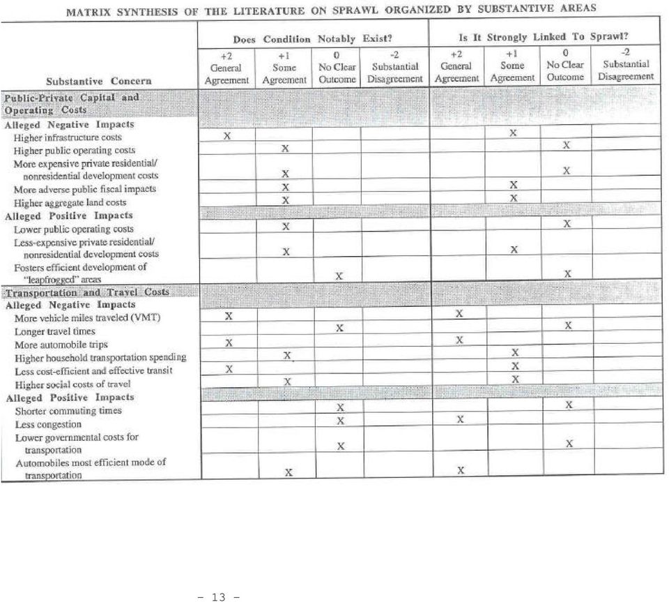
12 The following matrix drawn from the TCRP report organizes the conclusions drawn from literature on sprawl on the following five areas: - Public-Private Capital and Operating Costs - Transportation and Travel Costs - Land/Natural Habitat Preservation - Quality of Life - Social Issues The matrix shows whether the summarized literature agrees or disagrees with the alleged positive or negative impacts of sprawl. The two main questions addressed here are whether the alleged condition, for e.g. higher infrastructure costs, notably exists and whether it is strongly linked to sprawl. The matrix clearly shows that in the case of transportation related costs, there is a general agreement that there is an increase in the number of vehicle miles traveled (VMT) and auto trips and that these conditions are strongly related to sprawl. There is also some agreement that there is a higher household transportation spending and higher social costs of transportation and these are also related to sprawl
 and auto trips and that")
13 - 13 -
14 - 14 -

15 DOES TRANSPORTATION ACCELERATE SPRAWL? The general notion is that highways contribute to the growth of sprawl. While transportation may be one of the primary generators of sprawl, there are several other factors leading to the growth in low-density, scattered development in the urban fringes. These include population growth, increase in the number of households, employment growth, etc. However, one of the most important factors contributing to sprawldriven development is the American Dream or the desire to live on large lots in low-density, singlefamily neighborhoods. People are willing to pay higher costs for daily commute in order to afford a larger house in the suburbs. It is reasonable to say that transportation alone does not cause urban sprawl nut it definitely enables sprawl. Thus, stopping transportation projects alone will not contain sprawl. However, sound land use and transportation planning with effective policies and regulations that include transportation actions can greatly reduce the negative impacts of sprawl. APPROACHES TO CONTROL SPRAWL DRIVEN DEVELOPMENT Smart Growth and Growth Management Programs across the nation have been initiated as an active approach towards addressing the problem of sprawl. The two main functions of these programs are: To save our most valuable remaining natural resources before they are forever lost; To support existing communities and neighborhoods by targeting state resources to support development in areas where the infrastructure is already in place or planned to support it. 20 Smart Growth in Maryland Maryland, being one of the earliest contenders of a well-structured Smart Growth Program, is known for initiating and implementing one of the most effective programs of this kind in the country. The Smart Growth legislation in Maryland allows the State to direct its programs and funding to support locally designated growth areas and protect rural areas. 21 Known as Priority Funding Legislation, this legislation limits most State infrastructure funding and economic development, housing and other program monies to Smart Growth Areas. These Smart Growth areas are designated by the local government agencies. Counties may designate areas as Priority Funding Areas if they meet guidelines Loc. cit

16 for intended use, availability of plans for sewer and water systems, and permitted residential density. 22 Generally, those areas where industrial and other economic development is desirable are targeted as Priority Funding Areas. In addition, counties may designate areas planned for new residential communities, which will be served by water and sewer systems and meet density requirements. 23 As part of the Smart Growth Program, Maryland also initiated a Rural Legacy Program to protect undeveloped and valuable farmlands from further development. This Program reallocates State funds to purchase conservation easements for large contiguous tracts of agricultural, forest and natural areas subject to development pressure, and fee interests in open space where public access and use is needed. 24 Local governments and private land trusts are encouraged to identify Rural Legacy Areas and to competitively apply for funds to complement existing land conservation efforts or create new ones. 25 Maryland also passed a new Brownfields law, which limited the liability for developers redeveloping contaminated sites. In addition, the law created a voluntary clean-up program operated by the Maryland Department of the Environment (MDE) and established a Brownfields Revitalization Incentive Program to provide grants and low-interest loans to fund brownfields redevelopment. 26 Another highlight of the Smart Growth initiative in Maryland is their pilot Live Near Your Work program encouraging employees to buy homes near their workplaces. The intent of this program is to stabilize targeted neighborhoods. The local government administers this program and designates these targeted areas for the LNYW program. Homebuyers willing to move to these designated areas can receive a minimum of $3000 as an incentive. In addition, Maryland has also initiated a Job Creation Tax Credit Program that encourages mid-sized and smaller businesses to invest in these designated Smart Growth areas. This program promotes job creation by providing income tax credits to business owners who create at least 25 full-time, permanent jobs paying at least 150% of the minimum wage in Priority Funding Areas. 27 All of the above initiatives encourage urban infill and redevelopment thus helping to control sprawl in the process. One of the strengths of this program is the strong connection between the state and local Loc. cit Loc. cit

17 agencies in implementing this program within the state. As mentioned earlier, it is the responsibility of the local agencies to identify the growth areas and implement these programs. Thus, these programs that are designed at a state level can be tailored to meet the demands and needs of the local community. Growth Management in Portland, Oregon Growth Management in another effective approach adopted by several states in the country to control growth and channel it in a desired direction. Like the Smart Growth Program, it needs active coordination between the state and local government agencies for effective implementation. While the State DOTs usually support these programs by providing funding assistance, the local agencies need to take the initiative to implement this program. A good example where growth management has been effective is Oregon. The Transportation and Growth Management Program (TGM) in Portland Oregon was formed by the joint efforts of the Oregon Department of Transportation (ODOT) and the Department of Land Conservation and Development (DLCD) and is supported by state and federal funds under the provisions of the Intermodal Surface Transportation Efficiency Act of 1991 (ISTEA). The goal of this program is: To enhance Oregon's livability, foster integrated land use and transportation planning and encourage development that results in compact, pedestrian-, bicycle-, and transit-friendly communities. 28 This program has distributed $15.1 million as grant money to the local government to implement the following three objectives: 1. To help local governments develop transportation system plans and ordinances to implement the Transportation Planning Rule and the 1998 Oregon Highway Plan. 2. To help local governments to reconsider land use patterns to meet transportation needs by planning for compatible land uses along state highways to implement the 1998 Oregon Highway Plan. 3. To help local governments develop or implement plans that support an efficient and balanced transportation system. 29 To enhance Oregon's livability, foster integrated land use and transportation planning and encourage development that results in compact, pedestrian-, bicycle-, and transit-friendly communities Loc. cit

18 As part of this program, a Quick Response Team has been appointed to provide planning and design services to help developers and communities create compact, pedestrian-friendly, and livable neighborhoods and activity centers. 30 This team also provides the necessary technical assistance to the developers on financing options and alternative design strategies. The goal of this team is to encourage smart development, which includes supporting existing or infill developments with mixed use of spaces, multi-modal transportation options and the incorporation of human-scale design elements. This team also provides technical assistance to the local government agencies to modify their existing land use and transportation plans to meet the necessary codes in order to implement these smart development objectives. Moreover, they provide outreach programs, which include workshops to educate the public as well as the local planning commissions, city councils, etc. on the principles of smart development. Wisconsin s New Smart Growth Law In 1999, Wisconsin enacted its Smart Growth law, which was intended to provide local government units with the necessary tools to create comprehensive plans thus providing a framework for local land use decision making. The Smart Growth package requires the preparation of a comprehensive plan and that all programs and actions of the local government agencies that affect land use are consistent with this plan by January 1, The efforts of the local government agencies will be supported by state funded grant programs consisting of $2.5 million per year. This legislation also outlines 14 comprehensive planning goals to guide the actions of these local agencies. These planning goals are listed below: Promotion of the redevelopment of lands with existing infrastructure and public services and the maintenance and rehabilitation of existing residential, commercial and industrial structures; Encouragement of neighborhood designs that support a range of transportation choices; Protection of natural areas, including wetlands, wildlife habitats, lakes and woodlands, open spaces and groundwater resources; Protection of economically productive areas, including farmland and forests; Encouragement of land uses, densities and regulations that promote efficient development patterns and relatively low municipal, state government and utility costs; Preservation of cultural, historic, and archeological sites; Encouragement of coordination and cooperation among nearby units of government; 30 Loc. cit. 31 Summary and Guide to Wisconsin s Comprehensive Planning and Smart Growth Legislation (Draft). p

19 Building of community identity by revitalizing main streets and enforcing design standards; Providing an adequate infrastructure and public services and a supply of developable land to meet existing and future market demand for residential, commercial and industrial uses; Providing an adequate supply of affordable housing for all income levels throughout each community; Promoting the expansion or stabilization of the current economic base and the creation of a range of employment opportunities at he state, regional and local levels; Balancing individual property rights with community interests and goals; Planning and development of land uses that create or preserve varied and unique urban and rural communities; Providing an integrated, efficient, and economical transportation system that provides mobility, convenience and safety and which meets the needs of all citizens, including transit-dependent and disabled. The above goals show that the focus of this Smart Growth Law is on urban infill and redevelopment, provision of multi-modal choices to the public, protection of valuable natural, agricultural, historic and scenic lands, and increased interagency coordination. With the enactment of this law, there is pressure on the local government agencies to modify their comprehensive plans to incorporate these elements. This pro-active approach is the first step towards curbing uncontrolled growth. As in the case of Maryland, formal programs must be initiated at the state level to identify the priority or target areas within the state for redevelopment. However, these programs should be flexible so that they can be modified at the local level to meet the specific needs and demands of the area. The local government agencies will play an important role not only in identifying the boundaries of these target areas but also implementing these programs at the local level. The New Smart Growth Legislation requires the local government units to be proactive in their approach towards and land use and transportation decision-making. A Strategic Smart Growth Task Force in conjunction with the State Interagency Land Use Council may be appointed to direct the Smart Growth efforts at the local level and to increase coordination between the state and local agencies. The responsibilities of this Task Force will include: Providing the local government units the necessary technical support to study the growth characteristics and trends in their individual jurisdictions and identify priority funding areas for urban infill and redevelopment. Coordinating the land use activities between state agencies and local public and private interests

20 Providing the necessary assistance to local agencies to secure state-funded grants for implementing their Smart Growth efforts. Working with the local government agencies in actively involving the public in the planning process as well as educating them on various Smart Growth options. NEW APPROACHES TO DEVELOPMENT Several new approaches to development are being experimented and encouraged at the local level. Often, a package of development options needs to be implemented in combination with one another to protect important agricultural, natural, scenic and open land resources. These may be a combination of public, private and nonprofit tools, which may be tailored to the specific circumstances of a landowner, the type of development, and so on. The challenge is to define the appropriate package of tools to successfully protect special resource lands. 32 The techniques used may vary considerably based on the cost to the local jurisdiction, voluntary or regulatory nature, effectiveness, and the ability to permanently protect land. 33 A few of these approaches and cases where they have been successfully implemented at the local level are described below. Traditional Neighborhood Development (TND): The goal of this design approach is to create neighborhoods such those that existed in central cities prior to the mid-1950 s. Some of the design principles of TND s are: - Node base design - Grid street pattern with alleys and no cul-de-sacs - Multiple entry and exit points into the neighborhood - Mixed use development - A distinct architectural style with certain architectural specifications The drawback of this approach is that it may not necessarily be transit friendly. However, TND s generally encourage pedestrian activity on the streets with the provision of amenities within a walking distance. The examples shown here show the contrast of the neo-traditional approach versus a conventional residential subdivision. The neo-traditional example shows the mixed use of spaces with commercial activity being interspersed with the single family and multi-family housing thus 32 Menu of Land Protection Options: Wisconsin Farmaland Conservancy. 33 Loc. cit

21 encouraging higher pedestrian activity and lower dependency on the automobile. More information can be found on traditional neighborhood developments at the following web sites: Cluster Development: Cluster development is a residential site design and zoning technique used to protect natural, cultural or recreational features of the landscape while allowing new development. 34 This design approach aims at protecting more open space while still maintaining an average density on a parcel. The lot sizes for individual lots are made smaller so that more open space can be preserved in the natural state or used as permanent agricultural areas. Prairie Crossing, a conservation community in Lake County, Illinois, is a good example of a cluster-based subdivision. This subdivision is an example of how the cluster design can be used to lower the impact on natural landscape and minimize the cost of providing public services to the new development since homes are close together. When combined with comprehensive planning approaches that protect natural resources, cluster development can be effective in curbing sprawl. The following are a few web sites providing information on cluster developments and open space zoning: Purchase of Development Rights (PDR): PDR is primarily a farmland conservation program gaining recognition across the country. The intent of this program is to encourage orderly growth, curb development pressure on prime agricultural land, and help preserve green space around metropolitan areas. 35 The program is based on permanently restricting land s development rights by placing a conservation easement on the land. Usually, this easement is placed after a conservation agency or organization has purchased the development rights to the land. This program can have considerable 34 Memorandum to the Division Administrators, Bureau Directors, Regional Directors, Regional Media Leaders, from George E. Meyer on Cluster Development. 35 Farmland Preservation: Purchase of Development Rights. Distributed By Wisconsin Farm Bureau Federation
22 economic benefits for the farmer owning the land since it is based on an appraisal to determine the difference if the land value if it were developed and left undeveloped. This difference would be the development rights value. This money is given to the owner of the land, which can then be reinvested in the land if desired. The land could also only be sold as agricultural land (not at the development cost). States and counties usually modify PDR programs to suit their needs. For an effective approach to solving problems facing threatened farmlands, this program needs to be combined with other conservation programs or plans. A drawback of this program is funding, which is currently a problem with several states. Funding for programs of this nature is usually limited. A few strategies could be adopted to address this problem: - Set money aside for investment so that the interest on the money could be used for future funding of easements. - Have a time limit on the tax being appropriated for the PDR program, for e.g., 15 years. - Taking a portion of the land transfer tax or using the monies received when land is removed from the CAUV program. 36 It is important the specific people handling these programs at the local level have a good understanding of agriculture and the problems facing valuable farmlands. Inadequate knowledge of all the farmland related issues in general and specific to a scenario can lead to wastage of resources and inefficient administration. It is also very important to keep the public involved in such decisions. Active participation from the community and farmers is crucial to the success of such programs. Following are a few case studies that have successively implemented this program. The sources for these case studies are listed below: The Town of Dunn (Source: The Town of Dunn s Purchase of Development Rights (PDR) Program to Protect Farmland and Open Space, 4156 C.T.H. B McFarland, WI 53558): The Town of Dunn, located south of the City of Madison, Wisconsin, has 5,500 residents majority of who live along the shores of Lakes Waubesa and Kegonsa. Over 8,650 acres of the town are dedicated to agriculture, while an additional 2,600 acres as open space. Dunn prides itself in being the forefront of 36 Loc. cit
23 progressive, community-based land use policy. Being located south of fast growing city like Madison, Dunn needs to take proactive steps to control sprawl development and maintain a vital farming community. Between 1983 and 1990, this town lost 430 acres of its prime agricultural land. Dunn s borders are targets for annexation from quickly growing surrounding communities. In order to actively address this problem, there was a need to supplement the town s land use plan with other local programs to ensure long term growth management. In 1993, a committee consisting of local residents and members of the planning commission volunteered to explore other options for protecting open space and farmland. Purchase of Development Rights was seen as effective method to protect the land from future development. The main strengths of this program were that it was fair to the landowners and would remain effective even with changes in the future town leadership. In 1996, the residents of the town approved a property tax increase to fund a PDR program in the Town of Dunn. This would not have been possible without the broad-based support of the residents of this community. The tax increase amounted to $0.50, which would increase the tax on a $100,000 home by $50. In 1997, this program helped preserve a 240-acre farm with parcels in the City of Madison and the towns of Blooming Grove and Dunn, which was facing the threat of annexation by the City of Madison for development. The Green Corridor Project: Preserving Open Space in Washington and Chisago Counties, Minnesota, through Integrated Land Protection By Michael Pressman The Green Corridor Project is a multi-year collaborative program with the Land Stewardship Project s 1000 Friends of Minnesota program taking the lead. This program is based on voluntary, incentive-based tools to create a permanently protected green corridor in Washington and Chisago counties, Minnesota. Through this program, valuable lands protected through easements, environmentally sensitive areas, parks, open space, wildlife habitats and DNR S County Biological Survey sites will be permanently preserved. A total of 10,000 acres is designated as part of this corridor. The goal of this project is to provide the local government agencies and land preservation organizations the necessary tools, knowledge and incentives to protect the land designated as part of this corridor. The four primary tools used will be donated conservation easements, PDR, Transfer of Development Rights (TDR) and land acquisition. Each of these tools are briefly described below:
24 Donated Conservation Easements: This is a voluntary, legal agreement between a landowner and a land trust or government agency that restricts or prohibits the development of property. 37 Purchase of Development Rights (PDR), which has been explained in the section above. Transfer of Development Rights (TDR): This program consists of a unit of government such as the county, township, city or state establishing by ordinance a sending area, or preservation area, in which landowners receive development right credits which they can sell in exchange for not developing their land. 38 Land Acquisition: In these cases, the government agencies acquire fee title interest in land from willing landowners through donation or purchase, thus giving the agency full control over a property s future and management. 39 The first three tools are voluntary programs where the owners will still retain full ownership and control of their property. At the same time, the land is completely protected from further development. Land acquisition, on the other hand, also a voluntary tool, will be used wherever feasible on a willingbuyer/willing-seller basis. FUTURE OF THE LOCAL GOVERNMENT S ROLE IN LAND USE DECISION-MAKING In Wisconsin, enabling legislation gives the decision-making power pertaining to land use to local jurisdictions. 40 In a review by the Interagency Land Use Council done in December 1995 for Governor Tommy G. Thompson, several strengths and weaknesses of making land use and transportation decisions at the local level were discussed. These strengths and weaknesses are highlighted below: 37 Pressman, Michael. The Green Corridor Project Preserving Open Space in Washington and Chisago Counties through Integrated Land Protection. p Loc. cit. 39 Loc. cit. 40 Ibid., p
2010 Salida Community Priorities Survey Summary Results
 SURVEY BACKGROUND The 2010 Salida Community Priorities Survey was distributed in September in an effort to obtain feedback about the level of support for various priorities identified in the draft Comprehensive
Chapter 13: Implementation Plan
 Chapter 13: 13.1. INTRODUCTION The purpose of the implementation chapter of the Comprehensive Plan is to set forth the actions that the City will take to ensure that the plans, programs and policies set
Corridor Goals and Objectives
 Corridor Goals and Objectives This chapter presents the goals and objectives, developed by the Corridor Study Committee, that serve as the purpose and intent of the Corridor Plan. This plan covers a twenty
VANDERBILT COMPARISON
 Village of Vanderbilt Comparison One County, One Vision Master Plan (2000) 1 15 Improve recreation in Otsego County by assessing the availability and need to improve bike paths, county recreation facilities,
KANE COUNTY S PLANNING BENCHMARKS
 2030 Land Resource Management Plan PLANNING FRAMEWORK PLANNING IN KANE COUNTY (RPC 3/2/11) PLANNING IN KANE COUNTY Comprehensive planning has been a continuous function of Kane County government for over
Implementing Instructions - Sustainable Locations for Federal Facilities
 Implementing Instructions - Sustainable Locations for Federal Facilities Page 1 Background On October 5, 2009, President Obama signed Executive Order (E.O.) 13514, Federal Leadership in Environmental,
2. Inventory available public property within the site area. Include publiclyheld property, tax-foreclosures, and donated property.
 Land Assembly and Redevelopment What is it? Land is location, and location is the most valuable asset in successful real estate development. The right land transaction is crucial to each of the twin objectives
Chapter 9: Transportation
 Chapter 9: Transportation What is this chapter about? The goals and policies in this chapter convey the City s intent to: Create a coordinated, efficient, and more affordable multimodal transportation
Volume II Recommendations January 2006 City of Madison Comprehensive Plan
 2 LAND USE THE PLAN: GOALS, OBJECTIVES, POLICIES AND IMPLEMENTATION RECOMMENDATIONS Volume II Recommendations January 2006 TABLE OF CONTENTS Land Use Overview...2 1 Summary of Land Use Issues...2 2 Accommodating
Village of Spring Valley Comprehensive Plan 2009-2029
 Chapter 8: Intergovernmental Cooperation Introduction Intergovernmental communication, coordination, and cooperation can make a significant difference in the implementation and administration of a comprehensive
Permanently preserving privately owned productive agricultural land ensures a stable land base for the future of the agricultural industry.
 F A R M L A N D P R E S E R V A T I O N Permanently preserving privately owned productive agricultural land ensures a stable land base for the future of the agricultural industry. Farmland preservation,
Iowa Smart Planning. Legislative Guide March 2011
 Iowa Smart Planning Legislative Guide March 2011 Rebuild Iowa Office Wallace State Office Building 529 East 9 th St Des Moines, IA 50319 515-242-5004 www.rio.iowa.gov Iowa Smart Planning Legislation The
Attachment B Policy Audit Template
 Attachment B Policy Audit Template 5 6 7 8 9 0 Provide A Variety of Transportation Choices Provide A Variety of Transportation Choices Provide A Variety of Transportation Choices Encourage transit-oriented
Multifamily Housing: Sustainable Development in Efficient, Walkable Communities
 Multifamily Housing: Sustainable Development in Efficient, Walkable Communities by the Greater Charlotte Apartment Association Multifamily rental housing is a critical piece of the housing market in the
Near West Side Comprehensive Plan Executive Summary (Revised) April 2004 City of Milwaukee DCD
 April 2004 City of Milwaukee DCD") Near West Side Comprehensive Plan Executive Summary (Revised) April 2004 City of Milwaukee DCD Boundaries The Near West Side Comprehensive Plan covers a broad area immediately west of Milwaukee s downtown.
Near West Side Comprehensive Plan Executive Summary (Revised) April 2004 City of Milwaukee DCD Boundaries The Near West Side Comprehensive Plan covers a broad area immediately west of Milwaukee s downtown.
Restoration. a brief look at
 Copyright 2009 Canin Associates, Inc. All rights reserved. No part of this publication may be reproduced or transmitted by any means without written permission from Canin Associates, Inc. a brief look
IF THEN SURVEY RESULTS
 IF THEN SURVEY RESULTS BUILDING TOWARDS A REGIONAL VISION Survey Summary April 2013 BACKGROUND In the spring of 2011, the Piedmont Triad undertook an ambitious, 3-year planning effort designed to strengthen
Draft Goals and Objectives Wadena Comprehensive Plan City of Wadena, Minnesota. Land Use Goals:
 Draft Goals and Objectives Wadena Comprehensive Plan City of Wadena, Minnesota Land Use Goals: 1. Growth in Wadena will be undertaken in such a manner as to create a full range of living, working, shopping,
Smart Growth Illustrated: Developer s Guidebook. City of Bentonville Community Development Department October 2006
 Smart Growth Illustrated: Developer s Guidebook City of Bentonville Community Development Department October 2006 1 Table of Contents What is Smart Growth...3 Six Goals of Smart Growth 5 Ten Tools of Smart
Chapter 7 ZONING PLAN
 Chapter 7 ZONING PLAN Introduction This Chapter opens with a general description of a zoning plan. It is followed by a brief explanation of the relationship between this Growth Management Plan and the
Short-term. Action items that fall into this category need to take place over the next one to two years.
 Implementation Plan Building Momentum Through Incrementalism Queensbury s vision for its future, which emerged from public discussion over the past year, is as a vibrant regional center for living, working,
TRANSPORTATION SERVICE STANDARDS ELEMENT GOALS, OBJECTIVES & POLICIES
 TRANSPORTATION SERVICE STANDARDS ELEMENT GOALS, OBJECTIVES & POLICIES Background One of the most critical public services provided by a community is the community s transportation system. An effective
How To Improve Housing In Seminole County
 ELEMENT Introduction Issues and Concerns Goals, Objectives and Policies Exhibits 2020 ELEMENT INTRODUCTION Since populations group themselves into households, the socioeconomic makeup of those households
Appendix J Santa Monica Travel Demand Forecasting Model Trip Generation Rates
 Appendix J Santa Monica Travel Demand Forecasting Model Trip Generation Rates SANTA MONICA TRAVEL DEMAND FORECASTING MODEL TRIP GENERATION RATES SUBMITTED BY: 201 Santa Monica Blvd., Suite 500 Santa Monica,
Michigan State University Ingham County Health Department Tri- County Regional Planning Commission Land Use and Health Resource Team
 HEALTH IMPACT ASSESSMENT OF THE URBAN AND RURAL SERVICES MANAGEMENT POLICY Mid- Michigan Region Health In All Project Michigan State University Ingham County Health Department Tri- County Regional Planning
Cherokee County: Bells Ferry LCI Study & County Ordinance Audit. Prepared by Atlanta Regional Commission Staff 2006. Atlanta Regional Commission
 Cherokee County: Bells Ferry LCI Study & County Ordinance Audit Prepared by Atlanta Regional Commission Staff 2006 Atlanta Regional Commission 1 Document Review and Recommendations Introduction The objective
BASSETT CREEK VALLEY MASTER PLAN OPEN HOUSE
 BASSETT CREEK VALLEY MASTER PLAN OPEN HOUSE February 23, 2006 PROJECT INTRODUCTION Project Area 230 acres $50 million estimated market value (approximately) 50 acres parkland 100 residences (estimated)
Planning and Design for Sustainable Urban Mobility
 1 Planning and Design for Sustainable Urban Mobility 2 1 UrbanizationUrbanization Rapid pace, largely uncontrolled growth, taking place mainly in developing countries 3 Global Urbanization Trends World
MILWAUKEE. Plan. comprehensive DEPARTMENT OF CITY DEVELOPMENT MARCH, 2010 EXECUTIVE SUMMARY
 MILWAUKEE Plan DEPARTMENT OF CITY DEVELOPMENT MARCH, 2010 comprehensive CITYWIDE POLICY PLAN EXECUTIVE SUMMARY INTRODUCTION AND OVERVIEW I. OVERVIEW OF COMPREHENSIVE SMART GROWTH PLAN SERIES The series
Understanding Value Capture as a Transportation Finance Strategy in Massachusetts. March 15, 2013
 Understanding Value Capture as a Transportation Finance Strategy in Massachusetts March 15, 2013 Background The Massachusetts Legislature will soon explore options to increase transportation revenue. One
Sustainable city development through smart urban planning
 Sustainable city development through smart urban planning Agenda Summary Points Urban Planning Overview Urbanization in India Objectives of Smart Urban planning Key Focus Areas in Smart Urban Planning
COMPREHENSIVE PLAN HOUSING ELEMENT
 COMPREHENSIVE PLAN HOUSING ELEMENT Policy Document CHAPTER 3: HOUSING ELEMENT TABLE OF CONTENTS Chapter 3: HOUSING ELEMENT... 1 INTRODUCTION... 2 GOALS, OBJECTIVES AND POLICIES... 3 Goal: Housing... 3
IMPLEMENTATION STRATEGIES The following sections list the implementation strategies for following chapters.
 CHAPTER 13: IMPLEMENTATION INTRODUCTION The purpose of the Implementation Chapter is to set forth the actions that the City will take to ensure that the plans, programs, and policies set forth in the plan
2009-3. The Preservation of Local Truck Routes: A Primary Connection between Commerce and the Regional Freight Network
 2009-3 The Preservation of Local Truck Routes: A Primary Connection between Commerce and the Regional Freight Network July 2009 This Goods Movement Challenges and Opportunities Report was prepared jointly
KEYPORT COMMUNITY PLAN
 PLANNING COMMISSION TASKS Collect Public Comments on Draft Plan. Provide Clear Direction for: Preferred LAMIRD Boundary Lot Clustering Provision View Protection Recommendation to Board of County Commissioners.
Multimodal Transportation Planning at the State Level State of the Practice and Future Issues
 A1D01: Committee on Statewide Multimodal Transportation Planning Chairman: Neil J. Pedersen Multimodal Transportation Planning at the State Level State of the Practice and Future Issues NEIL J. PEDERSEN,
As stewards of the land, farmers must protect the quality of our environment and conserve the natural resources that sustain it by implementing
 N A T U R A L R E S O U R C E C O N S E R V A T I O N As stewards of the land, farmers must protect the quality of our environment and conserve the natural resources that sustain it by implementing conservation
What is Smart Growth and the New Urbanism??? Smart Growth and Sustainable Cities:
 Smart Growth and Sustainable Cities: 1) New Urbanism: Anti-car, Anti- Suburbia Planning for the US; 2) Sustainable Europe; 3) The New Asian City Dick G. Winchell, Ph.D., FAICP, Professor of Urban Planning,
Seattle Comprehensive Plan: Toward a Sustainable Seattle Evaluation
 Plan Analysis for UAP 5794 Sustainability Planning Lab Seattle Comprehensive Plan: Toward a Sustainable Seattle Evaluation Kaitlen Scanlon March 26, 2011 Table of Contents City Context Information... 2
Transportation Breakout Session. Curvie Hawkins Mark Rauscher Mike Sims Paul Moore
 Transportation Breakout Session Curvie Hawkins Mark Rauscher Mike Sims Paul Moore Curvie Hawkins Director of Planning Fort Worth Transportation Authority Fort Worth Transportation Authority The T Presented
Comprehensive Plan Amendment
 Staff Report CP-2-16 Comprehensive Plan Amendment Staff recommends four changes to the Economic Development element of the 2030 Comprehensive Plan to reflect a new Economic Development Toolkit and new
TAC CHARRETTE WORKBOOK Transportation and Air Quality
 For Discussion Purposes TAC CHARRETTE WORKBOOK Transportation and Air Quality NEW JERSEY HIGHLANDS COUNCIL March 28, 2006 1 Overview of RMP Goals and Structure NEW JERSEY HIGHLANDS COUNCIL 2 New Jersey
MEMORANDUM OF AGREEMENT Between THE CITY OF BALTIMORE And THE MID-ATLANTIC FEDERAL PARTNERSHIP FOR THE ENVIRONMENT
 MEMORANDUM OF AGREEMENT Between THE CITY OF BALTIMORE And THE MID-ATLANTIC FEDERAL PARTNERSHIP FOR THE ENVIRONMENT The Mid-Atlantic Federal Partnership for the Environment ( MAFPE ) and the City of Baltimore
TABLE OF CONTENTS. INTRODUCTION...1 Purpose of a Comprehensive Plan...1 McKenzie County Comprehensive Plan...1 Definitions...2 Goal...2 Vision...
 MCKENZIE COUNTY COMPREHENSIVE PLAN TABLE OF CONTENTS INTRODUCTION...1 Purpose of a Comprehensive Plan...1 McKenzie County Comprehensive Plan...1 Definitions...2 Goal....2 Vision...3 ECONOMIC DEVELOPMENT...4
 INTRODUCTION As part of a statewide realignment of due dates for updating local comprehensive plans, the Georgia Department of Community Affairs (DCA) is requiring partial updates as an interim step for
2015 -- H 6042 S T A T E O F R H O D E I S L A N D
 LC00 01 -- H 0 S T A T E O F R H O D E I S L A N D IN GENERAL ASSEMBLY JANUARY SESSION, A.D. 01 A N A C T RELATING TO TOWNS AND CITIES -- RHODE ISLAND COMPREHENSIVE PLANNING AND LAND USE ACT Introduced
Working farmland is a valuable and limited natural resource that once developed cannot be reclaimed for agricultural use.
 An excerpt from: Farmland Preservation in Maryland: Baltimore, Calvert, Charles and St. Mary s Counties Brian M. Hall with direction from Kate Clancy and Anne Palmer at the Center for a Livable Future,
INTRODUCTION TO ZONING DISTRICT REGULATIONS
 INTRODUCTION TO ZONING DISTRICT REGULATIONS Classification of Zoning Districts Zoning districts in Dorchester County are categorized as Suburban Urban, Suburban Transition, or Rural. These districts are
Appendix C Related Studies
 Appendix C Related Studies Intermodal Transit Village Concept Plan Appendix C Related Studies This appendix summarizes studies that are current at the time of this Plan. Intermodal Transit Village Concept
Public Worksessions - A Summary of the New York City Zoning and Planning Study
 APPENDIX F Third Public Work Session Notice Presentation July 27, 2004 For Immediate Release July 12, 2004 Town of Rotterdam Notice of Public Meeting The Town of Rotterdam Public Works Department will
Land Use and Zoning. Land Use Within the Port Madison Indian Reservation
 Land Use and Zoning Land Use Within the Port Madison Indian Reservation A portion of the Suquamish Rural Village is Trust land, owned either by the Tribe or individual tribal members. The following list
Federal Requirements for Statewide Transportation Plans
 Federal Requirements for Statewide Transportation Plans Title 23, U.S.C. 135 - Statewide and nonmetropolitan transportation planning (a) General Requirements. - (1) Development of plans and programs. -
APPLICABILITY OF LEED FOR COLLEGES AND UNIVERSITIES
 APPLICABILITY OF LEED FOR COLLEGES AND UNIVERSITIES Colleges and universities are prime candidates for many of the LEED rating systems. Stable institutions do well to plan for the long term. This involves
7.0 GOALS, OBJECTIVES & POLICIES
 7.0 GOALS, OBJECTIVES & POLICIES The following Goals, Objectives and Policies specific to Housing are organized into broad categories including: 7.1: Housing Availability 7.2: Protection of Existing Neighborhoods
Chapter 6 Economic Development Element
 Adopted, February 28, 2005 Durham Comprehensive Plan Chapter 6 Economic Development Element Durham City-County Planning Department Chapter 1. Chapter 2. Chapter 3. Chapter 4. Chapter 5. Chapter 6. Chapter
Section 5: Conserve to Enhance Program Goals What is Conserve to Enhance All About?
 Section 5: Conserve to Enhance Program Goals What is Conserve to Enhance All About? Conserve to Enhance (C2E) was originally conceptualized as an approach to giving the environment a seat at the table
Philadelphia County. Land Use and Growth Management Profile
 Philadelphia County is located in the southeastern corner of Pennsylvania and is bordered by the Pennsylvania counties of Delaware, Montgomery, and Bucks, and the New Jersey counties of Burlington, Camden,
Planning and Analysis Tools of Transportation Demand and Investment Development of Formal Transportation Planning Process
 Orf 467 Transportation Systems Analysis Fall 2015/16 Planning and Analysis Tools of Transportation Demand and Investment Development of Formal Transportation Planning Process 23 USC Para 134: Metropolitan
Southwest Light Rail Transit Minneapolis-St. Paul, Minnesota New Starts Project Development (Rating Assigned November 2014)
") Southwest Light Rail Transit Minneapolis-St. Paul, Minnesota New Starts Project Development (Rating Assigned November 2014) Summary Description Proposed Project: Light Rail Transit 15.7 Miles, 17 Stations
Southwest Light Rail Transit Minneapolis-St. Paul, Minnesota New Starts Project Development (Rating Assigned November 2014) Summary Description Proposed Project: Light Rail Transit 15.7 Miles, 17 Stations
New York s Industrial Access Program
 EXAMPLES OF INDUSTRIAL ROAD PROGRAMS NEW YORK'S INDUSTRIAL ROAD PROGRAM MISSISSIPPI'S ECONOMIC DEVELOPMENT HIGHWAY PROGRAM New York s Industrial Access Program New York s Industrial Access Program was
Performance Measures for a Sustainable Transportation Network Pasadena s Approach Frederick C. Dock, Ellen Greenberg, Mark Yamarone
 Performance Measures for a Sustainable Transportation Network Pasadena s Approach Frederick C. Dock, Ellen Greenberg, Mark Yamarone Abstract. As California cities move into the second decade of the 21st
Metropolitan Setting l
 Metropolitan Setting l GENERAL CHARACTERISTICS Los Angeles lies at the heart of one of the most complex metropolitan regions in the United States. As a major center of commerce, finance, and industry in
Infrastructure & Growth Leadership Pillar Strategy Statements from Existing Plans Developing Florida s Strategic 5-Year Direction, 29 November 2011
 Infrastructure & Growth Leadership Pillar Strategy Statements from Existing Plans Developing Florida s Strategic 5-Year Direction, 29 November 2011 Key Themes Global trade infrastructure seaports, airports,
Frederick. Frederick. Maryland. Smart Growth Successes. Frederick. Maryland Department of Planning
 Frederick Frederick Maryland Smart Growth Successes Frederick Maryland Department of Planning Smart, Green & Growing Martin O Malley Governor Anthony G. Brown Lt. Governor Maryland Department of Planning
Wisconsin Land Trusts
 Wisconsin Land Trusts What is a Land Trust? Conservation land is essential to the health and beauty of Wisconsin. Land trusts are non-profit organizations that help protect land for public benefit. There
Market-Based Planning Tools: An Overview of TDRs and PDRs
 Market-Based Planning Tools: An Overview of TDRs and PDRs Kevin Cheshire, Research Fellow, Coastal Resources, Law, Planning and Policy Center February 12, 2007 1 Introduction Planners and local governments
Atlanta Regional Commission s Lifelong Communities Initiative: Creating Communities for All Ages and Abilities
 Atlanta Regional Commission s Lifelong Communities Initiative: Creating Communities for All Ages and Abilities Laura Keyes, MS, AICP and Cathie Berger, LMSW The Atlanta region is experiencing a monumental
I I I I I I. 8. Encourage equitable taxation and assessment policies for
 6. Encourage the establishment of appropriate Agriculture Security Areas, under Act 43, as amended, consistent with local and county Comprehensive Plans. Care should be taken not to designate farmland
6 REGIONAL COMMUTE PATTERNS
 6 REGIONAL COMMUTE PATTERNS INTRODUCTION One of the challenges for this study, which has a primary goal of looking at commute opportunities in MnDOT District 3, is that in some portions of the study area,
and 7 Queensland Transport, Moving People Connecting Communities: A Passenger Transport Strategy for Queensland 2007 2017, 2006
 and 7 Key result area 1 Shaping the future Developing new products and services, planning and behavioural change 1. Change behaviour to encourage sustainable transport choices To develop an awareness of
Kirkland Zoning Code 113.25
 Kirkland Zoning Code 113.25 Chapter 113 COTTAGE, CARRIAGE AND TWO/THREE-UNIT HOMES Sections: 113.05 User Guide 113.10 Voluntary Provisions and Intent 113.15 Housing Types Defined 113.20 Applicable Use
Green Growth Platform questionnaire Answers submitted by Rahm Emanuel. Chicago s Climate Change Solutions and Clean Energy Future
 Green Growth Platform questionnaire Answers submitted by Rahm Emanuel Chicago s Climate Change Solutions and Clean Energy Future 1. Fisk and Crawford Coal Plants -- Clean Up or Shut Down: Will you strongly
RE-BUILDING BETTER NEIGHBORHOODS (R-BBN) & SINGLE-FAMILY HOUSING REHABILITATION PROGRAMS PROGRAM INFORMATION AND CONTACTS
 & SINGLE-FAMILY HOUSING REHABILITATION PROGRAMS PROGRAM INFORMATION AND CONTACTS") RE-BUILDING BETTER NEIGHBORHOODS (R-BBN) & SINGLE-FAMILY HOUSING REHABILITATION PROGRAMS Mission PROGRAM INFORMATION AND CONTACTS Greater Minnesota Housing Fund invests in affordable housing and sustainable
RE-BUILDING BETTER NEIGHBORHOODS (R-BBN) & SINGLE-FAMILY HOUSING REHABILITATION PROGRAMS Mission PROGRAM INFORMATION AND CONTACTS Greater Minnesota Housing Fund invests in affordable housing and sustainable
Model Subdivision and Land Development (SALDO) Subdivision/ Land Development Presentation Overview. Why Subdivision and Land Development Regulations?
 Subdivision/ Land Development Presentation Overview. Why Subdivision and Land Development Regulations?") Model Subdivision and Land Development (SALDO) Subdivision/ Land Development Presentation Overview Purpose of Subdivision/ Land Development Ordinances (SALDO) Municipalities Planning Code Process Design
Model Subdivision and Land Development (SALDO) Subdivision/ Land Development Presentation Overview Purpose of Subdivision/ Land Development Ordinances (SALDO) Municipalities Planning Code Process Design
SECTION ONE CHAPTER 2: A LAND USE PROFILE OF MANCHESTER
 SECTION ONE CHAPTER 2: A LAND USE PROFILE OF MANCHESTER Land use is the central element of a comprehensive plan because it establishes the overall physical configuration of the city, including the mix
Note: The following are informal notes based on information received during this public meeting.
 Town of Colonie, New York Housing and Neighborhoods Focus Group Meeting Notes October 7, 2004 The Crossings at Colonie T H E S A R A T O G A A S S O C I A T E S LANDSCAPE ARCHITECTS, ARCHITECTS, ENGINEERS,
1 2 3 4 Appendix A Appendix B Appendix C
 1 2 3 4 Appendix A Appendix B Appendix C Introduction This chapter provides the foundation for the Comprehensive Plan, outlining why we plan, the planning process, Smart Growth Planning, and the planning
Zoning Districts, Gwinnett County, Georgia
 Zoning Districts, Gwinnett County, Georgia The zoning district descriptions in this section should be used as a guide only for the unincorporated areas of Gwinnett County. Before buying or selling property,
FINAL DRAFT FINAL DRAFT
 MovingDutchess2 Figure3 1.DutchessCounty withintheregion Chapter3 RegionalPerspective DutchessCountyislocatedatthecenteroftheHudsonValley, halfwaybetweennewyorkcityandalbany.itisatthe northernreachesofnewyorkcitycommutingdistance,yet
INFRASTRUCTURE COSTS, BROWNFIELDS VS. GREENFIELDS
 INFRASTRUCTURE COSTS, BROWNFIELDS VS. GREENFIELDS EXCERPT, ANALYSIS OF THE ECONOMIC, FISCAL, AND ENVIRONMENTAL IMPACTS OF THE MASSACHUSETTS BROWNFIELDS TAX CREDIT PROGRAM, EVANS PAULL, REDEVELOPMENT ECONOMICS,
How To Improve Service In Arundel
 Draft of Economic Development Strategy - Town of Arundel Chapter 3.3 - Infrastructure, Transportation and Zoning 1. Infrastructure The lack of infrastructure in Arundel could present significant problems
administrative subdivisions of the counties and are not counted as separate governments in census statistics on governments. IOWA
 IOWA Iowa ranks 17th among the states in number of local governments with 1,954 as of October 2007. COUNTY GOVERNMENTS (99) There are no areas in Iowa lacking county government. The county governing body
Factors Affecting Residential Property Development Patterns
 Factors Affecting Residential Property Development Patterns Authors Greg T. Smersh, Marc T. Smith and Arthur L. Schwartz Jr. Abstract This article is the winner of the Real Estate Development manuscript
Positions on Issues. League of Women Voters of San Diego County
 Positions on Issues League of Women Voters of San Diego County INTRODUCTION LWV of San Diego County has taken the following positions after study, member education and consensus. LWV can take action on
How To Amend A Stormwater Ordinance
 Regulatory Alternatives to Address Stormwater Management and Flooding in the Marlboro Street Study Area Alternative 1: Amend Existing Local Regulations This proposed alternative provides an incremental
Conservation Tax Credit Regulations Chapter 391-1-6 A-1 RULES OF GEORGIA DEPARTMENT OF NATURAL RESOURCES CHAPTER 391-1-6
 Conservation Tax Credit Regulations Chapter 391-1-6 A-1 RULES OF GEORGIA DEPARTMENT OF NATURAL RESOURCES CHAPTER 391-1-6 GEORGIA CONSERVATION TAX CREDIT PROGRAM TABLE OF CONTENTS 391-1-6-.01 Purpose and
Rural Residential Buildable Lands Inventory
 The Dalles Periodic Review, May 2013 Rural Residential Lands Inventory Contents Introduction and Summary... 1 Concerns related to the 2007 Analysis... 2 Rural Residential Capacity Summary... 2 Methodology...
ECONOMIC DEVELOPMENT. in this chapter. 8.1 Overview of Economic Conditions. 8.2 Priority Economic Development Needs
 8 ECONOMIC DEVELOPMENT in this chapter 8.1 Overview of Economic Conditions 8.2 Priority Economic Development Needs 8.3 Economic Development Goals and Policies chapter 8 economic development Creating new
TRAVEL BEHAVIOR ISSUES RELATED TO NEO-TRADITIONAL DEVELOPMENTS A REVIEW OF THE RESEARCH
 TRAVEL BEHAVIOR ISSUES RELATED TO NEO-TRADITIONAL DEVELOPMENTS A REVIEW OF THE RESEARCH SUSAN HANDY University of Texas School of Architecture Goldsmith Hall Austin, TX 78712-1160 At first glance, it may
Appendix E Transportation System and Demand Management Programs, and Emerging Technologies
 Appendix E Transportation System and Demand Management Programs, and Emerging Technologies Appendix Contents Transportation System Management Program Transportation Demand Management Program Regional Parking
13. ENVIRONMENTAL PROTECTION/ RESOURCE MANAGEMENT
 13. ENVIRONMENTAL PROTECTION/ RESOURCE MANAGEMENT A. Existing Conditions Ramsey is fortunate to have an ample amount of natural resources and open space areas and a community attitude that is increasingly
Much Ado About Kelo: Eminent Domain and Farmland Protection
 Much Ado About Kelo: Eminent Domain and Farmland Protection December 2005 In the case of Kelo v. the City of New London, the Supreme Court ruled that the Connecticut city could acquire land by eminent
Market Analysis for Padre Boulevard Initiative in the Town of South Padre Island, TX
 Market Analysis for Padre Boulevard Initiative in the Town of South Padre Island, TX Prepared for Gateway Planning Group Spring 2010 TXP, Inc. 1310 South 1st Street; Suite 105 Austin, Texas 78704 (512)
Sustainability and Livability Summary of Definitions, Goals, Objectives and Performance Indicators 11 March 2011
 www.vtpi.org Info@vtpi.org Phone & Fax: 250-360-1560 Sustainability and Livability Summary of Definitions, Goals, Objectives and Performance Indicators 11 March 2011 Todd Litman Written in cooperation
State Environmental Trust Funds
 INFORMATION BRIEF Minnesota House of Representatives Research Department 600 State Office Building St. Paul, MN 55155 John Helland, Legislative Analyst 651-296-5039 December 2005 State Environmental Trust
His Worship Jim Watson Mayor of the City of Ottawa 110 Laurier Avenue West Ottawa, Ontario K1P 1J1 Dear Mr. Mayor,
 His Worship Jim Watson Mayor of the City of Ottawa 110 Laurier Avenue West Ottawa, Ontario K1P 1J1 Dear Mr. Mayor, Thank you for writing regarding the Green Party s position on issues of interest to the
01/31/13 ACHIEVING THE VISION FOR RESTON. Reston Master Plan Special Study Task Force
 ACHIEVING THE VISION FOR RESTON Reston Master Plan Special Study Task Force The Reston Master Plan Special Study Task Force was appointed by Hunter Mill District Supervisor Catherine Hudgins to review
NYCIDA PROJECT COST/BENEFIT ANALYSIS June 5, 2014
 NYCIDA PROJECT COST/BENEFIT ANALYSIS June 5, 2014 APPLICANT Skyline Restoration Inc. CGI Northeast, Inc. Spring Scaffolding LLC Metropolitan Northeast LLC 11-20 37 th Avenue Long Island City, NY 11101
5 Performance Measures
 5 Performance Measures This page left blank intentionally. 5 2 Moving Forward Monterey Bay 2035 Introduction The investments identified in the 2035 MTP/SCS are expected to result in significant benefits
VISION, DESIGN PRINCIPLES & OVERALL PLANNING STRATEGY
 3 VISION, DESIGN PRINCIPLES & OVERALL PLANNING STRATEGY The overall planning strategy for the Bank Street CDP is to ensure that future development is undertaken in a coordinated and planned approach, supported