TAC CHARRETTE WORKBOOK Transportation and Air Quality
|
|
|
- Walter Johns
- 8 years ago
- Views:
Transcription
1 For Discussion Purposes TAC CHARRETTE WORKBOOK Transportation and Air Quality NEW JERSEY HIGHLANDS COUNCIL March 28,

2 Overview of RMP Goals and Structure NEW JERSEY HIGHLANDS COUNCIL 2

3 New Jersey Highlands Goals of the Act Protect and conserve the quality and quantity of drinking water Protect natural, scenic, recreational, cultural and historic resources Preserve contiguous lands in their natural state Preserve farmland and farming Promote appropriate patterns of development, redevelopment and economic growth Promote a sound and balanced transportation system 3

4 Highlands Regional Master Plan I.Policy Guidance Document II. Technical Documentation III. Implementation Framework Resource Assessment Smart Growth Transportation Consistency Local Participation Financial Water Resource Management Ecosystem Management Agriculture and Forestry Land Preservation Historic and Scenic Resources Regional Development and Design TDR Guidelines Utility Capacity Transportation/Air Quality Financial Analysis Land Capability Map Conformance Process Resource Protection Standards Regional Growth Standards Adjustments/Revisions 4

5 Highlands Regional Master Plan I.Policy Guidance Document II. Technical Documentation III. Implementation Framework A statement of the goals, policies, strategies and public participation necessary to develop the RMP and implement the Act The technical basis supporting the policies and standards, explains science and technical analyses supporting the RMP The Land Use Capability Map, including district overlay zones and other tools for RMP conformance and implementation 5

6 Highlands Regional Master Plan 6

7 Transportation and Air Quality Requirements of the Act NEW JERSEY HIGHLANDS COUNCIL 7

8 Transportation and Air Quality Requirements of the Act Transportation Component: Provide a plan for transportation system preservation... include projects to promote a sound, balanced transportation system that is consistent with smart growth strategies and principles and which preserves mobility and maintains the transportation infrastructure of the Highlands Region. Highlands Act, Section 11, N.J.S.A. 13:20-11.a(5) An assessment to based upon the resource assessment of opportunities for appropriate development, redevelopment, and economic growth, including public investment priorities, infrastructure investments, economic development, revitalization, housing, transportation including transit villages In the planning area the assessment shall identify infrastructure that would support or limit development or redevelopment... Highlands Act, N.J.S.A. 13:20-11.a (6) 8
 An assessment to based upon the resource assessment of opportunities for appropriate development, redevelopment, and economic growth, including public investment priorities, infrastructure")
9 Transportation and Air Quality Requirements of the Act (continued) Determine the amount and type of human development and activity which the ecosystem of the Highlands Region can sustain while still maintaining the overall ecological values thereof, with special reference to:.air quality; and other appropriate considerations affecting the ecological integrity of the Highlands Region Highlands Act, N.J.S.A. 13:20-11.a(1)(a) The council shall also consult with the Department of Transportation in preparing the transportation component of the regional master plan. Highlands Act, N.J.S.A. 13:20-9.a. 9
(a) The council shall also consult with the Department of Transportation in preparing the transportation component of the regional master plan.")
10 Technical Approach and Methods Transportation and Air Quality NEW JERSEY HIGHLANDS COUNCIL 10

11 Transportation and Air Quality Program Objectives Describe the current condition and existing capacity of transportation in the Highlands Evaluate the extent to which existing and future human populations be served without further impairing air quality Develop transportation strategies that are most beneficial in creating sustainable growth and a reliable transportation system 11

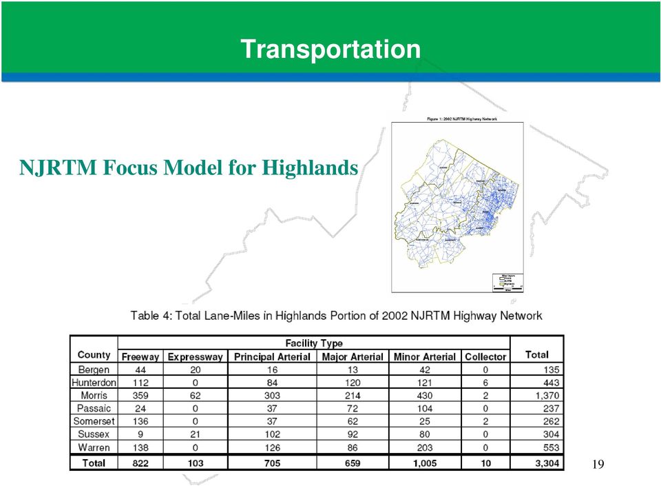
12 Transportation and Air Quality Data Sources Transportation Assessment North Jersey Regional Transportation Model - Focus Model for Highlands Traffic Counts Geographic Information System Mapping Historical Patterns Research on Air Quality and Transportation Issues Transportation Assessment Existing Conditions Results of Highlands Focus Model New Jersey Transit data New Jersey Dept. of Transportation data North Jersey Transportation Planning Authority (NJTPA) data 12

13 Transportation and Air Quality Data Sources Air Quality Assessment NJ Dept. of Environmental Protection Environmental Protection Agency NJTPA Conformity analysis Focus model air quality analysis 13

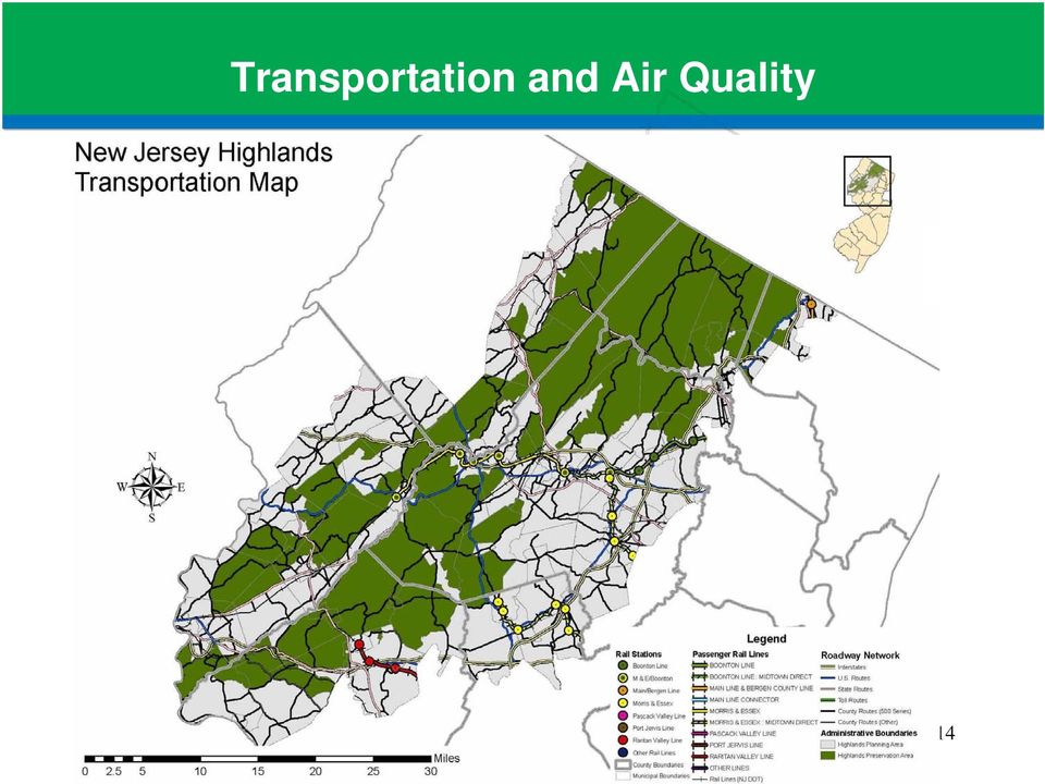
14 Transportation and Air Quality 14
15 Transportation Technical Approach Transportation System Capacity Assessment Use North Jersey Regional Transportation Model (NJRTM) to create Focus Model for Highlands (Base 2002 Year only): Objectives:» identify existing NJRTM road and transit network and capacities;» Identify roadways that cannot sustain additional vehicular growth Determine geographic focus area Collect data from regional and county models Collect and validate traffic counts Create and validate socioeconomic data Validate and run model Receive and Review Results 15

16 Transportation Technical Approach Transportation System Capacity Assessment (continued) Data Gaps Additional traffic count and detailed socioeconomic data Better road network and more detailed Traffic Analysis Zone (TAZ) structure 16
")
17 Transportation Technical Approach Transportation System Preservation and Sustainability Develop a transportation element that identifies improvements based on capacity and other analyses, interagency coordination, local input and sustainable transportation practices Research Inform and Refine Approach: - Sustainable Transportation Strategies - Air Quality, Land Use and Transportation Planning connections - Sprawl Impacts on Transportation Sprawl Attribute Transportation Impacts Density Reduces density. Requires more land for roads and parking facilities. Greenfield development Allows urban fringe, greenfield development. Dispersion Allows more dispersed destinations. Mix Allows single-use development. Scale Requires large-scale roads and blocks. Street design Roads emphasize vehicle traffic flow, de-emphasize pedestrian activities. Transportation options Degrades walkability, reducing pedestrian and transit accessibility. Source:Online TDM Encyclopedi, Victoria Policy Transport Institute, 2006 Encourage community-developed local circulation planning Identify potential transportation improvements & capital investment strategies in support of projects, funding and programs which promote smart growth & fit above framework 17

18 Transportation NJRTM Focus Model for Highlands Data Gaps: Better road network to provide comprehensive understanding of regional travel More traffic counts to ensure valid results Future Scenarios analyses and comparison 18

19 Transportation NJRTM Focus Model for Highlands 19
20 Transportation NJRTM Focus Model for Highlands Data Gaps: Future socioeconomic data More detailed socioeconomic data for model refinement 20

21 Transportation NJRTM Focus Model for Highlands Transportation Capacity 2002 Identifies worst capacity per link for morning and evening rush hours Red = at or near capacity Yellow = approaching capacity Green = capacity not constrained AM Peak Period PM Peak Period 21
22 Air Quality Technical Approach Consider air quality in the development of plans and programs for the Highlands Consider how the built environment and it s geographical arrangements impact the quality and quantity of air pollutants, how industry emissions from other locales may travel and affect human health, and how and by what mode people and goods are transported which affects the amounts of pollutants emitted from traffic. Promote a transportation system for the Highlands Region that is protective of the regional air quality. Develop a process for interagency coordination that is supportive of regional air quality initiatives. 22
23 Problem Statements Transportation and Air Quality NEW JERSEY HIGHLANDS COUNCIL 23
24 Transportation and Air Quality Problem Statement #1 In light of identifying where existing infrastructure is at capacity, where is additional traffic growth most appropriate? And what roadways cannot sustain additional vehicular growth? Potential Approach: Identify corridors or growth areas for further evaluation Data Gaps Additional Traffic Analysis Zone definition to model more Highlands roads many not in NJRTM Limited traffic count data Corridor specific analyses Community: land use- transportation analyses once growth areas determined Transportation analysis of future trend and build scenarios 24
25 Transportation and Air Quality Problem Statement #2 How do we best integrate land use and transportation planning to minimize impacts on the transportation system? Potential Approach: Sustainable Transportation Strategies Air Quality, Land Use and Transportation Planning connections Sprawl Impacts on Transportation Sprawl Attribute Transportation Impacts Density Reduces density. Requires more land for roads and parking facilities. Greenfield development Allows urban fringe, greenfield development. Dispersion Allows more dispersed destinations. Mix Allows single-use development. Scale Requires large-scale roads and blocks. Street design Roads emphasize vehicle traffic flow, de-emphasize pedestrian activities. Transportation options Degrades walkability, reducing pedestrian and transit accessibility. Source:Online TDM Encyclopedi, Victoria Policy Transport Institute,
26 Transportation and Air Quality Data Gaps Community-developed local circulation planning in coordination with Highlands RMP Smart growth design principles Local pedestrian and bicycle plans Potential transportation improvements & capital investment strategies which promote smart growth & fit above framework Identify missing roadway links 26
27 Transportation and Air Quality Problem Statement #3 For growth areas to be the most efficient, what land planning and transportation techniques could be incorporated to maximize multi-modal transportation opportunities? Potential Approach: Establish criteria for design guidelines which encourage multimodal and non-motorized travel Data Gaps Research and evaluation of design guidelines for Transit Oriented Developments in environmentally sensitive locations Quantification of changes in selected criteria such as vehicle miles traveled, mode choice, etc 27
28 Transportation and Air Quality Problem Statement #4 In consideration of the uniqueness of Highlands area natural resources, what is the best way to coordinate regional and statewide transportation planning strategy decision-making amongst the various agencies and technical experts? Potential Approaches: Protect capacity, minor physical improvements that aid capacity and improve safety; system maintenance; Intelligent Transportation Systems; incident management; access management; travel demand management Road ecology Data Gaps Detailed analysis/application of appropriate strategies to regional (NJRTM) and local major roads in light of Highlands sensitivities 28
29 Transportation and Air Quality Problem Statement #5 What are the key air quality issues related to transportation that affect the Highlands Region? What are the key stationary source issues that affect the Highlands Region? What measures or strategies could be employed to have the least negative impact on air quality? Potential Approach: How should interagency coordination best be facilitated to support addressing this issue? Data Gaps Current analysis of road network useful largely for comparison of alternate scenarios for transportation system only (not stationary sources) awaiting completion of build out model process to proceed Not a hot spot analysis Stationary source data 29
Attachment B Policy Audit Template
 Attachment B Policy Audit Template 5 6 7 8 9 0 Provide A Variety of Transportation Choices Provide A Variety of Transportation Choices Provide A Variety of Transportation Choices Encourage transit-oriented
Chapter 9: Transportation
 Chapter 9: Transportation What is this chapter about? The goals and policies in this chapter convey the City s intent to: Create a coordinated, efficient, and more affordable multimodal transportation
HOW WILL PROGRESS BE MONITORED? POLICY AREA. 1. Implement the 2040 Growth Concept and local adopted land use and transportation plans
 PERFORMANCE MONITORING APPROACH OAR 660-044-0040(3)(e) directs Metro to identify performance measures and targets to monitor and guide implementation of the Climate Smart Strategy. The purpose of performance
S.B. NO. B7b JAN 2 7 2016
 S.B. NO. Bb JAN 0 A BILL FOR AN ACT THE SENATE TWENTY-EIGHTH LEGISLATURE, 0 STATE OF HAWAII RELATING TO STATEWIDE COMMUNITY PLAN. BE IT ENACTED BY THE LEGISLATURE OF THE STATE OF HAWAII: SECTION. The legislature
Corridor Goals and Objectives
 Corridor Goals and Objectives This chapter presents the goals and objectives, developed by the Corridor Study Committee, that serve as the purpose and intent of the Corridor Plan. This plan covers a twenty
The Northwest Arkansas Travel Demand Model
 The Northwest Arkansas Travel Demand Model Creation and Results John McLarty Northwest Arkansas Regional Planning Commission Cristina Scarlat Center for Advanced Spatial Technologies What is a Travel Demand
Citizen Advisory Group Meeting #1 December 8, 2011 6:00 p.m.
 Citizen Advisory Group Meeting #1 December 8, 2011 6:00 p.m. Meeting Agenda 1. Background Information 2. Policy Framework 3. Plan Development Process 4. Public Input Results 5. Vision Statement 6. Group
2010 Salida Community Priorities Survey Summary Results
 SURVEY BACKGROUND The 2010 Salida Community Priorities Survey was distributed in September in an effort to obtain feedback about the level of support for various priorities identified in the draft Comprehensive
VANDERBILT COMPARISON
 Village of Vanderbilt Comparison One County, One Vision Master Plan (2000) 1 15 Improve recreation in Otsego County by assessing the availability and need to improve bike paths, county recreation facilities,
KANE COUNTY S PLANNING BENCHMARKS
 2030 Land Resource Management Plan PLANNING FRAMEWORK PLANNING IN KANE COUNTY (RPC 3/2/11) PLANNING IN KANE COUNTY Comprehensive planning has been a continuous function of Kane County government for over
Summary Community Workshop #2 Fruitvale San Antonio Senior Center. Wednesday, April 22, 2009 7:00-9:00 p.m.
 Summary Community Workshop #2 Wednesday, April 22, 2009 7:00-9:00 p.m. Workshop Format and Process The City of Oakland is preparing a Specific Plan that will help define and determine a common vision for
I-90 ALLSTON INTERCHANGE PLACEMAKING STUDY Boston Redevelopment Authority
 I-90 ALLSTON INTERCHANGE PLACEMAKING STUDY Boston Redevelopment Authority The Cecil Group Stantec Nelson/Nygaard Task Force Presentation December 17, 2015 I-90 Allston Interchange Placemaking Study Agenda
Appendix J Santa Monica Travel Demand Forecasting Model Trip Generation Rates
 Appendix J Santa Monica Travel Demand Forecasting Model Trip Generation Rates SANTA MONICA TRAVEL DEMAND FORECASTING MODEL TRIP GENERATION RATES SUBMITTED BY: 201 Santa Monica Blvd., Suite 500 Santa Monica,
Draft Non Transportation Performance Measures Including Related Qualitative Assessment of Example Sections
 Draft Non Transportation Performance Measures Including Related Qualitative Assessment of Example Sections Phil Erickson Community Design + Architecture Mike Johnson HDR Engineering CTF Charrette Approach
How To Plan A City Of Mason
 Transportation Master Plan (TMP) for the City of Madison: Draft Scope of Work Briefing for Madison Area TPB/MPO June 6, 2012 TMP: Overview/Purpose Help Create Walkable, Bikeable, Livable City - Strengthen
City of North Miami Beach, Florida Planning and Zoning Department
 City of North Miami Beach, Florida Planning and Zoning Department City Council Staff Report TO: FROM: City Council Carlos Rivero, City Planner DATE: March 17, 2015 ITEM: 14-021B (Ordinance no. 2015-5)
Restoration. a brief look at
 Copyright 2009 Canin Associates, Inc. All rights reserved. No part of this publication may be reproduced or transmitted by any means without written permission from Canin Associates, Inc. a brief look
Comprehensive Plan Policies that support Infill and Mixed Use
 Comprehensive Plan Policies that support Infill and Mixed Use Introduction A comprehensive plan provides a broad vision for the future growth of a community. It is often formulated using community visioning
Iowa Smart Planning. Legislative Guide March 2011
 Iowa Smart Planning Legislative Guide March 2011 Rebuild Iowa Office Wallace State Office Building 529 East 9 th St Des Moines, IA 50319 515-242-5004 www.rio.iowa.gov Iowa Smart Planning Legislation The
A Bicycle Accident Study Using GIS Mapping and Analysis
 A Bicycle Accident Study Using GIS Mapping and Analysis Petra Staats, Graduate Assistant, Transportation Policy Institute, Rutgers University, New Brunswick, NJ, USA pstaats@eden.rutgers.edu Summary Surveys
XI. Historic Element. Historic Element. Borough of Riverdale Master Plan
 Historic Element XI. Historic Element A place where those who live here want to stay and those who don t wish they did XI-1 Historic Element XI. Historic Element 1.0 INTRODUCTION In an effort to complement
Community Development Overview
 Community Development Overview Citizen s Planning Academy Presented on March 2, 2016 Planning/Smart Growth Overview Brief History of Planning/Urban Form Smart Growth SACOG Blueprint General Plan Update
2
 1 2 3 4 5 6 7 8 9 Source: U.S. Census and Iowa Data Center 10 Source: U.S. Census and Iowa Data Center 11 Source: U.S. Census, Iowa Data Center, Upper Explorerland RPC (projection calculation 12 Source:
Borough of Glassboro, New Jersey May 2010. Redevelopment Plan for Rehabilitation In the Borough of Glassboro May 2010
 Borough of Glassboro, New Jersey May 2010 Redevelopment Plan for Rehabilitation In the Borough of Glassboro May 2010 Table of Contents Page Number I. Introduction 3 II. Designation of Area and Plan Development
28.0 Development Permit Area #2 (Neighbourhood District)
") 28.0 Development Permit Area #2 (Neighbourhood District) Goals and Objectives To provide a guide for infill and new development in the Neighbourhood District. To outline the nature, form and character
28.0 Development Permit Area #2 (Neighbourhood District) Goals and Objectives To provide a guide for infill and new development in the Neighbourhood District. To outline the nature, form and character
Implementing Instructions - Sustainable Locations for Federal Facilities
 Implementing Instructions - Sustainable Locations for Federal Facilities Page 1 Background On October 5, 2009, President Obama signed Executive Order (E.O.) 13514, Federal Leadership in Environmental,
Tier 1 Strategies. WV Route 14 Corridor Management Plan
 1.1 1.2 1.3 1.4 Signal timing optimization system improvements. Improve geometry traffic control at high crash intersections. Construct intersection capacity improvement projects. Widen longer sections
Sustainable urban mobility: visions beyond Europe. Brest. Udo Mbeche, UN-Habitat
 Sustainable urban mobility: visions beyond Europe 2 nd October 2013 Brest Udo Mbeche, UN-Habitat The Global Report for Human Settlements Published every two years under a UN General Assembly mandate. Aims
IF THEN SURVEY RESULTS
 IF THEN SURVEY RESULTS BUILDING TOWARDS A REGIONAL VISION Survey Summary April 2013 BACKGROUND In the spring of 2011, the Piedmont Triad undertook an ambitious, 3-year planning effort designed to strengthen
Short-term. Action items that fall into this category need to take place over the next one to two years.
 Implementation Plan Building Momentum Through Incrementalism Queensbury s vision for its future, which emerged from public discussion over the past year, is as a vibrant regional center for living, working,
Performance Measures for a Sustainable Transportation Network Pasadena s Approach Frederick C. Dock, Ellen Greenberg, Mark Yamarone
 Performance Measures for a Sustainable Transportation Network Pasadena s Approach Frederick C. Dock, Ellen Greenberg, Mark Yamarone Abstract. As California cities move into the second decade of the 21st
Public Survey for Phase I
 Rockfish Valley Area Plan: Public Survey for Phase I For Nelson County Residents & Property Owners Name: OPTIONAL: Location of residence or property: o Address: o Voting District: North Central West South
Environment Virginia Conference April 6, 2011. Integrating Stormwater, Urban Design, and Growth Policies
 Environment Virginia Conference April 6, 2011 Integrating Stormwater, Urban Design, and Growth Policies Integrating Stormwater, Urban Design, and Growth Policies Sara Hollberg, AICP, Valley Conservation
APPENDIX E TASK 5 TECHNICAL MEMORANDUM: TRAVEL DEMAND FORECASTING PROCESS
 APPENDIX E TASK 5 TECHNICAL MEMORANDUM: TRAVEL DEMAND FORECASTING PROCESS INTRODUCTION The purpose of this Technical Memorandum is to describe the methodologies and assumptions used in estimating travel
5 Performance Measures
 5 Performance Measures This page left blank intentionally. 5 2 Moving Forward Monterey Bay 2035 Introduction The investments identified in the 2035 MTP/SCS are expected to result in significant benefits
ARC Bike/Ped Plan Equity Discussion. Presented to ARC Bike/Ped Plan Equity Advisory Group July 29 th, 2015
 ARC Bike/Ped Plan Equity Discussion Presented to ARC Bike/Ped Plan Equity Advisory Group July 29 th, 2015 The Bicycle 1973 ARC A Plan & Program for Its Use as a Mode of Transportation & Recreation The
01/31/13 ACHIEVING THE VISION FOR RESTON. Reston Master Plan Special Study Task Force
 ACHIEVING THE VISION FOR RESTON Reston Master Plan Special Study Task Force The Reston Master Plan Special Study Task Force was appointed by Hunter Mill District Supervisor Catherine Hudgins to review
How To Collect Bicycle And Pedestrian Data In Ohio
 Research Project Work Plan for Design and Implementation of Pedestrian and Bicycle-Specific Data Collection Methods in Oregon SPR-13-754 Submitted by Miguel Figliozzi Christopher M. Monsere Portland State
Florida's Transportation System - Blueprint For Future Generations
 2060 Florida Transportation Plan HORIZON 2060 a new era for transportation in florida Table of Contents Executive Summary...2-3 Introduction...4 A Look Back...5 A Look Forward...6-8 What Will Florida
How To Amend A Stormwater Ordinance
 Regulatory Alternatives to Address Stormwater Management and Flooding in the Marlboro Street Study Area Alternative 1: Amend Existing Local Regulations This proposed alternative provides an incremental
Technical Memorandum PERFORMANCE MEASURES. Prepared by:
 Technical Memorandum PERFORMANCE MEASURES Prepared by: March 2014 TABLE OF CONTENTS Executive Summary... 1 1. Introduction... 2 1.1 Performance Measures and the Public Sector... 2 1.2 National Focus: MAP
Sustainable city development through smart urban planning
 Sustainable city development through smart urban planning Agenda Summary Points Urban Planning Overview Urbanization in India Objectives of Smart Urban planning Key Focus Areas in Smart Urban Planning
Presentation to Knox County Commission Monday, February 23, 2015
 The Northwest County Sector Plan Update Presentation to Knox County Commission Monday, February 23, 2015 COMMUNITIES OF THE NORTHWEST COUNTY SECTOR Ball Camp Cedar Bluff Last NW Sector Update: 2003 Land
Transportation Breakout Session. Curvie Hawkins Mark Rauscher Mike Sims Paul Moore
 Transportation Breakout Session Curvie Hawkins Mark Rauscher Mike Sims Paul Moore Curvie Hawkins Director of Planning Fort Worth Transportation Authority Fort Worth Transportation Authority The T Presented
Task 1 Project Management and Project Organization Work Plan
 City of Palmdale Active Transportation Program Plan Scope of Work At their January 22, 2015 meeting, the California Transportation Commission (CTC) allocated funding for the above-referenced project as
South Carolina Multimodal Transportation Plan Vision, Goals, Objectives, and Performance Measures
 South Carolina Multimodal Transportation Plan Vision, Goals, Objectives, and Performance Measures Prepared for: Prepared by: June 2013 TABLE OF CONTENTS 1. Introduction... 1 1.1 Baseline Understanding...
Chapter 5. Transportation. Decatur County Comprehensive Plan. Introduction. Goals and Objectives. Goal. Objectives. Goal.
 Chapter 5 Transportation Chapter 5: Transportation Introduction The transportation system forms the backbone of a community. I-74 connects Decatur County with the large metropolitan areas of Cincinnati
Guide to Calculating Mobility Management Benefits
 www.vtpi.org Info@vtpi.org 250-360-1560 Guide to Calculating Mobility Management Benefits 11 March 2011 Todd Litman Abstract Mobility Management (also called Transportation Demand Management or TDM) consists
Examples of Transportation Plan Goals, Objectives and Performance Measures
 Examples of Transportation Plan Goals, Objectives and Performance Measures The next step in the Long Range Transportation Plan (LRTP) process is to develop goals, objectives, and performance measures.
NOTICE OF PREPARATION
 PLANNING DIVISION CITY OF SUNNYVALE P.O. BOX 3707 SUNNYVALE, CA 94088-3707 NOTICE OF PREPARATION TO: Responsible, Trustee, and Other Interested Public Agencies FROM: Sunnyvale Community Development 456
Pedestrian & Bicycle Plan
 RAMSEY COMMUNITIES COUNTYWIDE Pedestrian & Bicycle Plan PRIMER: LEGAL FRAMEWORK PRIMER: LEGAL FRAMEWORK Walking and Biking for All e 2 CHAPTER 2: Walking and Biking for All This page intentionally left
Case Study: Imagine Austin Comprehensive Plan. David Rouse, AICP - Principal, WRT drouse@wrtdesign.com
 Case Study: Imagine Austin Comprehensive Plan David Rouse, AICP - Principal, WRT drouse@wrtdesign.com Imagine Austin Study Area City Council s Goals for the Plan Community Engagement Values-Driven Planning
Transportation Policy and Design Strategies. Freight Intensive. Level of Freight Presence
 Appendix G Transportation Policy and Design Strategies CONTEXT SENSITIVE SOLUTIONS To address the need to describe freight systems which account for the population distress which may result, an analysis
The Fresno COG Travel Demand Forecasting Model How the Pieces Fit Together
 The Fresno COG Travel Demand Forecasting Model How the Pieces Fit Together Mike Bitner PE, Senior Transportation Planner Council of Fresno County Governments 1 COG Modeling Staff Mike Bitner Kathy Chung
Infrastructure and Growth Leadership Advisory Group Ideas and Approaches Survey
 Infrastructure and Growth Leadership Advisory Group Ideas and Approaches Survey In its second meeting, the Infrastructure and Growth Leadership Advisory Group expanded and refined the list of approaches/ideas
Comparison of Goals and Policies Between Draft Plan (November 28, 2012) and Final Draft Plan (March 20, 2013)
 and Final Draft Plan (March 20, 2013)") Comparison of Goals and Policies Between Draft Plan (November 28, 2012) and Final Draft Plan (March 20, 2013) GOALS HIGHLIGHTED TEXT INDICATES THE DRAFT PLAN GOALS & POLICIES THAT HAVE CHANGED IN THE FINAL
Comparison of Goals and Policies Between Draft Plan (November 28, 2012) and Final Draft Plan (March 20, 2013) GOALS HIGHLIGHTED TEXT INDICATES THE DRAFT PLAN GOALS & POLICIES THAT HAVE CHANGED IN THE FINAL
2009-3. The Preservation of Local Truck Routes: A Primary Connection between Commerce and the Regional Freight Network
 2009-3 The Preservation of Local Truck Routes: A Primary Connection between Commerce and the Regional Freight Network July 2009 This Goods Movement Challenges and Opportunities Report was prepared jointly
ALACHUA COUNTY COMPREHENSIVE PLAN 2011-2030
 ALACHUA COUNTY COMPREHENSIVE PLAN 2011-2030 Adopted April 5, 2011 (Ordinance 11-01, Effective July 22, 2011; Housing Element effective August 23, 2011) Updated through January 21, 2016 Alachua County Growth
Infrastructure & Growth Leadership Pillar Strategy Statements from Existing Plans Developing Florida s Strategic 5-Year Direction, 29 November 2011
 Infrastructure & Growth Leadership Pillar Strategy Statements from Existing Plans Developing Florida s Strategic 5-Year Direction, 29 November 2011 Key Themes Global trade infrastructure seaports, airports,
Volume II Recommendations January 2006 City of Madison Comprehensive Plan
 2 LAND USE THE PLAN: GOALS, OBJECTIVES, POLICIES AND IMPLEMENTATION RECOMMENDATIONS Volume II Recommendations January 2006 TABLE OF CONTENTS Land Use Overview...2 1 Summary of Land Use Issues...2 2 Accommodating
OFFICIAL PLAN REVIEW ENVIRONMENTAL STAKEHOLDERS FEEDBACK REPORT
 OFFICIAL PLAN REVIEW ENVIRONMENTAL STAKEHOLDERS FEEDBACK REPORT TABLE OF CONTENTS 1. ABOUT THE WORKSHOP Page 3 2. GREEN SPACE/OPEN SPACE AS A COMMUNITY CONNECTOR Page 5 3. SUSTAINABLE COMMUNITY DESIGN
12MAP-21, a funding and authorization bill to govern U.S. federal surface MONITORING IMPLEMENTATION AND PERFORMANCE
 MONITORING IMPLEMENTATION AND PERFORMANCE 12MAP-21, a funding and authorization bill to govern U.S. federal surface transportation spending, creates a data-driven, performance-based multimodal program
The Way We move. transportation master plan September 2009
 The Way We move transportation master plan September 2009 Transportation Master Plan City of Edmonton 2009 1 Summary of tmp Directions Transportation and land use integration An integrated approach to
Chapter 7 ZONING PLAN
 Chapter 7 ZONING PLAN Introduction This Chapter opens with a general description of a zoning plan. It is followed by a brief explanation of the relationship between this Growth Management Plan and the
Mid-Coast Corridor Transit Project San Diego, California New Starts Engineering (Rating Assigned November 2015)
") Mid-Coast Corridor Transit Project San Diego, California New Starts Engineering (Rating Assigned November 2015) Summary Description Proposed Project: Light Rail Transit 10.9 Miles, 9 Stations Total Capital
Mid-Coast Corridor Transit Project San Diego, California New Starts Engineering (Rating Assigned November 2015) Summary Description Proposed Project: Light Rail Transit 10.9 Miles, 9 Stations Total Capital
FINAL DRAFT FINAL DRAFT
 MovingDutchess2 Figure3 1.DutchessCounty withintheregion Chapter3 RegionalPerspective DutchessCountyislocatedatthecenteroftheHudsonValley, halfwaybetweennewyorkcityandalbany.itisatthe northernreachesofnewyorkcitycommutingdistance,yet
Department of State Development, Infrastructure and Planning. State Planning Policy state interest guideline. State transport infrastructure
 Department of State Development, Infrastructure and Planning State Planning Policy state interest guideline State transport infrastructure July 2014 Great state. Great opportunity. Preface Using this state
30 Years of Smart Growth
 30 Years of Smart Growth Arlington County s Experience with Transit Oriented Development in the Rosslyn-Ballston Metro Corridor A Presentation by the Arlington County Department of Community Planning,
Los Angeles Union Station, CA Sustainable Neighborhood Assessment. April 22-23, 2014
 Los Angeles Union Station, CA Sustainable Neighborhood Assessment April 22-23, 2014 Sustainable Neighborhood Assessment Through the Sustainable Neighborhood Assessment Tool developed by Global future development
Mid-Coast Corridor Transit Project San Diego, California New Starts Project Development (Rating Assigned November 2014)
") Mid-Coast Corridor Transit Project San Diego, California New Starts Project Development (Rating Assigned November 2014) Summary Description Proposed Project: Light Rail Transit 10.9 Miles, 9 Stations Total
Mid-Coast Corridor Transit Project San Diego, California New Starts Project Development (Rating Assigned November 2014) Summary Description Proposed Project: Light Rail Transit 10.9 Miles, 9 Stations Total
1. INTRODUCTION 4 2. STRATEGIC APPROACH TO TRANSPORTATION PLANNING REGIONS 13
 DISCLAIMER This document is the product of a project financed in part by the U.S. Department of Transportation, Federal Highway Administration (FHWA) and Federal Transit Administration (FTA). The contents
Overview of the Travel Demand Forecasting Methodology
 Overview of the Travel Demand Forecasting Methodology Prepared by the Central Transportation Planning Staff (CTPS) Authors: Scott A. Peterson, Manager Ian Harrington, Chief Planner March 29, 2008 1 OVERVIEW
Comprehensive Plan Update
 Comprehensive Plan Update Today s Agenda 1. Welcome and Presentation 2. Reality Check-Lite Exercise 3. Greenway Mapping Exercise 4. Priority Thought Wall Exercise 5. Next Steps Recap of Feb. Public Meetings
Florida Avenue Multimodal Transportation Study. June 19, 2013
 Florida Avenue Multimodal Transportation Study June 19, 2013 Today s Agenda Team & project introduction Project Timeline What you said Tools we use Mapped data and what clues it can provide Highlights
Village of Spring Valley Comprehensive Plan 2009-2029
 Chapter 8: Intergovernmental Cooperation Introduction Intergovernmental communication, coordination, and cooperation can make a significant difference in the implementation and administration of a comprehensive
RESOLUTION NO. WHEREAS, the 2016-2017 City Budget Forecast estimates that housing
 RESOLUTION NO. WHEREAS, the 2016-2017 City Budget Forecast estimates that housing (21.6 percent) and transportation (14.9 percent) are the two largest expense categories for the typical Austin family;
KEYPORT COMMUNITY PLAN
 PLANNING COMMISSION TASKS Collect Public Comments on Draft Plan. Provide Clear Direction for: Preferred LAMIRD Boundary Lot Clustering Provision View Protection Recommendation to Board of County Commissioners.
7.0 Transportation Management
 7.0 Transportation Management I. Introduction The Kansas City region has invested considerable effort and resources in the design and implementation of its regional multimodal transportation system. As
Cherokee County: Bells Ferry LCI Study & County Ordinance Audit. Prepared by Atlanta Regional Commission Staff 2006. Atlanta Regional Commission
 Cherokee County: Bells Ferry LCI Study & County Ordinance Audit Prepared by Atlanta Regional Commission Staff 2006 Atlanta Regional Commission 1 Document Review and Recommendations Introduction The objective
13. ENVIRONMENTAL PROTECTION/ RESOURCE MANAGEMENT
 13. ENVIRONMENTAL PROTECTION/ RESOURCE MANAGEMENT A. Existing Conditions Ramsey is fortunate to have an ample amount of natural resources and open space areas and a community attitude that is increasingly
Representing Walking in Trip-Based Travel Demand Forecasting Models ~~ A Proposed Framework ~~
 Representing Walking in Trip-Based Travel Demand Forecasting Models ~~ A Proposed Framework ~~ Kelly J. Clifton, PhD Patrick A. Singleton Christopher D. Muhs Robert J. Schneider, PhD Portland State University
HRTPO PROJECT PRIORITIZATION AND SELECTION PROCESS PROJECT CATEGORIES AND EVALUATION CRITERIA
 HRTPO PROJECT PRIORITIZATION AND SELECTION PROCESS PROJECT CATEGORIES AND EVALUATION CRITERIA September 24, 2009 Intermodal Projects Better Accommodates Intermodal Movements Improves Rail or Vehicular
APPENDIX A Dallas-Fort Worth Region Transportation System Management Strategies and Projects
 APPENDIX A Transportation System Management Strategies and Projects Transportation System Transportation System Management Projects Management Strategies Traffic Signalization and Control New Signal Installation
DELAWARE VALLEY REGIONAL PLANNING COMMISSION Fiscal Year 2016 Planning Work Program INTRODUCTION
 DELAWARE VALLEY REGIONAL PLANNING COMMISSION Fiscal Year 2016 Planning Work Program INTRODUCTION The Fiscal Year 2016 Planning Work Program for the Delaware Valley Regional Planning Commission incorporates
From : Başpınar & Partners Law Firm. Date : 27.06.2014. Subject : Communiqué on Spatial Planning Preparation I. INTRODUCTION
 From : Başpınar & Partners Law Firm Date : 27.06.2014 Subject : Communiqué on Spatial Planning Preparation I. INTRODUCTION Communiqué on Spatial Planning Preparation ( Communiqué ) which is prepared by
TABLE OF CONTENTS. INTRODUCTION...1 Purpose of a Comprehensive Plan...1 McKenzie County Comprehensive Plan...1 Definitions...2 Goal...2 Vision...
 MCKENZIE COUNTY COMPREHENSIVE PLAN TABLE OF CONTENTS INTRODUCTION...1 Purpose of a Comprehensive Plan...1 McKenzie County Comprehensive Plan...1 Definitions...2 Goal....2 Vision...3 ECONOMIC DEVELOPMENT...4
Sustainability and Livability Summary of Definitions, Goals, Objectives and Performance Indicators 11 March 2011
 www.vtpi.org Info@vtpi.org Phone & Fax: 250-360-1560 Sustainability and Livability Summary of Definitions, Goals, Objectives and Performance Indicators 11 March 2011 Todd Litman Written in cooperation
VISION, DESIGN PRINCIPLES & OVERALL PLANNING STRATEGY
 3 VISION, DESIGN PRINCIPLES & OVERALL PLANNING STRATEGY The overall planning strategy for the Bank Street CDP is to ensure that future development is undertaken in a coordinated and planned approach, supported
SR 89/Fanny Bridge Community Revitalization Project. Draft Environmental Impact Report/ Environmental Impact Statement/ Environmental Assessment
 SR 89/Fanny Bridge Community Revitalization Project Draft Environmental Impact Report/ Environmental Impact Statement/ Environmental Assessment 2015 Meeting Purpose Provide a summary description of alternatives
WICHITA FALLS METROPOLITAN PLANNING ORGANIZATION
 WICHITA FALLS METROPOLITAN PLANNING ORGANIZATION Appendix C: Model Validation Report MTP UPDATE 2010-2035 Travel Demand Model Validation Update In order to evaluate existing travel patterns and to anticipate
CHAPTER 5-CMPO TRANSPORTATION VISION PLANS (2035 & BEYOND)
") Regional Transportation Plan 2035 28 CHAPTER 5-CMPO TRANSPORTATION VISION PLANS (2035 & BEYOND) The Cache Transportation Vision Plan shows roadway, bicycle, transit and pedestrian projects that attempt
Regional Transportation Plan 2035 28 CHAPTER 5-CMPO TRANSPORTATION VISION PLANS (2035 & BEYOND) The Cache Transportation Vision Plan shows roadway, bicycle, transit and pedestrian projects that attempt
GUIDE TO SUSTAINABLE TRANSPORTATION PERFORMANCE MEASURES
 GUIDE TO SUSTAINABLE TRANSPORTATION PERFORMANCE MEASURES EPA 231-K-10-004 August 2011 www.epa.gov/smartgrowth Acknowledgements This document was prepared for the U.S. Environmental Protection Agency by
CAPACITY AND LEVEL-OF-SERVICE CONCEPTS
 CHAPTER 2 CAPACITY AND LEVEL-OF-SERVICE CONCEPTS CONTENTS I. INTRODUCTION...2-1 II. CAPACITY...2-2 III. DEMAND...2-2 IV. QUALITY AND LEVELS OF SERVICE...2-2 Service Flow Rates...2-3 Performance Measures...2-3
Chapter 12 Bay-Walton Sector Plan
 Bay-Walton Sector Plan GOAL: Vision: Section 163.3245, Florida Statutes "supports innovative and flexible planning and development strategies" through the Sector Plan process as a tool to encourage long-term
TRANSPORTATION SERVICE STANDARDS ELEMENT GOALS, OBJECTIVES & POLICIES
 TRANSPORTATION SERVICE STANDARDS ELEMENT GOALS, OBJECTIVES & POLICIES Background One of the most critical public services provided by a community is the community s transportation system. An effective
District of Columbia Zoning Requirements for Parking Study
 District of Columbia Zoning Requirements for Parking Study Project Review Project Overview Kickoff May 2007 Review of Existing Conditions: Zoning, Reports, Data Review of Best Practices Review of On-Street
2015 -- H 6042 S T A T E O F R H O D E I S L A N D
 LC00 01 -- H 0 S T A T E O F R H O D E I S L A N D IN GENERAL ASSEMBLY JANUARY SESSION, A.D. 01 A N A C T RELATING TO TOWNS AND CITIES -- RHODE ISLAND COMPREHENSIVE PLANNING AND LAND USE ACT Introduced
Downtown Tampa Transportation Vision
 Downtown Tampa Transportation Vision Executive Summary August 1, 2006 Hillsborough County Metropolitan Planning Organization County Center, 18 th Floor Tampa, Florida 33602 813-272-5940 www.hillsboroughmpo.org
REGIONAL NON-MOTORIZED TRANSPORTATION NETWORK
 Chapter 10 Bicycle and Pedestrian SAFETEA-LU legislation requires that non-motorized users be considered in the LRTP. The legislation allows for bicycle and pedestrian safety to be incorporated into the
Michigan State University Ingham County Health Department Tri- County Regional Planning Commission Land Use and Health Resource Team
 HEALTH IMPACT ASSESSMENT OF THE URBAN AND RURAL SERVICES MANAGEMENT POLICY Mid- Michigan Region Health In All Project Michigan State University Ingham County Health Department Tri- County Regional Planning