Beachy Head & The Seven Sisters
|
|
|
- Leslie Webster
- 9 years ago
- Views:
Transcription
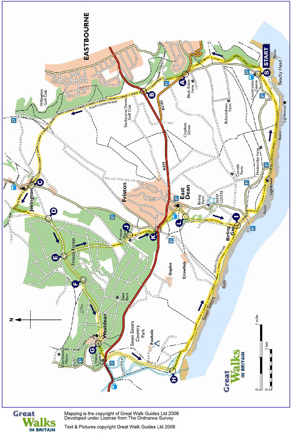
1 Beachy Head & The Seven Sisters A long and sometimes strenuous walk comprising cliff tops, forest, a meandering river and shingle beach - with stupendous coastal views. There is a somewhat shorter option. Essential Facts Route distance: Approximate time: Optional shorter route: Approx. total ascent: 21.3 km (13.3 miles) 6 hours 30 mins 17.5 km (10.9 miles) 320 metres Start point Grid Ref: TV GPS Ref: TV Recommended O.S. Map: Explorer 123 Toughness Rating Sussex 4 Please see the notes on Toughness Ratings at the end of this report
 320 metres St")
2 THE ROUTE Park beside the Beachy Head Countryside Centre for this great day s expedition. The car park gets very busy in summer (fee payable). From the Countryside Centre, S, cross the road and turn left, descending a little to a defined path. The path bears right to a footpath sign. Here, follow directions for Jevington along a grassy path until you reach the road fork at A. Cross directly and you will see a sign for Willingdon Hill. Follow the path upwards towards a trig point on the horizon. Pass this on the left keeping ahead to the A259 at B. This is part of the South Downs Way (SDW) which affords fantastic views at several points. Crossing the road, follow South Downs Way signs through Eastbourne Downs golf club. Keep ahead on this well marked path (beware cyclists and golf balls!) for 4 km, leading you down a gentle hill into the lovely village of Jevington. At the main road, C, turn right. With Jevington Tea Gardens on your right, follow the road for a few metres before taking a left turn at a South Downs Way sign, opposite The Hungry Monk restaurant. Beachy Head Follow Church Lane to the delightful church. Now take the path to the left signposted Alfriston which takes you steadily uphill. After about 0.5 km turn left onto a bridleway at a path crossroads. Continue upwards to a gate, keep ahead through a small paddock and leave by another gate opposite. Cross the horse gallop and turn left onto a track by a footpath sign. Follow this for just under 1km and where the paths cross, turn right by the sign for Friston Forest at D. Following signs for West Dean, keep ahead for 1 km to a crossroads at E. This is the beginning of the shorter route. OPTIONAL SHORTER ROUTE St. Andrews Church Turn left at E, following bridleway sign for Friston. Keep ahead descending and cross gravel track. At sign continue over private gallop downhill through woods. Keeping a wall to your right, at a footpath sign cross tarmac track to gate J. Walk field to gate opposite. Cross road and stile and bear left across field. Exit via stile into woods keeping ahead to steps in a wall. Cross wall and main road to track between church and pond. Enter the churchyard through swing gate on your left at K. Keep ahead through the churchyard crossing two stiles into a lovely field. Descend into East Dean, exiting via gate, leading to road. Keep ahead passing the Tiger Inn on left, then take the right fork signposted No Through Road. Leave the road at bridleway sign L keeping ahead to a gate climbing steadily. At a waypost keep ahead, aiming for a red roofed barn. Pass this on right continuing to a gate. Cross to another gate and a South Downs Way sign at I. Now follow the original route. Jevington Village For the main route, at E keep straight ahead, and where the track forks at F, take the right hand track to a gate marked access land. Cross the field to another gate and a sign to Westdean. Keep ahead on a wide path which becomes a gravel track. After about 300m leave the gravel on a mud path which leads to a gate. Pass this and follow the track with a house on the right then uphill and a house on the left. This track leads you down into Westdean. Keep ahead through this pretty village to a crossroads.turn left, pass a noticeboard at G and climb the steps directly in front. Continue ahead for a spectacular view of the River Cuckmere. Cross the wall, exit a gate and drop down to the Seven Sisters Country Park Visitor Centre.

3 Leaving by a gate, you will see a sign for Birling Gap pointing across the road. If you visit the centre please return to this point. Cross here (beware fast motorists!) and go through a gate onto a concrete path which follows the river. Leave the concrete through a gate following a Cycle Path sign taking you to the beach, H. At the shoreline turn left and continue to the imposing Seven Sisters. On reaching them, take one of the 'chalk scar' paths to begin the return leg. Navigation is now easier as you follow the cliffs to Birling Gap. As you hike this beautiful headland you will cross several stiles but the path is very clear. Approaching Birling Gap, go through a gate and turn right at a South Downs Way sign at I (Beachy Head 3 miles) and follow the track to Birling Gap. Following the cliffs, leave Birling Gap via the steps passing the Coastguard building making your way to the Belle Tout lighthouse. Keeping ahead past the lighthouse you can soon see the welcome sight of the Beachy Head pub,s, and a well earned drink! Refreshment Jevington Tea Gardens Tea Rooms High Street, Jevington Tel: Drinks, teas and food, garden Exceat Farmhouse Restaurant & Tea Seven Sisters Country Park Tel: Licensed restaurant, tea rooms, garden Birling Gap Hotel Hotel Birling Gap, Seven Sisters Tel: Restaurant, bar, garden The Beachy Head Public House Beachy Head Tel: Bar and meals Tiger Inn Public House The Green, East Dean Tel: Olde worlde pub and restaurant Grimaldi Restaurant Restaurant The Green, East Dean Tel: Lunches and evening meals The Tiger Inn LOCAL INFO Both Beachy Head and The Seven Sisters have extremely well appointed visitor centres at which you can brief yourself on the local history and flora and fauna of this spectacularly beautiful area. Beachy Head Countryside Centre Visitor Centre, car park and toilets Beachy Head Road, Beachy Head Seven Sisters Visitor Centre Visitor Centre, car park, toilets Exceat, Seven Sisters Country Park

4 Belle Tout lighthouse came to worldwide attention in 1999, when it was lifted up and moved approximately 50 feet inland to save it from crashing into the sea. First lit in 1834, its oil burning lamps could be seen for miles. But mists shrouding the lighthouse brought its demise with its final shutdown and sale in A replacement was built nearby at the base of the cliffs. BEACHY HEAD & THE SEVEN SISTERS G.P.S. WAYPOINTS WAYPOINT NAME MAP REF CO-ORDINATES ELEVATION: Metres BHC S S TV BHC A A TV BHC B B TV BHC C C TQ BHC D D TQ BHC E E TQ BHC F F TQ BHC G G TV BHC H H TV BHC I I TV BHC J J TV BHC K K TV BHC L L TV

5
6 Safety First Safety should always be your first priority in planning and undertaking a walk, whether on your own or leading a group. Please read these Safety First and Walking Our Routes notes. Lead a group of other walkers only if you have leadership and navigational experience adequate for the worst case conditions which may be encountered on the particular walk, bearing in mind the terrain, possible weather and navigational demands. Weigh up the capabilities of your party, in terms of fitness and walking speed. Adjust your time expectations accordingly. Ensure all your party are adequately clothed for the weather and conditions. Footwear is particularly important. Clothing must protect against cold, wet or strong sun according to the time of year. Emergencies are quite rare, but it is essential to think ahead about what to do if someone in your party sustains an injury. Will you have a First Aid kit? Is there a qualified First Aider in the party? How could help be summoned in a serious eventuality? Refreshment, particularly water, can be vital. Dehydration in hot summer conditions can be rapid, and frequent intake of fluids is essential. On tougher walks it is a good idea to tell someone where you are planning to go and when you expect to be back. Remember - mobile phones often lose reception in mountainous or isolated areas. All our walks use legitimate routes: Public Rights of Way, Public Footpaths, Bridleways, Permissive Paths, Access Land, Byways and Roads. Road walking calls for particular care. When there is no defined footpath or verge wide enough for safe walking it is usually best to walk on the right facing oncoming traffic. An exception may be a tight bend, where walkers would be more visible on the left. Occasionally you may find a public footpath blocked or unuseable. It is perfectly in order to take the shortest available diversion without damaging crops, perhaps around a field margin. It is courteous to close gates after passing through, sometimes even if the gate was open when you arrived particularly if it is obvious livestock may escape. Mutual respect for farm animals is to be encouraged! Don t frighten or annoy them, but equally don t put your party members in danger or discomfort. You certainly wouldn t be the first walkers to go round the outside of a field of frisky bullocks. Dogs should always be kept on a lead anywhere near farm animals, and under close supervision elsewhere in the countryside.

7 Walking Our Routes Our walks are designed to be negotiated using the route directions in conjunction with the map section provided. We suggest walkers also take the Ordnance Survey Explorer or Outdoor Leisure map recommended for each walk. On mountain, moorland and open heathland walks it is ESSENTIAL to have navigational expertise and tools, including the recommended Ordnance Survey map(s). Take care to observe any cautions in the route description; exposed paths, areas liable to flooding etc. Consider conditions before setting off. Will heavy rain have made a water meadow impassable? Will frost or snow make a path slippery? When navigating the route look for clues to confirm you are in the right place. Are map features where you would expect on the ground? Are features mentioned in the text where expected? If you suspect you may have taken a wrong turn, take action sooner rather than later. It is better to re-trace to a known point rather than carry on regardless with the possibility of becoming increasingly confused. All our routes are carefully checked before publication, but features can change on the ground sometimes surprisingly quickly. Footpaths may be re-routed, buildings can appear or change significantly and these days pub names seem to change frequently. The approximate time given for each walk is based on an average walking speed of 2.5 miles per hour (4 km/hour), plus an allowance for ascent, descent and any difficult terrain. Total ascent is the approximate total ascent over the whole walk. GPS users can enter in the waypoints provided in each of our walk reports. It is important to read our guide Introducing GPS for Walkers, available as a PDF file from the Great Walks in Britain web site. Remember that GPS is a great navigational tool, but only one of those available to the navigator. Never dispense with conventional map and compass and the training and skills to use them, especially on mountain, moorland or open heathland walks. TOUGHNESS RATINGS All our Sussex & The South Downs routes can be undertaken by reasonably fit walkers able to utilise our map segments, together with the route guidance notes. Always consider recent and forecast weather. Each walk has been allocated a Toughness Rating: 1. Easier walks with modest ascent and generally on well defined paths. There may be stiles or narrow gateways to negotiate. 2. Routes which are more demanding. They may include more ascent and possibly paths which are looser or more difficult underfoot. 3. More strenuous walks with some steep sections, higher paths or places which may be wet and boggy. 4. The most demanding walks in this edition. There may be prolonged steep ascents. Conditions may be challenging underfoot. Toughness Ratings are allocated in the context of the terrain in the edition area. For example a walk rated as demanding in Cambridgeshire may be equivalent to an easier or moderate route in the Brecon Beacons.

Birling Gap to Beachy Head
 Birling Gap to Beachy Head A shorter, easier exploration of this iconic coastline, taking in two historic lighthouses and an optional descent to the stony beach below the cliffs Essential Facts Route distance:
Map reading made easy
 Map reading made easy What is a map? A map is simply a plan of the ground on paper. The plan is usually drawn as the land would be seen from directly above. A map will normally have the following features:
Lincolnshire Walks. Marston & Hougham
 Lincolnshire Walks Marston & Hougham Three circular walks of 4, 8 and 11km (2 ½, 5 and 7 miles) Introduction The villages of Marston and Hougham are situated six miles north of Grantham to the east of
9e) 100m past Dynevor Arms Pub go past lone bungalow on L then turn L along designated footpath. Emerge on main Rd (A469) turn L, then after 30m
 100m past Dynevor Arms Pub go past lone bungalow on L then turn L along designated footpath. Emerge on main Rd (A469) turn L, then after 30m") 9e) 100m past Dynevor Arms Pub go past lone bungalow on L then turn L along designated footpath. Emerge on main Rd (A469) turn L, then after 30m cross rd (CAREFUL) and head up obvious footpath opposite
9e) 100m past Dynevor Arms Pub go past lone bungalow on L then turn L along designated footpath. Emerge on main Rd (A469) turn L, then after 30m cross rd (CAREFUL) and head up obvious footpath opposite
Lincolnshire Walks. Round Horncastle
 Lincolnshire Walks Round Horncastle A walk of 221/ 2 km (14miles) (with shorter options) Introduction Horncastle is an attractive market town lying at the south-west foot of the Lincolnshire Wolds and
What are the specific demands of ultra running on trails and mountainous terrain?
 Guide to training for the Montane Lakeland 50 & 100 Many people entering ultra running events will already be accomplished long distance walkers and runners, whilst others may be less experienced. In this
WHAT MAPS SHOW US Maps do 4 things:
 WHAT MAPS SHOW US Maps show us a range of features, for example: Landforms: Settlement: Communication: Land Use: Geology: Other Info: - hills - valleys - mountains - isolated dwellings - farms - villages
Aberdare Circular Walk
 Aberdare Circular Walk This is a circular walk in the countryside around Aberdare. It includes sections of open moorland with spectacular views, secluded flood meadows, woodland, ffridd and farmland on
LONDON 2 PARIS CYC LE 1
 LONDON 2 PARIS CYCLE 1 CONTENTS Itinerary 1 - Cycle London to Paris via Portsmouth 4 Itinerary 2 - Cycle London to Paris via Newhaven 5 Logistics 6 2 ITINERARIES 3 ITINERARY From London we cycle through
Functional Skills English Assessment Reading Level 2
 Learner name Learner registration number Learner signature Centre Assessment date Functional Skills English Assessment Reading Level 2 NOCN USE ONLY Question Mark 1 2 3 4 5 6 7 8 9 10 Total Instructions
Understanding the British Standard for Gaps Gates and Stiles
 Understanding the British Standard for Gaps Gates and Stiles BS5709:2006 explained The Standard covers gaps, pedestrian gates, bridle gates, kissing gates, dog gates (dog traps or latches) horse stiles,
Four Short Walks From the Mill
 Four Short Walks From the Mill With directions, duration and length of walk www.ratonera.com (0034) 958 339 560 There are steep sections on most of these walks so please wear boots or stout shoes. A stick
Margherita Peak, Mt. Stanley, 8 day trek
 RWENZORI TREKKING Margherita Peak, Mt. Stanley, 8 day trek This 8 day itinerary will take you deep into the Rwenzori Mountains to Margherita Peak, the tallest peak on Mt. Stanley and Africa s third highest
Darwen Tower Walk 1. A West Pennine Moors Trail. A walk of 2 miles, Approx. 1.5 hours steep ascent/descent
 Darwen Tower Walk 1 A West Pennine Moors Trail A walk of 2 miles, Approx. 1.5 hours steep ascent/descent WALK? Darwen Tower Walk No. 1 A walk of 2 On a clear day the Isle of Man and the hills of North
6: LANE POSITIONS, TURNING, & PASSING
 6: LANE POSITIONS, TURNING, & PASSING BASIC LANE POSITIONS Traffic law says that slower vehicles should stay to the right. But where exactly should bicycles ride? Here are some basics. Never Ride Against
FULFORD HEATH GOLF CLUB - Ride on Buggy Policy
 FULFORD HEATH GOLF CLUB - Ride on Buggy Policy 1. Introduction 1.1 Use is regulated by Fulford Heath Golf Club s policy with due regard to section 6 of The Equality Act 2010 1.2 During normal conditions
Benton MacKaye Trail - Section 2. Three Forks (FS 58) to GA. Highway 60. 11.4 miles
 to GA. Highway 60. 11.4 miles") General Benton MacKaye Trail - Section 2 Three Forks (FS 58) to GA. Highway 60 11.4 miles This is the longest and most remote section of the Benton MacKaye Trail (BMT) east of GA 5. It follows the Appalachian
General Benton MacKaye Trail - Section 2 Three Forks (FS 58) to GA. Highway 60 11.4 miles This is the longest and most remote section of the Benton MacKaye Trail (BMT) east of GA 5. It follows the Appalachian
CONTENTS. Page 3 What is orienteering? Page 4 Activity: orienteering map bingo. Page 5 Activity: know your colours. Page 6 Choosing your compass
 THE RIGHT DIRECTION SCOUT ORIENTEER ACTIVITY BADGE CONTENTS Page What is orienteering? Page 4 Activity: orienteering map bingo Page 5 Activity: know your colours Page 6 Choosing your compass Page 7 Activity:
chapter 3 basic driving skills
 chapter 3 basic driving skills When curving to the left, keep the front wheels close to the right edge of the lane to keep your driver s side rear wheels out of the next lane of traffic. Curve ahead slow
Cycle Safety. Some tips on safer cycling. Údarás Um Shábháilteacht Ar Bhóithre Road Safety Authority
 Cycle Safety Some tips on safer cycling Údarás Um Shábháilteacht Ar Bhóithre Road Safety Authority Be safe For further information on safe cycling, please look at the Rules of the Road website at www.rulesoftheroad.ie
cornering C O R N E R I N G Have you ever over-cooked a corner? Did your confidence take a knock as a result? Did you work out why it happened?
 This THINK is a pdf Norfolk is FREE Partnership to download - 011 for personal use - all content remains the property of the THINK Norfolk Partnership - 011 Page 1 Have you ever over-cooked a corner? Did
Fry Phrases Set 1. TeacherHelpForParents.com help for all areas of your child s education
 Set 1 The people Write it down By the water Who will make it? You and I What will they do? He called me. We had their dog. What did they say? When would you go? No way A number of people One or two How
Focus On You Photography TRT from Brockway Summit to Watson Lake
 Tahoe Rim Trail (TRT) From Hwy 267 (Brockway Summit) west to Watson Lake (Strong Intermediate Advanced) This trail is very demanding. It is almost 2100 ft. of climbing. The trail is up and down, up and
DRIVING IN NEW ZEALAND
 DRIVING IN NEW ZEALAND PAGE PAGE PAGE PAGE PAGE 2 ENGLISH 7 13 19 25 ESPAÑOL (SPANISH) PORTUGUÉS (PORTUGUESE) FRANÇAIS (FRENCH) DEUTSCH (GERMAN) PAGE PAGE PAGE PAGE PAGE 36 (TRADITIONAL CHINESE) 41 (JAPANESE)
Traffic Safety Quiz Show. Grade level: 4/5
 Traffic Safety Quiz Show Grade level: 4/5 Introduction: In this activity, students play a game that allows them to demonstrate and develop bicycle and pedestrian safety knowledge. The game is based on
PUSD High Frequency Word List
 PUSD High Frequency Word List For Reading and Spelling Grades K-5 High Frequency or instant words are important because: 1. You can t read a sentence or a paragraph without knowing at least the most common.
Application by National Grid Gas plc for the River Humber Gas Pipeline replacement (the application)
") Application by National Grid Gas plc for the River Humber Gas Pipeline replacement (the application) Examining Authority s (ExA) Record of Unaccompanied Inspection of Sites to Which the Application or
Application by National Grid Gas plc for the River Humber Gas Pipeline replacement (the application) Examining Authority s (ExA) Record of Unaccompanied Inspection of Sites to Which the Application or
1. When the roads are slippery, you should make turns as gentle as possible.
 GENERAL KNOWLEDGE KEY FACTS CDL 1. When the roads are slippery, you should make turns as gentle as possible. 2. The heavier a vehicle or the faster it is moving, the more heat the brakes have to absorb
PUBLIC SPACE AND SAFETY REGULATIONS FOR THE PATH EL CAMINITO DEL REY
 PUBLIC SPACE AND SAFETY REGULATIONS FOR THE PATH EL CAMINITO DEL REY GENERAL REGULATIONS Regulations that are to be followed during public visit to the path El Caminito del Rey (The King s Little Pathway)
GOLF VILAMOURA. Join us at the Club! 3 nights + 3 rounds. of golf from 340
 3 nights + 3 rounds of golf from 340 GOLF VILAMOURA One of Europe s top golfing destinations, Vilamoura, has firmly established its reputation as a quality resort for all golfers. Join us at the Club!
Code of conduct for horse riders and cyclists
 Code of conduct for horse riders and cyclists CODE OF CONDUCT FOR EQUESTRIANS AND CYCLISTS This Code of Conduct provides guidelines to ensure equestrians and cyclists co-exist harmoniously and safely when
GENERAL KNOWLEDGE PRACTICE TEST
 GENERAL KNOWLEDGE PRACTICE TEST 1. Driving under the influence of any drug that makes you drive unsafely is: a. Permitted if it is prescribed by a doctor b. Against the law c. Permitted if it is a diet
Level 2 Award in Safe Driving at Work
 Level 2 Award in Safe Driving at Work Student notes (sample) www.britsafe.org Membership Training Qualifications Audit and Consultancy Audit and Policy Consultancy and Opinion Policy Awards and Opinion
Preparation for High Elevation Hiking Treks
 Preparation for High Elevation Hiking Treks The recommendations in this document have been prepared for your convenience and should not be interpreted as exhaustive in nature. For comprehensive climb preparation
A Guide to Safe Bicycling in Hawai i
 A Guide to Safe Bicycling in Hawai i Sharing the Road: A Guide to Safe Bicycling in Hawai i What Motorists & Bicyclists Should Know Everyone has the right to be safe on Hawai i s roads. Law of the Splintered
Branscombe West Cliff and beach chalets
 BRANSCOMBE Devon from www.discoverbutterflies.com the website for the book Discover Butterflies in Britain D E Newland 2009 Branscombe West Cliff and beach chalets Branscombe is a seaside beauty spot on
FORM NOTES RISK ASSESSMENT EX D7
 FOR NOTES RISK ASSESSENT EX D7 Support Note Side 1 of 2 Written risk assessments are required for any activity where there may be perceived risks, so it would be impossible to imagine an off site visit
Chapter 1 What s in the box
 TomTom ONE Chapter 1 What s in the box What s in the box a Your TomTom ONE A Touchscreen B Charging LED C On/off button D Speaker E External antenna connector F Memory card slot G USB connector b Windscreen
Risk Assessment Form: Warwick Castle
 Risk Assessment Form: Warwick Castle About us It s amazing what you can achieve in just one day away from the classroom. A school trip to Warwick Castle will challenge your pupils, fill them with enthusiasm
Bookham Common and Slyfield
 point your feet on a new path Bookham and Slyfield Distance: 8½ km=5½ miles Region: Surrey Author: Schwebefuss Refreshments: Fetcham easy walking Date written: 11-dec-2009 Date revised: 19-feb-2013 Map:
A Guide to Accident Prevention on Motorcycles
 A Guide to Accident Prevention on Motorcycles SEE me now? Always ride with your dipped headlight on DAY AND NIGHT Avoiding the 5 most common motorcycle accidents... 1 Collisions at Junctions... These can
Lincolnshire Walks. Round Horncastle
 Page 1 Be a responsible walker Please remember countryside is a place where people live and work and where wildlife makes its home. To protect Lincolnshire countryside for or visitors please respect it
Dragonflies and a Church-on-the-Hill Chantries, Shalford, Blackheath
 point your feet on a new path Dragonflies and a Church-on-the-Hill Chantries, Shalford, Blackheath Distance: 16 km=10 miles Region: Surrey Author: Schwebefuss Refreshments: Shalford easy-to-moderate walking
Altitude Profile. Altitude (m) 108. Distance (km)
 108. Distance (km)") Stage 57: Robbio - Mortara Length: 14.3km Altitude Profile 118 116 114 112 110 108 106 0 2 4 6 8 10 12 14 16 (km) 15 Stage 57: Robbio - Mortara Length: 14.3km with only short stretches on minor roads.
Stage 57: Robbio - Mortara Length: 14.3km Altitude Profile 118 116 114 112 110 108 106 0 2 4 6 8 10 12 14 16 (km) 15 Stage 57: Robbio - Mortara Length: 14.3km with only short stretches on minor roads.
Best Foot Forward. Guided health walks. Leisure & Wellbeing
 Best Foot Forward Guided health walks Leisure & Wellbeing What is Best Foot Forward? A weekly programme of guided health walks in open spaces around Nottingham, funded by Nottingham City Council. Best
To start using your phone as a navigation device, tap the TomTom button in the Windows Mobile start menu.
 TomTom NAVIGATOR 1. Before you start... Before you start... Setting up To start using your phone as a navigation device, tap the TomTom button in the Windows Mobile start menu. To set up your navigation
Videos for Safety Meetings
 Videos for Safety Meetings 2474 2005, ERI Safety Videos OPERATING ELECTRIC PALLET JACKS SAFELY This easy-to-use Leader s Guide is provided to assist in conducting a successful presentation. Featured are:
The Water Cycle Now You See It, Now You Don t
 The Water Cycle Now You See It, Now You Don t Unit: Salinity Patterns & the Water Cycle l Grade Level: Elementary l Time Required: Introduction - 30 min. - Activity as groups 45min Wrap Up 20 min l Content
10.1 WILL HEY FARM WATFORD LANE NEW MILLS RETENSION OF NEW STABLE BLOCK, SAND PADDOCK AND ASSOCIATED EARTHWORKS AND LANDSCAPING (FULL - MINOR)
") HPK/2012/0207 03/04/2012 WILL HEY FARM WATFORD LANE NEW MILLS MR & MRS M WILSON KIRSTY WILSON EQUINE AND WILL HEY FARM BED & BREAKFAST RETENSION OF NEW STABLE BLOCK, SAND PADDOCK AND ASSOCIATED EARTHWORKS
HPK/2012/0207 03/04/2012 WILL HEY FARM WATFORD LANE NEW MILLS MR & MRS M WILSON KIRSTY WILSON EQUINE AND WILL HEY FARM BED & BREAKFAST RETENSION OF NEW STABLE BLOCK, SAND PADDOCK AND ASSOCIATED EARTHWORKS
Advantages and Disadvantages of One Way Streets October 30, 2007
 Advantages and Disadvantages of One Way Streets October 30, 2007 0 P age Background As the revitalization of the Central Waterfront area moves forward, one issue that might need closer analysis is the
Preventing Falls, Slips and Trips
 Preventing Falls, Slips and Trips Falls/Slips/Trips (FSTs) You take hundreds of steps every day, but how many of those steps do you take seriously? Please take a few minutes to understand how Falls/Slips/Trips
Bicycle Safety Quiz Answers Parental Responsibilities
 Bicycle riding is a great way to get into shape and enjoy the outdoors. To remain safe on Illinois roads, it is important to follow the same traffic safety laws that govern vehicle drivers. No amount of
CHAPTER 2 TRAFFIC SIGNS AND HIGHWAY MARKINGS
 CHAPTER 2 TRAFFIC SIGNS AND HIGHWAY MARKINGS This chapter summarizes traffic signs, signals and road markings that control the flow of traffic, making streets and highways safer for motorists, bicyclists
USING THE MOBILE PHONE WHILE DRIVING. Using a mobile phone while driving can significantly impair a driver s:
 USING THE MOBILE PHONE WHILE DRIVING Is it dangerous to use the phone while driving? Driving is a complex task, requiring drivers to use and coordinate a number of skills. Any lapse in concentration increases
Run Off Your Feet - Tips For Planning A Running Group
 Effectively engaging women in running SUPPORT& ADVICE Get your Group noticed WHERE TO MEET? KEEP MOTIVATED! SESSION STRUCTURE Delivering your sessions Routes for success TIMING is everything make it SUITABLE
GUY LEONARD & CO. Premier Selection. Slinfold, West Sussex (ID: 35189) Guide Price 925,000 Freehold
 Guide Price 925,000 Freehold") GUY LEONARD & CO Premier Selection Slinfold, West Sussex (ID: 35189) Set in approximately one acre, a substantial detached house offering extensive accommodation, with a three bedroom separate annexe plus
GUY LEONARD & CO Premier Selection Slinfold, West Sussex (ID: 35189) Set in approximately one acre, a substantial detached house offering extensive accommodation, with a three bedroom separate annexe plus
Chapter Two. Training by Wild Women On Top
 Chapter Two Training by Wild Women On Top Your decision to enter Coastrek will give you an opportunity to break down physical and mental barriers and achieve an extraordinary goal. Walking continuously
Your Way 100KM. www.ultrachallenge.com 50KM 25KM. 10/11 September. 27/28 August. 2/3 July. 30 April to 1 May. 28/29 May ISLE OF WIGHT
 e g n e l l a h C r u o Y Your Way 50KM 100KM 25KM ISLE OF WIGHT WALK, JOG OR RUN IT 30 April to 1 May 28/29 May 2/3 July 27/28 August 10/11 September Ultra Series 2016 What challenge are you taking on
Backcountry Avalanche Rescue Reference
 1 Backcountry Avalanche Rescue Reference This document is part of Decision Making in Avalanche Terrain: a fieldbook for winter backcountry users by Pascal Haegeli, Roger Atkins and Karl Klassen and provides
H is for HELP! He was employed as an EMS pilot in Buffalo New York for about 2 years, than transferred to work as a relief pilot through out WI.
 H is for HELP! Wind Turbines and EMS helicopters in Wisconsin This interview with retired EMS pilot Ray Slavik, was submitted to the Calumet County Ad Hoc Committee researching proposed ordinances governing
in association with Great Deptford House High Bickington Umberleigh Devon GUIDE 450,000+
 in association with Great Deptford House High Bickington Umberleigh Devon GUIDE 450,000+ Great Deptford House High Bickington, Umberleigh, Devon EX37 9BP FOR SALE BY PUBLIC AUCTION (Unless sold prior by
Disabled Access Guide
 Disabled Access Guide The Royal Hotel South Parade Weston-Super-Mare Somerset BS23 1JP Tel: 01934 423 100 Fax : 01934 415 135 Email: Web: [email protected] www.royalhotelweston.com Location
Woolborough Farm. Woolborough Lane,Outwood, Surrey, RH1 5QR
 Woolborough Farm Woolborough Lane,Outwood, Surrey, RH1 5QR Woolborough Farm Woolborough Lane,Outwood, Surrey, RH1 5QR Smallfield 2.6 miles, Redhill 4.9 miles, Reigate 5.1miles, Gatwick 8.9 miles, London
Maximum speed. Stop and Give way to Manually operated temporary No entry for give way traffic on STOP and GO signs vehicular traffic major road
 Signs giving orders Signs with red circles are mostly prohibitive. Plates below signs qualify their message. Entry to 20 mph zone End of 20 mph zone Maximum speed National speed limit applies School crossing
BRITISH GEOLOGICAL SURVEY
 BRITISH GEOLOGICAL SURVEY RISK ASSESSMENT FOR WORKING IN QUARRIES Definitions from Health & Safety Executive anything that can cause harm. the chance that someone will be harmed by the hazard. Health and
OCE. A guide to using an electric wheelchair safely. Information for patients and their families. www.noc.nhs.uk/oce. page 1
 www.noc.nhs.uk/oce A guide to using an electric wheelchair safely Information for patients and their families OCE Oxford Centre for Enablement Neurological Rehabilitation Service page 1 page 2 Contents
TREK DHARAMSALA LITTLE TIBET
 TREK DHARAMSALA LITTLE TIBET 1 ITINERARY- OUTLINE FOR BESPOKE TRIPS This trek is in the Indian Himalaya, in the shadow of the mighty Daula Dhar 5490m. For eight days we are immersed in the culture and
Madrid Lisbon MT Bike Tour
 Madrid to Lisbon, the challenging mountain route! An incredible route trough the central mountains of Spain and Portugal! Spectacular trails, beautiful mountain scenary, historic villages and castles.
Mulberry Farmhouse SANDY LANE LOWER FAILAND
 Mulberry Farmhouse SANDY LANE LOWER FAILAND Mulberry Farmhouse SANDY LANE LOWER FAILAND A charming period farmhouse in a rural setting, within easy striking distance of Clifton Village Drawing room Dining
Connemara English Language School
 Connemara English Language School Study English in a family run English language school in a beautiful rural location in County Galway, Ireland. ENGLISH LANGUAGE COURSES FOR FAMILIES, ADULTS & JUNIORS
Risk Assessment for visits by schools and other groups including children.
 Perrygrove Railway Risk Assessment for visits by schools and other groups including children. Page 1 Risk Assessment for visits by schools and other groups including children. Introduction Perrygrove Railway
Access Statement for Wood View Guest House
 Access Statement for Wood View Guest House Introduction Wood View is set on the village green in Austwick and offers five en-suite guest rooms. The house is three hundred years old and offers accommodation
Daisy Farm, Front Street, Lastingham, York, YO62 6TL Guide Price: 550,000
 Daisy Farm, Front Street, Lastingham, York, YO62 6TL Guide Price: 550,000 Daisy Farm, Front Street, Lastingham, York, YO62 6TL Daisy Farm is a beautiful stone built period property built around 1770 nestling
The Roaches Asset Management Review. Draft Objectives for External Consultation. Fundamental Principles
 The Roaches Asset Management Review Draft Objectives for External Consultation Fundamental Principles the area of land under review is the Roaches Estate and Gradbach Car Park as shown on the attached
Safety-conscious Drivers Prevent Crashes. Defensive Driving: Managing Visibility, Time and Space. Improve Your Defensive Driving Skills
 Defensive Driving: Managing Visibility, Time and Space Motor vehicle travel is the primary means of travel in the United States. With all the benefits that come along with mobility, there are thousands
The Older And Wiser Driver
 The Older And Wiser Driver AAA Foundation for Traffic Safety Sharpening Your Driving Skills Aging is inevitable, but growing older doesn t have to mean giving up an active life. While aging does impose
DRIVING TEST POSSIBLE QUESTIONS & ANSWERS.
 DRIVING TEST POSSIBLE QUESTIONS & ANSWERS. Question 1. What shape and colour is a warning sign? Diamond Shape - Yellow and Black Question 2. When should you not drive? While under the influence of alcohol,
How To Cycle In France
 Further Information London to Paris This document has been compiled by our challenge leaders. Please do take into account your own personal preferences and common sense! We welcome feedback on how this
Ride Safe. How you can avoid the 5 most common motorcycle accidents. Produced with the support of The Department for Transport
 Ride Safe How you can avoid the 5 most common motorcycle accidents Produced with the support of The Department for Transport Ride Safe How you can avoid th Riding a motorbike safely requires both skill
SEE THE USA FOR $50 A DAY
 Travel Cheap (Rev 3) Karl Belser 17 October 2002 5544 Drysdale Drive (1415 words) San Jose, CA 95124 408-723-0315 SEE THE USA FOR $50 A DAY By Karl Arnold Belser Do you like to travel, have limited money,
Characteristics of Different Rural Areas in Thetford
 Characteristics of Different Rural Areas in Thetford Vermont is the most rural state in the United States. You can look it up. According to the Census Bureau, 72.3% of Vermont s population was rural in
ROVANIEMI SUMMER SAFARIS 2016
 ROVANIEMI SUMMER SAFARIS 2016 Join us with an open mind, and we guarantee that you will return home with a smile on your face. The new world will be nature itself and the new strength will be pure natural
Bicycle riding is a great way to get into shape
 Bicycle riding is a great way to get into shape and have fun. To remain safe on Illinois roads, it is important to follow the same traffic safety laws that govern vehicle drivers. No amount of bicycle