Geographic Information Systems. ASM 215 Feb 2013 Larry Theller
|
|
|
- Marjorie Simon
- 9 years ago
- Views:
Transcription
1 Geographic Information Systems ASM 215 Feb 2013 Larry Theller

2 Schedule Wednesday GIS lecture Disc of homework Lab Thursday GPS Feb 28 Lab ABE 105 or 116 computer labs

3 GIS Lecture today History Software details Current GIS uses Hot GIS trends Feb 28 lab

4 Geographic Information Systems GIS means Geographical Information System its called SYSTEM because there is information behind the map. You may ask questions of the data or of the map

5 GIS Evolution Map viewing >> Map Analysis Past: map layers = little files Now: map layers = huge databases We use Terabytes of images Streaming GIS data = music on the web Web-based tools do not install on your computer

6 Example: Map of cholera outbreak, 1854 (Based on John Snow s map) Other analysis examples?
 Other analysis")
7 GIS is not CAD Difference between CAD and GIS software: you ask questions in GIS Three levels of GIS applications: Inventory (What is there?) Analysis (Answering questions) Modeling (Making predictions) CAD stands for Computer-Aided Design
 Analysis (Answering questions) Modeling (Making")
8 A GIS is a software system that connects map layers with tables of information. Tabular Data Image: ESRI course Learning ArcGIS Desktop 2007

9 Spatial Analysis is considered the crux of GIS. Why? Spatial analysis is the means of adding value to geographic data. It turns data into information Spatial analysis can reveal things that might otherwise be invisible. It can make what is implicit explicit.

10 More about spatial analysis Some methods are highly mathematical. All effective spatial analysis requires an intelligent user, not just a powerful computer. Spatial analysis is best seen as a collaboration between the computer and the human, in which both play vital roles. (Geographic Information Systems and Science, Wiley, 2001)

11 The GIS analytical process 1. Define the problem 2. Define the criteria 3. Identify the data you need 4. Plan the analysis 5. Prepare the data for analysis 6. Execute the analysis 7. Examine and present the results

12 A GIS originally was software installed on a computer and using local files as layers with attached tables of information.

13 GIS and the internet GIS Users quickly adopted the internet for download of large files With satellite-sensors and digital camera the files soon became gigantic Not efficient to copy to every PC in Indiana

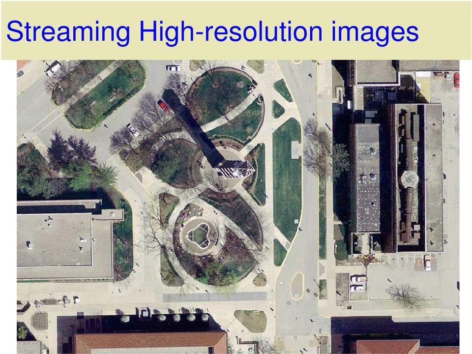
14 This map is drawing data from two streaming data sources on the web and from files on the hard drive. Named streets and property parcel lines from the Tippecanoe County GIS server These high-resolution aerial photos use 8 terabytes of storage at IU, which is why you do not want to download files anymore

15 Streaming High-resolution images
16 Don t Download that image If you don t need to change it, maybe you don t need to download it If you need to change it, edit it or clip out parts, you need to have your own copy. Aerial Photos Indiana 2005 photos are: 8500 gigabyes Or 2000 DVD s Sure you want to download that?

17 Location Business Services: The geo fence You know when a vehicle passes into or out of a zone. Monitor deliveries, service staff, employees, felons, ambulances, pizza delivery guy.. m

18 Web Location Business Services Target marketing geographically Cell phone yellow pages Google and Mapquest, Spots on the map, Gas, food, etc. ebay Nearby items

19 Mobile GoogleEarth Google Earth for iphone Google Earth for Android

20 GIS software on your desktop ESRI ArcGIS (ArcMap, ArcCatalog) Other Commercial : ThinkMap, Autodesk Map 3D or Civil 3D, MapInfo Commercial but free Viewers: Google Earth ArcGIS Explorer Open Source GIS: udig (user-friendly Desktop Internet GIS) Quantun GIS (most full-featureed and free)
 Quantun GIS (most full-featureed")
21 udig free and web-oriented Labels Scale Bar Streaming data; databases, tables, shapefiles Legend udig Open Source GIS
22 Quantum GIS (free)
23 Overlay Combine spatial and attribute data from two or more spatial data layers Union and Intersect most common
24 Buffers Buffer = region that is less than or equal to a specified distance from a feature or features Can buffer point, line or area feature Raster or vector data
25 Clip, Intersect, and Union
26
27 Map Gallery
28 Online Map
29
30 Build my map by adding layers
31 The Lab Exercise - ArcMap
32 THE END
Introduction to GIS. http://libguides.mit.edu/gis
 Introduction to GIS http://libguides.mit.edu/gis 1 Overview What is GIS? Types of Data and Projections What can I do with GIS? Data Sources and Formats Software Data Management Tips 2 What is GIS? 3 Characteristics
GEOGRAPHIC INFORMATION SYSTEMS Lecture 20: Adding and Creating Data
 Adding Existing Data Into ArcGIS - there are many different ways to get data into ArcGIS GEOGRAPHIC INFORMATION SYSTEMS Lecture 20: Adding and Creating Data Add Data - normally we use the Add Data button
What is GIS? Geographic Information Systems. Introduction to ArcGIS. GIS Maps Contain Layers. What Can You Do With GIS? Layers Can Contain Features
 What is GIS? Geographic Information Systems Introduction to ArcGIS A database system in which the organizing principle is explicitly SPATIAL For CPSC 178 Visualization: Data, Pixels, and Ideas. What Can
Institute of Natural Resources Departament of General Geology and Land use planning Work with a MAPS
 Institute of Natural Resources Departament of General Geology and Land use planning Work with a MAPS Lecturers: Berchuk V.Y. Gutareva N.Y. Contents: 1. Qgis; 2. General information; 3. Qgis desktop; 4.
A Brief Explanation of Basic Web Services
 A Brief Explanation of Basic Web Services What is REST? REpresentational State Transfer (REST) is a way for software to work when distributed across a network. For example, if I want to view the Iowa Dept
Data Integration for ArcGIS Users Data Interoperability. Charmel Menzel, ESRI Don Murray, Safe Software
 Data Integration for ArcGIS Users Data Interoperability Charmel Menzel, ESRI Don Murray, Safe Software Product overview Extension to ArcGIS (optional) Jointly developed with Safe Software Based on Feature
Easily add Maps and Geo Analytics in MicroStrategy
 Easily add Maps and Geo Analytics in MicroStrategy Agenda Introduction Configure to use Maps in MicroStrategy MicroStrategy Geo Analysis Capabilities and Examples Key Takeaways and Q&A Why Geospatial Analysis
Lecture 8. Online GIS
 Lecture 8 Online GIS Lecture 8: Outline I. Online GIS 1. Google Earth 2. MSN Live Maps II. Open Source GIS III. ArcGIS Server and the ESRI suite of online software utility options IV. Advanced Data Mining
Mapping Mashup/Data Integration Development Resources
 Mapping Mashup/Data Integration Development Resources David Hart GIS Specialist University of Wisconsin Sea Grant Institute October 6, 2008 Virtual Globes A virtual globe is a 3D software model or representation
Introduction to Geographic Information Systems. A brief overview of what you need to know before learning How to use any GIS software packages
 Introduction to Geographic Information Systems A brief overview of what you need to know before learning How to use any GIS software packages 1 What is GIS? More than map-making software GIS is a system
GIS: Geographic Information Systems A short introduction
 GIS: Geographic Information Systems A short introduction Outline The Center for Digital Scholarship What is GIS? Data types GIS software and analysis Campus GIS resources Center for Digital Scholarship
Syllabus AGET 782. GIS for Agricultural and Natural Resources Management
 Syllabus AGET 782 Course Title: GIS for Agricultural and Natural Resources Management Course Abbreviation: AGET 782 Course Credits: Instructor: Course Description: Required Text: 3 hours Timothy N. Burcham,
The Use of Geographic Information Systems in Risk Assessment
 The Use of Geographic Information Systems in Risk Assessment With Specific Focus on the RiVAMP Methodology Presented by Nadine Brown August 27, 2012 Climate Studies Group Mona Climate Change Workshop Presentation
Lecture 3: Models of Spatial Information
 Lecture 3: Models of Spatial Information Introduction In the last lecture we discussed issues of cartography, particularly abstraction of real world objects into points, lines, and areas for use in maps.
Compiled from ESRI s Web site: http://www.esri.com. 1. What Is a GIS?
 Compiled from ESRI s Web site: http://www.esri.com 1. What Is a GIS? A geographic information system (GIS) is a computer-based tool for mapping and analysing things that exist and events that happen on
ANALYSIS 3 - RASTER What kinds of analysis can we do with GIS?
 ANALYSIS 3 - RASTER What kinds of analysis can we do with GIS? 1. Measurements 2. Layer statistics 3. Queries 4. Buffering (vector); Proximity (raster) 5. Filtering (raster) 6. Map overlay (layer on layer
An Introduction to Open Source Geospatial Tools
 An Introduction to Open Source Geospatial Tools by Tyler Mitchell, author of Web Mapping Illustrated GRSS would like to thank Mr. Mitchell for this tutorial. Geospatial technologies come in many forms,
How to georectify an image in ArcMap 10
 How to georectify an image in ArcMap 10 The University Library has a large collection of historical aerial photos for some North Carolina Counties ( http://www.lib.unc.edu/reference/gis/usda/index.html
As noted in previous chapters, crime analysis relies heavily on computer
 07-Boba-4723.qxd 6/9/2005 3:43 PM Page 101 7 Crime Analysis Technology As noted in previous chapters, crime analysis relies heavily on computer technology, and over the past 15 years significant improvements
Web and Mobile GIS Applications Development
 Web and Mobile GIS Applications Development Presented by : Aamir Ali Manager Section Head (GIS Software Customization) Pakistan Space and Upper Atmosphere Research Commission (SUPARCO) Geographical Information
The Development and Implementation of a GIS System for Sunde Land Surveying, LLC.
 The Development and Implementation of a GIS System for Sunde Land Surveying, LLC. Ryan R. Bormann 1,2 1 Department of Resource Analysis, Saint Mary s University of Minnesota, Winona, MN 55987. 2 Sunde
Mapping Mashup/Data Integration Development Resources Teaching with Google Earth and Google Ocean Stone Lab August 13, 2010
 Mapping Mashup/Data Integration Development Resources Teaching with Google Earth and Google Ocean Stone Lab August 13, 2010 David Hart GIS Specialist University of Wisconsin Sea Grant Institute Virtual
What do I do first in ArcView 8.x? When the program starts Select from the Dialog box: A new empty map
 www.library.carleton.ca/find/gis Introduction Introduction to Georeferenced Images using ArcGIS Georeferenced images such as aerial photographs or satellite images can be used in many ways in both GIS
A Method Using ArcMap to Create a Hydrologically conditioned Digital Elevation Model
 A Method Using ArcMap to Create a Hydrologically conditioned Digital Elevation Model High resolution topography derived from LiDAR data is becoming more readily available. This new data source of topography
Geographic Information Systems (GIS) @ GIS at UCSD. Here to help you explore our world
 @ GIS at UCSD. Here to help you explore our world") Geographic Information Systems (GIS) @ GIS at UCSD Here to help you explore our world GIS at UCSD what it is and what it means to you Tracey Hughes UCSD GIS Coordinator 2006 Image from Google Earth An
Geographic Information Systems (GIS) @ GIS at UCSD Here to help you explore our world GIS at UCSD what it is and what it means to you Tracey Hughes UCSD GIS Coordinator 2006 Image from Google Earth An
Open Source Desktop GIS Solutions for the Not-So Casual User
 Open Source Desktop GIS Solutions for the Not-So Casual User Roger C. Lowe III Warnell School of Forestry and Natural Resources The University of Georgia Athens, GA 30605 [email protected] Abstract Ask
A GIS helps you answer questions and solve problems by looking at your data in a way that is quickly understood and easily shared.
 A Geographic Information System (GIS) integrates hardware, software, and data for capturing, managing, analyzing, and displaying all forms of geographically referenced information. GIS allows us to view,
Subject: Using Google Earth, Google Earth Pro, and Google Maps for FWS activities
 Subject: Using Google Earth, Google Earth Pro, and Google Maps for FWS activities Page 1 of 5 As an FWS employee, can I use Google mapping software or applications to help me with my job? The short answer
The UCC-21 cognitive skills that are listed above will be met via the following objectives.
 Master Syllabus Department of Geography GEOG 265: Introduction to Geographic Information Systems Course Description Fundamentals of geographic information systems (GIS). How to visualize geographic information
INTRODUCTION TO ARCGIS SOFTWARE
 INTRODUCTION TO ARCGIS SOFTWARE I. History of Software Development a. Developer ESRI - Environmental Systems Research Institute, Inc., in 1969 as a privately held consulting firm that specialized in landuse
A Workflow for Creating and Sharing Maps
 A Workflow for Creating and Sharing Maps By Keith Mann, Esri What You Will Need Item Source ArcGIS Online for Organizations subscription ArcGIS 10.1 for Desktop (Any license level) ArcGIS Spatial Analyst
GIS Project Manager. Position #1
 Position #1 GIS Project Manager DataMap Intelligence is seeking a highly qualified GIS Project Manager to join our fast growing GIS team. You must have a strong, well rounded background in GIS and extensive
Data Visualization Techniques and Practices Introduction to GIS Technology
 Data Visualization Techniques and Practices Introduction to GIS Technology Michael Greene Advanced Analytics & Modeling, Deloitte Consulting LLP March 16 th, 2010 Antitrust Notice The Casualty Actuarial
Big Data and Analytics: Getting Started with ArcGIS. Mike Park Erik Hoel
 Big Data and Analytics: Getting Started with ArcGIS Mike Park Erik Hoel Agenda Overview of big data Distributed computation User experience Data management Big data What is it? Big Data is a loosely defined
Chapter 6: Data Acquisition Methods, Procedures, and Issues
 Chapter 6: Data Acquisition Methods, Procedures, and Issues In this Exercise: Data Acquisition Downloading Geographic Data Accessing Data Via Web Map Service Using Data from a Text File or Spreadsheet
Cookbook 23 September 2013 GIS Analysis Part 1 - A GIS is NOT a Map!
 Cookbook 23 September 2013 GIS Analysis Part 1 - A GIS is NOT a Map! Overview 1. A GIS is NOT a Map! 2. How does a GIS handle its data? Data Formats! GARP 0344 (Fall 2013) Page 1 Dr. Carsten Braun 1) A
EXPLORING AND SHARING GEOSPATIAL INFORMATION THROUGH MYGDI EXPLORER
 EXPLORING AND SHARING GEOSPATIAL INFORMATION THROUGH MYGDI EXPLORER Subashini Panchanathan Malaysian Centre For Geospatial Data Infrastructure ( MaCGDI ) Ministry of National Resources and Environment
The Courses. Covering complete breadth of GIS technology from ESRI including ArcGIS, ArcGIS Server and ArcGIS Engine.
 ESRI India: Corporate profile ESRI India A profile India s Premier GIS Company Strategic alliance between ESRI Inc. and NIIT Technologies Adjudged as India s Best GIS Solutions Company - Map India 2001
RESPONSE TO GIS SERVICES RFP. 1. What version of ArcGIS software are you using? If it is not the latest, is there a plan to upgrade?
 RESPONSE TO GIS SERVICES RFP 1. What version of ArcGIS software are you using? If it is not the latest, is there a plan to upgrade? We are currently using ArcGIS 10.x as follows: ArcGIS for Desktop - Mixed
GIS Tools for Land Managers
 Citation: Karl, J. 2010. GIS Tools for Land Managers. Sound Science White Paper Series #05. www.sound-science.org. GIS Tools for Land Managers Most land managers recognize that geographic information systems
ArcGIS 3: Performing Analysis. Student Edition
 ArcGIS 3: Performing Analysis Student Edition Copyright 2016 Esri All rights reserved. Course version 4.0. Version release date March 2016. Printed in the United States of America. The information contained
Step by Step Guide for GIS Cloud Applications
 Step by Step Guide for GIS Cloud Applications All in one manual for: Map Editor Map Viewer Asset Data Collection and Management Fleet Management Roadwork Management and Coordination Mobile Data Collection
University of Arkansas Libraries ArcGIS Desktop Tutorial. Section 5: Analyzing Spatial Data. Buffering Features:
 : Analyzing Spatial Data Buffering Features: A buffer operation is one of the most common spatial analysis tools. A buffer is a map feature that represents a uniform distance around a feature. When creating
FOR375 EXAM #2 STUDY SESSION SPRING 2016. Lecture 14 Exam #2 Study Session
 FOR375 EXAM #2 STUDY SESSION SPRING 2016 Lecture 14 Exam #2 Study Session INTRODUCTION TO REMOTE SENSING TYPES OF REMOTE SENSING Ground based platforms Airborne based platforms Space based platforms TYPES
WHAT IS GIS - AN INRODUCTION
 WHAT IS GIS - AN INRODUCTION GIS DEFINITION GIS is an acronym for: Geographic Information Systems Geographic This term is used because GIS tend to deal primarily with geographic or spatial features. Information
SCIENCE-BASED GIS SOLUTIONS. www.earthanalytic.com
 SCIENCE-BASED GIS SOLUTIONS www.earthanalytic.com Pipeline Routing, Site Selection, Cost Estimation and Risk Management Tools for Energy SmartFootprint is an extension to ArcGIS designed to assist planning,
Harvard Data Visualization Project
 Esri User Conference, July 12-15, San Diego California Harvard Data Visualization Project Spatio-Temporal Visualization of Global Phenomena: 1850 to the Present Harvard Business School Geoffrey Jones Walter
Publishing geospatial data to the web using the EEA infrastructure
 Publishing geospatial data to the web using the EEA infrastructure *Note: Map Services should be published using the EEA Map Services Tick Sheet for guidance. Contact Sebastien Petit ([email protected])
ArcGIS Data Models Practical Templates for Implementing GIS Projects
 ArcGIS Data Models Practical Templates for Implementing GIS Projects GIS Database Design According to C.J. Date (1995), database design deals with the logical representation of data in a database. The
GEOREFERENCING HISTORIC MAPS USING ARCGIS DESKTOP 10
 5/20/2011 BALL STATE UNIVERSITY LIBRARIES GIS RESEARCH AND MAP COLLECTION GEOREFERENCING HISTORIC MAPS USING ARCGIS DESKTOP 10 GEOREFERENCING HISTORIC MAPS USING ARCGIS DESKTOP 10 *This tutorial is appropriate
Web-Based Enterprise Data Visualization a 3D Approach. Oleg Kachirski, Black and Veatch
 Web-Based Enterprise Data Visualization a 3D Approach Oleg Kachirski, Black and Veatch Contents - Introduction - Why 3D? - Applications of 3D - 3D Content Authoring - 3D/4D in GIS - Challenges of Presenting
Google Enterprise Geospatial. Andrea Aymerich Head of Geo Enterprise Italy
 Google Enterprise Geospatial Andrea Aymerich Head of Geo Enterprise Italy Google Confidential 2011 Google Internet Traffic Growth Location is anywhere Worldwide smartphone and tablet shipment exceed PC
GIS I Business Exr02 (av 9-10) - Expand Market Share (v3b, Jul 2013)
 - Expand Market Share (v3b, Jul 2013)") GIS I Business Exr02 (av 9-10) - Expand Market Share (v3b, Jul 2013) Learning Objectives: Reinforce information literacy skills Reinforce database manipulation / querying skills Reinforce joining and mapping
GIS I Business Exr02 (av 9-10) - Expand Market Share (v3b, Jul 2013) Learning Objectives: Reinforce information literacy skills Reinforce database manipulation / querying skills Reinforce joining and mapping
BLM Personnel & REA Collaborator Access. Accessing REA Data, Maps, & Models through SharePoint
 Accessing REA Data, Maps, & Models through SharePoint BLM Personnel & REA Collaborator Access To access REA data and map services through the BLM network, follow the steps provided below. They will take
GGR272: GEOGRAPHIC INFORMATION AND MAPPING I. Course Outline
 DESCRIPTION GGR272: GEOGRAPHIC INFORMATION AND MAPPING I Course Outline This course is an introduction to digital mapping and spatial analysis using a geographic information system (GIS). Students learn
ArcGIS Desktop I: Getting Started with GIS
 ArcGIS Desktop I: Getting Started with GIS All rights reserved. Course version 1.0. Revised May 2008. Printed in the United States of America. The information contained in this document is the exclusive
Oklahoma s Open Source Spatial Data Clearinghouse: OKMaps
 Oklahoma s Open Source Spatial Data Clearinghouse: OKMaps Presented by: Mike Sharp State Geographic Information Coordinator Oklahoma Office of Geographic Information MAGIC 2014 Symposium April 28-May1,
Create and share a map with GIScloud.com
 Create and share a map with GIScloud.com GIS Cloud is a web based Geographic Information System powered by Cloud Computing and with the full power of desktop GIS. It allows users to create and access your
1. Launch ArcCatalog, then navigate to the following location using the directory tree on the left side of the screen:
 Vector Data Analysis I: Buffering Today we will use ArcMap and ArcToolbox to manipulate vector-based geographic data. The results of these simple analyses will allow us to visualize complex spatial relationships.
Syllabus Introduction to GIS 120
 GIS 120 Ticket 70552 03:55pm to 6:50pm MW first class meeting August 20th last class meets December 5th Syllabus Introduction to GIS 120 Instructor: Warren Roberts Rio Hondo College GIS Los Angeles County
Creating Maps in QGIS: A Quick Guide
 Creating Maps in QGIS: A Quick Guide Overview Quantum GIS, which is often called QGIS, is an open source GIS desktop application. Comparing to ArcGIS, QGIS can be installed on various operating systems,
Quick Start Guide to. ArcGISSM. Online. for Public Accounts
 Quick Start Guide to ArcGISSM Online for Public Accounts Using ArcGIS Online with a Public Account ArcGIS SM Online is a cloud-based mapping platform that allows you to easily and quickly make maps, collaborate,
Step 1 Preparation and Planning
 Its daunting starting any GIS Web or Mobile project. Where does one begin? This 3 step guide should help you get past your project inertia and start things moving rapidly forward. Step 1 Preparation and
Government 1008: Introduction to Geographic Information Systems. LAB EXERCISE 4: Got Database?
 Government 1008: Introduction to Geographic Information Systems Objectives: Creating geodatabases Joining attribute tables Attribute and location based queries Spatial joins Creating spatial and attribute
ArcGISSM. Online. The Mapping Platform for Your Organization
 ArcGISSM Online The Mapping Platform for Your Organization ArcGIS Online is a cloud-based platform for making and sharing maps, apps, and other geographic data and content. Knowledge Workers Policy Makers
Tutorial 8 Raster Data Analysis
 Objectives Tutorial 8 Raster Data Analysis This tutorial is designed to introduce you to a basic set of raster-based analyses including: 1. Displaying Digital Elevation Model (DEM) 2. Slope calculations
There are various ways to find data using the Hennepin County GIS Open Data site:
 Finding Data There are various ways to find data using the Hennepin County GIS Open Data site: Type in a subject or keyword in the search bar at the top of the page and press the Enter key or click the
Choosing the best route for Pipeline Construction
 ESRI User Conference July 17, 2014 Choosing the best route for Pipeline Construction Tammy Hall, GIS Application Manager Becky Swails, GIS Data Manager Troy Bumgardner, GIS Business Analyst Who is Williams?
What is GIS. What is GIS? University of Tsukuba. What do you image of GIS? Copyright(C) ESRI Japan Corporation. All rights reserved.
 ESRI Japan Corporation. All rights reserved.") What is GIS University of Tsukuba Graduate School of Life and Environmental Science April 21 st, 2011 What is GIS? What do you image of GIS? Gas Insulated Switch Groupe Interventional Speciale Geographic
What is GIS University of Tsukuba Graduate School of Life and Environmental Science April 21 st, 2011 What is GIS? What do you image of GIS? Gas Insulated Switch Groupe Interventional Speciale Geographic
Latest Developments in Oceanographic Applications of GIS including!
 Latest Developments in Oceanographic Applications of GIS including! Near-Real-Time Interactive Map Exemplars & Scientific Empowerment Through Storytelling Dawn Wright Esri Chief Scientist Affiliate Professor,
WFP Liberia Country Office
 1 Oscar Gobbato [email protected] [email protected] WFP Liberia Country Office GIS training - Summary Objectives 1 To introduce to participants the basic concepts and techniques in using Geographic
Guidelines on Information Deliverables for Research Projects in Grand Canyon National Park
 INTRODUCTION Science is playing an increasing role in guiding National Park Service (NPS) management activities. The NPS is charged with protecting and maintaining data and associated information that
Introduction to the ArcGIS Data Model and Application Structure
 Introduction to the ArcGIS Data Model and Application Structure RNR/GEOG 417/517 Lab 6 Presentation Overview The georelational data model Structure of ArcGIS software Structure of an ArcGIS workspace Demonstrations/previews
Insight for location-powered decision making.
 Location Intelligence Geographic Information Systems MapInfo Pro Insight for location-powered decision making. Data drives our decisions every day. Blend this data with geography and you can visualise
MINE MAP DIGITIZATION & GIS IMPLIMENTATION
 MINE MAP DIGITIZATION & GIS IMPLIMENTATION Patrick Jaquay Mining Specialist IMCC Conference 2/16/2012 Pennsylvania Department of Environmental Protection MINE MAP DIGITIZATION & GIS IMPLIMENTATION Why
Esri Maps for Salesforce and Microsoft Dynamics CRM
 Esri Maps for Salesforce and Microsoft Dynamics CRM Daniel Lee, Lucy Guerra Esri UC 2014 Technical Workshop Agenda CRM and Esri Esri Maps for Demos Road Ahead Esri UC 2014 Technical Workshop Esri Maps
GEOGRAPHIC INFORMATION SYSTEMS
 GIS GEOGRAPHIC INFORMATION SYSTEMS FOR CADASTRAL MAPPING Chapter 6 2015 Cadastral Mapping Manual 6-0 GIS - GEOGRAPHIC INFORMATION SYSTEMS What is GIS For a long time people have sketched, drawn and studied
Spatial Data Analysis Using GeoDa. Workshop Goals
 Spatial Data Analysis Using GeoDa 9 Jan 2014 Frank Witmer Computing and Research Services Institute of Behavioral Science Workshop Goals Enable participants to find and retrieve geographic data pertinent
MobileMap and Spatial Content Management: Integrating Field Data Collection, Document Management and Enterprise GIS for Natural Resources
 MobileMap and Spatial Content Management: Integrating Field Data Collection, Document Management and Enterprise GIS for Natural Resources BRIAN GRASS MASON, BRUCE & GIRARD The Mobile Revolution Proliferation
GGR272: GEOGRAPHIC INFORMATION AND MAPPING I. Course Outline
 DESCRIPTION GGR272: GEOGRAPHIC INFORMATION AND MAPPING I Course Outline This course is an introduction to digital mapping and spatial analysis using a geographic information system (GIS). Students learn
Introduction to GIS (Basics, Data, Analysis) & Case Studies. 13 th May 2004. Content. What is GIS?
 & Case Studies. 13 th May 2004. Content. What is GIS?") Introduction to GIS (Basics, Data, Analysis) & Case Studies 13 th May 2004 Content Introduction to GIS Data concepts Data input Analysis Applications selected examples What is GIS? Geographic Information
Introduction to GIS (Basics, Data, Analysis) & Case Studies 13 th May 2004 Content Introduction to GIS Data concepts Data input Analysis Applications selected examples What is GIS? Geographic Information
Agenda. What is GIS? GIS and SAP Real Examples
 Agenda What is GIS? GIS and SAP Real Examples Life Without GIS My Stuff My Paper Maps Features Three Elements of a GIS Attributes What parcels are adjacent to Main Street? Behavior Display Query Analysis
Texas Develops Online Geospatial Data Repository to Support Emergency Management
 Bing Maps for Enterprise Microsoft Customer Solution Case Study Texas Develops Online Geospatial Data Repository to Support Emergency Management Overview Country or Region: United States Industry: Government
INSTRUCTIONS FOR MAKING 3D,.DWG CONTOUR LINES
 INSTRUCTIONS FOR MAKING 3D,.DWG CONTOUR LINES A TUTORIAL FROM SPATIAL AND NUMERIC DATA SERVICES NICOLE SCHOLTZ AND GEOFF IVERSON Overview... 2 A. Get a Digital Elevation Model (DEM)... 3 B. Open ArcMap,
Guide to Viewing Maps in Google Earth
 Guide to Viewing Maps in Google Earth The BCT made the decision to provide the GIS (Geographic Information System) resources for Bat Groups in the form of Google Earth maps because they do not require
ArcGIS Pro. James Tedrick, Esri
 ArcGIS Pro James Tedrick, Esri What you already know Why ArcGIS PRO? Vision The next generation ArcGIS desktop application for the GIS community who need a clean and comprehensive user experience which
Ohio Geospatial Program for Agriculture and Natural Resources
 Ohio Geospatial Program for Agriculture and Natural Resources 32 Agric. Admin. Bldg., 2120 Fyffe Road, Columbus, Ohio 43210 (614) 688-3442 fax (614) 292-3747 http://geospatial.osu.edu and The Ohio State
Reasons to complete an internship with Adams County GIS:
 Adams County, Pennsylvania has a current population of approximately 101,000 residents. The County seat is located in the Borough of Gettysburg; a historic urban town and situated within an hour of the
Web Map Service. Messtischblätter/Urmesstischblätter Brandenburgs Displaying landscape history to the public
 Scientific Research Project Forest Information Technology 3. Semester Web Map Service Messtischblätter/Urmesstischblätter Brandenburgs Displaying landscape history to the public Tobias Herrmann FIT2008
National Register of Historic Places: GIS Webinar Cultural Resource GIS Facility National Park Service June 2012
 National Register of Historic Places: GIS Webinar Cultural Resource GIS Facility National Park Service June 2012 In February and March 2012 the National Register of Historic Places held webinars in conjunction
ESRI Technical Certification Overview. Amy Daniels Instructor, Greenville Tech
 ESRI Technical Certification Overview Amy Daniels Instructor, Greenville Tech Why have certification by ESRI? It communicates your proficiency in ESRI software Similar to Microsoft Certification, it can
User s Guide to ArcView 3.3 for Land Use Planners in Puttalam District
 User s Guide to ArcView 3.3 for Land Use Planners in Puttalam District Dilhari Weragodatenna IUCN Sri Lanka, Country Office Table of Content Page No Introduction...... 1 1. Getting started..... 2 2. Geo-referencing...
GIS EXAM #2 QUERIES. Attribute queries only looks at the records in the attribute tables to some kind of
 GIS EXAM #2 QUERIES - Queries extracts particular records from a table or feature class for use; - Queries are an essential aspect of GIS analysis, and allows us to interrogate a dataset and look for patterns;
DeKalb County, Georgia Evolution of Municipal Wastewater Asset Management Program. From Paper to CAD to ArcGIS and Beyond
 DeKalb County, Georgia Evolution of Municipal Wastewater Asset Management Program From Paper to CAD to ArcGIS and Beyond Darren S. Eastall Sean Kilpatrick DeKalb County, Georgia Brown and Caldwell Overview
smespire - Exercises for the Hands-on Training on INSPIRE Network Services April 2014 Jacxsens Paul SADL KU Leuven
 smespire - Exercises for the Hands-on Training on INSPIRE Network Services April 2014 Jacxsens Paul SADL KU Leuven These exercises aim at people who already have some basic knowledge of INSPIRE Network