Plataformas abiertas, estándares, y ArcGIS Online. Michael Gould Global Education Manager, Esri Profesor, Universidad Jaume I, España
|
|
|
- Britney Lyons
- 8 years ago
- Views:
Transcription

1 Plataformas abiertas, estándares, y ArcGIS Online Michael Gould Global Education Manager, Esri Profesor, Universidad Jaume I, España

2 Primeros Principios Publicar geodatos Descubrir geodatos Compartir geodatos pero dónde está cumplir con estándares?


3 Plataformas para Compartir Source:

4 IDE tradicional

5


6 Esri Geoportal Server Enabling discovery and use of geospatial resources in heterogeneous environments Search and view geospatial resources Manage, publish, and store metadata View live map services Download data

 Esri Esri Geoportal Server Community Moderate")

7 Geoportal Server is Open Source (Apache 2.0) Esri Esri Geoportal Server Community Moderate Forum Users Manage Documentation Contributors Develop Source Code Committers

8 Use Case: I want to find data Solution: Simple keyword Search Spatial search Federated Search Advanced options for experts Smart matching and ranking Thesaurus Service Search results are simple to understand yet contain detail for power users


9 Use Case: I want to make a map Solution: Preview services: - ArcGIS Server Map Services - ArcIMS Image Services - OGC WMS, SOS - GeoRSS - KML Provide integration points for map viewer platforms - ArcGIS.com Viewer - JavaScript, Flex, Silverlight - ArcGIS Desktop ArcMap - ArcGIS Explorer

10 Use Case: I want to download data Solution: - Select area - Select data - Set options - Deliver download link through Based on Clip-Zip-Ship Service Extensible in Python

11 Use Case: I want to share my resource Solution: - Register Servers or Services Directly - Create metadata online - Upload metadata - Register catalog service for harvesting Support metadata standards: - INSPIRE - North American Profile - Dublin Core - Configurable


12 Use Case: Is new data is available? Solution: User specifies search criteria Give user link to a GeoRSS feed User subscribes to GeoRSS feed Bookmark searches in the browser

13 Use Case: Is my resource is available? Solution: Monitor Services Verify Implementation Performance and Scalability: ex.cfm?fa=performance.main FGDC Service Status Checker:


14 Geoportal Server Roadmap Version 1.2 December 2011 WMS and OpenStreetMap search map Collections MySQL support Schematron metadata validation THREDDS harvesting Version UC 2012 Portal for ArcGIS integration Include Flex Viewer 2.5 (Apache 2.0) ISO Support (instrumentation) Managing User Roles FGDC Service Checker integration Shopping Cart Framework Next ArcGIS Metadata integration ebrim, Feature Data Dictionary, Feature Catalog support Enhanced OGC support (WMTS, SOS, WPS ) Faceted search
 ISO 19115-2 Support (instrumentation) Managing User Roles FGDC Service Checker integration Shopping Cart Framework Next")
15

16 Just When We Understood Systems of Systems HydroPortal ArcGIS Online Data.gov NOAA Geoplatform OER YouTube NOAA YouTube NCDC NGDC NCDDC OER NOS A CSC SECART B = A searches B NODC IOCM CMGDS USGS.gov

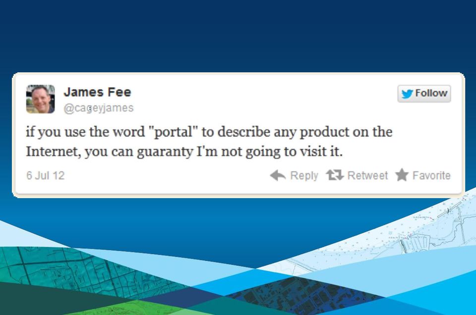
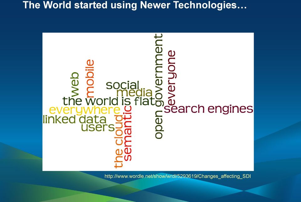
17 The World started using Newer Technologies


18 Go Beyond Metadata Searching Find Features in Feature Services Find Articles in RSS/Atom Feeds Find (Non-)Geospatial (Social) Media (Video, Photo, ) Feature Services Social Media Geonames.org Documents Geodatabase Services THREDDS


19 Gobierno Abierto para algo Recovery.gov Expenditures vs. Need Haiti AID Funding World Bank Projects


20

21 ArcGIS Online
22
23
24
25
26
27 Conclusiones Deseo de compartir geodatos Comunidades distintas todavia: IDE y Popular Esri trata de ofrecer soluciones para ambas Cumplir con estandares: sí, pero para algo Geodatos abiertos: sí, pero para algo Plataformas abiertas: sí, a través de APIs, extensiones

28 Gracias por su atención Espero verles este viernes en la conferencia de usuarios Esri en la UCA
EXPLORING AND SHARING GEOSPATIAL INFORMATION THROUGH MYGDI EXPLORER
 EXPLORING AND SHARING GEOSPATIAL INFORMATION THROUGH MYGDI EXPLORER Subashini Panchanathan Malaysian Centre For Geospatial Data Infrastructure ( MaCGDI ) Ministry of National Resources and Environment
An Esri White Paper June 2011 ArcGIS for INSPIRE
 An Esri White Paper June 2011 ArcGIS for INSPIRE Esri, 380 New York St., Redlands, CA 92373-8100 USA TEL 909-793-2853 FAX 909-793-5953 E-MAIL info@esri.com WEB esri.com Copyright 2011 Esri All rights reserved.
An ESRI White Paper October 2009 ESRI Geoportal Technology
 An ESRI White Paper October 2009 ESRI Geoportal Technology ESRI 380 New York St., Redlands, CA 92373-8100 USA TEL 909-793-2853 FAX 909-793-5953 E-MAIL info@esri.com WEB www.esri.com Copyright 2009 ESRI
GeoNetwork and ESRI GIS Portal Toolkit Comparison
 GeoNetwork and Comparison The following software are being evaluated for the GeoSUR project for the implementation of GIS portal application for the South American region. The information collected for
ArcGIS Web Mapping. Sam Berg, esri sberg@esri.com
 ArcGIS Web Mapping Sam Berg, esri sberg@esri.com Agenda ArcGIS and WebMaps The APIs ArcGIS for Flex Viewer ArcGIS for Silverlight Builder ArcGIS for Sharepoint ArcGIS Application Templates ArcGIS Runtime
Task AR-09-01a Progress and Contributions
 Doug Nebert, POC U.S. Geological Survey ddnebert@usgs.gov March 2010 Task AR-09-01a Progress and Contributions Background and scope for AR-09-01a This Task defines the minimum, common technical capabilities
GeoNetwork, The Open Source Solution for the interoperable management of geospatial metadata
 GeoNetwork, The Open Source Solution for the interoperable management of geospatial metadata Ing. Emanuele Tajariol, GeoSolutions Ing. Simone Giannecchini, GeoSolutions GeoSolutions GeoSolutions GeoNetwork
ArcGIS. Server. A Complete and Integrated Server GIS
 ArcGIS Server A Complete and Integrated Server GIS ArcGIS Server A Complete and Integrated Server GIS ArcGIS Server enables you to distribute maps, models, and tools to others within your organization
Standardized data sharing through an open-source Spatial Data Infrastructure: the Afromaison project
 Standardized data sharing through an open-source Spatial Data Infrastructure: the Afromaison project Yaniss Guigoz - University of Geneva/GRID-Geneva 1 EcoARM2ERA and AFROMAISON Why Afromaison in this
GeoNetwork, The Open Source Solution for the interoperable management of geospatial metadata
 GeoNetwork, The Open Source Solution for the interoperable management of geospatial metadata Ing. Simone Giannecchini, GeoSolutions Ing. Emanuele Tajariol, GeoSolutions Outline GeoNetwork Introduction
ArcGIS 10.1 Web Apps and APIs. John Hasthorpe & Kai Hübner
 ArcGIS 10.1 Web Apps and APIs John Hasthorpe & Kai Hübner Overview Options for leveraging ArcGIS Server using Esri s Web APIs Alternatives to the Web ADF application builder (Gone in 10.1) When and how
Network Analysis with ArcGIS Online
 Federal GIS Conference February 9 10, 2015 Washington, DC Network Analysis with ArcGIS Online Matt Kennedy Topics Online versus on-premise network analysis services How to access online services How to
Enterprise GIS Solutions to GIS Data Dissemination
 Enterprise GIS Solutions to GIS Data Dissemination ESRI International User Conference July 13 17, 2009 Wendy M. Turner Senior GIS Engineer & Program Manager Freedom Consulting Group, LLC Building the Enterprise
ArcGIS Viewer for Silverlight An Introduction
 Esri International User Conference San Diego, California Technical Workshops July 26, 2012 ArcGIS Viewer for Silverlight An Introduction Rich Zwaap Agenda Background Product overview Getting started and
How To Use The Alabama Data Portal
 113 The Alabama Metadata Portal: http://portal.gsa.state.al.us By Philip T. Patterson Geological Survey of Alabama 420 Hackberry Lane P.O. Box 869999 Tuscaloosa, AL 35468-6999 Telephone: (205) 247-3611
SuperGIS Server 3.2 Standard Edition Specification
 SuperGIS Server 3.2 Standard Edition Specification 20140826 Specification 1. All of the services support SOAP (Simple Object Access Protocol). 2. Use map file created by SuperGIS Desktop as map services
EEOS 381 - Spatial Databases and GIS Applications
 EEOS 381 - Spatial Databases and GIS Applications Lecture 9 Metadata What is Metadata? Data about data Description of a (GIS) dataset What it represents Who created it? When? How? Format Field definitions
Enabling embedded maps
 Enabling embedded maps Case: National geoportal of Finland Antti Rainio National Land Survey of Finland Trends: Web Services, Mapping Mashup, Open Source, Open Data Decentralised data s Service interfaces
Welcome to Esri's Software Export Control Classification Number (ECCN) Matrix
 Matrix") Welcome to Esri's Software Export Control Classification Number (ECCN) Matrix Updated September 30, 2015 This portion of the Esri web site is to provide information regarding the export control classification
Welcome to Esri's Software Export Control Classification Number (ECCN) Matrix Updated September 30, 2015 This portion of the Esri web site is to provide information regarding the export control classification
Lecture 8. Online GIS
 Lecture 8 Online GIS Lecture 8: Outline I. Online GIS 1. Google Earth 2. MSN Live Maps II. Open Source GIS III. ArcGIS Server and the ESRI suite of online software utility options IV. Advanced Data Mining
Portal for ArcGIS. Satish Sankaran Robert Kircher
 Portal for ArcGIS Satish Sankaran Robert Kircher ArcGIS A Complete GIS Data Management Planning & Analysis Field Mobility Operational Awareness Constituent Engagement End to End Integration Collect, Organize,
Chapter 1: Introduction to ArcGIS Server
 Chapter 1: Introduction to ArcGIS Server At a high level you can think of ArcGIS Server as software that helps you take your geographic information and make it available to others. This data can be distributed
CDI/THREDDS Interoperability: the SeaDataNet developments. P. Mazzetti 1,2, S. Nativi 1,2, 1. CNR-IMAA; 2. PIN-UNIFI
 CDI/THREDDS Interoperability: the SeaDataNet developments P. Mazzetti 1,2, S. Nativi 1,2, 1. CNR-IMAA; 2. PIN-UNIFI Outline Interoperability Issues in SeaDataNet A broker solution for CDI/THREDDS interoperability
Publishing geospatial data to the web using the EEA infrastructure
 Publishing geospatial data to the web using the EEA infrastructure *Note: Map Services should be published using the EEA Map Services Tick Sheet for guidance. Contact Sebastien Petit (Sebastien.Petit@eea.europa.eu)
ArcGIS Online School Locator
 ArcGIS Online School Locator G-Cloud Services RM 1557vi Service Definition Esri UK G-Cloud 6 Lot 3 SaaS Services Crown Commercial Service Acknowledgement Esri and ArcGIS are trademarks, registered trademarks,
Implementing ArcGIS for SharePoint Habitat for Humanity of Omaha April, 2013
 Ingenuity Innovation Integrity Implementing ArcGIS for SharePoint Habitat for Humanity of Omaha April, 2013 1851 Alexander Bell Drive Suite 350 Reston, VA 20191 703.463.2059 800.483.2434 www.vistronix.com
ArcGIS Framework Plug-In: Extending the ArcGIS Desktop for ANSI Standard Framework Data to Support Government Decision Making
 ArcGIS Framework Plug-In: Extending the ArcGIS Desktop for ANSI Standard Framework Data to Support Government Decision Making Final Project Report October 28, 2008 Agreement Number Organization Project
Vision. South Pacific GIS/RS Conference 2015 11/17/2015. Applying Geography Everywhere. Applying Geography Everywhere
 South Pacific GIS/RS Conference 2015 Applying Geography Everywhere Jithen (J) Singh Eagle Technology Group Ltd (Esri New Zealand) Suva, Fiji Vision Applying Geography Everywhere 1 GIS Is Evolving A Whole
National Geothermal Data System and Global Geosciences Data Integration
 National Geothermal Data System and Global Geosciences Data Integration Lee Allison, AZGS Stephen Richard, AZGS Arlene Anderson, US DOE David Cuyler, US DOE & Sandia Natl Lab NERC 2008 Outline Rational
GeoCloud Status. Doug Nebert June 2011
 GeoCloud Status Doug Nebert June 2011 Platform as a Service Architectural Framework Distinguishing Application, Platform and Infrastructure Applications: 10 identified GeoSpatial instances/servers with
Scholars GeoPortal: Since 2002, Scholars Portal has hosted shared collections...
 Scholars GeoPortal: A New Platform for Geospatial Data Discovery, Exploration and Access in Ontario Universities by Elizabeth Hill and Leanne Trimble 1 OCUL Abstract The need to support and promote the
Five Steps to Better Performance
 Effective Web maps have a specific focus and are designed so users can interact with them to accomplish meaningful tasks. Five Steps to Better Performance Sample methodology for creating a great Web map
NOAA Environmental Data Management
 NOAA Environmental Management Report to EDM Virtual Workshop 2013 06 25 Jeff de La Beaujardière, PhD NOAA Management Architect jeff.delabeaujardiere@noaa.gov +1 301 713 7175 1 NOAA EDM Framework Management
Analysis of the Free GIS Software Applications in respect to INSPIRE services and OGC standards
 Analysis of the Free GIS Software Applications in respect to INSPIRE services and OGC standards Authors: Francesco D'Alesio Peter Hopfgartner Paolo Viskanic June 2011 Executive Summary This document analyses
Mobile Solutions in ArcGIS. Justin Fan
 Mobile Solutions in ArcGIS Justin Fan Agenda Introducing Mobile GIS Esri Mobile GIS solutions Selecting the right Mobile GIS solution Resources Q&A Introducing Mobile GIS What is Mobile GIS? Extends the
Institute of Computational Modeling SB RAS
 Institute of Computational Modeling SB RAS ORGANIZATION OF ACCESS TO OBSERVATIONAL DATA USING WEB SERVICES FOR MONITORING SYSTEMS THE STATE OF THE ENVIRONMENT Kadochnikov Aleksey A. Russia, Krasnoyarsk
Oklahoma s Open Source Spatial Data Clearinghouse: OKMaps
 Oklahoma s Open Source Spatial Data Clearinghouse: OKMaps Presented by: Mike Sharp State Geographic Information Coordinator Oklahoma Office of Geographic Information MAGIC 2014 Symposium April 28-May1,
CatMDEdit Metadata editor
 Advanced Information Systems Laboratory GeoSpatiumLab S.L. CatMDEdit Metadata editor University of Zaragoza Computer Science and Systems Engineering Department Advanced Information Systems Laboratory (IA3)
Methods Examples Govt. Limitations Future Plans
 Tracking Users at a NOAA Data Center Methods Examples Govt. Limitations Future Plans Methods at NGDC Search Domain Organization Daily General Referrer Directory Browser and Query Summary Hourly Report
D.5.2: Metadata catalogue for drought information
 Project start date: 01 May 2009 Acronym: EuroGEOSS Project title: EuroGEOSS, a European Theme: FP7-ENV-2008-1: Environment (including climate change) Theme title: ENV.2008.4.1.1.1: European Environment
Off The Shelf Approach to ArcGIS Server & The Dashboard Approach to Gaining Insight to ArcGIS Server
 Off The Shelf Approach to ArcGIS Server & The Dashboard Approach to Gaining Insight to ArcGIS Server Robert Lenarcic Latitude Geographics rlenarcic@latitudegeo.co AGENDA Out of the box ArcGIS Server web-mapping
Conservation Workshop ArcGIS Explorer
 Conservation Workshop ArcGIS Explorer Bern Szukalski bszukalski@esri.com Topics for this session Introduction Overview of features Using ArcGIS Explorer effectively New features & capabilities Customization
About As. In a team with the best. ESRI Bulgaria is the exclusive distributor of Esri Inc. for Bulgaria. Esri Inc.
 About As ESRI Bulgaria is an IT company, leader in the field of Geographic Information Systems (GIS) on the Bulgarian market. Offering the most advanced high-tech products, solutions and services, ESRI
The Arctic Observing Network and its Data Management Challenges Florence Fetterer (NSIDC/CIRES/CU), James A. Moore (NCAR/EOL), and the CADIS team
, James A. Moore (NCAR/EOL), and the CADIS team") The Arctic Observing Network and its Data Management Challenges Florence Fetterer (NSIDC/CIRES/CU), James A. Moore (NCAR/EOL), and the CADIS team Photo courtesy Andrew Mahoney NSF Vision What is AON? a
The Arctic Observing Network and its Data Management Challenges Florence Fetterer (NSIDC/CIRES/CU), James A. Moore (NCAR/EOL), and the CADIS team Photo courtesy Andrew Mahoney NSF Vision What is AON? a
MD imap 2.0 THE NEXT GENERATION OF MARYLAND S ENTERPRISE GIS. Esri MUG Conference Baltimore, MD December 3, 2014 http://imap.maryland.
 THE NEXT GENERATION OF MARYLAND S ENTERPRISE GIS MD imap 2.0 Matt Sokol, GISP Senior GIS Analyst Maryland Department of Information Technology Geographic Information Office Julia Fischer, GISP Senior GIS
County of Los Angeles. Chief Information Office Preferred Technologies for Geographic Information Systems (GIS) September 2014
 September 2014") County of Los Angeles Chief Information Office Preferred Technologies for Geographic Information Systems (GIS) September 2014 CIO Preferred Technologies for GIS This document lists the preferred Geographic
County of Los Angeles Chief Information Office Preferred Technologies for Geographic Information Systems (GIS) September 2014 CIO Preferred Technologies for GIS This document lists the preferred Geographic
REACCH PNA Data Management Plan
 REACCH PNA Data Management Plan Regional Approaches to Climate Change (REACCH) For Pacific Northwest Agriculture 875 Perimeter Drive MS 2339 Moscow, ID 83844-2339 http://www.reacchpna.org reacch@uidaho.edu
PDOK Kaart, the Dutch Mapping API
 PDOK Kaart, the Dutch Mapping API Haico van der Vegt*, Leo van der Sluijs* * Cadastre, Land Registry and Mapping Agency of the Netherlands Abstract. PDOK (public services on the map) is a partnership of
ERDAS APOLLO 2009. How to manage/catalog/share Raster & vector data. ERDAS, Inc. A Hexagon Company. All Rights Reserved 1
 ERDAS APOLLO 2009 How to manage/catalog/share Raster & vector data ERDAS, Inc. A Hexagon Company. All Rights Reserved 1 Here we are; Again Leica Geosystems Geospatial Imaging is now ERDAS, Inc. ERDAS,
Jiří Kadlec and Daniel P. Ames*
 AWRA 2012 SPRING SPECIALTY CONFERENCE New Orleans, Louisiana March 26 28, 2012 Copyright 2012 AWRA DEVELOPMENT OF A LIGHTWEIGHT HYDROSERVER AND HYDROLOGIC DATA HOSTING WEBSITE Jiří Kadlec and Daniel P.
Intro to Web App Builder. Mark Scott, Solutions Engineer, Esri County Government Team mscott@esri.com
 Intro to Web App Builder Mark Scott, Solutions Engineer, Esri County Government Team mscott@esri.com The ArcGIS Platform enables Web GIS Enabling GIS Everywhere Desktop Web Device Simple Integrated Open
Supporting High-Quality Printing in Web Applications with ArcGIS for Server
 2013 Esri International User Conference July 8 12, 2013 San Diego, California Technical Workshop Supporting High-Quality Printing in Web Applications with ArcGIS for Server Craig Williams Tanu Hoque Esri
How To Use Gis
 Welcome Understanding Purpose Creating Relationships You A Global Community of GIS Professionals Changing the World Together Applying Geography Everywhere Your WORK Showcasing Your Web Apps Vision Applying
Centre for EcologicalNoosphere Studies NAS RA CENS
 SCOPES 2009-2012 Scientific Co-operation between Eastern Europe and Switzerland Accessing Armenian Environmental data through CENS Spatial Data Infrastructure Centre for EcologicalNoosphere Studies NAS
Application Development Using Image Services Web APIs. Hong Xu, Wenxue Ju
 Application Development Using Image Services Web APIs Hong Xu, Wenxue Ju Session Outline Discuss and demonstrate the following image service web application patterns: Display image service in your web
Mapping Mashup/Data Integration Development Resources Teaching with Google Earth and Google Ocean Stone Lab August 13, 2010
 Mapping Mashup/Data Integration Development Resources Teaching with Google Earth and Google Ocean Stone Lab August 13, 2010 David Hart GIS Specialist University of Wisconsin Sea Grant Institute Virtual
Storytelling with Maps: Workflows and Best Practices
 Storytelling with Maps: Workflows and Best Practices Introduction What is a story map? Story maps are interactive maps combined with text and other content to tell a story about the world. Typically story
Making MAGIC with Your Data: Interactive Maps, Map Mashups, and Data Visualization Tools
 Making MAGIC with Your Data: Interactive Maps, Map Mashups, and Data Visualization Tools Michael Howser Connecticut State Data Center Coordinator & Undergraduate Education & GIS Librarian What is the Connecticut
GIS Beyond the Basics: Web Maps and File Sharing Services
 GIS Beyond the Basics: Web Maps and File Sharing Services by Julie Coco, PE I. INTRODUCING WEB-BASED GIS SERVICES A GIS service, or Geoservice, provides a way to retrieve maps, images, or geoprocessing
Best practices building multi-platform apps. John Hasthorpe & Josh Venman
 Best practices building multi-platform apps John Hasthorpe & Josh Venman It s good to have options Android 4.3 10 Tablet Windows 7 14 Laptop Windows 7 15 Laptop Mac OSX 15 Laptop ios 6 4.6 Phone Android
GIS and Mapping Solutions for Developers. ESRI Developer Network (EDN SM)
") GIS and Mapping Solutions for Developers ESRI Developer Network (EDN SM) GIS and Mapping Solutions for Developers If you are a software developer looking for an effective way to bring geographic and mapping
GIS and Mapping Solutions for Developers ESRI Developer Network (EDN SM) GIS and Mapping Solutions for Developers If you are a software developer looking for an effective way to bring geographic and mapping
Urban Planning -794 Internet Geographic Information Systems Fall 2012
 Urban Planning -794 Internet Geographic Information Systems Fall 2012 Instructor: Melissa Mann (mmann@uwm.edu) Manager: Kurt Meingast (kurtm@uwm.edu) Schedule: Class: Monday, 5:30 6:45, SARUP 158 : Monday,
Amazon Hosted ESRI GeoPortal Server. GeoCloud Project Report
 Amazon Hosted ESRI GeoPortal Server GeoCloud Project Report Description of Application Operating Organization The USDA participated in the FY 2011 Federal Geographic Data Committee (FGDC) GeoCloud Sandbox
GEOGRAPHIC INFORMATION GATEWAY New York Department of State (NYDOS) data acceptance & metadata standards
 data acceptance & metadata standards") GEOGRAPHIC INFORMATION GATEWAY New York Department of State (NYDOS) data acceptance & metadata standards 1. DATA ACCEPTANCE STANDARDS The following describes the data acceptance standards for data included
GEOGRAPHIC INFORMATION GATEWAY New York Department of State (NYDOS) data acceptance & metadata standards 1. DATA ACCEPTANCE STANDARDS The following describes the data acceptance standards for data included
MAY 18, 2015 ARCGIS 10.3.1 FOR SERVER FUNCTIONALITY MATRIX
 MAY 18, 2015 ARCGIS 10.3.1 FOR SERVER FUNCTIONALITY MATRIX Copyright 2015 Esri All rights reserved. Printed in the United States of America. The information contained in this document is the exclusive
OSGeo Web Mapping Typification: GeoMajas, Mapbender, MapFish and OpenLayers. Christoph Baudson Arnulf Christl FOSS4G 2010 Barcelona
 OSGeo Web Mapping Typification: GeoMajas, Mapbender, MapFish and OpenLayers Christoph Baudson Arnulf Christl FOSS4G 2010 Barcelona Disclaimer All information contained in this presentation has been compiled
What s new in Carmenta Server 4.2
 What s new in Carmenta Server 4.2 A complete solution for cost-effective visualisation and distribution of GIS data through web services Carmenta Server provides cost-effective technology for building
ArcGIS Platform. An Integrated System. Portal
 Platform An Integrated System Portal An Integrated Web GIS Platform Knowledge Workers Executive Access Public Engagement Work Anywhere Enterprise Integration Providing Mapping, Analysis, Data Management,
http://opendata.comune.fi.it
 The Environmental Observation Web and its Service Applications within the Future Internet OPENDATA IN CITY OF FLORENCE Gianluca Vannuccini Head of the IT Infrastructure Development Office IT Department
Smart Cities require Geospatial Data Providing services to citizens, enterprises, visitors...
 Cloud-based Spatial Data Infrastructures for Smart Cities Geospatial World Forum 2015 Hans Viehmann Product Manager EMEA ORACLE Corporation Smart Cities require Geospatial Data Providing services to citizens,
Videocolaboración en la Nube. Una solución para CUDI
 Videocolaboración en la Nube Una solución para CUDI Agenda 1. Introduction to Cloud Enablement for Video 2. Scopia Product line 3. Design and Deploy 4. Summary 2013 Avaya Inc. All rights reserved. 2 Soluciones
GIS Data Models for INSPIRE and ELF
 GIS Data Models for INSPIRE and ELF Paul Hardy Roberto Lucchi EuroSDR/ELF Copenhagen Data Modelling and Model Driven Implementation of Data Distribution 28 Jan 2015 ArcGIS for INSPIRE Extends ArcGIS for
Guide to Creating and Editing Metadata in ArcGIS for Publishing to the MSDIS GeoPortal
 Guide to Creating and Editing Metadata in ArcGIS for Publishing to the MSDIS GeoPortal 1). Geoportal publishing requirement For the MSDIS GeoPortal to publish your data there is one requirement that each
Web and Mobile GIS Applications Development
 Web and Mobile GIS Applications Development Presented by : Aamir Ali Manager Section Head (GIS Software Customization) Pakistan Space and Upper Atmosphere Research Commission (SUPARCO) Geographical Information
ArcGIS : Engineered for Interoperability
 ArcGIS : Engineered for Interoperability An ESRI White Paper January 2006 ESRI 380 New York St., Redlands, CA 92373 8100, USA TEL 909 793 2853 FAX 909 793 5953 E MAIL info@esri.com WEB www.esri.com Copyright
EBONE. European Biodiversity Observation Network: Design of a plan for an integrated biodiversity observing system in space and time
 EBONE European Biodiversity Observation Network: Design of a plan for an integrated biodiversity observing system in space and time D7.2: Tested web portal for data access based on technical and functional
Leveraging Cloud-Based Mapping Solutions
 Leveraging Cloud-Based Mapping Solutions GeoAlberta October 28, 2014 Laura Kerssens Safe Software Agenda To the Cloud Using Basic Services Cloud Applications Web Services Cloud-Hosted Databases Real-time
Spatial Data Infrastructures - trends and impacts on society. Max Craglia Joint Research Centre Digital Earth and Reference Data Unit
 Spatial Data Infrastructures - trends and impacts on society Max Craglia Joint Research Centre Digital Earth and Reference Data Unit Outline Where we were 20 years ago Where we are now Where we are going
An ESRI White Paper July 2009 Creating and Maintaining a Geoportal Management Considerations
 An ESRI White Paper July 2009 Creating and Maintaining a Geoportal Management Considerations ESRI 380 New York St., Redlands, CA 92373-8100 USA TEL 909-793-2853 FAX 909-793-5953 E-MAIL info@esri.com WEB
NATIONAL CLIMATE CHANGE & WILDLIFE SCIENCE CENTER & CLIMATE SCIENCE CENTERS DATA MANAGEMENT PLAN GUIDANCE
 NATIONAL CLIMATE CHANGE & WILDLIFE SCIENCE CENTER & CLIMATE SCIENCE CENTERS DATA MANAGEMENT PLAN GUIDANCE Prepared by: NCCWSC/CSC Data Management Working Group US Geological Survey February 26, 2013 Version
ArcGIS Web App Builder (AWAB) In BETA. John Bocan MES/DoIT john.bocan@maryland.gov
 In BETA. John Bocan MES/DoIT john.bocan@maryland.gov") ArcGIS Web App Builder (AWAB) In BETA John Bocan MES/DoIT john.bocan@maryland.gov Some Facts (1 slide) The Pros (5 slides) The Cons (2 slides) Some Bugs/Issues (1 slide) What s to Come (1 slide) What This
ArcGIS Web App Builder (AWAB) In BETA John Bocan MES/DoIT john.bocan@maryland.gov Some Facts (1 slide) The Pros (5 slides) The Cons (2 slides) Some Bugs/Issues (1 slide) What s to Come (1 slide) What This
Activities for IBM Industry Forum 2010
 Activities for IBM Industry Forum 2010 Facebook Event. LinkedIn Event. developerworks blog entry. Twitter posts. Page 1 Social Media traffic contribution dw mailings peak (among other possible factors)
Open Data. Open Data. Share and map your data with ArcGIS. technology.
 Open Data Share and map your data with ArcGIS Open Data technology. Publishing data as map services is one of the most valuable ways to communicate and collaborate. Maps enable an immediate understanding
Introduction to Web AppBuilder for ArcGIS: JavaScript Apps Made Easy
 Introduction to Web AppBuilder for ArcGIS: JavaScript Apps Made Easy OKSCAUG Pamela Kersh September 22, 2015 The ArcGIS Platform enables Web GIS Enabling GIS Everywhere Desktop Web Device Simple Integrated
MyOcean Copernicus Marine Service Architecture and data access Experience
 MyOcean Copernicus Marine Service Architecture and data access Experience Sophie Besnard CLS, Toulouse, France February 2015 MyOcean Story MyOcean Challenge & Success MyOcean Service MyOcean System MyOcean
The ORIENTGATE data platform
 Seminar on Proposed and Revised set of indicators June 4-5, 2014 - Belgrade (Serbia) The ORIENTGATE data platform WP2, Action 2.4 Alessandra Nuzzo, Sandro Fiore, Giovanni Aloisio Scientific Computing and
The Importance of Data Quality in your Enterprise
 Federal GIS Conference February 9 10, 2015 Washington, DC The Importance of Data Quality in your Enterprise Heather Murnane & Sherry Fagin Workshop Agenda Importance of Data Quality What is ArcGIS Data
How To Install The Arcgis For Inspire Server Extension On A Microsoft Gis For Inspire Server Extension (For Microsoft) On A Pc Or Macbook Or Ipa (For Macbook)
 On A Pc Or Macbook Or Ipa (For Macbook)") ArcGIS 10.2.1 for INSPIRE Server Extension Installation Guide Content 1 Introduction... 1 2 System Requirements... 1 3 Installation... 1 4 Software Authorization... 2 5 Changes to the System... 2 6 Performance
ArcGIS 10.2.1 for INSPIRE Server Extension Installation Guide Content 1 Introduction... 1 2 System Requirements... 1 3 Installation... 1 4 Software Authorization... 2 5 Changes to the System... 2 6 Performance
Introduction to Geospatial Web Services
 Geospatial Web Services Introduction to Geospatial Web Services An introduction and inventory of geospatial web services and their importance to interoperability in the geospatial domain. vers. 20100604
Appendix E: Data Sharing Platforms Introduction and Examples
 Appendix E: Data Sharing Platforms Introduction and Examples The following introduction of data sharing platforms is intended to provdie the Regional Data Advisory Committee and staff with an overview
GeoManitoba Spatial Data Infrastructure Update. Presented by: Jim Aberdeen Shawn Cruise
 GeoManitoba Spatial Data Infrastructure Update Presented by: Jim Aberdeen Shawn Cruise Organization Overview Manitoba Innovation Energy and Mines Business Transformation and Technology (BTT) Application
Evolving Infrastructure: Growth and Evolution of Spatial Portals
 Evolving Infrastructure: Growth and Evolution of Spatial Portals Jeanne FOUST, USA, Winnie S.M. TANG, Hong Kong SAR, China and Jan SELWOOD, Japan Key words: GIS, Global, Spatial Infrastructures, Internet/Web,
FGDC, Meet the DDI. Adding Geospatial Metadata to a Numeric Data Catalog. Julie Linden Yale University
 FGDC, Meet the DDI Adding Geospatial Metadata to a Numeric Data Catalog Julie Linden Yale University Outline StatCat: numeric data catalog Why add geospatial metadata? FGDC/DDI crosswalk Implementation
Network Analysis with Python. Deelesh Mandloi
 Deelesh Mandloi Slides and code samples from this demo theater http://esriurl.com/uc15nawpy Topics ArcGIS Network Analyst extension and concepts Network analysis using ArcGIS Online Network analysis using
Network Analysis with ArcGIS for Server
 Esri International User Conference San Diego, California Technical Workshops July 24, 2012 Network Analysis with ArcGIS for Server Deelesh Mandloi Dmitry Kudinov Introduction Who are we? - Network Analyst
Documentation of open source GIS/RS software projects
 Contract no. Workpackage Delivery Delivery Date 030776 WP1 D1.6 2007-07-02 CASCADOSS Development of a trans-national cascade training programme on Open Source GIS&RS Software for environmental applications
GetLOD - Linked Open Data and Spatial Data Infrastructures
 GetLOD - Linked Open Data and Spatial Data Infrastructures W3C Linked Open Data LOD2014 Roma, 20-21 February 2014 Stefano Pezzi, Massimo Zotti, Giovanni Ciardi, Massimo Fustini Agenda Context Geoportal
HELCOM Data and Map Service. User Manual
 HELCOM Data and Map Service User Manual Version 2.2 - February 2015 1 Table of contents 1. General Information... 3 1.1 Background... 3 1.2 Technical requirements... 3 1.3 Contact... 3 2. Accessing HELCOM
Content. What is Metadata Design and Thing Catalogs INSPIRE and digital Geo Data New Requirement: Pragmatics...and the w holy REST.
 Download: http://arnulf.us/publications/the potential of metadata_foss4g 2010.odp http://arnulf.us/publications/the potential of metadata_foss4g 2010.pdf Content Arnulf Christl What is Metadata Design
INSPIRE Dashboard. Technical scenario
 INSPIRE Dashboard Technical scenario Technical scenarios #1 : GeoNetwork catalogue (include CSW harvester) + custom dashboard #2 : SOLR + Banana dashboard + CSW harvester #3 : EU GeoPortal +? #4 :? + EEA