West London Dyke Flood Control Structure Master Plan Appendix A
|
|
|
- Miles Hodge
- 9 years ago
- Views:
Transcription
1 West London Dyke Flood Control Structure Master Plan Appendix A

2 Introduction The West London Dyke runs along the west bank of the North Branch of the Thames River from Oxford Street to the forks of the Thames River and then along the west bank of the main branch to the west of the Wharncliffe Road Bridge. Construction began on the West London Dyke in the 19 th century in order to minimize flood damage in the West London area which was prone to flooding. Historical records indicate that portions of the earth embankments which form the underlying support of the current dyke structure generally consists of material deposited from street sweepings and excess soil from excavation work. Fig 1 Photo from the 1930 s showing the concrete Dyke being formed. Beginning in the mid 1910 s, the City began to undertake reconstruction of the dyke system to include additional placement of fill and a concrete facing as a means of additional protection against erosion. However, it wasn t until after the 1937 flood that the present concrete facing material was placed. The City of London owns the dyke structure and undertakes minor maintenance activities. Through an agreement with the Upper Thames River Conservation Authority (UTRCA), the UTRCA undertakes major maintenance activities. Background In 2004, Stantec Consulting Ltd. undertook a condition assessment of flood control structures within the City of London including the West London Dyke. Approximately 350 m of the dyke structure from the Queens Avenue Bridge to Rogers Avenue was identified as being the highest priority for repair. In April 2005, Stantec undertook an investigation to determine the requirements to repair this area of the dyke. Based on the investigation that included coring of the structure and geotechnical review by a soils consultant, it was concluded that this section of the dyke has come to the end of its useful life. Therefore, it needs to be replaced rather than repaired. Page 1


 and the 1:100 year flood event.")
3 General Information Existing Structure - The current dyke can generally be described as a gravity structure consisting of earth fill with a poured in place concrete facing supported by a concrete toe. Large precast concrete blocks are also located along sections of the toe within the river to add additional support and to minimize erosion. Fig 2 Typical cross section of the existing West London Dyke in the study area Current Flood Protection -The section in the study area at present provides the lowest level of flood protection compared to other portions of the West London Dyke. In general, the elevation of the dyke is between the Regulatory Flood Line (1:250 year flood) and the 1:100 year flood event. On average, the structure is approximately 0.7 m below the Regulatory Flood Line within the project area. Page 2
 and the 1:100 year flood event.")
4 Preliminary Engineering Major Design Considerations Provide flood protection to at least the 1:100 year flood level as presently provided and if practical/economical to the 1:250 year flood level; Minimize impacts on environment (therefore replacement structure is to be within the existing dyke footprint); Provide a design that can work in restricted areas of the dyke within project area and in other segments of the West London Dyke requiring future replacement; Given the cost, complexity and potential inconveniences during construction, the major components of the replacement dyke structure should be designed for a life expectancy of 75 years; Maintain/enhance recreational use of the dyke; Incorporate a pathway structure from the bottom of the Queens Avenue Bridge to the top of the dyke structure; and Given the high visibility of the structure and its proximity to the downtown core, aesthetics to be considered in the selection of the preferred structure. Design Alternatives for Replacement of the Dyke - A tabular decision matrix listing the various options for replacement of the dyke structure was prepared (see display board). In total, eleven (11) design alternatives were submitted for review by the City and UTRCA. Based on the decision matrix developed four alternatives were shortlisted for further review. These are: Option A: Pre-cast reinforced earth system; Page 3

5 Option B: Reinforced concrete cantilever wall (retaining wall); Option C: Pre-cast concrete Revetment; and Option D: Pre-cast concrete modular block structure. Page 4

6 Shortlisted Design Option Review - The following were considered in undertaking a comparative analysis of the shortlisted options: Capital Cost; Aesthetics; Function (including the potential to integrate a pedestrian pathway from beneath the bridges to the top of dyke); Constructability; and Durability. Table 1 summarizes the rankings for the shortlisted options: Table 1 Ranking of Options OPTION A B C D Weight Construction Cost* $2,100,000 $2,900,000 $4,200,000 $2,500,000 * Based upon a structure to meet the 1:100 year flood Cost ** Aesthetics Function Constructability Durability Total Score Ranking ** Ranking based on inverse ratio of the cost of option divided by the lowest cost option. 1:100 year used as basis as Option C cannot be built to 1:250 year. Option A was selected as the preferred alternative design by the City of London and UTRCA as it best met the requirements for the project, including consideration for cost, provision of adequate pathway integration, aesthetics, ability to provide either the 100 or 250 year flood level and general constructability issues given the site constraints previously identified. The City of London and UTRCA have decided to have the dyke built to the 250 year flood level. Other Considerations Pathway Integration - The City is considering providing a pedestrian connection along the west bank of the Thames River in order to minimize pedestrian crossings of Queens Avenue and Riverside Drive in this area. Two options (continuous and zigzag) were developed to integrate a pathway from beneath the Queens Avenue Bridge to the top of the dyke. The continuous pathway was selected as the preferred design. The final decision on the pathway will be based upon funding availability and subject to additional investigation to determine the integration of the pathway in the vicinity of the bridge supports and to work completed as part of the Phase IV of the Forks of the Thames Phase Revitalization Project. Page 5

7 Class Environmental Assessment - This project falls under the jurisdiction of the Municipal Class Environmental Assessment, Municipal Engineers Association June 2000 process, as the City of London is the Proponent. The project falls under the category of a Municipal Water and Wastewater Project; as a Stormwater Management Project. Based upon a review of the project schedules, this project should be considered a Schedule A (pre-approved) project. This schedule best fits with this project s work scope which is to replace approximately 350 m of the West London Dyke as it has come to the end of its useful life and needs to be replaced rather than repaired. Approvals - This project may require various permits from local, provincial and federal agencies. Verification as to the required approvals will be subject to the completion of detailed design. Total Project Cost The project cost estimate to complete this project is presented in Table 2. This includes replacement to the 1:250 protection level and the inclusion of the pedestrian pathway (in the project area). Table 2 Project Cost Estimate Description Replacement Dyke Pedestrian Pathway Total Construction (1:250 year protection) $2,300,000 $220,000 $2,520,000 Detailed Design & Contract $241, $23, $151,200 Administration (10.5% of Construction) Soils and Material Testing (1% of $23, $2, $25,200 Construction) Subtotal $2,564,500 $245,300 $2,809,800 Contingency (20% of Subtotal) $512,900 $512,900 $561,960 Total $3,077,400 $294, $3,371,760 Comments Comments are welcome and may be directed to: Rick Goldt, C.E.T. Supervisor, Water Control Structures Upper Thames River Conservation Authority 1424 Clarke Rd. London ON N5V 5B9 Tel: (519) x244 Fax: (519) [email protected] Scott Mathers, B. A. Sc., (Eng) Wastewater and Drainage Engineering Environmental and Engineering Services Department, City of London 300 Dufferin St., Room 910 London, ON N6A 4L9 Tel: (519) x5472 Fax: (519) [email protected] Page 6

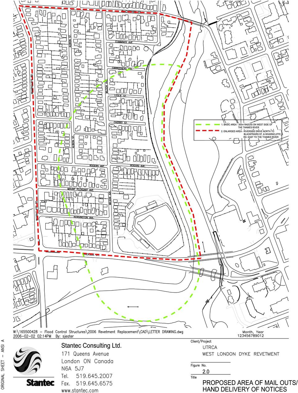
8 THE CORPORATION OF THE CITY OF LONDON UPPER THAMES RIVER CONSERVATION AUTHORITY NOTICE OF PUBLIC INFORMATION CENTRE The West London Dyke is 2374 m long and runs along the west bank of the North Branch of the Thames River from Oxford Street to the forks of the Thames River and then along the west bank of the main branch to the west side of the Wharncliffe Road Bridge. The City of London owns the dyke and through an agreement, the Upper Thames River Conservation Authority (UTRCA) undertakes major maintenance activities. In 2004, the UTRCA undertook a condition assessment of Thames River dykes within the City including the West London Dyke. Approximately 350 m of the dyke north from the Queens Avenue Bridge were identified as being the highest priority for repair. This portion was originally built in the 19 th century in order to minimize flood damage in the West London area with the present concrete revetment dating to the 1930s. In 2005 while undertaking the initial stages of a concrete repair program on this section, the UTRCA and the City concluded that a significant portion of this section had come to the end of its useful life and needed to be replaced rather than repaired. Therefore, a preliminary design report was undertaken by an engineering consultant to assist the City and the UTRCA to determine: The requirements for the performance of a replacement structure; The required life expectancy of the replacement structure; and The recommended replacement structure to be used. The City and the UTRCA have received a draft preliminary design report and based on its findings have arranged for a Public Information Centre. This event is an opportunity for interested persons to learn more about this project and to provide input and comment to the City and the UTRCA. The Public Information Centre details are as follows: Date: Thursday May 25, 2006 Time: 4:30 8:30 p.m. Location: Kiwanis Community Centre, 78 Riverside Drive Inquiries are welcome and may be directed to: Rick Goldt, C.E.T. Supervisor, Water Control Structures Upper Thames River Conservation Authority 1424 Clarke Rd. London ON N5V 5B9 Scott Mathers, B. A. Sc., (Eng) Wastewater and Drainage Engineering Environmental and Engineering Services Department, City of London 300 Dufferin St., Room 910 London, ON N6A 4L9 Tel: (519) x244 Tel: (519) x5472 Fax: (519) Fax: (519)

9
10 Send PIC Notice to: Martyn Curtis, Fish Habitat Biologist Department of Fisheries and Oceans 201 N. Front Street, Suite 703 Sarnia, ON N7T 8B1 Suzanne Shea, Navigable Waters Protection Officer Transport Canada Marine 201 N. Front Street, Suite 703 Sarnia, ON N7T 8B1 Neal Ferris Ministry of Citizenship, Culture & Recreation Archaeology & Heritage Planning 659 Exeter Road London, ON N6E 1L3 Dan Elliott Area Supervisor/Officer in Charge Aylmer District Ministry of Natural Resources 353 Talbot Street West Ron Griffiths, Environmental Assessment Coordinator Ministry of Environment 2 nd Floor 733 Exeter Road LONDON, Ontario N6E 1L3 Erick Boyd, Municipal/Planning Advisor Ministry of Municipal Affairs and Housing Regional Operations Branch 2 nd Floor 659 Exeter Road London, ON N6E 1L3 Allan Van Damme, Manager of Engineering London Hydro Inc. 111 Horton Street London, ON N6A 4H6

11 West London Dykes May 16, 2006 Information Centre Notice sent to the following organizations: Advisory Committee on the Environment, City of London Carolinian Canada Ducks Unlimited, London Chapter Environmental and Ecological Planning Advisory Committee, City of London Friends of Oxbow Creek Friends of Sifton Bog Friends of the Coves Friends of Dingman Creek Global Action Plan for the Earth London Canoe Club London Sport Fishery Association Limited McIlwraith Field Naturalists Middlesex Western Rowing Club Natural Outdoor Activity Heritage Conservation Club Ontario Federation of Anglers and Hunters, Zone J Thames Region Ecological Association Thames River Anglers Association Thames Valley Trail Association Tri County Bass Masters Urban League of London Western Ontario Fish and Game Protective Association

The purpose of this meeting is to inform the public of the updates to the project, and to get input before the finalization of the project.
 The purpose of this meeting is inform the public of the updates the project, and get input before the finalization of the project. The following panels describe the purpose and hisry of the project, along
CHAIR AND MEMBERS CIVIC WORKS COMMITTEE MEETING ON JUNE 8, 2016
 TO: FROM: SUBJECT: CHAIR AND MEMBERS CIVIC WORKS COMMITTEE MEETING ON JUNE 8, 2016 JOHN BRAAM, P. Eng. MANAGING DIRECTOR, ENVIRONMENTAL & ENGINEERING SERVICES & CITY ENGINEER APPOINTMENT OF CONSULTING
5 ALTERNATIVE SOLUTIONS AND EVALUATION
 Page 23 5 ALTERNATIVE SOLUTIONS AND EVALUATION The process used for the assessment and evaluation of the alternatives follows the procedures of the Municipal Class EA, as described below: Identify a reasonable
Bowmanville Marsh Habitat Restoration and Public Access Project
 Bowmanville Marsh Habitat Restoration and Public Access Project Terms of Reference for Detailed and Conceptual Design Works December 2015 1.0 Background and Purpose The Bowmanville Marsh Habitat Restoration
City of London Climate Change Adaptation Strategy Dealing with Extreme Rainfall Events
 City of London Climate Change Adaptation Strategy Dealing with Extreme Rainfall Events May 29, 2014 Presented by: Berta Krichker M.Eng., FEC, P.Eng. Manager of Stormwater Unit Environmental and Engineering
Interim Technical Guidelines for the Development of Environmental Management Plans for Underground Infrastructure Revised - July 2013.
 Interim Technical Guidelines for the Development of Environmental Management Plans for Underground Infrastructure Revised - July 2013 Rationale Underground infrastructure may be at risk from valley, streambank
How To Protect A Floodplain From Flooding
 EXECUTIVE SUMMARY This Class Environmental Assessment (Class EA) was undertaken to examine alternative flood protection systems, and their environmental effects, for the elimination of the flood risk on
Sims Bayou Federal Flood Damage Reduction Project
 Sims Bayou Federal Flood Damage Reduction Project A. Gene Rushing, Jr., P.E., PMP HCFCD Project Manager January 15, 2014 Harris County s Watersheds Historical Flooding in Harris County 1929 1935 HCFCD
Arkansas River Corridor Vision & Master Plan
 A r k a n s a s R I v e r C o r r I d o r P l a n Arkansas River Corridor Vision & Master Plan July 2005 Indian Nations Council of Governments A r k a n s a s R I v e r C o r r I d o r P l a n Partnership
March 2008. Prepared by: Irvine Ranch Water District. 15600 Sand Canyon Avenue. Irvine, CA 92618. Contact: Natalie Likens (949) 453-5633
 453-5633") ADDENDUM TO THE MICHELSON WATER RECLAMATION PLANT PHASE 2 & 3 CAPACITY EXPANSION PROJECT FEBRUARY 2006 FINAL ENVIRONMENTAL IMPACT REPORT AND THE SAN JOAQUIN FRESHWATER MARSH ENHANCEMENT PLAN REVISED SEPTEMBER
ADDENDUM TO THE MICHELSON WATER RECLAMATION PLANT PHASE 2 & 3 CAPACITY EXPANSION PROJECT FEBRUARY 2006 FINAL ENVIRONMENTAL IMPACT REPORT AND THE SAN JOAQUIN FRESHWATER MARSH ENHANCEMENT PLAN REVISED SEPTEMBER
PUBLIC NOTICE Application for Permit
 PUBLIC NOTICE Application for Permit 30-Day Notice Issue Date: June 20, 2016 Expiration Date: July 20, 2016 US Army Corps of Engineers No: NWP-2010-535 Oregon Department of State Lands No: 58311-RF Interested
Preparing, Reviewing and Using Class Environmental Assessments in Ontario
 Code of Practice Preparing, Reviewing and Using Class Environmental Assessments in Ontario Legislative Authority: Environmental Assessment Act, RSO 1990, chapter E.18 January 2014 This Code of Practice
Safe & Sound Bridge Terminology
 Safe & Sound Bridge Terminology Abutment A retaining wall supporting the ends of a bridge, and, in general, retaining or supporting the approach embankment. Approach The part of the bridge that carries
Ross River Suspension Bridge Ross River, Yukon. Life Cycle Cost Analysis
 DNA project managers planners architects engineers David Nairne + Associates Ltd Suite 250 171 W Esplanade North Vancouver British Columbia Canada V7M 3J9 T 604 984 3503 F 604 984 0627 E dna@ davidnairne.com
MINUTES OF THE MEETING OF THE CATFISH CREEK CONSERVATION AUTHORITY
 MINUTES OF THE MEETING OF THE CATFISH CREEK CONSERVATION AUTHORITY Thursday, March 5 th, 2015 Meeting #02/2015 PRESENT: Sally Martyn Chairperson Municipality of Central Elgin Arthur Oslach Vice-Chairperson
STAFF REPORT TO COMMITTEE OF THE WHOLE
 STAFF REPORT TO COMMITTEE OF THE WHOLE DATE: November 7 2012 TO: FROM: SUBJECT: ATTACHMENT(S): COMMITTEE OF THE WHOLE GINA LAYTE-LISTON, SUPERVISOR, WASTEWATER Stormwater Management Funding Strategy None
BRIDGES ARE relatively expensive but often are
 Chapter 10 Bridges Chapter 10 Bridges Bridg Bridges -- usually the best, but most expensive drainage crossing structure. Protect bridges against scour. BRIDGES ARE relatively expensive but often are the
APPLICATION PROCEDURES FOR PLACEMENT OF UNDERGROUND TELECOMMUNICATION CABLES IN THE VICINITY OF TRANSPORTATION FACILITIES
 APPLICATION PROCEDURES FOR PLACEMENT OF UNDERGROUND TELECOMMUNICATION CABLES IN THE VICINITY OF TRANSPORTATION FACILITIES UNDER THE JURISDICTION OF ALBERTA TRANSPORTATION 1.0 Application Procedures 2.0
Nipigon Bay. Area of Concern Status of Beneficial Use Impairments September 2010
 Nipigon Bay Area of Concern Status of Beneficial Use Impairments September 2010 Nipigon Bay is in the most northerly area of Lake Superior. The Area of Concern takes in a large portion of Nipigon Bay and
APPENDIX C LIST OF EA RECIPIENTS
 APPENDIX C APPENDIX C LIST OF RECIPIENTS C.1 Federal Agencies Advisory Council on Historic Preservation, Office of Cultural Resources Preservation U.S. Army Corps of Engineers, District Engineer, Regulatory
In addition to the terms defined in this By-law, the following terms shall have the corresponding meanings for the purposes of this Section:
 Click here to access definitions SECTION 12 FLOODPLAIN LANDS 12.1 INTERPRETATION In addition to the terms defined in this By-law, the following terms shall have the corresponding meanings for the purposes
Vermont Economic Resiliency Initiative (VERI) Community Forum Barre City & Barre Town
 Community Forum Barre City & Barre Town") Vermont Economic Resiliency Initiative (VERI) Community Forum Barre City & Barre Town MEETING NOTES April 16, 2015 6:00 8:00 PM VERI Project Overview With funding from the US Economic Development Administration
Vermont Economic Resiliency Initiative (VERI) Community Forum Barre City & Barre Town MEETING NOTES April 16, 2015 6:00 8:00 PM VERI Project Overview With funding from the US Economic Development Administration
COUNTY OF LAMBTON OFFICIAL PLAN UPDATE BACKGROUND REPORT NO.
 COUNTY OF LAMBTON OFFICIAL PLAN UPDATE BACKGROUND REPORT NO. 6 RENEWABLE ENERGY Image Source: (Word Clip Art Stock Photo, 2011) Date: May, 2015 BACKGROUND PLANNING AND DEVELOPMENT SERVICES DEPARTMENT 789
US Army Corps of Engineers BUILDING STRONG
 Fort Worth District Public Meeting 20 August 2013 US Army Corps of Engineers Lewisville Dam - Authorization Authorized by the River and Harbor Act, approved 2 March 1945 (Public Law 14, 79th Congress,
Full Authority Minutes March 18, 2015
 Full Authority Minutes March 18, 2015 A meeting of the Full Authority of the Kettle Creek Conservation Authority was held on Wednesday, March 18, 2015 at 10:00 a.m. at the Administration Centre. Members
Green Spaces to Improve Waterways and Communities
 Green Spaces to Improve Waterways and Communities Thomas M. Evans, ASLA LEED AP Green Infrastructure Design Services Director Cleveland, Ohio Northern Michigan Green Infrastructure Conference June 4, 2015
Attachment 1 CARRUTHERS CREEK FLOOD MANAGEMENT and ANALYSIS DRAFT TERMS OF REFERENCE
 1.0 INTRODUCTION In early 2010, the Town of Ajax was provided with updated floodplain mapping for Carruthers Creek, based on a Regional Storm event (i.e., Hurricane Hazel), prepared by the Toronto and
Executive Director, Engineering & Construction Services Director, Purchasing & Materials Management Division
 PW8.5 STAFF REPORT ACTION REQUIRED Contract Award Request for Proposal No. 9117-15-7122 Engineering Services for the Detailed Design, Services During Construction, and Post-Construction Services for an
SOME COMMON QUESTIONS ABOUT FLOODPROOFING
 SOME COMMON QUESTIONS ABOUT FLOODPROOFING WHEN DOES FLOODING OCCUR? Although flooding can occur at any time of the year, the risks of high floods are greatest in the spring and summer. Spring floods are
Guide for the Management of Archaeological Resources. National Capital Commission February 2008
 Guide for the Management of Archaeological Resources National Capital Commission February 2008 1 Ce document est aussi disponible en français. National Capital Commission 202 40 Elgin Street Ottawa, Canada
30-DAY PUBLIC NOTICE CHELSEA RIVER, EAST BOSTON MASSACHUSETTS EMERGENCY STREAMBANK PROTECTION PROJECT
 PUBLIC NOTICE Engineering/Planning 696 Virginia Road Concord, MA 01742 Date: 10 November, 2015 Comment Period Ends: 10 December, 2015 In Reply, Refer To: Robert Russo Or by e-mail: [email protected]
Stouffville Corridor Rail Service Expansion
 Stouffville Corridor Rail Service Expansion Stouffville Corridor Rail Service Expansion Class Environmental Assessment Study WELCOME PUBLIC INFORMATION CENTRE #2 Tuesday January 28, 2014 Agincourt Recreation
Frederick. Frederick. Maryland. Smart Growth Successes. Frederick. Maryland Department of Planning
 Frederick Frederick Maryland Smart Growth Successes Frederick Maryland Department of Planning Smart, Green & Growing Martin O Malley Governor Anthony G. Brown Lt. Governor Maryland Department of Planning
Position Statement regarding Offshore Wind Proposals on Lake Huron. Lake Huron Centre for Coastal Conservation
 Position Statement regarding Offshore Wind Proposals on Lake Huron Lake Huron Centre for Coastal Conservation June 2010 Lake Huron Centre for Coastal Conservation (LHCCC) Corporate Position related to:
Bolton Resource Management Tract Management Plan TRCA Delegation to Town of Caledon Council. July 8, 2014
 Bolton Resource Management Tract Management Plan TRCA Delegation to Town of Caledon Council July 8, 2014 TRCA AUTHORITY MEETING #6/13: THAT the draft Bolton Resource Management Tract Management Plan dated
DRAFT SOUTH FORK SKYKOMISH RIVER
 DRAFT SOUTH FORK SKYKOMISH RIVER 9 levees and revetments / Approximately 1.1 miles of river bank are armored Revetments provide limited, localized erosion protection, but impact habitat Frequent and costly
BEFORE THE PHILADELPHIA WATER, SEWER AND STORMWATER RATE BOARD DIRECT TESTIMONY OF STEPHEN J. FURTEK
 BEFORE THE PHILADELPHIA WATER, SEWER AND STORMWATER RATE BOARD Re Application of the Philadelphia Water Department for Increased Rates and Related Charges Fiscal Years 2017-2018 DIRECT TESTIMONY OF STEPHEN
A VISIONARY OFFICE LEASING OPPORTUNITY
 London - Feel The Energy A VISIONARY OFFICE LEASING OPPORTUNITY LONDON S FIRST NET-ZERO BUILDING 60,000 - DESIGNATED MIXED-USE MIKE RIFFEL 519.434.1000 [email protected] Sifton.com THIS WILL CHANGE
Newsletter Jumbo Glacier Alpine Resort Proposal
 Newsletter Jumbo Glacier Alpine Resort Proposal August 1995 - Number 1 - Environmental Assessment Office Province of British Columbia The Jumbo Glacier Alpine Resort Proposal Pheidias Project Management
ArcGIS Model Build. ArcGIS Geodatabase. Brian Beckett (Inland Fisheries Ireland) and Dr. Sally Cook (Supervisor, University of Ulster, Coleraine)
 and Dr. Sally Cook (Supervisor, University of Ulster, Coleraine)") An evaluation of GIS for the predictive modelling and mapping of specific stream power, substratum particle size and potential juvenile lamprey habitat Brian Beckett (Inland Fisheries Ireland) and Dr.
An evaluation of GIS for the predictive modelling and mapping of specific stream power, substratum particle size and potential juvenile lamprey habitat Brian Beckett (Inland Fisheries Ireland) and Dr.
Jackson Gulch Outlet Canal Rehabilitation Project
 Jackson Gulch Outlet Canal Rehabilitation Project Preliminary Budgetary Estimate for Rehabilitation February 2004 Prepared for the Mancos Water Conservancy District Jackson Gulch Reservoir 42888 County
Statement of Qualifications for Natural Resource Management Services October 2014
 Statement of Qualifications for Natural Resource Management Services October 2014 Prepared By: Michael Zenthoefer Point Environmental LLC 911 N Birch ST Canby, OR 97013 541 207 8441 [email protected]
A Green Sector Overview
 A Green Sector Overview Micro Hydro Electric Power Ontario's Waterpower Resources: Past and Present The first hydroelectric generator in Canada was installed near Ottawa, which was the first city in North
Consolidated I&T Data Centre - P3 Canada Fund
 STAFF REPORT ACTION REQUIRED Consolidated I&T Data Centre - P3 Canada Fund Date: January 16, 2012 To: From: Wards: Reference Number: Government Management Committee Deputy City Manager & Chief Financial
1. RECOMMENDATIONS. It is recommended that:
 Clause No. 7 in Report No. 3 of was adopted, without amendment, by the Council of The Regional Municipality of York at its meeting held on February 20, 2014. (Mayor Hackson declared an interest in this
FOUR RIVERS RESTORATION PROJECT
 MLTM Republic of Korea Making Every Drop Count International Workshop on Integrated Urban Water Management WATER & GREEN GROWTH FOUR RIVERS RESTORATION PROJECT Office of National River Restoration, Korea
ACCESS TO JUSTICE: TOOLS OF THE TRADE. Copyright January 2004 Margaret Capes, Community Law School (Sarnia-Lambton) Inc.
 Inc.") ACCESS TO JUSTICE: TOOLS OF THE TRADE Copyright January 2004 Margaret Capes, Community Law School (Sarnia-Lambton) Inc. In cooperation with Victim Services of Sarnia-Lambton and the Ministry of the Attorney
ACCESS TO JUSTICE: TOOLS OF THE TRADE Copyright January 2004 Margaret Capes, Community Law School (Sarnia-Lambton) Inc. In cooperation with Victim Services of Sarnia-Lambton and the Ministry of the Attorney
Emergency Flood Damage Reduction Program April 2013 (revised) Program Profile
 Program Profile") Emergency Flood Damage Reduction Program April 2013 (revised) Program Profile Purpose The Emergency Flood Damage Reduction program (EFDRP) provides assistance with the implementation of emergency flood
Emergency Flood Damage Reduction Program April 2013 (revised) Program Profile Purpose The Emergency Flood Damage Reduction program (EFDRP) provides assistance with the implementation of emergency flood
Background Information: The Mamquam River Floodplain Restoration Project
 Background Information: The Mamquam River Floodplain Restoration Project The Mamquam River Floodplain Restoration project is being undertaken in partnership with the Squamish River Watershed Society, Fisheries
2010 Salida Community Priorities Survey Summary Results
 SURVEY BACKGROUND The 2010 Salida Community Priorities Survey was distributed in September in an effort to obtain feedback about the level of support for various priorities identified in the draft Comprehensive
BRIDGE RESTORATION AND LANDSLIDE CORRECTION USING STRUCTURAL PIER AND GRADE BEAM
 BRIDGE RESTORATION AND LANDSLIDE CORRECTION USING STRUCTURAL PIER AND GRADE BEAM Swaminathan Srinivasan, P.E., M.ASCE H.C. Nutting/Terracon David Tomley, P.E., M.ASCE KZF Design Delivering Success for
COMMUNITY CERTIFICATIONS
 National Flood Insurance Program Community Rating System COMMUNITY CERTIFICATIONS Public reporting burden for this form is estimated to average 4 hours for annual recertification, per response. The burden
Class Environmental Assessment for Remedial Flood and Erosion Control Projects
 Class Environmental Assessment for Remedial Flood and Erosion Control Projects Conservation Ontario January 2002 Amended September 2009 Proposed Amendments December 2012 TABLE OF CONTENTS Order in
SERVICING REPORT SITE PLAN AND PLAN OF CONDOMINIUM BLOCK 53 FERRIS DRIVE PLAN 58M-379 & PART OF LOT 4, REGISTERED PLAN 622 WELLESLEY, ONTARIO
 BLOCK 53 FERRIS DRIVE PLAN 58M-379 & PART OF LOT 4, REGISTERED PLAN 622 WELLESLEY, ONTARIO MARCH 2014 BLOCK 53 Ferris Drive Plan 58M-379 & Part of Lot 4, Registered Plan 622 WELLESLEY, ONTARIO DOCUMENT
5.14 Floodplains and Drainage/Hydrology
 I-70 East Final EIS 5.14 Floodplains and Drainage/Hydrology 5.14 Floodplains and Drainage/Hydrology This section discusses floodplain and drainage/hydrology resources and explains why they are important
Appendix A. Lists of Accomplishments and Project Costs. UMRWD 10 Year Plan Update. Appendix A UPPER MINNESOTA RIVER WATERSHED DISTRICT
 UPPER MINNESOTA RIVER WATERSHED DISTRICT Lists of Accomplishments and Project Costs 10 Year Plan Update UMRWD 10 Year Plan Update Page A 1 UMRWD LIST OF ACCOMPLISHMENTS Since its inception in 1967, the
Civil Engineering and Architecture (CEA) Detailed Outline
 Detailed Outline") Civil Engineering and Architecture (CEA) Detailed Outline Unit 1: Overview of Civil Engineering and Architecture (23 days) Lesson 1.1: History of Civil Engineering and Architecture 1. Many features of
Civil Engineering and Architecture (CEA) Detailed Outline Unit 1: Overview of Civil Engineering and Architecture (23 days) Lesson 1.1: History of Civil Engineering and Architecture 1. Many features of
Introduction to the Envision Sustainability Rating System
 THE ENVISION RATING SYSTEM Introduction to the Envision Sustainability Rating System Russell Moore, PE, ENV SP Richard Gomez, PE, MSEM, ENV SP test APWA Public Works Conference Richmond, CA November 2015
MASSACHUSETTS COASTAL NONPOINT PROGRAM NOAA/EPA DECISIONS ON CONDITIONS OF APPROVAL
 MASSACHUSETTS COASTAL NONPOINT PROGRAM NOAA/EPA DECISIONS ON CONDITIONS OF APPROVAL FOREWORD This document contains the basis for NOAA and EPA s decision to fully approve Massachusetts Coastal Nonpoint
3.1 Historical Considerations
 3. Recommended Scope of Bridge improvements 3.1 Historical Considerations In the fall of 2000, an outside consultant, Fraser Design, suggested that the existing 4 th St. Bridge is potentially eligible
Summary: Introduction
 Summary: Melbourne Water has a range of responsibilities in the Port Phillip and Westernport region, including responsibilities for the protection and restoration of waterways and, in collaboration with
Public Law 84-99 and Non-Structural Alternatives to Levee Repairs
 Public Law 84-99 and Non-Structural Alternatives to Levee Repairs Presented by: Mr. Jerry A. Skalak, CFM U.S. Army Corps of Engineers Rock Island District and Mr. Tom Oswald Iowa Homeland Security and
THE CORPORATION OF DELTA ENGINEERING CONSULTANT PROJECT PROCEDURAL MANUAL
 THE CORPORATION OF DELTA ENGINEERING CONSULTANT PROJECT PROCEDURAL MANUAL OCTOBER, 2013 TABLE OF CONTENTS 1. CHECKLIST PAGE NO. 2. CHECKLIST DETAILS A. Design Path 3 B. Property Acquisition 6 C. Outside
The Bond Release Process for New Subdivision Developments: An Overview for Homeowners Associations DRAFT 6-4-08. Revised 9-25-08
 The Bond Release Process for New Subdivision Developments: An Overview for Homeowners Associations DRAFT 6-4-08. Revised 9-25-08 Fairfax County requires developers to post a performance bond if they are
APPLICATION PROCEDURES FOR PLACEMENT OF UNDERGROUND WATER AND SEWER PIPELINES IN THE VICINITY OF TRANSPORTATION FACILITIES UNDER THE
 APPLICATION PROCEDURES FOR PLACEMENT OF UNDERGROUND WATER AND SEWER PIPELINES IN THE VICINITY OF TRANSPORTATION FACILITIES UNDER THE JURISDICTION OF ALBERTA TRANSPORTATION 1.0 Application Procedures 2.0
San Diego Integrated Regional Water Management Implementation Grant Proposal Economic Analysis Flood Damage Reduction Costs and Benefits
 Attachment 9 San Diego Integrated Regional Water Management Economic Analysis Flood Damage Reduction Costs and Benefits Attachment 9 consists of the following items: Flood Damage Reduction Costs and Benefits.
KITSAULT MINE PROJECT ENVIRONMENTAL ASSESSMENT. Section 24.0. Summary of Commitments
 KITSAULT MINE PROJT ENVIRONMENTAL ASSESSMENT Section 24.0 Summary of s VE51988 KITSAULT MINE PROJT ENVIRONMENTAL ASSESSMENT SUMMARY OF COMMITMENTS TABLE OF CONTENTS TABLE OF CONTENTS... 24-I 24.0 SUMMARY
CASE STUDY. City of Grand Rapids Stormwater Asset Management Program. City of Grand Rapids. By the Numbers
 United States Environmental Protection Agency CASE STUDY City of Grand Rapids Stormwater Asset Management Program Overview With increasing pressure to meet water quality targets, address population growth,
Introduction to Minimal Excavation Foundations
 Introduction to Minimal Excavation Foundations What is a minimal excavation foundation? A construction technique that minimizes disturbance of the natural soil profile within the footprint of the structure
8.0 ENVIRONMENTAL PROTECTION MONITORING AND FOLLOW-UP
 8.0 ENVIRONMENTAL PROTECTION MONITORING AND FOLLOW-UP 8.1 INTRODUCTION Mitigation measures, monitoring and other follow-up actions identified in Chapter 7 (Environmental Effects Assessment and Mitigation)
Prepared By: Eric Chamberlain
 Prepared By: Eric Chamberlain Drainage 101 So, What s a Municipal Drain??? It is a Drainage System either open ditch or enclosed pipe system or any other water control structure Petitioned for by landowners
Appendix C Asset Risk Model Data
 Appendix C Asset Risk Model Data S:\ADV JOBS\48305 ENV WAIKATO\027 THAMES COAST FLOOD RISK\6000 - DELIVERABLES\FINAL REPORT\APPENDIX C.DOC\16-JUL-03 Contents Appendix C Asset Risk Model Data Asset Risk
City of Red Wing REQUEST FOR QUALIFICATIONS. Levee Park - Riverboat & Transient Boat Dockage, Park and Promenade Improvements Professional Services
 City of Red Wing REQUEST FOR QUALIFICATIONS Levee Park - Riverboat & Transient Boat Dockage, Park and Promenade Improvements Professional Services RFQ Release Date: November 2, 2015 Statement of Qualifications
INFORMATION SHEET ORDER NO. R5-2011-XXXX TRIANGLE ROCK PRODUCTS, INC. FLORIN ROAD AGGREGATE PLANT SACRAMENTO COUNTY
 ORDER NO. R5-2011-XXXX INFORMATION SHEET Background Triangle Rock, Inc. (Discharger) submitted a Report of Waste Discharge (RWD) on 23 August 2010. The Discharger is expanding the mining operations at
Township of Enniskillen. Asset Management Plan
 Township of Enniskillen Asset Management Plan 2014 1 TABLE OF CONTENTS Page A. Introduction 3 B. State of Local Infrastructure 4 C. Desired Levels of Service 7 D. Asset Management Strategy 8 E. Financing
Decision Support Tools for the Columbia Basin from the BC Breeding Bird Atlas Final Report 2013-14. Project # W-F14-18
 Decision Support Tools for the Columbia Basin from the BC Breeding Bird Atlas Final Report 2013-14 Project # W-F14-18 Prepared by Bird Studies Canada with financial support of the Fish and Wildlife Compensation
City Planning Heritage Preservation
 1. Planning and Heritage This theme is examining the current built form, policy framework and zoning in the Study Area to help inform the larger Revitalization Initiative. Staff will bring forward recommendations
Village of Spring Valley Comprehensive Plan 2009-2029
 Chapter 8: Intergovernmental Cooperation Introduction Intergovernmental communication, coordination, and cooperation can make a significant difference in the implementation and administration of a comprehensive
Request for Proposal. Request for Proposal for GreenLink Bellingham Technical Analysis and Community Engagement, Bellingham, WA
 Request for Proposal Request for Proposal for GreenLink Bellingham Technical Analysis and Community Engagement, Bellingham, WA 1 Table of Contents: Section A: Project Scope... 3 Section B: Background...
Agua Hedionda Creek Flood Plain Information; Department of Army, Los Angeles District,
 Bibliography Agua Hedionda Creek Flood Plain Information; Department of Army, Los Angeles District, California and Maps. US Army Corps of Engineers July 1973 pg. 24 Aqua Hedionda Lagoon Foundation Framework
Thames Water Utilities Limited. Settlement deed
 Thames Water Utilities Limited Settlement deed DATED [ ] THAMES WATER UTILITIES LIMITED the Undertaker [ ] the Owner DEED relating to the mitigation of the effects of settlement arising from the construction
HERE COMES THE RAIN AGAIN Stormwater Management in a Changing Climate at the City of Toronto
 HERE COMES THE RAIN AGAIN Stormwater Management in a Changing Climate at the City of Toronto Evergreen s Urban Watershed Forum 20 March 2015 Presented by Kurtis Elton Policy & Program Advisor, Toronto
A Geospatial Solution for Minimizing Risk. Pipeline Hazard Categorization
 A Geospatial Solution for Minimizing Risk Pipeline Hazard Categorization 1 Agenda 1. At stake: corporate value and reputation 2. Contributing Pipeline Segments: a building block for risk prioritization
RIPRAP From Massachusetts Erosion and Sediment Control Guidelines for Urban and Suburban Areas http://www.mass.gov/dep/water/laws/policies.
 RIPRAP From Massachusetts Erosion and Sediment Control Guidelines for Urban and Suburban Areas http://www.mass.gov/dep/water/laws/policies.htm#storm Definition: A permanent, erosion-resistant ground cover
NEW BRUNSWICK DEPARTMENT OF SUPPLY AND SERVICES EEL RIVER DAM REMOVAL/ DECOMMISSIONING PROJECT
 NEW BRUNSWICK DEPARTMENT OF SUPPLY AND SERVICES EEL RIVER DAM REMOVAL/ DECOMMISSIONING PROJECT August 2006 Prepared by: NB Department of Environment Environment 1. INTRODUCTION This General Review Statement