SARASOTA COUNTY LIDO KEY HURRICANE & STORM DAMAGE REDUCTION PROJECT
|
|
|
- Sophia Thompson
- 8 years ago
- Views:
Transcription
1 SARASOTA COUNTY LIDO KEY HURRICANE & STORM DAMAGE REDUCTION PROJECT Information Presentation BOCC Joint Meeting City of Sarasota Sarasota County US Army Corps of Engineers 22 October 2013 Sarasota, Florida Presented by: Milan A. Mora, P.E. Jason Engle, P.E. James LaGrone Kathleen McConnell US ARMY CORPS US ARMY OF CORPS ENGINEERS OF ENGINEERS JACKSONVILLE Jacksonville DISTRICT District

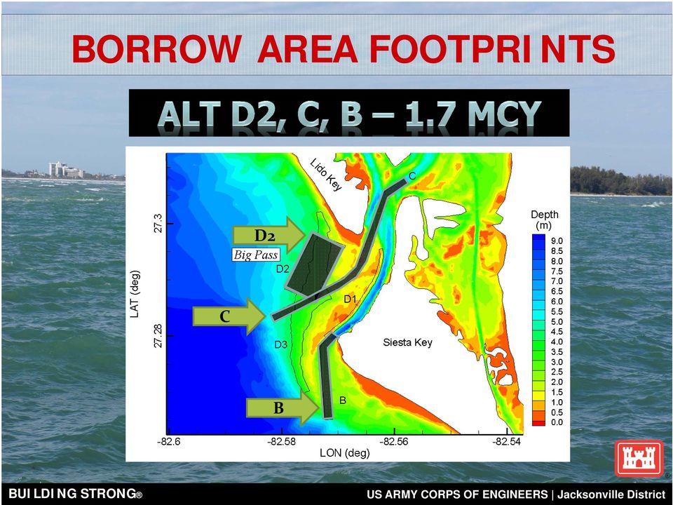
2 2 OVERVIEW PROJECT SCOPE 1971 Authorized WRDA 1999 Authority was contingent on a feasibility assessment of the project Feasibility Study with Environmental Assessment (amended April 2004) determined that project was technically sound, environmentally acceptable and economically justified

3 3 OVERVIEW PROJECT FEATURES Project Scope Project Length (ft) = 8,280 (R-35 to R43) Design berm elevation (ft) = +5 NGVD Approximately 460,000 cy of design and 615,000 cy of advance material (1,075,000 cy for Initial Const) Three groins along the southern portion Borrow Areas: Big Sarasota Pass (BSP) & New Pass 5-year nourishment interval over 50-year life 615,000 cy required for each re-nourishment D2 C B
 & New Pass 5-year nourishment interval over 50-year life 615,000 cy required for each")
4 4 PROJECT PLAN 1) Placement: Place approximately 1.1M CY of sand on Lido Key 2) Source: Obtain Sediment for Nourishment of Lido Key Egmont Key (Tampa Bay) Offshore of Longboat Key Ebb Shoal at Big Sarasota Pass (BSP) New Pass Future 3) Retain: Construct Three (3) groins at the south end of Lido Key
 New Pass Future 3) Retain: Construct Three (3) groins")
5 5 PLACEMENT LIDO KEY 2013 MHW Line 80 Design 5 MHW Line - Design Berm Advanced Berm MHW Line - Advanced Berm FDEP Monument R-39 (Lime Tree Resort/Condos)

6 6 SOURCE BSP BORROW AREAS D2 C B

7 7 RETAIN SOUTHERN GROINS

8 PROJECT PLAN BORROW AREA QUESTIONS?

9 BORROW AREAS? What are the proposed borrow area footprints? How will this affect Big Sarasota Pass morphology? How will this affect Siesta Key? What are the effects on the navigation channel?

10 BORROW AREA FOOTPRINTS D2 C B
11 In the long term: Updrift Shoal These areas will be deeper Existing Conditions

12 HOW WILL THIS AFFECT SIESTA KEY? % Increase in wave energy here and here % Decrease in wave energy here and here Results from the CMS morphologic model yields No indication of increased erosion over the Existing Condition at Siesta Key

13 EFFECT ON CURRENT NAVIGATION? Navigable water greater than 6m depth without project Navigable water greater than 6m depth with project No significant difference in navigable water depths without and with project

14 PROJECT PLAN SOUTHERN GROINS GENERAL QUESTIONS?

15 SOUTH LIDO KEY GROINS What are the plans for the groins? How long are they? How much space is between them? How big are they? Can I walk along the beach? Can I swim in the surf zone? Can I navigate past them?

16 HOW LONG? HOW MUCH SPACE IN BETWEEN? Present Day

17 HOW BIG ARE THEY?

18 CAN I WALK ALONG THE BEACH?

19 CAN I SWIM IN THE SURF ZONE? CAN I NAVIGATE PAST THEM?

20 PROJECT PLAN SOUTHERN GROINS HYPOTHETICAL QUESTIONS?

21 What if the groins do not work? What is the effect on Lido Beach? What is the effect on Siesta Key? How will the groins affect the ebb shoal in BSP? Why nourish the beach if we are installing structures?
22 WHAT IS THE EFFECT ON LIDO KEY? WHAT IS THE EFFECT ON SIESTA KEY? Sediment Bypassing to BSP Ebb Shoal Downdrift Effects Groins are constructed to anchor the nourishment template not to intercept Sediment at the expense of downdrift beaches or ebb shoal morphology!
23 How will the groins affect the ebb shoal in BSP? Sediment Bypassing to BSP Ebb Shoal Downdrift Effects Adequate sediment bypassing at the seaward end of the groin structures will deter the growth of a crescentic shoreline. Adequate bypassing to the Ebb Shoal ensures that BSP will maintain its morphology seen by lack of erosion in the shoal itself
24 Why nourish the beach if we are installing structures? Groins are constructed to anchor the nourishment template not to intercept sediment at the expense of downdrift beaches or ebb shoal morphology! Groin construction without an associated nourishment project can lead to downdrift erosion and a lack of sediment supply to downdrift systems The groins are designed to work with the nourishment design template should the beach erode shoreward of the design template, Emergency measures are implemented
25 Groins Anchor the Nourishment
26 LIDO KEY SPP Questions/Discussions Milan A. Mora, P.E. Project Manager Jacksonville District Water Resources Branch 701 San Marco Boulevard Jacksonville, FL
Strategic Beach Management Plan Southeast Atlantic Coast Region
 Page 1 of 66 Strategic Beach Management Plan Southeast Atlantic Coast Region Division of Water Resource Management Florida Department of Environmental Protection June 2015 Delray Beach Shore Protection
RESUME for Christopher G. Creed, P.E.
 Page One of Five Current Position Senior Engineer / Vice-President for Olsen Associates, Inc. a coastal engineering consulting firm in Jacksonville, Florida. Education Master of Civil Engineering, 1992.
FINAL INTEGRATED GENERAL REEVALUATION REPORT AND SUPPLEMENTAL ENVIRONMENTAL IMPACT STATEMENT
 FINAL INTEGRATED GENERAL REEVALUATION REPORT AND SUPPLEMENTAL ENVIRONMENTAL IMPACT STATEMENT BREVARD COUNTY, FLORIDA HURRICANE AND STORM DAMAGE REDUCTION PROJECT MID-REACH SEGMENT U.S. Army Corps of Engineers
Beach Management Funding Assistance Program
 FLORIDA DEPARTMENT OF ENVIRONMENTAL PROTECTION DIVISION OF WATER RESOURCE MANAGEMENT Beach Management Funding Assistance Program Local Government Funding Requests: Ranking Criteria for Beach and Inlet
SITE INVESTIGATIONS OF THE BEACH EROSION PROBLEM AT MAHO BEACH, ST. MAARTEN
 SITE INVESTIGATIONS OF THE BEACH EROSION PROBLEM AT MAHO BEACH, ST. MAARTEN Performed February 2003 Performed by: Dr. Lee E. Harris, Ph.D., P.E. Associate Professor of Ocean Engineering & Oceanography
Tropical Storm Debby. Post-Debby Beach/Dune Damage Assessment Report Sarasota Florida. By Weiqi Lin P.E., Ph.D. Coastal Resources/Community Services
 Tropical Storm Debby Post-Debby Beach/Dune Damage Assessment Report Sarasota Florida By Weiqi Lin P.E., Ph.D. Coastal Resources/Community Services June 29, 2012 BACKGROUND AND SUMMARY Tropical storm Debby
St. Lucie County - South Beaches Regional Beach Restoration
 St. Lucie County - South Beaches Regional Beach Restoration After Hurricane Sandy October 2012 Post - Construction May 2013 Tem Fontaine, P.E., M.S. Michael Walther, P.E., D.CE Ft. Pierce Inlet St. Lucie
Tropical Storm Debby
 Tropical Storm Debby Post-Debby Beach/Dune Damage Assessment Report (Draft) Sarasota Florida By Weiqi Lin P.E., Ph.D. Coastal Resources/Community Services June 28, 2012 BACKGROUND AND SUMMARY Tropical
Oakwood Beach Storm Damage Prevention Project NJDEP-Bureau of Coastal Engineering Glenn Golden, Project Manager U.S. Army Corps Civil Works Programs
 Oakwood Beach Storm Damage Prevention Project NJDEP- Glenn Golden, Project Manager U.S. Army Corps Civil Works Programs Branch Dwight Pakan, Project Manager, Philadelphia District The State of New Jersey
Hurricane and Storm Damage Reduction Study
 FLAGLER COUNTY FLORIDA Hurricane and Storm Damage Reduction Study Updated Project Management Plan - 2010 Presented by Dan Haubner Project Manager U.S. Army Corps of Engineers Jacksonville District R-1
DEPARTMENT OF THE ARMY OFFICE OF THE CHIEF OF ENGINEERS WASHINGTON, D.C. 20314-1000
 DEPARTMENT OF THE ARMY OFFICE OF THE CHIEF OF ENGINEERS WASHINGTON, D.C. 20314-1000 CEMP-SPD (l105-2-10a) APR 1 5 2012 THE SECRETARY OF THE ARMY 1. I submit for transmission to Congress my report on coastal
PALM BEACH COUNTY DEPARTMENT OF ENVIRONMENTAL RESOURCES MANAGEMENT
 PALM BEACH COUNTY DEPARTMENT OF ENVIRONMENTAL RESOURCES MANAGEMENT ENVIRONMENTAL ENHANCEMENT & RESTORATION DIVISION 2014 PALM BEACH COUNTY DEPARTMENT OF ENVIRONMENTAL RESOURCES MANAGEMENT MISSION STATEMENT
BEACH STORM DAMAGE REDUCTION EASEMENT
 STATE OF FLORIDA COUNTY OF WALTON WALTON COUNTY, FL HURRICANE & STORM DAMAGE REDUCTION PROJECT FILE/REACH#: PARCEL ID#: BEACH STORM DAMAGE REDUCTION EASEMENT KNOW ALL MEN BY THESE PRESENTS, that for and
Inlets Online: A Tutorial for Evaluating Inlet/Beach Processes Using Aerial Photography
 Inlets Online: A Tutorial for Evaluating Inlet/Beach Processes Using Aerial Photography by Mark R. Byrnes, Feng Li, and Julie D. Rosati PURPOSE: This Coastal and Hydraulics Engineering Technical Note (CHETN)
STATUS REPORT FOR THE SUBMERGED REEF BALL TM ARTIFICIAL REEF SUBMERGED BREAKWATER BEACH STABILIZATION PROJECT FOR THE GRAND CAYMAN MARRIOTT HOTEL
 STATUS REPORT FOR THE SUBMERGED REEF BALL TM ARTIFICIAL REEF SUBMERGED BREAKWATER BEACH STABILIZATION PROJECT FOR THE GRAND CAYMAN MARRIOTT HOTEL performed by Lee E. Harris, Ph.D., P.E. Consulting Coastal
Southeast Atlantic Regional Sediment Management Plan for Florida Final Report July 2009
 Southeast Atlantic Regional Sediment Management Plan for Florida Final Report July 2009 Southeast Atlantic Regional Sediment Management Plan for Florida Final Report Prepared for U.S. Army Corps of Engineers,
Using LIDAR to monitor beach changes: Goochs Beach, Kennebunk, Maine
 Geologic Site of the Month February, 2010 Using LIDAR to monitor beach changes: Goochs Beach, Kennebunk, Maine 43 o 20 51.31 N, 70 o 28 54.18 W Text by Peter Slovinsky, Department of Agriculture, Conservation
Remote sensing for the MTS
 Remote sensing for the MTS Jennifer M. Wozencraft Director, Program Manager, USACE National Coastal Mapping Program 24 June 2014, Innovative Technologies for a Resilient MTS Outline Background JALBTCX
Martin County Coastal GIS Program St Lucie Inlet Planning Tool
 Martin County Coastal GIS Program St Lucie Inlet Planning Tool Alexandra Carvalho, Ph.D., GISP Kathy Fitzpatrick, P.E. Jessica Garland Martin County, Florida Presentation Overview County Coastal Programs
Application of the Beach-fx Economic Model in St. Johns County, Florida
 Application of the Beach-fx Economic Model in St. Johns County, Florida Jason Engle, P.E. Jacksonville District USACE US Army Corps of Engineers Beach-fx Introduction St. Johns County Study Area Overview
REGIONAL SEDIMENT MANAGEMENT: A GIS APPROACH TO SPATIAL DATA ANALYSIS. Lynn Copeland Hardegree, Jennifer M. Wozencraft 1, Rose Dopsovic 2 INTRODUCTION
 REGIONAL SEDIMENT MANAGEMENT: A GIS APPROACH TO SPATIAL DATA ANALYSIS Lynn Copeland Hardegree, Jennifer M. Wozencraft 1, Rose Dopsovic 2 ABSTRACT: Regional sediment management (RSM) requires the capability
Coastal Engineering Indices to Inform Regional Management
 Coastal Engineering Indices to Inform Regional Management Lauren Dunkin FSBPA 14 February 2013 Outline Program overview Standard products Coastal Engineering Index Conclusion and future work US Army Corps
Gulf Regional Sediment Management Master Plan: Case Study Compilation
 Gulf Regional Sediment Management Master Plan: Case Study Compilation Applied Coastal Research and Engineering 766 Falmouth Road, Suite A 1 Mashpee, MA 02649 508 539 3737 mbyrnes@appliedcoastal.com 5/31/2011
City of Indian Rocks Beach, Florida NFIP Number 125117
 City of Indian Rocks Beach, Florida NFIP Number 125117 Floodplain Management Plan / Local Mitigation Strategy Annual Report - September 2015 Introduction The City of Indian Rocks Beach has been an active
Predicting Coastal Hazards: A Southern California Demonstration
 Predicting Coastal Hazards: A Southern California Demonstration Patrick Barnard United States Geological Survey Coastal and Marine Geology Team Santa Cruz, CA Southern California Multi-hazards Demonstration
ebb current, the velocity alternately increasing and decreasing without coming to
 Slack water (slack tide): The state of a tidal current when its velocity is near zero, especially the moment when a reversing current changes its direction and its velocity is zero. The term is also applied
U.S. Army Corps. of Engineers. A Learning Organization
 U.S. Army Corps A Learning Organization The Corps is committed to the protection of coral reefs and the effective mitigation of any impacts. The Corps believes that there is a need to improve the understanding
Raritan Bay and Sandy Hook Bay Highlands, New Jersey Coastal Storm Risk Management Feasibility Study. Appendix B Engineering July 2015
 Raritan Bay and Sandy Hook Bay Highlands, New Jersey Coastal Storm Risk Management Feasibility Study Appendix B Engineering July 2015 This page is intentionally left blank. Raritan Bay and Sandy Hook Bay,
ECONOMICS OF FLORIDA S BEACHES: THE IMPACT OF BEACH RESTORATION
 ECONOMICS OF FLORIDA S BEACHES: THE IMPACT OF BEACH RESTORATION JUNE 2003 ECONOMICS OF FLORIDA S BEACHES: THE IMPACT OF BEACH RESTORATION Prepared for: Florida Department of Environmental Protection Bureau
Evaluating the Condition of Seawalls/Bulkheads
 Volume 2 Evaluating the Condition of Seawalls/Bulkheads By: Coastal Systems International, Inc. Typical bulkhead under construction Seawalls and bulkheads (walls) provide shoreline stabilization for many
Geological Importance of Sand Compatibility for Sustaining Beaches (Economically Wasteful and Environmentally Damaging Beach Renourishment )
") Geological Importance of Sand Compatibility for Sustaining Beaches (Economically Wasteful and Environmentally Damaging Beach Renourishment ) Harold R. Wanless Katherine L. Maier (Donald F. McNeill) Department
Geological Importance of Sand Compatibility for Sustaining Beaches (Economically Wasteful and Environmentally Damaging Beach Renourishment ) Harold R. Wanless Katherine L. Maier (Donald F. McNeill) Department
Long Island s Dynamic South Shore
 Long Island s Dynamic South Shore A Primer on the Forces and Trends Shaping Our Coast Jay Tanski Long Island s Dynamic South Shore A Primer on the Forces and Trends Shaping Our Coast Introduction Long
APPENDIX A ENGINEERING ANALYSIS AND DESIGN
 APPENDIX A ENGINEERING ANALYSIS AND DESIGN / :. APPENDIX A ENGINEERING DESIGN AND COST ESTIMATE LIDO KEY, SARASOTA COUNTY, FLORIDA SHORE PROTECTION PROJECT FEASIBILITY REPORT Prepared For: U.S. Army Corps
Illinois Coastal Management Program 2011
 4 Coastal Erosion Assessment and Planning The Lake Michigan coast is a dynamic setting influenced by waves, ice, and changing lake levels. The potential for coastal erosion exists along nearly the entire
CONSTRUCTION DOCUMENTATION REPORTS
 ENGINEERED BERM PROJECT FOR SHORE PROTECTION ALONG CENTRAL AND SOUTHERN BREVARD COUNTY, FLORIDA Project Description and History (2005-2009) APPENDIX C CONSTRUCTION DOCUMENTATION REPORTS 2005 through 2009.
BEACH ACCESS CONFLICT CASE STUDY: SARASOTA COUNTY, FLORIDA
 BEACH ACCESS CONFLICT CASE STUDY: SARASOTA COUNTY, FLORIDA Location: Siesta Key, Sarasota County, Florida Siesta Key is an eight-mile long barrier island located along the central west coast of Florida,
Imaging Nearshore Bathymetry using a Personal Watercraft: The MGS Nearshore Survey System
 Geologic Site of the Month April, 2004 Imaging Nearshore Bathymetry using a Personal Watercraft: Text by Peter A. Slovinsky, Department of Agriculture, Conservation & Forestry 1 Modified from Wells, 1995
ENVIRONMENTAL ASSESSMENT AND FINDING OF NO SIGNIFICANT IMPACT
 ENVIRONMENTAL ASSESSMENT AND FINDING OF NO SIGNIFICANT IMPACT SHORE PROTECTION AND BEACH RENOURISHMENT PROJECT FOR OCEAN RIDGE, DELRAY BEACH, AND BOCA RATON SOUTHERN PALM BEACH COUNTY, FLORIDA Prepared
SHORELINE STABILIZATION RECOMMENDATIONS FOR PLAYA DEL SECRETO MAYA RIVIERA, Q.R., MEXICO
 SHORELINE STABILIZATION RECOMMENDATIONS FOR PLAYA DEL SECRETO MAYA RIVIERA, Q.R., MEXICO NOVEMBER 2007 PHOTOGRAPH LOOKING SOUTH ALONG PLAYA DEL SECRETO PREPARED BY: Lee E. Harris, Ph.D., P.E. Consulting
asbpa Preserving our coastal economy and ecology since 1926
 Preserving our coastal economy asbpa and ecology since 1926 HEALTHY BEACHES ARE VITAL TO OUR WAY OF LIFE People in the United States highly prize the thousands of miles of sandy beaches along our nation
BEACH NOURISHMENT COMBINED WITH SIC VERTICAL DRAIN IN MALAYSIA.
 BEACH NOURISHMENT COMBINED WITH SIC VERTICAL DRAIN IN MALAYSIA. Claus Brøgger 1 and Poul Jakobsen 2 The present paper presents measurements and results from a three year full scale Pilot Project with the
minutes I. Summary of Presentation San Francisco County Kick-off Meeting: CCAMP/OPC Study Wednesday, February 23, 2011, 2:00-4:00 PM
 San Francisco County Kick-off Meeting: CCAMP/OPC Study Wednesday, February 23, 2011, 2:00-4:00 PM LOCATION: San Francisco City Hall, Room 370 1 Dr. Carlton B. Goodlett Place San Francisco, CA 94102 ATTENDEES:
Figure 1. USGS Coastal Change Hazards home page (http://marine.usgs.gov/kb/ views/cch/). This topical node of the USGS Coastal and Marine Knowledge
. This topical node of the USGS Coastal and Marine Knowledge") THE COASTAL CHANGE HAZARDS NODE OF THE U.S. GEOLOGICAL SURVEY (USGS) COASTAL AND MARINE KNOWLEDGE BANK: ONLINE SCIENTIFIC RESOURCES FOR COASTAL ZONE MANAGEMENT AND DISASTER PREPAREDNESS M. Dennis Krohn,
THE COASTAL CHANGE HAZARDS NODE OF THE U.S. GEOLOGICAL SURVEY (USGS) COASTAL AND MARINE KNOWLEDGE BANK: ONLINE SCIENTIFIC RESOURCES FOR COASTAL ZONE MANAGEMENT AND DISASTER PREPAREDNESS M. Dennis Krohn,
Bolinas Lagoon Ecosystem Restoration Feasibility Project Marin County Open Space District
 Bolinas Lagoon Ecosystem Restoration Feasibility Project Marin County Open Space District With Funding from the California State Coastal Conservancy & the U.S. Army Corps of Engineers July 2006 Bolinas
RESTORATION AND ENHANCEMENT OF SOUTHERN CALIFORNIA LAGOONS
 RESTORATION AND ENHANCEMENT OF SOUTHERN CALIFORNIA LAGOONS by Hany Elwany, Ph.D. Scripps Institution of Oceanography Headwaters to Oceans Conference 25 October 2003 CE Ref #03-22 San Diego County Lagoons
San Francisco District. U.S. Army Corps of Engineers
 San Francisco District U.S. Army Corps of Engineers Dredged Material Management Plan for the Sacramento River Deep Water Ship Channel (SRDWSC) Deepening Project Final March 2012 Sacramento River at Rio
Los Angeles County. Open Pacific Coast Study. California Coastal Analysis and Mapping Project
 Los Angeles County Open Pacific Coast Study California Coastal Analysis and Mapping Project December 2011 Open Pacific Coast Counties Phase 1 Phase 2 California Coastal Analysis and Mapping Project Risk
The Coast of Crystal Cove Orange County, California
 The Coast of Crystal Cove Orange County, California by Hany Elwany, Ph.D. Scripps Institution of Oceanography Megan Hamilton, M.Sc. Coastal Environments Robert Robinson Dept. of Parks & Recreation Headwaters
REHABILITATION OF THE CHICAGO SHORELINE: A COASTAL ENGINEERING PERSPECTIVE
 REHABILITATION OF THE CHICAGO SHORELINE: A COASTAL ENGINEERING PERSPECTIVE Michael Krecic, P.E. Senior Engineer Taylor Engineering, Inc. 9000 Cypress Green Drive Jacksonville, FL 32256 Mark Wagstaff, P.E.
COASTAL SETBACK AND CONTROL LINES* * Cross References: Coastal construction code, 22-351 et seq.
 CHAPTER 62, ARTICLE XII. COASTAL SETBACK AND CONTROL LINES* * Cross References: Coastal construction code, 22-351 et seq. Sec. 62-4201. Definitions and rules of construction. For the purpose of this article,
PERPETUAL STORM DAMAGE REDUCTION EASEMENT Pre-Existing Structure. THIS PERPETUAL STORM DAMAGE REDUCTION EASEMENT is made BY AND BETWEEN.
 PERPETUAL STORM DAMAGE REDUCTION EASEMENT Pre-Existing Structure THIS PERPETUAL STORM DAMAGE REDUCTION EASEMENT is made BY AND BETWEEN residing at herein after referred to as Grantor, AND Suffolk County
Mouth of the Columbia River Jetties Major Rehabilitation Study
 Mouth of the Columbia River Jetties Major Rehabilitation Study PNWA Port of Vancouver January 29, 2010 US Army Corps of Engineers Project Overview Background Corps Guidance for Major Rehab Project Alternatives
Implementing the Water Resources Development Act of 2007
 Implementing the Water Resources Development Act of 2007 Rich Worthington U.S. Army Corps of Engineers, Headquarters December 5, 2007 WRDA 2007 (PL 110-114 ) PROVISIONS IMPORTANT TO AAPA STATUS: Passed
30 DAY PUBLIC NOTICE MAINTENANCE DREDGING OF THE FEDERAL NAVIGATION PROJECT IN COHASSET HARBOR COHASSET AND SCITUATE, MASSACHUSETTS
 .-ro:'j - I US Army Corps of Engineers r& New England District 696 Virginia Road Concord, MA 01742-2751 Public Notice In Reply Refer to: Mr. Craig Martin nae-pn-nav@usace.army.mil Programs/Project Management
POINTS TO CONSIDER WHEN BUYING SHORELINE PROPERTY
 POINTS TO CONSIDER WHEN BUYING SHORELINE PROPERTY You re considering buying a piece of property. You ve found two properties which meet your needs and interest you. Both properties are about two acres
NANTASKET BEACH DCR Reservation Hull, Massachusetts
 Coastal Storm Damage Reduction Report DRAFT Feasibility Report and Environmental Assessment NANTASKET BEACH DCR Reservation Hull, Massachusetts US ARMY CORPS OF ENGINEERS New England District May 2014
OCEAN BEACH-GREAT HIGHWAY STORM DAMAGE PROTECTION PROJECT
 OCEAN BEACH-GREAT HIGHWAY STORM DAMAGE PROTECTION PROJECT Final Report Prepared for: San Francisco Department of Public Works U.S. Army Corps of Engineers May 31, 2005 OCEAN BEACH-GREAT HIGHWAY STORM DAMAGE
Planning for Sea Level Rise before and after a Coastal Disaster
 Chapter 8 Planning for Sea Level Rise before and after a Coastal Disaster James G. Titus INTRODUCTION Ocean beach resorts in the United States have always faced erosion and storm damage. At first, these
Mission Creek Flood Control & Restoration Project. City of Fremont, Alameda County
 Mission Creek Flood Control & Restoration Project City of Fremont, Alameda County Agenda Background Why are proposed improvements necessary? Proposed project components Challenges Construction schedule/phasing
Form 8-K. Shepherd s Finance, LLC (Exact name of registrant as specified in its charter)
") UNITED STATES SECURITIES AND EXCHANGE COMMISSION Washington, D.C. 20549 Form 8-K Current Report Pursuant to Section 13 or 15(d) of the Securities Exchange Act of 1934 Date of Report (Date of earliest event
UNITED STATES SECURITIES AND EXCHANGE COMMISSION Washington, D.C. 20549 Form 8-K Current Report Pursuant to Section 13 or 15(d) of the Securities Exchange Act of 1934 Date of Report (Date of earliest event
Middlesex County Wetlands Board Minutes. February 8, 2000
 Middlesex County Wetlands Board Minutes February 8, 2000 Call to Order The February 8, 2000 meeting of the Middlesex County Wetlands Board was called to order by Chair Sherman T. Holmes at 9:00 A.M. in
An Initial Assessment of the Impacts of Sea Level Rise to the California Coast
 An Initial Assessment of the Impacts of Sea Level Rise to the California Coast Photo by D. Revell 2/23/08 California Coastal Records Project Dr. David Revell and Matt Heberger, P.E. Dr. Peter Gleick, Bob
Hurricane Sandy: Beach-dune performance at New Jersey Beach Profile Network sites
 Hurricane Sandy: Beach-dune performance at New Jersey Beach Profile Network sites The Coastal Research Center (CRC) at the Richard Stockton College of New Jersey has been collecting beach and nearshore
Storm tide is the water level rise during a storm due to the combination of storm surge and the astronomical tide.
 INTRODUCTION TO STORM SURGE Introduction to Storm Surge BOLIVAR PENINSULA IN TEXAS AFTER HURRICANE IKE (2008) What is Storm Surge? Inland Extent Storm surge can penetrate well inland from the coastline.
Appendix E. Definition of Options
 Appendix E Definition of Options Table of Contents 1 Introduction... 1 2 Buffalo Beach Southern Section... 1 2.1 Status Quo...1 2.2 Purchase of Beachfront Properties and Rezone as Open Space Policy Area...2
The Board of County Commissioners, Walton County, Florida, held a. Public Hearing on Tuesday, December 15, 1998, at 5:00 p.m.
 PUBLIC HEARING DECEMBER 15, 1998 The Board of County Commissioners, Walton County, Florida, held a Public Hearing on Tuesday,, at 5:00 p.m., in the Tourist Development Council's Meeting Room. The following
Pamela Joan Christian. Bachelor of Science Biology Florida State University 1991. Master of Education In Secondary Science Winthrop University 1997
 Ponce de Leon Inlet, FL: An Integrated Hydrodynamic and Morphologic Assessment of Design Alternatives using the U.S. Army Corps of Engineers' Coastal Modeling System by Pamela Joan Christian Bachelor of
Section 401 Water Quality Certification
 Section 401 Water Quality Certification Department of Health Environmental Management Division Clean Water Branch Voice: (808) 586-4309 Fax: (808) 586-4352 http://www.hawaii.gov/health/environmental/water/cleanwater/index.html
RUSSIAN RIVER ESTUARY OUTLET CHANNEL ADAPTIVE MANAGEMENT PLAN 2012
 RUSSIAN RIVER ESTUARY OUTLET CHANNEL ADAPTIVE MANAGEMENT PLAN 2012 Prepared for Sonoma County Water Agency Prepared by ESA PWA with Bodega Marine Laboratory, University of California at Davis July 20,
ANATOMY OF A MUDSLIDE AND DAMAGE CAUSED BY HURRICANE IVAN
 ANATOMY OF A MUDSLIDE AND DAMAGE CAUSED BY HURRICANE IVAN by Jim Hooper, Fugro-McClelland Marine Geosciences Presented at the Houston Marine Insurance Seminar Westin Galeria Hotel, Houston Texas September
Presented by: William R. Miles, PE Director of Civil Works Bergmann Associates, DPC Jacksonville, FL & Rochester, NY. www.bergmannpc.
 our people and our passion in every project Presented by: William R. Miles, PE Director of Civil Works Bergmann Associates, DPC Jacksonville, FL & Rochester, NY Presentation Agenda Facility History Inspections
Storm tide is the water level rise during a storm due to the combination of storm surge and the astronomical tide.
 INTRODUCTION TO STORM SURGE Introduction to Storm Surge National Hurricane Center Storm Surge Unit BOLIVAR PENINSULA IN TEXAS AFTER HURRICANE IKE (2008) What is Storm Surge? Inland Extent Storm surge can
COASTAL DAMAGE INSPECTION SOUTHWEST VITI LEVU, FIJI AFTER CYCLONE SINA
 COASTAL DAMAGE INSPECTION SOUTHWEST VITI LEVU, FIJI AFTER CYCLONE SINA Brendan J. Holden SOPAC Technical Secretariat July 1992 SOPAC Technical Report 148 Prepared for: South Pacific Applied Geoscience
NEW JERSEY SEA GRANT COLLEGE PROGRAM MANUAL FOR COASTAL HAZARD MITIGATION. Compiled by Thomas O. Herrington
 NEW JERSEY SEA GRANT COLLEGE PROGRAM MANUAL FOR COASTAL HAZARD MITIGATION Compiled by Thomas O. Herrington 2 PREFACE New Jersey is often used as an example of a natural system gone awry. The unflattering
Potential Dredged Material Storage Facilities and Their Impact on Public Processing Facility Economic Modeling Summary Report
 Port of New York and New Jersey Feasibility Analysis for a Dredged Material Public Processing Facility Potential Dredged Material Storage Facilities and Their Impact on Public Processing Facility Economic
California Alluvial Fan Task Force
 California Alluvial Fan Task Force County of San Diego Alluvial Fan Flooding and Risk Reduction Sara Agahi, PE, CFM January 4, 2008 Outline of Presentation Show location of San Diego County Alluvial Fan
R. CHRISTOPHER JONES, PH.D. President & Chief Economist, Florida Economic Advisors, LLC
 R. CHRISTOPHER JONES, PH.D. President & Chief Economist, Florida Economic Advisors, LLC Professional Profile Dr. Chris Jones serves as the President and Chief Economist of Florida Economic Advisors, LLC.
2011 Operations, Maintenance, Monitoring and Rehabilitation Plan
 State of Louisiana Coastal Protection and Restoration Authority of Louisiana 2011 Operations, Maintenance, Monitoring and Rehabilitation Plan for East Marsh Island Marsh Creation State Project Number TV-21
SHOALS Toolbox: Software to Support Visualization and Analysis of Large, High-Density Data Sets
 SHOALS Toolbox: Software to Support Visualization and Analysis of Large, High-Density Data Sets by Jennifer M. Wozencraft, W. Jeff Lillycrop, and Nicholas C. Kraus PURPOSE: The Coastal and Hydraulics Engineering
STAFF REPORT: CONSENT CALENDAR. Vasanth Venugopal. 367 Via Lido Soud, City of Newport Beach (County of Orange)
") STATE OF CALIFORNIA - NATURAL RESOURCES AGENCY CALIFORNIA COASTAL COMMISSION South Coast Area Office 200 Oceangate, Suite 1000 Long Beach, CA 90802-4302 (562) 590-5071 EDMUND G. BROWN, Jr., Governor F
STATE OF CALIFORNIA - NATURAL RESOURCES AGENCY CALIFORNIA COASTAL COMMISSION South Coast Area Office 200 Oceangate, Suite 1000 Long Beach, CA 90802-4302 (562) 590-5071 EDMUND G. BROWN, Jr., Governor F
FINAL REPORT FOR 2012 ON THE CONDITION OF THE MUNICIPAL BEACHES IN THE CITY OF BRIGANTINE BEACH, ATLANTIC COUNTY, NEW JERSEY
 FINAL REPORT FOR 2012 ON THE CONDITION OF THE MUNICIPAL BEACHES IN THE CITY OF BRIGANTINE BEACH, ATLANTIC COUNTY, NEW JERSEY Photograph was taken November 3, 2012 from 10 th Street North looking south
Final Project Report
 CURTIN UNIVERSITY OF TECHNOLOGY Department of Applied Geology Western Australia School of Mines Applied Sedimentology, Coastal and Marine Geoscience Group GERALDTON EMBAYMENTS COASTAL SEDIMENT BUDGET STUDY
DEPARTMENT OF THE ARMY US ARMY CORPS OF ENGINEERS SOUTH ATLANTIC DIVISION 60 FORSYTH ST, SW, ROOM 10M15 ATLANTA, GEORGIA 30303-3490
 DEPARTMENT OF THE ARMY US ARMY CORPS OF ENGINEERS SOUTH ATLANTIC DIVISION 60 FORSYTH ST, SW, ROOM 10M15 ATLANTA, GEORGIA 30303-3490 CESAD-CG REPLY TO ATIENTION OF: 12 Jan 2015 MEMORANDUM FOR Commander,
VALE DO LOBO (PORTUGAL)
") VALE DO LOBO (PORTUGAL) Contact: Fernando VELOSO GOMES Francisco TAVEIRA PINTO Instituto de Hidráulica e Recursos Hídricos - IHRH Rua Dr. Roberto Frias, s/n 4200-465 Porto (Portugal) e-mails: vgomes@fe.up.pt
VALE DO LOBO (PORTUGAL) Contact: Fernando VELOSO GOMES Francisco TAVEIRA PINTO Instituto de Hidráulica e Recursos Hídricos - IHRH Rua Dr. Roberto Frias, s/n 4200-465 Porto (Portugal) e-mails: vgomes@fe.up.pt
Develop hazard mitigation policies and programs designed to reduce the impact of natural and human-caused hazards on people and property.
 6.0 Mitigation Strategy Introduction A mitigation strategy provides participating counties and municipalities in the H-GAC planning area with the basis for action. Based on the findings of the Risk Assessment
TAKINGS LAW: BEFORE & AFTER Stop the Beach Renourishment, Inc. v. FDEP Presented by: Stephen A. Walker, Esq. Daniel D. Richardson, Esq. Andrew J.
 TAKINGS LAW: BEFORE & AFTER Stop the Beach Renourishment, Inc. v. FDEP Presented by: Stephen A. Walker, Esq. Daniel D. Richardson, Esq. Andrew J. Baumann, Esq.. Inverse Condemnation Inverse condemnation
MONITORING STANDARDS FOR BEACH EROSION CONTROL PROJECTS
 MONITORING STANDARDS FOR BEACH EROSION CONTROL PROJECTS May 2014 Edited: October 2014 Division of Water Resource Management Department of Environmental Protection State of Florida MONITORING STANDARDS
FINAL Environmental Impact Statement (EIS) for the
 for the") FINAL Environmental Impact Statement (EIS) for the Mississippi River-Gulf Outlet (MRGO), Louisiana, and Lake Borgne Wetland Creation and Shoreline Protection Project U.S. Army Corps of Engineers New Orleans
FINAL Environmental Impact Statement (EIS) for the Mississippi River-Gulf Outlet (MRGO), Louisiana, and Lake Borgne Wetland Creation and Shoreline Protection Project U.S. Army Corps of Engineers New Orleans
THE HOMEOWNER S GUIDE TO THE COASTAL CONSTRUCTION CONTROL LINE PROGRAM (SECTION 161.053, FLORIDA STATUTES)
") THE HOMEOWNER S GUIDE TO THE COASTAL CONSTRUCTION CONTROL LINE PROGRAM (SECTION 161.053, FLORIDA STATUTES) The Florida Department of Environmental Protection Division OF Water Resource Management February
THE HOMEOWNER S GUIDE TO THE COASTAL CONSTRUCTION CONTROL LINE PROGRAM (SECTION 161.053, FLORIDA STATUTES) The Florida Department of Environmental Protection Division OF Water Resource Management February
Updated Federal Emergency Management Agency Flood Insurance Rate Maps and Zoning Ordinance Update. July 16, 2015 Policy Committee
 Updated Federal Emergency Management Agency Flood Insurance Rate Maps and Zoning Ordinance Update July 16, 2015 Policy Committee FEMA Map Update Costal Analysis and mapping study by FEMA in 2009 Changes
ON THE COVER. Breach Event at Water Island, Fire Island National Seashore, 1993 Photo by James R. Allen
 National Park Service U.S. Department of the Interior Northeast Region Boston, Massachusetts Recommendations for a Barrier Island Breach Management Plan for Fire Island National Seashore, including the
Strengthening the Fire Island Flood-barrier Beach
 Strengthening the Fire Island Flood-barrier Beach Fire Island Association positions regarding the Corps upcoming reformulation report for long-term shore protection of Fire Island and across the Great
Looking for property near the ocean?
 Looking for property near the ocean? Questions and Answers on Purchasing Coastal Real Estate in Massachusetts This brochure focuses on questions you should ask as a potential purchaser of coastal real
Hurricanes and Storm Surge www.hcfcd.org/tropicalweather
 Hurricanes and Storm Surge www.hcfcd.org High-level winds fl ow outward Strong surface winds spiral inward EYE Calm, sometimes cloudfree, sinking air Air sinks in calm area at the storm s eye THUNDERSTORMS
SEAPRO has both foam filled flotation boom and inflatable boom systems.
 BOOMING OPERATIONS SEAPRO Response Operations Manual General Information Booming operations are necessary for the containment and concentration of spilled oil on water. By containing product, potential
Shoreline Evolution Chesapeake Bay Shoreline City of Norfolk, Virginia
 Shoreline Evolution Chesapeake Bay Shoreline City of Norfolk, Virginia Virginia Institute of Marine Science College of William & Mary Gloucester Point, Virginia 2005 Shoreline Evolution Chesapeake Bay
http://www.nj.gov/dep/shoreprotection/storm.htmhris TUCKER
 COASTAL STORM SURVEY NEW JERSEY DEPARTMENT OF ENVIRONMENTAL PROTECTION BUREAU OF COASTAL ENGINEERING - TOMS RIVER NJ 12:00 P.M. TUESDAY, MARCH 1, 2005 NEW JERSEY COASTLINE INCLUDING RARITAN AND DELAWARE
AVALON PARK WEST (FORMERLY NEW RIVER) PD/MPUD- NARRATIVE FOR DRI RESCISSION, PD SUBAREA AMENDMENT AND MPUD SUBSTANTIAL MODIFICATION.
 PD/MPUD- NARRATIVE FOR DRI RESCISSION, PD SUBAREA AMENDMENT AND MPUD SUBSTANTIAL MODIFICATION.") AVALON PARK WEST (FORMERLY NEW RIVER) PD/MPUD- NARRATIVE FOR DRI RESCISSION, PD SUBAREA AMENDMENT AND MPUD SUBSTANTIAL MODIFICATION DRI Rescission On January 7, 1992, the Pasco County Board of County Commissioners
AVALON PARK WEST (FORMERLY NEW RIVER) PD/MPUD- NARRATIVE FOR DRI RESCISSION, PD SUBAREA AMENDMENT AND MPUD SUBSTANTIAL MODIFICATION DRI Rescission On January 7, 1992, the Pasco County Board of County Commissioners
RISKS THE HERBERT HOOVER DIKE LLOYD S EMERGING RISKS TEAM REPORT
 RISKS LLOYD S EMERGING RISKS TEAM REPORT THE HERBERT HOOVER DIKE A DISCUSSION OF THE VULNERABILITY OF LAKE OKEECHOBEE TO LEVEE FAILURE; CAUSE, EFFECT AND THE FUTURE 2 Disclaimer This document is intended
Sea Level Change. Miami-Dade Sea Level Rise Task Force
 Sea Level Change and LongProgram Range Everglades Restoration Climate Water Resources Planning for Florida Change Application Concerns of USACE andguidance Draft Sea Level on Sea Rise Level Planning Change