Architectural Services
|
|
|
- Adelia Hampton
- 3 years ago
- Views:
From this document you will learn the answers to the following questions:
What is the name of the Siuslaw River?
What kind of opportunities will the Siuslaw Estuary Trail provide?
What type of viewing will be available on the Siuslaw Estuary Trail?
Transcription
1 Architectural Services for New PW Facility S EA (Sco Edwards Architects Contract $130,000 Expenses $10,000 Contract Total $140,000 Original conceptual layout by HSR/Waterleaf 1

2 Working with reduced funding one concept to create office and maintenance facilities Original conceptual layout by HSR/Waterleaf Another concept is to construct a large enough maintenance facility to allow temporary office space within the building shell. When there are additional funds (after 5 yrs) the office space can be converted to maintenance area. 2
 the office space can be converted to")
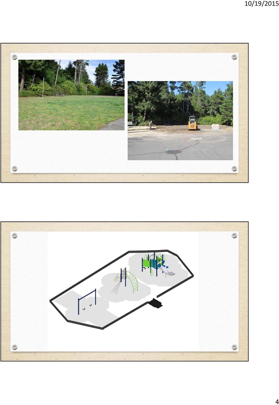
3 Oregon Parks and Recreation Grant Pepperoaks playground equipment rehabilitation project Local Government Grant Program Provides City with $24,712 in funding City match is $16,750 3

4 4
5 STIP Enhance Grant Pedestrian and Bicycle Improvements on Hwy 101 between Siuslaw River Bridge and Hwy 126 5

6 STIP Enhance STIP Funding Request $750,000 City/FURA Match $250,000 Project Total $1,000,000 Current conditions looking south from Nopal Street Timeline Presentation to LaneACT October 14 th Final Proposals due November 20 th LaneACT ranks proposals to 150% list Super ACT creates 150% list January Feb. June 2016 project scoping occurs July 2016 Super ACT develops 100% list August 2016 Funding requests to OTC October 2016 OTC selects projects 6

7 ConnectOregon VI Siuslaw Estuary Trail, Phase II Project Description A collaborative project by the City of Florence and Port of Siuslaw to construct a recreational trail along the Siuslaw River Estuary in Old Town, Florence, Oregon. The Siuslaw Estuary Trail is a phased project with multiple sections. Phase 1 is already funded through the STIP. Our ConnectOregon VI grant request includes sections 1 and 2. 7

8 Vicinity Map Project Description Section 1: South Trailhead to Boardwalk Existing Old Town Scenic Route (2,544 feet) Upland Trail Link with Port of Siuslaw Board Walk (1,570 feet) Signed Natural Footpath along the Estuary Section 2: Port Campground Link Cantilevered Steel Grate Walkway 8

9 Site Plan Project Description Siuslaw Estuary Trail is a non-motorized multi-use trail that will provide ADA accessible opportunities for: Hiking Biking Jogging Kayaking Nature walks Wildlife viewing 9

10 ConnectOregon VI Grant Request Grant Request $500,000 Required Match of 30% 30% match equals $200,000 Funds could be a combination of City and FURA Engineering Trail construction Kiosk and Overlook Purchase of land for footpath Metal Grate walkway construction Trail Benefits Provides an attractive destination for physical exercise for residents and visitors Promotes good stewardship of the estuary and its ecosystem Provides a regional draw to Florence and surrounding area Will help stimulate economy by bringing visitors to Old Town 10

11 Environmental Benefits Provides environmentally responsible pedestrian and bicycle system Will be constructed of sustainable, non-polluting materials, ensuring conservation of natural resources Section 2 will feature 350-foot cantilevered steel grate walkway, which will allow light to pass through to the wetland plants below. Will lessen local reliance on automobile travel Section 1: South trailhead to Boardwalk Link to existing Old Town Scenic Route and Scenic Byways Interpretive Site via signage and sidewalk monuments Trail construction will extend the Boardwalk along the estuary toward the Port Campground Signed natural footpath in Estuary 11

12 Section 1: South trailhead to Boardwalk East end of existing Old Town Scenic Trail Section 1: South trailhead to Boardwalk End of existing Port boardwalk looking east 12

13 Section 1: South trailhead to Boardwalk Proposed Estuary Trail looking west Section 1: South trailhead to Boardwalk View looking SW along natural footpath area 13

14 Section 1: South trailhead to Boardwalk View from proposed natural footpath into estuary Section 1: South trailhead to Boardwalk View of estuary from north side of dredged materials spoils site 14

15 Section 2: Port Campground Link Construct 350 foot cantilevered galvanized steel grate walkway adjacent to the Port Campground, which will provide filtered views of the tidal wetlands and estuary for nature walks and bird watching. Section 2: Port Campground Link Views from the estuary towards the campground 15

16 Section 2: Port Campground Link Eastern edge of Port campground Consistent with adopted plans The Siuslaw Estuary Trail is part of City s: Transportation Plan Comprehensive Plan Parks Plan Downtown Implementation Plan Siuslaw Estuary Trail Vision Report work product from EPA West Coast Estuaries Initiative Grant (Siuslaw Estuary Partnership) 16

17 Questions and Comments 17

APPENDIX B: TRAIL DEVELOPMENT AND MANAGEMENT STANDARDS
 APPENDIX B: TRAIL DEVELOPMENT AND MANAGEMENT STANDARDS This section provides guidance on a variety of trail issues for planners and developers of the Ice Age NST across the state. It also provides introductory
Motorcycle & Pedestrian Master Plans in Indianapolis, Indiana
 PROJECT PURPOSE The Warsaw + Winona Lake Bicycle and Pedestrian Master Plan establishes a comprehensive framework for a connected bicycle and pedestrian system that will be used for both recreation and
PUBLIC INFORMATIONAL MEETING THURSDAY APRIL 30, 2015
 PUBLIC INFORMATIONAL MEETING THURSDAY APRIL 30, 2015 AT ACTON TOWN HALL FAULKNER ROOM 472 MAIN STREET ACTON, MASSACHUSETTS 7:00 PM FOR THE PROPOSED ASSABET RIVER RAIL TRAIL (ARRT) IN THE TOWNS OF ACTON
Bowmanville Marsh Habitat Restoration and Public Access Project
 Bowmanville Marsh Habitat Restoration and Public Access Project Terms of Reference for Detailed and Conceptual Design Works December 2015 1.0 Background and Purpose The Bowmanville Marsh Habitat Restoration
CITY OF PORT ISABEL An Equal Opportunity Provider and Employer 305 East Maxan Port Isabel, Texas 78578 (956) 943-2682 (956) 943-2029 Facsimile
 943-2682 (956) 943-2029 Facsimile") CITY OF PORT ISABEL An Equal Opportunity Provider and Employer 305 East Maxan Port Isabel, Texas 78578 (956) 943-2682 (956) 943-2029 Facsimile Memorandum: Date: February 11, 2014 To: From: Subject: Roger
CITY OF PORT ISABEL An Equal Opportunity Provider and Employer 305 East Maxan Port Isabel, Texas 78578 (956) 943-2682 (956) 943-2029 Facsimile Memorandum: Date: February 11, 2014 To: From: Subject: Roger
APPENDIX G. California Coastal Commission & Conservancy Accessibility Standards
 APPENDIX G California Coastal Commission & Conservancy Accessibility Standards STANDARDS AND RECOMMENDATIONS FOR ACCESSWAY LOCATION AND DEVELOPMENT These standards provide guidelines for the location,
Technical Appendix. Technical Appendix UNLV LANDSCAPE ARCHITECTURE & PLANNING RESEARCH
 TABLE of CONTENTS SECTION ONE: Potential Community Funding Sources...A.1 SECTION TWO: Mapping Ecosystems Along Nevada Highways...A.4 UNLV LANDSCAPE ARCHITECTURE & PLANNING RESEARCH SECTION ONE: Potential
Dorset Green SANGs Report
 Dorset Green SANGs Report April 2012 FARRELLS Contents 1.0 Introduction 1.1 Accessible Green Spaces 2.0 SANGs Objectives 2.1 Proposals 2.2 Ecology Park 2.3 Village Green 2.4 Country Heritage Park 2.5 Dorset
THE RUSKIN COMMUNITY PLAN
 THE RUSKIN COMMUNITY PLAN Introduction Ruskin is a historic community situated on the shores of Tampa Bay, the Little Manatee River and the Ruskin Inlet, approximately 16 miles southeast of Tampa. The
Missouri Department of Transportation
 Missouri Department of Transportation Transportation Alternatives 2014 Table of Contents A Guide to Transportation Alternatives Page I. Transportation Alternatives Activities 2 II. Project Eligibility
Transportation Alternatives Program (TAP)
") Transportation Alternatives Program (TAP) 2013 Workshop for project funding in 2017 and 2018 Introductions Transportation Alternatives Program (TAP) Federal Highway Administration (FHWA) program Administered
Transportation Alternatives Program (TAP) 2013 Workshop for project funding in 2017 and 2018 Introductions Transportation Alternatives Program (TAP) Federal Highway Administration (FHWA) program Administered
Summary Community Workshop #2 Fruitvale San Antonio Senior Center. Wednesday, April 22, 2009 7:00-9:00 p.m.
 Summary Community Workshop #2 Wednesday, April 22, 2009 7:00-9:00 p.m. Workshop Format and Process The City of Oakland is preparing a Specific Plan that will help define and determine a common vision for
CITY OF ROANOKE AND TOWN OF VINTON, VIRGINIA. RSTP Funds Joint Application FOR
 CITY OF ROANOKE AND TOWN OF VINTON, VIRGINIA RSTP Funds Joint Application FOR Tinker Creek Pedestrian Bridge: Tinker Creek and Glade Creek Greenways Connection Date: September 15, 2014 RSTP Project Profile
3.1 Historical Considerations
 3. Recommended Scope of Bridge improvements 3.1 Historical Considerations In the fall of 2000, an outside consultant, Fraser Design, suggested that the existing 4 th St. Bridge is potentially eligible
Stormwater Wetland Design and Construction Mitigation Duke Bitsko. Construction Activities, Schedule and Sequence Tom Ritchie
 September 7, 2011 Welcome Catherine Daly Woodbury DCR Coordination Dan Driscoll Project Background Catherine Daly Woodbury Stormwater Wetland Design and Construction Mitigation Duke Bitsko Construction
The project site lies within an AE Zone and portions lie within the regulated floodway. Development of this site is subject to TCLUO, Section 3.060.
 Introduction This application is for the Southern Flow Corridor-Landowner Preferred Alternative, a flood mitigation and tidal wetland restoration project. The Port of Tillamook Bay is the applicant in
REHABILITATION PACKAGE 1-a
 1-a WINONA BRIDGE (BRIDGE 5900) REHABILITATION PACKAGE 1-a Rehab option 1-a is a rehabilitation package whereby all spans of the existing structure would be rehabilitated to the degree feasible and strengthened
Town of Snowmass Village. PO Box 5010. Or Delivered To: 1 P a g e
 The Town of Snowmass Village invites qualified consultants to submit a proposal to develop a Request Community for Connectivity Proposals Plan for the Town. Proposals must be submitted by 4:00 pm Friday
Appendix B - National Park Service Management Policies
 Appendix B - National Park Service Management Policies The following policy statements pertaining to transportation and visitor facilities are from the NPS Management Policies 2001. Consistent with applicable
NEZ PERCE-CLEARWATER FORESTS
 United States Department of Agriculture Forest Service NEZ PERCE-CLEARWATER FORESTS Fish Creek Meadows A Year-Round Playground For Idaho and the Northwest Fish Creek Meadows Year-round Recreation For Everyone
Ch a p t e r 5. Bridges Decks and Boardwalks
 05 Ch a p t e r 5 Park Structures Bridges Decks and Boardwalks Intentionally Blank Br i d g e s Chapter 5: Park Structures Pu r p o s e Bridges shall facilitate safe access across bodies of water, unstable
Approved Natural Disaster Recovery Round Green Army projects
 Approved Natural Disaster Recovery Round Green Army projects Project Title Project Description State Territory Belmont Wetlands East Coast This project will reduce erosion and revegetate and control weeds
Open House Public Meeting for the Thurmond Bridge Rehabilitation Project State Project: State Project S310-25/2-0.10 Federal Project: BR-0252(001)D
D") Open House Public Meeting for the State Project: State Project S310-25/2-0.10 Federal Project: BR-0252(001)D May 7, 2015 Old Glen Jean Bank Glean Jean, WV 4:00-7:00 PM www.transportation.wv.gov PROJECT
Open House Public Meeting for the State Project: State Project S310-25/2-0.10 Federal Project: BR-0252(001)D May 7, 2015 Old Glen Jean Bank Glean Jean, WV 4:00-7:00 PM www.transportation.wv.gov PROJECT
Welcome to the future of Terwillegar Park a Unique Natural Park
 Welcome to the future of Terwillegar Park a Unique Natural Park 1 Introduction The Terwillegar Park Concept Plan study will develop an overall concept plan, management objectives and development guidelines
Indian River Lagoon National Scenic Byway Coalition Nonprofit Annual Report FY 2013
 Indian River Lagoon National Scenic Byway Coalition Nonprofit Annual Report FY 2013 February 2014 February 2014 Letter from the Chair In the spring of 1999, a group of community advocates including county,
Bicycle and Pedestrian Subcommittee (BPS) Recommendation FY 2015 Transportation Alternatives Program (TAP) Allocation
 Recommendation FY 2015 Transportation Alternatives Program (TAP) Allocation") Bicycle and Pedestrian Subcommittee (BPS) Recommendation FY 2015 Transportation Alternatives Program (TAP) Allocation The Montgomery Metropolitan Planning Organization (MPO) receives a direct annual allocation
Bicycle and Pedestrian Subcommittee (BPS) Recommendation FY 2015 Transportation Alternatives Program (TAP) Allocation The Montgomery Metropolitan Planning Organization (MPO) receives a direct annual allocation
FLORENCE DOWNTOWN PRESERVATION AND RENEWAL PLAN. 10 TH Draft, August 21, 2006 Agency Approved Referred To Florence Council
 FLORENCE DOWNTOWN PRESERVATION AND RENEWAL PLAN 10 TH Draft, August 21, 2006 Agency Approved Referred To Florence Council City of Florence August 21, 2006 FLORENCE DOWNTOWN URBAN RENEWAL PLAN ACKNOWLEDGEMENTS
Cannon Beach Comprehensive Plan CODIFIED With Amendments through June 2013 (Through Ordinance 13-01)
") Cannon Beach Comprehensive Plan CODIFIED With Amendments through June 2013 (Through Ordinance 13-01) City of Cannon Beach, PO Box 368, OR 97110 Telephone: 503-436-1581 Fax: 503-436-2050 Website: http://www.ci.cannon-beach.or.us
Cannon Beach Comprehensive Plan CODIFIED With Amendments through June 2013 (Through Ordinance 13-01) City of Cannon Beach, PO Box 368, OR 97110 Telephone: 503-436-1581 Fax: 503-436-2050 Website: http://www.ci.cannon-beach.or.us
Goals, Strategies, and Tasks
 Goals, Strategies, and Tasks Goals are the broadest expressions of a community's desires. Goals give direction to the plan as a whole. Goals are concerned with the long term, and often describe ideal situations
IT S HARD TO BELIEVE THE INNER HARBOR IS 40 YEARS OLD
 inner harbor 2.0 IT S HARD TO BELIEVE THE INNER HARBOR IS 40 YEARS OLD In 1973, the Inner Harbor public promenade was completed, setting the framework for all development to follow. Heralded as a model
Arkansas River Corridor Vision & Master Plan
 A r k a n s a s R I v e r C o r r I d o r P l a n Arkansas River Corridor Vision & Master Plan July 2005 Indian Nations Council of Governments A r k a n s a s R I v e r C o r r I d o r P l a n Partnership
825 Babock Court Raleigh, North Carolina 27609. March 7, 2014
 825 Babock Court Raleigh, North Carolina 27609 March 7, 2014 LaGasse Medal Nominations Landscape Architect c/o Carolyn Mitchell 636 Eye Street, NW Washington, DC 20001-3736 To the ASLA Executive Committee
Summary. Run By the Sea 226 Jeter Street Santa Cruz, CA 95060 Phone: 831 272 4627 Email: whatisron@gmail.com Web: www.runbythesea.
 Run By the Sea 226 Jeter Street Santa Cruz, CA 95060 Phone: 831 272 4627 Email: whatisron@gmail.com Web: www.runbythesea.org Ohlone Rail Trail Proposal We propose opening a section of north coast farm
Downtown Tampa Transportation Vision
 Downtown Tampa Transportation Vision Executive Summary August 1, 2006 Hillsborough County Metropolitan Planning Organization County Center, 18 th Floor Tampa, Florida 33602 813-272-5940 www.hillsboroughmpo.org
MICHIGAN S LANDSCAPE ARCHITECTS
 MICHIGAN S LANDSCAPE ARCHITECTS protecting the health, safety, and welfare of our citizens site design land use planning master planning streetscape design brownfield redevelopment guidelines and regulations
CHIPPEWA FALLS RIVERFRONT PARK
 CHIPPEWA FALLS RIVERFRONT PARK PHASE 1: MASTER PLAN REVIEW AND EVALUATION E-NEWSLETTER #1 Friday, April 4, 2014 MISSION STATEMENT: VISION 2020 CHIPPEWA FALLS Enhance the natural beauty, recreational opportunity
Goals & Objectives. Chapter 9. Transportation
 Goals & Objectives Chapter 9 Transportation Transportation MISSION STATEMENT: TO PROVIDE A TRANSPORTATION NETWORK CAPABLE OF MOVING PEOPLE AND GOODS EFFICIENTLY AND SAFELY. T he transportation system
 Walkable Communities Florida Department of Transportation State Safety Office Pedestrian and Bicycle Program April 1995 www.dot.state.fl.us/safety Twelve Steps for an Effective Program Page 1 Twelve Steps
TRANSPORTATION ALTERNATIVES PROGRAM (TAP) PROJECT SUBMITTALS
 PROJECT SUBMITTALS") Port of Corpus Christi Authority The Joe Fulton International Trade Corridor (JFITC) is identified as a bike route (a shared roadway for bicycle and vehicular traffic) on the CCMPO s 2009 Bicycle and Pedestrian
Port of Corpus Christi Authority The Joe Fulton International Trade Corridor (JFITC) is identified as a bike route (a shared roadway for bicycle and vehicular traffic) on the CCMPO s 2009 Bicycle and Pedestrian
Competitive Transportation Alternatives Program (TAP) 2017 2018
 2017 2018") General Information Session Competitive Transportation Alternatives Program (TAP) 2017 2018 DVRPC Office of Project Implementation PENNDOT Project Management Welcome Transportation Alternatives Moving
General Information Session Competitive Transportation Alternatives Program (TAP) 2017 2018 DVRPC Office of Project Implementation PENNDOT Project Management Welcome Transportation Alternatives Moving
VISION, DESIGN PRINCIPLES & OVERALL PLANNING STRATEGY
 3 VISION, DESIGN PRINCIPLES & OVERALL PLANNING STRATEGY The overall planning strategy for the Bank Street CDP is to ensure that future development is undertaken in a coordinated and planned approach, supported
Appendix I: Recreation and Visitor Services Market Analysis for the Kobuk-Seward Peninsula Planning Area
 Appendix I: Recreation and Visitor Services Market Analysis for the Kobuk-Seward Peninsula Planning Area A. Introduction...I-3 B. Salmon Lake/Kigluaik SRMA (Alternatives C and D)...I-4 C. Squirrel River
KENTUCKY TRANSPORTATION CABINET. Department of Rural and Municipal Aid. Office of Local Programs
 KENTUCKY TRANSPORTATION CABINET Department of Rural and Municipal Aid Office of Local Programs Office of Local Programs Transportation Enhancements Safe Routes to School Congestion Mitigation and Air Quality
CHAPTER 5-CMPO TRANSPORTATION VISION PLANS (2035 & BEYOND)
") Regional Transportation Plan 2035 28 CHAPTER 5-CMPO TRANSPORTATION VISION PLANS (2035 & BEYOND) The Cache Transportation Vision Plan shows roadway, bicycle, transit and pedestrian projects that attempt
Regional Transportation Plan 2035 28 CHAPTER 5-CMPO TRANSPORTATION VISION PLANS (2035 & BEYOND) The Cache Transportation Vision Plan shows roadway, bicycle, transit and pedestrian projects that attempt
Revising the Nantahala and Pisgah Land Management Plan Preliminary Need to Change the Existing Land Management Plan
 Revising the Nantahala and Pisgah Land Management Plan Preliminary Need to Change the Existing Land Management Plan Throughout the Plan 1. There is a fundamental need for the revised plan to address how
MEMORANDUM COMMUNITY AND ECONOMIC DEVELOPMENT DEPARTMENT
 #19 MEMORANDUM COMMUNITY AND ECONOMIC DEVELOPMENT DEPARTMENT TO: SUBJECT: John C. Phillips, City Manager Downtown Riverfront Park Preliminary Design (Armory Park) REVISED Scope of Services Schreiber Anderson
Windmill Hill Bulkhead Improvements Project. Community Meeting 2 April 13, 2015
 Windmill Hill Bulkhead Improvements Project Community Meeting 2 April 13, 2015 Tonight s Meeting Agenda A. Introductions and overview B. Community Meeting 1 summary C. Recap of current conditions D. Improvement
AUTHORIZED OFFICIAL. Title: Director, Western District - NYSOPRHP
 AUTHORIZED OFFICIAL Name: Mark W. Thomas Title: Director, Western District - NYSOPRHP Business Address: P.O. Box 1132, Niagara Falls State: New York Zip Code: 14303-0132 Telephone Number: (716) 278-1702
2014 Surface Transportation Program Island Sub-region RTPO Technical Advisory Committee Recommendations. Amount Requested
 2014 Surface Transportation Program Island Sub-region RTPO Technical Advisory Committee Recommendations Name Overlay s Applicant Amount Requested Recommended Funding Amount Coupeville, Langley $411,661
For more information, visit: rethinkingstreets.com
 For more information, visit: rethinkingstreets.com 37 Arterial Rehab Busy, multi-lane streets, often referred to as arterials, crisscross the landscape of our cities and suburbs. Alongside these wide thoroughfares,
REGIONAL NON-MOTORIZED TRANSPORTATION NETWORK
 Chapter 10 Bicycle and Pedestrian SAFETEA-LU legislation requires that non-motorized users be considered in the LRTP. The legislation allows for bicycle and pedestrian safety to be incorporated into the
The purpose of this meeting is to inform the public of the updates to the project, and to get input before the finalization of the project.
 The purpose of this meeting is inform the public of the updates the project, and get input before the finalization of the project. The following panels describe the purpose and hisry of the project, along
Rapid City Downtown Area Master Plan. Draft Plan Concepts April 2016
 Rapid City Downtown Area Master Plan Draft Plan Concepts April 2016 CALL TO ACTION! A Thriving Downtown = Regional Economic Prosperity Rapid City is competing nationally for a limited supply of young skilled
Winston-SalemAnd Forsyth County 2015
 G REENWAY P LAN Winston-SalemAnd Forsyth County 2015 City-County FORSYTHCOUNTY &WINSTON-SALEM, NORTHCAROLINA BOARD GREENWAY PLAN Winston-Salem And Forsyth County 2015 Prepared For The Citizens Of Forsyth
Sustaining Parks with a Triple Bottom Line:
 Education Session MON-A03 Monday November 18 th 8:00 AM - 9:30 AM Sustaining Parks with a Triple Bottom Line: Ecology, Economy and Equity Sustaining our beloved parks and public spaces is a key concern
Narrative Response/Attachment 1 (WisDOT 2014-2018 TAP- Second Round Application ID-SWBP22)
") Narrative Response/Attachment 1 (WisDOT 2014-2018 TAP- Second Round Application ID-SWBP22) 2. For Bicycle and Pedestrian Projects: Clearly indicate the location, length, width, surface materials, and any
Narrative Response/Attachment 1 (WisDOT 2014-2018 TAP- Second Round Application ID-SWBP22) 2. For Bicycle and Pedestrian Projects: Clearly indicate the location, length, width, surface materials, and any
Haynes Recreation Center, Laredo, TX. Data Matrix and Sustainability Benchmarks
 Haynes Recreation Center, Laredo, TX Data Matrix and Sustainability Benchmarks (Updated Spring 2010) 1 Standard Benchmarks BENCHMARKS UNITS PRE PROJECT GOAL Property value (pre/post) Assessed or redevelopment
PART FOUR Vision, Objectives and Policies
 PART FOUR Vision, Objectives and Policies VISION: To enhance the reserve as a Botanic Garden through improved plant collections and provide learning and passive recreation opportunities. 4.1 Plant Collections
Reimaging Nevada s Traveler Experience. Welcome Stations Rest Areas Rest Stops
 Reimaging Nevada s Traveler Experience Welcome Stations Rest Areas Rest Stops Introduction Nevada is known world-wide as a vibrant, diverse and appealing tourism destination, economic development innovator
SÓLBORG. Traditional Icelandic female name meaning Sun City.
 SÓLBORG 1 4 1 6 7 6 Traditional Icelandic female name meaning Sun City. Qualities of sunlight will be reflected in the design of the place: Solborg will be a spacious, warm and energizing community, which
Goal 1 To protect the public health, safety and property from the harmful effects of natural disasters.
 Plan Framework for Coastal Management The purpose of this element is to provide for the protection of residents and property in within the coastal area of the host community, and to limit expenditures,
Pedestrian & Bicycle Plan
 RAMSEY COMMUNITIES COUNTYWIDE Pedestrian & Bicycle Plan PRIMER: LEGAL FRAMEWORK PRIMER: LEGAL FRAMEWORK Walking and Biking for All e 2 CHAPTER 2: Walking and Biking for All This page intentionally left
Development Update 2015
 Development Update 2015 About Rosenberg Total Land Area: 37.2 square miles Land in ETJ: 70.8 square miles 53 percent undeveloped 2014 Population: 35,491 5.8 miles of undeveloped land on I-69 in Rosenberg
Description Quantity Cost Total Cost
 APPENDIX: ITEMIZED CONSTRUCTION COST ESTIMATE Description Quantity Cost Total Cost 1 CASCADE FALLS 1a Existing Cascade Falls Upgrades Structural Repairs - Steps, Railing, Walls, Pool Lump Sum $500,000
The Roaches Asset Management Review. Draft Objectives for External Consultation. Fundamental Principles
 The Roaches Asset Management Review Draft Objectives for External Consultation Fundamental Principles the area of land under review is the Roaches Estate and Gradbach Car Park as shown on the attached
Implementing the Transportation Alternatives Program for the National Capital Region
 Implementing the Transportation Alternatives Program for the National Capital Region Safe Routes to School Regional Meeting October 29, 2013 Sarah Crawford National Capital Region Transportation Planning
AGENCY COORDINATION AND PUBLIC INVOLVEMENT
 5 AGENCY COORDINATION AND PUBLIC INVOLVEMENT 5.1 AGENCY COORDINATION As part of the planning process for the Oregon Avenue Final EA, DDOT conducted an agency coordination program. This coordination included
North Lakeland Discovery Center Master Plan
 North Lakeland Discovery Center Master Plan Manitowish Waters, Wisconsin Analysis & Planning 2012 PROFESSIONAL AWARDS Purpose of Project The goal of the North Lakeland Discovery Center s Beyond Boundaries:
APPENDIX F RIGHTS-OF-WAY PRESERVATION GUIDELINES
 Los Angeles County Metropolitan Transportation Authority (Metro) 2009 Transportation Improvement Program Call for Projects APPENDIX F RIGHTS-OF-WAY PRESERVATION GUIDELINES Los Angeles County Metropolitan
Chapter 9: Transportation
 Chapter 9: Transportation What is this chapter about? The goals and policies in this chapter convey the City s intent to: Create a coordinated, efficient, and more affordable multimodal transportation
FY2016 TRANSPORTATION ALTERNATIVES
 FY2016 TRANSPORTATION ALTERNATIVES APPLICATION Pedestrian Bridge Project Alcoa, Blount County Example of eligible Activity One (1): Pedestrian and Bicycle Facilities Deadline for 2016 submittals: November
Los Angeles Union Station, CA Sustainable Neighborhood Assessment. April 22-23, 2014
 Los Angeles Union Station, CA Sustainable Neighborhood Assessment April 22-23, 2014 Sustainable Neighborhood Assessment Through the Sustainable Neighborhood Assessment Tool developed by Global future development
Background Information: The Mamquam River Floodplain Restoration Project
 Background Information: The Mamquam River Floodplain Restoration Project The Mamquam River Floodplain Restoration project is being undertaken in partnership with the Squamish River Watershed Society, Fisheries
Envision Venice Strategic Plan for Fiscal Year Ending. September 30, 2016. Preserving and Enhancing the Venice Quality of Life.
 Adopted April 28, 2015 October 1, 2015 through September 30, 2016 Envision Venice Strategic Plan for Fiscal Year Ending September 30, 2016 Preserving and Enhancing the Venice Quality of Life Table of Contents
An extraordinary launching point for nationally recognized programs
 Imagine preserving 40 acres of pristine water in the heart of Fairmount Park for future generations creating a sanctuary for learning about the wonders of nature in an urban setting challenging young people
DENSITY AND PUBLIC SPACE AT BISHOP STREET
 DENSITY AND PUBLIC SPACE AT BISHOP STREET Niehoff Urban Studio Senior Planning Capstone Spring 2015 Justin M. Lightfield U N I V E R S I T Y O F C I N C I N N A T I Table of Contents Overview... 3 Design
Appendix A: Land Protection Plan
 Appendix A: Land Protection Plan In this appendix A.1 Introduction and Purpose A.2 Project Description A.3 Refuge Purposes A.4 Land Acquisition Policy for Urban Refuges A.5 Status of Resources to be Protected
VANDERBILT COMPARISON
 Village of Vanderbilt Comparison One County, One Vision Master Plan (2000) 1 15 Improve recreation in Otsego County by assessing the availability and need to improve bike paths, county recreation facilities,
Pow Beck, St Bees to Seascale promenade
 www.naturalengland.org.uk Chapter 2: Pow Beck, St Bees to Seascale promenade Coastal Access: Whitehaven to Silecroft - Natural England s Proposals Part 2.1: Introduction Start Point: Pow Beck, St Bees
ARC Bike/Ped Plan Equity Discussion. Presented to ARC Bike/Ped Plan Equity Advisory Group July 29 th, 2015
 ARC Bike/Ped Plan Equity Discussion Presented to ARC Bike/Ped Plan Equity Advisory Group July 29 th, 2015 The Bicycle 1973 ARC A Plan & Program for Its Use as a Mode of Transportation & Recreation The
HARBOR INFRASTRUCTURE INVENTORIES Port Austin Harbor, Michigan
 HARBOR INFRASTRUCTURE INVENTORIES Port Austin Harbor, Michigan Harbor Location: Port Austin Harbor is located at the tip of the thumb of Michigan, about 80 miles northeast of Saginaw, MI Authority: Rivers
Briefing Paper on Lower Galveston Bay and Bayou Watersheds Lower Bay I: Armand Bayou to Moses Lake and Adjacent Bay Waters
 Briefing Paper on Lower Galveston Bay and Bayou Watersheds Lower Bay I: Armand Bayou to Moses Lake and Adjacent Bay Waters Jim Lester, PhD. and Lisa Gonzalez Houston Advanced Research Center Galveston
Assessing Paved Trails for Compliance with Standards and Best Practices
 Assessing Paved Trails for Compliance with Standards and Best Practices Session Presenters: Kristin Maravilla, Planner/Designer Masters in Landscape Architecture (UC Berkeley) Masters in City and Regional
MAQUINNA PROVINCIAL PARK
 MAQUINNA PROVINCIAL PARK PURPOSE STATEMENT AND ZONING PLAN February 2003 MAQUINNA PROVINCIAL PARK Purpose Statement and Zoning Plan Primary Role The primary role of Maquinna Provincial Park is to protect
Red Wing Bridge Project. PAC #5/TAC #8 Meeting July 18, 2013
 Red Wing Bridge Project PAC #5/TAC #8 Meeting July 18, 2013 Alternatives Analysis Agenda Overview of Past Progress Progress Since April PAC Bridge 9103 Rehabilitation Study Bridge 9040 Rehab vs. Replacement
NATIONAL INSTITUTE OF GOVERNMENT PURCHASING (NIGP) DESIGN AND CONSTRUCTION CODES
 DESIGN AND CONSTRUCTION CODES") NATIONAL INSTITUTE OF GOVERNMENT PURCHASING (NIGP) DESIGN AND CONSTRUCTION CODES All searches and notifications on Bid4Michigan are based on National Institute of Government Purchasing (NIGP) codes. It
NATIONAL INSTITUTE OF GOVERNMENT PURCHASING (NIGP) DESIGN AND CONSTRUCTION CODES All searches and notifications on Bid4Michigan are based on National Institute of Government Purchasing (NIGP) codes. It
EPA Technical Assistance for Sustainable Communities Building Blocks
 EPA Technical Assistance for Sustainable Communities Technical Assistance Tool: Complete Streets Deerfield Beach, Florida February 16, 2012 To: CC: Amanda Martinez, City of Deerfield Beach Roger Millar,
EVALUATING ALTERNATIVES FOR COASTAL DEVELOPMENT
 EVALUATING ALTERNATIVES FOR COASTAL DEVELOPMENT Nancy Cofer-Shabica, Perot Systems Government Services at Amanda Rutherford, Perot Systems Government Services at Patty McIntosh, Georgia Conservancy Fred
Executive Director s Recommendation Commission Meeting: July 11, 2013
 Executive Director s Recommendation Commission Meeting: July 11, 2013 PROJECT Russell Road Widening Phase 2 United States Marine Corps Base Quantico Prince William County, Virginia SUBMITTED BY United
Collingwood Trails Network Management Guidelines. Parks, Recreation & Culture Department
 Collingwood Trails Network Management Guidelines 2012 Parks, Recreation & Culture Department 1 SECTION 1: INTRODUCTION IN December 1998 the Town of Collingwood Parks, Recreation and Culture Department
City Of Yachats Comprehensive Land Use Plan
 City Of Yachats Comprehensive Land Use Plan Adopted by City Council vote May 8, 28 And Memorized by Ordinance 279 June 12, 28 Financial assistance for this updated Yachats Comprehensive Plan Inventory
TOWN OF FORT MYERS BEACH CAPITAL IMPROVEMENT PLAN DRAFT BUDGET
 TOWN OF FORT MYERS BEACH CAPITAL IMPROVEMENT PLAN DRAFT BUDGET FISCAL YEAR 2005/2006 TRANSPORTATION SOURCE OF FUNDS: Beginning fund balance and anticipated revenue. Over the course of the past fiscal years
Dixie Plantation Master Plan
 Dixie Plantation Master Plan COLLEGE OF CHARLESTON, SOUTH CAROLINA SCOPE In 1995, naturalist John Henry Dick bequeathed historic Dixie Plantation to the College of Charleston Foundation. Before his death,
In an age where life is increasingly fast-paced, and every day stresses can wear us down, it s important to find the time to slow down.
 Sharing Towpaths A consultation on towpath use for the Canal & River Trust The Canal & River Trust is consulting with stakeholders, local authorities, communities and partners in order to put together
Agencies should use the following categories when requesting capital projects:
 Capital Improvements State agencies maintain buildings of various agencies all over the state. Given the financial commitment the state s facilities demand, expenditure requests for capital projects are
28.0 Development Permit Area #2 (Neighbourhood District)
") 28.0 Development Permit Area #2 (Neighbourhood District) Goals and Objectives To provide a guide for infill and new development in the Neighbourhood District. To outline the nature, form and character
28.0 Development Permit Area #2 (Neighbourhood District) Goals and Objectives To provide a guide for infill and new development in the Neighbourhood District. To outline the nature, form and character
Corridor Goals and Objectives
 Corridor Goals and Objectives This chapter presents the goals and objectives, developed by the Corridor Study Committee, that serve as the purpose and intent of the Corridor Plan. This plan covers a twenty
Kirkham Michael Nebraska Project/Program Summary March 2012
 Types of Projects Ball Field Brownfields & Redevelopment Downtown Revitalization Economic Development Environmental Protection Fire Equipment, Stations, Trucks Hazard Mitigation Highways, Highway Safety,
Town of Beaufort, NC US Highway 70 Commercial Project
 Town of Beaufort, NC US Highway 70 Commercial Project Context The North Carolina Department of Transportation is proposing a new bridge and highway alignment that will relocate U.S. Highway 70 from its
Please consider substituting the following short narrative on wetland regulatory issues:
 DNREC comments on Town of Ellendale Comp Plan This plan identifies natural resource protection as a priority, and this goal will be accomplished by developing new Town of Ellendale municipal zoning ordinances,