Comprehensive Plan Update
|
|
|
- Luke Harvey
- 8 years ago
- Views:
Transcription
1 Comprehensive Plan Update

2 Today s Agenda 1. Welcome and Presentation 2. Reality Check-Lite Exercise 3. Greenway Mapping Exercise 4. Priority Thought Wall Exercise 5. Next Steps

3 Recap of Feb. Public Meetings

4 Recap of Feb. Public Meetings POLICY STATEMENT INPUT

5 Recap of Feb. Public Meetings POLICY STATEMENT INPUT

6 Recap of Feb. Public Meetings LAND USE MAP COMMENTS

7 Recap of Feb. Public Meetings POLICY STATEMENT INPUT Policies affirmed by the public as being important to future city planning and development: E7: Highly viable, growing and attractive downtown LU8: Support mixed-use centers LU9: Redevelopment of highway corridors T6: Network of interconnected streets H5: Design quality and long-term value NHC1: Protect the natural, historic and scenic resources CSF1: Infrastructure development that keeps pace with growth CSF3: Provision of greenspace, parks and recreational facilities, and cultural opportunities CSF4: Education system that achieves a higher standard of learning IC2: Partnerships between City and Board of Education

8 Recap of Feb. Public Meetings POLICY STATEMENT INPUT Policies identified for revision in the Comp Plan Update: Transportation Policy 1: Increase transportation accessibility and mobility. Transportation Policy 2: Provide multi-modal transportation options. Transportation Policy 5: Maintain and preserve the existing transportation system. Housing Policy 2: Maintain a balance between residential buildings designed for sale and residential buildings designed for rent in Alpharetta such that at least 85% of the housing stock is for sale. Natural, Historic and Cultural Resources Policy 3: Permanently protect existing greenspace to meet a 20% open space objective. Natural, Historic and Cultural Resources: Add cultural arts policies

9 Topics for 2016 Comp. Plan Update LAND USE, DEVELOPMENT, AND TRANSPORTATION Development nodes/clusters Multiple scales (including multiple scales of mixed-use) East-West balance Preserving residential areas and city character GREENSPACE Greenspace Greenway connections/bicycle routes Sustainability PRIORITY ISSUES A place for youth, a place for seniors Arts and culture ADDITIONAL CONSIDERATIONS Schools/education Future transit?

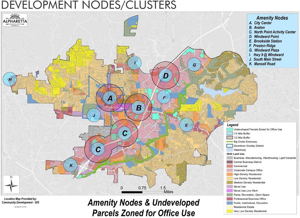
10 DEVELOPMENT NODES/CLUSTERS

11 DEVELOPMENT NODES/CLUSTERS
12 Topics for 2016 Comp. Plan Update MULTIPLE SCALES- Mixed Use Zoning Applicable to properties located within: Areas that are primarily non-residential in character Along major roadways that are primarily commercial in character Historic Downtown Alpharetta As noted in the Comprehensive Land Use Plan Minimum Lot Size: The minimum area permitted to be zoned for an MU development is 25 acres. MU Zoning District was revised and adopted March 2, 2015 to include a park land goal: Each MU development shall set a goal to provide a minimum of acre of park land/100 population generated by residential uses.

13 Topics for 2016 Comp. Plan Update MULTIPLE SCALES- Mixed Use Zoning Dwelling, attached or detached: At least 25% of the MU development shall be utilized as residential dwellings. Dwelling, For-Rent units shall require conditional use approval. Commercial: At least 25% of the MU development shall be utilized as commercial uses (as approved in the MU master plan). Public Space: A minimum of ten percent (10%) of the gross land area must be designed for public use as recreation, entertainment and/or civic space. Office/Institutional: At least 25% of the MU development shall be utilized for office buildings.
.")
14 EAST-WEST BALANCE

15 Topics for 2016 Comp. Plan Update EAST-WEST BALANCE Total Residential Subdivisions: 283 Housing Type West East Single-Family Detached Townhouse 16 2 Condominium 15 2 Apartment TOTAL

16 Topics for 2016 Comp. Plan Update PRESERVING RESIDENTIAL AREAS AND CITY CHARACTER Current language (how designed): Maintain a balance between residential buildings designed for sale and residential buildings designed for rent in Alpharetta such that at least 85% of the housing stock is for sale. Currently at 76% for sale and 24% for rent by design Proposed language (Census): Maintain a balance between residential buildings occupied as for sale and residential buildings occupied as for rent in Alpharetta such that at least 68% of the housing stock is for sale. Currently at 64% for sale using May 2015 Census data
: Maintain a balance between residential buildings occupied as for sale and")
17 Reality Check-Lite Exercise Urban Land Institute s (ULI s) Reality Check exercise: Visioning exercise that allows participants to allocate expected growth using chips (or Legos) on large maps to ask: How should we grow? Where should we grow?
 on large maps to ask: How should we grow?")
18 Reality Check-Lite Exercise Use the chips on your tables to help determine where future growth should be focused in Alpharetta: Blue chips for Office Orange chips for Residential Red chips for Retail When you ve mapped your clusters of development, use markers to illustrate any priority transportation corridors needed to support this development.

19 GREENSPACE

20 Topics for 2016 Comp. Plan Update SUSTAINABILITY City Council approved 2 Green Ordinances in 2009 and 2010, which include optional and required green regulations for both public and private sectors The City has maintained the Gold Level of ARC s Green Communities program since Was most recently recertified in January 2015

21 Greenway Mapping Exercise The City has a solid spine of multiuse trails with the Big Creek Greenway. Where and what type of additional greenspaces are needed Think about the destinations and amenities you would like to be connected via a greenway spur or expansion Map 2 to 3 of these connections onto the Greenspace map
22 Priority Thought Wall Exercise To be successful in the future, Alpharetta must be a city for both young and old, as well as one that fosters the arts and cultural opportunities. On the thought wall, tell us what you think the City needs in the future to be a place for youth, a place for seniors, and a community that has a thriving arts and cultural presence.
23 Topics for 2016 Comp. Plan Update FUTURE TRANSIT? Transportation Policy 1: Increase transportation accessibility and mobility. Transportation Policy 7: Maintain active involvement in state and regional transportation planning activities.
24 Topics for 2016 Comp. Plan Update SCHOOLS/EDUCATION Community Services and Facilities Policy 4: Support an educational system that achieves a higher standard of learning and meets current and future population needs. Intergovernmental Coordination Policy 2: Promote partnerships between the City and county Board of Education.
25 Next Steps Public Meetings (March 16 and 24) Steering Committee Meeting #3 (March 31) City updates Comprehensive Plan Planning Commission review and Council approval in April/May
Attachment B Policy Audit Template
 Attachment B Policy Audit Template 5 6 7 8 9 0 Provide A Variety of Transportation Choices Provide A Variety of Transportation Choices Provide A Variety of Transportation Choices Encourage transit-oriented
Restoration. a brief look at
 Copyright 2009 Canin Associates, Inc. All rights reserved. No part of this publication may be reproduced or transmitted by any means without written permission from Canin Associates, Inc. a brief look
VANDERBILT COMPARISON
 Village of Vanderbilt Comparison One County, One Vision Master Plan (2000) 1 15 Improve recreation in Otsego County by assessing the availability and need to improve bike paths, county recreation facilities,
Zoning Districts, Gwinnett County, Georgia
 Zoning Districts, Gwinnett County, Georgia The zoning district descriptions in this section should be used as a guide only for the unincorporated areas of Gwinnett County. Before buying or selling property,
Citizen Advisory Group Meeting #1 December 8, 2011 6:00 p.m.
 Citizen Advisory Group Meeting #1 December 8, 2011 6:00 p.m. Meeting Agenda 1. Background Information 2. Policy Framework 3. Plan Development Process 4. Public Input Results 5. Vision Statement 6. Group
FUTURE LAND USE ELEMENT
 GOALS, OBJECTIVES AND POLICIES FUTURE LAND USE ELEMENT GOAL A THE CITY OF FORT WALTON BEACH WILL PLAN FOR AND PROVIDE A HIGH QUALITY OF LIFE TO MEET THE NEEDS OF THE CURRENT AND FUTURE POPULATION, PROVIDING
Rapid City Downtown Area Master Plan. Draft Plan Concepts April 2016
 Rapid City Downtown Area Master Plan Draft Plan Concepts April 2016 CALL TO ACTION! A Thriving Downtown = Regional Economic Prosperity Rapid City is competing nationally for a limited supply of young skilled
City of Arnold, Missouri
 City of Arnold, Missouri Business Brochure City of Arnold 2101 Jeffco Blvd. Arnold, MO 63010 Phone: 636-282-2378 Fax: 636-282-6677 E-mail: dbish@arnoldmo.org The City of Arnold is a suburban community
7.0 GOALS, OBJECTIVES & POLICIES
 7.0 GOALS, OBJECTIVES & POLICIES The following Goals, Objectives and Policies specific to Housing are organized into broad categories including: 7.1: Housing Availability 7.2: Protection of Existing Neighborhoods
Frederick. Frederick. Maryland. Smart Growth Successes. Frederick. Maryland Department of Planning
 Frederick Frederick Maryland Smart Growth Successes Frederick Maryland Department of Planning Smart, Green & Growing Martin O Malley Governor Anthony G. Brown Lt. Governor Maryland Department of Planning
Philadelphia County. Land Use and Growth Management Profile
 Philadelphia County is located in the southeastern corner of Pennsylvania and is bordered by the Pennsylvania counties of Delaware, Montgomery, and Bucks, and the New Jersey counties of Burlington, Camden,
January 2015 BrowardNext Summary Survey Results for Focus Area Priorities. Ranking of Focus Area Importance
 January 2015 BrowardNext Summary Survey Results for Focus Area Priorities Ranking of Focus Area Priorities for the Broward County Land Use Plan The graphic below illustrates the survey results for Focus
Chapter 13: Implementation Plan
 Chapter 13: 13.1. INTRODUCTION The purpose of the implementation chapter of the Comprehensive Plan is to set forth the actions that the City will take to ensure that the plans, programs and policies set
SECTION ONE CHAPTER 2: A LAND USE PROFILE OF MANCHESTER
 SECTION ONE CHAPTER 2: A LAND USE PROFILE OF MANCHESTER Land use is the central element of a comprehensive plan because it establishes the overall physical configuration of the city, including the mix
COUNTY OF ALBEMARLE PLANNING STAFF REPORT SUMMARY. Staff: Claudette Grant
 COUNTY OF ALBEMARLE PLANNING STAFF REPORT SUMMARY Project Name: ZMA 2013-00004 Hollymead Town Center Block VI Planning Commission Public Hearing: July 29, 2014 Staff: Claudette Grant Board of Supervisors
Presentation to Knox County Commission Monday, February 23, 2015
 The Northwest County Sector Plan Update Presentation to Knox County Commission Monday, February 23, 2015 COMMUNITIES OF THE NORTHWEST COUNTY SECTOR Ball Camp Cedar Bluff Last NW Sector Update: 2003 Land
9.0 Alta Vista/Faircrest Heights/Riverview Park (Key Principles)
") 9.0 Alta Vista/Faircrest Heights/Riverview Park (Key Principles) Official Plan Consolidation for the City of Ottawa 1 9.1 Location This Chapter applies to Alta Vista/Faircrest/Riverview Park, which corresponds
9.0 Alta Vista/Faircrest Heights/Riverview Park (Key Principles) Official Plan Consolidation for the City of Ottawa 1 9.1 Location This Chapter applies to Alta Vista/Faircrest/Riverview Park, which corresponds
COMMUNITY WORKSHOP #2
 COMMUNITY WORKSHOP #2 General Plan Elements Update April 28, 2015 Today s Agenda I. Project Purpose What Are We Doing and Why! II. What is a General Plan? III. Project Overview/Timeline IV. Community Input
A PPENDICES C OLLIERVILLE 2040 LAND USE PLAN UPDATE
 A PPENDICES C OLLIERVILLE 2040 LAND USE PLAN UPDATE Traditional Neighborhood Character Study with a Neighborhood Center Commercial Node Aldi s is appropriate in a Neighborhood Center School Greenbelt Trail
COUNTY OF ALBEMARLE PLANNING STAFF REPORT SUMMARY
 COUNTY OF ALBEMARLE PLANNING STAFF REPORT SUMMARY Project Name: ZMA 2010-00001 Pantops Ridge Planning Commission Public Hearing: January 11, 2011 Owners: Richard T. Spurzem Acreage: 37.5 acres TMP: TMP
S. BLOCK 68 REDEVELOPMENT PROJECT AREA
 S. BLOCK 68 REDEVELOPMENT PROJECT AREA 1. Revitalization Project Description The Block 68 Redevelopment Project Area is located on the block bounded by 10 th, 11 th, M, and N Streets, and is comprised
SACRAMENTO COUNTY SUMMARY OF ZONING CLASSIFICATIONS
 SACRAMENTO COUNTY SUMMARY OF ZONING CLASSIFICATIONS This document provides a brief overview of zoning designations only. Inaccuracies may be present. Please consult the Sacramento County Zoning Code for
CITY OF LEHI, UTAH GENERAL PLAN MODERATE INCOME HOUSING ELEMENT
 CITY OF LEHI, UTAH GENERAL PLAN MODERATE INCOME HOUSING ELEMENT Prepared by: Lehi City Planning Department and Mountainland Association of Governments Adopted by Lehi City Council August 14, 2012 Recommended
Summary of Cities & Towns with Building Permit Allocation Systems
 Summary of Cities & Towns with Building Permit Allocation Systems The following is a review of six cities and towns across the country that have a growth management program limiting building permit allocations
Executive Summary. Does a Streetcar Make Sense in Anaheim
 Does a Streetcar Make Sense in Anaheim Streetcar in Portland s Pearl District Anaheim s proposed streetcar compares well with national best practice in Portland, Seattle and Tampa where new streetcars
Near West Side Comprehensive Plan Executive Summary (Revised) April 2004 City of Milwaukee DCD
 April 2004 City of Milwaukee DCD") Near West Side Comprehensive Plan Executive Summary (Revised) April 2004 City of Milwaukee DCD Boundaries The Near West Side Comprehensive Plan covers a broad area immediately west of Milwaukee s downtown.
Near West Side Comprehensive Plan Executive Summary (Revised) April 2004 City of Milwaukee DCD Boundaries The Near West Side Comprehensive Plan covers a broad area immediately west of Milwaukee s downtown.
Downtown South Salt Lake Redevelopment City of South Salt Lake
 Project Information LOCAL PLANNING RESOURCE PROGRAM 2015 Downtown South Salt Lake Redevelopment City of South Salt Lake Overview of Objectives: Building a downtown city center could be the most significant
BASSETT CREEK VALLEY MASTER PLAN OPEN HOUSE
 BASSETT CREEK VALLEY MASTER PLAN OPEN HOUSE February 23, 2006 PROJECT INTRODUCTION Project Area 230 acres $50 million estimated market value (approximately) 50 acres parkland 100 residences (estimated)
KEYPORT COMMUNITY PLAN
 PLANNING COMMISSION TASKS Collect Public Comments on Draft Plan. Provide Clear Direction for: Preferred LAMIRD Boundary Lot Clustering Provision View Protection Recommendation to Board of County Commissioners.
ALACHUA COUNTY COMPREHENSIVE PLAN 2011-2030
 ALACHUA COUNTY COMPREHENSIVE PLAN 2011-2030 Adopted April 5, 2011 (Ordinance 11-01, Effective July 22, 2011; Housing Element effective August 23, 2011) Updated through January 21, 2016 Alachua County Growth
Environment Virginia Conference April 6, 2011. Integrating Stormwater, Urban Design, and Growth Policies
 Environment Virginia Conference April 6, 2011 Integrating Stormwater, Urban Design, and Growth Policies Integrating Stormwater, Urban Design, and Growth Policies Sara Hollberg, AICP, Valley Conservation
Corridor Goals and Objectives
 Corridor Goals and Objectives This chapter presents the goals and objectives, developed by the Corridor Study Committee, that serve as the purpose and intent of the Corridor Plan. This plan covers a twenty
REDEVELOPMENT PLAN CITY OF LAWRENCEVILLE TAX ALLOCATION DISTRICT #2 COLLEGE CORRIDOR DRAFT DECEMBER, 2010. October 19, 2011
 CITY OF LAWRENCEVILLE TAX ALLOCATION DISTRICT #2 COLLEGE CORRIDOR DRAFT REDEVELOPMENT PLAN DECEMBER, 2010 October 19, 2011 Prepared for: City of Lawrenceville Prepared by: TABLE OF CONTENTS Table of Contents...
I I I I I I. 8. Encourage equitable taxation and assessment policies for
 6. Encourage the establishment of appropriate Agriculture Security Areas, under Act 43, as amended, consistent with local and county Comprehensive Plans. Care should be taken not to designate farmland
The Lancaster Medical District Master Plan. The Lancaster Campus District 1
 The Lancaster Medical District Master Plan The Lancaster Campus District 1 Table of Contents 1 INTRODUCTION 3 2 THE PLANNING PROCESS 4 Assumptions 6 3 PLANNING CONTEXT AND ECONOMIC OUTLOOK 7 Site Analysis
Smart Growth Illustrated: Developer s Guidebook. City of Bentonville Community Development Department October 2006
 Smart Growth Illustrated: Developer s Guidebook City of Bentonville Community Development Department October 2006 1 Table of Contents What is Smart Growth...3 Six Goals of Smart Growth 5 Ten Tools of Smart
Sharswood/Blumberg Choice Neighborhoods HOUSING TASK FORCE WORK SESSION #3
 Sharswood/Blumberg Choice Neighborhoods HOUSING TASK FORCE WORK SESSION #3 TUESDAY, AUGUST 26,2014 HAVEN PENIEL UNITED METHODIST 2301 W OXFORD STREET PHILADELPHIA, PA 19121 1 Welcome SHARSWOOD/BLUMBERG
Economic Development Element
 The Strawberry Ladies by Tara Stood Economic Development Element Economic development enhances San Clemente s quality of life by providing local goods and services and expanding employment and business
DENSITY AND PUBLIC SPACE AT BISHOP STREET
 DENSITY AND PUBLIC SPACE AT BISHOP STREET Niehoff Urban Studio Senior Planning Capstone Spring 2015 Justin M. Lightfield U N I V E R S I T Y O F C I N C I N N A T I Table of Contents Overview... 3 Design
Sandy. Comprehensive Land Use Plan. Adopted October 20, 1997 Ordinance No. 8-97. Comp Plan
 Sandy Comprehensive Land Use Plan Adopted October 20, 1997 Ordinance No. 8-97 http://www.ci.sandy.or.us/city_services/planning/comp_plan.htm (1 of 53)11/14/2005 7:23:44 AM City of Sandy 39250 Pioneer Blvd.
GUIDE TO ZONING CATEGORIES
 GUIDE TO ZONING CATEGORIES PRINCE GEORGE S COUNTY, MARYLAND THE MARYLAND-NATIONAL CAPITAL PARK AND PLANNING COMMISSION PRINCE GEORGE S COUNTY PLANNING DEPARTMENT COUNTY ADMINISTRATION BUILDING 14741 GOVERNOR
WHEREAS, Santa Monica is a coastal city in a prime location, being bordered by the City of Los Angeles to the north, east and south; and
 City Council Meeting / /2013 ORDINANCE NUMBER (CCS) (City Council Series) AN ORDINANCE OF THE CITY COUNCIL OF THE CITY OF SANTA MONICA AMENDING SANTA MONICA MUNICIPAL CODE SECTIONS 9.56.020, 9.56.030,
Public Survey for Phase I
 Rockfish Valley Area Plan: Public Survey for Phase I For Nelson County Residents & Property Owners Name: OPTIONAL: Location of residence or property: o Address: o Voting District: North Central West South
TABLE OF CONTENTS. Executive Summary 1-3. Introduction 4-6. Illustrative Site Plan 7. East-West Streets 8. Cooper Street 9-10. Market Street 11-14
 TABLE OF CONTENTS Executive Summary 1-3 Introduction 4-6 Illustrative Site Plan 7 East-West Streets 8 Cooper Street 9-10 Market Street 11-14 Federal Street 15-16 MLK Boulevard 17-20 North-South Streets
Land Use and Zoning. Land Use Within the Port Madison Indian Reservation
 Land Use and Zoning Land Use Within the Port Madison Indian Reservation A portion of the Suquamish Rural Village is Trust land, owned either by the Tribe or individual tribal members. The following list
Application 5. Countywide
 APPLICATION SUMMARY Application No. 5 Countywide Applicant/Representative: Location: Requested Text Changes: Amendment Type: Jack Osterholt, Deputy Mayor/Director Miami-Dade County Department of Regulatory
INTRODUCTION TO ZONING DISTRICT REGULATIONS
 INTRODUCTION TO ZONING DISTRICT REGULATIONS Classification of Zoning Districts Zoning districts in Dorchester County are categorized as Suburban Urban, Suburban Transition, or Rural. These districts are
PLANNING COMMISSION REPORT Regular Agenda - Public Hearing Item
 Z-15-00063 Item No. 1-1 PLANNING COMMISSION REPORT Regular Agenda - Public Hearing Item PC Staff Report 04/20/2015 ITEM NO. 1 Z-15-00063 CS TO RS5; 832 Ohio Street (BJP) Z-15-00063: Consider a request
Request for Information
 Request for Information Date of Issue: February 13, 2015 Responses Due: May 29, 2015 Overview Forest West Properties Inc. (FWP) is soliciting qualifications from qualified developers for the development
Chapter 7 ZONING PLAN
 Chapter 7 ZONING PLAN Introduction This Chapter opens with a general description of a zoning plan. It is followed by a brief explanation of the relationship between this Growth Management Plan and the
Cherokee County: Bells Ferry LCI Study & County Ordinance Audit. Prepared by Atlanta Regional Commission Staff 2006. Atlanta Regional Commission
 Cherokee County: Bells Ferry LCI Study & County Ordinance Audit Prepared by Atlanta Regional Commission Staff 2006 Atlanta Regional Commission 1 Document Review and Recommendations Introduction The objective
What we build today will create Denver s tomorrow. Signature development projects will strengthen our economy, create jobs and improve neighborhoods.
 Mayor Hancock s Vision for Building a World-Class City What we build today will create Denver s tomorrow. Signature development projects will strengthen our economy, create jobs and improve neighborhoods.
5 th Ward Alderman Neighborhood Representative Local media outlets
 . ACTION PLAN MATRIX Action Plan Matrix ACTION PLAN MATRIX Project Implementation Measure Project Leader / Potential Partners Time Frame Possible Funding Source Plan Reference Adopt Neighborhood Strategic
Market Summary. prepared by FXM Associates 6.1. North River Canal Corridor
 Market Summary prepared by FXM Associates North River Canal Corridor 6.1 6.2 North River Canal Corridor Introduction In order to provide a context for planning within the North Canal Neighborhood Corridor,
Planning for the future. building a great city, great neighbourhoods
 Planning for the future building a great city, great neighbourhoods Table of contents 1 Looking ahead 2.4 million Calgarians 2 Goals 3 Building a sustainable, connected city of great neighbourhoods 4 Finding
Introduction. Residential Development. Plan Foundation. Growth Management Concepts
 Introduction The land use element of the comprehensive plan created a roadmap for future growth and development patterns in the Village of Plain City. The plan designated areas for future residential,
The Trust for Public Land CREATING PARKS FOR PEOPLE CONNECTING CLEVELAND THROUGH PARKS AND TRAILS
 The Trust for Public Land CREATING PARKS FOR PEOPLE CONNECTING CLEVELAND THROUGH PARKS AND TRAILS Lake Link Trail Corridor Location/Context The Proposed Trail Corridor travels along vacated Road and Railroad
TABLE OF CONTENTS. INTRODUCTION...1 Purpose of a Comprehensive Plan...1 McKenzie County Comprehensive Plan...1 Definitions...2 Goal...2 Vision...
 MCKENZIE COUNTY COMPREHENSIVE PLAN TABLE OF CONTENTS INTRODUCTION...1 Purpose of a Comprehensive Plan...1 McKenzie County Comprehensive Plan...1 Definitions...2 Goal....2 Vision...3 ECONOMIC DEVELOPMENT...4
Appendix C Related Studies
 Appendix C Related Studies Intermodal Transit Village Concept Plan Appendix C Related Studies This appendix summarizes studies that are current at the time of this Plan. Intermodal Transit Village Concept
2010 Salida Community Priorities Survey Summary Results
 SURVEY BACKGROUND The 2010 Salida Community Priorities Survey was distributed in September in an effort to obtain feedback about the level of support for various priorities identified in the draft Comprehensive
CPED STAFF REPORT Prepared for the City Planning Commission
 CPED STAFF REPORT Prepared for the City Planning Commission CPC Agenda Item #1 June 23, 2014 RLS-72 LAND USE APPLICATION SUMMARY Property Location: 222 Hennepin Avenue Project Name: 222 Prepared By: Becca
AREA: 2.37 acres NUMBER OF LOTS: 1 FT. NEW STREET: 0 LF. Single-family, Non-conforming machine shop
 FILE NO.: Z-8958 NAME: Rock Structure Repair Short-form PID LOCATION: Located at 8024 Stanton Road DEVELOPER: Rock Structure Repair Attn. Rudy Gutierrez 3 Kipling Court Little Rock, AR 72209 ENGINEER:
FIRST READING BE IT ORDAINED BY THE CITY COUNCIL OF THE CITY OF AUSTIN:
 1 1 1 0 1 0 1 0 ORDINANCE NO. AN ORDINANCE AMENDING CITY CODE CHAPTERS - (ZONING) AND - (TECHNICAL CODES) RELATING TO THE REGULATION OF SHORT- TERM RENTAL RESIDENTIAL USES; AND WAIVING THE TECHNICAL BOARD
Blight Remediation & the Detroit Future City Plan
 Blight Remediation & the Detroit Future City Plan Detroit s blight is a key impediment to economic growth City has only budgeted $400 million over the next 10 years for remediation The Detroit Blight Removal
THE RUSKIN COMMUNITY PLAN
 THE RUSKIN COMMUNITY PLAN Introduction Ruskin is a historic community situated on the shores of Tampa Bay, the Little Manatee River and the Ruskin Inlet, approximately 16 miles southeast of Tampa. The
CITY COUNCIL / PLANNING COMMISSION JOINT STUDY SESSION AGENDA REPORT
 CITY COUNCIL / PLANNING COMMISSION JOINT STUDY SESSION AGENDA REPORT MEETING DATE: SEPTEMBER 8, 2015 ITEM NUMBER: 1 SUBJECT: PROPOSED GENERAL PLAN LAND USE ALTERNATIVE FOR THE YEAR 2015-2025 GENERAL PLAN
2015 CITY COUNCIL COMMITTEE ASSIGNMENTS
 2015 CITY COUNCIL COMMITTEE ASSIGNMENTS Commission Liaison (One Member) Community Services Commission Old Town Local Review Board Planning Commission Public/Traffic Safety Commission Current Member McCracken
Residential Market. Downtown Houston
 Downtown Houston The Houston Market Houston s residential market represents one of the best values in the United States. The city ranks third in the 2010 Forbes list of best housing markets, and second
Proposed Planning Incentives to Support the Replacement of Office Space in New Mixed Use Developments Draft Zoning By-law Amendments
 PG12.5 STAFF REPORT ACTION REQUIRED Proposed Planning Incentives to Support the Replacement of Office Space in New Mixed Use Developments Draft Zoning By-law Amendments Date: April 18, 2016 To: From: Wards:
Neighborhoods & Housing
 Chapter 6 Neighborhoods & Housing Introduction A major goal of this plan is to improve the livability of the City s neighborhoods. For existing neighborhoods, this may be achieved through conservation,
Recycling andlargement of Comprehensive Plans in Miami-Dade County
 Ciity of Corall Gablles 2010 Comprehensive Plan ADM GOV FLU DES COM HOU EDU MOB NAT REC HIS SAF CIE GRN Table of Contents - Comprehensive Plan Elements ADM GOV FLU DES COM HOU EDU MOB NAT REC HIS SAF CIE
21.04 LAND USE. Managing amenity through land use strategies
 21.04 LAND USE This section contains objectives and strategies for land use, under the themes of: Housing and community Retail, entertainment and the arts Office and commercial use Industry Education and
S U S TA I N A B L E C O M M U N I T I E S : EAST NEW YORK
 S U S TA I N A B L E C O M M U N I T I E S : EAST NEW YORK REGIONAL ACCESS MIDTOWN 30 40 mins (A) LOWER MANHATTAN 18 25 mins (A) JAMAICA 9 Mins (LIRR) NASSAU CENTER 32 mins (LIRR) DOWNTOWN BROOKLYN 15-20
IMAGINE FLINT MASTER PLAN FOR A SUSTAINABLE FLINT Goals and Objectives
 IMAGINE FLINT MASTER PLAN FOR A SUSTAINABLE FLINT Goals and Objectives Adopted October 28, 2013 The City of Flint s Imagine Flint Master Plan for a Sustainable Flint is a blueprint for the future, guiding
How To Improve Housing In Seminole County
 ELEMENT Introduction Issues and Concerns Goals, Objectives and Policies Exhibits 2020 ELEMENT INTRODUCTION Since populations group themselves into households, the socioeconomic makeup of those households
FORT ORD MASTER PLAN GREATER MONTEREY PENINSULA AREA PLAN
 FORT ORD MASTER PLAN GREATER MONTEREY PENINSULA AREA PLAN DESCRIPTION The purpose of this plan is to designate land uses and incorporate objectives, programs, and policies to be consistent with the Fort
Draft Goals and Objectives Wadena Comprehensive Plan City of Wadena, Minnesota. Land Use Goals:
 Draft Goals and Objectives Wadena Comprehensive Plan City of Wadena, Minnesota Land Use Goals: 1. Growth in Wadena will be undertaken in such a manner as to create a full range of living, working, shopping,
 INTRODUCTION As part of a statewide realignment of due dates for updating local comprehensive plans, the Georgia Department of Community Affairs (DCA) is requiring partial updates as an interim step for
100% LEASED - FLEX INDUSTRIAL BUILDING
 1012 Airpark Drive Sugar Grove, IL 60554 PRESENTED BY: PROPERTY HIGHLIGHTS 45,000 SF Industrial Flex Building 2001 Masonry Construction 100% Leased to 3 Tenants Potential for up to 8 Units 4 Docks - 9
Comprehensive Plan Policies that support Infill and Mixed Use
 Comprehensive Plan Policies that support Infill and Mixed Use Introduction A comprehensive plan provides a broad vision for the future growth of a community. It is often formulated using community visioning
VISION, DESIGN PRINCIPLES & OVERALL PLANNING STRATEGY
 3 VISION, DESIGN PRINCIPLES & OVERALL PLANNING STRATEGY The overall planning strategy for the Bank Street CDP is to ensure that future development is undertaken in a coordinated and planned approach, supported
Introduction to Property Management
 Introduction to Property Management PROPERTY MANAGEMENT In general, property management includes tenant placement, maintenance and repairs, and the ongoing administration of real property. Tenant placement
Revere Beach Transit-Oriented Development Parcels Revere, Massachusetts. Design and Development Guidelines. Part Two.
 Revere Beach Transit-Oriented Development Parcels Revere, Massachusetts Design and Development Guidelines Request for Qualifications and Expressions of Interest with Preliminary Development Plans Part
Rezoning case no. RZ15-08: Adam Development Properties, LP
 PLANNING AND ZONING COMMISSION STAFF REPORT June 4, 2015 Rezoning case no. RZ15-08: Adam Development Properties, LP CASE DESCRIPTION: LOCATION: a request to amend the development plan of a previously-approved
SOUTH ELM DEVELOPMENT GREENSBORO, NC. June 28, 2012
 SOUTH ELM DEVELOPMENT June 28, 2012 The Excitement Has Started SOUTH ELM DEVELOPMENT Site Attributes Walkable Amenities Building Program The South Elm Street redevelopment area is the southern gateway
City of North Liberty, Iowa Comprehensive Plan
 City of North Liberty, Iowa Approved November 2013 2013 North Liberty Acknowledgments Table of Contents Page Introduction 2 Where We re at Today ning 3 Current Land Use 3 Population Estimates 4 Significant
Benzie County Master Plan Survey Results Summary and Report
 August 31, 2015 Benzie County Master Plan Survey Results Summary and Report As part of the 2015 Benzie County Master Plan update, the Benzie County Planning Commission and the Master Plan Committee developed
PINELLAS COUNTY COMPREHENSIVE PLAN
 PINELLAS COUNTY COMPREHENSIVE PLAN Future Land Use Map (FLUM) Category Descriptions and Rules Amended March 17, 2009 (Ordinance 09-17) Amended March 16, 2010 (Ordinance 10-18) Amended October 26, 2010
City Code of ANN ARBOR, MICHIGAN Chapter 55 Zoning
 ARTICLE II. USE REGULATIONS 5:10.2. R1A, R1B, R1C, R1D single family dwelling district (1) Intent. (a) These single family residential districts are designed to provide an environment of predominantly
1 2 3 4 Appendix A Appendix B Appendix C
 1 2 3 4 Appendix A Appendix B Appendix C Introduction This chapter provides the foundation for the Comprehensive Plan, outlining why we plan, the planning process, Smart Growth Planning, and the planning
Downtown Core Sub-district
 3-10 Land Use Downtown Core Sub-district District development will be most intense and most urban in character in the Downtown Core. The objective is to establish this area as a citywide and regional retail
Indianapolis SDAT. Neighborhood Restoration
 Neighborhood Restoration Working Toward a Sustainable Future live * work * play October 30 th, 2009 Message Hear concerns Build consensus Provide Recommendations Transition from Fragmentation/disconnect
Downtown Tampa Transportation Vision
 Downtown Tampa Transportation Vision Executive Summary August 1, 2006 Hillsborough County Metropolitan Planning Organization County Center, 18 th Floor Tampa, Florida 33602 813-272-5940 www.hillsboroughmpo.org
Conducting a Land Use Inventory
 Chapter 3 Conducting a Land Use Inventory Included in this chapter: Determining Current Land Use Conditions Preparing a Base Map Deciding on Land Use Categories Collecting Current Land Use Data Preparing
Village of Royal Palm Beach
 Village of Royal Palm Beach Comprehensive Plan Comprehensive Plan Adopted 2009 Village of Royal Palm Beach Page 1 Table of Contents Introduction Page 3 Future Land Use Element Page 4 19 Future Land Use
MILWAUKEE. Plan. comprehensive DEPARTMENT OF CITY DEVELOPMENT MARCH, 2010 EXECUTIVE SUMMARY
 MILWAUKEE Plan DEPARTMENT OF CITY DEVELOPMENT MARCH, 2010 comprehensive CITYWIDE POLICY PLAN EXECUTIVE SUMMARY INTRODUCTION AND OVERVIEW I. OVERVIEW OF COMPREHENSIVE SMART GROWTH PLAN SERIES The series
1. Land Use. Chapter 1: Land Use 1-1 Adopted 10/2/09 Amended 3/22/11, 8/16/11
 1. Land Use Minneapolis will develop and maintain a land use pattern that strengthens the vitality, quality and urban character of its downtown core, commercial corridors, industrial areas, and neighborhoods
City of Tampa Zoning Districts
 City of Tampa Zoning Districts The city is divided by chapter 2 into zoning districts, the boundaries and designations of which are shown in a series of maps, covering in combination the entire land and
STAFF REPORT. December 20, 2004. North District Community Council. Director of Community Planning - North
 STAFF REPORT December 20, 2004 To: From: Subject: North District Community Council Director of Community Planning - North Preliminary Report Respecting Revised Application OPA & Rezoning Application 01
TOWN OF CARY CONDITIONAL USE ZONING PERMIT. 412 Rutherglen Cary, NC 27511-6437. 412 Rutherglen Cary, NC 27511-6437
 TOWN OF CARY CONDITIONAL USE ZONING PERMIT PETITION: PETITIONER(S): OWNER(S): LOCATION: 01-REZ-16 204 N. Dixon Avenue, Cary, NC PARCEL IDENTIFICATION: 076418218784 REALID: 0031004 AREA: APPROVED ZONING: