ENHANCED CONCEPTUAL PROGRAM FOR A NEW HAVEN TRAFFIC OPERATIONS CENTER
|
|
|
- Doreen Chapman
- 10 years ago
- Views:
Transcription
1 I-95 OPERATIONS AND TRAFFIC MANAGEMENT ON-CALL TECHNICAL MEMORANDUM ENHANCED CONCEPTUAL PROGRAM FOR A NEW HAVEN TRAFFIC OPERATIONS CENTER PREPARED FOR SOUTH CENTRAL REGIONAL COUNCIL OF GOVERNMENTS by DUNN ENGINEERING ASSOCIATES, P.C. in association with CLOUGH HARBOUR & ASSOCIATES LLP URBITRAN ASSOCIATES, INC. June 2007

2 EXECUTIVE SUMMARY A Traffic Operations Center (TOC) to be operated by the New Haven Department of Traffic and Parking is recommended to facilitate corridor operations in the New Haven area. While management of traffic in connection with the Harbor Crossing Corridor Improvement Program is an initial function, the TOC will serve to manage operations after construction is complete. The TOC will operate in close conjunction with the Connecticut Department of Transportation (ConnDOT) TOC in Bridgeport, and will exchange information with other key stakeholders. Existing and proposed field equipment will support this operation. A significant reduction in delays to motorists resulting from incidents or construction is expected. Congestion monitoring, more rapid incident clearance, implementation of diversion plans and motorist information will provide this improvement. Signal timing on diversion routes will be adjusted to better service diverted traffic resulting from incidents. Provision of congestion information to emergency service responders will enable them to perform their missions with less delay. Preliminary diversion routes to carry interstate traffic around the Pearl Harbor Memorial Bridge are identified in Section 2.2 of this Technical Memorandum, and must be reviewed by stakeholders. Congestion will be identified by traffic detectors, and diversions will be supported by variable message signs, highway advisory radio, dynamic trail-blazers, static trail-blazers and web site information. Congestion information developed by the TOC will also be provided in a concise and rapid format to emergency service providers. ConnDOT currently operates much of the required equipment, however, additional field equipment will be required. The project requires close cooperation among the major stakeholders including: New Haven Department of Traffic and Parking Connecticut Department of Transportation New Haven Fire Department New Haven Police Department North Central Connecticut EMS Council South Central Regional Council of Governments Town of East Haven Harbor Crossing Corridor Improvement Program With stakeholder participation and approval, a Concept of Operations will be developed to define and coordinate project activities and information flows.

3 Estimated project costs in thousands of dollars are summarized below: New Haven TOC and Field Equipment Connecticut DOT Field Equipment Total Construction $2,400 $640 $3,040 Annual Operations and Maintenance During Bridge Reconstruction $630 $60 $690 Annual Operations and Maintenance After Bridge Reconstruction $490 $60 $550 The concept of using existing ConnDOT capabilities in conjunction with local corridor management represents a significant enhancement to current ITS capability, and may serve as a demonstration for metropolitan areas in Connecticut with similar requirements.

4 TABLE OF CONTENTS EXECUTIVE SUMMARY 1. INTRODUCTION ENHANCED CONCEPTUAL PROGRAM FOR A NEW HAVEN TRAFFIC OPERATIONS CENTER TOC REQUIREMENTS OBJECTIVES FUNCTIONAL REQUIREMENTS ALTERNATE ROUTES AND MOTORIST INFORMATION CONCEPTS GENERAL DIVERSION APPROACH DIVERSION ROUTES FUTURE CONSIDERATIONS FOR DIVERSION PLANNING NEW HAVEN TRAFFIC OPERATIONS CENTER FUNCTIONS TOC PHYSICAL REQUIREMENTS EQUIPMENT REQUIREMENTS PHYSICAL SPACE REQUIREMENTS STAFFING REQUIREMENTS FIELD EQUIPMENT DEPLOYMENTS DEPLOYMENT PLAN FOR FIELD EQUIPMENT SURVEILLANCE EQIPMENT MOTORIST INFORMATION AND CONTROL EQUIPMENT TRAFFIC SIGNAL CONTROL SYSTEM EFFECTIVENESS EMERGENCY VEHICLE ACCESS COST INTERAGENCY DATA FLOW AND INSTITUTIONAL RELATIONSHIPS CONCLUSIONS AND RECOMMENDATIONS CONCLUSIONS NEAR TERM RECOMMENDATIONS LONG TERM RECOMMENDATIONS 32 EXHIBITS 2-1 ALTERNATE ROUTE I-95 SB TO I-91 NB ALTERNATE ROUTE I-95 SB TO I-95 SB ALTERNATE ROUTE I-95 NB TO I-91 NB ALTERNATE ROUTE I-95 NB TO I-95 NB ALTERNATE ROUTE I-91 SB TO I-95 NB ALTERNATE ROUTE I-91 SB TO I-95 SB. 15

5 EXHIBITS (CONTINUED) 2-7 PRELIMINARY INFORMATION FLOW CONCEPT OPERATIONS AREA DELAY IMPROVEMENT (VEH HR) FOR NON-DIVERTING VEHICLES DELAY PER VEHICLE IMPROVEMENT (MIN) FOR NON- DIVERTING VEHICLES NEW HAVEN ITS ESTIMATED PROJECT COST INFORMATION FLOW BETWEEN NEW HAVEN TOC AND OTHER STAKEHOLDERS (PRELIMINARY) 30 APPENDICES A PRELIMINARY DISPLAY EQUIPMENT DEPLOYMENTS 33 B PROJECT COST 37 C EMERGENCY VEHICLE ACCESS AND DELAYS MINUTES OF MEETING 39
 30 APPENDICES A PRELIMINARY DISPLAY")
6 1. INTRODUCTION This study evaluates opportunities to respond to the congestion impacts of the Pearl Harbor Memorial Bridge Project. The results of the following tasks are reported in this Technical Memorandum (TM). Development of an Enhanced Conceptual Program for a New Haven Traffic Operations Center (TOC) Evaluation of Variable Message Signs, Highway Advisory Radio and other Intelligent Transportation System Measures Evaluation of Emergency Vehicle Access and Delay The interstate sections centering on the Pearl Harbor Memorial Bridge experience recurrent congestion during peak periods and at other times. Incidents commonly result in severe delays. These delays will become more frequent during bridge construction periods. The study concludes that traffic congestion will be improved by servicing the major demands as a traffic corridor managed by an Intelligent Transportation System (ITS). Thus, the focus of the New Haven TOC and ITS is to support the corridor management concept. The Connecticut Department of Transportation (ConnDOT) traffic management system contains surveillance and motorist information technology for detecting traffic congestion, and communicating delays and diversion recommendations to motorists. Additions to existing equipment are required in some locations to perform the functions required by this project. ConnDOT traffic detector and CCTV information will be provided to the New Haven TOC. The New Haven TOC will use this information, along with incident information and additional detector information to implement corridor functions. It will provide information on alternate routes and will assist in providing support to emergency responders. Signal timing plans to support diversions will also be provided. Congestion information will be provided to emergency service responders to facilitate improved routing under congestion conditions. Section 2 of the TM identifies the functions of the New Haven TOC, describes preliminary diversion routes and describes ITS processes to be implemented. Section 3 provides the TOC equipment, space and staffing requirements. Section 4 describes the existing and proposed field equipment and relates it to the diversion routes. It also describes the management requirements and controls associated with diversion and their expected effects. Section 5 discusses possible ways to improve measures for improving emergency vehicle access. Section 6 provides the estimated project cost. 1

7 Section 7 identifies the stakeholders, describes the importance of agreement for coordination of operations among the stakeholders and proposes a Concept of Operations as a mechanism to define interagency relationships. Section 8 provides conclusions, near-term recommendations and long-term recommendations. 2

8 2. ENHANCED CONCEPTUAL PROGRAM FOR A NEW HAVEN TRAFFIC OPERATIONS CENTER (TOC) 2.1 TOC REQUIREMENTS OBJECTIVES The TOC will serve to control traffic in the I-95 Corridor, and to assist in incident management operations both during and after the construction periods associated with the Harbor Crossing Corridor Improvement Program. Currently ConnDOT has surveillance and motorist information equipment on I-95, motorist information equipment on I-91, and plans for additional surveillance equipment. The New Haven TOC will implement diversion plans (related to specific alternate routes) utilizing this equipment, together with additional equipment to be provided, and signal timing plans that support the diversion plans. The TOC will also assist emergency service providers to more rapidly access and clear incidents. The system will provide motorists with a higher level of information on diversion routes during periods of construction related to the I-95 Harbor Crossing Corridor Improvement Program and after construction is complete. It is expected that these measures will result in the following benefits over and above those currently being provided by the ConnDOT ITS: Reduction of motorist delay by 20% resulting from incidents on I-95 or construction associated with the Pearl Harbor Memorial Bridge. Reduction of secondary accidents by 10% resulting from incidents on I-95 or construction associated with the Pearl Harbor Memorial Bridge. Reduction of delay to emergency responders by 20% FUNCTIONAL REQUIREMENTS The key functions of the New Haven TOC include the following: Monitor traffic conditions and reports of incidents and congestion on I-95 and I- 91. Verify and classify incidents. Select and implement response plans. Develop corridor based traffic management plans that are intended to respond to delays due to construction, incidents and special events. Coordinate the ITS implementation of management plans with plans developed by the Connecticut DOT, State Police and local police departments. Monitor New Haven traffic signals for appropriate signal timing plan selection and signal failure. 1 Update normal and diversion timing plans for the City of New Haven traffic signals. 1 1 Functions currently performed by the New Haven Department of Traffic and Parking. 3

9 Coordinate maintenance activities for the City of New Haven traffic signals ALTERNATE ROUTES AND MOTORIST INFORMATION CONCEPTS GENERAL DIVERSION APPROACH Diversion provides benefits to both those diverted (reduced travel time), and those remaining on the interstates (reduced demand resulting in considerably greater delay reduction). Thus, from the TOC s viewpoint, diversion is a tool to reduce total delay. High levels of diversion are not necessarily required to obtain significant delay reduction. To successfully accomplish this objective requires some level of control to assure that those diverted are not penalized in terms of longer travel time on the alternates. Diversion to the alternates will also affect local vehicles on those routes, and this effect must also be bounded. De facto diversion is the current situation on the interstates. De facto diversion occurs when a motorist messaging technology such as an upstream variable message sign (VMS) indicates congestion, but does not suggest an alternate. Thus some local motorists will divert to alternates appropriate to their destination. Some through motorists familiar with the area will divert; however most through motorists are likely to be unfamiliar with the alternates and will remain on the interstate. Other VMS will advise diversion on the planned diversion routes. Research has shown that diversion levels are a function of the strength of the message. To control the level of diversion on planned diversion routes, or at least to prevent overdiversion for the reasons cited above, travel time will be monitored on the interstates by using point detectors. Data from detectors on I-95 and I-91 will soon be available; however coverage gaps will exist and additional detectors will be required. Point detectors will also be required on the alternate routes at capacity critical locations. Point detectors will be used in conjunction with Synchro models or other simulations to estimate alternate route travel time and the volume to capacity ratio for diversion control purposes. Motorists unfamiliar with the area will require additional guidance to navigate the planned diversion routes. Additional guidance will be provided in the form of dynamic trail-blazers and static (conventional) trail-blazers. Dynamic trail-blazers are signs, portions of which or all of which may be illuminated or blanked out by controls from the TOC. They will be provided at the exit ramps for planned diversion routes. They will also be provided at turning points near the start of the planned diversion route. Further along the planned diversion route, static trail-blazers will be provided. Static trail-blazers are provided where the diversion route is also the best path to the interstate under nondiversion conditions. In some cases it may be required to replace existing static trailblazers with dynamic trail-blazers. Diversion signal timing plans will be used when a planned diversion is in effect and the signals are under closed loop control. Existing 1 Functions currently performed by the New Haven Department of Traffic and Parking. 4

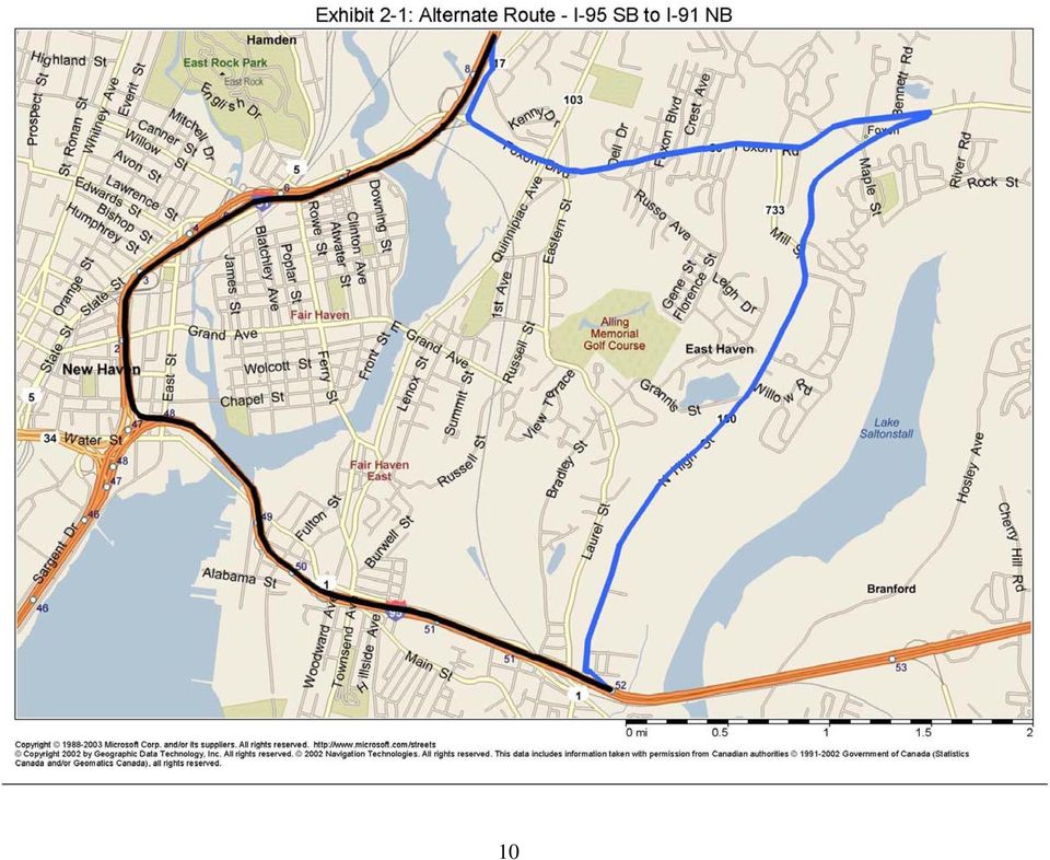
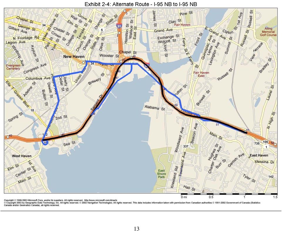
10 highway advisory radio (HAR) facilities will serve as a supplement to the VMS. An additional HAR beacon may be required. In the New Haven area, HAR coverage extends to the areas off the interstates. Thus it may be possible to use the HAR to advise local motorists of congestion prior to entering the interstates. It is envisioned that congestion on the planned diversion routes will be continuously monitored, and the diversion messages adjusted to maintain the level of service on these routes at an acceptable level. It should be noted that video processing detectors (a particular type of point detector) not only provide volume, lane occupancy and speed data, but also provide video images, thus enabling the TOC operator to override the controls if necessary DIVERSION ROUTES The following is proposed as an initial approach for diversion routes to address the effects of construction impacts and traffic incidents in the area of the Pearl Harbor Memorial Bridge. This approach must be reviewed with the City of New Haven and the Town of East Haven. Exhibits 2-1 through 2-6 show these routes. I-95 SB For congestion starting at Exit 49 and extending to any exit up to and including Exit 55, congestion notification for de facto diversion will be provided by the existing VMS between Exits 57 and 56. The planned diversion routes will start at Exit 52. Diversion will be recommended by the existing VMS between Exits 53 and 52. Motorists on US 1 will also be notified by the existing VMS at the Branford Connector. Traffic destined for I-91 NB north of New Haven will utilize Route 100 to Route 80 to Route 17 to I-91 Exit 8. Traffic destined for I-95 SB will utilize US 1 to Brewery Street to Sargent Drive to I-95 Exit 47. I-95 NB Information for planned diversion routes will be provided by the existing VMS south of Exit 43 and south of Exit 46. For congestion starting at Exit 48 and extending to Exit 45 or 44, the planned diversion route starts at Exit 44 and includes Kimberly Avenue, Howard Avenue and US 1. Traffic destined for I-91 NB will follow South Church Street to Church Street to Elm Street to State Street and enter I-91 at Exit 3. 5

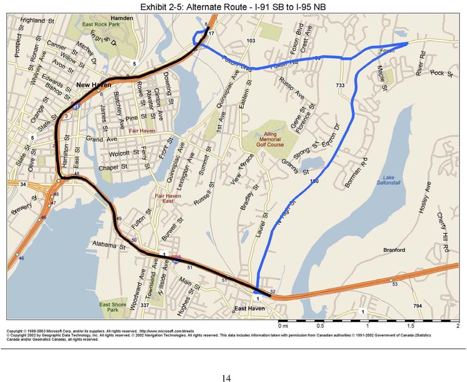
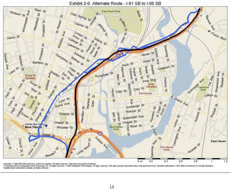
11 Traffic destined for I-95 NB will continue on US 1 to I-95 Exit 51. For congestion starting at Exit 48 and extending to Exit 46 the planned diversion route starts at Exit 46 and includes Long Wharf Road. and East Street. Traffic destined for I-95 NB will take US 1 to I-95 Exit 51. Traffic destined for I-95 N will continue on East Street. to Ives Place to I-91 Exit 2. I-91 SB to I-95 NB Congestion information for de facto diversion will be provided by the existing VMS north of Exit 12. The VMS south of Exit 9 will provide information for the planned diversion route. For congestion starting at I 95 and extending to any interchange up to Exit 8 the planned diversion route starts at Exit 8 and includes Middletown Avenue, Route 80 and Route 100 to I-95 Exit 52. I-91 SB to I-95 SB Congestion information for de facto diversion will be provided by the existing VMS north of Exit 12. The VMS south of Exit 9 will provide information for the planned diversion route. The congestion conditions and planned diversion routes are shown below. NON- DIVERSION ROUTE CONGESTION CONDITION Queue starts Queue ends I-91S to I-95S I-95 Exit 3 or 4 DIVERSION EXIT DIVERSION ROUTE 4 Humphrey St., State St., W. Water St., S. Orange St., Route 34 to I-95S. I-91S to I-95S I-95 Exit 6 6 Willow St., State St., W. Water St., S. Orange St., Route 34 to I-95S. I-91S to I-95S I-95 Exit 7 7 Middletown Ave., Ferry St., State St., W. Water St., S. Orange St., Route 34 to I-95S. I-91S to I-95S I-95 Exit 8 8 Middletown Ave., Ferry St., State St., W. Water St., S. Orange St., Route 34 to I-95S. 6

12 The Connecticut Department of Transportation, in conjunction with the State Police and local police departments, has identified diversion route plans for other locations along I- 95. These plans generally address closures at a point, and are intended to circumvent the closed location. The plans generally divert traffic at the exit ramp just upstream of the incident and return it to the entry ramp on I-95 downstream of the incident. These plans do not address the plans associated with the Pearl Harbor Memorial Bridge described above FUTURE CONSIDERATIONS FOR DIVERSION PLANNING The diversion routes described in Section are preliminary. The following must be accomplished to confirm the diversion route plan: Discussion of the control concept and the planned diversion routes with the City of New Haven and the Town of East Haven is required. The proposed approach, even after review, is preliminary in the sense that the impacts on the interstate and limitations on diverted volume must be determined under representative lane closure and incident conditions. The benefits for diversion must also be identified. These determinations are best accomplished by the use of simulations that model the interstate and planned diversion route impacts. The simulation can also help to identify the need and impact of such controls as ramp closures at Exits 51 and 49 to prevent queue jumping. 2.3 NEW HAVEN TRAFFIC OPERATIONS CENTER FUNCTIONS Section identifies key TOC functional requirements. The functions to be performed by the TOC to satisfy these requirements include: 1. Coordinate the development and updating of traffic response plans Draft plans in response to incidents, planned construction activity and special events will be developed and reviewed by stakeholders. The plans will be electronically documented and implemented by stakeholders. The plans will be stored in the TOC server for real time implementation. The use of simulation may assist in the development of traffic response plans. The roadway closure plans developed by ConnDOT together with the State Police and local police departments will be incorporated. Traffic response plans relate the location and nature of the event to the following controls and displays: VMS and HAR messages HAR beacons Dynamic trail-blazers 7

13 Entry ramp gate control systems including motorist warning devices 2 Traffic signal diversion timing plans. This includes City of New Haven and ConnDOT signals 2. Receive, process, display and communicate traffic related conditions Exhibit 2-7 shows a preliminary flow concept for information entering and leaving the New Haven TOC, and how this information relates to other field devices and stakeholders. These information flow relationships are further discussed in Section 7. CCTV and traffic detector information will be received from ConnDOT. Construction information will be obtained from the I-95 Harbor Crossing Improvement Program, from ConnDOT and from the City of New Haven. Incident information will be obtained from the New Haven 911 Communications Center in the form of 911 calls that have been entered into the management system and filtered for traffic incident information. Incident information will also be obtained from ConnDOT. Traffic detector speed data from ConnDOT on I-95 and I-91 will illuminate a traffic condition map. Additional detectors on these interstates as described in Section will be required. City of New Haven detector data will also be displayed. The condition map will also identify the location of traffic incidents. The map will be provided to emergency vehicle responders by rapid, low cost communications. This display will be provided to the public on the City of New Haven website and will be available to ConnDOT and Harbor Crossing Project web sites. ConnDOT CCTV images and City of New Haven traffic cameras will be available for display in the New Haven TOC and will be rapidly accessible to emergency service providers and to the New Haven Harbor Crossing Improvement Program. 3. Implement traffic response plans Traffic response plans will be implemented based on the information described above. Implementation of response plans involves the following: Scheduling of planned construction and special events. Verification and classification of incidents and congestion. Request for stakeholders to implement plans including notification to ConnDOT. It is expected that ConnDOT will implement messages on VMS and HAR, and will select appropriate signal timing diversion plans for its closed loop systems. Control of equipment not controlled by ConnDOT including the New Haven traffic signals, dynamic trail-blazers and entry ramp gate control equipment (if appropriate). 2 Use of gates annd associated equipment to be determined by later studies. If used, gates must be under CCTV surveillance and a motorist warning system must be provided for gate closure. 8

14 Provide notification to stakeholders as to when the plan should be terminated. 4. Assist emergency responders TOC operators may assist emergency responders to access the incident site and to assist them in managing traffic at the site with the ability to monitor traffic conditions, 5. Develop signal timing plans for the City of New Haven and coordinate maintenance of these signals. 9

15 10
16 11

17 12

18 13
19 14
20 15
21 EXHIBIT 2-7 PRELIM IN ARY INFO RM ATION FLO W CON CEPT BOS 911 Communications Ind. Serv. Provider, Media VMS PG Center HARB CLS HARB WS VD New Haven TOC ConnDOT TOC CWFM Det DT CWFM Det CCTV Harbor Crossing Corridor Improvement Program Emergency Service Responders CLS WS Device Symbols BOS Blank out sign CCTV CCTV camera CLS Closed loop traffic controller CWFM Det Continuous wave frequency modulated traffic detector D T Dynam ic Trailblazer HARB H ighway advisory radio beacon PG Protected gate VD V ideo based traffic detector VMS Variable message sign WS Web site Data Flow Functions Detector Data CCTV Signal Response Plan Control Traffic Inform ation Inform ation Input for R esponse Plan S ele ctio n R equest for C ontrol A ssistance Site or Device O utlines Existing Site or Device Proposed Site or Device Requires Additional Consideration 16
22 3.1 EQUIPMENT REQUIREMENTS 3. TOC PHYSICAL REQUIREMENTS The following is a preliminary estimate of the equipment required: 1. Existing Servers for the City of New Haven traffic signal control systems. 2. Server for the Event Management System. This server provides the intelligent management functions. These functions are expected to include: Receiving traffic detector and incident information from ConnDOT. Logging and displaying detector and incident information and traffic condition information, including detector information as available from the City of New Haven traffic signal control systems. Storage of event management plans and provision for operator selection, monitoring and management of plans. Communication of incident management plans to stakeholders. Control of alternate routing devices not controlled by ConnDOT. Provision of incident management information to media and independent service providers. Display of dynamic message sign messages. Gate controls and associated messages (if appropriate). 3. Workstations for the traffic signal systems and the event management system. 4. Workstation/monitor for information from New Haven 911 Communication Center. 5. Video wall for the display of CCTV cameras, traffic condition and equipment condition maps. 6. Video camera controls. 7. Local area network equipment. 8. Communication equipment. Communication with field devices not controlled by ConnDOT, communication with traffic signals (moved from existing location), communication with ConnDOT and other stakeholders. 9. Miscellaneous computer equipment (printers, scanner, etc.) 10. Uninterruptible power supply (UPS). 11. Miscellaneous office equipment. 17
23 3.2 PHYSICAL SPACE REQUIREMENTS Exhibit 3-1 shows one possible layout for the operations area of the New Haven Traffic Operations Center. The footprint is 30 feet by 24 feet. In addition to the operations area, an office comprising approximately 200 square feet for the City Traffic Engineer/TOC Manager and 100 square feet for personnel support functions will be provided. The control room space in the operations area is sufficient for operators or other personnel, a control desk containing workstations for the traffic signal systems and the event management system, some office equipment and a video display wall approximately six 19 to 24 inch monitors. These monitors are used to display CCTV camera images and maps showing traffic conditions and equipment status. The computer/communications room would contain several servers and a number of 19 workstations for the traffic signal systems and the event management system racks for communications, a simple video system, local area network equipment and uninterruptible power supply. This equipment would fit into two or three 19" racks. The building facility must provide electrical circuits and HVAC. Access to communication services will also be required. The office area shown in Exhibit 3-1 may be used for file storage, on-site consultant support, conferences and office work associated with the TOC. The office area will also have workstations for the traffic signal systems and the event management system. 3.3 STAFFING REQUIREMENTS During the construction period related to the I-95 Harbor Crossing Corridor Improvement Program, it is expected that the New Haven TOC will be staffed around the clock. After the termination of impacts on I-95 resulting from construction on this project, the TOC will be staffed during the principal weekday periods as well as at other times. The New Haven City Traffic Engineer will serve as the manger of the TOC. The remainder of the staff may either be City employees or contract employees. In addition, contract assistance to support specialized functions such as software and communications support will be required. In addition to the New Haven City Traffic Engineer/TOC Manager the following preliminary staffing plan is proposed: A. During Construction Period During this period, a senior operator and an operator will be required on a 24/7 basis. Thus, each position will require between four and five operators. 18
24 B. After Construction Period During this period, a senior operator and an operator will be required during weekdays for fourteen hours per day. Each position will require two operators. Section 6 provides estimated TOC costs. 19
25 30 FT 24 FT EXHIBIT
26 4. FIELD EQUIPMENT DEPLOYMENTS 4.1 DEPLOYMENT PLAN FOR FIELD EQUIPMENT SURVEILLANCE EQUIPMENT Existing and planned ConnDOT surveillance equipment to support congestion detection in the locations identified in Exhibit 2-1 (the I-95 and I-91 routes approaching the construction area) includes the following: LOCATION EQUIPMENT AVAILABILITY I-95N Exit Radar detection Not available for 4-5 years CCTV detection Currently available I-95S Exit Radar detection Exits End of 2007 CCTV detection Currently available I-91S Exit 3-8 Radar detection End of 2007 The current complement of CCTV together with the radar detectors to be available within one year provides most of the surveillance required. A detector surveillance gap on NB I- 95 from Exit 43 to Exit 48 and a surveillance gap on I-91 from Exit 3 to I-95 exist. It is recommended that detectors of the type currently installed by ConnDOT (frequency modulated continuous wave radar detectors) be provided on a schedule consistent with New Haven TOC requirements MOTORIST INFORMATION AND CONTROL EQUIPMENT Existing and new equipment on I-95 and I-91 will be used to support the diversion routes identified in Section 2. This equipment will be deployed in the following way: Existing VMS are sufficiently upstream of diversion points to enable motorists to conveniently and safely access the appropriate diversion exit ramp. Highway advisory radio (HAR) beacons will be provided at distances of two miles or greater from the exit ramp. This distance will enable the motorist to tune the radio and to receive the message from the beginning. Since HAR can be received in the New Haven area off of the interstates, publicity should be provided to encourage local motorists who might encounter congestion to access this media at the start of their journey. An additional beacon is recommended for I-91 SB just south of Exit 9. Dynamic trail-blazers will be provided at the interstate exit ramps and at other locations such as turns near the start of the diversion route to enable motorists not familiar with the area to navigate the diversion route. Static trail-blazers will be 21
27 provided at locations further along the route. Many static trailblazers currently exist in New Haven. When congestion spills back on I-95 SB past exits 49 or 51, gates 3 may be used to close these entry ramps to discourage motorists from using US 1 to jump the queue and reenter at these exits. Blank out signs are used to notify motorists when ramps are closed. Additional detectors (approximately 8) will be required for I-95 between Exits 43 and 48. Two detectors south of Exit 3 on I-91 are also recommended. Appendix A provides a preliminary description of the relationship of display equipment to diversion plans. Surface street detectors on alternate routes at critical capacity bottlenecks are also required. Approximately 20 such detectors may be required. The estimated totals for new equipment are as follows: New Equipment Estimated Total Required HAR Beacons 1 Dynamic Trail-Blazers 19 Ramp Gate Closure System including 2 Blank-Out Signs Detectors on Interstates 10 Surface Street Detectors 20 Section 6 identifies the estimated cost associated with the equipment. Additional equipment may be required to accommodate the closure diversion routes recommended by ConnDOT, the State Police and local police departments TRAFFIC SIGNAL CONTROL In some cases the signals comprising the alternate routes are controlled by the City of New Haven closed loop traffic signal systems. In other cases ConnDOT has a number of alternate route signals under closed loop control. The City of New Haven closed loop signals on alternate routes include the following: Long Wharf Drive from Exit 46 to Canal Dock Road. US 1 from East Street to State Street. State Street from US 1 to Audubon Street. ConnDOT closed loop signals on the alternate routes include the following: 3 Use of gates to be determined by later studies. If used, gates must be under CCTV surveillance and a motorist warning system must be provided for gate closure. 22
28 US 1 from Stiles Street/Wheeler Street to Woodward Avenue. Route 80 from I-91 to Old Foxon Road. Route 80 from Mill Street to Route 100 When a diversion plan is in effect, timing plans to support the diversion will be selected by the New Haven TOC and the ConnDOT TOC. 4.2 SYSTEM EFFECTIVENESSS A key improvement provided by the New Haven TOC is its ability to manage the diversion of traffic resulting from events. Construction on I-95 will cause considerable partial blockages resulting in queues. Diversion of traffic not only results in travel time improvement to the diverted traffic, but more importantly, the diversion of even relatively small traffic volumes, if properly managed, can result in significantly shorter queues on I-95 and I-91. Examples of the upper limit of potential improvement available are shown in Exhibits 4-1 and 4-2. The example shown provides a potential improvement in delay to the non-diverted traffic of 58% based on a diversion of 10% that is properly managed. Additional improvement will result to diverted traffic. Key issues in the management of diverted traffic include the following: Diversion routes should have sufficient capacity for the level of diversion planned. The travel time on the diversion routes should not exceed the travel time under delay conditions on the interstate routes; otherwise diversion information will lose credibility with the public. This may require the initiation of diversion at some time later than the actual blockage (until sufficient delay is built up on the interstate to provide relative travel time benefits to the diverted traffic.) 23
29 24
30 25
31 5. EMERGENCY VEHICLE ACCESS A study was conducted to identify the traffic related factors that result in impeding emergency vehicle access, and to identify measures that might mitigate the situation. Appendix C provides the minutes of a meeting held with emergency service providers to address these issues. The key conclusions from this meeting are: Traffic related delays are a serious issue. Emergency responders have considerable latitude in how they can access locations requiring emergency services. These include use of alternate routes, alternate dispatch locations or different hospitals. Lack of knowledge of traffic conditions is a major obstacle to optimal deployment and use of resources. Detailed concise real time information relative to the location of congestion and traffic speed, delivered inexpensively and promptly, would be a major asset in improving service. Traffic operation improvements to reduce congestion would significantly help access and should be considered further. Examples include: Improved permit coordination to avoid simultaneous construction on alternate routes. Rapid clearance of all incidents to reduce the extent and duration of congestion. Prioritization of snow and ice removal for critical areas. Provision of strategically located gated access drives and turnaround locations on interstates for emergency response vehicles would reduce the delay in providing emergency response services. 26
32 6. COST Exhibit 6-1 provides estimated costs for the major requirements to implement the New Haven ITS requirements described in this report. A more detailed breakdown for these costs is provided in Appendix B. EXHIBIT 6-1 NEW HAVEN ITS ESTIMATED PROJECT COST ITEM CAPITAL COST ($ Thousand) OPERATING AND MAINTENANCE COST ($ Thousand) New Haven TOC Equipment Field Equipment for New Haven ITS Connecticut DOT Equipment New Haven TOC Staffing During Bridge Construction 345 After Bridge Construction 200 Preliminary Planning 125 Capital Cost Summary New Haven ITS 2400 Connecticut DOT 640 Total Capital Cost 3040 Annual Operations and Maintenance Cost Summary New Haven ITS During Bridge 630 Construction New Haven ITS After Bridge Construction 480 Connecticut DOT 60 An alternative to the establishment of a TOC operated by the City of New Haven is to transfer the functions to the Connecticut DOT Bridgeport TOC. This approach would likely result in economies of scale. Implementation would require close operational coordination with the New Haven Traffic and Parking Department to implement diversion signal timing plans at the appropriate time. 27
33 7. INTERAGENCY DATA FLOW AND INSTITUTIONAL RELATIONSHIPS Management of traffic in the event of construction delays or incidents requires concerted activity by the major stakeholders. The major stakeholders include: New Haven Traffic and Parking Department Connecticut Department of Transportation New Haven Fire Department (911 Communications Center, Emergency Medical Services, Fire Suppression, Hazardous Materials Response) New Haven Police Department North Central Connecticut EMS Council South Central Regional Council of Governments Town of East Haven Harbor Crossing Corridor Improvement Program The relationship among these agencies to enable the New Haven TOC to perform its traffic management and incident response function may be viewed as real-time information flows among these agencies. A preliminary set of information flow relationships is shown in Exhibit 2-7. That figure also shows information flows between the New Haven TOC and the field devices it controls as well as the Connecticut DOT TOC in Bridgeport and the devices it controls that are related to the project objectives. Exhibit 7-1 further describes the information flow relationships among the major stakeholders. The set of relationships described in Exhibit 7-1 requires a high level of agreement and coordination among stakeholders. This may be accomplished by a steering committee of stakeholders that will be responsible for establishing the functional relationships. A mechanism recommended by FHWA for the systematic identification of the TOC requirements in a multi-stakeholder environment is the development of a Concept of Operations (COO) 4,5. The purpose of this document is best expressed by the FHWA Freeway Management and Operations Handbook as follows: The Concept of Operations is a formal document that provides a user-oriented view of the traffic management and operations program. It is developed to help communicate this view to the other stakeholders and to solicit their feedback. In essence, the Concept of Operations lays out the program concept, explains how things are expected to work once it s in operation, and identifies the responsibilities of the various stakeholders for making this happen. The vision, needs, and services are also documented. The process to develop a Concept of Operations should involve 4 Transportation Management Center Concepts of Operation Implementation Guide, FHWA, FTA, December, Developing and Using Concept of Operations in Transportation Management Systems, FHWA,
34 all stakeholders and serve to build consensus in defining the mission, goals, and objectives; provide an initial definitive expression of how functions are performed, thereby supporting resource planning; and identify the interactions between organizations (within and between tiers ) 6. Key elements in the development of the COO and in the planning of the project of the project include: Development of Response Plans Response plans include the simultaneous implementation of motorist information and control devices including signal timing. Response plans should include plans for the alternate routes described in Section 2.2 as well as those identified in the ConnDOT I-95 Diversion Route Plans. Mutual stakeholder agreement is required. Stakeholder Responsibilities in Executing Response Plans For example, where plans are called by the New Haven TOC and implemented, in part, by ConnDOT devices, what are the interagency control and approval levels required? Regional ITS Architecture The Regional ITS Architecture must be updated to reflect the New Haven TOC requirements. Identification and Implementation of Needed Memoranda of Understanding Modification of the TIP as Necessary Form of Information Transmission Among Stakeholders How will information be exchanged among stakeholders. Staffing and Hours of Operation of the New Haven TOC 6 Neudorff, L.G, Randall, J.E., Reiss, R., Gordon, R., Freeway Management and Operations Handbook, FHWA Report No. FHWA-OP , September
35 EXHIBIT 7-1 INFORMATION FLOW BETWEEN NEW HAVEN TOC AND OTHER STAKEHOLDERS (PRELIMINARY) Information Flow from NHTOC to Other Stakeholder Information Flow Descriptor Function of Information Flow Connecticut DOT TOC Traffic Information Incident and construction delay information, congestion map. Connecticut DOT TOC Response Plan Control Request for DMS and HAR messages according to response plans. Provides information for agency web sites. Harbor Crossing Corridor Improvement Program Emergency Service Responders Information Flow from Other Stakeholder to NHTOC Traffic Information Traffic Information Information Flow Descriptor Incident and construction delay information, congestion map. Provides information for agency web sites. Incident and construction delay information, congestion map. Function of Information Flow Connecticut DOT TOC Detector data Establish congestion location, support response plan selection and management, determine traffic speed, volume. Connecticut DOT TOC CCTV Assist NHTOC to provide incident clearance support, retransmit video to other stakeholders. 911 Communication Center Harbor Crossing Corridor Improvement Program Emergency Service Responders Information input for response plan selection Information input for response plan selection Information input for response plan selection 911 reports filtered for traffic incidents are a major source of incident detection and confirmation. Scheduled construction and construction status are a major source for response plan selection. Agency may request NHTOC to provide motorist information or implement other controls. Agency may request NHTOC to provide motorist information or implement other controls. 30
36 8.1 CONCLUSIONS 8. CONCLUSIONS AND RECOMMENDATIONS An ITS centered on the New Haven area with an architecture concept similar to that shown in Exhibit 2-7 has the capability to improve traffic operations in the I-95 corridor. A New Haven Traffic Operations Center working in close cooperation with the Connecticut DOT Bridgeport Traffic Operations Center and with new and existing field equipment can exercise local levels of traffic management that may be impractical for the ConnDOT TOC in Bridgeport to implement. Implementation of traffic management plans to respond to incidents and construction using ITS devices are key functions for the New Haven TOC. Initially the New Haven TOC will focus on traffic operations and incidents with respect to construction associated with the I-95 Harbor Crossing Corridor Improvement Program. After completion of this construction, operation should broaden to additional locations in the region. The New Haven TOC should fuse speed information from ConnDOT traffic detectors, City of New Haven traffic detectors, and sources of incident information and develop a map showing this information in real time. This map will facilitate selection of response plans. In addition, map information should be directly communicated to emergency service providers, and should be made available to the public via City, State, and I-95 Harbor Crossing Improvement Program websites. The traffic operations improvements described in Section 5 should be considered further. The combination of ConnDOT equipment and local corridor management represents a significant enhancement to current ITS capability. The project might serve as a demonstration for metropolitan areas in Connecticut with comparable requirements. 8.2 NEAR TERM RECOMMENDATIONS Establish a Stakeholder Steering Committee (Section 7). Develop a Concept of Operations (Section 7) with the participation of key stakeholders. ConnDOT should fill in the traffic detector gaps identified in Section Develop a traffic model for the I-95 and I-91 corridors and the planned diversion routes. Identify the limits of acceptable diversion. Obtain stakeholder agreement with the routes and diversion limitations. Develop a project scope and detailed ITS system concept design based on the general concepts identified in Sections 2, 3 and 4. General equipment deployment locations are identified in Section and in Appendix A. New Haven TOC requirements are identified in Sections 2.3 and 3. This effort will reflect the result of design requirements implied by the Concept of Operations. 31
37 Develop a detailed design for the New Haven TOC and associated field equipment. Construct the New Haven TOC and install the associated field equipment. Develop a set of incident response plans for the finalized diversion routes that generally encompass those described in Appendix A. Enhance these response plans with the diversion routes and response plans identified by the Connecticut Department of Transportation, State Police and local police departments between I-95 Exits 44 and 56. Provide equipment for displaying concise map based information on traffic speeds and congestion and communications from the New Haven TOC to emergency responder dispatch facilities. Make this information available to the public via web sites. Consider measures to implement traffic operation improvements as described in Section 5. Develop a plan for providing strategically located gated emergency response vehicle access drives and turnaround locations on interstates. 8.3 LONG TERM RECOMMENDATIONS The intent of this phase is to broaden the coverage area of the New Haven ITS to provide regional service. Certain additional measures to improve emergency vehicle response are also included. Specific recommendations include the following: Broaden the detector surveillance, motorist information services and alternate routing to include I-95 Exits 38 through 58. Extend alternate routing on I-91 to Exit 16. These extensions will provide additional coverage on I-95 and I- 91 and will enable the Wilbur Cross Parkway to serve as a corridor bypass to New Haven for passenger cars not destined for New Haven. Extend the diversion strategies and incident response plans developed for the near term to the extended coverage areas. Interconnect those signals on the near-term and long-term alternate routes that are not currently interconnected. Consider the following measures to improve emergency vehicle response using the real-time traffic speed and congestion information provided by the TOC: o Provision of speed and congestion information in emergency response vehicles. o Software to provide minimum travel time routing information. 32
38 APPENDIX A PRELIMINARY DISPLAY EQUIPMENT DEPLOYMENTS The symbols used in the equipment plan table include the following: BOS Proposed blankout sign used in conjunction with optional gate EB Existing HAR beacon EVMS Existing VMS GC Proposed optional ramp entry restrictive gate NB Proposed HAR beacon TB Proposed dynamic trail-blazer PLAN NON-DIVERSION ROUTE CONGESTION CONDITION Queue starts Queue ends 1 I-95N to I-95N Exit 48 Exit 47 or 46 2 I-95N to I-95N Exit 48 Exit 45 or 44 DIVERSION EXIT DIVERSION ROUTE 46 Long Wharf Rd., East St., US 1 to I- 95 Exit Kimberly Ave., Howard Ave., US 1 to I-95 Exit 51 ITS FIELD EQUIPMENT PLAN FOR MOTORIST INFORMATION DEVICES EVMS #60 south of Exit 46 NB #1 south of Exit 43 TB #1 at Exit 46 exit ramp TB #2 on Long Wharf Rd. at Hamilton St. TB #3 on East St. at US 1 7 EVMS # 59 south of Exit 43 TB #4 on Exit 44 exit ramp TB #5 on Howard Ave. at US 1 TB #6 on US 1 at south Church St. 1 7 Diversion routing for two alternate routes 33
39 PLAN NON-DIVERSION ROUTE CONGESTION CONDITION DIVERSION EXIT DIVERSION ROUTE Queue starts Queue ends 3 I-95N to I-91N Exit 48 Exit Long Wharf Rd., East St., Ives Place to I-91 Exit 2 4 I-95N to I-91N Exit 48 Exit 45 or 44 Kimberly Ave., 44 Howard Ave., US 1, South Church St., Church St., Elm St., State St. to I-91 5 I-95S to I-95S Exit 49 Exit 50 through Exit 56 Exit 3 51 US 1 to Brewery St., Sargent Drive to I-95 Exit 47 ITS FIELD EQUIPMENT PLAN FOR MOTORIST INFORMATION DEVICES Same as Plan #1 Same as Plan #2 EVMS #72 north of Exit 56 EVMS # 73 south of Exit 53 EB at Exit 57 GC #1 at Exit 51 entry ramp 8 GC # 2 at Exit 49 entry ramp 2 BOS #1 at Exit 51 entry ramp 2 BOS #2 on US 1 at Stiles St. 2 TB #7 at exit ramp TB #19 at Stiles St. TB # 18 on US 1 at Brewery St. 8 Optional use to prevent queue jumping 34
40 PLAN NON-DIVERSION ROUTE CONGESTION CONDITION Queue starts Queue ends 6 I-95S to I-91N Exit 49 Exit 50 through Exit 56 DIVERSION EXIT DIVERSION ROUTE 52 Route 100, Rt. 80, Middletown Ave. to I-91 Exit 8 7 I-91S to I-95S I-95 Exit 4 4 Humphrey St., State St, W. Water St., S. Orange St., Route 34 to I-95S 8 I-91S to I-95S I-95 Exit 6 6 Willow St., State St, W. Water St., S. Orange St., Route 34 to I-95S. 9 I-91S to I-95S I-95 Exit 7 7 Middletown Ave., Ferry St., State St, W. Water St., S. Orange St., Route 34 to I-95S. 10 I-91S to I-95S I-95 Exit 8 8 Middletown Ave., Ferry St., State St, W. Water St., S. Orange St., Route 34 to I-95S. ITS FIELD EQUIPMENT PLAN FOR MOTORIST INFORMATION DEVICES EVMS #72 north of Exit 56 EMVS # 73 south of Exit 53 EB at Exit 57 TB #7 at Exit 52 exit ramp TB # 9 on Rt. 100 at Willow Rd. EVMS #47 south of Exit 9 EVMS #46 North of Exit 12 EB at Exit 12 TB # 10 (diagrammatic) on exit ramp EVMS #47 south of Exit 9 EVMS #46 North of Exit 12 EB at Exit 12 TB #11 on exit ramp TB #12 on Willow St. at State St. EVMS #47 south of Exit 9 EVMS #46 North of Exit 12 EB at Exit 12 TB #13 on exit ramp TB #14 on Middletown Ave. at Ferry St. TB #10 on May St. at State St. EVMS #47 south of Exit 9 EVMS #46 North of Exit 12 EB at Exit 12 TB #15 at exit ramp TB #14 on Middletown Ave. at Ferry St. TB #16 on May St. at State St. 35
41 PLAN NON-DIVERSION ROUTE CONGESTION CONDITION DIVERSION EXIT DIVERSION ROUTE Queue starts Queue ends 11 I-91S to I-95N I-95 Exit 8 8 Middletown Ave., Foxon Blvd., Rt. 100 to Exit 52 ITS FIELD EQUIPMENT PLAN FOR MOTORIST INFORMATION DEVICES EVMS #47 south of Exit 9 EVMS #46 North of Exit 12 EB at Exit 12 TB #15 at Exit 8 exit ramp TB #17 on Foxon Blvd. at Rt
42 APPENDIX B PROJECT COST The following page provides a preliminary estimate of the capital and operating costs for the project. The New Haven TOC will include a number of functions and personnel that are currently provided by the Department of Traffic and Parking. The costs presented in the table do not include these current costs. 37
43 38
44 APPENDIX C EMERGENCY VEHICLE ACCESS AND DELAYS MINUTES OF MEETING March 29, 2007 Subject: A meeting was held at 200 Orange St., New Haven to discuss traffic related problems with emergency vehicle access and possible remediation approaches. Attendees: NAME ORGANIZATION PHONE Bijan Notghi NH Traffic & Parking [email protected] Gary Bruce CMED NH [email protected] John Gustafson CMED NH [email protected] Ralph Black NHFD [email protected] Leo Bombalicki NHPD Tim Craven AMR [email protected] Jeffrey Boyd AMR [email protected] Bill McKiernan AMR [email protected] Jeff Parker Clough Harbour & [email protected] Assoc. Greg Haas Urbitran Assoc [email protected] Bob Gordon Dunn Engineering Associates [email protected] Topics discussed included the following: 1 Emergency Vehicle Operations Requirements: Delays in response time are critical to the provision of emergency services. Hospital patients arrive on an emergency basis, some from beyond the immediate New Haven area. The return journey of the vehicle to the location from which they are dispatched is also important, as it affects the vehicles availability for future missions. Real time traffic condition information is critical not only to provide emergency vehicles with the best route choice but also to enable dispatchers to send equipment from different locations (depending on access capability) or to use different patient transportation modes (e.g. air evacuation.) Responders have alternate routes and alternate destinations (e.g. Yale-New Haven Hospital, Shoreline Medical Center located in Guilford) that can be used if travel delays are provided in real time. 2 General Traffic Operations Emergency vehicle services are conducted on a continuous basis. While it is understood that traffic congestion is an everyday situation, it was pointed out that 39
45 given this situation, it is important to maintain the infrastructure and operations at a level consistent with what it is possible to do. Examples include the following: Permit coordination Simultaneous construction on major alternate routes unnecessarily impedes emergency vehicle access. Improved permit coordination would be helpful. Pavement problems or the appearance of problems unnecessarily slows traffic and causes congestion. Quick clearance of even minor traffic problems is a key issue in reducing congestion. Rapid deployment of incident clearance equipment is essential. The elimination of police services to address property damage liability issues would speed the clearance of vehicles from the scene of minor accidents (this approach is successfully used in New York City). Surface street bottlenecks consistently result from incidents on I-95, thus rapid clearance of even minor incidents is essential. Winter maintenance/snow and ice removal operations should be prioritized for critical areas such as the Q-Bridge. 3 Traffic Information Real-time information on congestion and the location of traffic incidents is a key requirement. CCTV information is of limited use because the vehicle dispatch centers do not have personnel to monitor cameras continuously. When this information is used, delays of 5-10 minutes are commonly experienced due to the time to access the information. This often requires person to person phone contact. The information must be compact and available in a directly usable form such as a map showing congestion and speed. The information must be distributed to the emergency service providers in a real time and economical way. Provision of active incident locations on the map would be helpful. Attendees expressed the need for statewide and regional coordination of information and dissemination of real time traffic information to dispatchers. Information is not useful if various sources must be accessed to obtain it. Information should be available from a single source such as a New Haven TOC. Current ConnDOT information has limited utility. 4 Emergency Vehicle Routing Routing software for emergency vehicles taking traffic conditions into account might be helpful. Commercial software packages such as Vertrax may be adaptable to the infusion of real time information. Alternate access points for emergency vehicles such as strategically located gated access drives and turnaround locations on interstates (e.g. I- 91 between exits 8 and 9) would be helpful. Appropriate locations might be statistically identifiable. 5 Traffic Signal Preemption Current policy is to limit state funding to fire vehicles. Extension to other vehicle classes is a possibility that should be considered. This might require technology changes. In addition, it was pointed out that the extension of preemption to too 40
46 many vehicles may result in additional traffic congestion that will impact other emergency vehicles on other missions. 41
Module 2.1. Page 1 of 10. Slide 1
 Slide 1 Module 2: Traffic Incident Management Framework & Resources Lesson 2.1 Regional Transportation Management Centers This course was developed by the Baltimore Regional Operations Coordination Committee
EXECUTIVE SUMMARY. Syracuse Metropolitan Area Intelligent Transportation Systems Strategic Plan
 Syracuse Metropolitan Area Intelligent Transportation Systems Strategic Plan Final Report EXECUTIVE SUMMARY Prepared for New York State Department of Transportation & Syracuse Metropolitan Transportation
I-29 Corridor ITS Architecture and Systems Engineering Analysis
 430 IACC Building Fargo, ND 58105 Tel 701-231-8058 Fax 701-231-1945 www.ugpti.org www.atacenter.org I-29 Corridor ITS Architecture and Systems Engineering Analysis Technical Memorandum December 2001 Prepared
ITS Investment Strategy 10-Year Program, FY07-16
 New Jersey Department of Transportation ITS Investment Strategy 10-Year Program, FY07-16 Statewide Traffic Operations ITS Engineering March, 2007 Intelligent Transportation Systems Investment Strategy
The Need for Traffic Incident Management
 The Need for Traffic Incident Management With traffic incidents responsible for approximately 50-60% of the congestion delays motorists encounter on the nation s roadways every day, increased roadway capacity
CHAPTER 8: INTELLIGENT TRANSPORTATION STSTEMS (ITS)
") CHAPTER 8: INTELLIGENT TRANSPORTATION STSTEMS (ITS) Intelligent Transportation Systems (ITS) enables people and goods to move more safely and efficiently through a state-of-the-art multi-modal transportation
CHAPTER 8: INTELLIGENT TRANSPORTATION STSTEMS (ITS) Intelligent Transportation Systems (ITS) enables people and goods to move more safely and efficiently through a state-of-the-art multi-modal transportation
Metropolitan Intelligent Transportation Systems (ITS) Infrastructure 2010 Transportation Management Center
 Infrastructure 2010 Transportation Management Center") Metropolitan Intelligent Transportation Systems (ITS) Infrastructure 2010 Instructions This questionnaire is designed to obtain data measuring the level of Intelligent Transportation System (ITS) implemented
Metropolitan Intelligent Transportation Systems (ITS) Infrastructure 2010 Instructions This questionnaire is designed to obtain data measuring the level of Intelligent Transportation System (ITS) implemented
CHAPTER 8 Integration of Systems
 Integration of Systems CHAPTER 8 Integration of Systems 8-1 Advanced Transportation Management Technologies 8-2 Integration of Systems Individual metropolitan intelligent transportation infrastructure
Rhode Island Department of Transportation ITS State Architecture Update
 Rhode Island Department of Transportation ITS State Architecture Update By: 2014 1 Table of Contents ITS Architecture Description: 1. Introduction - What is an ITS Architecture?... 3 2. Background ITS
Boston Traffic Management Center Activity Report for FY 2013 Real-time Traffic Signal Adjustments
 Boston Traffic Management Center Activity Report for FY 2013 Real-time Traffic Signal Adjustments The mission of the Traffic Management Center (TMC) within the Boston Transportation Department is to monitor,
Some questions. What s next? What is the TMA? Why a TMC? What will the Chicago TMC do? What s done so far? Existing systems Related projects
 Some questions What is the TMA? Why a TMC? What will the Chicago TMC do? What s done so far? Existing systems Related projects What s next? An Overview Signal systems Traveler information Transit and traffic
Incident Management Challenges and Solutions
 Incident Management Challenges and Solutions Welcome and Introductions Kentucky Transportation Cabinet Chuck Knowles Presented by the Kentucky Transportation Cabinet and the Kentucky Transportation Center
How to Use the MAG ITS Architecture and Website
 MAG Regional ITS Architecture How to Use the MAG ITS Architecture and Website Prepared by: June, 2013 Copyright 2013, Kimley-Horn and Associates, Inc. 1. HOW TO USE THE MAG ITS ARCHITECTURE AND WEBSITE
Performance Measures for RIDOT s Traffic Management Center
 Performance Measures for RIDOT s Traffic Management Center Catherine Burns, EIT Transportation Engineer Sudhir Murthy, PE, PTOE President 5/2011 Presentation Outline RIDOT Performance Measures Public Outreach
STATEWIDE ITS ASSETS 1
 STATEWIDE ITS ASSETS 1 STATEWIDE IINITIATIVES: Increase safety through better incident management. Improve detection and emergency response. Gather and share real-time traveler information. Manage traffic
Incident Management Response Plan Hampton Roads Highway Incident Management Committee
 Incident Management Response Plan Hampton Roads Highway Incident Management Committee Multi-Jurisdictional Memorandum of Understanding Highway Incident Management Plan This memorandum of understanding
Kansas City Scout Traffic Management Center Monthly Report
 Kansas City Scout Traffic Management Center Monthly Report March 2010 Prepared For: KC Scout Board of Directors Prepared By: KC Scout Operations Team March 2010 Table of Contents List of Figures... iii
INTELLIGENT TRANSPORTATION SYSTEMS IN WHATCOM COUNTY A REGIONAL GUIDE TO ITS TECHNOLOGY
 INTELLIGENT TRANSPORTATION SYSTEMS IN WHATCOM COUNTY A REGIONAL GUIDE TO ITS TECHNOLOGY AN INTRODUCTION PREPARED BY THE WHATCOM COUNCIL OF GOVERNMENTS JULY, 2004 Whatcom Council of Governments 314 E. Champion
DISTRICT 3 TRAFFIC MANAGEMENT PLAN CHECKLIST
 State of California Business, Transportation and Housing Agency DISTRICT 3 TRAFFIC MANAGEMENT PLAN CHECKLIST District / EA: District 3/ EA 03-3E380 Date Prepared: 1/10/2013 Prepared By: Robert Himes Stage
Traffic Incident Management Enhancement (TIME) Blueprint Version 2.0 Executive Summary
 Blueprint Version 2.0 Executive Summary") Blueprint Version 2.0 Executive Summary Strategic Background The Southeastern Wisconsin region, which encompasses the following eight counties: Fond du Lac, Kenosha, Milwaukee, Ozaukee, Racine, Walworth,
Blueprint Version 2.0 Executive Summary Strategic Background The Southeastern Wisconsin region, which encompasses the following eight counties: Fond du Lac, Kenosha, Milwaukee, Ozaukee, Racine, Walworth,
INDOT 2000-2025 Long Range Plan
 Chapter 9 INDOT 2000-2025 Long Range Plan Highway Needs Analysis Overview The statewide transportation planning process provides for the identification of highway needs through a comprehensive process
Guidelines for Developing Traffic Incident Management Plans for Work Zones
 Guidelines for Developing Traffic Incident Management Plans for Work Zones The Colorado Department of Transportation Safety and Traffic Engineering Branch Prepared by: Pat Noyes & Associates September
Central Regional Traffic Management Center
 Central Regional Traffic Management Center The Shift to Operations Rich Deen, RTMC Manager, District 8-0 October 5, 2009 ASHE Meeting Where we came from? Circa 1986 Someone in PENNDOT- We can t build our
9988 REDWOOD AVENUE PROJECT TRAFFIC IMPACT ANALYSIS. April 24, 2015
 9988 REDWOOD AVENUE PROJECT TRAFFIC IMPACT ANALYSIS April 24, 2015 Kunzman Associates, Inc. 9988 REDWOOD AVENUE PROJECT TRAFFIC IMPACT ANALYSIS April 24, 2015 Prepared by: Bryan Crawford Carl Ballard,
Draft Transportation Management Plan for Via Verdi Repair Project
 for Via Verdi Repair Project prepared for City of Richmond This report was prepared by: This report was reviewed by: Ryan McClain, P.E. Fehr & Peers TABLE OF CONTENTS 1.0 INTRODUCTION & PROJECT DESCRIPTION...
Traffic Management During Construction
 Traffic Management During Construction The construction of Dublin Port Tunnel couldn t begin until a traffic management plan had been developed and agreed to facilitate construction of the Tunnel and to
District Wide Traffic Incident Management Strategic Plan
 Page 1 Executive Summary The District Wide Traffic Incident Management (TIM) Strategic Plan was prepared to provide a roadmap for the Florida Department of Transportation (FDOT) District 4 to advance their
Intelligent Transportation Systems Technical Report Summary
 Intelligent Transportation Systems Technical Report Summary Background What is an Intelligent Transportation System? An Intelligent Transportation System (ITS) improves transportation safety and mobility
Incident Management. Index. Purpose. Description. Relevance for Large Scale Events. Options. Technologies. Impacts. Integration potential
 Incident Management Index Purpose Description Relevance for Large Scale Events Options Technologies Impacts Integration potential Implementation Best Cases and Examples 1 of 13 Purpose An incident is an
Integrated Data System Structure for Active Traffic Management - Planning and Operation
 Integrated Data System Structure for Active Traffic Management - Planning and Operation NATMEC 2010 Dr. Xiao-Yun Lu, Research Engineer California PATH, U. C. Berkeley J. Palen, Caltrans DRI 1 Outlines
Illinois Tollway: Development of Incident Management Based Performance Measures. Jeff Hochmuth, PE, PTOE Wilbur Smith Associates
 Illinois Tollway: Development of Incident Management Based Performance Measures Jeff Hochmuth, PE, PTOE Wilbur Smith Associates Tollways and Data Toll authorities have always been data heavy Need to verify
City of Toronto. Congestion Management Plan OCTOBER 2013
 City of Toronto Congestion Management Plan 2014 2018 OCTOBER 2013 This report was prepared in 2013 by Delcan and Lura Consulting for the City of Toronto Transportation Division. TABLE OF CONTENTS The Need
SECTION 16 TRAFFIC/SAFETY SECTIONS 16.1, 16.2 AND 16.3 ARE UNDER DEVELOPMENT
 SECTION 16 TRAFFIC/SAFETY SECTIONS 16.1, 16.2 AND 16.3 ARE UNDER DEVELOPMENT 16.1-1 16.4 Intelligent Transportation Systems Introduction The ITS Engineering Unit is responsible for the design of all ITS
2014 TRANSPORTATION SAFETY SUMMIT LOUISIANA STATE POLICE & LADOTD TIM INITIATIVE
 2014 TRANSPORTATION SAFETY SUMMIT LOUISIANA STATE POLICE & LADOTD TIM INITIATIVE PROJECT SUMMARY & PRESENTATION LAW ENFORCEMENT FIRE EMS TRANSPORTATION TOWING & RECOVERY COMMUNICATIONS What is Traffic
Intelligent Transportation System - I
 Chapter 48 Intelligent Transportation System - I 48.1 Overview Intelligent Transportation Systems (ITS) is the application of computer, electronics, and communication technologies and management strategies
How To Design A Crash Investigation Site
 CHAPTER 7 CRASH INVESTIGATION SITES December, 2000 7. Crash Investigation Sites (CIS) 7.1. Introduction and Usage The idea of "crash investigation sites" or areas outside of the freeway mainline where
FHWA Colorado Division Control of Access to the Interstate and its Right-of-Way February 2005
 FHWA Colorado Division Control of Access to the Interstate and its Right-of-Way February 2005 Background: It is in the national interest to maintain the Interstate System to provide the highest level of
Traffic Incident Management Handbook
 Prepared for: Federal Highway Administration Office of Travel Management Prepared by: PB Farradyne November 2000 Table of Contents 1 INTRODUCTION TO INCIDENT MANAGEMENT...1-1 1.1 PURPOSE...1-1 1.2 ORGANIZATION...1-2
Executive Summary. Literature/Community Review. Traffic Flows and Projections. Final Report Truck Route System for Miami-Dade County CORRADINO
 Executive Summary The Miami-Dade County Metropolitan Planning Organization (MPO) has prepared a Truck Route System Plan for Miami-Dade County. The MPO and its consultants have worked closely with the MPO
Emergency and Incident Management
 I. Emergency Transportation Operations II. III. Emergency Restrictions Global Detours IV. Incident Management Manual (Pub 911) V. MPO Traffic Incident Management I. Emergency Transportation Operations
FUNCTIONS CHAPTER 1 INTRODUCTION TO TRANSPORTATION MANAGEMENT CENTER
 CHAPTER 1 INTRODUCTION TO TRANSPORTATION MANAGEMENT CENTER The Transportation Management Center (TMC) serves as the central communication hub of the NaviGAtor system in the Atlanta region. The NaviGAtor
Olympic Region Traffic Management Center. Olympic Radio
 Olympic Region Traffic Management Center Olympic Radio Six Regions - One DOT We work in close partnership with other TMCs 6 WSDOT Regions 6 Regional Traffic Management Centers Tacoma Seattle Vancouver
Delaware Department of Transportation Transportation Management Program
 Delaware Department of Transportation Transportation Management Program Delmarva Freight & Goods Movement Task Force Meeting December 4, 2013 Overview ITMS Background Relationship to Freight and Goods
Tools and Operational Data Available. 15.12.2015 1 st RESOLUTE Workshop, Florence
 Tools and Operational Data Available Athens Transport Tools and Operational Data Operations Control Center (OCC): mimic panels, operations modi (full, downgraded, manual) Metro Security Systems: sensors
From: HDR Engineering & Oz Engineering Project: AZTech TM Transit Data Integration Concepts of Operation. Date: July 29, 2009 Job No: 105240
 To: Faisal Saleem, MCDOT James Book, RPTA Technical Memo From: HDR Engineering & Oz Engineering Project: AZTech TM Transit Data Integration Concepts of Operation CC: Tomas Guerra Saroja Devarakonda, File
Simulating Traffic for Incident Management and ITS Investment Decisions
 1998 TRANSPORTATION CONFERENCE PROCEEDINGS 7 Simulating Traffic for Incident Management and ITS Investment Decisions MICHAEL D. ANDERSON AND REGINALD R. SOULEYRETTE UTPS-type models were designed to adequately
8 IMPLEMENTATION PLAN. 8.1 Introduction
 8 IMPLEMENTATION PLAN 8.1 Introduction An implementation plan for the Illinois Statewide ITS Strategic Plan is the next step of the project planning process. This plan provides a strategy for implementing
Eastern RTMC. www.dot.state.pa.us
 Eastern RTMC Regional Traffic Management Centers Agenda District 6 0 TIMS Program Overview Freeway and Arterial ITS Deployments Ongoing/Upcoming Projects Future Concepts TIMS Program Timeline 1993 TMC
MANAGING THE KUALA LUMPUR ROAD NETWORK WITH THE INTEGRATED TRANSPORT INFORMATION SYSTEM
 MANAGING THE KUALA LUMPUR ROAD NETWORK WITH THE INTEGRATED TRANSPORT INFORMATION SYSTEM Ir Mahfix bin Omar, Director, Road Transport Department, City Hall, Kuala Lumpur ABSTRACT The Integrated Transport
The financial plan was prepared in conjunction with the Technical Working Group. Refer to Table 3-1: Funding and Implementation Plan.
 3 Financial Plan The purpose of the financial plan is to identify funding options that would be likely sources of money to advance recommendations made by this study. The Capitol Region Transportation
Section ALTERNATIVES. 3. Alternatives
 Section 3 ALTERNATIVES 3. Alternatives 3.0 Alternatives The Springfield Rail Improvements Project Build Alternatives would utilize different routes. The No Build Alternative includes the continuation of
Appendix A - Cost Estimate Spreadsheet
 CCTV Camera, PTZ Per Each $18,500 $1,250 12 $33,500 Closed circuit television (CCTV) camera with pan, tilt, zoom (PTZ) functionality in a dome enclosure. CCTV Camera, Fixed Per Each $14,000 $1,250 12 $29,000
TRANSPORTATION OPERATIONS CENTER (TOC) STRATEGY
 STRATEGY") Chapter 6: TRANSPORTATION OPERATIONS CENTER (TOC) STRATEGY 6.1 INTRODUCTION This chapter discusses the Regional Transportation Operations Center (TOC) vision for the Eugene-Springfield metropolitan area.
Chapter 6: TRANSPORTATION OPERATIONS CENTER (TOC) STRATEGY 6.1 INTRODUCTION This chapter discusses the Regional Transportation Operations Center (TOC) vision for the Eugene-Springfield metropolitan area.
Traffic Incident Management Where are we focused? Captain Mike Prochko Arizona Department of Public Safety Highway Patrol Division mprochko@azdps.
 Traffic Incident Management Where are we focused? Captain Mike Prochko Arizona Department of Public Safety Highway Patrol Division [email protected] Notable issues in AzDPS past Major Incidents generating
Traffic Management Centers
 I. PennDOT Regional Operations II. III. IV. Statewide Traffic Management Center (STMC) Advanced Traffic Management System (ATMS) Pennsylvania Turnpike Commission (PTC) Operations I. PennDOT Regional Operations
Task 7 Oahu ITS Integration Strategy
 Deliverable for: Oahu Regional ITS Architecture Project Task 7 Oahu ITS Integration Strategy Deliverable VII-1 Final Submitted to: Oahu Metropolitan Planning Organization Submitted by: Parsons Brinckerhoff
Proposed Service Design Guidelines
 Proposed Service Design Guidelines July 2015 I. Introduction During Phase II of the Reimagining CityBus project, feedback from public outreach and data analysis conducted during Phase I of the project
MassDOT s Work Zone Transportation Management Procedures. By: Neil Boudreau, MassDOT and Michael Sutton, P.E., VHB
 MassDOT s Work Zone Transportation Management Procedures By: Neil Boudreau, MassDOT and Michael Sutton, P.E., VHB What is the Work Zone Safety and Mobility Rule? 23 CFR 630 Subpart J, effective October
Metropolitan Transportation Management Center A CASE STUDY COMPASS. Effectively Managing Traffic and Incidents
 Metropolitan Transportation Management Center A CASE STUDY COMPASS Effectively Managing Traffic and Incidents October 1999 Foreword Dear Reader, We have scanned the country and brought together the collective
Philadelphia Traffic Operations Center: Concept of Operations
 Philadelphia Traffic Operations Center: Concept of Operations December 2010 The Delaware Valley Regional Planning Commission is dedicated to uniting the region s elected officials, planning professionals,
Railway Crossing Information System
 Railway Crossing Information System ITS Canada Presentation June 2, 2014 Ian Steele, P.Eng Agenda Click to edit Master title style RBRC Program Project Background Concept of Operations Design Process Design
FINAL REPORT DEVELOPMENT OF CONGESTION PERFORMANCE MEASURES USING ITS INFORMATION. Sarah B. Medley Graduate Research Assistant
 FINAL REPORT DEVELOPMENT OF CONGESTION PERFORMANCE MEASURES USING ITS INFORMATION Sarah B. Medley Graduate Research Assistant Michael J. Demetsky, Ph.D., P.E. Faculty Research Scientist and Professor of
Comment #1: Provide an interchange at Route 7 and Farm Market Road/White Gate Road. This was studied in the late 1990 s.
 Proposed Truck Climbing Lane Route 7 Westbound Between West Market Street and Route 9 UPC# 58599, Project # 6007-053-133, P101 Date of Meeting: August 24, 2010 Time: 6:00PM to 8:00PM Location: Rust Library
Transportation Management Plan Template
 DATE: TO: FROM: SUBJECT: Date Name Position Transportation Service Center Name Position Transportation Service Center Transportation Management Plan Job Number(s) Control Section(s) Route Details County
SAN DIEGO GAS & ELECTRIC COMPANY SOUTH BAY SUBSTATION RELOCATION PROJECT TRAFFIC MANAGEMENT PLAN SEPTEMBER 2014
 SAN DIEGO GAS & ELECTRIC COMPANY SOUTH BAY SUBSTATION RELOCATION PROJECT TRAFFIC MANAGEMENT PLAN SEPTEMBER 2014 Traffic Management Plan TABLE OF CONTENTS 1 INTRODUCTION... 1 2 OBJECTIVES... 1 3 APPLICABLE
7.0 Transportation Management
 7.0 Transportation Management I. Introduction The Kansas City region has invested considerable effort and resources in the design and implementation of its regional multimodal transportation system. As
Route Optimisation / Traffic Signals Efficiency
 Route Optimisation / Traffic Signals Efficiency Glossary Auckland Council Advanced Real-time Traffic Information System Auckland Transport Closed Circuit Television (Traffic cameras) Full Time Equivalent
Impact of Connected Automated Vehicles on Traffic Management Centers (TMCs)
") Impact of Connected Automated Vehicles on Traffic Management Centers (TMCs) Automated Vehicles Symposium 2015 Breakout Session Impact of Connected and Automated Vehicles on Traffic Management Systems and
Impact of Connected Automated Vehicles on Traffic Management Centers (TMCs) Automated Vehicles Symposium 2015 Breakout Session Impact of Connected and Automated Vehicles on Traffic Management Systems and
Doppler Traffic Flow Sensor For Traveler Information Systems. October, 2007 1
 Doppler Traffic Flow Sensor For Traveler Information Systems October, 2007 1 Traffic congestion costs $70B a year Road construction can t keep up with demand Congestion spreading to smaller cities Many
ITS Deployment Analysis System (IDAS) Version 2.2, developed by Cambridge Systematics under contract to the Federal Highway Administration, 2002.
 Version 2.2, developed by Cambridge Systematics under contract to the Federal Highway Administration, 2002.") Chapter 8: BENEFITS ANALYSIS 8.1 INTRODUCTION Historically, benefits associated with ITS have been reported based on results of previous ITS deployments either within the particular region or around the
Chapter 8: BENEFITS ANALYSIS 8.1 INTRODUCTION Historically, benefits associated with ITS have been reported based on results of previous ITS deployments either within the particular region or around the
Dallas ICM Conception to Implementation
 Dallas ICM Conception to Implementation Transit ITS Best Practices Workshop November 13-14, 2013 Agenda Background Conception Procurement -Deployment Q&A Background-DFW Region 5 th most congested region
INTERNET FOR VANET NETWORK COMMUNICATIONS -FLEETNET-
 ABSTRACT INTERNET FOR VANET NETWORK COMMUNICATIONS -FLEETNET- Bahidja Boukenadil¹ ¹Department Of Telecommunication, Tlemcen University, Tlemcen,Algeria Now in the world, the exchange of information between
PRIORITIZATION PROCESSES
 PROJECT SELECTION & PRIORITIZATION PROCESSES STIP Workshop Presented by: Bill Lawrence April 2011 Purpose and Review Overview of Project Selection Process Review Various Prioritization Processes Tk Take
Table of Contents 1. INTRODUCTION...2 2. INVENTORY OF EXISTING ITS IN THE TULSA REGION...3
 Table of Contents 1. INTRODUCTION...2 2. INVENTORY OF EXISTING ITS IN THE TULSA REGION...3 3. DEVELOPMENT OF THE TULSA REGIONAL ITS ARCHITECTURE...4 3.1 CONFORMITY WITH THE ITS NATIONAL ARCHITECTURE...4
ENGINEERING REPORT. College Street: Interstate 85 to Donahue Drive Traffic Signal System Feasibility Study Auburn, Alabama
 ENGINEERING REPORT College Street: Interstate 85 to Donahue Drive Traffic Signal System Feasibility Study Auburn, Alabama Prepared for: The City of Auburn Prepared by: 3644 Vann Road Suite 100 Birmingham,
ORANGE COUNTY TRANSPORTATION AUTHORITY. Final Long-Range Transportation Plan - Destination 2035. Attachment A
 ORANGE COUNTY TRANSPORTATION AUTHORITY Final Long-Range Transportation Plan - Destination 2035 Attachment A DESTINATION 2035 DESTINATION 2035 EXECUTIVE SUMMARY ATTACHMENT A Moving Toward a Greener Tomorrow
TRAFFIC INCIDENT MANAGEMENT OPERATIONS GUIDELINES Omaha Council Bluffs March 24, 2011
 TRAFFIC INCIDENT MANAGEMENT OPERATIONS GUIDELINES Omaha Council Bluffs March 24, 2011 ADMINISTERED AND SPONSORED BY THE: AS PART OF THE WESTERN IOWA ITS PROJECT PREPARED BY: Alfred Benesch & Company IN
Emergency Responder Safety Institute
 Emergency Responder Safety Institute Cumberland Valley Volunteer Firemen s Association Task Analysis for Emergency Responders at Roadway Incidents Funded By: Department of Homeland Security Assistance
SURFACE TRANSPORTATION PROGRAM (STP) PROCEDURES FOR THE OKLAHOMA CITY URBANIZED AREA FUNDS
 PROCEDURES FOR THE OKLAHOMA CITY URBANIZED AREA FUNDS") SURFACE TRANSPORTATION PROGRAM (STP) PROCEDURES FOR THE OKLAHOMA CITY URBANIZED AREA FUNDS October 2015 Background The Surface Transportation Program (STP) was originally established as Section 133 of
SURFACE TRANSPORTATION PROGRAM (STP) PROCEDURES FOR THE OKLAHOMA CITY URBANIZED AREA FUNDS October 2015 Background The Surface Transportation Program (STP) was originally established as Section 133 of
REGIONAL TRANSPORTATION SAFETY INFORMATION MANAGEMENT SYSTEM (RTSIMS) Phase II UPWP Project: 600-0180-09 Task Order SA09-1 Goal
 Phase II UPWP Project: 600-0180-09 Task Order SA09-1 Goal") REGIONAL TRANSPORTATION SAFETY INFORMATION MANAGEMENT SYSTEM (RTSIMS) Phase II UPWP Project: 600-0180-09 Task Order SA09-1 Goal The overall goal of the RTSIMS project is to develop an information management
REGIONAL TRANSPORTATION SAFETY INFORMATION MANAGEMENT SYSTEM (RTSIMS) Phase II UPWP Project: 600-0180-09 Task Order SA09-1 Goal The overall goal of the RTSIMS project is to develop an information management
Portable Traffic Management System Smart Work Zone Application
 Portable Traffic Management System Smart Work Zone Application Operational Test Evaluation Report IN N ESOT A PA R T M E N T PO DE R TAT I O N M OF TRANS May 1997 PORTABLE TRAFFIC MANAGEMENT SYSTEM SMART