The Role of Information Communication Technology in Advancing Risk Resilience in Small Island Developing States
|
|
|
- Lorena Knight
- 8 years ago
- Views:
Transcription
1 The Role of Information Communication Technology in Advancing Risk Resilience in Small Island Developing States Presented by: Ronald Jackson, Executive Director, CDEMA At the: 10 th UN Regional Cartographic Conference for the Americas, NY Date:19 23 August 2013

2 VULNERABILITY OF THE CARIBBEAN REGION

3 VULNERABILITY OF THE CARIBBEAN REGION Clarendon Jamaica, Flood, 2002 Grenada, Hurricane Ivan 2004 Earthquake, Dominica, 2004 Port au au Prince, Earthquake, Haiti, 2010

4 VULNERABILITY OF THE CARIBBEAN REGION Plymouth, Montserrat,Volcanic Eruption, 1997 Vieux Fort, Saint Lucia, St. Judes Hospital Fire 2009 Dennery, Saint Lucia, Flood, 2010 Pond Casse, Road Failure, Dominica, 2013

5 COMPREHENSIVE DISASTER MANAGEMENT Reactive Disaster Office Anticipatory Shared Responsibility FROM: a focus on individual hazards TO: viewing hazard exposure as an ongoing process and aims to reduce vulnerability across all sectors

6 LINKAGES BETWEEN CLIMATE CHANGE & DISASTER AGENDAS Climate change: slow onset, hydrometeorological hazards Natural hazards: rapid onset, hydrometeorological & geophysical hazards Both share a common risk management agenda

7 INFORMATION AND COMMUNICATION TECHNOLOGIES (ICTS) DEFINITION ICT (Information and Communications Technology or technologies) is an umbrella term that includes any communication device or application, encompassing: radio, television, cellular phones, computer and network hardware and software, satellite systems and so on, as well as the various services and applications associated with them, such as videoconferencing and distance learning.

8 CONTRIBUTION OF ICTS TO DISASTER MANAGEMENT
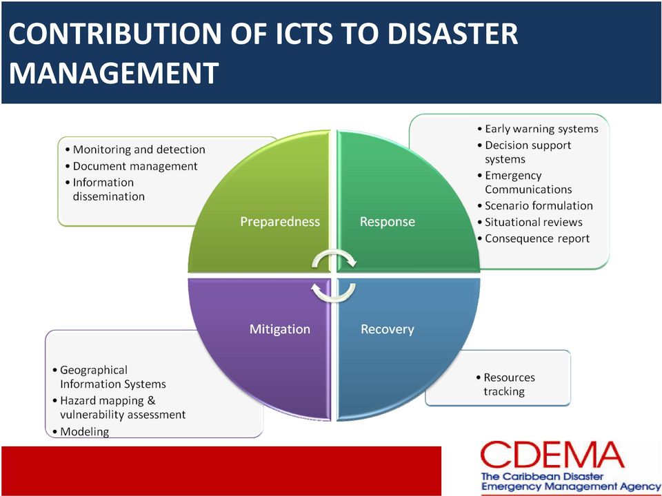
9 ADMINISTRATION SUPPORT ICTs used in the CDEMA system to support administrative and operational capabilities of the CDEMA Coordinating Unit (CU) and the National Disaster Offices (NDOs) of the PS: standard office productivity; project planning and management; human resources and administration; information storage and dissemination; fleet management; and creation and maintenance of information databases

10 GEOGRAPHICAL INFORMATION SYSTEMS GIS integrates hardware, software, and data for capturing, managing, analyzing, and displaying all forms of geographically referenced information. GIS technology contributes to resilience building in several ways: Analyzing where disasters have occurred in the past and what impacts they have had to assist in the development of more efficient methods to reduce future disaster risks. Monitoring information about the locations of key physical assets to assist in planning for their protection, as well as in determining suitable locations for new infrastructure. Determining what hazards might potentially impact a state and then determine the alternatives available to reduce the direct and indirect impacts.

11 GEOGRAPHICAL INFORMATION SYSTEMS The DEWETRA Platform The DEWETRA platform is a real-time integrated system for hydrometeorological and wildfire risk forecasting, monitoring and prevention. The system is based on the rapid availability of different data which help establish up-to-date and reliable risk scenarios. The integration of all relevant data for risk management can significantly increase the value of available information and the level of knowledge of forecasters and disaster managers. Different sources of information are ingested and managed within the platform, taking into account their diverse space-time scales and degrees of uncertainty and reliability. The DEWETRA platform uses a three-tiers software architecture: a strong middle-ware ensure robustness and computational load balancing, whereas a Web-GIS interface facilitate the information distribution.

12 EARLY WARNING SYSTEMS EWS provide the capacity to generate and disseminate timely and meaningful warning information to enable individuals, communities and organizations threatened by a hazard to prepare and to act appropriately and in sufficient time to reduce the possibility of harm or loss. Traditional electronic means are still valid in the Caribbean (television, radio, internet, telephone (fixed line and cellular) due to widespread availability. Sophisticated ICT based warning systems have been developed for hurricanes and volcanoes.
 due to")
13 EARLY WARNING SYSTEMS Technical Components of the Hurricane Early Warning System Radar When a hurricane approaches an island, it is monitored by land-based weather radar. This radar provides detailed information on hurricane wind fields and other changes to support accurate short-term warnings for especially flooding. Satellites Geostationary satellites orbiting the earth at an altitude of about km provide the National Hurricane Centre with imagery that helps provide estimates of the location, size and intensity of a tropical storm and its surrounding environment. Reconnaissance Aircraft The US Air Force provides operational reconnaissance by flying aircrafts into the core of hurricanes to measure wind, pressure, temperature and humidity as well as to provide accurate location of the centre of the hurricane. The National Oceanic and Atmospheric Administration also flies aircrafts into hurricanes to aid scientist in better understanding the dynamics of these systems and improve forecast capabilities. National Hurricane Center Models The National Hurricane Center uses several computer models to help forecast the path, speed, and strength of hurricanes. Data from weather satellites, reconnaissance aircrafts and other sources are fed into the models.

14 EARLY WARNING SYSTEMS Volcano Early Warning System in Montserrat In the spring of 2008, Montserrat completed deployment of the emergency solutions platform for alerting residents of volcanic activity. The 2wcom early warning solution uses RDS (Radio Data System) technology to trigger alerts and pass critical text and voice information to targeted groups of 2wcom receivers including homes, schools and critical agencies at risk during an eruption. In May 2008, the DMCA began testing the system by continuously alerting residents and tourists when the Soufrière Hills volcano showed signs of activity.

15 DECISION SUPPORT SYSTEMS DSS are technologies that integrate computer hardware and software designed to complement the cognitive processes of humans in their decision making. Essential components are: a data bank containing information about a particular environment; data analysis capability; normative models; and technology for the interactive use of the data and models which links the disaster manager with other components of the DSS.

16 DECISION SUPPORT SYSTEMS WebEOC Web EOC is a web-based DSS which can be used during the planning, mitigation, response and recovery phases of any emergency. It can also be used by agencies during day-to- day activities to manage routine, non-emergency related operations. WebEOC contains a set of default electronic display status boards which provide the User with the ability to generate, post, transmit and share information, real-time, among other WebEOC users. These status boards are the equivalent to large, chronological or topical paper-based boards that are typically used in EOCs. An agency can use any or all of these boards "as is", or build an unlimited number of status boards and forms tailored to local requirements.

17 SUPPLIES TRACKING Systems designed to provide assistance in sourcing and tracking relief supplies in disaster relief operations.

18 SUPPLIES TRACKING CDEMA Relief Supplies Tracking System The Relief Supply Tracking System (RSTS) is an online database designed to facilitate the management and tracking of disaster relief supplies. It supports better management and coordination of relief operations by providing a means to collect, organize and analyze disaster relief information. The RSTS was developed to provide assistance in sourcing and tracking relief supplies in disaster relief operations by capturing information on identified needs, assistance pledged, and assistance en-route or dispatched and assistance received during disaster response operations. The RSTS utilizes mainly the Inventory functionality of Sahana which is a free and open source software (FOSS) based disaster management system that grew out of the events during the 2004 Asian tsunami disaster.

19 ICT PLATFORM FOR DRM IN THE CDEMA SYSTEM In 2009, CDEMA conducted an assessment which sought to understand the state of ICT capacity and needs within the NDOs of the PS. It determined that there was significant variation in the ICT practices and capabilities of NDOs and pointed to the need to define the requirements for ICT platforms for NDOs. Subsequent to the assessment, three (3) ICT levels were developed to provide guidance to PS on ICT standards and effective utilisation. These levels were Level 1, Level 2 and Level 3; Level 1 being the minimum acceptable standard and Level 3 the highest standard. The CDEMA CU has been working with the PS to ensure that all NDOs reach and maintain at least a Level 1 ICT level.

20 CHALLENGES Some challenges remain in the widespread use of ICTs in disaster management in the Caribbean: Lack of human and financial resources to maintain the functionality of technologies provided Deficits in technical capabilities which will ensure full utilisation of ICTs Constantly changing and advancing technologies, making it difficult for SIDS to stay current A plethora of tools, sometimes with overlapping objectives, have been developed

21
Eastern Caribbean Open-Source Geospatial Data Sharing and Management Workshop
 Eastern Caribbean Open-Source Geospatial Data Sharing and Management Workshop Data Collection and Management in the Caribbean Spice Island Resort, St. George s, Grenada October 6 7, 2011 Presented by:
Caribbean Catastrophe Risk Insurance Facility (CCRIF)
") CCRIF/Swiss Re Excess Rainfall Product A Guide to Understanding the CCRIF/Swiss Re Excess Rainfall Product Published by: Caribbean Catastrophe Risk Insurance Facility (CCRIF) Contact: Caribbean Risk Managers
CCRIF/Swiss Re Excess Rainfall Product A Guide to Understanding the CCRIF/Swiss Re Excess Rainfall Product Published by: Caribbean Catastrophe Risk Insurance Facility (CCRIF) Contact: Caribbean Risk Managers
CARIBBEAN DISASTER EMERGENCY MANAGEMENT AGENCY (CDEMA)
") CARIBBEAN DISASTER EMERGENCY MANAGEMENT AGENCY (CDEMA) The Caribbean Disaster Emergency Management Agency (CDEMA) is a regional inter-governmental agency for disaster management in the Caribbean Community
CARIBBEAN DISASTER EMERGENCY MANAGEMENT AGENCY (CDEMA) The Caribbean Disaster Emergency Management Agency (CDEMA) is a regional inter-governmental agency for disaster management in the Caribbean Community
Japan-World Bank Program for Mainstreaming DRM in Developing Countries
 THE WORLD BANK TERMS OF REFERENCE JAPAN-WORLD BANK PROGRAM FOR MAINSTREAMING DISASTER RISK MANAGEMENT IN DEVELOPING COUNTRIES SMART DISASTER RISK MANAGEMENT (DRM) - ICT READINESS AND APPLICATIONS A. PROJECT
Natural Disasters & Assessing Hazards and Risk. Natural Hazards and Natural Disasters
 Page 1 of 9 EENS 3050 Tulane University Natural Disasters Prof. Stephen A. Nelson Natural Disasters & Assessing Hazards and Risk This page last updated on 19-Aug-2014 Natural Hazards and Natural Disasters
limate Change, SIDS and Insurance ick Silver NFCC Expert Meeting on Adaptation for SIDS arotonga, Cook Islands 26-28 February 2007
 limate Change, SIDS and Insurance ick Silver NFCC Expert Meeting on Adaptation for SIDS arotonga, Cook Islands 26-28 February 2007 Issues for further consideration (c) Is insurance the most suitable mechanism
CCRIF: Application of Risk Analysis and Modelling in the Insurance Sector
 CCRIF: Application of Risk Analysis and Modelling in the Insurance Sector Technical Cooperation Workshop for Development of the Caribbean Regional Cooperation Programme in Multi-Hazard Early Warning System
DEWETRA: la piattaforma nazionale per la condivisioni di dati, previsioni e procedure per le attivita di DRR
 Dipartimento della Protezione Civile Fondazione CIMA DEWETRA: la piattaforma nazionale per la condivisioni di dati, previsioni e procedure per le attivita di DRR G. Boni 2, P. Pagliara 1, A. Corina 1 1
DRAFT TSUNAMI WARNING INFORMATION DISSEMINATION PROTOCOL FOR TRINIDAD AND TOBAGO (CDEMA PARTICIPATING STATE)
") DRAFT TSUNAMI WARNING INFORMATION DISSEMINATION PROTOCOL FOR TRINIDAD AND TOBAGO (CDEMA PARTICIPATING STATE) ODPM 6/3/2011 CONTENTS 1. Acronyms 2. Standard operating procedures A: (SOP A): 3. Standard
DRAFT TSUNAMI WARNING INFORMATION DISSEMINATION PROTOCOL FOR TRINIDAD AND TOBAGO (CDEMA PARTICIPATING STATE) ODPM 6/3/2011 CONTENTS 1. Acronyms 2. Standard operating procedures A: (SOP A): 3. Standard
The Role of Insurance in Adaptation Finance in the Caribbean
 The Role of Insurance in Adaptation Finance in the Caribbean the CCRIF Experience Isaac Anthony, Chief Executive Officer Caribbean Catastrophe Risk Insurance Facility (CCRIF) Session 4 Mobilizing Private
Situation Report #2 Hurricane Irene impact on Turks and Caicos Islands and The Bahamas (as at 5:00 p.m.)
") Situation Report #2 Hurricane Irene impact on Turks and Caicos Islands and The Bahamas (as at 5:00 p.m.) Hurricane Irene impacting the Turks and Caicos Islands and Bahamas Message: Hurricane Irene a Category
Situation Report #2 Hurricane Irene impact on Turks and Caicos Islands and The Bahamas (as at 5:00 p.m.) Hurricane Irene impacting the Turks and Caicos Islands and Bahamas Message: Hurricane Irene a Category
How can we defend ourselves from the hazard of Nature in the modern society?
 How can we defend ourselves from the hazard of Nature in the modern society?, University of Bologna President of the EGU Division of Natural Hazards Email: stefano.tinti@unibo.it nh@egu.eu GIFT 2013 Natural
Head 168 HONG KONG OBSERVATORY
 Controlling officer: the Director of the Hong Kong Observatory will account for expenditure under this Head. Estimate... $203.4m Establishment ceiling (notional annual mid-point salary value) representing
HEALTH INFORMATION MANAGEMENT In Emergency
 HEALTH INFORMATION MANAGEMENT In Emergency Regional training course on emergency response operation, Hue, Viet Nam, 23-27 Feb, 2009 Learning Objectives By the end of this session, the participant should
Geosciences - Programme subject in programme for Specialization in General Studies
 Geosciences - Programme subject in programme for Specialization in General Studies Dette er en oversettelse av den fastsatte læreplanteksten. Læreplanen er fastsatt på Bokmål Laid down as a regulation
Geohazards: Minimizing Risk, Maximizing Awareness The Role of the Insurance Industry
 Geohazards: Minimizing Risk, Maximizing Awareness The Role of the Insurance Industry Prof. Dr. Peter Hoeppe Head of Geo Risks Research Munich Re International Year of Planet Earth, Paris, 13 February 2008
Why Should You Use Sahana Eden?
 Open Source Disaster Management Software Platform Why Should You Use Sahana Eden? Sahana Eden is an open source software platform which has been built specifically to help in Disaster Management. It is
Humanitarian programming, risk management including insurance, & livelihood resilience
 Humanitarian programming, risk management including insurance, & livelihood resilience Session 2: Humanitarian programming for risk reduction and resilience Dakar, Senegal 2-3 October 2013 Central idea:
The Government of Dominica has declared nine (9) Special Disaster Areas. These are:
 Special Disaster Areas. These are:") EVENT: Erika became the fifth named storm of this year s Atlantic Hurricane Season on August 24, 2015. Erika began impacting the CDEMA Participating States from Wednesday, August 26 and degenerated to
EVENT: Erika became the fifth named storm of this year s Atlantic Hurricane Season on August 24, 2015. Erika began impacting the CDEMA Participating States from Wednesday, August 26 and degenerated to
Southwest Indian Ocean. Risk Assessment and Financing Initiative (SWIO RAFI) GFDRR GFDRR. Global Facility for Disaster Reduction and Recovery
 GFDRR GFDRR. Global Facility for Disaster Reduction and Recovery") Southwest Indian Ocean Risk Assessment and Financing Initiative (SWIO RAFI) GFDRR GFDRR Global Facility for Disaster Reduction and Recovery Global Facility for Disaster Reduction and Recovery THE PURPOSE
Southwest Indian Ocean Risk Assessment and Financing Initiative (SWIO RAFI) GFDRR GFDRR Global Facility for Disaster Reduction and Recovery Global Facility for Disaster Reduction and Recovery THE PURPOSE
Hazard Detection, Monitoring, Modeling, Assessment and Warning in the Asia Pacific Region
 Chengdu Forum on UN-GGIM Global Map for Sustainable Development: Development and Applications in Urban Hazard Mapping Chengdu, Sichuan Province, China 15-17 Oct 2013 Hazard Detection, Monitoring, Modeling,
Committee on the Peaceful Uses of Outer Space Fifty-eighth session
 10 June 2015 English only Committee on the Peaceful Uses of Outer Space Fifty-eighth session Vienna, 10-19 June 2015 The United Nations/Germany International Conference on Earth Observation Global Solutions
The Caribbean Disaster Mitigation Project: Supporting Sustainable Responses to Natural Hazards
 The Caribbean Disaster Mitigation Project: Supporting Sustainable Responses to Natural Hazards Steven Stichter Caribbean Disaster Mitigation Project (CDMP) Unit of Sustainable Development and Environment
Ernst Rauch Munich Re 18 October 2011
 INSURANCE OF NATURAL CATASTROPHES: DATA REQUIREMENTS, RISK ANALYSIS, INDEMNIFICATION Conference Prevention and Insurance of Natural Catastrophes - 18 October 2011, Brussels Ernst Rauch Head Corporate Climate
Emergency Management Service. early warning FLOOD AND FIRE ALERTS. Space
 Emergency Management Service early warning FLOOD AND FIRE ALERTS Space 1 Copernicus at a Glance Copernicus is the European Union s Earth Observation programme: a user-driven space programme under civil
Climate Change Long Term Trends and their Implications for Emergency Management August 2011
 Climate Change Long Term Trends and their Implications for Emergency Management August 2011 Overview A significant amount of existing research indicates that the world s climate is changing. Emergency
Emergency Management is responsible for coordinating the City of Houston s preparation for and response to emergency situations.
 CITY OF HOUSTON Office of Emergency Management October 2004 Emergency Management is responsible for coordinating the City of Houston s preparation for and response to emergency situations. Houston is exposed
An Update on the Work of the Florida Catastrophic Storm Risk Management Center. Lorilee A. Medders, Ph.D. Director
 An Update on the Work of the Florida Catastrophic Storm Risk Management Center Lorilee A. Medders, Ph.D. Director Florida Hurricane Catastrophe Fund Workshop June 11, 2015 Buena Vista, Florida Section
End to End Multi Hazard Early Warning Systems By Curt Barrett Hydrometeorological Consultant
 End to End Multi Hazard Early Warning Systems By Curt Barrett Hydrometeorological Consultant Disaster Risk Management- East Asia and Pacific Experts Roundtable on Urban Flood Risk Management March 17,
Glossary. ambulance: a vehicle equipped for transportation of sick and injured persons. believe: to accept as true or real
 act: the process of doing or performing something ambulance: a vehicle equipped for transportation of sick and injured persons believe: to accept as true or real cascading disaster: the effects of one
JRC and GMES GIO-EMS
 Joint Research Centre JRC and GMES GIO-EMS Guido Lemoine, Jan Kucera, Marco Broglia JRC, Ispra 1st GMES NATIONAL USER FORUM DAY Prague, 29-30 May 2012 Serving society Stimulating innovation Supporting
2015 Global Risk Assessment. Sahar Safaie Program Officer, UNISDR Risk Knowledge Section
 2015 Global Risk Assessment Sahar Safaie Program Officer, UNISDR Risk Knowledge Section Outline Global Assessment Report (GAR) evolution Global Risk Assessment for GAR15 Objective Scope Audience/Users
sample The IPCC Special Report on Managing the Risks of Extreme Events and Disasters to Advance Climate Change Adaptation
 sample The IPCC Special Report on Managing the Risks of Extreme Events and Disasters to Advance Climate Change Adaptation A changing climate leads to changes in extreme weather and climate events 2 Impacts
 1 2 A very short description of the functional center network: regarding the Hydraulic and Hydrogeological risk, the national alert system is ensured by the National Civil Protection Department (DPCN),
Design and Deployment of Specialized Visualizations for Weather-Sensitive Electric Distribution Operations
 Fourth Symposium on Policy and Socio-Economic Research 4.1 Design and Deployment of Specialized Visualizations for Weather-Sensitive Electric Distribution Operations Lloyd A. Treinish IBM, Yorktown Heights,
Disaster Risk Reduction through people centered National Multi-hazard Early Warning System in the context of Maldives
 Disaster Risk Reduction through people centered National Multi-hazard Early Warning System in the context of Maldives Abdul Muhusin, Deputy Director Department of Meteorology, Maldives Fourth Technical
Socio-economic Impacts of Natural Disasters in the Caribbean
 ECONOMIC COMMISSION FOR LATIN AMERICA AND THE CARIBBEAN Subregional Headquarters for the Caribbean Socio-economic Impacts of Natural Disasters in the Caribbean The ECLAC Mission "Our mission is to deepen
Public-Private Sector Partnerships in Disaster Reduction Private sector companies are major contributors in response to disasters worldwide
 Public-Private Partnerships in Disaster Risk Reduction Challenges and Solutions Brent Woodworth Worldwide Segment Manager, Public-Private Sector Partnerships in Disaster Reduction Private sector companies
INSTALLATION OF AN AUTOMATED EARLY WARNING SYSTEM FOR ANNOTTO BAY
 TERMS OF REFERENCE INSTALLATION OF AN AUTOMATED EARLY WARNING SYSTEM FOR ANNOTTO BAY A Community Disaster Risk Reduction Project funded through the Building Disaster Resilient Communities Project (ODPEM)
Geospatial Software Solutions for the Environment and Natural Resources
 Geospatial Software Solutions for the Environment and Natural Resources Manage and Preserve the Environment and its Natural Resources Our environment and the natural resources it provides play a growing
Communications Systems Used in the USA TARNS. Chris Hill, Meteorologist in Charge (ret) National Weather Service Seattle, Washington, USA
 National Weather Service Seattle, Washington, USA") Communications Systems Used in the USA TARNS Chris Hill, Meteorologist in Charge (ret) National Weather Service Seattle, Washington, USA Washington Faces Many Non-Weather Hazards Earthquakes Tsunamis Terrorism
Communications Systems Used in the USA TARNS Chris Hill, Meteorologist in Charge (ret) National Weather Service Seattle, Washington, USA Washington Faces Many Non-Weather Hazards Earthquakes Tsunamis Terrorism
BUSINESS CONTINUITY PLAN OVERVIEW
 BUSINESS CONTINUITY PLAN OVERVIEW INTRODUCTION The purpose of this document is to provide Loomis customers with an overview of the company s Business Continuity Plan (BCP). Because of the specific and
It also provides guidance for rapid alerting and warning to key officials and the general public of a potential or occurring emergency or disaster.
 Emergency Support Function #2 Communications ESF Coordinator: Information Technology Department Support Agencies: Tucson Fire Department Parks and Recreation Department Tucson Police Department Tucson
Disaster Risk Assessment:
 Disaster Risk Assessment: Disaster Risk Modeling Dr. Jianping Yan Disaster Risk Assessment Specialist Session Outline Overview of Risk Modeling For insurance For public policy Conceptual Model Modeling
Africa Adaptation Programme
 Africa Adaptation Programme Examples of experiences, challenges and success stories from implemented and ongoing projects and initiatives on climate observations Joseph D. Intsiful AAP Data and information
How To Help The Most Vulnerable
 Remarks by Mr. Gyan Chandra Acharya Under-Secretary-General High Representative for the Least Developed Countries, Landlocked Developing Countries and Small Island Developing States at Plenary of the Third
Malawi & Zambia - Working with the Swiss Agency for Development and Cooperation and Government of Malawi - covering around 20k farmers
 Focus areas of risk management for loss and damage associated with climate change impacts agriculture, rural development, livelihood risk management Geographic coverage Africa, caribbean, Asia Key stakeholders
Trends of Natural Disasters the Role of Global Warming
 Trends of Natural Disasters the Role of Global Warming Prof. Dr. Peter Hoeppe Geo Risks Research Munich Reinsurance Company Geo Risks Research Department of Munich Re - Analyses of natural disasters since
NOTICE: This publication is available at: http://www.nws.noaa.gov/directives/.
 Department of Commerce National Oceanic & Atmospheric Administration National Weather Service NATIONAL WEATHER SERVICE INSTRUCTION 10-1604 July 29, 2011 Operations and Services Performance, NWSPD 10-16
Analysis of Alert Messages formats for Environmental Disaster Management
 43 Analysis of Alert Messages formats for Environmental Disaster Management Raffaela Cefalo, Simone Maver, Claudia Paparini GeoSNAV Laboratory Department of Civil Engineering and Architecture University
Weather Risk Mitigation for Insurance Carriers
 Weather Risk Mitigation for Insurance Carriers Weather Targeting Solutions Copyright 2015 Skymosity Weather Risk Mitigation for Insurance Carriers - Weather Targeting Solutions Page 1 Table of Contents
From Whitehall to orbit and back again: using space in government
 From Whitehall to orbit and back again: using space in government 18 th June 2014 Bristol 25 th June 2014 Liverpool 3 rd July 2014 -Newcastle Space for Smarter Government Programme (ssgp@sa.catapult.org.uk)
The IPCC Special Report on Managing the Risks of Extreme Events and Disasters to Advance Climate Change Adaptation
 The IPCC Special Report on Managing the Risks of Extreme Events and Disasters to Advance Climate Change Adaptation A changing climate leads to changes in extreme weather and climate events 2 How do changes
Graduate School of Disaster Prevention Kangwon National University. http://college.kangwon.ac.kr/prevention/main.jsp
 Graduate School of Disaster Prevention Kangwon National University 1joongang-Ro Samcheok-city, Gangwon-Do, Republic of Korea http://college.kangwon.ac.kr/prevention/main.jsp Outline Natural disasters such
Disaster Risk Reduction and Building Resilience to Climate Change Impacts
 Disaster Risk Reduction and Building Resilience to Climate Change Impacts Luna Abu-Swaireh (abu-swaireh@un.org) May 2015 United Nations Office for Disaster Risk Reduction (UNISDR) Droughts Floods Storms
2014 Polk County ESF #2 Communications. Public Version. Public Version-Polk County ESF #2 Communications 2014
 2014 Polk County ESF #2 Communications Public Version ESF#2 Communications 2014 Polk County Emergency Management Agency Page 1 of 13 Table of Contents 1. Introduction... 3 1.1 Purpose of ESF #2: Communication...
How To Develop An Early Warning System
 149 SECTION AREA Saving lives through early warning systems and emergency preparedness Maryam Golnaraghi Ph.D, chief; James Douris, technical officer and Jean-Baptiste Migraine, junior professional officer,
Natural Hazard Risk Assessment in the Australasian Region: Informing Disaster Risk Reduction and Building Community Resilience.
 Natural Hazard Risk Assessment in the Australasian Region: Informing Disaster Risk Reduction and Building Community Resilience Jane Sexton Australia and Disaster Risk Reduction Australian Context Understanding
What is spectrum reallocation, and what does it have to do with weather satellites?
 FAQ ========= SPECTRUM REALLOCATION ========= What is spectrum reallocation, and what does it have to do with weather satellites? Because of increasing demand for wireless smartphones, tablets, and Wi-Fi
TERMS OF REFERENCE CONSULTANCY TO DEVELOP A MODEL NATIONAL RECOVERY FRAMEWORK
 TERMS OF REFERENCE CONSULTANCY TO DEVELOP A MODEL NATIONAL RECOVERY FRAMEWORK 1.0 INTRODUCTION The Caribbean is one of the most disaster prone regions in the world 1. Economic, social and environmental
THE DEPARTMENT OF EMERGENCY MANAGEMENT
 THE DEPARTMENT OF EMERGENCY MANAGEMENT Revised 2014 POLICY FRAMEWORK & STANDARD OPERATING PROCEDURES FOR THE SYSTEMATIC NATIONAL SHUTDOWN & REACTIVATION OF BARBADOS Foreword The Policy Framework and Standard
New Zealand Society for Earthquake Engineering. Saturday 11 April 2015 Rotorua
 New Zealand Society for Earthquake Engineering Saturday 11 April 2015 Rotorua Annual Likelihood National Severe weather Hazard Risks 10 % Once a decade 1 % Once a century Large rural flood Major transport
APPENDIX G FLOOD WARNING RESPONSE PLAN
 ESCAMBIA COUNTY, FLORIDA DEPARTMENT OF PUBLIC SAFETY POLICY/PROCEDURE-Division of Emergency Management RE: Flood Warning Response Plan Approved by: Effective Date: August 27, 2007 Revised/Reviewed Date:
CRS 610 Ventura County Flood Warning System Website
 CRS 610 Ventura County Flood Warning System Website Purpose This document gives instructions and a description of the information available via the Ventura County Watershed Protection District s (VCWPD)
GPS Use in U.S. Critical Infrastructure. and Emergency Communications. Presented to the
 GPS Use in U.S. Critical Infrastructure and Emergency Communications Presented to the DOT, DoD, and DHS United States Technical Training Institute (USTTI) Presenter Monty Graham Program Manager GPS Jamming
By: Tracy Hall. Community Bank Auditors Group Taking Your Business Continuity Plan To The Next Level. June 9, 2015
 Community Bank Auditors Group Taking Your Business Continuity Plan To The Next Level June 9, 2015 By: Tracy Hall MEMBER OF PKF NORTH AMERICA, AN ASSOCIATION OF LEGALLY INDEPENDENT FIRMS 2015 Wolf & Company,
ENVIRONMENTAL MONITORING Vol. I - Remote Sensing (Satellite) System Technologies - Michael A. Okoye and Greg T. Koeln
 System Technologies - Michael A. Okoye and Greg T. Koeln") REMOTE SENSING (SATELLITE) SYSTEM TECHNOLOGIES Michael A. Okoye and Greg T. Earth Satellite Corporation, Rockville Maryland, USA Keywords: active microwave, advantages of satellite remote sensing, atmospheric
REMOTE SENSING (SATELLITE) SYSTEM TECHNOLOGIES Michael A. Okoye and Greg T. Earth Satellite Corporation, Rockville Maryland, USA Keywords: active microwave, advantages of satellite remote sensing, atmospheric
Building Caribbean GeoNode Platform in Support of Climate Risk Management Jacob Opadeyi, PhD
 Building Caribbean GeoNode Platform in Support of Climate Risk Management Jacob Opadeyi, PhD Our Highly Vulnerable Region Housing developments on drainage channels and steep slopes Unapproved development
The Use of Geographic Information Systems in Risk Assessment
 The Use of Geographic Information Systems in Risk Assessment With Specific Focus on the RiVAMP Methodology Presented by Nadine Brown August 27, 2012 Climate Studies Group Mona Climate Change Workshop Presentation
Joint Polar Satellite System (JPSS)
") Joint Polar Satellite System (JPSS) John Furgerson, User Liaison Joint Polar Satellite System National Environmental Satellite, Data, and Information Service National Oceanic and Atmospheric Administration
Joint Polar Satellite System (JPSS) John Furgerson, User Liaison Joint Polar Satellite System National Environmental Satellite, Data, and Information Service National Oceanic and Atmospheric Administration
Public Safety Messaging System: Telecommunications Emergency Alerting Capabilities
 99 Airport Road PO Box 669 Concord, NH 03302 USA Toll Free 888-CLASSCO Fax +1 435 228-2990 www.classco.com System: Telecommunications Emergency Alerting Capabilities Summary: This paper describes an emergency
Natural Hazards 1.1. Natural Hazards. Objective: Natural Hazards in Western Australia Are we at risk? Page 1. Natural Hazards Years 5-7
 Natural Hazards 1.1 Engage Natural Hazards To introduce students to the natural hazards which occur in Western Australia and their risk. Western Australia experiences a range of natural hazards each year,
Natural Disaster Impact on Business and Communities in Taiwan. Dr. Chung-Sheng Lee. NCDR Chinese Taipei
 Natural Disaster Impact on Business and Communities in Taiwan Dr. Chung-Sheng Lee NCDR Chinese Taipei 1 Brief Introduction of NCDR 2 Organizational Chart of NCDR NDPPC: National Disaster Preparation and
Integrated Risk Management System Components in the GEO Architecture Implementation Pilot Phase 2 (AIP-2)
") Meraka Institute ICT for Earth Observation PO Box 395 Pretoria 0001, Gauteng, South Africa Telephone: +27 12 841 3028 Facsimile: +27 12 841 4720 University of KwaZulu- Natal School of Computer Science
Meraka Institute ICT for Earth Observation PO Box 395 Pretoria 0001, Gauteng, South Africa Telephone: +27 12 841 3028 Facsimile: +27 12 841 4720 University of KwaZulu- Natal School of Computer Science
HAITI: Re-Establishment of Warning Services After the January 2010 Earthquake
 HAITI: Re-Establishment of Warning Services After the January 2010 Earthquake Aftermath of the January 2010 earthquake in Haiti. Photo by World Food Programme This case study: - Corresponds well to the
A CCRIF Review of Regional Data Management and Sharing Issues
 A CCRIF Review of Regional Data Management and Sharing Issues Grahame Niles Caribbean Catastrophe Risk Insurance Facility (CCRIF) Presenta:on Format What is CCRIF? How CCRIF Uses Data The Impact of Regional
TOPIC 4 Disaster Risks, Mitigation, Warning Systems & Socio-Economic Impacts. Jim Davidson
 TOPIC 4 Disaster Risks, Mitigation, Warning Systems & Socio-Economic Impacts Jim Davidson Richard Murnane Bill Read Lixion Avila - ST Chan Linda Anderson-Berry David King - Ryan Crompton IWTC-VII November
Japan Meteorological Business Support Center (JMBSC)
") Japan Meteorological Business Support Center (JMBSC) The Japan Meteorological Business Support Center (JMBSC) is a general incorporated foundation* inaugurated in 1994, in accordance with the Meteorological
Japan Meteorological Business Support Center (JMBSC) The Japan Meteorological Business Support Center (JMBSC) is a general incorporated foundation* inaugurated in 1994, in accordance with the Meteorological
Pacific Catastrophe Risk Assessment and Financing Initiative. Better Information for Smarter Investments
 Pacific Catastrophe Risk Assessment and Financing Initiative Better Information for Smarter Investments Main Outputs Pacific disaster risk assessment Probabilistic assessment of major perils Pacific Risk
Table of Contents ESF-12-1 034-00-13
 Table of Contents Primary Coordinating Agency... 2 Local Supporting Agencies... 2 State, Regional, and Federal Agencies and Organizations... 2 Purpose... 3 Situations and Assumptions... 4 Direction and
International Network for Multi-Hazard Early Warning Systems (IN-MHEWS)
") International Network for Multi-Hazard Early Warning Systems (IN-MHEWS) A Multi-Stakeholder Partnership for Promoting and Sharing Best Practice in Multi-Hazard Early Warning Systems and Services for Disaster
International Network for Multi-Hazard Early Warning Systems (IN-MHEWS) A Multi-Stakeholder Partnership for Promoting and Sharing Best Practice in Multi-Hazard Early Warning Systems and Services for Disaster
EFAS European Flood Awareness System
 EFAS European Flood Awareness System http://www.efas.eu/ EFAS Partner Network The first operational hydrological network in Europe Cristina Alionte Eklund Coordinator EFAS Dissemination Center History
Multi-Hazard Disaster Risk Assessment (v2)
") Multi-Hazard Disaster Risk Assessment (v2) This How to Note is part of a series of Guidance Notes designed to assist DFID Country Offices in embedding disaster resilience in their country programmes. This
Multi-Hazard Disaster Risk Assessment (v2) This How to Note is part of a series of Guidance Notes designed to assist DFID Country Offices in embedding disaster resilience in their country programmes. This
Draft 8/1/05 SYSTEM First Rev. 8/9/05 2 nd Rev. 8/30/05 EMERGENCY OPERATIONS PLAN
 Draft 8/1/05 SYSTEM First Rev. 8/9/05 2 nd Rev. 8/30/05 EMERGENCY OPERATIONS PLAN I. INTRODUCTION A. PURPOSE - The University of Hawaii System Emergency Operations Plan (EOP) provides procedures for managing
Optimizing the Mobile Claims Process through Location Analytics. An Esri White Paper April 2014
 Optimizing the Mobile Claims Process An Esri White Paper April 2014 Copyright 2014 Esri All rights reserved. Printed in the United States of America. The information contained in this document is the exclusive
The Earth System. The geosphere is the solid Earth that includes the continental and oceanic crust as well as the various layers of Earth s interior.
 The Earth System The atmosphere is the gaseous envelope that surrounds Earth. It consists of a mixture of gases composed primarily of nitrogen, oxygen, carbon dioxide, and water vapor. The atmosphere and
ROAD WEATHER AND WINTER MAINTENANCE
 Road Traffic Technology ROAD WEATHER AND WINTER MAINTENANCE METIS SSWM WMi ROAD WEATHER STATIONS ADVANCED ROAD WEATHER INFORMATION SYSTEM MAINTENANCE DECISION SUPPORT SYSTEM WINTER MAINTENANCE PERFORMANCE
Disaster Risk Reduction UNESCO s contribution to a global challenge
 United Nations International Geoscience Programme Disaster Risk Reduction UNESCO s contribution to a global challenge UNESCO and Disaster Risk Reduction UNESCO operates at the interface between natural
Town of Warwick, Village of Florida, Village of Greenwood Lake and Village of Warwick MULTI JURISIDICTIONAL, MULTI HAZARD MITIGATION PLAN DRAFT
 Town of Warwick, Village of Florida, Village of Greenwood Lake and Village of Warwick MULTI JURISIDICTIONAL, MULTI HAZARD MITIGATION PLAN DRAFT Appendix B Historical Hazard Documentation Rev #0 May 2013
Wildfires pose an on-going. Integrating LiDAR with Wildfire Risk Analysis for Electric Utilities. By Jason Amadori & David Buckley
 Figure 1. Vegetation Encroachments Highlighted in Blue and Orange in Classified LiDAR Point Cloud Integrating LiDAR with Wildfire Risk Analysis for Electric Utilities Wildfires pose an on-going hazard
Creating a More Resilient Future. Friday 30 May, 11:00 to 12:30, Rooms S29-31
 Creating a More Resilient Future Friday 30 May, 11:00 to 12:30, Rooms S29-31 Empowering Resilience With GIS ICLEI Smart Resilient Cities Strategic Use of Spatial Systems Jim Geringer, Esri Former Governor,
Precipitation Monitoring Network:
 The Caribbean Drought and Precipitation Monitoring Network: Adrian R. Trotman Caribbean Institute for Meteorology and Hydrology CARIWIN Regional Seminar 14-15 January, 2010 Georgetown, Guyana Why Plan
PACIFIC CATASTROPHE RISK ASSESSMENT AND FINANCING INITIATIVE
 PACIFIC CATASTROPHE RISK ASSESSMENT AND FINANCING INITIATIVE NIUE SEPTEMBER 11 COUNTRY RISK PROFILE: NIUE Niue is expected to incur, on average,.9 million USD per year in losses due to earthquakes and
Response, Recovery, and Resilience
 Response, Recovery, and Resilience KATHLEEN TIERNEY ATURAL HAZARDS CENTER NIVERSITY OF COLORADO RESILIENCE THE ABILITYOF PHYSICAL SYSTEMS AND SOCIAL UNITS TO: Mitigate Hazards Contain the Effects of Disasters
HAZARD VULNERABILITY & RISK ASSESSMENT
 Hazard Vulnerability Analysis Purpose and Scope A Hazard Vulnerability Analysis (HVA) evaluates risk associated with a specific hazard. During this analysis, the hazard is evaluated for its probability
DISASTER RECOVERY AND NETWORK REDUNDANCY WHITE PAPER
 DISASTER RECOVERY AND NETWORK REDUNDANCY WHITE PAPER Disasters or accidents would cause great harm on network infrastructure. It is unavoidable and the operation of network would be hampered for a long
Real Time Flood Alert System (RTFAS) for Puerto Rico
 for Puerto Rico") Prepared in cooperation with the Puerto Rico Emergency Management Agency (PREMA) Real Time Flood Alert System (RTFAS) for Puerto Rico Overview The Real Time Flood Alert System is a web-based computer program,
Prepared in cooperation with the Puerto Rico Emergency Management Agency (PREMA) Real Time Flood Alert System (RTFAS) for Puerto Rico Overview The Real Time Flood Alert System is a web-based computer program,
Hotel Resilient. With support from the German Government through
 Hotel Resilient With support from the German Government through Objective: Improve disaster risk management and strengthen resilience in hotels/resorts and throughout tourism destinations Hotel Resilient
Disasters and Communication Technology: Perspectives from Asia
 Disasters and Communication Technology: Perspectives from Asia Dr. Suvit Yodmani * David Hollister Presented at the Second Tampere Conference on Disaster Communications, 28-30 May 2001. I. Introduction
Flash Flood Guidance Systems
 Flash Flood Guidance Systems Introduction The Flash Flood Guidance System (FFGS) was designed and developed by the Hydrologic Research Center a non-profit public benefit corporation located in of San Diego,