Early Warning System in Japan and Lessons learnt from recent TC Disasters
|
|
|
- Todd O’Neal’
- 10 years ago
- Views:
Transcription
1 JMA/WMO Workshop on Effective Tropical Cyclone Warning in Southeast Asia Tokyo, JAPAN, March 2014 Early Warning System in Japan and Lessons learnt from recent TC Disasters 14 March 2014 Yosuke IGARASHI Japan Meteorological Agency 1

2 Observations Space Based Observation JMA's Operational Service Analysis and Forecast Computer System for Met. Service Products Warnings, Advisories Upper Air Observation Numerical Weather Prediction Radar Observation Surface Observation Ocean Observation Data Collection Collection and Dissemination of Met. Data Local Met. Observatories Information Issuance Typhoon Forecast Weather Forecast One Week Forecast International Data Exchange Data/Products Seasonal Forecast Aeronautical Met. Information Other NMHSs Marine Met. Information 2

3 Dissemination of Warnings JMA disseminates warnings and information via various channels in order to reach people surely and quickly. Japan Meteorological Agency (Local Meteorological Observatories) Issuance of disaster prevention information, such as: -Weather Warning / -Typhoon Info. -Earthquake Early Warning / Info. -Tsunami Warning / / Info. -Volcanic Warning / Info. -Aviation / Marine Weather Info. -Volcanic Ash Japan Meteorological Business Support Center Prefectural Governments National Police Agency Fire and Disaster Management Agency NTT (Nippon Telegraph and Telephone Corporation) MLIT (Water and Disaster Management Bureau) JMA Website, etc. Cellular carrier NHK (Japan Broadcasting Corporation) Media Organizations Public Weather Services Japan Coast Guard Municipality Governments Public Agencies etc. Disaster Prevention Activities The Public Service Users Marine Vessels MLIT (Civil Aviation Bureau) Airplanes 3
 MLIT")
4 Recent Heavy Rain, Flood and Storms in Japan (Number of dead or missing) Damages caused by heavy rain, flood and storms Source: "Shobo Hakusho 2013" (white paper on fire and disaster management) Dead or missing Houses destroyed completely or partially (Number of houses) (Year) 2004: 10 typhoons struck Japan! 2011: Heavy rain caused by typhoon Talas 4
 2004: 10 typhoons struck Japan!")
5 10 Typhoons struck Japan from June to October km T0404 (landed on Japan around 16:00JST, Jun 11) T0406 (landed on Japan around 09:30JST, Jun 21) T0410 (landed on Japan around 16:00JST, Jul 31) T0411 (landed on Japan around 22:30JST, Aug 4) T0415 (landed on Japan around 06:00JST, Aug 20) T0416 (landed on Japan around 10:00JST, Aug 30) T0418 (landed on Japan around 09:30JST, Sep 7) T0421 (landed on Japan around 08:30JST, Sep 29) T0422 (landed on Japan around 16:00JST, Oct 9) T0423 (landed on Japan around 13:00JST, Oct 20) 5
 T0422 (landed on Japan around 16:00JST, Oct 9) T0423 (landed on Japan around")
6 Guidelines for Producing a Decision and Dissemination Manual for Advisories and Orders (Cabinet Office, 2005) During the disasters in 2004, mayors did not issue the evacuation advisory / order for appropriate hazardous areas in a timely manner. Background: Mayors can not make decision because they have not pre-determined specific criteria for evacuation advisory / order. Not determined: 15.6% Specific criteria is pre-determined: 7.1% Criteria is pre-determined: 84.4% Not determined: 92.9% Source: Cabinet Office, 2004 Municipalities should determine specific criteria. 6

7 Improvement of Warning JMA Warning Municipalities Order Warning Residents Warning In order that JMA's warnings help mayors' decision Warnings should be issued to city / town / village respectively. 2. Warning criteria should be consistent with the criteria for evacuation advisory and order. 7

8 Warning for Cities, Towns and Villages Warnings used to be issued by zones that include several cities, towns and villages together in the same group (375 zones in Japan). 23区 東部 多摩西部 多摩北部 23 区西部 多摩南部 warning advisory no warning / advisory 20km Tokyo JMA divided warning zones into city, town and village basis in 2008 (more than 1,700 zones in Japan). 奥多摩町 足立区 葛飾区 練馬区 西東京市 渋谷区 府中市 狛江市 多摩市 稲城市 世田谷区 目黒区 調布市 台東区 千代田区 中央区 杉並区 三鷹市 文京区 新宿区 港区 国立市 日野市 武蔵野市 江東区 江戸川区 小平市 国分寺市 小金井市 墨田区 荒川区 豊島区 立川市 昭島市 八王子市 東村山市 中野区 あきる野市 福生市 檜原村 武蔵 村山市 東大和市 羽村市 板橋区 清瀬市 瑞穂町 北区 青梅市 品川区 町田市 大田区 8
.")
9 Improvement of the Criteria for Flood Forecast Criteria recommended in the Guideline Mayor's Decision Criteria Flood Forecast with Level Water Level Setting Order Preparation Information Water level of the river has reached "Flood Danger Level." Embankment is broken. Water level of the river is expected to reach "Flood Danger Level" in certain hours*. *: Necessary time for people to evacuate Water level of the river is expected to reach "Flood Danger Level" in certain hours*. *: Necessary time for people who require assistance to evacuate Flood Danger Level Flood Alert Level Flood Watch Level Standby Level Flood Forecast Title Water Level Lv5: Flood Occurrence Info. (Flood occur) Lv4: Flood Danger Info. Flood Danger Level Lv3: Flood Alerting Info. Flood Alert Level Lv2: Flood Info. Flood Watch Level - Standby Level 9

10 Improvement of the Criteria for Storm Surge Warning Criteria recommended in the Guideline Mayor's Decision Criteria JMA set the criteria for storm surge warning consistent with "Storm Surge Danger Level." Order Preparation Information Sea level has reached "Storm Surge Danger Level." Tidal embankment is broken. Sea level is expected to reach "Storm Surge Danger Level" in certain hours*. *: Necessary time for people to evacuate, however, storm will be also expected as the tyhoon approaching, mayors should consider the advisory when it meets the criteria for preparation information. Sea level is expected to reach "Storm Surge Danger Level" in certain hours*. *: Necessary time for people who require assistance to evacuate 1. If the municipality already set the "Storm Surge Danger Level", JMA set the level as the warning criterion for the city, town or village. 2. If the municipality is NOT set the "Storm Surge Danger Level", JMA set the warning criterion based on the survey (e.g. design high tide level for embankment, lowest altitude of the wharf). 10

11 Improvement of the Criteria for Sediment Disaster Alert Criteria recommended in the Guideline Mayor's Decision Criteria JMA set the "Critical Line" as the criteria for Sediment Disaster Alert. Order Preparation Information The rainfall situation has reached "Critical Line." A sediment disaster has occurred in neighbours. The rainfall situation is expected to reach "Critical Line" in certain hours*. *: Necessary time for people to evacuate The rainfall situation is expected to reach "Critical Line" in certain hours*. *: Necessary time for people who require assistance to evacuate 60 min. rainfall amount (mm) 60 分 間 積 算 雨 量 (mm/hr) Unreal Area rainfall with NO sediment 非 発 disaster 生 降 雨 rainfall with sediment disaster probability 降 of 雨 rainfall 発 現 occurrence 確 率 値 Soil Water Index (mm) 土 壌 雨 量 指 数 (mm) Critical Line of Sediment Disaster Occurrence 0 11

12 Situation on Pre-setting Specific Criteria in 2012 Flood Storm Surge Sediment Disaster Specific criteria has been pre-determined Specific criteria are under reviewing Specific criteria are under development Not yet started Source: Fire and Disaster Management Agency,

13 Achievement of the Link between Warnings and Mayors Decision Mayors Decision Disaster Sediment Disaster River Flooding Storm Surge Flooding Preparation Information Sediment Disaster Alert Heavy Rain Warning Flood Warning Flood Alerting Information Flood Information Storm Surge Warning Setting Up Disaster Countermeasures Heavy Rain Flood Storm Surge 13

14 Typhoon Talas Brought a Long-term Heavy Rainfall in 2011 Cumulative rainfall amount from 2 to 4 September, (mm) 50km 14

15 Heavy Rain by Talas caused Catastrophic Damage Damages: 98 dead or missing 3,538 houses comp / part destroyed 22,094 houses flooded Source: Fire and Disaster Management Agency, 2012 Talas visible image and its track (red line) at 12JST of Sep. 2. Source: Ministry of Land, Infrastructure, Transport and Tourism, 2011 (figure) 15

16 Warnings during the Heavy Rain by Talas Rainfall continued after JMA had issued warning, and the situation became worse and worse. However, there was no effective way to inform the public of the catastrophic situation we never experienced! 1 hour rainfall amount (mm) Kazeya Heavy Rain 1 hour rainfall amount Cumulative rainfall amount 9 月 の 月 降 水 量 の 平 年 値 282.7mm 282.7mm: mean one-month rainfall amount in September Sediment Disaster Alert Heavy Rain Warning Sediment Disaster Cumulative rainfall amount (mm) 0:00 12:00 0:00 12:00 0:00 12:00 0:00 12:00 0:00 12:00 Aug. 31 Sep. 1 Sep. 2 Sep. 3 Sep. 4 Observed Rainfall Amount at Kazeya in Totsukawa village, Nara prefecture 16
 0:00 12:00 0:00 12:00 0:00")
17 Establishment of "Emergency Warning" Intensity level (Precipitation etc.) Once in 50 years level Serious disasters will most probably happen Emergency Warning Warning level Serious disasters may happen Warning level Disasters may happen Disaster Serious Disaster Serious Disasters (Higher possibility) Time Emergency Warning is issued when JMA expects the precipitation amount of statistically estimated once in 50 years. 17
 Time Emergency Warning is issued when JMA expects the precipitation amount")
18 Expected Timing of Issuance of Emgency Warning Heavy Rain Emg Warning 1 hour rainfall amount (mm) Kazeya Heavy Rain 1 hour rainfall amount Cumulative rainfall amount 9 月 の 月 降 水 量 の 平 年 値 282.7mm 282.7mm: mean one-month rainfall amount in September Sediment Disaster Alert Heavy Rain Warning Sediment Disaster Cumulative rainfall amount (mm) 0:00 12:00 0:00 12:00 0:00 12:00 0:00 12:00 0:00 12:00 Aug. 31 Sep. 1 Sep. 2 Sep. 3 Sep. 4 Observed Rainfall Amount at Kazeya in Totsukawa village, Nara prefecture 18
 0:00 12:00 0:00 12:00 0:00 12:00 0:00 12:00 0:00 12:00 Aug. 31 Sep. 1 Sep. 2 Sep. 3 Sep.")
19 Emgency Warning during the Typhoon Man-yi in km Emgency Warning Warning No Warning / Otsu, Shiga prefecture 50 Emg. Warning 05:05, 16 Sep 1 hour rainfall amount (mm) 時 hour 間 降 rainfall 水 量 (ミリ) (mm) Cumulative 積 算 降 水 量 rainfall (ミリ) (mm) 13:54, 15 Sep Warning 18:48, 15 Sep Cumulative rainfall amount (mm) Press briefing 0 0 時 3 時 6 時 9 時 12 時 15 時 18 時 21 時 24 時 3 時 6 時 9 時 12 時 0 19
 (mm) 13:54, 15 Sep Warning 18:48, 15 Sep 300 200 100 Cumulative")
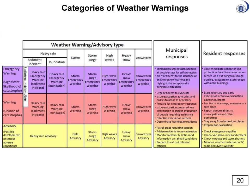
20 Categories of Weather Warnings 20
21 Summary of History on our Improvement 2 grades information --- advisory, warning 2004: 10 typhoons hit Japan Lesson: Warnings need to connect to action After 2004: Restructuring of warning warning zones be set as city, town and village areas warning criteria be consistent with the criteria of evacuation order 2011: Unprecedented rainfall by typhoon Talas Lesson: Effective message in emergency situation. 2013: Emergency warning launched Our efforts will continue forever so that the warnings save people from natural disasters more effectively! 21
22 Public Awareness & Cooperation with other Organizations Public Awareness Leaflets Movies Workshop / events Cooperation Consensus on warning criteria Warning criteria are fixed under the consensus through the discussion with municipalities concerned. Joint information JMA issues flood forecasts jointly with the river administrators, namely, Ministry of Land, Infrastructure, Transport and Tourism or prefectural governments. Sediment disaster alerts are also issued jointly by JMA and prefectural governments. Personnel exchange JMA exchanges personnel with other national and municipal governments related to disaster management. Education Lecture at schools Cooperation with the Japanese Red Cross Society 22
23 Thank you 23
Basic system of measures for flood damage mitigation in Japan. Preparedness for major floods
 Basic system of measures for flood damage mitigation in Japan Preparedness for major floods Past major floods and state-level efforts Role of the 2 MLIT's disaster prevention efforts Disaster prevention
Disaster Risk Reduction through people centered National Multi-hazard Early Warning System in the context of Maldives
 Disaster Risk Reduction through people centered National Multi-hazard Early Warning System in the context of Maldives Abdul Muhusin, Deputy Director Department of Meteorology, Maldives Fourth Technical
Best Practice of Flood Hazard Map in Japan
 Best Practice of Flood Hazard Map in Japan 1. Hazard map in Japan There are about 1,500 municipalities in Japan, which need to prepare flood hazard map. 510 municipalities have already made and disclosed
DISASTER COUNTERMEASURES BASIC ACT
 (Provisional Translation) DISASTER COUNTERMEASURES BASIC ACT June 1997 National Land Agency, Japan DISASTER COUNTERMEASURES BASIC ACT (Act No. 223, November 15, 1961) Table of Contents Chapter I. General
Flood Damage Statistics in Japan - What is required for mainstreaming DM?
 Flood Damage Statistics in Japan - What is required for mainstreaming DM? 30 September 2013 Yusuke AMANO Director, International Affairs Office Water and Disaster Management Bureau Ministry of Land, Infrastructure,
Contents Small- to Mid-Size River Development Projects. Recent issues. 1.1 The rivers of Tokyo. Small- to Mid-Size River Development Projects
 Small- to Mid-Size River Development Projects Contents Small- to Mid-Size River Development Projects Kanda River Recent issues 1 1.1 The rivers of Tokyo Four river systems run through the Tokyo Metropolitan
International Flood Network
 International Flood Network Flood Devastation Increasing Floods are natural phenomena caused by rain, but flood damage is influenced by various social as well as natural factors. The scale and form of
Flood Facts 2F.1. Flood Facts
 Flood Facts 2F.1 Engage Flood Facts To introduce students to the causes and effects of flooding in Western Australia. Flooding occurs in the Australian environment as part of the natural water or hydrologic
Standard specifications SRA210D-01-FD11
 Standard specifications SRA210D-01-FD11 1st edition 1401, SMCEN-067-001,001 Table of contents 1. Outline... 1 2. Basic specifications... 2 3. Robot dimensions and working envelope... 3 4. Detail of tool
 Disaster Prevention Measures in Global-Local Context 4 th World Water Forum Dr. Yoshihiko Yamashita CTI Engineering Co., Ltd Association of Japanese Consulting Engineers Outline of Presentation Up-to to-date
Japan Meteorological Business Support Center (JMBSC)
") Japan Meteorological Business Support Center (JMBSC) The Japan Meteorological Business Support Center (JMBSC) is a general incorporated foundation* inaugurated in 1994, in accordance with the Meteorological
Japan Meteorological Business Support Center (JMBSC) The Japan Meteorological Business Support Center (JMBSC) is a general incorporated foundation* inaugurated in 1994, in accordance with the Meteorological
Lessons learned from the tsunami disaster caused by the 2011 Great East Japan Earthquake and improvements in JMA's tsunami warning system
 Lessons learned from the tsunami disaster caused by the 2011 Great East Japan Earthquake and improvements in JMA's tsunami warning system October 2013 Japan Meteorological Agency Lessons learned from the
Tropical Cyclogenesis Monitoring at RSMC Tokyo Mikio, Ueno Forecaster, Tokyo Typhoon Center Japan Meteorological Agency (JMA)
") JMA/WMO Workshop on Effective Tropical Cyclone Warning in Southeast Asia 11 14 March, 2014 Tropical Cyclogenesis Monitoring at RSMC Tokyo Mikio, Ueno Forecaster, Tokyo Typhoon Center Japan Meteorological
JMA/WMO Workshop on Effective Tropical Cyclone Warning in Southeast Asia 11 14 March, 2014 Tropical Cyclogenesis Monitoring at RSMC Tokyo Mikio, Ueno Forecaster, Tokyo Typhoon Center Japan Meteorological
Preparation. Preparation. Step 2 Prepare an emergency kit. Step 1 Prepare your emergency plan. Step 4 Tune into warnings
 This emergency toolkit provides you with steps to take before and during emergencies to protect you and your property. The Victoria State Emergency Service (SES) is a volunteer organisation dedicated to
WEB-BASED DELIVERY SYSTEM FOR DISASTER PREVENTION INFORMATION USING A NEW JMA DPI XML FORMAT AND AMEDAS DATA
 WEB-BASED DELIVERY SYSTEM FOR DISASTER PREVENTION INFORMATION USING A NEW JMA DPI XML FORMAT AND AMEDAS DATA Masahiro Nishio a, *, Masatoshi Mori a a Kinki University School of Humanity-Oriented Science
Hanako: What do you like to listen to? 2 I am still waiting to hear. 3 I can t hear it. 4 I d like you to listen. 会 津 大 学. 1 All kinds of music.
 1 John: Can you ( ), please? I don t have my watch. Mary: It s 9:30. 1 tell me the minute 2 tell me the hour 2 3 tell me the way 4 tell me the time 昭 和 大 学 A: I think I saw Lisa near Shinjuku Station yesterday.
Global Flood Alert System (GFAS)
") An Introduction of Global Flood Alert System (GFAS) Kazuo UMEDA Director of 2 nd Research Department, Infrastructure Development Institute-JAPAN Target: Reduction of Human Loss World s s natural disaster
An Introduction of Global Flood Alert System (GFAS) Kazuo UMEDA Director of 2 nd Research Department, Infrastructure Development Institute-JAPAN Target: Reduction of Human Loss World s s natural disaster
Graduate School of Disaster Prevention Kangwon National University. http://college.kangwon.ac.kr/prevention/main.jsp
 Graduate School of Disaster Prevention Kangwon National University 1joongang-Ro Samcheok-city, Gangwon-Do, Republic of Korea http://college.kangwon.ac.kr/prevention/main.jsp Outline Natural disasters such
DRAFT TSUNAMI WARNING INFORMATION DISSEMINATION PROTOCOL FOR TRINIDAD AND TOBAGO (CDEMA PARTICIPATING STATE)
") DRAFT TSUNAMI WARNING INFORMATION DISSEMINATION PROTOCOL FOR TRINIDAD AND TOBAGO (CDEMA PARTICIPATING STATE) ODPM 6/3/2011 CONTENTS 1. Acronyms 2. Standard operating procedures A: (SOP A): 3. Standard
DRAFT TSUNAMI WARNING INFORMATION DISSEMINATION PROTOCOL FOR TRINIDAD AND TOBAGO (CDEMA PARTICIPATING STATE) ODPM 6/3/2011 CONTENTS 1. Acronyms 2. Standard operating procedures A: (SOP A): 3. Standard
ABSTRACT INTRODUCTION PURPOSE
 EVALUATION OF TSUNAMI DISASTER BY THE 2011 OFF THE PACIFIC COAST OF TOHOKU EARTHQUAKE IN JAPAN BY USING TIME SERIES SATELLITE IMAGES WITH MULTI RESOLUTION Hideki Hashiba Associate Professor Department
Finnish Meteorological Institute s Services for Insurance Sector
 Finnish Meteorological Institute s Services for Insurance Sector Regional training workshop Role of the NMHSs in support of DRR- related activities in the field of insurance Janne Miettinen, Account Manager,
Elbe flood in 2002 and 2006 in terms of emergency management
 Elbe flood in 2002 and 2006 in terms of emergency management Ing. Jaroslav Pikal, Regional Authority of the Usti Region 10 Years of Transnational Cooperation in Flood Risk Management at the LABe ELbe Saxon
Glossary. ambulance: a vehicle equipped for transportation of sick and injured persons. believe: to accept as true or real
 act: the process of doing or performing something ambulance: a vehicle equipped for transportation of sick and injured persons believe: to accept as true or real cascading disaster: the effects of one
Emergency Management is responsible for coordinating the City of Houston s preparation for and response to emergency situations.
 CITY OF HOUSTON Office of Emergency Management October 2004 Emergency Management is responsible for coordinating the City of Houston s preparation for and response to emergency situations. Houston is exposed
Flooding Fast Facts. flooding), seismic events (tsunami) or large landslides (sometime also called tsunami).
, seismic events (tsunami) or large landslides (sometime also called tsunami).") Flooding Fast Facts What is a flood? Flooding is the unusual presence of water on land to a depth which affects normal activities. Flooding can arise from: Overflowing rivers (river flooding), Heavy rainfall
Flooding Fast Facts What is a flood? Flooding is the unusual presence of water on land to a depth which affects normal activities. Flooding can arise from: Overflowing rivers (river flooding), Heavy rainfall
Natural Hazards 1.1. Natural Hazards. Objective: Natural Hazards in Western Australia Are we at risk? Page 1. Natural Hazards Years 5-7
 Natural Hazards 1.1 Engage Natural Hazards To introduce students to the natural hazards which occur in Western Australia and their risk. Western Australia experiences a range of natural hazards each year,
Head 168 HONG KONG OBSERVATORY
 Controlling officer: the Director of the Hong Kong Observatory will account for expenditure under this Head. Estimate... $203.4m Establishment ceiling (notional annual mid-point salary value) representing
National Disaster Management Institute
 National Disaster Management Institute CONTENTS one Cause of Urban Flood Disaster two Urban Flood Damage Case three Disaster Prevention Measures for Future Urban Flood four NDMI s Measures & Strategy for
A disaster occurs at the point of contact between social activities and a natural phenomenon of unusual scale.
 Hazard Mapping and Vulnerability Assessment Mr. Toshiaki Udono Senior Project Manager, Kansai Division, PASCO Corporation, Japan Mr. Awadh Kishor Sah Project Manager, Project Implementation Department,
EMERGENCY RESPONSE MANAGEMENT IN JAPAN
 ASIAN DISASTER REDUCTION CENTER Visiting Researcher Program FY2011A EMERGENCY RESPONSE MANAGEMENT IN JAPAN FINAL RESEARCH REPORT Emin NAZAROV Crisis Management Center Ministry of Emergency Situations of
Earthquake hazard mapping for community resilience in Japan
 Earthquake hazard mapping for community resilience in Japan -the role of the government- Understanding Risk Forum Focus day session Let s shake your community earthquake hazard mapping approach for community
Daily Operations Briefing Sunday, May 24, 2015 8:30 a.m. EDT
 Daily Operations Briefing Sunday, May 24, 2015 8:30 a.m. EDT Significant Activity May 23-24 Significant Events: Flooding Southern Plains Tropical Activity: Atlantic Tropical cyclone activity not expected
Natural Disasters & Assessing Hazards and Risk. Natural Hazards and Natural Disasters
 Page 1 of 9 EENS 3050 Tulane University Natural Disasters Prof. Stephen A. Nelson Natural Disasters & Assessing Hazards and Risk This page last updated on 19-Aug-2014 Natural Hazards and Natural Disasters
CRS 610 Ventura County Flood Warning System Website
 CRS 610 Ventura County Flood Warning System Website Purpose This document gives instructions and a description of the information available via the Ventura County Watershed Protection District s (VCWPD)
Smart City Resilience Learning from Emergency Response and Coordination in Japan
 Smart City Resilience Learning from Emergency Response and Coordination in Japan Executive Summary Cities worldwide are placing increasing importance on building up resilience to natural disasters, such
LOCAL DISASTER MANAGEMENT AND HAZARD MAPPING
 LOCAL DISASTER MANAGEMENT AND HAZARD MAPPING October 2008 Shigenobu TANAKA International Centre for Water Hazard and Risk Management CONTENTS 1. Outline of FHM 1 1.1 What is Flood Hazard Map? 1 1.2 Objectives
Basic Climatological Station Metadata Current status. Metadata compiled: 30 JAN 2008. Synoptic Network, Reference Climate Stations
 Station: CAPE OTWAY LIGHTHOUSE Bureau of Meteorology station number: Bureau of Meteorology district name: West Coast State: VIC World Meteorological Organization number: Identification: YCTY Basic Climatological
EL Civics Objective 16 (Emergencies) Level: Beginning Low & Beginning High Task #1: Identify Emergencies & Disasters
 Level: Beginning Low & Beginning High Task #1: Identify Emergencies & Disasters") EL Civics Objective 16 (Emergencies) Level: Beginning Low & Beginning High Task #1: Identify Emergencies & Disasters Language & Literacy Objectives: 1. Identify what constitutes an emergency or disaster,
EL Civics Objective 16 (Emergencies) Level: Beginning Low & Beginning High Task #1: Identify Emergencies & Disasters Language & Literacy Objectives: 1. Identify what constitutes an emergency or disaster,
Managing Stormwater in Urbanised Singapore for Flood Control
 Managing Stormwater in Urbanised Singapore for Flood Control Flood and Storm Surge Control Training Tokyo, Japan 25 27 Jan 2011 Singapore Representatives: Dorinda Hua / Senior Engineer 1 Loh Yee Wen /
How To Recover From A Flood In Bundaberg
 BUNDABERG FLOODS NOW THE MUD HAS DRIED FLOOD RECOVERY AT MILLBANK Paper Presented by: Kym Kneebone Author: Kym Kneebone, Assistant Coastal Treatment Co-ordinator, Bundaberg Regional Council 37th Annual
Flood After Fire Fact Sheet
 FACT SHEET Flood After Fire Fact Sheet Risks and Protection Floods are the most common and costly natural hazard in the nation. Whether caused by heavy rain, thunderstorms, or the tropical storms, the
Landslides & Mudflows
 1 2 - What is a Landslide? - Geologic hazard Common to almost all 50 states Annual global Billions in losses Thousands of deaths and injuries 3 1 - What is a Landslide? - Gravity is driving force Some
Investigation of rules for translating Japanese geographical names into English
 UNITED NATIONS GROUP OF EXPERTS WORKING PAPER ON GEOGRAPHICAL NAMES NO. 22/11 Twenty-ninth session Bangkok, Thailand, 25 29 April 2016 Item 11 of the Provisional Agenda Activities Relating to the Working
GEOTECHNICAL ISSUES OF LANDSLIDES CHARACTERISTICS MECHANISMS PREPARDNESS: BEFORE, DURING AND AFTER A LANDSLIDE QUESTIONS FOR DISCUSSIONS
 GEOTECHNICAL ISSUES OF LANDSLIDES CHARACTERISTICS MECHANISMS PREPARDNESS: BEFORE, DURING AND AFTER A LANDSLIDE QUESTIONS FOR DISCUSSIONS Huge landslide Leyte, Phillipines, 1998 2000 casulties Small debris
Third United Nations World Conference on Disaster Risk Reduction Working Session 2: Risk Identification and Assessment. Speakers
 Third United Nations World Conference on Disaster Risk Reduction Working Session 2: Risk Identification and Assessment Speakers Chair: Ms. Florika Fink-Hooijer, Director for Strategy, Policy and International
Coastal Erosion Risk Mitigation Strategies applied in a Small Island Developing State: The Barbados Model
 Coastal Erosion Risk Mitigation Strategies applied in a Small Island Developing State: The Barbados Model BY Dr. Leo Brewster, Director Coastal Zone Management Unit, Barbados Presented At UNFCCC Expert
Flood Emergency Response Planning: How to Protect Your Business from a Natural Disaster RIC005
 Flood Emergency Response Planning: How to Protect Your Business from a Natural Disaster RIC005 Speakers: Tom Chan, CEO, Global Risk Miyamoto Greg Bates, Principal, Global Risk Consultants Learning Objectives
FLOOD INFORMATION SERVICE EXPLANATORY NOTES
 FLOOD INFORMATION SERVICE EXPLANATORY NOTES Part 1 About the flood maps Limitations of the mapping What the maps don t show Where to find more information Definitions of words used to describe flooding.
How can we defend ourselves from the hazard of Nature in the modern society?
 How can we defend ourselves from the hazard of Nature in the modern society?, University of Bologna President of the EGU Division of Natural Hazards Email: [email protected] [email protected] GIFT 2013 Natural
RISD Hurricane Preparedness
 RISD Hurricane Preparedness Hurricane It is the policy of RISD to view each hurricane threat as an extremely hazardous condition. As such, our goal is to minimize the risk to personnel consistent with
Landslides. Landslides-1. March 2007
 Landslides Learn if landslides, including debris flows, could occur in your area by contacting local officials, your state geological survey or department of natural resources, or the geology department
Recovery Action Plan Guidelines
 Recovery Action Plan Guidelines July 2011 TABLE OF CONTENTS Section 1: Introduction... 3 Audience... 3 Background... 3 Purpose... 3 Section 2: Development of a Recovery Action Plan... 4 Information Sources...
Date plan was updated: Household name: Address: Phone:
 Home Emergency Plan. Date plan was updated: Household name: Address: Phone: Storms and other emergencies can happen anywhere and at any time. They can strike without warning and have a significant impact
JASPERS Networking Platform
 JASPERS Networking Platform Promoting climate change adaptation, risk prevention and management in the Water Sector UK Emergency Warning System Rachel Brisley, Technical Director & Sophie Dusting, Analyst
INFORMATION BULLETIN BUSINESS FLOOD PLANNING AND MITIGATION GUIDE ACE GLOBAL RISK ENGINEERING. Flood risk assessment. Introduction
 ACE GLOBAL RISK ENGINEERING INFORMATION BULLETIN BUSINESS FLOOD PLANNING AND MITIGATION GUIDE Introduction The most common cause of flooding is due to established water storage areas (natural and man-made)
T s u n a m i s a n d S t o r m S u r g e s
 Measures against Earthquakes, T s u n a m i s a n d S t o r m S u r g e s ANMC21 Flood, Storm Surge and Tsunami Control Workshop January 22, 2013 Regarding Measures against Earthquakes, T s u n a m i s
Preparing for A Flood
 Preparing for A Flood 1. Know if you are in a flood prone area. 2. Each year, update flood procedures to be followed by your company, employees and tenants: Including Emergency Contacts Evacuation Plans
Chapter 6. Emergency Services
 Chapter 6. Emergency Services Most communities appoint an emergency manager or emergency services coordinator. This person is usually part time, although many communities make it an extra duty for a full-time
Monthly Humanitarian Bulletin Indonesia
 Monthly Humanitarian Bulletin Indonesia April - June 2014 In this issue HIGHLIGHTS Overall decrease in disaster events in 2014 Two volcano eruptions Mt. Sangeangapi and Mt. Sinabung UNDAC course hosted
Draft 8/1/05 SYSTEM First Rev. 8/9/05 2 nd Rev. 8/30/05 EMERGENCY OPERATIONS PLAN
 Draft 8/1/05 SYSTEM First Rev. 8/9/05 2 nd Rev. 8/30/05 EMERGENCY OPERATIONS PLAN I. INTRODUCTION A. PURPOSE - The University of Hawaii System Emergency Operations Plan (EOP) provides procedures for managing
TsunamiReady Program Definitions
 TsunamiReady Program Definitions 24-Hour Warning Point (WP): A communication facility at a state or local level, operating 24 hours a day, which has the capability to receive NWS alerts and warnings, plus
Weather Briefing for Southeast Texas October 24 th, 2015
 Weather Briefing for Southeast Texas October 24 th, 2015 Dangerous Flash Flood Event Saturday through Sunday 8:16 AM Overview Ongoing: record deep moisture in place, elevated seas, rip currents, high surf,
Symposium on Climate Risk Management
 Symposium on Climate Risk Management Guayaquil, Ecuador 10 th 12 th October 2011 Session 2: Background and Objectives Deborah Hemming Met Office Hadley Centre Weather / Climate impacts on all sectors and
Innovative E-Government Best Practices in Early Warning System for Disaster Risk Management: Bangladesh Experience
 Innovative E-Government Best Practices in Early Warning System for Disaster Risk Management: Bangladesh Experience Dilder Ahmed (Joint Secretary) Project Director ECRRP-D-1 Department of Disaster Management.
Tropical Program Update
 Tropical Program Update Mark Tew Chief, Marine and Coastal Weather Services Branch Office of Climate, Water, and Weather Services [email protected] 301-713-1677 x 125 Changes to the Tropical Warning Program
Preliminary advances in Climate Risk Management in China Meteorological Administration
 Preliminary advances in Climate Risk Management in China Meteorological Administration Gao Ge Guayaquil,Ecuador, Oct.2011 Contents China Framework of Climate Service Experience in Climate/disaster risk
Japan-World Bank Program for Mainstreaming DRM in Developing Countries
 THE WORLD BANK TERMS OF REFERENCE JAPAN-WORLD BANK PROGRAM FOR MAINSTREAMING DISASTER RISK MANAGEMENT IN DEVELOPING COUNTRIES SMART DISASTER RISK MANAGEMENT (DRM) - ICT READINESS AND APPLICATIONS A. PROJECT
Caribbean Catastrophe Risk Insurance Facility (CCRIF)
") CCRIF/Swiss Re Excess Rainfall Product A Guide to Understanding the CCRIF/Swiss Re Excess Rainfall Product Published by: Caribbean Catastrophe Risk Insurance Facility (CCRIF) Contact: Caribbean Risk Managers
CCRIF/Swiss Re Excess Rainfall Product A Guide to Understanding the CCRIF/Swiss Re Excess Rainfall Product Published by: Caribbean Catastrophe Risk Insurance Facility (CCRIF) Contact: Caribbean Risk Managers
INSTALLATION OF AN AUTOMATED EARLY WARNING SYSTEM FOR ANNOTTO BAY
 TERMS OF REFERENCE INSTALLATION OF AN AUTOMATED EARLY WARNING SYSTEM FOR ANNOTTO BAY A Community Disaster Risk Reduction Project funded through the Building Disaster Resilient Communities Project (ODPEM)
Application of Space Technology for Disaster monitoring and assessment current state in Vietnam
 Application of Space Technology for Disaster monitoring and assessment current state in Vietnam Lai Anh Khoi SPACE TECHNOLOGY INSTITUTE 8th GEOSS Asian Pacific Symposium Beijing, Sep. 09-11, 2015 Types
How To Develop An Early Warning System
 149 SECTION AREA Saving lives through early warning systems and emergency preparedness Maryam Golnaraghi Ph.D, chief; James Douris, technical officer and Jean-Baptiste Migraine, junior professional officer,
List 10 different words to describe the weather in the box, below.
 Weather and Climate Lesson 1 Web Quest: What is the Weather? List 10 different words to describe the weather in the box, below. How do we measure the weather? Use this web link to help you: http://www.bbc.co.uk/weather/weatherwise/activities/weatherstation/
The correct answers are given below. Some talking points have been added for the teachers use.
 Natural Resources Canada 2011: Lesson Plan Grades 11 and 12 Landslide activity 5b: Landslides in Canada quiz Description: This is an independent study activity for grades 11 and 12. Students will read
Progress of Collaboration in Disaster Preparedness for Cultural Properties after the Great East Japan Earthquake
 Submitted on: August 8, 2013 Progress of Collaboration in Disaster Preparedness for Cultural Properties after the Great East Japan Earthquake Naoko Kobayashi Acquisitions and Bibliography Department, National
How To Manage A Flood In Mozambique
 Flood Risk Management in Mozambique and Sub-regional Trans-boundary Issues UNFCCC regional expert meeting on loss and damage in Addis Ababa, Ethiopia from 13 to 15 June 2012 Ron Cadribo, UNISDR DRR Advisor,
4.14 Netherlands. Interactive flood risk map of a part of the province of Gelderland in the Netherlands. Atlas of Flood Maps
 4.14 Netherlands The Netherlands is flood prone for about 60% of its surface. 95 so-called dike-rings protect the polders from being flooded from the North Sea, rivers or lakes. The protection level has
Geospatial Information for disaster risk reduction and natural resources management. Rolando Ocampo Alcántar
 Geospatial Information for disaster risk reduction and natural resources management Rolando Ocampo Alcántar Content Background Geospatial Information for Disaster Management Risk Atlas Information Exchange
Disaster Risk Management: prevention and urgent repair procedures for infrastructure and facilities
 Disaster Risk Management: prevention and urgent repair procedures for infrastructure and facilities Jacob Greenstein Ph.D, PE, EGAT/ I&E EGAT workshop-december 2009 1 Natural disasters-new trends Natural
Hands on exercise Hazard Map and its application
 2012 International Training Workshop for Natural Hazard Reduction May 14 18,2012 Hands on exercise Hazard Map and its application (I) Google Earth Basics by Chy Chang Chang (II) Potential Map by Tingyeh
Emergency Management
 LESSON PLAN 5 Be Disaster Safe Learning that there is a system in place and that agencies cooperate to take care of the community s needs during emergencies and disasters reassures and supports students.
Flood Management in Japan
 Flood Management in Japan 1. Comprehensive Flood Control Measures 2. Provision of River information 3. Responses to the Niigata Torrential Rain Disaster 4. About ICHARM 5. Responses to 2011 Thailand Floods
HAZARD MAPPING, RISK ASSESSMENT, AND INSURANCE COVERAGE OF NATURAL CATASTROPHE RISK
 SESSION III HAZARD MAPPING, RISK ASSESSMENT, AND INSURANCE COVERAGE OF NATURAL CATASTROPHE RISK Mr. Sumarjono Insurance Bureau of The Ministry of Finance of the Republic of Indonesia Geological Position
District Disaster Risk Management Planning
 District Disaster Risk Management Planning GUIDELINES JULY 2007 National Disaster Management Authority 1. Introduction Notifications for establishment of the District Disaster Management Authorities (DDMAs)
Application of Google Earth for flood disaster monitoring in 3D-GIS
 Disaster Management and Human Health Risk II 271 Application of Google Earth for flood disaster monitoring in 3D-GIS M. Mori & Y. L. Chan Department of Information and Computer Science, Kinki University,
Advice For the multiple-choice questions, completely fill in the circle alongside the appropriate answer(s).
.") SPECIMEN ASSESSMENT MATERIAL GCSE GEOGRAPHY Paper 1 Living with the physical environment Specimen Materials For this paper you must have: a pencil a ruler. Time allowed: 1 hour 30 minutes Instructions
SPECIMEN ASSESSMENT MATERIAL GCSE GEOGRAPHY Paper 1 Living with the physical environment Specimen Materials For this paper you must have: a pencil a ruler. Time allowed: 1 hour 30 minutes Instructions
THE STRATEGIC PLAN OF THE HYDROMETEOROLOGICAL PREDICTION CENTER
 THE STRATEGIC PLAN OF THE HYDROMETEOROLOGICAL PREDICTION CENTER FISCAL YEARS 2012 2016 INTRODUCTION Over the next ten years, the National Weather Service (NWS) of the National Oceanic and Atmospheric Administration
Town of Warwick, Village of Florida, Village of Greenwood Lake and Village of Warwick MULTI JURISIDICTIONAL, MULTI HAZARD MITIGATION PLAN DRAFT
 Town of Warwick, Village of Florida, Village of Greenwood Lake and Village of Warwick MULTI JURISIDICTIONAL, MULTI HAZARD MITIGATION PLAN DRAFT Appendix B Historical Hazard Documentation Rev #0 May 2013
Using a Concept Definition Map
 Lesson Plan Using a Concept Definition Map 1. Set Expectations Print Disaster on the board. Tell students, You are going to come up with as many words as you can that are related to the word disaster,
THE EARLY WARNING NETWORK SUBMISSION. to the. Queensland Floods Commission of Inquiry. The Early Warning Network. Prepared by
 SUBMISSION to the Queensland Floods Commission of Inquiry Prepared by Kerry Plowright Managing Director 10 March 2011 List of Acronyms EA Emergency Alert - this is the Telstra system operated by government
Natural Disaster Impact on Business and Communities in Taiwan. Dr. Chung-Sheng Lee. NCDR Chinese Taipei
 Natural Disaster Impact on Business and Communities in Taiwan Dr. Chung-Sheng Lee NCDR Chinese Taipei 1 Brief Introduction of NCDR 2 Organizational Chart of NCDR NDPPC: National Disaster Preparation and