Forestry Best Management Practices in Watersheds. WATERSHED ACADEMY WEB
|
|
|
- Christiana McCormick
- 10 years ago
- Views:
Transcription
1 NOTICE: This PDF file was adapted from an on-line training module of the EPA s Watershed Academy Web, found at. To the extent possible, it contains the same material as the on-line version. Some interactive parts of the module had to be reformatted for this noninteractive text presentation. Review questions are included at the end of each sub-section within this file and are also compiled at the end of the file as a self-test. This document does not constitute EPA policy. Mention of trade names or commercial products does not constitute endorsement or recommendation for use. Links to non-epa web sites do not imply any official EPA endorsement of or responsibility for the opinions, ideas, data, or products presented at those locations or guarantee the validity of the information provided. Links to non-epa servers are provided solely as a pointer to information that might be useful to EPA staff and the public. 1

2 Welcome to the Watershed Academy s module on forestry best management practices (BMPs) in watersheds. This module, along with similar modules on agriculture and urban management, is about controlling impacts from common land use activities that often affect watersheds, water quality, and the condition of aquatic ecosystems. This module has been compiled using graphics and information mostly derived from five government sources: Forestry Best Management Practices, a poster developed by the USEPA and the American Forest and Paper Association. Montana Guide to the Streamside Management Zone Law & Rules, a booklet compiled by MT Dept of State Lands. Montana Forestry BMPs, a booklet compiled by MT Dept of Environmental Quality. Forest Management for Water Quality, a training course prepared by USDA-Forest Service and USEPA. The US Environmental Protection Agency s Non-Point Source Forestry Management Measures, which provide general guidance on management practices suitable for minimizing impacts on US waters. After completing this module, you should be familiar with the steps commonly involved in planning and carrying out timber harvest and reforestation, and several of the basic ways to reduce or avoid impacts on water resources during these activities. How This Module Is Organized After a brief introduction, there are eight main topics in this training: preharvest planning, streamside management zones, forest wetlands protection, road construction, timber harvesting, revegetation, fire management, and forest chemical management. These eight topics are covered in sub-sections of the module that can be completed in any order. Each subsection introduces a general type of forestry measure, discusses its possible impacts, offers guidance on the basic techniques to minimize impacts, and poses review questions. Completing the whole module may require one to two hours. Introduction There are over 736 million acres of forest land in the United States (Figure 1). The single largest holder of forested land is the US Forest Service. Many other forest lands are administered by state and county governments or owned by private citizens and corporations. These lands provide water, fish and wildlife habitat, esthetic value, and recreational opportunities. Production of high quality water is a major benefit of forest lands; about two-thirds of the Nation s runoff comes from forest areas. These lands also provide a source of timber for harvesting. To properly manage these lands for multiple uses, best management practices for timber harvesting have Figure 1 2

3 been established. Best Management Practices or BMPs (discussed below) are generally developed by the States and are designed to help landowners, foresters, loggers, and others protect water quality during all stages of forestry. This includes preharvest planning, streamside and wetland area management, road construction and maintenance, timber harvesting, revegetation, and chemical management. The Clean Water Act and Best Management Practices In 1972, in response to growing public concern about serious and widespread water pollution, Congress passed the Clean Water Act to restore and maintain the chemical, physical, and biological integrity of the Nation s waters. Under the Act, State and federal agencies cooperate to control pollution by setting water quality standards and providing for control of pollution at its source. The Act is mainly administered by EPA, with many of the provisions delegated to the States and Tribes for implementation. The Act makes it unlawful to discharge a pollutant from a point source into waters without a permit from EPA or an authorized State or Tribe (Figure 2). Nonpoint pollution sources are addressed by the States and Tribes through area-wide management planning processes and voluntary incentive-based programs; some states have regulatory programs that may address nonpoint source pollution. Because nonpoint source pollution causes approximately 60% of water quality impairments, Congress amended the Clean Water Act in 1987 to established the Nonpoint Source Pollution Management Program under Section 319. The program provides States and Tribes with grants to implement controls described in their approved nonpoint source pollution management programs. Point sources are any discernable, confined and discrete conveyance from which pollutants are or may be discharged into navigable waters according to the Clean Water Act. Figure 2 Nonpoint sources of pollution are diffuse and may include excess fertilizers, herbicides, and insecticides from agricultural lands and residential areas; oil, grease, and toxic chemicals from urban runoff and energy production; sediment from improperly managed construction sites, crop and forest lands, and eroding stream banks; salt from irrigation practices and acid drainage from abandoned mines; bacteria and nutrients from livestock, pet wastes, and faulty septic systems. NPS pollution is caused by rainfall or snow melt moving over and through the ground. As the runoff moves, it picks up and carries away natural and human-made pollutants, finally depositing them into lakes, rivers, wetlands, coastal waters, and even our underground sources of drinking water. -- Clean Water Act amendments of

4 Traditional end-of-pipe pollution control methods are not appropriate for controlling the type of nonpoint source pollution that may come from timber harvest (Figure 3). For example, forestry activities are dispersed over large areas and affected by natural variables such as weather, channel morphology, or geology and soil characteristics of the watershed, making it difficult to separate the impacts of timber harvest from these natural variables. As an alternative, the concept of land management as a control tool emerged. This concept relies upon the use of best management practices, or BMPs. Conscientious use of BMPs includes monitoring to determine if the BMPs are being properly implemented and are achieving the desired effect. Achievement of water quality goals may require modifications in the BMPs originally selected for the forestry activities. Figure 3 A Best Management Practice is...a practice or combination of practices considered by a State [or authorized Tribe] to be the most effective means (including technological, economic and institutional considerations) of preventing or reducing the amount of pollution by nonpoint sources to a level compatible with water quality goals. (40 CFR 130.2(Q)) Figure 4 4

5 Figure 4 (previous page) shows the eight major categories of forestry practice, explained in individual sub-presentations. Briefly review the 8 numbered forestry measures along with the short descriptions listed below. Sub-presentations on each forestry measure are contained in the following pages. 1. Preharvest Planning. Protect water quality and control erosion and sedimentation by performing advanced planning for efficient forest harvesting, site harvesting, and road systems. 2. Streamside Management Zones. Establish and maintain a streamside management zone (SMZ) along surface waters to buffer against detrimental changes in the temperature regime of the waterbody, to provide bank stability, to provide a filter to keep sediment and pollutants out of the stream, and to withstand wind damage. The SMZ should be sufficiently wide, and should include a sufficient number of canopy species. 3. Forest Wetlands Protection. Protect the function of forest wetlands by tailoring forestry practices to reduce or minimize impacts to this unique environment. 4. Road Construction. Minimize delivery of sediment from road construction or reconstruction by following the preharvest plan layouts and designs for the road system, incorporating adequate drainage structures, and properly installing stream crossings. 5. Timber Harvesting. Maintain roads, lower maintenance costs, and protect water and soil quality by conducting harvesting, yarding, and hauling activities in accordance with the pre-harvest planning. Constructing landings away from steep slopes and the SMZs guards against erosion and sedimentation. 6. Revegetation. Reduce erosion and sedimentation by rapid revegetation of areas disturbed by harvesting operations or road construction. 7. Fire Management. Guard against excessive sedimentation from prescribed fire and reduce potential nonpoint source pollution during wildfire suppression and rehabilitation. 8. Forest Chemical Management. Minimize the use and maximize the benefit of chemicals through skilled and appropriate management and application. 5
 along surface waters to buffer against detrimental changes in the temperature regime of the waterbody, to provide bank stability, to provide")
6 1. Pre-harvest Planning BMPs* *Note: BMPs outlined below are examples. Check with the appropriate state agency to determine applicable BMPs in your area. As man becomes active in the forest environment - building roads, harvesting trees and preparing sites for new trees to grow - several types of impacts can occur. The topsoil of the forest floor is disturbed; the natural filtering action of the soil is changed; and the topography and drainage features of the land are modified. Trucks and other heavy equipment compact the soil affecting the ability of surface water to infiltrate. When it rains or the snow melts, the surface water is no longer well absorbed and begins to flow Figure 5 over and onto the roads and collect in ditches. These new man-made channels can increase the velocity and volume of runoff and increase erosion. Heavy equipment can also break down stream banks. All of these activities can move too much sediment into the forest streams and degrade water quality. Excessive runoff and sediment loads can increase filtering costs for drinking water systems and increase flood potential. Fish eggs laid in stream gravels can become buried in fine sediment and suffocate. Poorly planned timber harvest can destroy natural stream cover, raise water temperature, harm fish and degrade other wildlife habitat. Careful planning can help reduce the potential for nonpoint source pollution and help identify any potentially sensitive areas. A pre-harvest or forest management plan should be developed prior to any site work (Figures 5 and 6). In preparing a pre-harvest plan, several resources are available and should be used including topographic maps, aerial photographs, and soil surveys along with field trips to determine site conditions (Figure 7). Many of these information sources are now available in digital format, or can be scanned. Global positioning systems (GPS) are useful in the field trips to note the location of important features. Field data geolocated with a GPS can be combined with electronic maps in a PCbased mapping system or Geographic Information System. In this manner, the new information revealed by field visits and aerial photo analysis can vastly improve the mapped information used for Figure 6 harvest planning. 6

7 Natural drainage channels, threatened and endangered species habitat, topography, and soil types should be major considerations in determining the: boundaries of timber harvest activities; location and design of roads and landings; selection of harvesting method; and reforestation techniques. Sensitive areas, such as wetlands and unusually important habitats for wildlife, should be avoided (Figure 8). If this is not possible, choose harvest practices that have the least serious effects or arrange Figure 7 schedules to avoid these areas during critical time periods (e.g., nesting or breeding seasons). Where access to adjacent land will allow for a more efficient road system or avoidance of sensitive areas, consider working with the landowner to obtain an easement. Natural drainage channels, threatened and endangered species habitat, topography, and soil types should be major considerations in determining the: boundaries of timber harvest activities; location and design of roads and landings; selection of harvesting method; and reforestation techniques. Figure 8 Construction and harvest operations should be timed to take advantage of seasonal conditions (Figure 9). The driest months are generally the best times for road construction to avoid runoff and drainage problems. Constructions during heavy rains, freeze/thaw conditions increases the 7
.")
8 potential for runoff and erosion. The pre-harvest plan should outline the best management practices which will be followed before, during and after the harvest (Figure 10) and should: clearly identify the area to be harvested; locate special areas of protection, such as wetlands and streamside vegetation; plan for the proper timing of forestry activities; describe management measures for road layout, design, construction, and maintenance; and describe management measures for harvesting methods and forest regeneration Figure 9 Figure 10 8

9 1. Pre-harvest Planning BMPs Quiz (Answers can be found on page 47.) 1. What is the purpose of a preharvest plan? A. Identify potential problem areas. B. Reduce the potential for nonpoint source pollution. C. Maximize timber harvest. D. Identify Best Management Practices. E. A and B. F. A and C. G. A, B and D. H. None of the above 2. What information should be included in preharvest plan? A. A delineation of the harvest boundary. B. BMPs for only the timber harvest itself. C. Location of sensitive environmental areas. D. Employee information. E. B and C. F. A and C. G. A, B and D. H. None of the above. 3. What are some of the steps to take to minimize environmental impact? A. Avoid sensitive environmental areas when possible. B. Work when soils are saturated. C. Design road system to take advantage of topography. D. Obtain easements from adjacent landowners if this will result in a more efficient road system. E. A and C. F. B and C. G. A, C and D. H. All of the above. 9

10 2. Streamside Management Zones* (SMZs) *Note: BMPs outlined below are examples. Check with the appropriate state agency to determine applicable BMPs in your area. Streamside management zones (SMZs) are buffer strips of a width specified in state BMPs, consisting of the existing native vegetation communities along the stream corridor. SMZs serve many important functions, and are of special importance in controlling and filtering sediment from silvicultural operations, sustaining wildlife and fish populations, and maintaining water quality (Figures 11 and 12). The SMZ not only acts as a buffer between land activities and sensitive aquatic ecosystems, but it also usually supports high biodiversity, valuable habitat, and multiple recreational uses. The vegetation in the SMZ serves as filter material to reduce pollutants entering the stream. Streamside forests are a source of large woody debris for fish habitat. The shade provided by streamside trees is important in maintaining the natural temperature of the water which impacts aquatic habitat. These areas also function as travel corridors, provide food and protection, and nesting sites for wildlife. These zones are also called protective strips, filter and shade strips, and buffers. Figure 11 Limiting disturbances in and near SMZs can Figure 12 protect one of the most environmentally sensitive areas in the forest (Figure 13). The width of the SMZ should be based on factors such as: erosiveness of the soil; steepness of the bank slopes; proximity to municipal watersheds; protection of adjacent wetlands; and sensitivity of the fish and wildlife habitat and other critical areas. To limit the disturbances in SMZs, consider the following practices: roads should not be constructed in SMZs except at designated stream or wetland crossings (Figure 14). operate vehicles only on roads 10
.")
11 do not side cast road construction material into SMZs do not handle, store, apply, or dispose of hazardous chemicals, fertilizers, or pesticides in SMZs do not deposit waste timber or slash in SMZs Timber harvesting in the SMZ should be done only selectively if at all, and with special care (Figure 15). Selective logging in the SMZ should consider the following practices: Figure 13 (OHWM = ordinary high water mark) Retain the appropriate diversity and size of tree and shrub species. Protect and retain trees and shrubs and snags that are below harvest quality. These provide wildlife habitat and stabilize soil. Retain bank edge trees for stream channel stability and to shade stream. Figure 14 Maintain sufficient ground cover to trap sediment. Immediately remove any logging debris which enters the stream channel. Figure 15 11

12 2. Streamside Management Zones* (SMZs) Quiz (Answers can be found on page 47.) 1. What is a streamside management zone? A. Ten feet or more of undisturbed forest on both sides of a stream. B. A buffer zone between land activities and the stream which acts as a filter for pollutants. C. A preferred area for location of roads. D. A and B. E. None of the above. 2. What are some of the harvesting precautions which should be taken in SMZs? A. Limit disturbances in the SMZs. B. Do not allow any timber harvesting in the SMZ. C. Place logging debris in stream channel for fish habitat. D. Keep all pesticides and fertilizers out of the SMZ. E. A and D. F. B and C. G. A, C and D. H. All of the above. 3. What are some of the factors to consider in selecting the size of the SMZ? A. Ground slope and soil stability. B. Location of wetlands and sensitive environmental areas. C. Volume of timber available for harvest. D. Time of the year of the harvest operation. E. A and C. F. B and C. G. A and B. H. All of the above. 12

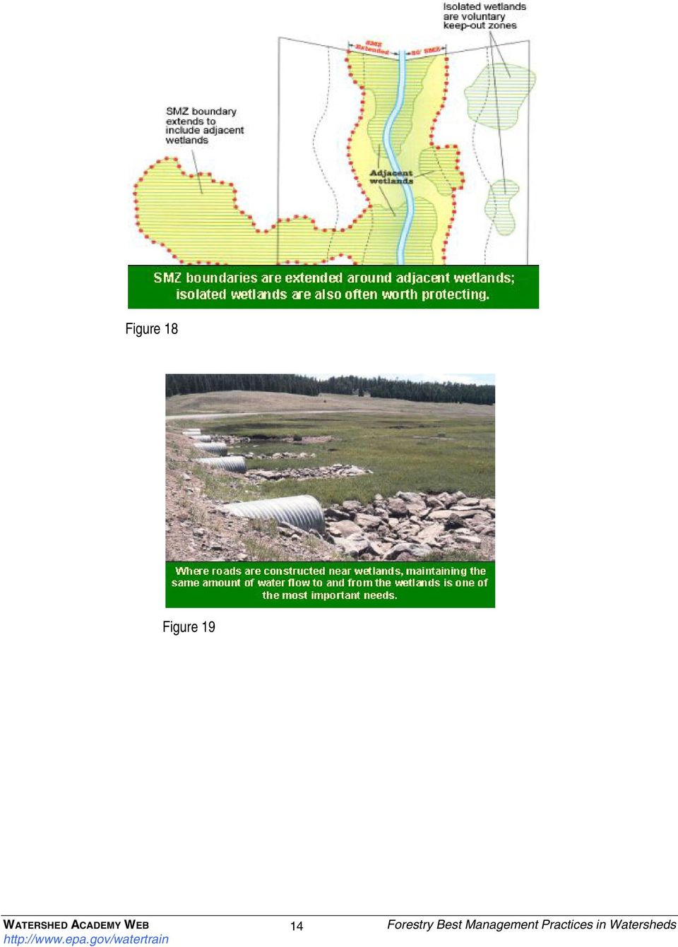
13 3. Forest Wetland Management* *Note: BMPs outlined below are examples. Check with the appropriate state agency to determine applicable BMPs in your area. Forest wetlands (Figures 16 and 17) provide many beneficial functions such as sediment trapping, nutrient retention and removal, groundwater recharge, and exceptional wildlife habitat. Normal, ongoing forestry activities (including harvesting, road design and construction, site preparation and regeneration, and chemical management) must be planned and operated to adequately protect the beneficial functions of forest wetlands. Figure 16 The Clean Water Act and state-level wetlands laws provide some regulatory protections (see wetlands/regs/index.html) that may affect actions such as depositing fill. Nevertheless, use of Best Management Practices may make several forestryrelated activities exempt from fill permit requirements (see section 232.3c (6) (i - xv) at 40cfr/232.html#232.03). Foresters should identify the provisions that apply to their plans before taking action and consult their local authorities for advice. Figure 17 The BMPs described for routine forestry activities are relevant to forested wetlands and, for certain activities, additional precautions are needed. For example: The streamside management zone should be extended to incorporate the wetlands nearby (Figure 18, overleaf). Ultrawide, high-flotation tires on logging trucks and skidders should be used to reduce soil compaction and erosion. Operations should be suspended or limited when soils become saturated. The natural contour of the site should be maintained and action should be taken to ensure that forestry activities do not immediately or gradually convert the wetland to dry land. Where roads are constructed, cross drainage should be provided to maintain natural surface and subsurface flow (Figure 19, overleaf). Construct road fills only when absolutely necessary. Gravel or crushed rock should be used as fill to provide for water movement. 13

14 Figure 18 Figure 19 14
15 3. Forest Wetland Management Quiz (Answers can be found on page 47.) 1. It is important to protect wetlands during timber harvest operations because these lands perform beneficial functions (habitat, filter pollutants). A. True. B. False. 2. What actions should be taken when harvest operations may impact wetlands? A. Incorporate wetlands into streamside management zones (SMZs). B. Drain wetlands so no special precautions are needed. C. Compact soils to reduce potential for erosion. D. Incorporate engineering solutions such as ultrawide, high-flotation tires to minimize compaction. E. A and C. F. A and D. G. A, B, and D. H. All of the above. 15

16 4. Road Construction and Maintenance* *Note: BMPs outlined below are examples. Check with the appropriate state agency to determine applicable BMPs in your area. Well-located, constructed, and maintained forest roads can minimize the major source of water pollution associated with silvicultural activities. A poorly designed road system (Figures 20 and 21) can result in significant impacts such as increased sediment load reaching the stream; landslide debris flows; degraded aquatic habitat and fish and wildlife migration barriers; stream bank and streambed damage; altered and concentrated surface runoff; and increased maintenance costs. Figure 20 Some general principles to consider in the layout of the road system are: Plan harvesting activities to minimize the total number of miles of road length. Use existing roads wherever possible. Minimize the changes in the natural stability of the land - place roads on high ground; keep out of streamside management zones and wet areas; keep off the toe of banks and slopes. Where possible, the road should follow the natural contour of the land. This will avoid the need for extensive cut and fill. Minimize the number of wet meadow and stream crossings. Keep road gradient as low as possible. The steeper the grades, the greater the velocity of the runoff. If steep grades are needed for short distances, follow by stretches of lesser grades to reduce runoff velocity (Figure 22). Determine the appropriate standard of road needed for the type of equipment; volume of traffic; and length of use. Selection of the appropriate road surfacing material will minimize erosion and reduce maintenance costs. Figure 21 16

17 Some general principles to consider in the construction of the road system are: Time the construction of the roads to minimize earth moving activities when soils are excessively wet and easily compacted and when fish are migrating and spawning and other critical times. Keep slope stabilization and erosion and sediment control work as current as possible with the road construction. This Figure 22 includes installing drainage features as part of the construction process and installing silt fences or windrows where needed to prevent sediment from entering streams (Figure 23). Place debris, overburden and other waste materials associated with construction in a location away from streams. Avoid placing these materials on unstable areas that may erode (Figure 24). Minimize soil erosion from road cuts and fills (Figure 25) through use of seeding, riprapping, mulching, or other methods to stabilize the soils and prevent weed invasion. Figure 23 Figure 24 Figure 25 17
.")
18 Some general principles to consider in ensuring proper drainage from road surfaces are: Where possible, use outsloped roads to drain water directly onto forest floor. Note that outsloping may present safety concerns on areas such as sharp curves (Figure 26). If roadside drainage ditches are required, drain water from these ditches frequently to avoid flow concentrations. Drain water collected along the slope of the backfill for insloped and crowned roads by transporting across the road Figure 26 (Figure 27) through culverts or surface cross drains such as water bars (small earthen dams formed in the road to force water off the road surface, out of the side ditches and onto the forest floor) or dips (short road gradient changes or steps which check and divert runoff). Waterbars and relief culverts should cross the road bed at an angle of between 30 and 45 degrees in order to provide gradient to the culvert and reduce the maintenance burden (debris will accumulate as the angle approaches a perpendicular alignment to the road). The spacing of the road cross drains (culverts, waterbars, dips) depends on the soil type, road gradient and amount of rainfall (Figure 28). Avoid placing drainage outlets on fill material since these materials are more readily eroded. Direct ditch waters onto undisturbed forest floor to allow water to infiltrate and sediment to settle out. Never drain road side ditches directly into streams. Figure 27 18
 through culverts or surface cross drains such as water bars")
19 Some general principles to consider constructing stream crossings (Figure 29) are: Figure 28 Design crossing to allow for fish passage and to protect water quality. Time construction to protect fish habitat and water quality. Design crossing to handle peak runoff and flood waters. Stream crossings should be at right angles to the stream channel and should include erosion protection measures. Crossings should be designed to protect the approach to the stream at the stream banks and stream bottom. Note that federal, state or local agencies may require permits for construction of stream crossings. The choice of stream crossing method depends on the stream type and size; size of the watershed drainage area; construction cost and maintenance; amount of use; length of use; soil condition (Figure 30). Culverts, bridges, or fords may be used to allow logging equipment to cross ephemeral, intermittent or perennial streams. Culverts are generally used when Figure 29 it is necessary to cross small streams. When installing culverts, the following practices should be considered: o Culverts should be oriented with the natural stream flow. 19

20 Figure 30 20

21 o Culverts must be designed and maintained to handle sediment and woody debris flow as well as stream flow. o Culverts should be designed to allow fish passage (Figure 31). o Erosion control measures, such as large boulders or riprap, should be installed to minimize sedimentation at culvert inflow and outfall. Figure 31 Bridges (Figure 32) are generally used when large streams are crossed. When constructing bridges, the following practices should be considered: o Bridges should be constructed with minimum disturbance to the stream bank, channel and SMZ. o Use portable, temporary bridges when possible. These are economical; can be installed with less impact on the environment than other alternatives; and can be easily removed upon completion of operations o Cross where the stream is relatively narrow with low banks and firm, rocky soil. The channel should be straight and uniform above, at, and below the crossing. Locate bridges so the stream and road alignment are perpendicular to one another and straight in all four directions. o Choose stream-crossing structures with the structural capacity to safely handle expected vehicle loads with the least disturbance to the watercourse. Consider stream size, storm frequency and flow rates, and intensity of use (permanent or temporary). 21
22 Figure 32 Fords (Figure 33) may be used if no practical alternative exists. o The use of fords should be limited to areas where the stream bed has a firm rock or gravel bottom. There are several options to harden the bottom of fords including gravel and concrete or wooden planks o The approaches to fords should be both low and stable enough to support traffic. o No fish should be present during low flow. o The water depth should be low enough to allow safe passage. In general, timber harvesters should avoid impacts to wetlands and other aquatic resources to the maximum extent practicable. If a proposed road project would impact a wetland, it may require authorization under Section 404 of the Clean Water Act. In such cases, contact the Army Corps of Engineers local office to determine whether Section 404 applies to your project. Section 404 exempts discharges of dredged or fill material associated with forest road construction and maintenance, where such activities are conducted in accordance with specific Best Management Practices. Figure 33 22
23 Some general principles to consider in constructing wetland crossings are: Use multiple culverts to preserve the existing hydrology For temporary roads, consider the use of support systems such as geotextiles and various wood and metal platform devices (Figure 34). Schedule the harvest during the drier seasons of the year or during time when the ground is frozen. Consider ceasing operations in areas where rutting exceeds 6 inches in depth. Do not skid (drag cut logs) through vernal ponds, spring seeps, or stream channels. Use brush or corduroy roads (rows of logs or limbs) to minimize soil compaction and rutting when skidding in wet areas. Consider chiseling to break up compacted road surface to reestablish soil porosity when hauling is completed. Some general principles of road maintenance to consider are: Figure 34 Road surface should be free of ruts to keep traffic moving safely. The road should be bladed and reshaped to conserve existing material; and to retain the original insloped, outsloped, or crowned design (Figure 35). Fill and side cast areas must be checked to make sure they aren t becoming saturated and unstable. Inspections to ensure water control measures are functioning properly are essential. To keep water flowing freely and quickly away from the road, culverts must be free of debris. Water bars and dips must be maintained as traffic wears them down. Figure 35 23
24 4. Road Construction and Management Quiz (Answers can be found on page 47.) 1. What factors should be considered in designing the road system for a timber harvest? A. Locate roads as close to stream as possible since this is usually the lowest gradient. B. Follow natural contour of the land. C. Minimize the miles of roads needed. D. Minimize the number of stream crossings. E. C and D. F. B and C. G. B, C, and D. H. All of the above. 2. What are some general practices which can be followed to minimize the environmental impacts of the road construction? A. B. C. Schedule work to avoid times when soils are wet, when fish are migrating, and other sensitive times. Keep erosion control work, such as stabilizing slopes and installing drainage systems and silt fences, as current as possible with road construction. Keep all waste materials from road construction away from streams. D. A and C. E. A, B, and C. F. B and C. G. None of the above. 3. Outsloped road construction is preferred where possible because this allows water to drain directly from the road surface onto the forest floor avoiding the need for road side ditches, water bars, cross drain culverts, and other drainage systems to move the water from the road without impacting any streams. A. B. True. False. 24
25 4. What are some stream crossing design considerations? A. Crossing design and construction timing should consider fish passage and fish habitat protection. B. Crossing design should be able to handle a 10 year flood maximum. C. Culverts are generally used to cross small streams. D. Fords are generally used for streams which will be infrequently crossed. E. Bridges are generally used to cross large streams. F. A and B. G. C and E. H. A, C, and E. I. All of the above. 5. What kind of road maintenance operations should be performed? A. B. C. Make annual inspections to ensure drainage systems are operating properly. Reconstruct water bars and dips as traffic wears them down. Blade road as needed to retain original road inslope, outslope, or crown design. D. A and C. E. B and C. F. All of the above. 25
26 5. Timber Harvesting* *Note: BMPs outlined below are examples. Check with the appropriate state agency to determine applicable BMPs in your area. Timber harvesting consists of felling the tree, transporting (yarding) to a central accumulation point (landing), and transporting logs offsite along the main haul roads. Each of these activities can have minimal to severe impacts on water quality, depending in part on the level of planning and the implementation of best management practices (Figures 36 and 37). Of primary importance are the density and location of skid trails, type of yarding system selected, soil compaction and saturation, and amount of soil disturbance. Figure 36 Types of yarding systems include tractor/skidder, skyline, and helicopter logging (Figure 38). Figure 37 Figure 38 26
27 Tractor/skidder systems haul logs to a landing by tractor or skidder along skid trails (Figure 39). This is the least expensive and most common type of system, but it also can have the most impact on nearby waters if done carelessly. Impacts can be reduced through practices such as the following: o Skid trails should be carefully laid out to minimize the number of trails. o Skid trails should be clearly marked. Skid trails should not be located in streambeds, in SMZs, or on steep slopes. o Skidding should be upslope or on the topographic contour to disperse runoff. o Appropriate drainage control measures, such as water bars, should be installed on skid trails to protect water quality. Figure 39 Figure 40 Skyline systems move logs to the landing by aerial cables (Figure 40). This is used where there are long, steep slopes or where it is necessary to protect soils from excessive disturbance and to maintain integrity of sensitive areas. Helicopters move logs to the landing by helicopter (Figure 41). This method is used primarily in rugged terrain where good landing sites and roads are not very close to the harvest areas, or where there are exceptionally sensitive environmental features that may be affected by other yarding methods or new road construction. Landings for any of the above transport systems should be located in dry areas with slight slopes, well outside streamside management zones or wetlands. The number and size of landings should be planned along with the harvest road system considering the yarding system selected. There must be adequate drainage on approach trails to the landing and a mechanism to divert water away from the landing. 27
28 The ability to grow the next forest depends on protecting the soil. After completion of harvesting operations, landings and access roads must be stabilized. Regrade and revegetate the surface of landings and access roads so they are smooth, level, and free of ruts. Heavily compacted areas may require scarification or disking to promote water infiltration. Figure 41 28
29 5. Timber Harvesting Quiz (Answers can be found on page 47.) 1. The three types of yarding systems are tractor/skidder, skyline, and helicopter. What factors should be considered in selecting which of these yarding systems will be used? A. The topography of the harvest site. B. The value of the timber. C. The environmentally sensitive areas within the harvest boundary. D. Potential for soil compaction or disturbance. E. A and D. F. B and C. G. A, C, and D. H. None of the above. 2. The landing should be located outside the SMZ in a dry area with a slight slopes to drain water from the site. A. B. True False 29
30 6. Revegetation and Forest Regeneration* *Note: BMPs outlined below are examples. Check with the appropriate state agency to determine applicable BMPs in your area. After an area is harvested, tree stumps, trees too small to harvest, and woody debris are left behind (Figures 42 and 43). This condition sometimes presents a potential fire hazard which can, in turn, lead to increased runoff and stream sedimentation. In addition, there are numerous roads, skid trails, and drainage structures which are no longer needed. If these are not properly closed or maintained, they are a source of sediment contamination. The immediate goal of site preparation is to get desired vegetation back on the site as soon as possible to Figure 42 control erosion, sedimentation, and nutrient loss. Through systematic planning and implementation of appropriate BMPs, we can minimize adverse impacts from past timber harvesting. Site preparation can include: Removal of logging roads, landings, and drainage structures. Mechanical activities to chop, root rake, disk and blade the soil in the disturbed areas in preparation for planting. Prescribed fires to reduce logging residue and undesirable trees and vegetation (also see the next section of this module). Each of these actions or a combination of these actions has the potential for increasing erosion and Figure 43 degrading water quality. Equipment and site preparation methods must consider the site topography, soil type, natural drainage, amount of rainfall, and kind of vegetation. 30
31 Some general principles of revegetation and reforestation to consider are (Figure 44): Establish a vegetative cover planting on erodible areas that were cultivated in the fall but will not be planted until spring. Stabilize steep slopes prior to planting. Use native grasses or other plant species to reseed bare-erodible areas; do not introduce invasive non-native plants under any circumstance (Figure 45). Windrow logging debris along contours, in gullies, and on skid trails to stabilize these areas. Remove unneeded logging roads and skid trails immediately. Do not wait for entire harvest operation to be completed. Smooth, grade and revegetate landings and, where appropriate, main haul roads. Remove temporary drainage structures and clean permanent drainage structures. Figure 44 Figure 45 31
32 6. Revegetation and Forest Regeneration Quiz (Answers can be found on page 47.) 1. A site preparation plan is necessary to ensure the harvest is conducted in an environmentally sound manner. A. True B. False 2. The site preparation plan should describe the steps which will be taken to get desired vegetation back on the site as soon as possible after the timber harvest. A True B. False 32
33 7. Fire Management* *Note: BMPs outlined below are examples. Check with the appropriate state agency to determine applicable BMPs in your area. Fire is an important tool in forest management and a natural occurrence that sometimes requires control or suppression. Practices for protecting water quality relate to two general categories of fire management: wildfire control and prescribed burning. Prescribed burning reduces slash, competition for nutrients among seedlings, and fuel for wildfires. Where tree species are ecologically dependent on fire for regeneration, fire also serves as an essential forest management tool. Periodic, low-intensity prescribed fires usually have little effect on water quality, and revegetation of burned areas reduces sediment yield from prescribed burning and wildfires. Figure 46 The intensity and severity of burning and the proportion of the watershed burned are the major influences on streamflow and water quality (Figures 46 and 47). Fires that burn intensely on steep slopes close to streams and that remove most of the forest floor and litter down to the mineral soil are most likely to affect water quality by increasing sediment and nutrient pollution in the water. Simultaneously, intense fires decrease soil nutrients and increase soil erosion. Figure 47 33
34 The amount of erosion following a fire depends on: The amount of ground cover remaining on the soil The steepness of the slope (Figure 48) The time, amount, and intensity of rainfall The intensity of fire The erodibility of the soil How rapidly a site revegetates Wildfire and prescribed fire change erosion rates on the burned area in two ways. First, fire eliminates vegetative soil cover (Figure 49). Second, chemical changes in the soil following fire create an increased resistance to water infiltration in the upper soil layer, and this increases surface runoff and sheet erosion. The magnitude of these effects depends on how hot a fire burns, and this in turn depends on numerous site characteristics. Erosion Figure 48 following fire is most severe where a fire has burned most intensely and the fire is followed by a strong storm, a year of moderately high rainfall, or a spring with a large volume of snowmelt. Wildfire control practices helpful to water quality include: Whenever possible avoid using fire-retardant chemicals in SMZs and over watercourses, and prevent their runoff into watercourses. Do not clean application equipment in watercourses or locations that drain into watercourses. Close water wells excavated for wildfire-suppression activities as soon as practical following fire control. Figure 49 34
35 During wildfire emergencies, firelines, road construction, and stream crossings are unrestricted by BMPs. However, install BMPs and begin remediation as soon as possible after the emergency is controlled. Studies have shown that prescribed burning, if carefully planned and done using appropriate BMPs, can avoid significant effects on water quality. Prescribed fire BMPs include: Carefully plan burning to take into account weather, time of year, and fuel conditions so that these help achieve the desired results and minimize effects on water quality. Do not conduct intense prescribed fire for site preparation in the SMZ. Do not pile and burn for slash removal purposes in the SMZ, and avoid construction of firelines in the SMZ or immediately adjacent or parallel to the SMZ. Prescribe burns should be only as intense as necessary to achieve the desired objective (Figure 50). If possible, burn to maintain some of the duff or residual organic matter on the soil to prevent soil erosion. Avoid conditions that require extensive blading of fire lines by heavy equipment when prescribing burns. Use handlines, firebreaks, and hose lays to minimize blading of fire lines. Execute the burn with a trained crew and avoid intense burning (Figure 51). Figure 50 Avoid burning on steep slopes in high-erosionhazard areas or areas that have highly erodible soils. Note that State, county, and local governments may have air pollution or smoke management requirements for prescribed burns. Figure 51 35
36 Some general principles of fire management to follow for protecting water resources are: Intense prescribed fire should not cause excessive sedimentation due to the combined effect of removal of canopy species and the loss of soil-binding ability of subcanopy and herbaceous vegetation roots (Figure 52), especially in SMZs, in streamside vegetation for small ephemeral drainages, or on very steep slopes. Prescriptions for prescribed fire should protect against excessive erosion or sedimentation to the extent practicable. All bladed firelines, for prescribed fire and wildfire, should be plowed on contour or stabilized with water bars and/or other appropriate techniques if needed to control excessive sedimentation or erosion of the fireline. Wildfire suppression and rehabilitation should consider possible nonpoint source pollution of watercourses, while recognizing the safety and operational priorities of fighting wildfires. Figure 52 36
37 7. Fire Management Quiz (Answers can be found on page 47.) 1. During a prescribed burn that is going according to plan, all actions are unrestricted by BMPs. A. B. True False 2. The potential negative impacts of fire on water resources come mostly from erosion, sedimentation, and nutrients. A. B. True False 3. Extensive blading of firelines has a negligible effect on erosion and water quality. A. B. True False 4. Prescribed burns usually have negligible effects on water resources. A. B. True False 37
38 8. Forest Chemicals* *Note: BMPs outlined below are examples. Check with the appropriate state agency to determine applicable BMPs in your area. Over the last several years, many chemical compounds including pesticides, fertilizers, and fire retardants have been used in forestry to increase production. These chemicals have the potential, if improperly used, to pollute soil and water and damage wildlife habitats (Figure 53). To ensure safe use of chemicals, consider the following: Transportation, handling, storage, application and disposal of pesticides, fire retardants, and fertilizers must comply with Figure 53 applicable local, state and federal regulations (Figure 54). Monitor weather conditions such as rain, wind speed, temperature and humidity during application to prevent drift, volatilization, and surface water runoff. Do not apply chemicals in streamside management zones or wetlands. Note that fertilizers and fire retardants contain high amounts of both nitrogen and phosphorus and are easily transported overland and deposited in stream along with the sediment. These compounds can accelerate eutrophication (a process whereby water bodies are choked by overabundant plant life and algae due to higher levels of nutrients such as nitrogen and phosphorus). Oil and fuel for equipment and vehicles must also be carefully handled and disposed. Spills, leaks, empty containers, and filters are potential sources of soil and water contamination if improperly managed. Develop a spill contingency plan which identifies all actions to be taken in the event of a chemical spill including phone numbers for federal, state, and local Figure 54 agencies which must be notified. 38
39 8. Forest Chemicals Quiz (Answers can be found on page 47.) 1. Chemicals, such as pesticides, fertilizers, and fire retardants, are used in forestry activities to increase production A. B. True False 2. What steps can be taken to ensure save use of chemicals in forestry activities? A. Develop a spill contingency plan. B. Do not use or store chemicals in the SMZ. C. Dispose of empty chemical containers by burying on site. D. Monitor weather conditions before and during chemical application. E. A, B, and D. F. B and D. G. A and C. H. All of the above. 39
40 Module Conclusion If you have completed this module, you should now have basic awareness of the types of general activities involved in forestry, the kinds of adverse effects on aquatic systems that improper or careless forest practices might cause, and several general practices for minimizing these adverse effects (Figure 55). You had the opportunity to answer review questions after each of eight module sections. All the questions are reassembled on the following pages in a final self-test of your retention. Figure 55 Appreciation is expressed to the States of Montana and Wyoming for the use of numerous graphics and photographs from their stream management and forest BMP publications, and for the use of their BMPs as examples in this module. Thanks also to reviewers Melissa DeSantis, Bill Kirchner, George Loeb, Sam Pett, Steve Ralph, Chris Solloway, Dov Weitman, and Alan Wright for their helpful comments. Self Test on Choose the appropriate response to each question below. After you ve completed the quiz, check your answers with the ones provided on the last page of this document. A passing grade is 18 of 25 correct, or 70%. Answers can be found on page 47. Part I: 1. What is the purpose of a preharvest plan? A. B. C. D. Identify potential problem areas. Reduce the potential for nonpoint source pollution. Maximize timber harvest. Identify Best Management Practices. E. A and B. F. A and C. G. A, B and D. H. None of the above. 40
41 2. What information should be included in preharvest plan? A. B. C. D. A delineation of the harvest boundary. BMPs for only the timber harvest itself. Location of sensitive environmental areas. Employee information. E. B and C. F. A and C. G. A, B and D. H. None of the above. 3. What are some of the steps to take to minimize environmental impact? A. B. C. D. Avoid sensitive environmental areas when possible. Work when soils are saturated. Design road system to take advantage of topography. Obtain easements from adjacent landowners if this will result in a more efficient road system. E. A and C. F. B and C. G. A, C and D. H. All of the above. 4. What is a streamside management zone? A. B. C. Ten feet or more of undisturbed forest on both sides of a stream. A buffer zone between land activities and the stream which acts as a filter for pollutants. A preferred area for location of roads. D. A and B. E. None of the above. 41
42 5. What are some of the harvesting precautions which should be taken in SMZs? A. B. C. D. Limit disturbances in the SMZs. Do not allow any timber harvesting in the SMZ. Place logging debris in stream channel for fish habitat. Keep all pesticides and fertilizers out of the SMZ. E. A and D. F. B and C. G. A, C and D. H. All of the above. 6. What are some of the factors to consider in selecting the size of the SMZ? A. B. C. D. Ground slope and soil stability. Location of wetlands and sensitive environmental areas. Volume of timber available for harvest. Time of the year of the harvest operation. E. A and C. F. B and C. G. A and B. H. All of the above. 7. What actions should be taken when harvest operations may impact wetlands? A. Incorporate wetlands into streamside management zones (SMZs). B. Drain wetlands so no special precautions are needed. C. Compact soils to reduce potential for erosion. D. Incorporate engineering solutions such as ultrawide, high-flotation tires to minimize compaction. E. A and C. F. A and D. G. A, B, and D. H. All of the above. 42
43 8. What factors should be considered in designing the road system for a timber harvest? A. Locate roads as close to stream as possible since this is usually the lowest gradient. B. Follow natural contour of the land. C. Minimize the miles of roads needed. D. Minimize the number of stream crossings. E. C and D. F. B and C. G. B, C, and D. H. All of the above. 9. What are some general practices which can be followed to minimize the environmental impacts of the road construction? A. Schedule work to avoid times when soils are wet, when fish are migrating, and other sensitive times. B. C. Keep erosion control work, such as stabilizing slopes and installing drainage systems and silt fences, as current as possible with road construction. Keep all waste materials from road construction away from streams. D. A and C. E. A, B, and C. F. B and C. G. None of the above. 10. What are some stream crossing design considerations? A. Crossing design and construction timing should consider fish passage and fish habitat protection. B. Crossing design should be able to handle a 10 year flood maximum. C. Culverts are generally used to cross small streams. D. Fords are generally used for streams which will be infrequently crossed. E. Bridges are generally used to cross large streams. F. A and B. G. C and E. H. A, C, and E. I. All of the above. 43
44 11. What kind of road maintenance operations should be performed? A. Make annual inspections to ensure drainage systems are operating properly. B. Reconstruct water bars and dips as traffic wears them down. C. Blade road as needed to retain original road inslope, outslope, or crown design. D. A and C. E. B and C. F. All of the above. 12. The three types of yarding systems are tractor/skidder, skyline, and helicopter. What factors should be considered in selecting which of these yarding systems will be used? A. The topography of the harvest site. B. The value of the timber. C. The environmentally sensitive areas within the harvest boundary. D. Potential for soil compaction or disturbance. E. A and D. F. B and C. G. A, C, and D. H. None of the above. 13. What steps can be taken to ensure save use of chemicals in forestry activities? A. Develop a spill contingency plan. B. Do not use or store chemicals in the SMZ. C. Dispose of empty chemical containers by burying on site. D. Monitor weather conditions before and during chemical application. E. A, B, and D. F. B and D. G. A and C. H. All of the above. 44
45 Part It is important to protect wetlands during timber harvest operations because these lands perform beneficial functions (habitat, filter pollutants). A. True. B. False. 15. Outsloped road construction is preferred where possible because this allows water to drain directly from the road surface onto the forest floor avoiding the need for road side ditches, water bars, cross drain culverts, and other drainage systems to move the water from the road without impacting any streams. A. True. B. False. 16. The landing should be located outside the SMZ in a dry area with a slight slopes to drain water from the site. A. True B. False 17. A site preparation plan is necessary to ensure the harvest is conducted in an environmentally sound manner. A. True B. False 18. The site preparation plan should describe the steps which will be taken to get desired vegetation back on the site as soon as possible after the timber harvest. A. True B. False 19. During a prescribed burn that is going according to plan, all actions are unrestricted by BMPs. A. True B. False 20. The potential negative impacts of fire on water resources come mostly from erosion, sedimentation, and nutrients. A. True B. False 45
46 21. Extensive blading of firelines has a negligible effect on erosion and water quality. A. True B. False 22. Prescribed burns usually have negligible effects on water resources. A. True B. False 23. Chemicals, such as pesticides, fertilizers, and fire retardants, are used in forestry activities to increase production A. True B. False 24. Temperature and humidity are weather factors which should be monitored when using forest chemicals. A. True B. False 25. The only problem forest chemicals can cause to water resources is toxic pollution. A. True B. False 46
47 Answers: 1. Pre Harvest BMPs (Page 9) Q1: G Q2: F Q3: G 2. Streamside Management Zones (SMZs) (Page 12) Q1: B Q2: E Q3: G 3. Forest Wetland Management (Page 15) Q1: A Q2: F 4. Road Construction and Maintenance (Pages 22-25) Q1: G Q2: E Q3: A Q4: H Q5: E 5. Timber Harvesting (Page 29) Q1: G Q2: A 6. Revegetation and Forest Regeneration (Page 32) Q1: B Q2: A 7. Fire Management (Page 37) Q1: B Q2: A Q3: B Q4: A 8. Forest Chemicals (Page 39) Q1: A Q2: E Answers to Self Test on Forestry Best Management Practices in Watersheds (Pages 40-46) Part I: Q1: G Q2: F Q3: G Q4: B Q5: E Q6: G Q7: F Q8: G Q9: E Q10: H Q11: E Q12: G Q13: E Part II: Q14: A Q15: A Q16: A Q17: B Q18: A Q19: B Q20: A Q21: B Q22: A Q23: A Q24: A Q25: B 47
Post-Wildfire Clean-Up and Response in Houston Toad Habitat Best Management Practices
 Post-Wildfire Clean-Up and Response in Houston Toad Habitat Best Management Practices Purpose The purpose of this document is to provide guidance and recommendations for minimizing potential impacts to
Land Disturbance, Erosion Control and Stormwater Management Checklist. Walworth County Land Conservation Department
 Land Disturbance, Erosion Control and Stormwater Management Checklist Walworth County Land Conservation Department The following checklist is designed to assist the applicant in complying with the Walworth
Chapter 3 CULVERTS. Description. Importance to Maintenance & Water Quality. Culvert Profile
 Chapter 3 CULVERTS Description A culvert is a closed conduit used to convey water from one area to another, usually from one side of a road to the other side. Importance to Maintenance & Water Quality
Outlet stabilization structure
 Overview of Sedimentation and Erosion Control Practices Practice no. 6.41 Outlet stabilization structure Erosion at the outlet of channels, culverts, and other structures is common, and can cause structural
How To Plan A Buffer Zone
 Backyard Buffers Protecting Habitat and Water Quality What is a buffer? A buffer (also called a riparian buffer area or zone) is the strip of natural vegetation along the bank of a stream, lake or other
Construction Site Inspection Checklist for OHC000004 By making use of some simple Best Management Practices (BMPs) a construction site operator can
 a construction site operator can") Construction Site Inspection Checklist for OHC000004 By making use of some simple Best Management Practices (BMPs) a construction site operator can do his or her share to protect Ohio's water resources
Construction Site Inspection Checklist for OHC000004 By making use of some simple Best Management Practices (BMPs) a construction site operator can do his or her share to protect Ohio's water resources
Chapter 11 Site Rehabilitation and Stabilization
 Chapter 11 Site Rehabilitation and Stabilization Chapter 11 Layout: Part 1 - Page 131 Planning Site Rehab Part 2 - Page 132 Controlling Runoff and Capturing Sediment Part 3 - Page 133 Rehab for Crossings
City of Shelbyville Site Inspection Checklist
 City of Shelbyville Site Inspection Checklist General Information Project Name: KYR10 Permit Number: Date: Project Location: Contractor: Conractor Representative: Inspector's Name: Title: Signature : Weather
Index. protection. excavated drop inlet protection (Temporary) 6.50.1 6.51.1. Block and gravel inlet Protection (Temporary) 6.52.1
 6.50.1 6.51.1. Block and gravel inlet Protection (Temporary) 6.52.1") 6 Index inlet protection excavated drop inlet protection (Temporary) 6.50.1 HARDWARE CLOTH AND GRAVEL INLET PROTECTION Block and gravel inlet Protection (Temporary) sod drop inlet protection ROCK DOUGHNUT
6 Index inlet protection excavated drop inlet protection (Temporary) 6.50.1 HARDWARE CLOTH AND GRAVEL INLET PROTECTION Block and gravel inlet Protection (Temporary) sod drop inlet protection ROCK DOUGHNUT
SUSTAINABLE URBAN DRAINAGE SYSTEMS
 overflow can lead into a permeable conveyance system to increase further the benefit and reduce the need for pipe systems. Pollutant removal rates have been shown to be high, with some pollutants being
City of Paso Robles Community Development Department Construction Site Storm Water Quality Requirements
 City of Paso Robles Community Development Department Construction Site Storm Water Quality Requirements Overview of the City s Construction Storm Water Program The City of Paso Robles is committed to protecting
A Developer s Guide: Watershed-Wise Development
 A Developer s Guide: Watershed-Wise Development Environmental Protection What is a watershed? It does not matter how far away you build from a creek, lake, or the ocean, you are in a watershed. Another
Agricultural and Forestry Activities
 Agricultural and Forestry Activities EROSION AND SEDIMENTATION CONTROL PLANNING AND DESIGN WORKSHOP APRIL 14, 2015 Presentation Overview Agricultural Exemption Sedimentation Pollution Control Act (SPCA)
CHAPTER 3A Environmental Guidelines for STREAM CROSSING BY ALL-TERRAIN VEHICLES
 GOVERNMENT OF NEWFOUNDLAND AND LABRADOR DEPARTMENT OF ENVIRONMENT AND LABOUR CHAPTER 3A Environmental Guidelines for STREAM CROSSING BY ALL-TERRAIN VEHICLES WATER RESOURCES MANAGEMENT DIVISION Water Investigations
1.7.0 Floodplain Modification Criteria
 1.7.0 Floodplain Modification Criteria 1.7.1 Introduction These guidelines set out standards for evaluating and processing proposed modifications of the 100- year floodplain with the following objectives:
Angora Fire Restoration Activities June 24, 2007. Presented by: Judy Clot Forest Health Enhancement Program
 Angora Fire Restoration Activities June 24, 2007 Presented by: Judy Clot Forest Health Enhancement Program California Tahoe Conservancy Independent California State Agency within the Resources Agency Governed
SE-10 STORM DRAIN INLET PROTECTION. Objectives
 STORM DRAIN INLET PROTECTION SE-10 Objectives Erosion Control - EC Sediment Control - SE Tracking Control - TC Wind Erosion Control - WE Non-Storm Water Management - NS Waste and Materials Management -
SITE-SPECIFIC BEST MANAGEMENT PRACTICES (SSBMP) PLAN/STORM WATER POLLUTION PREVENTION PLAN (SWPPP) REVIEW CHECKLIST
 PLAN/STORM WATER POLLUTION PREVENTION PLAN (SWPPP) REVIEW CHECKLIST") This checklist may be used by applicants for encroachment permits, and contractors in development of Site Specific Best Management Practice (SSBMP) Plans or Storm Water Pollution Prevention Plans (SWPPP)
This checklist may be used by applicants for encroachment permits, and contractors in development of Site Specific Best Management Practice (SSBMP) Plans or Storm Water Pollution Prevention Plans (SWPPP)
COLORADO DEPARTMENT OF TRANSPORTATION STORMWATER FIELD INSPECTION REPORT - ACTIVE CONSTRUCTION
 COLORADO DEPARTMENT OF TRANSPORTATION STORMWATER FIELD INSPECTION REPORT - ACTIVE CONSTRUCTION (1) Project Name: (2) Project Contractor: (3) Erosion Control Supervisor/SWMP Administrator: (4) CDOT Project
REPORT TO REGIONAL WATER SUPPLY COMMISSION MEETING OF WEDNESDAY, SEPTEMBER 4, 2013 LEECH WATER SUPPLY AREA RESTORATION UPDATE
 Making a difference... together Agenda Item #9 REPORT #RWSC 2013-17 REPORT TO REGIONAL WATER SUPPLY COMMISSION MEETING OF WEDNESDAY, SEPTEMBER 4, 2013 SUBJECT LEECH WATER SUPPLY AREA RESTORATION UPDATE
Chapter 2 Stormwater Pollution Prevention Plan (SWPPP) for Park Operations
 for Park Operations") SWPPP for Park Operations 2 Chapter 2 Stormwater Pollution Prevention Plan (SWPPP) for Park Operations Bordered by Lake Washington & Lake Sammamish, the City of Bellevue has more than 60 miles of streams,
SWPPP for Park Operations 2 Chapter 2 Stormwater Pollution Prevention Plan (SWPPP) for Park Operations Bordered by Lake Washington & Lake Sammamish, the City of Bellevue has more than 60 miles of streams,
DOÑA ANA COUNTY DESIGN STORM CRITERIA GUIDELINES FOR COMMERCIAL AND RESIDENTIAL SITES. Run-off Analysis Methods
 DOÑA ANA COUNTY DESIGN STORM CRITERIA GUIDELINES FOR COMMERCIAL AND RESIDENTIAL SITES Run-off Analysis Methods This document sets forth the minimum design, technical criteria and specifications for the
SITE-SPECIFIC BEST MANAGEMENT PRACTICES (BMP) PLAN REVIEW CHECKLIST
 PLAN REVIEW CHECKLIST") This checklist may be used by applicants for encroachment permits, and contractors in development of Site- Specific BMP Plans for projects. plan reviewers will use this checklist to review the Site-Specific
This checklist may be used by applicants for encroachment permits, and contractors in development of Site- Specific BMP Plans for projects. plan reviewers will use this checklist to review the Site-Specific
REFERENCE. All National Grid personnel who plan and perform work involving protected water resources are responsible for:
 EG-30NY ENVIRONMENTAL GUIDANCE PAGE 1 of 9 DATE 10/1/10 EP 3 Natural Resource Protection 1.0 SCOPE AND RESPONSIBILITIES National Grid s New York service territory encompasses thousands of wetlands, lakes,
COMPREHENSIVE PLAN SECTION B, ELEMENT 4 WATER RESOURCES. April 20, 2010 EXHIBIT 1
 COMPREHENSIVE PLAN SECTION B, ELEMENT 4 WATER RESOURCES April 20, 2010 EXHIBIT 1 ELEMENT 4 WATER RESOURCES TABLE OF CONTENTS 4.1 INTRODUCTION 4.2 GOALS AND POLICIES 4.2.A General Goals and Policies 1 4.2.B
CONSTRUCTION STORMWATER POLLUTION PREVENTION PLAN TEMPLATE
 CONSTRUCTION STORMWATER POLLUTION PREVENTION PLAN TEMPLATE The following template may be used as a general guide for development of a Stormwater Pollution Prevention Plan (SWPPP) for construction activities.
CITY UTILITIES DESIGN STANDARDS MANUAL
 CITY UTILITIES DESIGN STANDARDS MANUAL Book 2 (SW) SW9 June 2015 SW9.01 Purpose This Chapter provides information for the design of open channels for the conveyance of stormwater in the City of Fort Wayne.
Mississippi s BMPs. Best Management Practices for Forestry in Mississippi
 Mississippi s BMPs Best Management Practices for Forestry in Mississippi Mississippi s BMPs Best Management Practices for Forestry in Mississippi The Best Management Practices Handbook was developed by
CLACKAMAS COUNTY ZONING AND DEVELOPMENT ORDINANCE
 1008 STORM DRAINAGE (3/24/05) 1008.01 PURPOSE To minimize the amount of stormwater runoff resulting from development utilizing nonstructural controls where possible, maintain and improve water quality,
Chapter 3 SENSITIVE AREAS AND VEGETATED CORRIDORS
 Chapter 3 3.01 General Provisions 3.01.1 Introduction 3.01.2 Application and Interpretation of Chapter 3.01.3 Unbuildable Lots 3.01.4 Other Permits 3.01.5 Prohibited Activities 3.02 Service Provider Letter
King Fire Restoration Project, Eldorado National Forest, Placer and El Dorado Counties, Notice of intent to prepare an environmental impact statement.
 This document is scheduled to be published in the Federal Register on 12/24/2014 and available online at http://federalregister.gov/a/2014-30158, and on FDsys.gov [3410-11- P] DEPARTMENT OF AGRICULTURE
Adopted 9/23/98 CHATTAHOOCHEE CORRIDOR PLAN. The goals of the Chattahoochee Corridor Plan (hereinafter also referred to as the Plan ) are:
 are:") CHATTAHOOCHEE CORRIDOR PLAN Adopted 9/23/98 PART 1: GOALS. POLICY. COVERAGE. A. Goals The goals of the Chattahoochee Corridor Plan (hereinafter also referred to as the Plan ) are: 1. Preservation and protection
CHATTAHOOCHEE CORRIDOR PLAN Adopted 9/23/98 PART 1: GOALS. POLICY. COVERAGE. A. Goals The goals of the Chattahoochee Corridor Plan (hereinafter also referred to as the Plan ) are: 1. Preservation and protection
Interlocking Concrete Pavement Institute (ICPI) Model Stormwater Ordinance for Permeable Interlocking Concrete Pavements August 2010
 Model Stormwater Ordinance for Permeable Interlocking Concrete Pavements August 2010") Interlocking Concrete Pavement Institute (ICPI) Model Stormwater Ordinance for Permeable Interlocking Concrete Pavements August 2010 Background What are permeable interlocking concrete pavements (PICP)?
Interlocking Concrete Pavement Institute (ICPI) Model Stormwater Ordinance for Permeable Interlocking Concrete Pavements August 2010 Background What are permeable interlocking concrete pavements (PICP)?
SECTION 5. Sediment Control Measures
 SECTION 5 Sediment Control Measures 60. STORM DRAIN INLET PROTECTION When Runoff from earth change activities will discharge to a catch basin or storm drain inlet. A newly constructed catch basin or storm
PRIVATE TREATMENT CONTROL BMP OPERATION AND MAINTENANCE VERIFICATION FORM BIORETENTION FACILITIES, VEGETATED SWALES & HIGHER RATE BIOFILTERS
 BIORETENTION FACILITIES, VEGETATED SWALES & HIGHER RATE BIOFILTERS Check here for Address or phone number change the fiscal year (July 1 June 30), and date(s) maintenance was performed. Under Inspection,
Low Impact Development Checklist
 New Jersey Stormwater Best Management Practices Manual February 2004 A P P E N D I X A Low Impact Development Checklist A checklist for identifying nonstructural stormwater management strategies incorporated
GLOSSARY OF TERMS CHAPTER 11 WORD DEFINITION SOURCE. Leopold
 CHAPTER 11 GLOSSARY OF TERMS Active Channel The channel that contains the discharge Leopold where channel maintenance is most effective, sediment are actively transported and deposited, and that are capable
The Basics of Chapter 105 Waterways and Wetlands Permitting in PA
 The Basics of Chapter 105 Waterways and Wetlands Permitting in PA April 17, 2013 Goal To develop a basic understanding of PA Department of Environmental Protection (DEP) and US Army Corps of Engineers
Storm Drain Inlet Protection
 Objectives EC Erosion Control SE Sediment Control TR Tracking Control WE Wind Erosion Control Non-Stormwater NS Management Control Waste Management and WM Materials Pollution Control Legend: Primary Objective
Detention Ponds. Detention Ponds. Detention Ponds. Detention Ponds. Detention Ponds. Detention Ponds. CIVL 1112 Detention Ponds - Part 1 1/12
 CIVL 1112 - Part 1 1/12 The water cycle, also known as the hydrologic cycle, describes the continuous movement of water on, above and below the surface of the Earth. The water cycle, also known as the
Homeowner s Guide to Drainage
 Homeowner s Guide to Drainage a scottsdale homeowner s guide to drainage produced by the city of scottsdale s stormwater management division Transportation Department TABLE OF CONTENTS Introduction 2 Drainage
IAC 7/2/08 Utilities[199] Ch 9, p.1 CHAPTER 9 RESTORATION OF AGRICULTURAL LANDS DURING AND AFTER PIPELINE CONSTRUCTION
![IAC 7/2/08 Utilities[199] Ch 9, p.1 CHAPTER 9 RESTORATION OF AGRICULTURAL LANDS DURING AND AFTER PIPELINE CONSTRUCTION](/thumbs/39/18416513.jpg "IAC 7/2/08 Utilities[199] Ch 9, p.1 CHAPTER 9 RESTORATION OF AGRICULTURAL LANDS DURING AND AFTER PIPELINE CONSTRUCTION") IAC 7/2/08 Utilities[199] Ch 9, p.1 CHAPTER 9 RESTORATION OF AGRICULTURAL LANDS DURING AND AFTER PIPELINE CONSTRUCTION 199 9.1(479,479B) General information. 9.1(1) Authority. The standards contained herein
IAC 7/2/08 Utilities[199] Ch 9, p.1 CHAPTER 9 RESTORATION OF AGRICULTURAL LANDS DURING AND AFTER PIPELINE CONSTRUCTION 199 9.1(479,479B) General information. 9.1(1) Authority. The standards contained herein
DESCRIPTION OF STORMWATER STRUCTURAL CONTROLS IN MS4 PERMITS
 DESCRIPTION OF STORMWATER STRUCTURAL CONTROLS IN MS4 PERMITS Phase I MS4 permits require continuous updating of the stormwater system inventory owned and operated by the MS4. They also include inspection
STORMWATER POLLUTION PREVENTION PLAN TEMPLATE. 1.0 SITE DESCRIPTION 1.1 Project Name and Location Date
 STORMWATER POLLUTION PREVENTION PLAN TEMPLATE Disclaimer: This template was developed for guidance purposes only in an effort to assist Construction Storm Water permit applicants in meeting state and local
QUESTIONS AND ANSWERS WATERS OF THE U.S. PROPOSAL
 QUESTIONS AND ANSWERS WATERS OF THE U.S. PROPOSAL Key Background Congress enacted the modern Clean Water Act in 1972 to address pollution entering the nation s waters to complement statutes such as the
Prattsville Berm Removal Project. 1.0 Project Location
 Prattsville Berm Removal Project 1.0 Project Location The project site is located between the New York State Route 23 Bridge over the Schoharie Creek and the Schoharie Reservoir. The restoration plan encompassed
Appendix C. Municipal Planning and Site Restoration Considerations
 Appendix C Municipal Planning and Site Restoration Considerations 67 68 Appendix C - Municipal Planning and Site Restoration Considerations This appendix contains best practice standards for site planning
Phosphorus. Phosphorus Lake Whatcom Cooperative Management. www.ecy.wa.gov/programs/wq/nonpoint/phosphorus/phosphorusban.html
 Phosphorus Phosphorus Brochure Lake Whatcom Cooperative Management Reducing Phosphorus Website Washington State Department of Ecology www.ecy.wa.gov/programs/wq/nonpoint/phosphorus/phosphorusban.html Nutrients
Minimizes sediment and debris from entering storm drains that lead to waterways and watercourses.
 4.5-p DRAIN INLET PROTECTION Alternative Names: DI protection, Drop Inlet Protection DESCRIPTION Storm drain inlet (DI) protection slows and ponds stormwater, and filters sediment and debris before it
REGULATORY GUIDANCE LETTER
 REGULATORY GUIDANCE LETTER. 07-02 Date: July 4, 2007 SUBJECT: Exemptions for Construction or Maintenance of Irrigation Ditches and Maintenance of Drainage Ditches Under Section 404 of Clean Water Act 1.
Table 4.9 Storm Drain Inlet Protetion Applicable for
 BMP C220: Storm Drain Inlet Protection Purpose To prevent coarse sediment from entering drainage systems prior to permanent stabilization of the disturbed area. Conditions of Use Type of Inlet Protection
Water Quality and Water Usage Surveys
 Appendix 1 Water Quality and Water Usage Surveys This appendix contains copies of the Water Quality Survey and the Lake Usage Survey that we used to complete the watershedbased community assessments. We
Prepared By: Tom Parker Geum Environmental Consulting, Inc.
 Prepared By: Tom Parker Geum Environmental Consulting, Inc. Topics covered: Definition of riparian and floodplain restoration Floodplain attributes as a basis for developing criteria for restoration designs
Compost-Based Stormwater Best Management Practices Using Compost to Improve Stormwater Management and Erosion Control On Roadsides
 Compost-Based Stormwater Best Management Practices Using Compost to Improve Stormwater Management and Erosion Control On Roadsides Chris Newman US EPA Region 5 Chicago, IL Compost-Based BMPs Compost-based
OSU Extension FACT SHEET
 OHIO STATE UNIVERSITY EXTENSION! OSU Extension FACT SHEET Ohio State University Extension, 2120 Fyffe Road, Columbus, OH 43210 Shale Oil and Gas Development Fact Sheet Series A Landowner s Guide to Understanding
Waste Handling & Disposal
 Objectives Cover Contain Educate Reduce/Minimize Product Substitution Description Improper storage and handling of solid wastes can allow toxic compounds, oils and greases, heavy metals, nutrients, suspended
Local Road Assessment and Improvement Drainage Manual
 Local Road Assessment and Improvement Drainage Manual Donald Walker, T.I.C. Director, author Lynn Entine, Entine & Associates, editor Susan Kummer, Artifax, design Transportation Information Center University
MASSACHUSETTS COASTAL NONPOINT PROGRAM NOAA/EPA DECISIONS ON CONDITIONS OF APPROVAL
 MASSACHUSETTS COASTAL NONPOINT PROGRAM NOAA/EPA DECISIONS ON CONDITIONS OF APPROVAL FOREWORD This document contains the basis for NOAA and EPA s decision to fully approve Massachusetts Coastal Nonpoint
Pamela Birak, Jordan Lake State Park, Chatham County, NC
 Pamela Birak, Jordan Lake State Park, Chatham County, NC 3 Lakes, Reservoirs, and Ponds Forty-six states, Puerto Rico, and the District of Columbia (collectively referred to as states in the rest of this
Carlton Fields Memorandum
 Carlton Fields Memorandum TO: FROM: RE: DAN WEEDE FRED RUSHING RIPARIAN BUFFER DATE: JULY 26, 2013 BACKGROUND Both the state of Georgia and the city of Atlanta 1 have certain guidelines that must be followed
Appendix C. Re-vegetation and Rehabilitation Sub-Plan
 Appendix C Re-vegetation and Rehabilitation Sub-Plan DRENNAN SOLAR ENERGY FACILITY REVEGETATION & REHABILITATION PLAN PRODUCED FOR ERM ON BEHALF OF SOLAIREDIRECT BY [email protected] JUNE 2013 BACKGROUND
3. The submittal shall include a proposed scope of work to confirm the provided project description;
 QIN Shoreline Master Program Project Summary The Shoreline Master Program (SMP) development process for the Quinault Indian Nation (QIN) includes the completion of inventory and analysis report with corresponding
MULTI-AGENCY COMPENSATORY MITIGATION PLAN CHECKLIST 1
 MULTI-AGENCY COMPENSATORY MITIGATION PLAN CHECKLIST 1 Mitigation Goals and Objectives o Describe functions lost at impact site o Describe functions to be gained at mitigation site o Describe overall watershed
Fireline Rehabilitation on Donnelly Flats fire (B222) Summary: 7/1/99 R.R. Jandt
 Summary: 7/1/99 R.R. Jandt") Fireline Rehabilitation on Donnelly Flats fire (B222) Summary: 7/1/99 R.R. Jandt Assessment- During the suppression effort approximately 20-25 miles of bladed fireline was built using D-8-equivalent dozers.
Fireline Rehabilitation on Donnelly Flats fire (B222) Summary: 7/1/99 R.R. Jandt Assessment- During the suppression effort approximately 20-25 miles of bladed fireline was built using D-8-equivalent dozers.
Comments on: Middlesex School East Fields Athletics Drainage Calculations Samiotes Consultants, Inc., 16 November 2004
 Comments on: Middlesex School East Fields Athletics Drainage Calculations Samiotes Consultants, Inc., 16 November 2004 submitted to Massachusetts Department of Environmental Protection by William W. Walker,
STORMWATER DISCHARGES ASSOCIATED WITH CONSTRUCTION ACTIVITY STORMWATER MANAGEMENT PLAN PREPARATION GUIDANCE. Revised 4/2011. Contact information
 COLORADO DEPARTMENT OF PUBLIC HEALTH AND ENVIRONMENT Water Quality Control Division Stormwater Program STORMWATER DISCHARGES ASSOCIATED WITH CONSTRUCTION ACTIVITY STORMWATER MANAGEMENT PLAN PREPARATION
Flash Flood Science. Chapter 2. What Is in This Chapter? Flash Flood Processes
 Chapter 2 Flash Flood Science A flash flood is generally defined as a rapid onset flood of short duration with a relatively high peak discharge (World Meteorological Organization). The American Meteorological
Section 4 General Strategies and Tools
 Section 4 General Strategies and Tools Key planning issues for WRIA 35 have been identified in Sections 5 and 6 in the areas of water supply, instream flow, water quality, and aquatic habitat. General
LOW INTEREST LOANS FOR AGRICULTURAL CONSERVATION
 LOW INTEREST LOANS FOR AGRICULTURAL CONSERVATION LILAC MANUAL LOW INTEREST LOANS FOR AGRICULTURAL CONSERVATION TABLE OF CONTENTS Introduction... 3 General Eligibility... 4 Specific Eligibility Criteria
1 Introduction. 1.1 Key objective. 1.2 Why the South Esk
 1 Introduction 1.1 Key objective The aim of this study is to identify and assess possible options for improving the quality of the river channel and habitats in the River South Esk catchment whilst helping
Emergency Spillways (Sediment basins)
") Emergency Spillways (Sediment basins) DRAINAGE CONTROL TECHNIQUE Low Gradient Velocity Control Short-Term Steep Gradient Channel Lining Medium-Long Term Outlet Control Soil Treatment Permanent [1] [1]
Emergency Spillways (Sediment basins) DRAINAGE CONTROL TECHNIQUE Low Gradient Velocity Control Short-Term Steep Gradient Channel Lining Medium-Long Term Outlet Control Soil Treatment Permanent [1] [1]
Landscape Maintenance
 Photo Credit: Geoff Brosseau Description This category includes businesses that provide landscaping and landscape maintenance/gardening services. Pollutant Sources The following are sources of pollutants:
Environmental Case Study Decatur, Georgia, DeKalb County A Suburban Creek Resists Channelization
 Introduction A visual examination of Doolittle Creek in a highly developed suburban county in Georgia yielded telltale signs of a creek whose original streambed had been altered. Examination of official
COMMUNITY CERTIFICATIONS
 National Flood Insurance Program Community Rating System COMMUNITY CERTIFICATIONS Public reporting burden for this form is estimated to average 4 hours for annual recertification, per response. The burden
GENESEE COUNTY DRAIN COMMISSIONER S OFFICE
 GENESEE COUNTY DRAIN COMMISSIONER S OFFICE DIVISION OF SURFACE WATER MANAGEMENT G-4608 BEECHER ROAD, FLINT, MI 48532 PHONE (810) 732-1590 FAX (810) 732-1474 JEFFREY WRIGHT COMMISSIONER October 1, 2012
Shooks Run Drainage Study Basic Terminology
 Shooks Run Drainage Study Basic Terminology PREPARED FOR: PREPARED BY: City of Colorado Springs CH2M DATE: April 9, 2015 Introduction This document is intended to provide an introduction to Colorado Springs
Restoring Anadromous Fish Habitat in Big Canyon Creek Watershed. Summary Report 2002
 Restoring Anadromous Fish Habitat in Big Canyon Creek Watershed Summary Report 2002 DOE/BP-00005268-5 November 2002 This Document should be cited as follows: "Restoring Anadromous Fish Habitat in Big Canyon
SECTION 02100 SITE PREPARATION
 SECTION 02100 SITE PREPARATION PART 1 - GENERAL 1.01 RELATED DOCUMENTS A. Drawings and General Provisions of Contract, including General Conditions and Supplementary Conditions and Division 1 through Division
How To Assess An Area For Erosion
 SKY BASIN (UPPER CA 1 WATERSHED) EROSION ASSESSMENT Prepared by Kevin Drake, CPESC Integrated Environmental Restoration Services, Inc. August 2014 COMMON GROUND UNCOMMON SOLUTIONS P.O. BOX 7559 2780 LAKE
ENVIRONMENT ACT PROPOSED TERMS OF REFERENCE FOR PUBLIC REVIEW AND COMMENT NOVA SCOTIA DEPARTMENT OF TRANSPORTATION AND PUBLIC WORKS
 ENVIRONMENT ACT PROPOSED TERMS OF REFERENCE FOR PUBLIC REVIEW AND COMMENT NOVA SCOTIA DEPARTMENT OF TRANSPORTATION AND PUBLIC WORKS Beaver Bank Bypass Highway 101 to the Beaver Bank Road Halifax County,
Floodplain Connectivity in Restoration Design
 Floodplain Connectivity in Restoration Design 2015 Symposium on Restoration in a Contaminated Environment: Lessons Learned and Challenges in Moving Forward Part II April 2015 Karin Boyd Applied Geomorphology,
BEST MANAGEMENT PRACTICES (BMPs)... What are They? GOOD HOUSEKEEPING PRACTICES Your Business Should Employ
... What are They? GOOD HOUSEKEEPING PRACTICES Your Business Should Employ") BEST MANAGEMENT PRACTICES (BMPs)... What are They? CLEAN STREETS MEAN CLEAN STREAMS Inexpensive to implement and easy to use, BMPs help you to do your share to protect the environment. The term Best Management
BEST MANAGEMENT PRACTICES (BMPs)... What are They? CLEAN STREETS MEAN CLEAN STREAMS Inexpensive to implement and easy to use, BMPs help you to do your share to protect the environment. The term Best Management
Storm Drain Inlet Protection
 Categories EC Erosion Control SE Sediment Control TC Tracking Control WE Wind Erosion Control Non-Stormwater NS Management Control Waste Management and WM Materials Pollution Control Legend: Primary Category
How To Amend A Stormwater Ordinance
 Regulatory Alternatives to Address Stormwater Management and Flooding in the Marlboro Street Study Area Alternative 1: Amend Existing Local Regulations This proposed alternative provides an incremental
Rockdale County Storm Drain Stenciling Program Volunteer Information and Safety Briefing
 BOARD OF COMMISSIONERS RICHARD A. ODEN, CHAIRMAN & CEO OZ NESBITT, SR., COMMISSIONER POST I JANICE VANNESS, COMMISSIONER POST II DEPARTMENT OF PLANNING AND DEVELOPMENT STORMWATER DIVISION (770) 278-7100
Rhode Island NRCS received approximately $2.4 million in ARRA funds to implement four floodplain easement projects.
 American Recovery and Reinvestment Act (ARRA) Emergency Watershed Protection Program Floodplain Easements Rhode Island Natural Resources Conservation Service Rhode Island NRCS received approximately $2.4
Vehicle Tracking Pad
 Stormwater Quality Best Management Practices Construction Sites s When to use: Where construction vehicles leave active construction areas onto surfaces where runoff is not checked by sediment controls
Storm Water Runoff. Managing. A Self-Assessment Guide for Wisconsin Businesses. Storm water runoff is coming. This guide provides businesses
 Managing Storm Water Runoff A Self-Assessment Guide for Wisconsin Businesses Storm water runoff is coming under increasing scrutiny as both a source of pollutants to our lakes and streams, and as a cause
RESTORING streams to reduce flood loss
 RESTORING streams to reduce flood loss Flood Loss Reduction the Natural Way Flood disasters have become a regular Floods can devastate local occurrence. One in your community may have communities. threatened
STATE LEVEL AGREEMENT BETWEEN THE NATURAL RESOURCES CONSERVATION SERVICE (NRCS) AND THE NEW JERSEY OFFICE OF HISTORIC PRESERVATION
 AND THE NEW JERSEY OFFICE OF HISTORIC PRESERVATION") STATE LEVEL AGREEMENT BETWEEN THE NATRAL RESORCES CONSERVATION SERVICE (NRCS) AND THE NEW JERSEY OFFICE OF HISTORIC PRESERVATION PRPOSE The NRCS, and New Jersey State Historic Preservation Officer (SHPO)
STATE LEVEL AGREEMENT BETWEEN THE NATRAL RESORCES CONSERVATION SERVICE (NRCS) AND THE NEW JERSEY OFFICE OF HISTORIC PRESERVATION PRPOSE The NRCS, and New Jersey State Historic Preservation Officer (SHPO)
FLOOD PROTECTION AND ECOSYSTEM SERVICES IN THE CHEHALIS RIVER BASIN. May 2010. Prepared by. for the. 2010 by Earth Economics
 FLOOD PROTECTION AND ECOSYSTEM SERVICES IN THE CHEHALIS RIVER BASIN May 2010 Prepared by for the Execubve Summary The Chehalis Basin experienced catastrophic flooding in 2007 and 2009. In response, the
Architectural Processing and Inspections for Home Mortgage Insurance
 Page 1 of 5 [Text Only] Architectural Processing and Inspections for Home Mortgage Insurance Directive Number: 4145.1 SITE GRADING AND DRAINAGE GUIDELINES Construction complaints and structural defect
Standards Oversight Council (SOC) Supporting Technical Standards for Urban and Rural Soil and Water Conservation
 Supporting Technical Standards for Urban and Rural Soil and Water Conservation") Standards Oversight Council (SOC) Supporting Technical Standards for Urban and Rural Soil and Water Conservation 702 E. Johnson Street, Madison, Wisconsin 53703 (608) 441-2677 Fax (608) 441-2676 [email protected]
Standards Oversight Council (SOC) Supporting Technical Standards for Urban and Rural Soil and Water Conservation 702 E. Johnson Street, Madison, Wisconsin 53703 (608) 441-2677 Fax (608) 441-2676 [email protected]