Norfolk Flooding Strategy Update. Presentation to Norfolk City Council March 27, 2012
|
|
|
- Vanessa Horn
- 10 years ago
- Views:
Transcription
1 Norfolk Flooding Strategy Update Presentation to Norfolk City Council March 27, 2012

2 Presentation Overview The purpose of this presentation is to provide City Council an update on activities carried out under the City s Flooding Strategy Items include: Flooding Strategy Overview Update on Mitigation Studies Update on Legislative Initiatives

3 Norfolk Flooding Strategy Over the course of the past year, the City has undertaken a comprehensive approach to address precipitation and tidal flooding across the entire City. Realizing the magnitude by which we must address this issue, our work plan has evolved into a four-pronged strategy.

4 Norfolk Flooding Strategy (Cont d) Plan City planning Study and analysis Modeling & simulation Prepare Emergency Preparedness & Response Education & Training Communicate Citizen outreach Partnerships Online resources Mitigate Infrastructure development Flood remediation and mitigation

5 Plan City Flood Prevention Committee Meets weekly Cross collaboration amongst City departments Long term tidal & precipitation flooding analysis Fugro & Moffat-Nichol Studies Shoreline Protection analysis U.S. Army Corps Willoughby & Ocean View study Federal & State legislative initiatives Partnerships for information & Analysis Analysis and Revision of City Codes

6 Prepare National Incident Management System Certification of staff by FEMA National Flood Insurance Program City participation to benefit residents StormReady Community National Weather Service approved Community Emergency Response Team All Risk All Hazard Training Transportation Alternatives Evacuation strategies

7 Mitigate Storm Water Infrastructure Shoreline Protection & Stabilization Property Acquisition Tidal Flooding Mitigation Projects FEMA Hazard Mitigation Grant Program Home elevations National Flood Insurance Program Increased Cost of Compliance Participation

8 Communicate Citizen Focus Group Civic League participation Experts Advisory Committee US Army Corps, US Navy, VPA, HRSD, HRPDC, VIMS, ODU, NOAA, NASA HRUBS Bill Inserts Council Updates Flooding Website

9 Norfolk Flooding Website April 2012

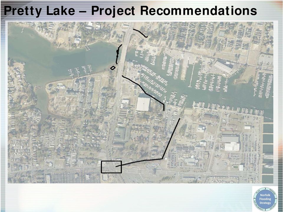
10 Update on Mitigation Studies Fugro Study Final Recommendations Hague Floodwall Preliminary Design Received Estimated Cost $60M Pretty Lake Floodwall Preliminary Design Received Estimated Cost $50M Masons Creek Pump Station Preliminary Design to be completed in 2-3 Weeks Estimated Cost $30M Complimentary Water Quality Analysis. Ohio Creek Implementing Recommendations City Wide Review Analysis of other areas of the City in Progress Tidal flooding Rainfall Flooding

11 The Hague Project Recommendations

12 Pretty Lake Project Recommendations
13 Mason Creek Project Recommendations CAPITAL PROJECT intended to protect against rainfall runoff (Area protected from Tidal Surge by Existing Tide Gate (operated by Navy) will require: Pump station to remove rainfall runoff when gate closed New Storm Culvert beneath Navy OPTIONAL APPROACH Peripheral walls (or berms) where land surface is low around Creek Structure elevation Future building requirements
 where land surface is low around Creek Structure elevation Future")
14 Ohio Creek: Project Recommendations CAPITAL PROJECT Phased as Follows: Phase 1 Acquisition of most vulnerable properties in planning state Phase 2 - Installation of new tidal gate planned for 2012 including capacity for small pump Phase 3 Expansion of existing box culvert or new culvert is proposed for future improvement Booker T. Washington H.S Spartan Village Norfolk State University

15 Citywide Risk Analysis & Flood Mitigation

16 Next Steps for Mitigation Studies Make project reports available to public Coordinate with Army Corps of Engineers and Congressional Delegation for inclusion of Fugro analysis in Federal studies Review environmental requirements Continue Citywide study and analysis of all watersheds

17 Update on Legislative Initiatives The City has undertaken a complete intergovernmental approach to seek assistance and collaboration with all levels of government including: Federal Government Congress Federal Agencies Commonwealth of Virginia General Assembly State Agencies Institutions Universities Local Governments

18 Federal Legislative Initiatives The City initiated efforts to seek Federal assistance through our Congressional Delegation and the U.S. Army Corps of Engineers (USACE). The City coordinated a Citywide tour of flood prone area for Federal representatives. The City hosted community meetings with Representatives Rigell and Scott. In March 2012 the USACE proposed to reprogram $100,000 of Section 205 funding to begin a Reconnaissance Study.

19 Federal Legislative Initiatives (cont d) Next Steps Seek Congressional Authorization & Funding to complete: Reconnaissance study FY13 Feasibility study FY14 Environmental Impact Statement TBD NEPA Coordination - TBD Construction - TBD

20 State Legislative Initiatives At the request of the City of Norfolk the General Assembly approved a joint resolution requesting the Virginia Institute of Marine Science to study strategies for adaptation to prevent recurrent flooding in Tidewater and the Eastern Shore Virginia localities. The study will (i) review and develop a comprehensive list of ideas and examples of strategies used in similar settings around the United States and the world; (ii) convene a stakeholder advisory panel for the purpose of discussing and assessing the feasibility of employing these strategies in Tidewater and Eastern Shore; and (iii) offer specific recommendations for the detailed investigation of preferred options for adapting to relative sea-level rise.
 offer specific recommendations for the")
21 State Legislative Initiatives (cont d) Next Steps Governor signs study resolution March/April 2012 W&M VIMS, in partnership with ODU, commence study in earnest in April W&M VIMS complete Study by January Request that the 2013 General Assembly create and appropriate funding for: A state flood mitigation fund that Virginia Coastal and Shoreline Communities can subscribe to for assistance with federal match share.
22 Summary The City has a comprehensive strategy to address precipitation and tidal flooding. The City has established enhanced communication and collaboration efforts to increase awareness about our flood prone areas. The City has identified specific mitigation projects that will require significant public investment and intergovernmental coordination.
Swannanoa River Flood Risk Management Study
 Swannanoa River Flood Risk Management Study Measures Evaluated to Reduce Future Flood Damages City of Asheville U.S. Army Corps of Engineers Flooding History Part of the 132 square mile Swannanoa River
Flood Risk Management
 Flood Risk Management Value of Flood Risk Management Every year floods sweep through communities across the United States taking lives, destroying property, shutting down businesses, harming the environment
Flood Risk Management
 Flood Risk Management Value of Flood Risk Management Value to Individuals and Communities Every year floods sweep through communities across the United States taking lives, destroying property, shutting
Federal Triangle Stormwater Working Group Federal Triangle Floodproofing Seminar BUILDING STRONG SM
 Federal Triangle Stormwater Working Group Federal Triangle Floodproofing Seminar Initial Risk Flood Risk = Probability of Flooding x Consequences Zoning Building Codes Outreach Evacuation Planning Risk
Flood Emergency Response Planning: How to Protect Your Business from a Natural Disaster RIC005
 Flood Emergency Response Planning: How to Protect Your Business from a Natural Disaster RIC005 Speakers: Tom Chan, CEO, Global Risk Miyamoto Greg Bates, Principal, Global Risk Consultants Learning Objectives
Standard Operating Procedures for Flood Preparation and Response
 Standard Operating Procedures for Flood Preparation and Response General Discussion Hurricanes, tropical storms and intense thunderstorms support a conclusion that more severe flooding conditions than
Lower Raritan Watershed Management Area Stormwater & Flooding Subcommittee Strategy Worksheet LRSW-S3C1
 Strategy Name: Reduce Existing Potential for Flood Damages LRSW-S3C1. Develop and implement a program to: Minimize flood damages through the use of structural measures. Minimize flood damages through the
COMMUNITY CERTIFICATIONS
 National Flood Insurance Program Community Rating System COMMUNITY CERTIFICATIONS Public reporting burden for this form is estimated to average 4 hours for annual recertification, per response. The burden
Section 6: Mitigation Strategy
 Section 6: Mitigation Strategy The Mitigation Strategy section provides the blueprint for the participating jurisdictions in the Unifour Region to follow to become less vulnerable to the negative effects
Section 6: Mitigation Strategy
 Section 6: Mitigation Strategy The Mitigation Strategy section provides the blueprint for the participating jurisdictions in the Eno- Haw Region to follow to become less vulnerable to the negative effects
New Brunswick s Flood Risk Reduction Strategy. Province of New Brunswick PO 6000, Fredericton NB E3B 5H1. www.gnb.ca
 New Brunswick s Flood Risk Reduction Strategy i New Brunswick s Flood Risk Reduction Strategy Province of New Brunswick PO 6000, Fredericton NB E3B 5H1 2014 www.gnb.ca ISBN 978-1-4605-0533-5 (print edition)
5.0 OVERVIEW OF FLOOD DAMAGE REDUCTION MEASURES
 5.0 OVERVIEW OF FLOOD DAMAGE REDUCTION MEASURES Flood damage reduction consists of two basic techniques structural and non-structural. Structural methods modify the flood and take the flood away from people
Flood Damage Mitigation And Insurance Costs
 Flood Damage Mitigation And Insurance Costs Friday, September 25, 2015 at 7:00 PM Saturday, September 26, 2015 at 10:00 AM This presentation was prepared by the Town of South Bethany using Federal Funds
Tools from the US EPA s Climate Ready Water Utilities Initiative (CRWU) EPA Region 3 Conference Extreme Weather Events: Adapt, Mitigate, and Survive
 EPA Region 3 Conference Extreme Weather Events: Adapt, Mitigate, and Survive") Tools from the US EPA s Climate Ready Water Utilities Initiative (CRWU) EPA Region 3 Conference Extreme Weather Events: Adapt, Mitigate, and Survive May 9, 2013 1 Presentation Overview Background on EPA
Tools from the US EPA s Climate Ready Water Utilities Initiative (CRWU) EPA Region 3 Conference Extreme Weather Events: Adapt, Mitigate, and Survive May 9, 2013 1 Presentation Overview Background on EPA
Section 19. Basin-wide Mitigation Action Plans
 Section 19. Basin-wide Mitigation Action Plans This Mitigation Plan identifies twelve specific hazards that could affect the Basin. Section 20 of this Plan set forth mitigation action plans to be carried
Community RiskMAP Questionnaire
 Community RiskMAP Questionnaire Please provide the following information County Date: Community Name/Organization: Your Your E-mail: Contact Preference: E-mail Phone Mail The Federal Emergency Management
The City of Ottawa Flood Hazards
 The City of Ottawa Flood Hazards The City of Ottawa is located in North Central LaSalle County, approximately 45 miles West of Joliet and 90 miles South of Rockford. The primary water course and sources
United States Army Corps of Engineers, Civil Works
 United States Army Corps of Engineers, Civil Works Fiscal Year 2013 Federal Program Inventory May 2013 Table of Contents Introduction... 2 Program Inventory... 3 1. Navigation... 3 2. Flood Risk Management...
Hoboken Resiliency & Readiness Plan
 Hoboken Resiliency & Readiness Plan Layers of Protection Mayor Dawn Zimmer Challenge: Hoboken was once an island outcrop. Surrounding tidal marshes were filled in, but City remains vulnerable to storm
Whole Community Concept Integration into National Disaster Preparedness Training Center University of Hawaii
 Whole Community Concept Integration into National Disaster Preparedness Training Center University of Hawaii Established in 2007 under H.R. 1, Implementing Recommendations of the 9/11 Commission Act of
Develop hazard mitigation policies and programs designed to reduce the impact of natural and human-caused hazards on people and property.
 6.0 Mitigation Strategy Introduction A mitigation strategy provides participating counties and municipalities in the H-GAC planning area with the basis for action. Based on the findings of the Risk Assessment
HAZUS 2014. 7 th Annual Conference
 HAZUS 2014 7 th Annual Conference HAZUS Comparison of Storm Surge Levels from Different Hurricanes to the Newest SLOSH Models for Berkeley, Charleston, & Dorchester Counties Along the SC Coastline. Charlie
ROSE CREEK WATERSHED HYDROLOGIC, HYDRAULIC, SEDIMENT TRANSPORT, AND GEOMORPHIC ANALYSES TASK 1 EXISTING DATA AND INFORMATION SUMMARY REPORT BACKGROUND
 ROSE CREEK WATERSHED HYDROLOGIC, HYDRAULIC, SEDIMENT TRANSPORT, AND GEOMORPHIC ANALYSES TASK 1 EXISTING DATA AND INFORMATION SUMMARY REPORT BACKGROUND The Rose Creek Watershed (RCW) consists of three planning
Oregon. Climate Change Adaptation Framework
 Oregon Climate Change Adaptation Framework Oregon Environmental Quality Commission Climate Change Adaptation Framework Presentation at a glance: Purposes of the framework Participating agencies Climate
Pine Creek Culvert Upgrade $ 560,000. Located at exiting hump dike, just south of Fire Training Center
 To: BOS From: Joseph Michelangelo, P.E. Director of Public Works Re: CDBG-DR Pine Creek Culvert Upgrade Date: April 20, 2015 On June 19, 2014, the Town of Fairfield was awarded the above referenced project
New Orleans Hurricane Storm Damage Risk Reduction System Tour March 23 24, 2012
 New Orleans Hurricane Storm Damage Risk Reduction System Tour March 23 24, 2012 Host: Falcolm E. Hull, Vice President/Technical Expert, ARCADIS, U.S. Inc. Attending: Cherie Coffman, Coastal Projection
Adaptation for City Infrastructure; A Case Study of East Boston, MA
 Adaptation for City Infrastructure; A Case Study of East Boston, MA Paul Kirshen and Thomas Ballestero with support from Kirk Bosma, Wood Hole Group EMF, July 22, 2014 Funded by SARP, OGP, US NOAA Climate
New York Sea Grant Strategic Plan
 New York Sea Grant Strategic Plan Introduction and Process This is the new strategic plan for New York Sea Grant (NYSG) for the years 2010-2013 as requested by the National Sea Grant Office. This plan
CDM. City of Jacksonville Master Stormwater Management Plan (MSMP) Update. December 2008 Update. Agenda. 1. Data Collection. 2.
 Update. December 2008 Update. Agenda. 1. Data Collection. 2.") City of Jacksonville Master Stormwater Management Plan (MSMP) Update December 2008 Update CDM Agenda 1. Data Collection 1. GIS/LiDAR 2. Survey 2. Water Quantity 1. SWMM Modeling 2. FEMA 3. Water Quality
City of Jacksonville Master Stormwater Management Plan (MSMP) Update December 2008 Update CDM Agenda 1. Data Collection 1. GIS/LiDAR 2. Survey 2. Water Quantity 1. SWMM Modeling 2. FEMA 3. Water Quality
City of Cambridge Climate Protection Action Committee. Recommendations for Adaptation to Climate Change. Purpose
 City of Cambridge Climate Protection Action Committee Recommendations for Adaptation to Climate Change Purpose The Climate Protection Action Committee (CPAC) is an advisory body to the City Manager on
DEPARTMENT OF THE ARMY OFFICE OF THE CHIEF OF ENGINEERS WASHINGTON, D.C. 20314-1000
 DEPARTMENT OF THE ARMY OFFICE OF THE CHIEF OF ENGINEERS WASHINGTON, D.C. 20314-1000 CEMP-SPD (l105-2-10a) APR 1 5 2012 THE SECRETARY OF THE ARMY 1. I submit for transmission to Congress my report on coastal
Floodplain 8-Step Process in accordance with Executive Order 11988: Floodplain Management. New Jersey Department of Environmental Protection
 Floodplain 8-Step Process in accordance with Executive Order 11988: Floodplain Management New Jersey Department of Environmental Protection U.S. Department of Housing and Urban Development Community Development
ECONOMIC ANALYSIS FLOOD DAMAGE REDUCTION. Lower Carmel River Floodplain Restoration and Enhancement Project
 ECONOMIC ANALYSIS FLOOD DAMAGE REDUCTION Lower Carmel River Floodplain Restoration and Enhancement Project I. Description of the Project and its Relationship to Other Projects in the Proposal The Lower
United States Postal Service Climate Change Adaptation Plan
 United States Postal Service Climate Change Adaptation Plan Version: June 29, 2012 USPS Climate Change Adaptation Plan 1. Introduction...2 2. Policy Framework...3 Vision & Goals...3 Objectives...3 Responsible
New Coastal Study for Puerto Rico FIRMs. Paul Weberg, FEMA RII Mat Mampara, Dewberry Jeff Gangai, Dewberry Krista Collier, Baker
 New Coastal Study for Puerto Rico FIRMs Paul Weberg, FEMA RII Mat Mampara, Dewberry Jeff Gangai, Dewberry Krista Collier, Baker September 2007 Project Team FEMA Region II Program Manager Collaboration
Climate Change Long Term Trends and their Implications for Emergency Management August 2011
 Climate Change Long Term Trends and their Implications for Emergency Management August 2011 Overview A significant amount of existing research indicates that the world s climate is changing. Emergency
Overview. Homeowner Flood Insurance Affordability Act
 Homeowner Flood Insurance Affordability Act Overview On March 21, 2014, President Obama signed the Homeowner Flood Insurance Affordability Act of 2014 into law. This law repeals and modifies certain provisions
ARkStorm: California s Other Big One!
 ARkStorm: California s Other Big One! Understanding the Impacts of Massive Winter Storms Mark Jackson Meteorologist in Charge NOAA/National Weather Service Los Angeles/Oxnard What is ARkStorm? Emergency-preparedness
Emergency Support Function #14 Long Term Community Recovery and Mitigation
 Emergency Support Function #14 Long Term Community Recovery and Mitigation Primary Agency FEMA Board of Visitors Radford University Cabinet Secondary/Support Agencies Radford University Office of Emergency
FLOOD INFORMATION SERVICE EXPLANATORY NOTES
 FLOOD INFORMATION SERVICE EXPLANATORY NOTES Part 1 About the flood maps Limitations of the mapping What the maps don t show Where to find more information Definitions of words used to describe flooding.
Federal Emergency Management Agency (FEMA) Preliminary Flood Insurance Rate Maps (FIRMs) and Preliminary Flood Insurance Study (FIS) for New York City
 Preliminary Flood Insurance Rate Maps (FIRMs) and Preliminary Flood Insurance Study (FIS) for New York City") March 10, 2014 Submitted electronically via http://www.nyc.gov Mayor s Office of Long Term Planning and Sustainability c/o Flood Map Comments 253 Broadway, 10th Floor New York, NY 10007 Federal Emergency
March 10, 2014 Submitted electronically via http://www.nyc.gov Mayor s Office of Long Term Planning and Sustainability c/o Flood Map Comments 253 Broadway, 10th Floor New York, NY 10007 Federal Emergency
North San Jose Neighborhoods Planning Taskforce
 North San Jose Neighborhoods Planning Taskforce Key Topics Water Supply Flooding Related Topics Storm Water Storm Sewer Sanitary Sewer Water Conservation Treatment Plant Water Background Responsible Agencies
June 16, 2015 PURPOSE
 June 16, 2015 BACKGROUND MEMO TO: FROM: RE: Members, Subcommittee on Economic Development, Public Buildings, and Emergency Management Staff, Subcommittee on Economic Development, Public Buildings, and
U.S. Army Corps of Engineers
 Walla Walla District U.S. Army Corps of Engineers Hurricane Katrina Response Briefer: Joseph Saxon Today s Briefing U.S. Army Corps of Engineers Mission Events leading up to New Orleans flooding Corp s
Town of Chatham Department of Community Development
 Town of Chatham Department of Community Development TOWN ANNEX 261 GEORGE RYDER ROAD 02633 CHATHAM, MA TELEPHONE (508) 945-5168 FAX (508) 945-5163 FEMA FLOOD MAP UPDATE & PROPOSED ZONING BYLAW AMENDMENT
US Army Corps of Engineers Authorities and Programs
 US Army Corps of Engineers Authorities and Programs Section 206; Flood Plain Management Services Program Section 22; Planning assistance to States General Investigations (large-scale flood risk reduction)
NOAA COASTAL SERVICES CENTER Strategic Plan: 2010 to 2015
 NOAA COASTAL SERVICES CENTER Strategic Plan: 2010 to 2015 N a t i o n a l O c e a n i c a n d A t m o s p h e r i c A d m i n i s t r a t i o n ( N O A A ) C o a s t a l S e r v i c e s C e n t e r March
Post-Sandy Municipal Needs Assessment for Long-Term Recovery and Resiliency Planning EXECUTIVE SUMMARY
 Post-Sandy Municipal Needs Assessment for Long-Term Recovery and Resiliency Planning EXECUTIVE SUMMARY Prepared by Nathaly Agosto Filión, Resiliency Manager for the New Jersey Resiliency Network, a program
Predicting Coastal Hazards: A Southern California Demonstration
 Predicting Coastal Hazards: A Southern California Demonstration Patrick Barnard United States Geological Survey Coastal and Marine Geology Team Santa Cruz, CA Southern California Multi-hazards Demonstration
Eastern Connecticut Risk & Vulnerability Assessment Workshop
 Coastal Resilience New York and Connecticut A Tool for Coastal Planning in a Changing World Eastern Connecticut Risk & Vulnerability Assessment Workshop January 11, 2012 Waterford Town Hall - Auditorium
NAPA COUNTY WATERSHED SYMPOSIUM
 Planning, Building, and Environmental Services NAPA VALLEY GROWTH NAPA COUNTY WATERSHED SYMPOSIUM Plunging Forward May 15, 2015 1 YOU CAN T CROSS THE SEA MERELY BY STANDING AND STARING AT THE WATER. Rabindranath
(Adopted July 26, 2005 Resolution No. 05-24) Prepared by: Kevin Marstall, PE, Senior Civil Engineer, CRS Coordinator
 Prepared by: Kevin Marstall, PE, Senior Civil Engineer, CRS Coordinator") On The Floodplain Management Components Of The Association of Bay Area Governments (ABAG) Multi-Jurisdictional Hazard Mitigation Plan Including The Annex to the Plan as the City s Local Hazard Mitigation
On The Floodplain Management Components Of The Association of Bay Area Governments (ABAG) Multi-Jurisdictional Hazard Mitigation Plan Including The Annex to the Plan as the City s Local Hazard Mitigation
Appendix F Benefit-Cost Analysis of Flood Protection Measures
 Appendix F Benefit-Cost Analysis of Flood Protection Measures Acronyms used in Appendix F: AA B AA C AA D BC BFE EAD FEMA NED O&M PV RED USACE Average Annual Benefits Average Annual Cost Average Annual
Mariana Leckner, Ph.D., Professor, American Military University Thomas O. Herrington, Ph.D. Associate Professor, Stevens Institute of Technology
 Mariana Leckner, Ph.D., Professor, American Military University Thomas O. Herrington, Ph.D. Associate Professor, Stevens Institute of Technology National Hydrologic Warning Council Training Conference
Melbourne Water Flood Risk Assessment: How flood impacts are assessed in the Port Phillip and Westernport region
 Melbourne Water Flood Risk Assessment: How flood impacts are assessed in the Port Phillip and Westernport region INTRODUCTION Melbourne Water is the regional drainage and floodplain management authority
Overview of Singapore s Drainage Management Approach July 2011
 Overview of Singapore s Drainage Management Approach July 2011 1 Background Singapore is a small Island surrounded by the sea and therefore drainage is affected by tidal conditions. Singapore also has
This paper provides a concise description of
 13 UNIVERSITIES COUNCIL ON WATER RESOURCES ISSUE 130, PAGES 13-19, MARCH 2005 Overview of Flood Damages Prevented by U.S. Army Corps of Engineers Flood Control Reduction Programs and Activities James J.
City of London Climate Change Adaptation Strategy Dealing with Extreme Rainfall Events
 City of London Climate Change Adaptation Strategy Dealing with Extreme Rainfall Events May 29, 2014 Presented by: Berta Krichker M.Eng., FEC, P.Eng. Manager of Stormwater Unit Environmental and Engineering
Flood Insurance Repetitive Loss Property
 Flood Insurance Repetitive Loss Property When our system of canals, ditches and culverts was built over 20 years ago, it could handle all but the largest tropical storms and hurricanes; since then, urban
Presented by: Michael DePue, PE, CFM Annual Georgia Association of Floodplain Management Conference Lake Lanier Islands, Georgia March 23, 2010
 Flood Types and Characteristics Presented by: Michael DePue, PE, CFM Annual Georgia Association of Floodplain Management Conference Lake Lanier Islands, Georgia March 23, 2010 Agenda Why study flood types?
Association of State Flood Managers Annual Conference Wednesday, June 4, 2014
 Association of State Flood Managers Annual Conference Wednesday, June 4, 2014 Hillsborough County, In the Trenches Local Mitigation Eugene Henry, CFM, AICP Hazard Mitigation Manager Floodplain Administrator
Disaster Recovery Managing and Leveraging Multiple Funding Sources
 Disaster Recovery Managing and Leveraging Multiple Funding Sources Jordan Williams, CFM June 3, 2015 Overview Programs FEMA Public Assistance (PA) and Hazard Mitigation Grant Program HUD s Community Development
Table of Contents ESF-3-1 034-00-13
 Table of Contents Primary Coordinating Agency... 2 Local Supporting Agencies... 2 State, Regional, and Federal Agencies and Organizations... 3 Purpose... 3 Situations and Assumptions... 4 Direction and
SECTION 3.2 CLIMATE AND PRECIPITATION
 SECTION 3.2 CLIMATE AND PRECIPITATION Ulster County Climate Data A preliminary analysis of the Preserve s weather data shows that the average temperature has risen about two degrees over the past 114 years.
4.14 Netherlands. Interactive flood risk map of a part of the province of Gelderland in the Netherlands. Atlas of Flood Maps
 4.14 Netherlands The Netherlands is flood prone for about 60% of its surface. 95 so-called dike-rings protect the polders from being flooded from the North Sea, rivers or lakes. The protection level has
CHAPTER 7. EMERGENCY SERVICES
 CHAPTER 7. EMERGENCY SERVICES Although better forecasts and warning processes have helped save lives by providing more lead time to evacuate, the tremendous growth of development and human population in
Using LIDAR to monitor beach changes: Goochs Beach, Kennebunk, Maine
 Geologic Site of the Month February, 2010 Using LIDAR to monitor beach changes: Goochs Beach, Kennebunk, Maine 43 o 20 51.31 N, 70 o 28 54.18 W Text by Peter Slovinsky, Department of Agriculture, Conservation
2015 -- H 5478 S T A T E O F R H O D E I S L A N D
 LC00 01 -- H S T A T E O F R H O D E I S L A N D IN GENERAL ASSEMBLY JANUARY SESSION, A.D. 01 H O U S E R E S O L U T I O N CREATING THE RHODE ISLAND HOUSE COMMISSION ON ECONOMIC RISK DUE TO FLOODING AND
Muddy River Restoration Project Maintenance and Management Oversight Committee 68 Harvard Street Brookline, Massachusetts 02447 www.muddyrivermmoc.
 Muddy River Restoration Project Maintenance and Management Oversight Committee 68 Harvard Street Brookline, Massachusetts 02447 www.muddyrivermmoc.org FEDERAL FUNDING OF ENVIRONMENTAL RESTORATION IN PHASE
Malcolm L. Spaulding Professor Emeritus, Ocean Engineering University of Rhode Island Narragansett, RI 02881
 Malcolm L. Spaulding Professor Emeritus, Ocean Engineering University of Rhode Island Narragansett, RI 02881 USACE Coastal and Hydraulics Laboratory(CHL) Data Infrastructure Workshop January 23, 2014 Overview
FLOOD HAZARD IN THE URBAN ENVIRONMENT: IMPLICATIONS FOR DEVELOPERS, DESIGNERS, AND ATTORNEYS
 FLOOD HAZARD IN THE URBAN ENVIRONMENT: IMPLICATIONS FOR DEVELOPERS, DESIGNERS, AND ATTORNEYS PRESENTED BY: CHAD W. COX, P.E. DANIEL C. STAPLETON, P.E. BOSTON, MA JAN. 24, 2014 PRESENTATION Flood Vulnerability
Chapter 6: Mitigation Strategies
 Chapter 6: Mitigation Strategies This section of the Plan describes the most challenging part of any such planning effort the development of a Mitigation Strategy. It is a process of: 1. Setting mitigation