Post-fire Recovery and Restoration: Soils, Runoff and Erosion
|
|
|
- Earl Rose
- 10 years ago
- Views:
Transcription
1 Post-fire Recovery and Restoration: Soils, Runoff and Erosion Lee H. MacDonald Watershed Science Program Dept. of Ecosystem Science and Sustainability Colorado State University

2 Objectives 1. Provide a process-based summary of how fires in the Colorado Front Range affect soils, runoff, and erosion: At different spatial scales; Recovery over time; 2. Present data and observations from the High Park fire; 3. Use this knowledge and understanding to predict future recovery and potential for rehabilitation.

3

4 Post-fire Hydrology
5 Post-fire Hydrology Loss of vegetative canopy and surface cover; Shift in runoff processes from sub-surface stormflow to infiltration-excess (Horton) overland flow; LARGE increases in peak flows and erosion rates; Downstream sedimentation; Degradation in water quality (turbidity, suspended sediment, nitrate, manganese, dissolved organic carbon), and aquatic habitat. What are the primary causes of post-fire runoff and erosion, and what can we do to reduce them?
, and aquatic habitat.")


6 40 O N Lower Flowers Hourglass Big Elk Dadd Bennett Hewlett Gulch Bobcat Crosier Mt. Bear Tracks Denver Hayman Schoonover 4 O Study sites in the Colorado Front Range

7 Contributors Tedd Huffman (M.S., 2002); Juan Benavides-Solorio (Ph.D., 2003); Joe Wagenbrenner (M.S., 2003); Matt Kunze (M.S., 2003); Zamir Libohova (M.S., 2004); Jay Pietraszek (M.S., 2006); Daniella Rough (M.S., 2007); Duncan Eccleston (M.S., 2008); Keelin Schaffrath (M.S., 2009); Ethan Brown (M.S., 2009); Darren Hughes (M.S., 2010?); Dr. John Stednick; Isaac Larsen (Research assistant, ); Sergio Alegre (Visiting Ph.D. student, 2010).
; Sergio Alegre (Visiting Ph.D. student, 2010).")
8 More students to do the hard work: Sarah Schmeer (Watershed) and Dan Brogran (Civil Engineering) Thanks to private landowners who allow access!

9 Key Observations about the High Park Fire Relatively small area burned at high severity;


10 Fire severity map (CSU version) Gordon Creek Cache la Poudre River Poudre Park Hill Gulch Skin Gulch Bennett Creek Lewstone Creek Lewstone Creek Pendergrass Creek Redstone Creek Redstone Creek Laurence Creek Stove Prairie Creek

11 Key Observations about the High Park Fire This patchiness relatively typical; Amount and distribution of burn severity has important implications for runoff, erosion, and delivery to the Poudre River;

12 Key Observations about the High Park Fire Burned relatively long and late, as only contained on 1 July; First major storm occurred on 6 July, so little opportunity to collect baseline (pre-storm) data; Relatively wet July led to lots of runoff and erosion; Second largest fire in Colorado history, plus proximity to CSU, led to an interdisciplinary research proposal;

13 RAPID Grant from NSF Detailed imagery and topography of the burned area; Physical science component: Sediment fences to measure hillslope-scale sediment production; Channel cross-sections and longitudinal profiles to track incision and deposition; Use measured sediment production rates and detailed imagery to predict watershed-scale sediment production; Use channel data to roughly estimate the proportion of sediment being delivered to the Cache la Poudre River; Now have about 20 sediment fences and 8 rain gages installed, but relatively dry August!

14 Hillslope component

15 Newly-installed sediment fence to measure sediment production

16 Later that afternoon in a rainstorm...

17 600 kg of sediment from 0.75 inches of rain!

18 At Hill Gulch in a storm...

19 And downstream at Highway 14

20 Using high water marks to estimate peak flows

21 Threat of yet another flood!
22 At Skin Gulch, a 7-ft culvert no longer big enough.
23 Flow across Highway 14 and into the Poudre
24 Cross-section at Skin Gulch, pre-flood
25 Accumulation of woody debris and sediment, Skin Gulch cross-section
26 Cross-section 100 m upstream over time Skin Gulch at Stove Prairie and Highway Z (m ) 1 7/4/2012 7/22/2012 8/5/ Distance (m)
27 Channel cross-section change
28
29 Key Observations about the High Park Fire Very large increase in peak flows; Undersized culverts at risk, particularly on private roads; Large amounts of sediment deposited in main channels; Believe that most of the sediment is NOT reaching the Poudre River; Ash and fine sediment deposited in the Poudre River, primarily along channel margins;
30 Implications Relatively low amounts of high severity and a wet July has led to rapid regrowth; Riparian areas; Shrublands; Most sites burned at moderate severity;
31 Sediment yield vs. percent bare soil Sediment yield (Mg ha -1 yr -1 ) y = e 0.095x p < R 2 = 0.61 n= Percent bare soil
32 Percent bare soil vs. time since burning 100 High severity y = Ln(x) Percent bare soil Moderate severity Low severity R 2 = 0.63 y = Ln(x) R 2 = 0.60 y = Ln(x) R 2 = Time since burning (years)
33 Annual sediment yields vs. time since burning: High severity sites 40.0 Sediment yield (Mg ha -1 ) Big Elk Hayman Schoonover Hewlett Gulch Bobcat Lower Flowers Crosier Mountain Bear Tracks Hourglass Median value Time since burning (years)
34 Hierarchy of controls on post-fire runoff and erosion Percent ground cover; Rainfall intensity (8-10 mm/hr sufficient to generate surface runoff and erosion); Soil: Moisture; Water repellency; Soil type.
35 Predictions: Now to summer 2013 Relatively rapid regrowth in shrublands and areas burned at moderate severity; Nearly at the end of the summer thunderstorm season, so probably will not see flooding like we saw in July (whew!); Fall rains and winter-spring snowmelt should?
36 Predictions Fall rains and winter-spring snowmelt should: Not cause any significant hillslope erosion; May cause some continuing channel incision in areas that have large sediment deposits, but most of this will still not reach the Poudre River; Mobilize much of the ash and fine sediment that is currently stored along the channel margins in the Poudre River and transport it further downstream;
37 Predictions: Summer 2013? Most of the ash and readily available fine sediment has already washed off the slopes and been delivered to the Poudre River, so next summer the water will not be nearly as black; Hillslope erosion rates, given similar rainfall events, will be much less due to the reduction in percent bare soil; Tributary channels will continue to incise and slowly stabilize;
38 Recovery: What to do? Selective mulching can help in summer 2013: Focus on high severity areas that still have relatively little regrowth; Even less of the sediment generated from the hillslopes and channels will reach the Poudre River; Focus on those tributaries that burned at high severity in their lower sections; Poudre River should slowly clean itself;
39 Recovery: What to do? Consider planting trees in the areas where natural seeding is unlikely; Litter is arguably the most important source of ground cover, particularly in poorer sites that cannot support a dense ground cover; Big problem with invasive species in some areas;

40 Good cover, but all leafy spurge (Hill Gulch)
41 Recovery: What to do? If we get an extreme storm event, all these predictions go out the window! In Hill Gulch, the 1976 Big Thompson storm has had a larger effect on the channels than the High Park fire.
42 More information Type Lee MacDonald into google, and look at the publications on my web site; 2008 Stream Notes provides a nice readable summary;
43 Predictions Relatively rapid regrowth in shrublands and areas burned at moderate severity; Winter rains and snowmelt will: Not cause any significant hillslope erosion;
44 Sediment vs. I 30 : Recently burned, high severity wildfires 10-1 ) Mean sediment production (Mg ha minute maximum intensity (mm hr -1 )
45 Predictions Relatively rapid regrowth in shrublands and areas burned at moderate severity; Winter rains and snowmelt will: Not cause any significant hillslope erosion; ; Why is this important?
46 Collecting Data at Different Spatial Scales Point scale: soil water repellency; Small plot scale (1 m 2 ): Runoff and sediment yields from rainfall simulations; Hillslope scale (0.01 to 1 ha): Sediment production from planar hillslopes and swales (zero-order catchments) using sediment fences; Using replicated hillslopes (swales) to compare different rehabilitation methods against untreated controls; Small catchment scale (0.04 to 6 km 2 ): Measuring runoff, suspended sediment yields, water quality, and channel morphology.
47
48 Our cover data
49 Event-based sediment production vs. I 30 : High-severity wildfires Mean sediment production (Mg ha -1 ) years after burning 4-5 years after burning R 2 = 0.50 R 2 = minute maximum intensity (mm hr -1 )
50 Mean sediment yields on control and mulched plots: Bobcat fire, Sediment yield (Mg ha -1 ) * * * * Control Old mulch New mulch * = Significant treatment effect (p<0.05)
51 Sediment yields for controls and straw mulch 20 with seeding: Hayman fire, Sediment yield (Mg ha -1 ) * * Control Straw mulch with seeding * = Significant treatment effect (p<0.05)
52 Sediment yields by fire severity and season: First two years after burning 10.0 Sediment yield (Mg ha -1 ) Summer Rainfall (Jun-Oct) Snowmelt (Nov-May) 0.0 High Moderate Low Fire severity
53 Hayman Fire, Colorado: August 2004
54 Alluvial fan from Saloon Gulch extending into the South Platte River, summer 2004 (two years after the 2002 Hayman fire)
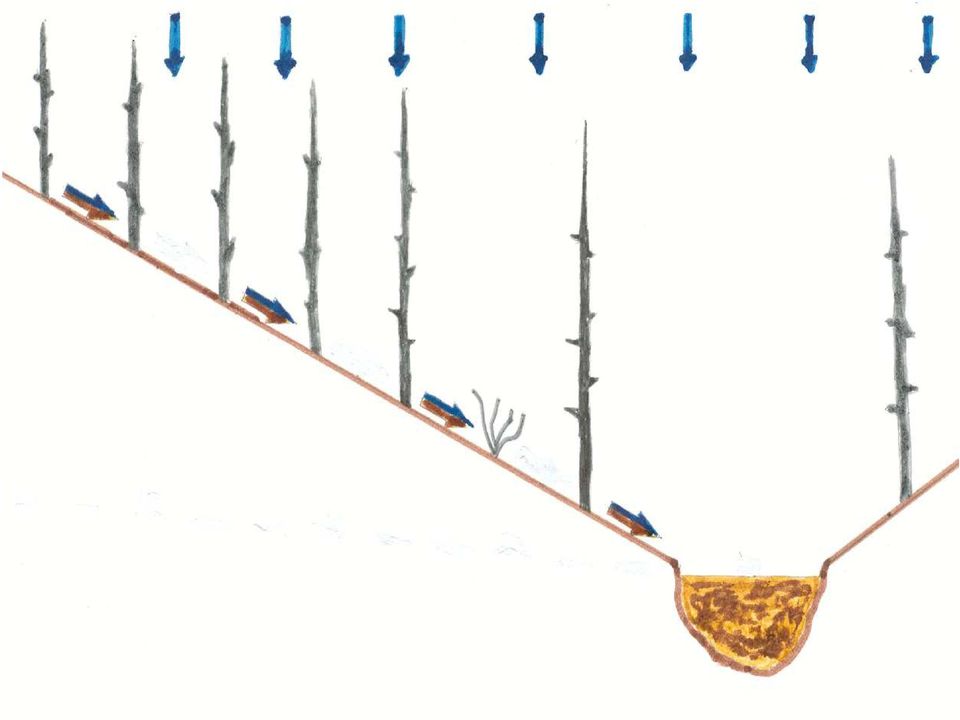
55 Causes of Post-fire Runoff and Erosion Soil water repellency Loss of surface cover Loss of organic matter Loss of plant canopy Reduced roughness Increased velocity Soil sealing Rainsplash Increased soil erodibility Reduced Interception and transpiraton Increased runoff (peak flows, water yield) Increased surface erosion (rainsplash, sheetwash, rilling, gullying)
56 Area Burned and Precipitation, Km2 burned Annual precipitation 70 Historic mean precipitation Wildfire (km 2 ) Annual precipitation (cm) Years Climate change can greatly affect the amount and severity of future wildfires!


57 Soil Water Repellency
58 Soil water repellency over time: Bobcat fire 80 a) 0 mo (n = 45 at each depth) 80 b) 3 mo (n = 45 at each depth) Critical surface tension (dynes cm -1 ) Unburned 50 Low severity 40 Moderate severity High severity Depth (cm) Critical surface tension (dynes cm -1 ) Unburned Low severity Moderate severity High severity Depth (cm) Critical surface tension (dynes cm -1 ) c) 12 mo (n = 45 at each depth) Unburned Low severity Moderate severity High severity Depth (cm) MacDonald and Huffman, 2004
59 Spatial variability in soil water repellency: Plot H1, high severity, Hayman fire 14 Meters Moles of ethanol per liter Meters Woods et al. 2007, Geomorphology
60 Summary: Soil Water Repellency Surface in unburned areas naturally water repellent, but less subsurface water repellency; Fire-induced water repellency is usually shallow (maximum of 9 cm); Usually strongest in high and moderate severity fires; May be stronger in prescribed fires due to higher fuel loadings and slower rate of fire spread; Very high spatial variability; Relatively rapid recovery ( 2 years); Not present under wet conditions (~10-35 percent soil moisture), depending on fire severity; CST faster and more consistent than WDPT.
61 Year 2000, 15 days after fire 96% Bare soil Vegetation recovery over time Bobcat fire, sediment fence #9 Year % Bare soil Year % Bare soil Year % Bare soil
62 Rainfall erosivity versus mean sediment yields: Five storms on three areas, Hayman fire, Rainfall erosivity (MJ mm ha -1 h -1 ) Sediment yield Mg ha -1 ) Jun Jun Jul Aug-03 6-Sep-03 USG South (n=3) USG North (n=8) USG East (n=5)
63 Slower recovery on high-severity sites, Hayman-Schoonover wildfires 20 Mean sediment production (Mg ha -1 ) Time since burning (years)
64 Upper Saloon Gulch: 10 July mm rain in 2 hours
65 Sediment yields from swales vs. planar hillslopes in 2001: Bobcat fire Sediment production (kg m -2 ) Erosivity (MJ mm ha -1 h -1 ) Planar hillslopes 2001 Swales 2001 R 2 = 0.57 p = 0.01 R 2 = 0.53 p = 0.007
66 Treatments after the Hayman fire: Scarifying and seeding; 2. Straw mulching with seed; 3. Hydromulching Ground based; Aerial; 4. Polyacrylamide (soil binding agent).
67 Seeding
68 Percent surface cover for controls and seeding: Bobcat fire, Percent Cover Fall 2000 Spring 2001 Fall 2001 Spring Fall 2002 Spring 2003 Fall 2003 Control Seeding No significant treatment effect
69 Sediment yields for controls and seeding: Bobcat fire, Sediment yield (Mg ha -1 ) Control Seeding No significant treatment effect
70 Mulching
71 Video Clip: Mulching
72 Percent surface cover on control and mulched plots: Bobcat fire, Percent Cover * * * * * * * * * Fall 2000 Spring 2001 Fall 2001 Spring Fall 2002 Control Old mulch New mulch Spring 2003 Fall 2003 * = Significant treatment effect (p<0.05)
73 Runoff and sediment yields from rainfall simulations on control and straw mulch plots: Hayman fire, 2003 Runoff / Rainfall Ratio Sediment Yield Runoff / rainfall ratio (%) % mean 45% mean Sediment production (g/hr) g mean 86 g mean Controls Dry Mulch Controls Dry Mulch
74 Intensity threshold: Raked swales 15-1 ) Mean sediment production (Mg ha minute maximum intensity (mm hr -1 )
75 Event-based sediment production vs. I 30 : Burned and raked swales 15 Mean sediment production (Mg ha -1 ) Burned swales Raked swales minute maximum intensity (mm hr -1 )
76 Causes of Post-fire Runoff and Erosion Soil water repellency Loss of surface cover Loss of organic matter Loss of plant canopy Reduced roughness Increased velocity Soil sealing Rainsplash Increased soil erodibility Reduced Interception and transpiraton Increased runoff (peak flows, water yield) Increased surface erosion (rainsplash, sheetwash, rilling, gullying)
77 Lessons for Future Studies High variability between sites necessitates replication; Replication at plot and hillslope scale feasible, while replication at the catchment scale is costly and sites are difficult to find and replicate; One can never have too many rain gages, as the variability in rainfall can easily confound the results; Detailed site measurements are needed to interpret and explain the results (how do you understand the processes if you only measure the outputs?); Few studies are lucky enough to capture the largest storm events that may be of most interest, so the effects of these events have the greatest uncertainty.
78 Conclusions (1) High-severity wildfires increase runoff and sediment production rates by several orders of magnitude; Sediment production rates from high-severity sites are nearly an order of magnitude higher than sites burned at moderate or low severity; Sediment production rates are highest in the first two summers after burning, and rapidly decline to near-background levels except in sites with exceptionally coarse soils with poor growing conditions;
79 Conclusions (2) Percent ground cover is the most important control on post-fire erosion rates; Rainfall erosivity, topographic convergence, and soil texture are secondary controls on post-fire erosion; Rill erosion in convergent areas is the dominant erosion process rather than sheetwash on hillslopes; Soil water repellency is too short-lived to account for the observed increases in sediment production; We believe that soil sealing on bare soil is the primary cause of high post-fire runoff and erosion rates;
80 Conclusions (3) Erosion prediction models are not very accurate for individual sites, but can provide a first-order estimate of average sediment yields; Seeding and scarification do not increase ground cover or reduce erosion rates. Mulching is the most effective post-fire rehabilitation technique because it immediately provides ground cover and prevents soil sealing, but does not increase regrowth rates; Large amounts of sediment are deposited in downstream areas, and downstream channels are likely to take decades or even centuries to recover to pre-fire conditions.
81 Even more information.... Numerous papers on my web site (type Lee MacDonald, Colorado into google).
82 Questions?
 Mean critical surface tension (dynes cm -1")
83 Soil water repellency and sediment yields Mean sediment yield (Mg ha -1 ) over time: Hayman fire 12 Sediment yield 0 Soil water repellency at 0 cm 10 No water repellency Time since burning (years) Mean critical surface tension (dynes cm -1 )
84 Scale effects: How do post-fire sediment yields vary with contributing area?
85 Sediment yield versus contributing area for convergent hillslopes and watersheds: Hayman and Schoonover fires 100 Sediment yield (Mg ha Year 2 Year 3 Year 4 p=0.72 p=0.49 p= Contributing area (m 2 )
86 Sediment yield versus contributing area for convergent hillslopes: Bobcat fire Sediment yield (Mg ha ) Year 2 Year 3 Year 4 p< p=0.07 p< Contributing area (m 2 )
87 Contributing area versus sediment yield Sediment yield (Mg ha -1, Mg ha -1 yr -1, Mg ha -1 h -1 ) R 2 = Spain: High severity 0.01 Spain: Low severity US: High severity US: Moderate severity US: Low severity Best fit line E+07 1E+08 1E+09 Contributing area (m 2 )
88 Percent bare soil on control and mulched plots: Bobcat fire, Percent bare soil Fall 2000 Spring 2001 Fall 2001 Spring 2002 Fall 2002 Spring 2003 Fall 2003 Control Old Mulch New Mulch
89 Mean sediment yields on control and mulched plots: Bobcat fire, Sediment yield (kg ha -1 ) Control Old Mulch New Mulch
90 Questions?
91 Sediment yield versus contributing area for planar 100 hillslopes: Hayman fire 10 Sediment yield (Mg ha -1 ) p=0.04 p=0.05 p<0.01 Year 2 Year 3 Year Contributing area (m 2 )
92 Sediment yield versus contributing area for planar hillslopes: Bobcat fire Sediment yield (Mg ha ) p<0.01 p<0.01 p=0.5 Year 2 Year 3 Year Contributing area (m 2 )
93 Sediment yield versus contributing area for mulched convergent hillslopes and watersheds: Hayman fire ) 10 Sediment yield (Mg ha Year 2 Year 3 p=0.6 p=0.5 Year Contributing area (m 2 ) p=0.06
94 Mean sediment production by fire severity 2500 and year: Bobcat Fire Sediment yield (g) High Moderate Low / Unburned Fire severity
95 Sediment yields from unburned plots and burned untreated plots, Hayman fire Sediment yield (g) Unburned 2003 burned untreated 2004 burned untreated
96 Sediment yield vs. percent bare soil for rainfall simulations, Bobcat Fire 3000 Sediment yield (g) High severity Moderate severity Low severity/unburned R 2 = 0.72 p < % 20% 40% 60% 80% 100% Bare soil
97 Percent bare soil and sediment yields for three areas in the Bobcat Fire (all high severity; bars indicate one standard deviation) 100 a Percent bare soil Sediment yield (Mg ha -1 ) Bobcat Gulch Jug Gulch Green Ridge 0 Bobcat Gulch Jug Gulch Green Ridge
98 Hydrology of Unburned Forests Typically coarser-textured soils (loam, or sandy loam); Generally good ground cover (usually 80%); Storm runoff generated primarily by subsurface stormflow; Low peak flows from all but highest-magnitude storm events; Very low mean erosion rates (<0.1 t ha -1 yr -1 ); Clean, high quality water.
99 Cross-section slightly upstream
Prepared By: Tom Parker Geum Environmental Consulting, Inc.
 Prepared By: Tom Parker Geum Environmental Consulting, Inc. Topics covered: Definition of riparian and floodplain restoration Floodplain attributes as a basis for developing criteria for restoration designs
Colorado Natural Heritage Program
 CNHP s mission is to preserve the natural diversity of life by contributing the essential scientific foundation that leads to lasting conservation of Colorado's biological wealth. Colorado Natural Heritage
Waldo Canyon Fire. Mark Shea Watershed Planning Supervisor August 23, 2012
 Mark Shea Watershed Planning Supervisor August 23, 2012 Fire Started: Saturday June 23, 2012 Fire Progression June 23 2500 acres June 24 3600 acres June 25 4500 acres June 26 15622 acres June 27-28
How To Assess An Area For Erosion
 SKY BASIN (UPPER CA 1 WATERSHED) EROSION ASSESSMENT Prepared by Kevin Drake, CPESC Integrated Environmental Restoration Services, Inc. August 2014 COMMON GROUND UNCOMMON SOLUTIONS P.O. BOX 7559 2780 LAKE
Prattsville Berm Removal Project. 1.0 Project Location
 Prattsville Berm Removal Project 1.0 Project Location The project site is located between the New York State Route 23 Bridge over the Schoharie Creek and the Schoharie Reservoir. The restoration plan encompassed
Flash Flood Science. Chapter 2. What Is in This Chapter? Flash Flood Processes
 Chapter 2 Flash Flood Science A flash flood is generally defined as a rapid onset flood of short duration with a relatively high peak discharge (World Meteorological Organization). The American Meteorological
Post-Wildfire Clean-Up and Response in Houston Toad Habitat Best Management Practices
 Post-Wildfire Clean-Up and Response in Houston Toad Habitat Best Management Practices Purpose The purpose of this document is to provide guidance and recommendations for minimizing potential impacts to
1.7.0 Floodplain Modification Criteria
 1.7.0 Floodplain Modification Criteria 1.7.1 Introduction These guidelines set out standards for evaluating and processing proposed modifications of the 100- year floodplain with the following objectives:
Healthy Forests Resilient Water Supply Vibrant Economy. Ecological Restoration Institute
 Healthy Forests Resilient Water Supply Vibrant Economy Ecological Restoration Institute How Water Gets to Your Home MOST OF THE VALLEY S WATER SUPPLY comes from winter precipitation and runoff from Arizona
WEPP MODEL APPLICATIONS FOR EVALUATIONS OF BEST MANAGEMENT PRACTICES
 WEPP MODEL APPLICATIONS FOR EVALUATIONS OF BEST MANAGEMENT PRACTICES D.C. FLANAGAN 1, W.J. ELLIOT 2, J.R. FRANKENBERGER 3, C. HUANG 4 1 USDA-Agricultural Research Service, National Soil Erosion Research
Monitoring Hydrological Changes Related to Western Juniper Removal: A Paired Watershed Approach
 Monitoring Hydrological Changes Related to Western Juniper Removal: A Paired Watershed Approach T.L. Deboodt, M.P. Fisher, J.C. Buckhouse, John Swanson Abstract Since 1934, western juniper has increased
Increasing water availability through juniper control.
 Tim Deboodt, OSU Crook County Extension Agent 498 SE Lynn Blvd. Prineville, OR 97754 541-447-6228 [email protected] Increasing water availability through juniper control. Throughout the region
Estimating Potential Reduction Flood Benefits of Restored Wetlands
 Estimating Potential Reduction Flood Benefits of Restored Wetlands Kenneth W. Potter University of Wisconsin Introduction Throughout the summer of 1993 a recurring question was the impact of wetland drainage
Course Plan Day 1: Introduction and Overview Hydrology & Fluvial Geomorphology Day 2: Fieldwork on the Braid Burn Alan Jones
 Course Plan Day 1: Introduction and Overview Hydrology & Fluvial Geomorphology Alan Jones E:mail: [email protected] Water cycle Globally & Locally River shapes and forms River behaviour Closer look at
ROSE CREEK WATERSHED HYDROLOGIC, HYDRAULIC, SEDIMENT TRANSPORT, AND GEOMORPHIC ANALYSES TASK 1 EXISTING DATA AND INFORMATION SUMMARY REPORT BACKGROUND
 ROSE CREEK WATERSHED HYDROLOGIC, HYDRAULIC, SEDIMENT TRANSPORT, AND GEOMORPHIC ANALYSES TASK 1 EXISTING DATA AND INFORMATION SUMMARY REPORT BACKGROUND The Rose Creek Watershed (RCW) consists of three planning
Neversink River East Branch
 Neversink River East Branch Management Unit 10 Summary of Post-Flood Recommendations Intervention Level Full restoration of the stream reach including the eroding bank site between Station 38380 and Station
Catchment Scale Processes and River Restoration. Dr Jenny Mant [email protected]. The River Restoration Centre therrc.co.uk
 Catchment Scale Processes and River Restoration Dr Jenny Mant [email protected] The River Restoration Centre therrc.co.uk 3 Main Catchment Elements Hydrology Energy associated with the flow of water affects
CITY UTILITIES DESIGN STANDARDS MANUAL
 CITY UTILITIES DESIGN STANDARDS MANUAL Book 2 (SW) SW9 June 2015 SW9.01 Purpose This Chapter provides information for the design of open channels for the conveyance of stormwater in the City of Fort Wayne.
Floodplain Connectivity in Restoration Design
 Floodplain Connectivity in Restoration Design 2015 Symposium on Restoration in a Contaminated Environment: Lessons Learned and Challenges in Moving Forward Part II April 2015 Karin Boyd Applied Geomorphology,
LYNDE CREEK WATERSHED EXISTING CONDITIONS REPORT CHAPTER 12 - STORMWATER MANAGEMENT
 Whitby CLOCA Whitby CLOCA LYNDE CREEK WATERSHED EXISTING CONDITIONS REPORT CHAPTER 12 - STORMWATER MANAGEMENT June 2008 TABLE OF CONTENTS 1.0 INTRODUCTION... 3 2.0 STUDY AREA AND SCOPE... 4 3.0 METHODOLOGY...
Stream Rehabilitation Concepts, Guidelines and Examples. Objectives. Pierre Y. Julien. Three Laws of Stream Restoration
 Stream Rehabilitation Concepts, Guidelines and Examples Pierre Y. Julien Wuhan 2005 Objectives Part I - Stream restoration and rehabilitation: 1. Present and discuss important concepts, laws, criteria
Restoring and Managing Riparian Areas
 Restoring and Managing Riparian Areas Presentation to the Forest Watershed Management Symposium 12 March 2015 Susanville, CA Themes from the Science Synthesis for the Sierra Nevadasouthern Cascade Range
Final Report. Dixie Creek Restoration Project. Funded by Plumas Watershed Forum
 Final Report Dixie Creek Restoration Project Funded by Plumas Watershed Forum Plumas Corporation January 2009 1 Background FR-CRM staff presented this project to the Dixie Valley Landowners Association
Effects of Land Cover, Flow, and Restoration on Stream Water Quality in the Portland, OR and Vancouver, WA Metro Area
 Effects of Land Cover, Flow, and Restoration on Stream Water Quality in the Portland, OR and Vancouver, WA Metro Area Heejun Chang 1, Alan Yeakley 2 Noelwah Netusil 3, Paul Thiers 4, Gretchen Rollwagon-Bollens
BLACK/HARMONY/FAREWELL CREEK WATERSHED EXISTING CONDITIONS REPORT CHAPTER 12 - STORMWATER MANAGEMENT
 Harmony Creek subwatershed Harmony Creek subwatershed BLACK/HARMONY/FAREWELL CREEK WATERSHED EXISTING CONDITIONS REPORT CHAPTER 12 - STORMWATER MANAGEMENT April 2011 TABLE OF CONTENTS 1.0 INTRODUCTION...
Rural Flooding: The Potential Role of Forestry
 Rural Flooding: The Potential Role of Forestry Nadeem Shah, Tom Nisbet, & Huw Thomas Centre for Forestry and Climate Change Structure Background Woodland and Flood Alleviation The Theory. Studies on Woodland
Sagebrush steppe post-fire rehabilitation projects: Using the past to guide the future
 Forest and Rangeland Ecosystem Science Center Sagebrush steppe post-fire rehabilitation projects: Using the past to guide the future David A. Pyke, U.S. Department of the Interior U.S. Geological Survey
Climate Change. Lauma M. Jurkevics - DWR, Southern Region Senior Environmental Scientist
 Climate Change A n o t h e r F a c t o r i n M a n a g i n g S o u t h e r n C a l i f o r n i a s W a t e r R e s o u r c e s Lauma M. Jurkevics - DWR, Southern Region Senior Environmental Scientist USEPA-Region
Travel Time. Computation of travel time and time of concentration. Factors affecting time of concentration. Surface roughness
 3 Chapter 3 of Concentration and Travel Time Time of Concentration and Travel Time Travel time ( T t ) is the time it takes water to travel from one location to another in a watershed. T t is a component
Forest Watershed Tree Thinning Restoration Effectiveness Monitoring in the Manzano Mountains of New Mexico
 Forest Watershed Tree Thinning Restoration Effectiveness Monitoring in the Manzano Mountains of New Mexico By David Lightfoot 1,2, Cody Stropki 1, Victoria Amato 1 and Anne Russell 1 1 SWCA Environmental
1 Introduction. 1.1 Key objective. 1.2 Why the South Esk
 1 Introduction 1.1 Key objective The aim of this study is to identify and assess possible options for improving the quality of the river channel and habitats in the River South Esk catchment whilst helping
REPORT TO REGIONAL WATER SUPPLY COMMISSION MEETING OF WEDNESDAY, SEPTEMBER 4, 2013 LEECH WATER SUPPLY AREA RESTORATION UPDATE
 Making a difference... together Agenda Item #9 REPORT #RWSC 2013-17 REPORT TO REGIONAL WATER SUPPLY COMMISSION MEETING OF WEDNESDAY, SEPTEMBER 4, 2013 SUBJECT LEECH WATER SUPPLY AREA RESTORATION UPDATE
How To Plan A Buffer Zone
 Backyard Buffers Protecting Habitat and Water Quality What is a buffer? A buffer (also called a riparian buffer area or zone) is the strip of natural vegetation along the bank of a stream, lake or other
Untreated (left) and treated (right) Sierra Nevada forests in Amador County, CA. Photos: Sierra Nevada Conservancy
 and treated (right) Sierra Nevada forests in Amador County, CA. Photos: Sierra Nevada Conservancy") Case Study Mokelumne Watershed, CA and Santa Fe, NM Avoided Costs: The Economics of Watershed Restoration Forested headwaters are the source of much of the West s drinking water. Protecting and restoring
Case Study Mokelumne Watershed, CA and Santa Fe, NM Avoided Costs: The Economics of Watershed Restoration Forested headwaters are the source of much of the West s drinking water. Protecting and restoring
ANGORA FIRE RESTORATION PROJECT
 ANGORA FIRE RESTORATION PROJECT U.S. Forest Service LAKE TAHOE BASIN MANAGEMENT UNIT Duncan Leao Vegetation Management Planner Richard Vacirca Forest Aquatics Biologist 3 PHASES OF FIRE REHAB Phase I Rehab:
Storm Water Runoff from Natural Gas Well Sites in North Texas: Sampling, Modeling, and Management Options
 Storm Water Runoff from Natural Gas Well Sites in North Texas: Sampling, Modeling, and Management Options Kenneth E. Banks David J. Wachal City of Denton, Texas David Wachal is now with ESRI Professional
Chapter 3 CULVERTS. Description. Importance to Maintenance & Water Quality. Culvert Profile
 Chapter 3 CULVERTS Description A culvert is a closed conduit used to convey water from one area to another, usually from one side of a road to the other side. Importance to Maintenance & Water Quality
GLOSSARY OF TERMS CHAPTER 11 WORD DEFINITION SOURCE. Leopold
 CHAPTER 11 GLOSSARY OF TERMS Active Channel The channel that contains the discharge Leopold where channel maintenance is most effective, sediment are actively transported and deposited, and that are capable
Rational Method Hydrologic Calculations with Excel. Rational Method Hydrologic Calculations with Excel, Course #508. Presented by:
 Rational Method Hydrologic Calculations with Excel, Course #508 Presented by: PDH Enterprises, LLC PO Box 942 Morrisville, NC 27560 www.pdhsite.com Calculation of peak storm water runoff rate from a drainage
Scheduling Maintenance for Infiltration Basins and Trenches
 Visual Inspection for Infiltration Practices Visual inspection is a rapid assessment procedure for qualitatively evaluating the functionality of a stormwater best management practice (BMP). Visual inspections
Sand and Silt Removal from Salmonid Streams
 Sand and Silt Removal from Salmonid Streams Stream bank erosion Poor land use practices Sources of Sand and Silt Impacts of Sand and Silt Interstitial spaces infilled Little or no flow through the streambed
Measuring and monitoring soil erosion for soil conservation and soil protection in Israel
 Measuring and monitoring soil erosion for soil conservation and soil protection in Israel Yoram Benyamini Ministry of Agriculture (SERS), Israel / University of Amsterdam, Netherlands [email protected]
King Fire Restoration Project, Eldorado National Forest, Placer and El Dorado Counties, Notice of intent to prepare an environmental impact statement.
 This document is scheduled to be published in the Federal Register on 12/24/2014 and available online at http://federalregister.gov/a/2014-30158, and on FDsys.gov [3410-11- P] DEPARTMENT OF AGRICULTURE
Land Disturbance, Erosion Control and Stormwater Management Checklist. Walworth County Land Conservation Department
 Land Disturbance, Erosion Control and Stormwater Management Checklist Walworth County Land Conservation Department The following checklist is designed to assist the applicant in complying with the Walworth
AZ EGER-PATAK HIDROLÓGIAI VIZSGÁLATA, A FELSZÍNI VÍZKÉSZLETEK VÁRHATÓ VÁLTOZÁSÁBÓL ADÓDÓ MÓDOSULÁSOK AZ ÉGHAJLATVÁLTOZÁS HATÁSÁRA
 AZ EGER-PATAK HIDROLÓGIAI VIZSGÁLATA, A FELSZÍNI VÍZKÉSZLETEK VÁRHATÓ VÁLTOZÁSÁBÓL ADÓDÓ MÓDOSULÁSOK AZ ÉGHAJLATVÁLTOZÁS HATÁSÁRA GÁBOR KEVE 1, GÉZA HAJNAL 2, KATALIN BENE 3, PÉTER TORMA 4 EXTRAPOLATING
Detention Ponds. Detention Ponds. Detention Ponds. Detention Ponds. Detention Ponds. Detention Ponds. CIVL 1112 Detention Ponds - Part 1 1/12
 CIVL 1112 - Part 1 1/12 The water cycle, also known as the hydrologic cycle, describes the continuous movement of water on, above and below the surface of the Earth. The water cycle, also known as the
QUESTIONS AND ANSWERS WATERS OF THE U.S. PROPOSAL
 QUESTIONS AND ANSWERS WATERS OF THE U.S. PROPOSAL Key Background Congress enacted the modern Clean Water Act in 1972 to address pollution entering the nation s waters to complement statutes such as the
Flood After Fire Fact Sheet
 FACT SHEET Flood After Fire Fact Sheet Risks and Protection Floods are the most common and costly natural hazard in the nation. Whether caused by heavy rain, thunderstorms, or the tropical storms, the
Arapaho & Roosevelt National Forests 2013 Flood: Long-term Recovery in a Changed Landscape
 Arapaho & Roosevelt National Forests 2013 Flood: Long-term Recovery in a Changed Landscape Spring 2014 The flood of September 2013 changed the landscape of the Boulder and Canyon Lakes Ranger Districts.
EFFECTS OF ARUNDO DONAX ON RIVER HYDRAULICS, SEDIMENT TRANSPORT, AND GEOMORPHOLOGY, SANTA MARGARITA RIVER, CALIFORNIA
 EFFECTS OF ARUNDO DONAX ON RIVER HYDRAULICS, SEDIMENT TRANSPORT, AND GEOMORPHOLOGY, SANTA MARGARITA RIVER, CALIFORNIA René Leclerc Geomorphologist Robert C. MacArthur, Ph.D., P.E. Principal Headwaters
SUSTAINABLE URBAN DRAINAGE SYSTEMS
 overflow can lead into a permeable conveyance system to increase further the benefit and reduce the need for pipe systems. Pollutant removal rates have been shown to be high, with some pollutants being
Waterway Technote Drains
 Waterway Technote Drains Contents Benefits of good drain practice 1 Are your drains healthy? 2 The Sustainable Dairying Water Accord 3 Planning drain maintenance 3 Fencing and clearing 3 Bank shaping (battering)
Angora Fire Restoration Activities June 24, 2007. Presented by: Judy Clot Forest Health Enhancement Program
 Angora Fire Restoration Activities June 24, 2007 Presented by: Judy Clot Forest Health Enhancement Program California Tahoe Conservancy Independent California State Agency within the Resources Agency Governed
Basic Hydrology. Time of Concentration Methodology
 Basic Hydrology Time of Concentration Methodology By: Paul Schiariti, P.E., CPESC Mercer County Soil Conservation District What is the Time of Concentration? The time it takes for runoff to travel from
Passive Restoration 101: Framework and Techniques Overview. Amy Chadwick, Great West Engineering August 26, 2015 Butte, America
 Passive Restoration 101: Framework and Techniques Overview Amy Chadwick, Great West Engineering August 26, 2015 Butte, America What Defines Passive Restoration? Process-based, nature-driven Minimal equipment
ANALYSIS OF RAINFALL AND ITS INFLOW INTO MOBILE, ALABAMA S, ESLAVA SEWER SHED SYSTEM
 ANALYSIS OF RAINFALL AND ITS INFLOW INTO MOBILE, ALABAMA S, ESLAVA SEWER SHED SYSTEM Jerrod Frederking, Department of Earth Sciences, University of South Alabama, Mobile, AL 36688. E-mail: [email protected].
The importance of ESD concept for rangeland monitoring program and rangeland management in Mongolia
 The importance of ESD concept for rangeland monitoring program and rangeland management in Mongolia Bulgamaa Densambuu, Green Gold, SDC Mongolia [email protected] www.greengold.mn State of Mongolian
Appendix C - Risk Assessment: Technical Details. Appendix C - Risk Assessment: Technical Details
 Appendix C - Risk Assessment: Technical Details Page C1 C1 Surface Water Modelling 1. Introduction 1.1 BACKGROUND URS Scott Wilson has constructed 13 TUFLOW hydraulic models across the London Boroughs
HCP Team Meeting. November 18, 2015. icfi.com
 HCP Team Meeting November 18, 2015 icfi.com 1 Welcome and Introductions Where are we in the HCP process Hydrology modeling update Native fish survey Fish translocation Finalize covered activities Next
Antecedent Conditions:
 Antecedent Conditions: Record to Near Record Heat occurred across Northeast & North Central Colorado September 2-8. A cold front moved across Northeast Colorado the morning of the 9 th, and deeper subtropical
D R A F T. Best Management Practices Plan (Surface Water, Sediment & Erosion Control) West Carleton Environmental Centre. May 2014
 West Carleton Environmental Centre. May 2014") Best Management Practices Plan (Surface Water, Sediment & Erosion Control) West Carleton Environmental Centre D R A F T Prepared for: Waste Management of Canada Corporation 2301 Carp Road Ottawa, Ontario
Best Management Practices Plan (Surface Water, Sediment & Erosion Control) West Carleton Environmental Centre D R A F T Prepared for: Waste Management of Canada Corporation 2301 Carp Road Ottawa, Ontario
Wildfire & Flash Flood Recovery NACo Justice & Public Safety Symposium January 2014
 Wildfire & Flash Flood Recovery NACo Justice & Public Safety Symposium January 2014 Fall 2013 Jim Reid Executive Director Public Service El Paso County, Colorado Recovery Specific to Incident Recovery
Flood Hazard Area Technical Manual Section 8 Bank Stabilization and Stream Restoration
 Flood Hazard Area Technical Manual Section 8 Bank Stabilization and Stream Restoration Prepared by: New Jersey Section American Water Resources Association Stream Restoration Committee FHA Subcommittee
Waterway Technote Planning
 Waterway Technote Planning Contents Benefits to planning your waterway management 1 Prioritising waterway management where to start? 1 What are your priorities? 1 Start with the best areas or those at
Ruby River Grayling - Gravel Spawning Beds Monitoring Report January 2008
 Ruby River Grayling - Gravel Spawning Beds Monitoring Report January 2008 In partnership with Montana Department of Fish, Wildlife, and Parks (FWP), American Wildlands, and Wildlife Forever, the Madison
Walter Dasheno Governor Santa Clara Pueblo
 Walter Dasheno Governor Santa Clara Pueblo Testimony on Current and Future Impacts of Climate Change on the Intermountain West, including Drought, Wildfire Frequency and Severity, And Ecosystems Before
Storm Drain Inlet Protection for Construction Sites (1060)
") Storm Drain Inlet Protection for Construction Sites (1060) Wisconsin Department of Natural Resources Conservation Practice Standard I. Definition A temporary device installed in or around a storm drain
Storm Drain Inlet Protection for Construction Sites (1060) Wisconsin Department of Natural Resources Conservation Practice Standard I. Definition A temporary device installed in or around a storm drain
Appendix C. Re-vegetation and Rehabilitation Sub-Plan
 Appendix C Re-vegetation and Rehabilitation Sub-Plan DRENNAN SOLAR ENERGY FACILITY REVEGETATION & REHABILITATION PLAN PRODUCED FOR ERM ON BEHALF OF SOLAIREDIRECT BY [email protected] JUNE 2013 BACKGROUND
HERE COMES THE RAIN AGAIN Stormwater Management in a Changing Climate at the City of Toronto
 HERE COMES THE RAIN AGAIN Stormwater Management in a Changing Climate at the City of Toronto Evergreen s Urban Watershed Forum 20 March 2015 Presented by Kurtis Elton Policy & Program Advisor, Toronto
WILLOCHRA BASIN GROUNDWATER STATUS REPORT 2009-10
 WILLOCHRA BASIN GROUNDWATER STATUS REPORT 2009-10 SUMMARY 2009-10 The Willochra Basin is situated in the southern Flinders Ranges in the Mid-North of South Australia, approximately 50 km east of Port Augusta
Earth Science. River Systems and Landforms GEOGRAPHY 1710. The Hydrologic Cycle. Introduction. Running Water. Chapter 14.
 Earth Science GEOGRAPHY 1710 River Systems and Landforms DAVID R. SALLEE Robert W. Christopherson Charlie Thomsen Chapter 14 Introduction Rivers and streams are dynamic systems that continually adjust
CONSTRUCTION GENERAL PERMIT RISK ASSESSMENT R-FACTOR CALCULATION NOTIFICATION
 CONSTRUCTION GENERAL PERMIT RISK ASSESSMENT R-FACTOR CALCULATION NOTIFICATION NATIONAL POLLUTANT DISCHARGE ELIMINATION SYSTEM (NPDES) GENERAL PERMIT FOR STORM WATER DISCHARGES ASSOCIATED WITH CONSTRUCTION
City of Shelbyville Site Inspection Checklist
 City of Shelbyville Site Inspection Checklist General Information Project Name: KYR10 Permit Number: Date: Project Location: Contractor: Conractor Representative: Inspector's Name: Title: Signature : Weather