FAA/Industry Training Standards Personal and Weather Risk Assessment Guide Version 1.0, October 2003
|
|
|
- Antony Stokes
- 9 years ago
- Views:
Transcription
1 1 FAA/Industry Training Standards Personal and Weather Risk Assessment Guide Version 1.0, October 2003 INTRODUCTION As a general aviation (GA) pilot, you are the head of your flight department, and as such have multiple roles. You are the organizational management: selecting the proper airplane for the mission, ensuring adequate pilot training, and establishing of personal weather minimums for the pilot (and if you are also the airplane owner, you are responsible for maintenance). You are the dispatcher: gathering weather and other flight information, planning the flight, and ensuring adequate fuel for the mission (and perhaps actually fueling the airplane). You are the pilot in command: responsible for the safety of the flight, including making in-flight weather decisions. In commercial air carrier operations and corporate flight departments, these responsibilities are assigned to different persons. Air carriers are required to have standardized procedures to aid the responsible persons in accomplishing their role, and corporate flight departments typically do the same. Adopting similar safety procedures (standardized procedures) for non-corporate GA operations could lead to similar safety results obtained by corporate and airline operations. This Personal and Weather Risk Assessment Guide (Guide) will assist you in developing your own standardized procedures for accomplishing the dispatch and pilot in command responsibilities of your flight department (you) and of making better pre-flight and in-flight weather decisions. Frequent review of the Guide will refresh the information so it will be easier to recall the information when you need it and it will increase your ability to recognize the conditions when a new risk assessment should be made. The latter is discussed in AC 60-22, Aeronautical Decision Making (ADM), as a key element in the decision process. That is, pilots must recognize a change has occurred or they do not know they need to make a decision. This is how you know it is time to change to Plan B or even to consider other options. Refer to AC for additional information on ADM. Chapter One provides guidance on establishing the pilot s personal weather minimums. It should be completed first, and then reviewed and possibly revised whenever there is a significant change in the pilot s certification, training, or experienced, but at least once a year. It contains a form for compiling the pilot s certifications, training, and experience, which is assessed to determine appropriate personal weather minimums. It also contains a form, for both VFR and IFR pilots, with an sample set of personal minimums for pilots with limited experience. The example VFR pilot is a new private pilot with 100 hours of total time; the example IFR pilot is a new IFR pilot with 300 hours of total time. The completed personal minimums form should be attached to the pilot s logbook for quick reference. Chapter Two provides guidance on assessing the risk of a particular flight and planning a safe flight given the weather conditions, and should be referenced before each flight. This chapter contains three established risk assessment tools which all require the assessment of the pilot, the aircraft and the environment for the mission. The first tool, PAEDU (Pilot-Aircraft-Environment-Duration-Urgency), is the quickest to apply and results in a numeric result. The second tool, PAVE (Pilot-Aircraft-enVironment-External), is more detailed (and these details also apply the PAEDU method) and results in a more detailed but qualitative analysis. The third tool, Flight Risk Assessment Form, applies a numeric factor to each relevant risk element, and produces a number that is used to make the decision to either: 1) Go; 2) consult with a flight instructor or mentor; or 3) wait until later or cancel the flight. These three tools are presented because of the variety of pilots and the different way they make decisions. You should determine which best suits your decision making style and then incorporate it into your preflight planning process. Chapter Three also contains a Best Practices Weather Planning guide. This guide explains how the get a weather briefing and develop a plan to complete the flight safely given the weather conditions. This guide stresses the need to have a backup plan, Plan B, before embarking on the flight. The last step in every flight planning process should be to evaluate your planning. That is, consider the mental process you used to plan your flight, ask yourself if there was another way this flight could have been planned, then determine which way is better. Examining alternatives will help prepare you for making decisions when changes occur both before and during the flight. Remember completing the flight as planned is not your primary objective, completing the flight safely is. 1
.")
2 2 The Appendix contains a scenario flight for the pilot with a set of all of the above elements filled out to provide a model of how to use this guide. 2

3 3 CHAPTER ONE: PREPARATION: PERSONAL ASSESSMENT AND WEATHER MINIMUMS Each pilot should establish personal weather minimums, which may be (and often are) above FAA legal minimums for a VFR or IFR flight. Airlines and corporate flight departments have personal minimums above FAA weather minimums where pilot experience is limited, and have operational minimums that apply when the aircraft has less than full operation of all systems necessary for dealing with weather. Pilot personal minimums are based on an assessment of pilot certification, training, and experience. When you obtain new ratings or upgrade your certificate, or when your current experience level changes, you should review and, if appropriate, revise your personal minimums (and it should be reviewed at least annually). The following forms may be used to assess your certification, training, and experience level, and to record your personal minimums. They should be cut, folded, and placed in the pilot s logbook for ready reference. Certification, Training and Experience Summary Assessment #1 Assessment #2 Certification (e.g., commercial, multi-engine; instrument rating) Highest certificate level and ratings (incl. Complex aircraft) Training Flight review: e.g., certificate, rating, Wings Program completion, etc. Instrument Proficiency Check Time since checkout in airplane: Time since checkout in airplane: Time since checkout in airplane: Variation in Equipment (GPS navigator), number of different panels Experience Total flying time Years flying Hours in the last year Hours in this or identical airplane in last year Landings in last year Night hours in last year Night landings in last year High density altitude hours in last year Mountainous terrain hours in last year Strong crosswind or gusty landings in last year IFR hours in last year Actual hours in IMC in the last year Approaches (actual or simulated) in last year Cut and Fold Cut and Fold Cut and Fold Cut and Fold PERSONAL MINIMUMS Condition Example 1: 100 Hour VFR Pilot Example 2: 300 Hour IFR Pilot Minimum Visibility Day VFR 5 miles 3 miles Minimum Visibility Night VFR 7 miles 5 miles Minimum Ceiling Day VFR 3,000 feet 2,000 feet Minimum Ceiling Night VFR 5,000 feet 3,000 feet Surface Wind Speed & Gusts 15 knots Same 5 knot gust Maximum Cross Wind 7 knots Same Other VFR (e.g., mountain flying, Consult Same over water beyond gliding distance) instructor/mentor IFR Approach Ceiling N/A Minimums feet IFR Approach Visibility N/A Minimums + ½ mile Other IFR (e.g., icing) N/A Consult instructor/mentor Your Personal Minimums 3

4 4 CHAPTER TWO -- BEST PRACTICES FOR THE ACTUAL FLIGHT A. Risk Assessment: Three Methods to Choose From 1. PAEDU Risk Assessment Methodology PAEDU (Pilot-Aircraft-Environment-Duration-Urgency) is the risk assessment methodology of the FAA s Aeronautical Decision Making (ADM) program; it enables the pilot to assess the risk of a flight by evaluating the presence of risk factors in each of these five areas and then assessing the risk for the area on a scale of 1 to 4. P -- Pilot. Risk factors include: physical condition illness taking over-the-counter drugs psychological condition death of a spouse or divorce or other marital conflict losing job children in trouble fatigue A -- Aircraft. Risk factors include: inoperative equipment unreliable avionics lack of de-ice, if ice is an issue lack of weather radar, if thunderstorms are an issue lack of climb performance range, if circumnavigating weather is an issue E Environment. Risk factors include: weather terrain night security restrictions (TFRs or ADIZs) D -- duration, hours of flight time, the longer the flight, the more the condition of the pilot, airplane or environment may deteriorate unexpectedly, thus increasing any of the above risk factors. U Urgency, or pressure to complete the flight as planned, which often leads the pilot to interpret risk factors in more favorable light than is warranted and initiate or continue a flight when it is really too risky. Assign a value from one (the lowest risk) to four (the highest risk) for each risk area (P, A, E, D, and U), based on the above factors. Add the values of P and A and E, then add the values of D and U. Finally, multiply the two total sums, (P + A + E) times (D + U) to get the value for total risk, ranging from 6 to 96. Typical flights when pilots have no stress factors, the airplane is in good working order and suitable for the mission, the weather is good, flight duration is less than ½ the maximum endurance, and the flight has no urgency results in the minimum risk level of 6. Add the urgency of a make-or-break business meeting or important personal function (e.g., your wedding) on a maximum endurance 6-hour flight will result in U=4 and D=4, and the risk level rises to 24. Adding icing and convection and low IMC conditions with an airplane not equipped for these forecast weather hazards would increase risk to 48. Add some pilot stress (e.g., from a recent fight with your fiancée) to this situation and the risk rises to 64 (see below) over 10 times as risky. Use this to determine if the risk is warranted by the purpose of the flight. (P + A + E) X (D + U) Total

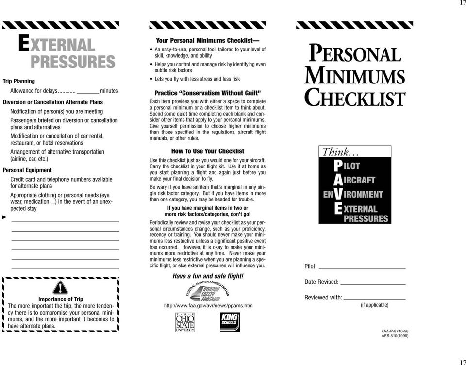
5 5 2. PAVE (Pilot-Aircraft-enVironment-External) The PAVE Checklist works like any checklist that you would use in your aircraft. However, you should expand the use of the PAVE to your flight planning as well, and take special consideration to each line item before your final decision to fly. The PAVE checklist will give you a step-by-step approach to assessing your knowledge, but leaves the final go-no-go decision to the PIC. Appendix B contains the FAA s PAVE risk assessment form, which contains instructions for use. This form contains a larger number of risk factors than the PAEDU tool, but is more qualitative. 3. Flight Risk Assessment The Flight Assessment Form, below, assigns a number to various risk factors regarding the pilot, aircraft, and environment. Each element is scored for the flight, and the totals and Grand Total determined. Then, the pilot is advised on the appropriate course of action depending on the Grand Total and whether the flight is VFR or IFR. These actions are: Go, for lowest Grand Total; Consider Alternate Actions; Consult Experienced CFI or Mentor; and Don t Go, for the highest Grand Total. See the attached form. Appendix A contains a scenario which uses the Personal Minimums Inventory and Checklist, and the Flight Assessment Form. This is to provide an example on how to use these forms. Appendix C contains the Flight Assessment Form. We have designed it on one page for ease of printing and use. B. Best Practices Weather Flight Planning 1. Sources of Information for Flight Planning There are many sources of weather information for flight planning. Telephone: FAA FSS WX-BRIEF Television: Weather Channel, News Internet: DUATS Association weather pages, e.g., AOPA, EAA National Weather Service (NWS) Aviation Digital Data Service (ADDS) Private weather services Airline Dispatchers Federation 2. Review the Information and Your Readiness for the Flight The quantity and quality of your weather information will have a direct affect on your weather planning. The factors that affect the adequacy of the quantity and quality of weather information for your decisions include: The severity of the consequences of being wrong. For example, what will happen if you inadvertently encounter: IMC conditions? Icing conditions? 5

6 6 Embedded thunderstorms? Other significant weather hazards? Your degree of certainty about information may be affected by: FAA approved source (e.g., DUATS, FSS, NWS, etc.) The duration of your flight The distances between reporting reports The proximity of the weather conditions to your personal minimums Your degree of confidence that you understand the weather situation. 3. Prepare Your Weather Map You should develop a weather picture over your intended route of flight. a. Using the information you have obtained, can you state or visualize a picture, both in plan view (from above) and in cross-section view (from the side, including terrain) of all the relevant weather on your flight/route, with other information, all of which are related to time. The information may include: Terrain (topography that includes natural and man-made obstructions). Cloud bases and tops. Icing levels. Winds aloft. Areas of IMC. Thunderstorm movement. b. Visualize your flight by drawing a weather picture of your flight. Draw a straight line between your two points. Draw an ellipse (actually a rough boundary line on either side of the straight line, the resulting lines will probably form an elliptical border around your intended route) to show an area where you will need information about weather that may affect your route of flight. Note the weather patterns within the elliptical area. Apply the information to your weather decisions. Construct a route to avoid weather that is hazardous to you and your airplane (given the capabilities of you and your airplane). c. Develop a primary flight plan (Plan A) to conduct your flight safely using your weather picture, by asking yourself. 1) What is the best plan to make the flight, within your personal minimums, considering: Your aircraft and its capabilities The environment, weather and terrain External factors, such as security restrictions, e.g., Temporary Flight Restrictions (TFRs) and Air Defense Identification Zones (ADIZs). 2) The plan is defined by: The route, The altitudes en route, and Time of departure 6

7 7 d. Develop an alternative flight plan (Plan B), to be executed when the actual weather you find en route is not what your weather picture was believed to be when you made Plan A. Determine under what conditions you will abandon Plan A and execute Plan B, based on changing weather conditions en route. Know your methods of exiting from weather hazards when conditions deteriorate by activating Plan B in order to remain within your personal minimums. Plan B is defined by: The new route, Changes in altitude, or The new destination. 4. Develop Plan B Your Alternative Actions At departure airport Proposed alternative action(s) to be taken Unplanned decision event Action(s) to be taken: Expectation of Success Enroute Unplanned decision event Action to be taken: Expectation of Success Unplanned decision event Action to be taken: Expectation of Success 7

8 8 At destination Unplanned decision event Action to be taken: Expectation of Success a. Your decision whether to execute Plan A, or to go to Plan B, will be based on a risk assessment. 1) This is a continuous process of evaluating the actual weather against your picture and deciding if the actual weather still meets your personal minimums. If you are within your personal minimums, you may stay with Plan A. If you are not within your personal minimums, or looks like it is not developing as you expected, you should immediately go to plan B. 2) Timely decisions are of utmost importance because a large number accidents are caused by pilots waiting too long to execute Plan B b. You must always have a safe out. If you are a relatively new VFR pilot, and Plan A has failed, and you have execute Plan B, and now it too is failing, you should realize that you may not have adequately assessed the weather conditions initially, and that Plan C should be to land as soon as practical. Then you can develop an entirely new set of plans in an environment where you have access to weather information from more detailed discussions with weather briefers on the phone and from computer weather graphics at the FBO. After plans A and B have not worked, you may not be able to construct a good Plan C in the air and simultaneously cope with adverse weather conditions at the same. In these circumstances, it is best to land and reassess the situation. c. During pre-flight preparation, should involve outside review at a specified risk level, independent, objective, knowledgeable review of your risk assessment using Peer review by fellow pilots, or consulting with an instructor or mentor (more experienced person) review. Once you re en route, the only outside review is likely to be Flight Service Station personnel, some of whom are experienced pilots as well as weather briefers. 8

9 9 APPENDIX A: SIMULATED VFR SCENARIO A VFR pilot, flying simple, single engine airplane on a personal transportation cross-country flight. Pilot a non-instrument rated, VFR pilot pilot is a 49 year old male pilot has 235 hours total time, 50 in the last year, and 30 in this or an identical airplane pilot has four years flying experience (since receiving first flight lesson) it is single pilot operation (no other pilots on board) flight will be commenced after the end of a work day pilot has not flown in one month, has 25 landings in the last year, only two strong crosswind or gusty pilot has 3 night hours in the last year, and 2 night landings. Pilot has no high density altitude or mountainous terrain operations in the last year pilot has a total of three hours hood time and no actual (IMC) experience pilot will be taking his family to the beach Aircraft aircraft is a Cessna 172 aircraft has two Nav/Com radios each with a VOR aircraft does not have a stormscope or an autopilot Mission June 21 departure at 1730 from Montgomery County Airpark, Maryland (KGAI) to First Flight Airport, Kitty Hawk North Carolina (KFFA) (both non-towered airports) estimated enroute time is three hours pilot is unfamiliar with destination there is no weather reporting at KFFA pilot plans to stay at hotel that requires check-in by 2100 Weather VFR is not recommended visibility is forecast enroute to be 4 to 5 miles forecast includes possible ground fog in KFFA area PILOT FACTS Pilot Condition Fatigue? Sleep within last 24 hours? 6 hours Sleep deficit (long term)? No Workday preceding flight? Yes, 8 hours Food and water When was last meal? Noon When last water? 4 PM Alcohol Within last 24 hours? None Drugs/Medication(s) None Stressful event(s)? Daughter s marriage Previous weekend 9

10 10 Illness(es)? yes What 24 hour flu When one week before Still affecting? Yes, still a little weak Pilot Qualifications (update as necessary) Private ASEL, no instrument rating Total time 235 hours Total instrument time 3 hours (all hood time, none in aircraft) Total time in aircraft 100 hours Pilot Proficiency and or Recency (update as necessary) Last Flight Review July, 12 months earlier Last recurrent training Private rating, four years earlier Last 90 days Flight time Total 2 hours In aircraft 2 hours IMC time none Simulated IFR none PCTAD 4 hours Take offs & landings 3 Day 3 Night 0 Significant crosswind no Personal Weather Minimums (comfort level) VFR Visibility 4 miles Ceilings 2500 feet Winds 10 knots Turbulence moderate AIRCRAFT FACTS Fuel reserves (for proposed flight) VFR, Day 2 hours Performance (for proposed flight) Gross weight at gross weight Load distribution within limits Density altitude 2500 feet Equipment (for proposed flight) Avionics - familiar and proficient? marginally proficient COM/NAV - appropriate to flight? yes Charts - current? yes Alternate landing sites yes Elizabeth City, NC Survival gear - appropriate for flight/terrain? none 10
 VFR")
11 11 ENVIRONMENT Airport(s) Conditions (for proposed flight) Departure airport Crosswind - % of maximum POH Runway length - % more than POH less than 50% more than 200% greater than required Destination airport Crosswind - % of maximum POH Runway length - % more than POH Weather reporting? ATC services? Radar services? less than 50% more than 200% greater than required none none none Weather (for proposed flight) Reports and forecasts how recent current For VFR flight or portion of flight Ceiling Day (feet) 3500 feet Night (feet) 1000 to 3000 feet Visibility Day (miles) 3 to 5 miles with haze Night (miles) 3 miles with haze EXTERNAL PRESSURES CHECKLIST Trip Planning time allowance for delays 15 minutes (plan to arrive 2030, 15 min. walk to hotel) Diversion/Cancellation Plans Notification of concerned persons? no Passengers briefed on possible changes no Hotel reservations none if late arrival Personal Equipment or Information Necessary For Alternative Plans Contact telephone numbers none Cash and/or checks yes Credit cards yes Clothing (extended stay) no 11
 1000 to 3000 feet Visibility Day (miles) 3 to 5 miles with haze Night (miles) 3 miles with haze EXTERNAL PRESSURES CHECKLIST Trip Planning time allowance for delays 15 minutes (plan")
12 12 Personal Minimums Inventory and Checklist Certification, Training and Experience Summary Assessment #1 Assessment #2 Certification (e.g., commercial, multi-engine; instrument rating) Highest certificate level and ratings (incl. Complex aircraft) ASEL, Hi Perf. Training Flight review: e.g., certificate, rating, Wings Program completion, etc. 7/2000 Instrument Proficiency Check N/A Time since checkout in airplane: CE-172 7/2000 Time since checkout in airplane: Time since checkout in airplane: Variation in Equipment (GPS navigator), number of different panels 9/01: 3 panels Experience Total flying time 235 Years flying 4 Hours in the last year 50 Hours in this or identical airplane in last year 30 Landings in last year 25 Night hours in last year 3 Night landings in last year 2 High density altitude hours in last year 0 Mountainous terrain hours in last year 0 Strong crosswind or gusty landings in last year 2 IFR hours in last year 0 Actual hours in IMC in the last year 0 Approaches (actual or simulated) in last year 0 Condition Example 1: 100 Example 2: Your Personal hour VFR Pilot 300 hour IFR Pilot Minimums Minimum Visibility Day VFR 5 miles 3 miles 4 Minimum Visibility Night VFR 7 miles 5 miles 5 Minimum Ceiling Day VFR 3,000 feet 2,000 feet 2500 Minimum Ceiling Night VFR 5,000 feet 3,000 feet 4000 Surface Wind Speed & Gusts 15 knots 5 knot gust Same 15 knots 5 knot gust Maximum Cross Wind 7 knots Same 7 knots Other VFR (e.g. mountain flying, over water beyond gliding distance) Consult your instructor/mentor Same IFR Approach Ceiling N/A Minimums plus 500 feet N/A OFR Approach Visibility N/A Minimums plus N/A ½ mile Other IFR (e.g. icing) N/A Consult your N/A instructor/mentor Consult your instructor/mentor 12

13 13 FLIGHT ASSESSMENT (1) Pilot Personal Factors Assessment Form VFR = VFR pilot on VFR flight plan IFR = IFR current pilot on IFR flight plan PERSONAL FACTOR ITEM VFR Pilot IFR Pilot Score Less than 100 hours in type - has 100 hrs Unfamiliar destination yes Fatigue (less than normal sleep prior night) yes Flight after end of work day yes Scheduled commitment after flight yes Recent death of close family member no Major domestic problems no Illness in family no Second pilot who is rated and current no Alcohol within the last 24 hours no Taking over the counter medication no Inadequate food prior to flight no Inadequate water prior to flight/ no water on board - no Day > 10,000 PA with no supplemental oxygen no Night > 5,000 PA with no supplemental oxygen no Flight duration more than 3 hours no TOTAL PILOT SCORE +8 (2). Aircraft Operational Assessment Form OPERATIONAL FACTOR ITEM VFR IFR SCORE Fuel calculation completed for flight with reserves for day/night conditions - yes Total fuel required for flight with reserves for day/night conditions less than 60% of available fuel no Weight & balance calculation made yes Weight w/in 10% max. gross yes Takeoff or landing distance more than 50% of intended runways to be used no TOTAL AIRCRAFT SCORE 0 13

14 14 (3) Environment Assessment Form ENVIRONMENT FACTOR ITEM VFR IFR Score Visibility 3 to 5 miles yes Visibility 1 to 3 miles no Destination visibility less than 1 mile no Ceilings less than 3,000 AGL yes Destination ceilings less than 1,000 feet AGL no Destination ceilings less than 500 feet AGL no Convective activity within 20 NM of flight no Convective activity with no storm scope or other means of detection capability no Convective activity with detection capability no Destination dew point spread less than 3 yes No de-icing equipment surface temperatures less than 40 F and clouds or precipitation no Icing forecast (AIRMET more than light) at altitude required to fly with de-icing equipment no N/A Operational control tower at destination no VASI/PAPI at destination no Radar environment at destination no Mountainous terrain no Approach/departure over water yes High bird hazard no Unpaved runway no IFR and only approach is non-precision N/A + 2 Weather reporting at airport - no Precipitation causing obstruction to visibility - no Wet runway no Ice on runway no Cross wind in excess of 90% demonstrated maximum cross wind in Pilot Operating Handbook no Using flight following or radar advisories in high density traffic areas no - 1 n/a 0 On IFR Flight plan in VFR conditions no - 1 n/a 0 TOTAL ENVIRONMENT SCORE
 at altitude required to fly")
15 15 (4) VFR Pilot Scoring Total Pilot Factor Score Total Aircraft Factor Score Total Environment Factor Score Grand Total of Points (5) Action to be Taken Based on Flight Assessment Risk Factor Grand Total Action Minimal Less than 7 Go Low 7 to 10 Consider alternate actions to reduce risk Medium Consult a CFI experienced in the type of flight you propose to make High More than 15 Don t go Based on the above score, the pilot should not to make the flight. OTHER SCENARIOS An IFR pilot flying complex, single engine airplane in icing or thunderstorms An IFR pilots flying complex, single engine airplane or multiengine airplane with ice protection equipment and airborne weather radar, and Various typical rotorcraft operations 15

16 APPENDIX B, PERSONAL MINIMUMS CHECKLIST 16 16

17 17 17
18 Appendix C Flight Assessment Form VFR = VFR pilot on VFR flight IFR = IFR current pilot on IFR flight Pilot Factor VFR IFR Score Less than 100 hours in type Unfamiliar Destination Fatigue (less than normal sleep prior night) Flight at end of work day Scheduled commitment after flight Recent death of close family member Major domestic problems Illness in family Second pilot who is rated and current Alcohol within the last 24 hours Taking over the counter medication Inadequate food prior to flight Inadequate water prior to flight/no water on board Day > 10,000 PA with no supplemental Oxygen Night > 5,000 PA with no supplemental Oxygen Flight duration more than 3 hours TOTAL Aircraft Factor VFR IFR Score Fuel calculation completed for flight with reserves for day/night conditions Total fuel required for flight with reserves for day/night conditions less 60% of available fuel Weight and balance calculated Weight within 10% of maximum gross Takeoff or landing distance more than 50% of runway length TOTAL Environment Factor VFR IFR Score Visibility 3 to 5 miles Visibility 1 to 3 miles Destination visibility less than 1 mile Ceilings less than 3,000 AGL Destination ceilings less than 1,000 AGL Destination ceilings less than 500 AGL Convective activity within 20 NM of flight path Convective act./ no storm-scope/detection capability Convective activity with detection capability 0-2 Destination dew point spread less than No de-icing equipment, surface temperature less than 40 F, and low clouds or precipitation Icing forecast (AIRMET more than light) at altitude N/A + 2 required to fly with de-icing equipment Operational control tower at destination VASI/PAPI at destination Radar environment at destination Mountainous terrain Approach/departure over water High bird hazard Unpaved runway IFR and only approach is non-precision N/A + 2 Weather reporting at airport Precipitation causing obstruction to visibility Wet runway Ice on runway Crosswind 90% of max POH Using flight following/radar advisories in high - 1 N/A density traffic areas On IFR flight plan during VFR conditions - 1 N/A TOTAL GRAND TOTAL VFR Grand Total VFR Action IFR Grand Total IFR Action Minimal Less than 6 Go Less than 7 Go Low 6 to 8 Consider alternate actions 7 to 10 Consider alternate actions Medium 9 to 14 Consult experienced CFI 11 to 15 Consult experienced Instrument CFI High More than 14 Don t go More than 15 Don t go

Helicopter Association International Pre-Flight Risk Assessment Tool User s Guide BETA
 Helicopter Association International Pre-Flight Risk Assessment Tool User s Guide BETA http://www.rotor.com/fra TABLE OF CONTENTS Overview... 2 Quick Guide... 7 How to Register and setup the system...
Virginia Office of Emergency Medical Services Medevac Best Practice 2.2.2 Risk Assessment. Proposed April 24, 2008
 Medevac Best Practice 2.2.2 Risk Assessment Proposed April 24, 2008 Office of Emergency Medical Services P.O. Box 2448 Richmond, Virginia 23218 (804)864-7600 www.vdh.virginia.gov/oems Virginia Medevac
Exemption No. 10513A Regulatory Docket No. FAA-2011-1070
 January 30, 2013 Exemption No. 10513A Regulatory Docket No. FAA-2011-1070 Mr. Alan M. Hoffberg Board Secretary/Director Angel Flight Southeast, Inc., and Mercy Flight Southeast 8864 Airport Boulevard Leesburg,
Federal Aviation Administration. Best Practices for Mentoring in Flight Instruction rev 160120
 Federal Aviation Administration Best Practices for Mentoring in Flight Instruction rev 160120 Best Practices for Mentoring in Aviation Education Acknowledgements Introduction What Is Mentoring? Definition
Pilot Professionalism It Isn t Just For The Big Guys
 Pilot Professionalism It Isn t Just For The Big Guys Earl F Weener Board Member American Bonanza Society Convention & Trade Show Buffalo, NY September 25, 2010 Pilot Professionalism - NTSB Interest Lack
Flight Training Program Outline Single-Engine Instrument Rating
 Flight Training Program Outline Single-Engine Instrument Rating Last updated November 2014 Table of Contents Introduction:... Error! Bookmark not defined. Privileges:... 2 Prerequisites:... 2 Cost Breakdown...
Instrument Pilot Rating Course (ASEL) Training Syllabus FAR Part 61
 Training Syllabus FAR Part 61") Instrument Pilot Rating Course (ASEL) Training Syllabus FAR Part 61 Property of Tech Aviation Flight School. Reproduction of this manual in full or part is strictly prohibited by law. Distribution or use
Instrument Pilot Rating Course (ASEL) Training Syllabus FAR Part 61 Property of Tech Aviation Flight School. Reproduction of this manual in full or part is strictly prohibited by law. Distribution or use
Oral Preparation Questions
 Oral Preparation Questions The oral section of the practical test is the time when you need to demonstrate your understanding of the various tasks listed in the practical test standards and the factors
Providing Flight Training at:
 Providing Flight Training at: The G. O. Carlson / Chester County Airport Business Route 30, in Valley Township 1 Earhart Drive, Suite 4, Coatesville, PA 19320 610-384-9000 www.chestercountyaviation.com
CHAPTER 7. AIRSPACE 7.1 AFFECTED ENVIRONMENT
 CHAPTER 7. AIRSPACE 7.1 AFFECTED ENVIRONMENT 7.1.1 Definition of Resource Airspace management is defined as directing, controlling, and handling flight operations in the volume of air that overlies the
Inoperative Equipment
 Inoperative Equipment Reference Sources Advisory Circular AC91-67 Minimum Equipment Requirements for General Aviation Operations under FAR Part 91 ( Definitions section at minimum) Title 14 Code of Federal
SPORT PILOT TRAINING SYLLABUS
 Checked out from the Members Only Library Page 1 of 13 Society of Aviation and Flight Educators www.safepilots.0rg SPORT PILOT TRAINING SYLLABUS LESSON ONE: INTRODUCTORY FLIGHT TIME: 1 hour Ground Instruction;
The Basis for Our Decision
 October 31, 2014 Exemption No. 10009C Regulatory Docket No. FAA-2009-0702 Mr. Stephen Craven Angel Flight Mid-Atlantic Airlift Hope of America Mercy Medical Airlift 4620 Haygood Road, Suite 1 Virginia
FACTUAL REPORT AVIATION
 Location/Time Aircraft Registration Number: Most Critical Injury: Minor Investigated By: NTSB N911BL Nearest /Place Zip Code Local Time Time Zone Las Vegas NV 89032 1600 PDT Airport Proximity: On Airport/Airstrip
The Art of Aeronautical Decision-Making Course Table of Contents
 Federal Aviation Administration The Art of Aeronautical Decision-Making Course Table of Contents Introduction Chapter 1 Chapter 2 Chapter 3 Chapter 4 Chapter 5 Chapter 6 Chapter 7 What is ADM? 3-P Model
U.S. DEPARTMENT OF TRANSPORTATION FEDERAL AVIATION ADMINISTRATION. National Policy. SUBJ: OpSpec A021, Helicopter Air Ambulance (HAA) Operations
 Operations") NOTICE U.S. DEPARTMENT OF TRANSPORTATION FEDERAL AVIATION ADMINISTRATION National Policy N 8900.A021 Effective Date: XX/XX/XX Cancellation Date: XX/XX/XX SUBJ: OpSpec A021, Helicopter Air Ambulance (HAA)
NOTICE U.S. DEPARTMENT OF TRANSPORTATION FEDERAL AVIATION ADMINISTRATION National Policy N 8900.A021 Effective Date: XX/XX/XX Cancellation Date: XX/XX/XX SUBJ: OpSpec A021, Helicopter Air Ambulance (HAA)
BEFORE YOU GET STARTED
 is a small highly professional flight training organisation operating from the at Albion Park just 15 mins South of Wollongong City. is the Premier Flight Training Organisation on the NSW South Coast.
InFO Information for Operators
 InFO Information for Operators U.S. Department InFO 07015 of Transportation DATE: 7/3/2007 Federal Aviation Administration Flight Standards Service Washington, DC http://www.faa.gov/other_visit/aviation_industry/airline_operators/airline_safety/info
Instructional Accidents
 Instructional Accidents Challenge and Opportunity Presented to: By: Date: NTSB Seminar Jim Viola July 2015 A system in equilibrium All we ve done has brought us here. Continue to maintain position Innovate
Service, Security, Solutions Since 1924. Insurance and Risk Management Considerations for UAS RPAS Symposium, Montreal. March 2015
 Service, Security, Solutions Since 1924 Insurance and Risk Management Considerations for UAS RPAS Symposium, Montreal Global Aerospace Begins Spirit of St. Louis First Transatlantic flight by unmanned
WHICH AIR TRAFFIC CONTROLLER TO CONTACT
 WHICH AIR TRAFFIC CONTROLLER TO CONTACT 1. Introduction This article is written in order to explain to all beginners in the IVAO network the basics for any pilot to contact the correct air traffic controller.
AWE: Aviation Weather Data Visualization
 AWE: Aviation Weather Data Visualization Lilly Spirkovska NASA Ames Research Center Suresh K. Lodha University of California, Santa Cruz Abstract The two official sources for aviation weather reports both
Flight Instructor Training Module For Inclusion in FAA-Approved Flight Instructor Refresher Clinics
 For Inclusion in FAA-Approved Flight Instructor Refresher Clinics Volume 2: System Safety Course Developers Guide Flight Standards Service General Aviation and Commercial Division, AFS-800 Table of Contents
Appendix A Emergency Procedures
 Appendix A Emergency Procedures Introduction Changing weather conditions, air traffic control (ATC), aircraft, and pilots are variables that make instrument flying an unpredictable and challenging operation.
Airspace. Chapter 14. Introduction
 Chapter 14 Airspace Introduction The two categories of airspace are: regulatory and nonregulatory. Within these two categories there are four types: controlled, uncontrolled, special use, and other airspace.
Providing Flight Training at:
 Providing Flight Training at: The G. O. Carlson / Chester County Airport Business Route 30, in Valley Township 1 Earhart Drive, Suite 4, Coatesville, PA 19320 610-384-9005 www.chestercountyaviation.com
CENTRAL TEXAS COLLEGE SYLLABUS FOR AIRP 1307 AVIATION METEOROLOGY Semester Hours Credit: 3
 CENTRAL TEXAS COLLEGE SYLLABUS FOR AIRP 1307 AVIATION METEOROLOGY Semester Hours Credit: 3 INSTRUCTOR: OFFICE HOURS: I. INTRODUCTION A. The purpose of this course is to study Meteorology as it applies
VFR. into IMC. Helping students avoid GA s number one killer
 VFR into IMC Helping students avoid GA s number one killer DALE R. WILSON, MCFI In spite of safety improvements over the years, continued visual flight rules (VFR) flight into instrument meteorological
Private Pilot Checkride Checklist
 Private Pilot Checkride Checklist From the PPSEL/CPSEL Flight Instructor Notebook Bridgette Doremire Gene Hudson PRIVATE PILOT CHECKRIDE CHECKLIST Private Pilot Checkride Checklist Part 61 Student Pilot
Gold Seal Online Ground School www.onlinegroundschool.com
 Weather Charts and Reports Relating to weather reports: Ceiling Lowest layer of broken or overcast clouds IFR Ceilings less than 1,000 feet or visibilities less than three statute miles MVFR Ceilings between
LONDON SOUTHEND AIRPORT CLASS D CONTROLLED AIRSPACE GUIDE
 CLASS D CONTROLLED AIRSPACE GUIDE Introduction From the 2 nd of April 2015 London Southend Airport (LSA) will be implementing Class D (CAS). This airspace is made up of a Control Zone (CTR) and Control
Flight Operations Manual
 451 Airport Road Novato, CA 94945 415-717-1189 Flight Operations Manual Procedures in this publication are derived from procedures in the Federal Aviation Administration (FAA) Approved Airplane Flight
How To Operate A Helicopter
 ANNEX A Summary of Air Transport standards that have additional compliance or relief considerations Page A1 A.1 General principles The operator will: hold an AT AOC in accordance with Part 119 of CASR
NAMIBIAN RADIO LICENSE VALIDATION
 NAMIBIAN RADIO LICENSE VALIDATION Introduction This procedure is provided as a guide for applicants wishing to complete a Namibian Radio license validation, a requirement of a Namibian Pilot License Validation.
Letter from the Chief
 Welcome Packet Table of Contents Letter from the Chief... 3 Conquering the Skies with Viking aviation... 4 Frequently Asked Questions... 5 Student Pilot Web Resources... 8 Training And Rental Planes...
June 22, 2011 Exemption No. 10294 Regulatory Docket No. FAA-2011-0324
 June 22, 2011 Exemption No. 10294 Regulatory Docket No. FAA-2011-0324 Mr. Joseph Howley Chairman of the Board of Directors Patient AirLift Services, Inc. 120 Adams Boulevard Farmingdale, NY 11735 Dear
Multi-Engine Training And The PTS
 Multi-Engine Training And The PTS GHAFI John Sollinger/Larry Hendrickson October 28, 2000 Overview FAR differences between original and add-on Multi-Engine PTS Training methods Common training scenarios
2014 NIFA CRM Contestant Briefing Guide San Diego, California
 2014 NIFA CRM Contestant Briefing Guide San Diego, California Region 2 SAFECON 2014 November 12 15 This document supports the 2014 NIFA Collegiate Cockpit Resource Management Simulation and is not for
Flight Operations Briefing Notes
 Flight Operations Briefing Notes I Introduction Encountering wake turbulence in flight can be a surprising experience, both for crews and passengers. Wake turbulence occurs suddenly, and is usually accompanied
8-1 Chapter 8 Radio Operations: Aviation Spoken Here
 8-1 Chapter 8 Radio Operations: Aviation Spoken Here Radio Technique 1. [8-2/1/1] Using the radio is no great mystery. When transmitting, hold the radio close to your. A. mouth B. ear C. tongue VHF Transmitions
Flight Training Program Outline Recreational Pilot Permit
 Flight Training Program Outline Recreational Pilot Permit Last updated September 2015 Table of Contents Introduction:... 1 Privileges:... 1 Prerequisites:... 2 Cost Breakdown... 2 Age... 3 Medical Fitness
FACTUAL REPORT AVIATION
 Aircraft Registration Number: N8098T Occurrence Date: Occurrence Type: 03/07/005 Accident Most Critical Injury: Minor Investigated By: NTSB Location/Time Nearest City/Place Shreveport Zip Code Local Time
Making Aviation Safer: Results of the National Aviation Weather Program s 10-Year Goal to Reduce Weather- Related Accidents by 80 Percent
 1 Making Aviation Safer: Results of the National Aviation Weather Program s 10-Year Goal to Reduce Weather- Related Accidents by 80 Percent Friends/Partners of Aviation Weather October 9, 2008 Jud Stailey,
Introduction. Anatomy of a Good Weather Briefing. How to Obtain a Good Weather Briefing
 Introduction Here are some tips on how to get a good weather briefing. This document complements other pilot educational material published by the Federal Aviation Administration (FAA) and other aviation
Flight Review. The flight review is required by Federal Aviation Regulations for all pilots who intend to act as pilot in command of an aircraft.
 S A F E T Y A D V I S O R Regulations No. 2 Pilot s Guide to the Flight Review This Safety Advisor provides guidance to pilots and flight instructors for the conduct of flight reviews and to convey current
Oklahoma State University
 Oklahoma State University Stillwater, Oklahoma Standard Operating Procedures & Student Information Manual 1 PREFACE Welcome to the Oklahoma State University Aviation Program. Everyone involved with the
AIRCRAFT NOISE ABATEMENT OPERATING PROCEDURES AND RESTRICTIONS
 AIRCRAFT NOISE ABATEMENT OPERATING PROCEDURES AND RESTRICTIONS This section sets forth the Los Angeles World Airports (LAWA s) informal noise abatement traffic; flight and runway use procedures and includes
Maryland State Firemen s Association Executive Committee Meeting December 5, 2009
 Maryland State Firemen s Association Executive Committee Meeting December 5, 2009 Maryland State Police Aviation Command Update Presented by: Major Andrew J. (A. J.) McAndrew Hello, my name is Major A.
AIRCRAFT PERFORMANCE Pressure Altitude And Density Altitude
 Performance- Page 67 AIRCRAFT PERFORMANCE Pressure Altitude And Density Altitude Pressure altitude is indicated altitude corrected for nonstandard pressure. It is determined by setting 29.92 in the altimeter
FAA-P-8740-52 AFS-820-2000
 S1 Introduction You fly in actual instrument weather conditions and make enough approaches to keep "current," take your flight review from a good instructor, know the "Normal" and "Emergency" procedure
Providing Flight Training at:
 Providing Flight Training at: The G. O. Carlson / Chester County Airport Business Route 30, in Valley Township 1 Earhart Drive, Suite 4, Coatesville, PA 19320 610-384-9005 www.chestercountyaviation.com
Part 135. Air Operations Helicopters and Small Aeroplanes. CAA Consolidation. 24 September 2015
 Part 135 CAA Consolidation 24 September 2015 Air Operations Helicopters and Small Aeroplanes Published by the Civil Aviation Authority of New Zealand DESCRIPTION Part 135 prescribes the operating requirements
Training program for S2 (TWR) rating
 rating") Training program for S2 (TWR) rating Introduction This is the official Vatsim Scandinavia training program for students training for the TWR (S2) Rating. Each mentor is expected to take his student through
Training program for S2 (TWR) rating Introduction This is the official Vatsim Scandinavia training program for students training for the TWR (S2) Rating. Each mentor is expected to take his student through
Charter Services. Frequently Asked Questions
 Charter Services Frequently Asked Questions What advantages does chartering a private airplane have over traveling with the commercial airlines? Chartering a private aircraft provides you with numerous
SEA LAND AIR LEARNING TO FLY AT
 LEARNING TO FLY AT SEA LAND AIR Sea Land Air Flight Centre (SLA) is a new generation aviation service provider that offers you a unique experience of flight training and aircraft rental. Our mission is
Understanding the altimeter
 Understanding the altimeter What you see isn't always what you have by Jack Willams Flying is an adventure for most pilots--sometimes more adventure than they really want. A pilot's report to Canada's
National Aviation Weather Program Mid-Course Assessment
 National Aviation Weather Program Mid-Course Assessment Accident Reduction Trends Confirm Value of Coordinated R&D Programs Prepared by the Office of the Federal Coordinator for Meteorological Services
VFR Regulations Summary
 Gold Seal Online Ground School www.onlinegroundschool.com VFR Regulations Summary Pilot in Command The pilot in command is directly responsible for and the final authority as to the operation of the aircraft.
N17UF Most Critical Injury: FATAL ACCIDENT
 Location/Time Nearest City / Place Page 1 Aircraft Registration Number N17UF Most Critical Injury: FATAL Investigated By: AAIPU Occurrence Date: Nov. 9, 2014 Occurrence Type: Zip Code ACCIDENT Local Time
Compiled by Matt Zagoren
 The information provided in this document is to be used during simulated flight only and is not intended to be used in real life. Attention VA's - you may post this file on your site for download. Please
per day, air traffic controllers help a pilot by performing a
 S A F E T Y A D V I S O R Operations and Proficiency No. 7 Say Intentions... When you need ATC s help There are several reasons that pilots do not call air traffic control (ATC) for help: They feel in
2014 UPDATES. Current Through: 03/06/14
 2014 UPDATES Current Through: 03/06/14 The Gleim FAR/AIM is published annually. Gleim keeps you up-to-date with FAA changes via online and email updates. Changes to the FARs can be released by the FAA
Background on Airspace
 Background on Airspace There are six classifications of airspace in the United States; A, B, C, D, E, and G. Class A is the most restrictive and Class G the least restrictive. They can be categorized as:
H is for HELP! He was employed as an EMS pilot in Buffalo New York for about 2 years, than transferred to work as a relief pilot through out WI.
 H is for HELP! Wind Turbines and EMS helicopters in Wisconsin This interview with retired EMS pilot Ray Slavik, was submitted to the Calumet County Ad Hoc Committee researching proposed ordinances governing
For the purpose of see-and-avoid, visual observers must be utilized at all times
 2009-WSA-92 WARNING: This correspondence may contain Sensitive Security Information and attachments that are controlled under 49 CFR 15 and 1520. No part of this correspondence may be disclosed to persons
and Implementing Rules for Air Operations of Community Operators F. Cross Reference Tables
 European Aviation Safety Agency 30 Jan 2009 NOTICE OF PROPOSED AMENDMENT (NPA) NO 2009 02F DRAFT OPINIONS OF THE EUROPEAN AVIATION SAFETY AGENCY, FOR A COMMISSION REGULATION establishing the implementing
Light Sport West Standard Flight Training Procedures for N110GX (Remos GX, 100 H.P.)
") Light Sport West Standard Flight Training Procedures for N110GX (Remos GX, 100 H.P.) Welcome to Light Sport West! Thank you for giving us the opportunity to provide all of your flight training needs. Our
Light Sport West Standard Flight Training Procedures for N110GX (Remos GX, 100 H.P.) Welcome to Light Sport West! Thank you for giving us the opportunity to provide all of your flight training needs. Our
Flight information that keeps pilots a step ahead.
 Integrated Flight Information system Flight information that keeps pilots a step ahead. At Rockwell Collins, we re ushering in the era of the truly paperless flight deck while providing a higher level
FAR/AIM Sport Pilot Study Guide
 This FAR/AIM Study Guide is meant to be used with Sport Pilot Checkride by Paul Hamilton (#ASA-F2F-CKRIDE) to help sport pilot license candidates understand regulations affecting pilots flying LSA. Specific
Cessna 172SP & NAV III Maneuvers Checklist
 Cessna 172SP & NAV III Maneuvers Checklist Introduction Power Settings This document is intended to introduce to you the standard method of performing maneuvers in Sunair Aviation s Cessna 172SP and NAV
Takeoff Tools TM Crosswind Calculator Instructions Copyright 2005 by Eric C. King. All rights reserved. Rev. 11Sep05. How to Use
 Takeoff Tools TM Crosswind Calculator Instructions Copyright 2005 by Eric C. King. All rights reserved. Rev. 11Sep05 Takeoff Tools TM Suppose you re arriving at, or about to depart from, an airport. You
For Flight Simulation purposes only on the VATSIM Network.
 Compiled by Daniel A. Hawton, ZDC Training Administrator For Flight Simulation purposes only on the VATSIM Network. Introduction The goal of the document is to introduce you, the controller, to the appropriate
SIXTH MEETING SUMMARY
 WAFSOPSG/6-IP/13 3/3/ /11 WORLD AREAA FORECAST SYSTEM OPERATIONS GROUP (WAFSOPSG) SIXTH MEETING Dakar, Senegal, 21 to 24 March 2011 Agenda Item 6: Development of the WAFS 6.1: Improved GRIB 2 forecasts
We can arrange direct transportation from PBI, FLL, or MIA. From there you can be taken directly to your hotel or chosen living accommodation.
 WELCOME TO PALM BEACH HELICOPTERS Thank you for inquiring about Helicopter training with Palm Beach Helicopters! Palm Beach Helicopters provides quality Flight Training awarding students from all over
Aeronautical Decision-Making
 Chapter 17 Aeronautical Decision-Making Introduction Aeronautical decision-making (ADM) is decision-making in a unique environment aviation. It is a systematic approach to the mental process used by pilots
LOUISIANA TECH UNIVERSITY DEPARTMENT OF PROFESSIONAL AVIATION PART 141 FLIGHT SCHOOL
 LOUISIANA TECH UNIVERSITY DEPARTMENT OF PROFESSIONAL AVIATION PART 141 FLIGHT SCHOOL INSTRUMENT RATING CERTIFICATION COURSE GROUND AND FLIGHT TRAINING MANUAL October 15, 2008 LIST OF EFFECTIVE PAGES October
Radio Communications in Class D Airspace by Russell Still, Master CFI
 Radio Communications in Class D Airspace by Russell Still, Master CFI Class D airspace is one of the most common parts of the airspace system that requires specific radio communications. Although you can
Ministry of Civil Aviation ECA 91-6 Egyptian Civil Aviation Authority. EAC No. 91_6. Issue 5, Rev. 0 Dated May, 2012 Pag e 1
 Ministry of Civil Aviation ECA 91-6 EAC No. 91_6 Issue 5, Rev. 0 Dated May, 2012 Pag e 1 ECA 91-6 Ministry of Civil Aviation UTABLE of CONTENTS 0BITEM 2B 1TEAC91-6:1T 5B 1TSECTION 1:1T 1TEAC 91-6.11T 1TEAC91-6.31T
18.0 Flying Training Authorisation on an AOC
 18.1 Introduction Flying training, is a commercial purpose as defined by CAR 206(1)(a)(vi), and it is required by s27(9) of the Act to be conducted under the authorisation of an AOC. CAR 206(1)(a)(vi)
Low Level Windshear Alert System (LLWAS) An integral part of the U.S. FAA Wind-shear safety program
 An integral part of the U.S. FAA Wind-shear safety program") Low Level Windshear Alert System (LLWAS) An integral part of the U.S. FAA Wind-shear safety program Low-level windshear is a hazard to aircraft in the airport runway corridors. With Climatronics LLWAS,
Low Level Windshear Alert System (LLWAS) An integral part of the U.S. FAA Wind-shear safety program Low-level windshear is a hazard to aircraft in the airport runway corridors. With Climatronics LLWAS,
Competency based Instrument Rating CB-IR(A)
") Send to: [email protected] or Luftfartstilsynet Postboks 243 81 BODØ Norway Approved application and report form for the Competency based IR(A) (CB-IR) Skill test, according to EASA Part FCL, Appendix
Send to: [email protected] or Luftfartstilsynet Postboks 243 81 BODØ Norway Approved application and report form for the Competency based IR(A) (CB-IR) Skill test, according to EASA Part FCL, Appendix
EMS Helicopter LOFT Study Shows Experience Influences Pilot Performance during Inadvertent Flight into IMC
 FLIGHT SAFETY FOUNDATION HELICOPTER SAFETY Vol. 22 No. 1 For Everyone Concerned with the Safety of Flight January February 1996 EMS Helicopter LOFT Study Shows Experience Influences Pilot Performance during
Logbook & Endorsement
 The Most Respected Name in Pilot Certification Airline Career Pilot Program Logbook & Endorsement Supplement Revised 2015-09-02 800-255-2877 904-273-3018 Revised 2015-09-02 Copyright 2015 Airline Transport
DIRECCION DE PERSONAL AERONAUTICO DPTO. DE INSTRUCCION PREGUNTAS Y OPCIONES POR TEMA
 MT DIREION DE PERSONL ERONUTIO DPTO. DE INSTRUION PREGUNTS Y OPIONES POR TEM Pag.: 1 TEM: 0321 INSTRUTOR_DVNED_06_ENR FLT & NVIGTION OD_PREG: PREGUNT: RPT: 6856 GIVEN: Departure path... straight out Takeoff
IMPACT OF ADS-B ON CONTROLLER WORKLOAD: RESULTS FROM ALASKA S CAPSTONE PROGRAM
 IMPACT OF ADS-B ON CONTROLLER WORKLOAD: RESULTS FROM ALASKA S CAPSTONE PROGRAM Arthur P. Smith and Anand D. Mundra, The MITRE Corporation, McLean, VA Abstract The Capstone program introduced avionics in
This section includes performance data on the King Air B200. Information consists of:
 King Air B200 POH Pilot's Operating Handbook: This section includes performance data on the King Air B200. Information consists of: 1. Critical Airspeeds 2. Operating NOTAMS 3. Fuel Loading Formula Checklists:
This document provides direction for the Great Basin and supplements the Interagency Incident Business Management Handbook, PMS-902.
 GREAT BASIN COORDINATING GROUP INTERAGENCY INCIDENT BUSINESS MGMT HANDBOOK SUPPLEMENT This document provides direction for the Great Basin and supplements the Interagency Incident Business Management Handbook,
Application for Special Flight Operations Certificate File # ABC123. Company Name Address Phone Email
 Application for Special Flight Operations Certificate File # ABC123 Company Name Address Phone Email NOTE: This sample is provided as is by flitelab.com It is meant for reference only. It should only be
Out of Control. HANG ON! It s GOING TO GET ROUGH! DISASTER is just ahead! DON T JUST SIT THERE DO SOMETHING!
 Out of Control Brent Anderson HANG ON! It s GOING TO GET ROUGH! DISASTER is just ahead! DON T JUST SIT THERE DO SOMETHING! No, we are not talking about the aircraft we re flying, but rather the way our
GOVERNMENT OF INDIA OFFICE OF THE DIRECTOR GENERAL OF CIVIL AVIATION TECHNICAL CENTRE, OPP SAFDURJUNG AIRPORT, NEW DELHI
 GOVERNMENT OF INDIA OFFICE OF THE DIRECTOR GENERAL OF CIVIL AVIATION TECHNICAL CENTRE, OPP SAFDURJUNG AIRPORT, NEW DELHI CIVIL AVIATION REQUIREMENT SECTION 7 FLIGHT CREW STANDARDS, TRAINING AND LICENSING
COMMUNICATIONS GROUND COMMUNICATIONS OUTLET (GCO)
") 388 COMMUNICATIONS GROUND COMMUNICATIONS OUTLET (GCO) An automatic, remotely controlled, ground to ground communications device. Pilots at non-tower airports may contact the local Air Traffic Control (ATC)
388 COMMUNICATIONS GROUND COMMUNICATIONS OUTLET (GCO) An automatic, remotely controlled, ground to ground communications device. Pilots at non-tower airports may contact the local Air Traffic Control (ATC)
AIRSPACE EXPLAINED. Separation of Traffic
 AIRSPACE EXPLAINED Airspace is an area of aeronautical knowledge that is commonly poorly demonstrated on airman practical tests. Even when airman applicants demonstrate knowledge of the airspace system
Federal Aviation Administration. Conducting an Effective Flight Review
 Federal Aviation Administration Conducting an Effective Flight Review Rev. October 2015 TABLE OF CONTENTS Acknowledgements Introduction Step 1: Preparation Managing Expectations Assignments Step 2: Ground
State University of New York Farmingdale State College Department of Aviation. FSC Aviation Accident Response Plan
 State University of New York Farmingdale State College Department of Aviation FSC Aviation Accident Response Plan Purpose: This response plan describes actions to be taken following Farmingdale State College
on a dark night departure
 The pilots of the Learjet air ambulance likely were affected by fatigue during the VFR departure; a controller failed to relay radar altitude warnings. BY MARK LACAGNINA on a dark night departure Photo
PF3 ATC at its best Version History
 The latest version of this document and the PF3 User Guide can always be found in the...\pf3\help folder after any update. 30 th May 2016 Version 3.1.18 FIXED a problem that could occur if an emergency
Security-related procedures and requirements are a fact of life for today's pilots, especially those who operate in the Washington, DC metropolitan
 Security-related procedures and requirements are a fact of life for today's pilots, especially those who operate in the Washington, DC metropolitan area Special Flight Rules Area (SFRA) and the DC Flight