Application of the Beach-fx Economic Model in St. Johns County, Florida
|
|
|
- Homer Jacobs
- 10 years ago
- Views:
Transcription
1 Application of the Beach-fx Economic Model in St. Johns County, Florida Jason Engle, P.E. Jacksonville District USACE US Army Corps of Engineers

2 Beach-fx Introduction St. Johns County Study Area Overview of Economic Data Requirements Details of Engineering Input Development Future Work

3 Beach-FX Overview Developed by the US Army Engineer Coastal Hydraulics Lab and the Institute for Water Resources (IWR) Economic storm damage model for sandy coastlines PC-based, GIS compatible Only approved/certified economic model for Federal Coastal Storm Damage Reduction studies

4 Beach-FX Overview Merges engineering and economic data Predicted storm response Database of damage elements Simulates project lifecycles 50-years, 300 lifecycles Outputs Average annual costs with/without project Alternative evaluation/optimization

5 Why Common Context for Local/Regional/National Prioritization of Projects Previous models locally-developed Inconsistent model assumptions Inadequate coastal processes Varying levels detail economic input

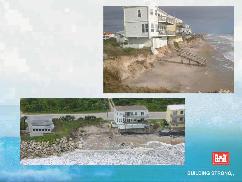
6 Study Area SOUTH PONTE VEDRA VILANO BEACH ST. AUGUSTINE INLET MATANZAS INLET SUMMER HAVEN FLAGLER COUNTY

7
8 Beach-fx Development Formulation of input data Economic Engineering Calibration Without-project simulations Alternative evaluation

9 Economic Inputs Geographic hierarchy Profiles, reaches, lots, damage elements Damage elements: anything of economic value Roads Buildings Pools Dune walkovers

10 Economic Inputs Reach/Lot/DE Attributes Armor status Armor rebuild cost/time Armor failure threshold Structure type Construction type Foundation type # Floors Dimensions XY coordinates Elevation Structure replacement $ Contents replacement $ GIS structure database has value beyond Beach-fx

11 Beach-fx Engineering Inputs Plausible storms Representative beach profiles Shore response database: storm induced profile changes

12 Historical Storms Tropical Storms/Hurricanes Derived from NOAA HURDAT database Water levels: HURDAT Waves: FCFP, WIS, SPM method St. Johns: 46 tropical storms/hurricanes Extra-tropical (Nor easters) NASA GISS Extra-tropical Storm Tracks ( ) Water levels: NOS gage data Wave data: FCFP, WIS St. Johns: 48 storms
 Water levels: NOS gage data Wave data:")
13 Plausible Storms Potential water levels occurring during passage of Tropical storms 3 Tide ranges: spring, neap, mean 4 tide stages: high, mid-falling, low, mid-rising 12 static water surface elevations 12 elevations x 46 storms 552 tropical storms + 48 nor easters Total of 600 plausible storms Used for both St. Johns and Flagler Counties

14 Representative Profiles Analysis of historical profile data Regions with similar profile dimensions Representative Profile (P5) Dune averaged profile aligned at 15 ft. Foreshore slope averaged profile aligned at 2 ft. Offshore averaged profile aligned at -25 ft. Within segment, averages taken through three sections St. Johns: 15 representative profiles Elevation (ft, NAVD88) Distance Offshore (ft)
 0-10 -20-30 -40-500 0 500 1000 1500 2000 2500 3000 3500 4000")
15 Simplified Profile Upland elevation Dune height Width Slope Berm Height Width Foreshore slope

16 Shore Response Profiles Starting with representative profile Range of possible future profiles Increments between a max/min profile St. Johns: 229 response profiles

17 Shore Responses SBEACH run for every profile/storm combination St. Johns: 600 storms x 229 profiles = 137,400 SBEACH runs SBEACH batch-run tool 30 batch runs Shore Response Database (SRD)

18 Shore Response Database SRD: database of storm-induced changes Berm width dune height dune width SBEACH calibrated for performance based on these three parameters

19 Beach-fx Calibration Goal: average erosion of many lifecycles = measured historical erosion Two model parameters Storm erosion: berm width recovery factor (~90%) Background erosion: applied erosion rate (ft/yr) Calibration not as time consuming as on engineering models like SBEACH, GENESIS

20 Summary GIS D.E. database a somewhat daunting task, but a valuable data set that can easily be integrated into a local/regional/state GIS databases. Engineering input data larger, but analysis is not more complicated use familiar engineering models. Coastal processes model are run outside of Beachfx, any improved/new models can easily be substituted in the future.

21 Future Work St. Johns County Beach-fx Complete without-project model runs Alternative evaluation/optimization Sensitivity testing of input variables First floor elevation Statistical assignment of D.E. variables
22 Jason Engle, P.E.
Hurricane and Storm Damage Reduction Study
 FLAGLER COUNTY FLORIDA Hurricane and Storm Damage Reduction Study Updated Project Management Plan - 2010 Presented by Dan Haubner Project Manager U.S. Army Corps of Engineers Jacksonville District R-1
Beach Management Funding Assistance Program
 FLORIDA DEPARTMENT OF ENVIRONMENTAL PROTECTION DIVISION OF WATER RESOURCE MANAGEMENT Beach Management Funding Assistance Program Local Government Funding Requests: Ranking Criteria for Beach and Inlet
Predicting Coastal Hazards: A Southern California Demonstration
 Predicting Coastal Hazards: A Southern California Demonstration Patrick Barnard United States Geological Survey Coastal and Marine Geology Team Santa Cruz, CA Southern California Multi-hazards Demonstration
Using LIDAR to monitor beach changes: Goochs Beach, Kennebunk, Maine
 Geologic Site of the Month February, 2010 Using LIDAR to monitor beach changes: Goochs Beach, Kennebunk, Maine 43 o 20 51.31 N, 70 o 28 54.18 W Text by Peter Slovinsky, Department of Agriculture, Conservation
SITE INVESTIGATIONS OF THE BEACH EROSION PROBLEM AT MAHO BEACH, ST. MAARTEN
 SITE INVESTIGATIONS OF THE BEACH EROSION PROBLEM AT MAHO BEACH, ST. MAARTEN Performed February 2003 Performed by: Dr. Lee E. Harris, Ph.D., P.E. Associate Professor of Ocean Engineering & Oceanography
SARASOTA COUNTY LIDO KEY HURRICANE & STORM DAMAGE REDUCTION PROJECT
 SARASOTA COUNTY LIDO KEY HURRICANE & STORM DAMAGE REDUCTION PROJECT Information Presentation BOCC Joint Meeting City of Sarasota Sarasota County US Army Corps of Engineers 22 October 2013 Sarasota, Florida
Tropical Storm Debby
 Tropical Storm Debby Post-Debby Beach/Dune Damage Assessment Report (Draft) Sarasota Florida By Weiqi Lin P.E., Ph.D. Coastal Resources/Community Services June 28, 2012 BACKGROUND AND SUMMARY Tropical
New Coastal Study for Puerto Rico FIRMs. Paul Weberg, FEMA RII Mat Mampara, Dewberry Jeff Gangai, Dewberry Krista Collier, Baker
 New Coastal Study for Puerto Rico FIRMs Paul Weberg, FEMA RII Mat Mampara, Dewberry Jeff Gangai, Dewberry Krista Collier, Baker September 2007 Project Team FEMA Region II Program Manager Collaboration
REGIONAL SEDIMENT MANAGEMENT: A GIS APPROACH TO SPATIAL DATA ANALYSIS. Lynn Copeland Hardegree, Jennifer M. Wozencraft 1, Rose Dopsovic 2 INTRODUCTION
 REGIONAL SEDIMENT MANAGEMENT: A GIS APPROACH TO SPATIAL DATA ANALYSIS Lynn Copeland Hardegree, Jennifer M. Wozencraft 1, Rose Dopsovic 2 ABSTRACT: Regional sediment management (RSM) requires the capability
Storm tide is the water level rise during a storm due to the combination of storm surge and the astronomical tide.
 INTRODUCTION TO STORM SURGE Introduction to Storm Surge BOLIVAR PENINSULA IN TEXAS AFTER HURRICANE IKE (2008) What is Storm Surge? Inland Extent Storm surge can penetrate well inland from the coastline.
An Initial Assessment of the Impacts of Sea Level Rise to the California Coast
 An Initial Assessment of the Impacts of Sea Level Rise to the California Coast Photo by D. Revell 2/23/08 California Coastal Records Project Dr. David Revell and Matt Heberger, P.E. Dr. Peter Gleick, Bob
Oakwood Beach Storm Damage Prevention Project NJDEP-Bureau of Coastal Engineering Glenn Golden, Project Manager U.S. Army Corps Civil Works Programs
 Oakwood Beach Storm Damage Prevention Project NJDEP- Glenn Golden, Project Manager U.S. Army Corps Civil Works Programs Branch Dwight Pakan, Project Manager, Philadelphia District The State of New Jersey
Tropical Storm Debby. Post-Debby Beach/Dune Damage Assessment Report Sarasota Florida. By Weiqi Lin P.E., Ph.D. Coastal Resources/Community Services
 Tropical Storm Debby Post-Debby Beach/Dune Damage Assessment Report Sarasota Florida By Weiqi Lin P.E., Ph.D. Coastal Resources/Community Services June 29, 2012 BACKGROUND AND SUMMARY Tropical storm Debby
Storm tide is the water level rise during a storm due to the combination of storm surge and the astronomical tide.
 INTRODUCTION TO STORM SURGE Introduction to Storm Surge National Hurricane Center Storm Surge Unit BOLIVAR PENINSULA IN TEXAS AFTER HURRICANE IKE (2008) What is Storm Surge? Inland Extent Storm surge can
ROLE OF THE MODELING, MAPPING, AND CONSEQUENCES PRODUCTION CENTER
 ROLE OF THE MODELING, MAPPING, AND CONSEQUENCES PRODUCTION CENTER Russ Wyckoff, P.E., CFM, MMC Modeling Lead, Tulsa District, USACE, Tulsa, Oklahoma, [email protected] ABSTRACT: The goal of
Appendix F Benefit-Cost Analysis of Flood Protection Measures
 Appendix F Benefit-Cost Analysis of Flood Protection Measures Acronyms used in Appendix F: AA B AA C AA D BC BFE EAD FEMA NED O&M PV RED USACE Average Annual Benefits Average Annual Cost Average Annual
Malcolm L. Spaulding Professor Emeritus, Ocean Engineering University of Rhode Island Narragansett, RI 02881
 Malcolm L. Spaulding Professor Emeritus, Ocean Engineering University of Rhode Island Narragansett, RI 02881 USACE Coastal and Hydraulics Laboratory(CHL) Data Infrastructure Workshop January 23, 2014 Overview
Hurricanes and Storm Surge www.hcfcd.org/tropicalweather
 Hurricanes and Storm Surge www.hcfcd.org High-level winds fl ow outward Strong surface winds spiral inward EYE Calm, sometimes cloudfree, sinking air Air sinks in calm area at the storm s eye THUNDERSTORMS
RESUME for Christopher G. Creed, P.E.
 Page One of Five Current Position Senior Engineer / Vice-President for Olsen Associates, Inc. a coastal engineering consulting firm in Jacksonville, Florida. Education Master of Civil Engineering, 1992.
FLOOD HAZARD IN THE URBAN ENVIRONMENT: IMPLICATIONS FOR DEVELOPERS, DESIGNERS, AND ATTORNEYS
 FLOOD HAZARD IN THE URBAN ENVIRONMENT: IMPLICATIONS FOR DEVELOPERS, DESIGNERS, AND ATTORNEYS PRESENTED BY: CHAD W. COX, P.E. DANIEL C. STAPLETON, P.E. BOSTON, MA JAN. 24, 2014 PRESENTATION Flood Vulnerability
FINAL INTEGRATED GENERAL REEVALUATION REPORT AND SUPPLEMENTAL ENVIRONMENTAL IMPACT STATEMENT
 FINAL INTEGRATED GENERAL REEVALUATION REPORT AND SUPPLEMENTAL ENVIRONMENTAL IMPACT STATEMENT BREVARD COUNTY, FLORIDA HURRICANE AND STORM DAMAGE REDUCTION PROJECT MID-REACH SEGMENT U.S. Army Corps of Engineers
STATUS REPORT FOR THE SUBMERGED REEF BALL TM ARTIFICIAL REEF SUBMERGED BREAKWATER BEACH STABILIZATION PROJECT FOR THE GRAND CAYMAN MARRIOTT HOTEL
 STATUS REPORT FOR THE SUBMERGED REEF BALL TM ARTIFICIAL REEF SUBMERGED BREAKWATER BEACH STABILIZATION PROJECT FOR THE GRAND CAYMAN MARRIOTT HOTEL performed by Lee E. Harris, Ph.D., P.E. Consulting Coastal
STORMS, INVESTOR DECISIONS, AND THE ECONOMIC IMPACTS OF SEA LEVEL RISE. 1. Introduction
 STORMS, INVESTOR DECISIONS, AND THE ECONOMIC IMPACTS OF SEA LEVEL RISE J. JASON WEST,, MITCHELL J. SMALL and HADI DOWLATABADI Center for Integrated Study of the Human Dimensions of Global Change, Department
THE HOMEOWNER S GUIDE TO THE COASTAL CONSTRUCTION CONTROL LINE PROGRAM (SECTION 161.053, FLORIDA STATUTES)
") THE HOMEOWNER S GUIDE TO THE COASTAL CONSTRUCTION CONTROL LINE PROGRAM (SECTION 161.053, FLORIDA STATUTES) The Florida Department of Environmental Protection Division OF Water Resource Management February
THE HOMEOWNER S GUIDE TO THE COASTAL CONSTRUCTION CONTROL LINE PROGRAM (SECTION 161.053, FLORIDA STATUTES) The Florida Department of Environmental Protection Division OF Water Resource Management February
REHABILITATION OF THE CHICAGO SHORELINE: A COASTAL ENGINEERING PERSPECTIVE
 REHABILITATION OF THE CHICAGO SHORELINE: A COASTAL ENGINEERING PERSPECTIVE Michael Krecic, P.E. Senior Engineer Taylor Engineering, Inc. 9000 Cypress Green Drive Jacksonville, FL 32256 Mark Wagstaff, P.E.
What causes Tides? If tidal forces were based only on mass, the Sun should have a tidegenerating
 What are Tides? Tides are very long-period waves that move through the oceans as a result of the gravitational attraction of the Moon and the Sun for the water in the oceans of the Earth. Tides start in
Strategic Beach Management Plan Southeast Atlantic Coast Region
 Page 1 of 66 Strategic Beach Management Plan Southeast Atlantic Coast Region Division of Water Resource Management Florida Department of Environmental Protection June 2015 Delray Beach Shore Protection
Raritan Bay and Sandy Hook Bay Highlands, New Jersey Coastal Storm Risk Management Feasibility Study. Appendix B Engineering July 2015
 Raritan Bay and Sandy Hook Bay Highlands, New Jersey Coastal Storm Risk Management Feasibility Study Appendix B Engineering July 2015 This page is intentionally left blank. Raritan Bay and Sandy Hook Bay,
Sea Level Change. Miami-Dade Sea Level Rise Task Force
 Sea Level Change and LongProgram Range Everglades Restoration Climate Water Resources Planning for Florida Change Application Concerns of USACE andguidance Draft Sea Level on Sea Rise Level Planning Change
HAZUS 2014. 7 th Annual Conference
 HAZUS 2014 7 th Annual Conference HAZUS Comparison of Storm Surge Levels from Different Hurricanes to the Newest SLOSH Models for Berkeley, Charleston, & Dorchester Counties Along the SC Coastline. Charlie
Mariana Leckner, Ph.D., Professor, American Military University Thomas O. Herrington, Ph.D. Associate Professor, Stevens Institute of Technology
 Mariana Leckner, Ph.D., Professor, American Military University Thomas O. Herrington, Ph.D. Associate Professor, Stevens Institute of Technology National Hydrologic Warning Council Training Conference
Hurricane Sandy: Beach-dune performance at New Jersey Beach Profile Network sites
 Hurricane Sandy: Beach-dune performance at New Jersey Beach Profile Network sites The Coastal Research Center (CRC) at the Richard Stockton College of New Jersey has been collecting beach and nearshore
Innovative Stormwater Solutions in Coastal Areas 2015 APWA Stormwater Conference
 Innovative Stormwater Solutions in Coastal Areas 2015 APWA Stormwater Conference September 15, 2015 Barrier Island Hydrology 2015 APWA Stormwater Conference September 15, 2015 2 Barrier Island Hydrology
Evaluating the Condition of Seawalls/Bulkheads
 Volume 2 Evaluating the Condition of Seawalls/Bulkheads By: Coastal Systems International, Inc. Typical bulkhead under construction Seawalls and bulkheads (walls) provide shoreline stabilization for many
asbpa Preserving our coastal economy and ecology since 1926
 Preserving our coastal economy asbpa and ecology since 1926 HEALTHY BEACHES ARE VITAL TO OUR WAY OF LIFE People in the United States highly prize the thousands of miles of sandy beaches along our nation
SHOALS Toolbox: Software to Support Visualization and Analysis of Large, High-Density Data Sets
 SHOALS Toolbox: Software to Support Visualization and Analysis of Large, High-Density Data Sets by Jennifer M. Wozencraft, W. Jeff Lillycrop, and Nicholas C. Kraus PURPOSE: The Coastal and Hydraulics Engineering
ebb current, the velocity alternately increasing and decreasing without coming to
 Slack water (slack tide): The state of a tidal current when its velocity is near zero, especially the moment when a reversing current changes its direction and its velocity is zero. The term is also applied
Scour and Scour Protection
 Design of Maritime Structures Scour and Scour Protection Steven A. Hughes, PhD, PE Coastal and Hydraulics Laboratory US Army Engineer Research and Development Center Waterways Experiment Station 3909 Halls
Most informed people realize that cumulative impacts have had
 Welcome to the First Issue of Rivers & Coast! The goal of the new Rivers & Coast newsletter is to keep readers well informed of current scientific understanding behind key environmental issues related
Section E2 Coastal Engineering: Reconstruction Management and Mitigation
 271 Section E2 Coastal Engineering: Reconstruction Management and Mitigation 272 Objectives To familiarize the assessor with the process that should be followed in organizing any reconstruction efforts.
Norfolk Flooding Strategy Update. Presentation to Norfolk City Council March 27, 2012
 Norfolk Flooding Strategy Update Presentation to Norfolk City Council March 27, 2012 Presentation Overview The purpose of this presentation is to provide City Council an update on activities carried out
The Use of Geographic Information Systems in Risk Assessment
 The Use of Geographic Information Systems in Risk Assessment With Specific Focus on the RiVAMP Methodology Presented by Nadine Brown August 27, 2012 Climate Studies Group Mona Climate Change Workshop Presentation
1. GENERAL ADVISORY BASE FLOOD ELEVATION (ABFE) QUESTIONS
 QUESTIONS") INTRODUCTION As communities begin to recover from the devastating effects of Hurricane Sandy, it is important to recognize lessons learned and to employ mitigation actions that ensure structures are rebuilt
INTRODUCTION As communities begin to recover from the devastating effects of Hurricane Sandy, it is important to recognize lessons learned and to employ mitigation actions that ensure structures are rebuilt
DRAFT. Shoreline adaptation alternatives development to determine flood reduction potential and project costs
 Scope of Services Phase 1A: Flood Damage Assessment Economic Analysis of the Delaware Bay Shoreline Adaptation Alternatives Task Order No. 1A Structures/Affected Property Inventory January 13, 2011 Johnson,
Flood Damage Mitigation And Insurance Costs
 Flood Damage Mitigation And Insurance Costs Friday, September 25, 2015 at 7:00 PM Saturday, September 26, 2015 at 10:00 AM This presentation was prepared by the Town of South Bethany using Federal Funds
MiSP CYCLIC PHENOMENA TIDES AND MOON PHASES Teacher Guide, L1 L3. Introduction
 MiSP CYCLIC PHENOMENA TIDES AND MOON PHASES Teacher Guide, L1 L3 Introduction This unit will be implemented a little differently than most of the other MiSP units. Instead of day 1 including an introduction
Coastal Engineering Indices to Inform Regional Management
 Coastal Engineering Indices to Inform Regional Management Lauren Dunkin FSBPA 14 February 2013 Outline Program overview Standard products Coastal Engineering Index Conclusion and future work US Army Corps
Impacts of Global Warming on North Carolina s Coastal Economy
 Impacts of Global Warming on North Carolina s Coastal Economy IMPACTS OF GLOBAL WARMING ON NORTH CAROLINA S COASTAL ECONOMY Key Findings Global warming is projected to have significant impacts on North
FINAL REPORT FOR 2012 ON THE CONDITION OF THE MUNICIPAL BEACHES IN THE CITY OF BRIGANTINE BEACH, ATLANTIC COUNTY, NEW JERSEY
 FINAL REPORT FOR 2012 ON THE CONDITION OF THE MUNICIPAL BEACHES IN THE CITY OF BRIGANTINE BEACH, ATLANTIC COUNTY, NEW JERSEY Photograph was taken November 3, 2012 from 10 th Street North looking south
BEACH NOURISHMENT COMBINED WITH SIC VERTICAL DRAIN IN MALAYSIA.
 BEACH NOURISHMENT COMBINED WITH SIC VERTICAL DRAIN IN MALAYSIA. Claus Brøgger 1 and Poul Jakobsen 2 The present paper presents measurements and results from a three year full scale Pilot Project with the
7.0 OTHER STUDIES 8.0 LOCATION OF DATA
 7.0 OTHER STUDIES Johnson Engineering prepared the Lee County Surface Water Management Plan for the Board of Lee County Commissioners in 1992. Johnson reviewed and modeled hydrology and hydraulics for
Tides and Water Levels
 Tides and Water Levels What are Tides? Tides are one of the most reliable phenomena in the world. As the sun rises in the east and the stars come out at night, we are confident that the ocean waters will
US Army Corps of Engineers BUILDING STRONG
 Fort Worth District Public Meeting 20 August 2013 US Army Corps of Engineers Lewisville Dam - Authorization Authorized by the River and Harbor Act, approved 2 March 1945 (Public Law 14, 79th Congress,
Federal Emergency Management Agency (FEMA) Preliminary Flood Insurance Rate Maps (FIRMs) and Preliminary Flood Insurance Study (FIS) for New York City
 Preliminary Flood Insurance Rate Maps (FIRMs) and Preliminary Flood Insurance Study (FIS) for New York City") March 10, 2014 Submitted electronically via http://www.nyc.gov Mayor s Office of Long Term Planning and Sustainability c/o Flood Map Comments 253 Broadway, 10th Floor New York, NY 10007 Federal Emergency
March 10, 2014 Submitted electronically via http://www.nyc.gov Mayor s Office of Long Term Planning and Sustainability c/o Flood Map Comments 253 Broadway, 10th Floor New York, NY 10007 Federal Emergency
Updated Federal Emergency Management Agency Flood Insurance Rate Maps and Zoning Ordinance Update. July 16, 2015 Policy Committee
 Updated Federal Emergency Management Agency Flood Insurance Rate Maps and Zoning Ordinance Update July 16, 2015 Policy Committee FEMA Map Update Costal Analysis and mapping study by FEMA in 2009 Changes
SPCC Plan - Calculation Guidance
 SPCC Plan - Calculation Guidance The following example compares two different design criteria: one based on the volume of the tank and one based on precipitation. Scenario: A 20,000-gallon horizontal tank
The Coast of Crystal Cove Orange County, California
 The Coast of Crystal Cove Orange County, California by Hany Elwany, Ph.D. Scripps Institution of Oceanography Megan Hamilton, M.Sc. Coastal Environments Robert Robinson Dept. of Parks & Recreation Headwaters
2. Market Area Background and Demographics Deliverable 1B
 2. Market Area Background and Demographics Deliverable 1B This section evaluates demographic and economic characteristics of the two principal sources of demand in the market area, the resident population
San Francisco Bay Margin Conservation Decision Support System (DSS)
") San Francisco Bay Margin Conservation Decision Support System (DSS) Presented by Brian Fulfrost1, MS David Thomson2, MS 1 Brian Fulfrost and Associates 2 San Francisco Bay Bird Observatory Transitional
San Francisco Bay Margin Conservation Decision Support System (DSS) Presented by Brian Fulfrost1, MS David Thomson2, MS 1 Brian Fulfrost and Associates 2 San Francisco Bay Bird Observatory Transitional
PALM BEACH COUNTY DEPARTMENT OF ENVIRONMENTAL RESOURCES MANAGEMENT
 PALM BEACH COUNTY DEPARTMENT OF ENVIRONMENTAL RESOURCES MANAGEMENT ENVIRONMENTAL ENHANCEMENT & RESTORATION DIVISION 2014 PALM BEACH COUNTY DEPARTMENT OF ENVIRONMENTAL RESOURCES MANAGEMENT MISSION STATEMENT
Structures Construction Pre-Work Checklist PRE-WORK SHEET FOR PROJECT MANAGERS
 Structures Construction Pre-Work Checklist PRE-WORK SHEET FOR PROJECT MANAGERS 1 Proposal & Plans Received? 2 Review Proposal, highlight important facts. Know proposal well to be able to find answers quickly.
Inlets Online: A Tutorial for Evaluating Inlet/Beach Processes Using Aerial Photography
 Inlets Online: A Tutorial for Evaluating Inlet/Beach Processes Using Aerial Photography by Mark R. Byrnes, Feng Li, and Julie D. Rosati PURPOSE: This Coastal and Hydraulics Engineering Technical Note (CHETN)
RESTORATION AND ENHANCEMENT OF SOUTHERN CALIFORNIA LAGOONS
 RESTORATION AND ENHANCEMENT OF SOUTHERN CALIFORNIA LAGOONS by Hany Elwany, Ph.D. Scripps Institution of Oceanography Headwaters to Oceans Conference 25 October 2003 CE Ref #03-22 San Diego County Lagoons
DEPARTMENT OF THE ARMY OFFICE OF THE CHIEF OF ENGINEERS WASHINGTON, D.C. 20314-1000
 DEPARTMENT OF THE ARMY OFFICE OF THE CHIEF OF ENGINEERS WASHINGTON, D.C. 20314-1000 CEMP-SPD (l105-2-10a) APR 1 5 2012 THE SECRETARY OF THE ARMY 1. I submit for transmission to Congress my report on coastal
HYDROLOGIC/HYDRAULIC MODELING OF WESTMINSTER WATERSHED ORANGE COUNTY, CALIFORNIA
 HYDROLOGIC/HYDRAULIC MODELING OF WESTMINSTER WATERSHED ORANGE COUNTY, CALIFORNIA James Chieh, Ph.D., P.E., Senior Hydraulic Engineer, USACE, Los Angeles, California, [email protected]; Jay Pak,
UNION COUNTY, FLORIDA AND INCORPORATED AREAS
 UNION COUNTY, FLORIDA AND INCORPORATED AREAS COMMUNITY NAME COMMUNITY NUMBER LAKE BUTLER, CITY OF 120595 RAIFORD, TOWN OF 120593 UNION COUNTY 120422 (UNINCORPORATED AREAS) WORTHINGTON SPRINGS, CITY OF
A New Coastal Engineering Graduate Program
 Paper ID #12157 A New Coastal Engineering Graduate Program Dr. Robert W. Whalin, Jackson State University Dr. Robert W. Whalin, Professor of Civil and Environmental Engineering, and Director, Coastal Hazards
Community RiskMAP Questionnaire
 Community RiskMAP Questionnaire Please provide the following information County Date: Community Name/Organization: Your Your E-mail: Contact Preference: E-mail Phone Mail The Federal Emergency Management
Post-Sandy Municipal Needs Assessment for Long-Term Recovery and Resiliency Planning EXECUTIVE SUMMARY
 Post-Sandy Municipal Needs Assessment for Long-Term Recovery and Resiliency Planning EXECUTIVE SUMMARY Prepared by Nathaly Agosto Filión, Resiliency Manager for the New Jersey Resiliency Network, a program
SECTION 5 DRAFTING STANDARDS
 SECTION 5 DRAFTING STANDARDS 1 SECTION FIVE TABLE OF CONTENTS Description Page TABLE OF CONTENTS... 5-2 GENERAL... 5-3 DRAFTING STANDARDS... 5-5 DRAFTING MINIMUM REQUIREMENTS HANDOUT... 5-8 2 GENERAL 1.
PERPETUAL STORM DAMAGE REDUCTION EASEMENT Pre-Existing Structure. THIS PERPETUAL STORM DAMAGE REDUCTION EASEMENT is made BY AND BETWEEN.
 PERPETUAL STORM DAMAGE REDUCTION EASEMENT Pre-Existing Structure THIS PERPETUAL STORM DAMAGE REDUCTION EASEMENT is made BY AND BETWEEN residing at herein after referred to as Grantor, AND Suffolk County
COASTAL DAMAGE INSPECTION SOUTHWEST VITI LEVU, FIJI AFTER CYCLONE SINA
 COASTAL DAMAGE INSPECTION SOUTHWEST VITI LEVU, FIJI AFTER CYCLONE SINA Brendan J. Holden SOPAC Technical Secretariat July 1992 SOPAC Technical Report 148 Prepared for: South Pacific Applied Geoscience
Martin County Coastal GIS Program St Lucie Inlet Planning Tool
 Martin County Coastal GIS Program St Lucie Inlet Planning Tool Alexandra Carvalho, Ph.D., GISP Kathy Fitzpatrick, P.E. Jessica Garland Martin County, Florida Presentation Overview County Coastal Programs
EFFECTS OF ARUNDO DONAX ON RIVER HYDRAULICS, SEDIMENT TRANSPORT, AND GEOMORPHOLOGY, SANTA MARGARITA RIVER, CALIFORNIA
 EFFECTS OF ARUNDO DONAX ON RIVER HYDRAULICS, SEDIMENT TRANSPORT, AND GEOMORPHOLOGY, SANTA MARGARITA RIVER, CALIFORNIA René Leclerc Geomorphologist Robert C. MacArthur, Ph.D., P.E. Principal Headwaters
Damage to Rest Beach infrastructure.
 Rest Beach Wilma inflicted severe erosion, flooding, and overwash, and substantially destroyed the entire park s recreational infrastructure (Photo 57). Two beach access walkways were destroyed along with
This paper provides a concise description of
 13 UNIVERSITIES COUNCIL ON WATER RESOURCES ISSUE 130, PAGES 13-19, MARCH 2005 Overview of Flood Damages Prevented by U.S. Army Corps of Engineers Flood Control Reduction Programs and Activities James J.