There is no "standard' per se for the survey and control data. Simply put, we will use whatever works best.
|
|
|
- Jade Anderson
- 9 years ago
- Views:
Transcription
1

2 INTRODUCTION The geographic coordinate data base (GCDB) is a data base containing geographic coordinates, and their associated attributes, for all corners of the Public Land Survey System (PLSS). It is being developed and funded by the Bureau of Land Management for the purpose of automating current manual land records processes. In cooperation with State and local governments, the BLM Oregon State Office is populating the GCDB with the best coordinate values possible in the initial collection phase; however, the positional accuracy of the coordinates will vary dependent on the quality of the data used. The GCDB can serve as the foundation or framework that all users within the State will add to for their own specific needs. There are three general requirements for the GCDB within the BLM, the first is to support a spatially oriented graphic system that automates the production of Master Title and Use Plats; the second uses the geographic coordinates to relate legal land descriptions, ownership and status information to map-referenced points on the earth's surface; the third is to provide the limits, or boundaries, for resource data collection. The geographic coordinates and their associated products have NO legal significance. They should be used for record keeping, mapping, graphics, and planning purposes only. Coordinates to be computed 1. All rectangular corners down to the 1/1 6 section corners. 2. All special survey corners and angle points (DLC, meanders, mining claims, HES, etc.). 3. All subdivision of section corners down to the 1/1 6 section corners or to the level that the Master Title Plat dictates. Data Sources for GCDB Survey Data 1.Bureau of Land Management 2. U.S. Forest Service 3. County Surveyors Office 4. U.S. Fish and Wildlife 5. U.S. Bureau of Reclamation 6. U.S. Army Corps of Engineers 7. Oregon State Highway Department 8. Bonneville Power Administration 9. Private Utility Companies Control Data 1. Bureau of Land Management 2. U.S. Forest Service 3. U.S. Geological Survey 1

3 4. U.S. Army Corps of Engineers 5. NGS/NOAA 6. Bonneville Power Administration 7. Oregon State Highway Department 8. Oregon State Department of Revenue 9. County Surveyors Office 10. Private Utility Companies 11. Local Municipalities There is no "standard' per se for the survey and control data. Simply put, we will use whatever works best. The abstraction process clears up any ambiguities in the survey records, clearly identifies the correct spatial relationships between corners, shows the class of survey, the type, quantity, and location of control, and determines the correct parenthetical distances to be used for lotting proportioning. RAW Data File Contents (R-File, or.raw extension) Most reliable bearing and distance between corners or points, and a numerical source document code. The township abstraction data is transferred to 1: 100,000 scale maps to afford the surveyors doing the adjustments a wider view of where the better survey and control exists. The approach we take is similar to that of a first, second, and third order adjustment done for horizontal and vertical control surveys. The best data is adjusted first and held as control for the subsequent adjustments. Information Collected in Final File (LX-file, or.lx extension : Points and Lines) 1. Six digit point identification number 2. Latitude and Longitude (NAD 27) 3. Reliability (see attached sheet) 4. Graphics (pen) instructions 5. State Plane or UTM coordinates Additional Records Compiled Statistical information on assigned reliabilities, based on comparisons of GCDB computed coordinates with field generated coordinates, either through GPS or conventional survey methods. Descriptions and examples of the R-File, Z-file, and the LXGCF file are included in this User s Guide. We can't promise you that the data is flawless. Let us know if you find any problems; this will help us improve the quality of the data base. If you have any questions about anything, give us a call,

4 CAVEAT The geographic coordinates, and their by-products, were generated from either Public Land Survey System Coordinate Computational Software (PCCS) using official Public Land Survey System (PLSS) records (and when deemed necessary, State, County, and private survey records) or digitized coordinates from various cartographic and photographic products. Except where a corner monument has been used as a first or second order control point and the results are of public record, the coordinate values used by GCDB are established with varying reliability based on the source material and method of data input. These coordinate values will be updated as better data and methodology are available. Graphic representations using these values depict the most probable township configuration and may change as a result of such updates. The geographic coordinates and their associated products have NO legal significance. They should be used for record keeping, mapping, graphics and planning purposes only. No warranty is made by the Bureau of Land Management for use of the data for purposes not intended by BLM. 3

5 CONTROL and RELIABILITY To avoid some confusion it is probably a good idea to explain how the term control" is used in GCDB. Control is the term we use to describe a PLSS corner that has had coordinate values attached to it by some physical means, i.e., aerotriangulation via aerial photography, conventional survey ties to horizontal control (triangulation stations), GPS observations, or digitized from USGS 7-½ minute topographic quadrangle maps (recovered PLSS corners indicated with a bold tick). The control coordinates accuracy or "reliability" will vary dependent on the method by which they were obtained, so we have assigned reliability codes to ranges of expected accuracy both for control coordinates and computed coordinates (see following sheet for codes and ranges). Reliability, then, is a term used to express the expected positional accuracy, relative to the earth's surface. As surveyors we use our professional judgement in the field to interpret evidence and we exercise that same professional judgement in gathering the input data, and interpreting the computations that result. Since we are gathering survey measurements from every conceivable source we must first determine that the data we will use is the most accurate in ground and angular measurements, that correct survey procedures have been followed in reestablishing lost corner positions, and that we have a common basis of bearing. In assigning reliability codes to computed coordinates, we will look at the control reliability at both ends of a traverse (or network), the closure reports of the traverse (or network) between the control, and including what we know of the technology available to-- and the skill of -- the surveyors whose measurements we are using. 4
, GPS observations, or digitized from USGS 7-½ minute topographic quadrangle maps (recovered PLSS corners indicated with a bold tick).")
6 COORDINATE RELIABILITY Code Reliability 1 1 foot or less 2 3 feet or less 3 10 feet or less 4 40 feet or less Supports USGS and USFS with a cutoff at the National Map Accuracy Standard for 7-½ minute maps feet or less feet or less Supports USGS when PLSS lines are depicted by dashed lines. 7 Over 200 feet Supports USGS when PLSS lines are not depicted. 8 Possibly fraudulent Code Reliability CONTROL RELIABILITY 1 1 foot or less First Order triangulation or GPS* stations 2 3 feet or less Second- and third-order triangulation stations, Doppler positions, and some GPS* values feet or less Photo-generated coordinates, survey ties to triangulation or GPS* stations, and Inertial positions feet or less Digitized control from 7-½ minute Quadrangles, resource collection grade GPS* receivers feet or less Digitized control from 15-minute quadrangles, resource collection grade GPS* receivers. * Coordinate values obtained from GPS receivers will vary in accuracy and reliability depending on the methods of data collection and post processing utilized. 5

7 R-File (or.raw file) R-file - Contains Distance, Bearing, and Source ID, used to build traverse routes between known coordinates (control on PLSS corners), and generate geographic coordinates for the intervening points. TWP 23S RNG 12E PM WILL OR DATE 91/7/ From and To station Point ID s 2 - Horizontal distance in chains 3 - Bearing quadrant 1 =NE, 2=SE, 3=SW, 4=NW 4 - Bearing in degrees, minutes, and seconds. The decimal is located after the seconds. Bearings refer to the true meridian (astronomic). 5 - Source Identifier number (SID). Each data source, whether it is an official cadastral survey plat, state or local survey plat, deed, etc., utilized in generating coordinates for the GCDB, will be assigned a unique (within the township) SID number. (See Z-file example) 6

8 Z-File (or.sid file) TWP 14S RNG 15E PM WILL OR DATE 93/06/31 7 OR OCT TYE, J.R. 9 OR OCT UNKNOWN 11 OR OCT ARMSTRONG, D.B. 13 OR FEB ARMSTRONG, D.B. 20 OR NOV GRAVE, R.H. 25 BLM 19-OCT MELDRUM, J. 12 OR APR ARMSTRONG, D.B. 10 OR APR ARMSTRONG, D.B. 4 OR APR MANSFIELD, E.G. 3 OR JUN MANSFIELD, E.G. 1 OR DEC ARMSTRONG, D.B. 2 OR DEC HICKMAN, G.W. 8 OR MAR HOLLINGSWORTH, J.E. 26 OR NOV ARMSTRONG, D.B. 27 OR DEC HICKMAN. G.W. 17 OR JUL ARMSTRONG, D.B. 22 OR APR ARMSTRONG, D.B. 23 OR APR ARMSTRONG, D.B. 24 OR MAR ARMSTRONG, D.B Source Identifier number (SID) Each source document that was used in the GCDB collection process will be assigned a unique SID. The SID is unique only to the township the file relates to. 2 - Source Identifier Agency. A code identifying the source of the survey document by agency. The code is explained in the Data Element Dictionary. See Attached Table A. 3 - Acceptance Date. For BLM and GLO plats this is the date the Surveyor General or Cadastral Branch Chief signed the plat. For private surveys it is the date when the plat was filed or recorded with the county. 4 - Survey Procedure. A Data Element Dictionary code number for the type of survey procedure used, e.g., original survey, dependent resurvey, etc. See Table B. 5 - Surveyor Name. The name of the surveyor who conducted the field survey or who signed the recorded plat. 7

9 TABLE A Please enter the number for the Source Document Agency: for the reference code 3507 DED9125 <1>-Atomic Energy Commission(AEC) <2>-US Army Map Svc.(now DMA) <3>-Bureau of Land Management(BLM) <4>-Bureau of Reclamation(BOR) <5>-Civil Aeronautics Board(CAB) <6>-Coast & Geodetic Srvy(CGS) <7>-Defense Mapping Agency(DMA) <8>-Fed Aviation Admin(FAA) <9>-Nat l. Aeronautics & Space AD(NASA) <10>-Nat l. Bureau of Standards(NBS) <11>-Nat l. Geodetic Survey(NGS) <12>-Nat l. Park Service(NPS) <13>-US Forest Service(USFS) <14>-US Geological Survey(USGS) <15>-USGS Eastern Mapping Ctr.(TJSGS-E) <16>-Wisconsin Dept of Trans(WIDT) <17>-Dane County Wisconsin(WI-025) <18>-Local Survyr,Ind/Firm(LOCSUR) <19>-Univ of Wisconsin-Madison(UWI) <20>-Mark Hurd Aerial Srvy,INC(KMS) <21>-Other (County Codes; e.g., OR024) TABLE B Please enter the number corresponding to the Survey Procedure desired: for the reference code 3507 DED9127 <1>-Original Survey(01) <2>-Dependent Resurvey(02) <3>-Independent Resurvey(03) <4>-Retracement Survey(04) <5>-Amer Land Title Ass Srvy(05) <6>-California Tract Survey(06) <7>-International Boundary Srvy(07) <8>-Not Surveyed-Digitized(08) <9>-Not Surveyed-Protracted(09) <10>-Not Surveyed-Scaled(10) <11>-Reacquired Lands Survey(11) <12>-Omitted Lands Survey(12) <13>-Remeasurement Survey(13) <Restoration Survey(14) <15>-Location Survey(15) <16>-Other-SrvyProcedNotDescribed(16) <17>-Supplemental Plat(17) <18>-Field Survey Travers(18) <19>-Field Survey Triang(19) <20>-Field Survey Trilat(20) <21>-GPS,FGDC Rel Pos Std.(21) <22>-GPS,Rel Position Netwrk(22) <23>-GPS,Rel Position Rad(23) <24>-GPS,Point Position(34) <25>-GPS,Procedure unkwn(35) <26>-Unknown-Srvy Procdr Unkwn(99) 8
 <13>-US Forest Service(USFS) <14>-US Geological Survey(USGS) <15>-USGS Eastern Mapping Ctr.")
10 LXGCF POINT and LINE FILE LX-file (or.lx) LX-File - Contains Point ID, Latitude and Longitude, an approximate elevation for the township, Reliability Code, Maximum Closure of Traverse in Feet, Pen Instructions for Graphics, State Plane (or UTM) X and Y Coordinates. TWP 23S RNG 12E PM WILL OR DATE 92/08/11 ORIGIN Point ID 2 -NAD-27 Latitude and Longitude 3 -Scaled project elevation 4 -Reliability code 5 -Maximum misclosure of traverse in feet, or in the case of "control", this value will be the estimated circle of positional error. 6 -Pen instructions used in graphics software. The first field is line sequence, the second is line type (solid, dashed, etc.), the third is pen command: 1 = skip, 2 = pen down, 3 = draw, 4 = pen up 7 -State Plane coordinates, X value in feet 8 -State Plane coordinates, Y value in feet 9

11 GCDB POINT IDENTIFIERS

12 One-Quarter Section Identification The previous set of point ID s can be utilized to define the four comers of specific sections within a township, but a further dissection is necessary if PLSS comers are to be identified, which were created in the subdivision of sections. The following diagram illustrates the point ID scheme used to identify 1/4 comers created in the subdivision of a standard section. Section #31 will be used to demonstrate this strategy: The User will notice that the four 1/4 corners are located between respective section corners, and that the 1/4 corners that fall on the East-West lines are identified with the Prefix 14OXXX, while the North-South lines have 1/4 corners that are identified by a Suffix of XXX

13 One-Sixteenth Section Identification The following diagram illustrates the point ID scheme used to identify 1/16 comers created in the subdivision of a standard section. Section #31 will be used to demonstrate this strategy: The next division identifies 1/16 corners located between respective 1/4 corners or between 1/4 corners and Section corners. Notice that the south 1/1 6 corner on the west boundary of section 31 is identified with the Suffix of XXX120, while the west 1/1 6 corner on the south boundary of section 31 is identified with a Prefix of 12OXXX. Further subdivision of sections below the 1/1 6 section corner level is possible using the same point identification strategy. 12

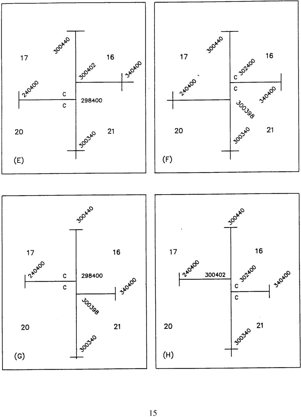
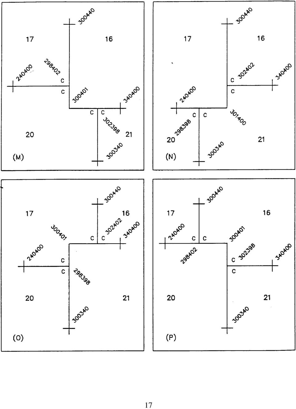
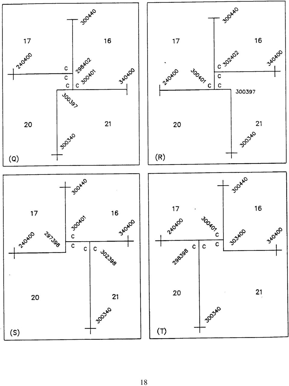
14 Township Interior Point Identifiers Non-Standard Rectangular For double 1/4 section corners (examples A, B, C and D), the corners for the sections to the North and to the West will always have the standard point identifier, this includes all other aliquot part corners in this situation. In examples A and B, the non-standard and standard point identifiers begin at and must progress sequentially to (i.e., A , , etc.). Likewise, examples C and D must progress from to (i.e., D , , etc.). In double section corner situations (examples E through L), the closing corner would be given the non-standard number. To develop the point identifier for triple section corners, and any other situation not shown here, keep in mind that the graphics program will look at each line, either N-S or E-W, as a whole. For example, in building the E and W 400 line, the program will first look at the last three digits of the point identifiers. Any it finds that are within the value of 2 from the nominal 400 (i.e., 398, 399, 400, 401 and 402) will be captured and placed in a file. The program will then sequence the contents of the file 13
.")
15 according to the numerical order of the first three digits of the point identifier. The resulting file then defines which points the E-W line will connect through. For a N and S example, look at the 300 line. The program will first look at the first three digits of the point identifiers, any numbers that are within the value of 2 from the nominal 300 (i.e., 298, 299, 300, 301 and 302) will be captured and placed in a file. The program will then sequence the contents of the file according to the numerical order of the last three digits of the point identifier. The resulting file then defines to which points the N and S line will connect. There is one very important rule to remember when constructing the non-standard point identifiers, as shown in examples Q and R, point should not be picked up during the E-W capture phase, that is why the last three digits are beyond the value of 2 from the nominal 400. In example S, point will not be picked up in the N-S capture phase, and in example T, point will not be picked up in the N-S capture phase. For most situations, sequential numbering will provide the solution. The point identifier, a six-digit number, is constructed of two three-digit sets. The first three digits pertain to the East and West direction only, and must progress from the West boundary of the township in ever increasing values to the East boundary of the township. The second three digits of the point identifier pertain to the North and South direction only, and must progress from the South boundary of the township in ever increasing values to the North boundary of the township. 14

16 15
17 16

18 17
19 18
20 19

21 ELONGATED SECTIONS The attached sketches showing point identifier numbering for elongated sections are to be reviewed and, of course, are subject to change. The intent was to keep the method as simple as possible and to allow the maximum automatic processes to occur. 20
22 21
23 22
24 23
25 SPECIAL SURVEY POINT IDENTIFIERS The prefixes 703 to 999 are to be used for identifying special survey conditions such as Meanders, Mineral surveys, Donation Land Claims (DLC), Homestead Entry Surveys (HES), Tracts, or any other metes and bounds type of surveys. The Oregon State Office generally uses the 800 to 899 prefixes for most special surveys, DLC and Tract numbering on Cadastral Survey plats begin with the number 37 (continuing after section 36). We try to follow this scheme as strictly as we can, however, there are cases where there will be a DLC #37 and a Tract 37 in the same township, and of course there may be situations where there are miles and miles of river meanders, with 60 DLC s, and 10 Tracts, all in the same township. If you are uncertain which point ID S are for which survey, a telephone call to this office can quickly clear it up. The suffix portion of the Special Survey Point Identifiers will generally follow the existing corner numbers on the plats of record, if they were numbered. If not, then we usually start at the most north-easterly corner of the survey and number consecutively clockwise around the survey, with the major angle points being numbered xxx0l0, xxx020, etc. The trailing 0 allows for additional points, such as intersections that define lots, to be added, at least up to the number 9 (xxx019). In those townships where there are special surveys you will find that there are points with different point ID S but having the same coordinate values. The duplications are necessary, at this point in time, to achieve the proper graphic depiction of the surveys of record. 24
Basic Rectangular Surveys
 Basic Rectangular Surveys The Public Land Survey System What Are We Going To Talk About? The rectangular survey system How it is designed How the surveys were supposed to be performed Some unique aspects
STATE OF ALASKA DEPARTMENT OF NATURAL RESOURCES DIVISION OF MINING, LAND AND WATER. GENERAL SURVEY INSTRUCTIONS EASEMENTS Authority 11 AAC 53
 STATE OF ALASKA DEPARTMENT OF NATURAL RESOURCES DIVISION OF MINING, LAND AND WATER GENERAL SURVEY INSTRUCTIONS EASEMENTS Authority 11 AAC 53 These instructions define the survey and platting criteria unique
CHAPTER 8 - LAND DESCRIPTIONS
 CHAPTER 8 - LAND DESCRIPTIONS Notes: While the location of land is commonly referred to by street number and city, it is necessary to use the legal description in the preparation of those instruments relating
Title 10 DEPARTMENT OF NATURAL RESOURCES Division 35 Land Survey Chapter 1 Cadastral Mapping Standards
 Title 10 DEPARTMENT OF NATURAL RESOURCES Division 35 Land Survey Chapter 1 Cadastral Mapping Standards 10 CSR 35-1.010 Application of Standards PURPOSE: These minimum standards provide the digital mapper
ELEMENTS OF SURVEYING FOR CADASTRAL MAPPING
 ELEMENTS OF SURVEYING FOR CADASTRAL MAPPING Chapter 4 2015 Cadastral Mapping Manual 4-0 Elements of Surveying and Mapping Utah's system of land surveying is the rectangular survey system as set forth on
CHAPTER 4 LEGAL DESCRIPTION OF LAND DESCRIBING LAND METHODS OF DESCRIBING REAL ESTATE
 r CHAPTER 4 LEGAL DESCRIPTION OF LAND DESCRIBING LAND A legal description is a detailed way of describing a parcel of land for documents such as deeds and mortgages that will be accepted in a court of
Modern Real Estate Practice in Illinois, 6 th Edition Filmore W. Galaty, Wellington J. Allaway, Robert C. Kyle Laurie MacDougal, Consulting Editor
 Filmore W. Galaty, Wellington J. Allaway, Robert C. Kyle Laurie MacDougal, Consulting Editor Chapter 9 Review Quiz 1. The numbering of sections in a township begins in the section in the a. northeast corner
Weekend Cabin Retreat Project Site Plans
 Weekend Cabin Retreat Project Site Plans Sacramento City College EDT 300/ENGR 306 EDT 300/ENGR 306 - Site Plans 1 Cabin Project Site Plan/Bubble Diagram - Assignment 1 =10-0 Floor Plan - Assignment 1/4
Part 5 U.S. Public Land Survey System
 National Mapping Program Technical Instructions Part 5 U.S. Public Land Survey System Standards for 1:24,000-Scale Digital Line Graphs-3 Core U.S. Department of the Interior U.S. Geological Survey National
Chapter 9 Questions Legal Descriptions
 Chapter 9 Questions Legal Descriptions 1. How many acres are in a lot that is 1/4 of a mile wide by 1/4 of a mile long? a. 10 b. 120 c. 40 d. 80 2. The numbering of sections in a township begins in the
MINIMUM STANDARDS OF ACCURACY, CONTENT AND CERTIFICATION FOR SURVEYS AND MAPS ARTICLE I. TYPES OF SURVEYS
 MINIMUM STANDARDS OF ACCURACY, CONTENT AND CERTIFICATION FOR SURVEYS AND MAPS ARTICLE I. TYPES OF SURVEYS Current with material published in Conn.L.J. through 5/13/08 Sec. 20-300b-1. General There are
Searching Land Records thru the BLM General Land Office Records.
 Searching Land Records thru the BLM General Land Office Records. Land Records can be an exciting addition to your family history search. The United States Government transferred ownership of land to millions
SUR 360, PUBLIC LAND SURVEY SYSTEM Great Basin College, Fall 2012 Course Syllabus August 15, 2012
 SUR 360, PUBLIC LAND SURVEY SYSTEM Great Basin College, Fall 2012 Course Syllabus August 15, 2012 Instructor: Steve Parrish, PLS Reno, NV Office hours: Email to set appointment Home: 775-852-9331 (eve)
Chapter 7: Land Descriptions
 Chapter 7: Land Descriptions 7. Land Descriptions An * in the left margin indicates a change in the statute, rule or text since the last publication of the manual. I. Introduction While the location of
Legal Description Conundrums
 Legal Description Conundrums Robert L. Russell, Russell Law Office Fergus Falls, MN [email protected] 218-998-6400 Dennis Pederson, L.S., Bogart Pederson & Assoc., Inc. Becker, MN [email protected]
U.S. PUBLIC LAND SURVEY SYSTEM
 UNIT 12 U.S. PUBLIC LAND SURVEY SYSTEM Jim McCavitt, PLS Bureau of Land Management Introduction The United States Public Land Survey System (PLSS) began with the Land Ordinance of 1785. The ordinance provided
Land measurement and survey
 Land measurement and survey an introduction for woodland owners J. J. Holmberg relate to most areas of forest management. Knowing how land is measured and how to use maps and surveys is a necessary part
UTM Zones for the US UTM UTM. Uniform strips Scalable coordinates
 UTM UTM Uniform strips Scalable coordinates Globally consistent, most popular projection/coordinate system for regional to global scale geospatial data (i.e. satellite images global scale datasets USGS/EDC)
Finding Real Property: Legal Descriptions
 Finding Real Property: Legal Descriptions LEARNING OBJECTIVES Upon completion of this chapter, the student should be able to: Explain the importance of an accurate legal description. Relate the three methods
Understanding Land Measurement and Legal Descriptions
 Lesson A2 1 Understanding Land Measurement and Legal Descriptions Unit A. Mechanical Systems and Technology Problem Area 2. Soil and Environmental Technology Systems Lesson 1. Understanding Land Measurement
Legal Descriptions. Chapter 9
 Legal Descriptions Chapter 9 Legal Description Defined A description of land is legally sufficient if it allows a competent surveyor to locate the parcel. This means locate and define boundaries 2 When
GEOGRAPHIC INFORMATION SYSTEMS
 GIS GEOGRAPHIC INFORMATION SYSTEMS FOR CADASTRAL MAPPING Chapter 7 2015 Cadastral Mapping Manual 7-0 GIS - GEOGRAPHIC INFORMATION SYSTEMS What is GIS For a long time people have sketched, drawn and studied
Adjusting GIS Data to the GCDB
 Best Practice Recommendations Adjusting GIS Data to the GCDB Montana Base Map Service Center August 2008 This document was prepared for the State of Montana GIS Base Map Service Center, by DJ&A, P.C. in
www.pdhcenter.com PDH Course L118 www.pdhonline.org Basic Public Lands Jan Van Sickle, PLS
 Basic Public Lands Jan Van Sickle, PLS From the very beginning of the Public Land Surveying System it has always been the policy of the Federal Government that land in the public domain must be surveyed
Introduction to Mapping for Assessors
 Introduction to Mapping for Assessors May 2011 PTAX 1-M (R-05/11) Course 1-M Outline Introduction to Mapping for Assessors This course is designed to provide a basic working knowledge of mapping for the
Maps A Primer for Content & Production of Topographic Base Maps For Design Presented by SurvBase, LLC
 Maps A Primer for Content & Production of Topographic Base Maps For Design Presented by Definition and Purpose of, Map: a representation of the whole or a part of an area. Maps serve a wide range of purposes.
Basics of rectangular survey platting Platting one owner s land (fictional)
") Understanding Land Records: Introduction to Land Platting Agenda: 8:30am 9:45am 10:15am 11:30am 1:00pm 2:15pm Introduction Basics of rectangular survey platting Platting one owner s land (fictional) Platting
Understanding Land Records: Introduction to Land Platting Agenda: 8:30am 9:45am 10:15am 11:30am 1:00pm 2:15pm Introduction Basics of rectangular survey platting Platting one owner s land (fictional) Platting
Utah State General Records Retention Schedule SCHEDULE 1 GEOSPATIAL DATA SETS
 Utah State General Records Retention Schedule SCHEDULE 1 BIOTA RECORDS (Item 1-26) These are geospatial records that depict wildlife use areas in the state of Utah as determined by wildlife biologists
LAND SURVEYING PROGRAM QUESTIONS AND ANSWERS
 LAND SURVEYING PROGRAM QUESTIONS AND ANSWERS Written by Dennis J. Mouland, P.L.S., Regional Surveyor Southwest Region Originally compiled by Joan L. Fritz, Land Surveys, Idaho Panhandle National Forest
TRANSFER AND CONVEYANCE STANDARDS OF THE FRANKLIN COUNTY AUDITOR AND THE FRANKLIN COUNTY ENGINEER AS ADOPTED UNDER OHIO REVISED CODE SECTION 319.
 TRANSFER AND CONVEYANCE STANDARDS OF THE FRANKLIN COUNTY AUDITOR AND THE FRANKLIN COUNTY ENGINEER AS ADOPTED UNDER OHIO REVISED CODE SECTION 319.203 EFFECTIVE JULY 1, 1996 AMENDED JULY 14, 1997 AMENDED
About Fact Sheets Contact Us Partners Products Site Map FAQ Help
 About Fact Sheets Contact Us Partners Products Site Map FAQ Help Home Articles PLSS Article The Public Land Survey System (PLSS) What is the PLSS? History Commonly Used Terms Related Links What is the
PART 6 MAPPING CHAPTER 1 ASSESSMENT MAPPING PARCELING STANDARDS AND ASSESSMENT PROCEDURES MANUAL. DEPARTMENT OF REVENUE Property Tax Division
 Parceling Stards PART 6 MAPPING CHAPTER 1 ASSESSMENT MAPPING AND PARCELING STANDARDS 6.1.1 Parceling Stards INTRODUCTION As computerized mapping has moved into the mainstream, the sharing of geographic
GEOGRAPHIC INFORMATION SYSTEMS Lecture 11: Land Division Systems
 GEOGRAPHIC INFORMATION SYSTEMS Lecture 11: Land Division Systems Land Division Systems - in many applications of GIS, land ownership is an important data layer and it is important for GIS users to be familiar
Public Land Survey System - Definition
 Public Land Survey System - Definition The Public Land Survey System (PLSS) is a method used in the United States to locate and identify land, particularly for titles and deeds of farm or rural land. The
Survey Ties Guidelines
 North Carolina Board of Examiners for Engineers and Surveyors Survey Ties Guidelines The North Carolina Board of Examiners for Engineers and Surveyors is providing this document to serve as an interpretative
Mapping & Agricultural Manual
 State of Wyoming Department of Revenue 122 West 25th Street Cheyenne, Wyoming 82002-0110 Foreword The increasing need for land information, at all levels of government and in the private sector, has resulted
Oregon Cadastral Map System
 Chapter 4 Oregon Cadastral Map System Purpose The primary purpose of the Oregon Cadastral Map System is to discover, identify, and inventory all real property within the state of Oregon. A joint effort
PART VI: BOUNDARY SURVEYING
 PART VI: BOUNDARY SURVEYING 6.1 The U.S. Rectangular Survey System (Overview) The Public Land Survey System in Michigan is referenced to two axes. The North and South axis is the Michigan Principal Meridian
Ontario Bar Association Professional Development. Boundaries: Land Surveyors Tell You Where You Are. Public Protection Measures and Practices
 Ontario Bar Association Professional Development Boundaries: Land Surveyors Tell You Where You Are Public Protection Measures and Practices Principle Object of AOLS The principal object of the Association
CHAPTER 9 SURVEYING TERMS AND ABBREVIATIONS
 CHAPTER 9 SURVEYING TERMS AND ABBREVIATIONS Surveying Terms 9-2 Standard Abbreviations 9-6 9-1 A) SURVEYING TERMS Accuracy - The degree of conformity with a standard, or the degree of perfection attained
Tax Parcel Mapping. Visual Representations of Legal Descriptions and So Much More
 Tax Parcel Mapping Visual Representations of Legal Descriptions and So Much More Topics I. E-Distribution II. GIS & Tax Mapping III. Tax Mapping Procedures IV. Deeds, Property Descriptions, & You! I. E-Distribution
Il.oma. s lv,lfo... csl P«.pid B... t..f. Gco. s".,!it. 2 t-+----rt .141, ..:Ioia"~n '60. f7hil,~~ fc'lhe.r; {r; ZIIO
 Il.oma. s lv,lfo... csl P«.pid B... t..f Gco. s".,!it 2 t-+----rt go.141,..:ioia"~n '60 f7hil,~~ fc'lhe.r; {r; ZIIO A DEQUATE legal descriptions are essential in many types of legal J-\... instruments
GEOGRAPHIC INFORMATION SYSTEMS
 GIS GEOGRAPHIC INFORMATION SYSTEMS FOR CADASTRAL MAPPING Chapter 6 2015 Cadastral Mapping Manual 6-0 GIS - GEOGRAPHIC INFORMATION SYSTEMS What is GIS For a long time people have sketched, drawn and studied
Topographic Maps Practice Questions and Answers Revised October 2007
 Topographic Maps Practice Questions and Answers Revised October 2007 1. In the illustration shown below what navigational features are represented by A, B, and C? Note that A is a critical city in defining
FORMULA FOR FINDING THE SQUARE FEET OF A RECTANGLE L x W = A
 UNIT I REAL ESTATE MATH AREA MEASUREMENTS FORMULA FOR FINDING THE SQUARE FEET OF A RECTANGLE L x W = A Where: A = Area L = Length W = Width If the length = 30 and the width = 20 20 x 30 = 600 Sq. Feet
* Note: a cadastral system is the complete coverage of a country for purposes like taxation, whereas a land registration system is exclusively
 http://www.nationalstep.org/images/satellite_globe.jpg LAND ADMINISTRATION http://www.sdnhm.org/exhibits/minerals/ima ges/flu-2.jpg http://www.nsf.gov/od/lpa/news/ 02/images/lake.jpg www.redlionstencils.com
Standard on Digital Cadastral Maps and Parcel Identifiers
 Standard on Digital Cadastral Maps and Parcel Identifiers APPROVED JULY 2003 INTERNATIONAL ASSOCIATION OF ASSESSING OFFICERS 1. Scope This standard provides recommendations on the development and maintenance
Mastering U.S. LEGAL DESCRIPTIONS
 www.landtraining.net Mastering U.S. LEGAL DESCRIPTIONS This FREE Webinar is offered by Midland College in collaboration with Alyce Hoge of Land Training. Alyce Hoge is the instructor for the Midland College
G.S. 47-30 Mapping Requirements for Recordable Maps
 G.S. 47-30 Mapping Requirements for Recordable Maps 47-30. Plats and subdivisions; mapping requirements. (a) Size Requirements. All land plats presented to the register of deeds for recording in the registry
AUTOMATION OF FLOOD HAZARD MAPPING BY THE FEDERAL EMERGENCY MANAGEMENT AGENCY ABSTRACT INTRODUCTION
 AUTOMATION OF FLOOD HAZARD MAPPING BY THE FEDERAL EMERGENCY MANAGEMENT AGENCY Daniel M. Cotter Federal Emergency Management Agency Federal Insurance Administration Office of Risk Assessment 500 C Street,
Brevard County Public Works Finance and Contracts Administration
 Brevard County Public Works Finance and Contracts Administration Public Works Survey & Mapping Division Review Check Sheet for Land Acquisition, Drainage, Roadway and Pedway Expansion, Asbuilts, Maintenance
SERVICES THAT MAY ONLY BE PERFORMED BY A NEW JERSEY PROFESSIONAL LAND SURVEYOR
 SERVICES THAT MAY ONLY BE PERFORMED BY A NEW JERSEY PROFESSIONAL LAND SURVEYOR 1. ANY MAP OR PLAN THAT SHOWS: Property Lines. NJSA 45:8-28(e), NJAC 13:40-1.3, 13:40-5.1 Locations of Existing Buildings
Geospatial Positioning Accuracy Standards Part 3: National Standard for Spatial Data Accuracy
 Subcommittee for Base Cartographic Data Federal Geographic Data Committee Federal Geographic Data Committee Department of Agriculture Department of Commerce Department of Defense Department of Energy Department
Model Virginia Map Accuracy Standards Guideline
 Commonwealth of Virginia Model Virginia Map Accuracy Standards Guideline Virginia Information Technologies Agency (VITA) Publication Version Control Publication Version Control: It is the user's responsibility
PLSS Change Management Process
 PLSS Change Management Process A proposed model for shared responsibilities and resources between CadNSDI data contributors, data custodians and data users Nancy von Meyer, FGDC Cadastral Subcommittee
4.03 Vertical Control Surveys: 4-1
 4. HORIZONTAL AND VERTICAL CONTROL 4.01 General: Sufficient horizontal and, if applicable, vertical control surveys shall be established by the Contractor for all photogrammetric mapping purposes. Prior
THE APPRAISAL OF REAL ESTATE 3 RD CANADIAN EDITION BUSI 330
 THE APPRAISAL OF REAL ESTATE 3 RD CANADIAN EDITION BUSI 330 REVIEW NOTES by CHUCK DUNN CHAPTER 10 Copyright 2010 by the Real Estate Division and Chuck Dunn. All rights reserved ARE 3 rd EDITION REVIEW
STATE AGRICULTURE DEVELOPMENT COMMITTEE FARMLAND PRESERVATION PROGRAM
 STATE AGRICULTURE DEVELOPMENT COMMITTEE FARMLAND PRESERVATION PROGRAM SCOPE OF WORK FOR PROFESSIONAL LAND SURVEYING SERVICES A. REFERENCE TO LAWS: All survey work will be performed in accordance with New
Earth Coordinates & Grid Coordinate Systems
 Earth Coordinates & Grid Coordinate Systems How do we model the earth? Datums Datums mathematically describe the surface of the Earth. Accounts for mean sea level, topography, and gravity models. Projections
LEGAL DESCRIPTIONS INTRODUCTION
 LEGAL DESCRIPTIONS INTRODUCTION Legal descriptions, as the name implies, are the way and means by which real property, or real estate, is legally identified, conveyed, assessed and taxed. To put this into
History of Government Land Ownership Survey Systems Land Information GIS and Mapping Oil & Gas Issues Legal Issues Version 7.2
 Introduction to Land Information History of Government Land Ownership Survey Systems Land Information GIS and Mapping Oil & Gas Issues Legal Issues Version 7.2 Table of Contents Topic Page History: History
Visualizing Metes and Bounds Property Descriptions on Google Maps and Google Earth
 Visualizing Metes and Bounds Property Descriptions on Google Maps and Google Earth Presented by James L. Tanner Genealogy's Star http://genealogysstar.blogspot.com New online tools allow you to identify
WHAT YOU NEED TO USE THE STATE PLANE COORDINATE SYSTEMS
 WHAT YOU NEED TO USE THE STATE PLANE COORDINATE SYSTEMS N & E State Plane Coordinates for Control Points AZIMUTHS - True, Geodetic, or Grid - Conversion from Astronomic to Geodetic (LaPlace Correction)
CHAPTER 7 TRAVERSE Section I. SELECTION OF TRAVERSE DEFINITION
 CHAPTER 7 TRAVERSE Section I. SELECTION OF TRAVERSE DEFINITION A traverse is a series of straight lines called traverse legs. The surveyor uses them to connect a series of selected points called traverse
State. Surveying Regulations. A list of national surveying regulations as of January 2012
 State 2012 Surveying Regulations A list of national surveying regulations as of January 2012 Table of Contents Alabama... 4 Alaska... 4 Arizona... 5 Arkansas... 5 California... 6 Colorado... 7 Connecticut...
NSPS SURVEY TECHNICIAN CERTIFICATION PROGRAM LEVEL III SAMPLE EXAMINATION QUESTIONS
 NSPS SURVEY TECHNICIAN CERTIFICATION PROGRAM LEVEL III SAMPLE EXAMINATION QUESTIONS NATIONAL SOCIETY OF PROFESSIONAL SURVEYORS October 2007 This booklet has been prepared to provide an example of what
If you require assistance in obtaining access to the presentations or have questions regarding the. 6300 or Glenn Young at (916) 341 6696.
 341 6696.") These materials were developed by CalRecycle staff to address specific technical training areas and are posted as reference documents for the local l government and CalRecycle staff who work on closed,
These materials were developed by CalRecycle staff to address specific technical training areas and are posted as reference documents for the local l government and CalRecycle staff who work on closed,
Introduction to U.S. Land Records
 Introduction to U.S. Land Records INTRODUCTION Land records are not a perfect genealogical source. That is because they are not filled with birth dates or places, names of parents, etc. As a record group
PROCEDURAL AND TECHNICAL STANDARDS For The Practice of Land Surveying In The State of Rhode Island And Providence Plantations
 PROCEDURAL AND TECHNICAL STANDARDS For The Practice of Land Surveying In The State of Rhode Island And Providence Plantations Prepared By The Rhode Island Society of Professional Land Surveyors Inc. and
5. It is provided that resurveys may be made by the Government under certain conditions.
 LAWS RELATING TO PUBLIC-LAND SURVEYS Beginning with an ordinance passed by the Continental Congress in May, 1785 (which provided for townships 6 miles square, each containing 36 sections 1 mile square),
Lesson 2: The Nature of Real Property. Real Property. Real Property. Real Estate Principles of Georgia. vs. Personal Property.
 Real Estate Principles of Georgia Lesson 2: The Nature of Real Property 1 of 53 23 Real Property vs. Personal Property Two types of property: Real property, ( realty ), real estate Personal property (
Metes and Bounds Help
 Metes and Bounds Help Topics: Drawing Wizard Data Entry o Entering Metes and Bounds Data o Entering Section Call Data Layers o Layer Options o Analyze Layer Closing Error Tabs Drawing Options o Drawing
SECOND GRADE 1 WEEK LESSON PLANS AND ACTIVITIES
 SECOND GRADE 1 WEEK LESSON PLANS AND ACTIVITIES UNIVERSE CYCLE OVERVIEW OF SECOND GRADE UNIVERSE WEEK 1. PRE: Discovering stars. LAB: Analyzing the geometric pattern of constellations. POST: Exploring
2003 Acoma/Laguna Irrigation Water Use Survey
 2003 Prepared for: Prepared by: United States Department of Interior Keller-Bliesner Engineering LLC Bureau of Indian Affairs Logan, Utah Albuquerque Area Office February 17, 2003 and United States Department
Reporting Thailand Cadastral System in Cadastre 2014 Trends
 Reporting Thailand Cadastral System in Cadastre 2014 Trends Vuttinan UTESNAN, Thailand Key words: cadastre2014, land registration, title, digital mapping SUMMARY Cadastral System is defined to the limit
The Map Grid of Australia 1994 A Simplified Computational Manual
 The Map Grid of Australia 1994 A Simplified Computational Manual The Map Grid of Australia 1994 A Simplified Computational Manual 'What's the good of Mercator's North Poles and Equators, Tropics, Zones
STATE OF NEVADA Department of Administration Division of Human Resource Management CLASS SPECIFICATION
 STATE OF NEVADA Department of Administration Division of Human Resource Management CLASS SPECIFICATION TITLE PHOTOGRAMMETRIST/CARTOGRAPHER V 39 6.102 PHOTOGRAMMETRIST/CARTOGRAPHER II 33 6.110 PHOTOGRAMMETRIST/CARTOGRAPHER
Analysis One Code Desc. Transaction Amount. Fiscal Period
 Analysis One Code Desc Transaction Amount Fiscal Period 57.63 Oct-12 12.13 Oct-12-38.90 Oct-12-773.00 Oct-12-800.00 Oct-12-187.00 Oct-12-82.00 Oct-12-82.00 Oct-12-110.00 Oct-12-1115.25 Oct-12-71.00 Oct-12-41.00
Appendix E FAA ALP Sheet Checklist
 Appendix E FAA ALP Sheet Checklist AC 150/5070-6B (incl. Chg. 1, 5/1/07) Airport Layout Plan Drawing Set The following list provides general guidelines in preparing the Airport Layout Plan set. The individual
Chapter 4: How To Do A Title Search
 Chapter 4: How To Do A Title Search Introduction Title searching answers questions about property ownership, sale prices, mortgages, liens, and court cases. Although a "how to" narrative cannot replace
delorme.com/earthmate Earthmate A Guide to the Complete GPS Navigation Solution for Smartphones and Tablets.
 delorme.com/earthmate Earthmate A Guide to the Complete GPS Navigation Solution for Smartphones and Tablets. EARTHMATE I N C L U D E D A guide to Earthmate Hunt Edition is included in this document. Earthmate
GIS User Guide. for the. County of Calaveras
 GIS User Guide for the County of Calaveras Written by Dave Pastizzo GIS Coordinator Calaveras County San Andreas, California August 2000 Table of Contents Introduction..1 The Vision.1 Roles and Responsibilities...1
Standard Surveying Terms
 Standard Surveying Terms Aliquot - The description of fractional section ownership used in the U.S. public land states. A parcel is generally identified by its section, township, and range. The aliquot
Kootenai County Plats & Condos County Surveyor Review Policies & Procedures
 Kootenai County Plats & Condos County Surveyor Review Policies & Procedures All plats are submitted to the county Planning Department, with the appropriate fees for the survey phase of the review. The
THE PUBLIC LAND SURVEY SYSTEM FOR THE CADASTRAL MAPPER
 THE PUBLIC LAND SURVEY SYSTEM FOR THE CADASTRAL MAPPER FLORIDA ASSOCIATION OF CADASTRAL MAPPERS In conjunction with THE FLORIDA DEPARTMENT OF REVENUE Proudly Presents COURSE 2 THE PUBLIC LAND SURVEY SYSTEM
Chapter 29. Minimum Standards of Practice for Property Boundary Surveys
 Chapter 29. Minimum Standards of Practice for Property Boundary Surveys 2901. General Scope and Purpose A. The following minimum standards of practice for land surveying in the state of Louisiana have