Introduction to U.S. Land Records
|
|
|
- Benjamin Sanders
- 10 years ago
- Views:
Transcription
1 Introduction to U.S. Land Records INTRODUCTION Land records are not a perfect genealogical source. That is because they are not filled with birth dates or places, names of parents, etc. As a record group however, they comprise one of the most important sources for genealogical research in America. Why? WHY SEARCH LAND RECORDS Land records exist from the earliest colonial period, dating to the first permanent settlements in America. Their value far exceeds their otherwise ordinary content because they date from a period in history when there are few other records. Prior to 1850, nine out of ten adult white males in America owned land. Any record group that includes such a large part of the population has to be considered important. Land records leave a trail which genealogists can follow. County-wide indexes exist to virtually every land owner in America since the early 1600s. Land records are solid proof of where your ancestor lived at a specific time. Because of their importance to families and government, land purchases were recorded as soon as possible and tend to survive catastrophes when other records don t. Individuals named together in deeds are often related. Land records may provide clues identifying where your ancestor came from or where they moved to. Land records may provide important information about your ancestor not found in any other records. Land records can provide enough detail to separate the identities of individuals having the same name and living in the same county. This is one method for solving a recurring problem in genealogy research. TYPES OF LAND TRANSACTIONS There are two major types of land transactions in the United States. First are transactions between a government entity and an individual or party, called First Purchase transactions. Second are transactions between two individuals or parties, called Person-to-Person transactions. LAND SURVEY SYSTEMS There are two major systems used in the United States for surveying land. They are: Metes and Bounds Survey System: The first system used in the original 13 Colonies. This type of land survey is based on English Common law and uses running descriptions with measures of angles and distances (metes) and definite boundary markers (bounds) such as natural land features, including trees and streams, as well as adjoining property lines to describe plots of land. Today, iron pins and stakes are used to mark boundaries. Starting at a Point of Beginning (POB), the description runs clockwise or counterclockwise around the perimeter using directions or bearings and distances, or calls for bounds. The description leads back to the POB and usually includes an area expressed in acres or square feet. A metes and bounds description often includes reference to a survey plat. Public Land Survey System (PLSS): Also known as the Rectangular Survey System has been used in the United States for the survey of public lands since the Land Ordinance Act of Its basic units of area are the Township and Section. For a more detailed description, refer to one of the resources listed under Additional Resources. USEFUL TERMS Aliquot Part: The standard subdivisions of a section, such as a half section, quarter section, or quarter-quarter section. Base Line: A parallel of latitude, or approximately a parallel of latitude, running through an arbitrary point chosen as the starting point for all sectionalized land within a given area. Cadastral: Having to do with the boundaries of land parcels. Cash Sale: Federal land purchased with cash. Conveyance: Synonymous with deed. Deed: A signed and usually sealed instrument by which title in real property is transferred from one party to another. Also evidence of a person s legal ownership. There are various types of Deeds. Dower: The lands and tenements to which a widow has claim, in life estate, after the death of her husband, for the support of herself and her children. Under English common law this was one-third the value of all lands which her husband owned in fee simple at any time during their marriage. Even though a wife could not own land in Page 1

2 Introduction to U.S. Land Records her own name, she could veto the sale of land in which she held rights. Et al: Abbreviation for the Latin term referring to a number of people. et alii masculine plural, et aliae feminine plural, or et alia neuter plural. Et ux: Abbreviation for the Latin term et uxor meaning and his wife. First Purchase: A transaction happens when land is first purchased from a government or other entity, such as the federal government, a State or Colonial government, or a foreign monarchy. Before an individual could make such a purchase, a survey of the land had to occur. Government Lot: In the PLSS system, a subpart of a section which is not described as an aliquot part of the Section, but which is designated by number, for example, Lot 3. A lot may be regular or irregular in shape, and its acreage may vary from that of regular aliquot parts. These lots frequently border water areas excluded from the PLSS. Grant: When a government, under English Common law, gives land to an individual. Grantee: Person or entities buying land. Grantor: Person or entities selling land. Homestead: A piece of land given to an individual(s) upon meeting predetermined requirements. Indenture: See Deed. Formerly a deed drawn up in two or more parts according to the number of parties, which were separated by cutting in a curved or indented line known as the chirography, for identification and security. Initial Point: In the PLSS system, the starting point for a survey of public lands. Land Grant: A land grant is an area of land to which title was conferred by a predecessor government and confirmed by the U.S Government after the territory in which it is situated was acquired by the United States. These lands were never part of the original public domain and were not subject to subdivision by the PLSS. Land Patent: See Patent. Letters Patent: See Patent. Lot: See Government Lot. Patent: Also known as first-title deeds or final certificates. A document issued by the government giving an individual title to a tract of land. In the United States, all land can be traced back to the respective land patent, to first title deed and to claims that document titles for land originally owned by France, Spain, United Kingdom, Mexico, Russia, or native Americans. Principal Meridian: In the PLSS system, a meridian line running through an arbitrary point chosen as a starting point for all sectionalized land within a given area. Public Domain: Land owned by the Federal government for the benefit of the citizens. The original public domain included the lands that were turned over to the Federal Government by the Colonial States and the areas acquired later from the native Indians or foreign powers. Sometimes used interchangeably with Public lands. Public Lands: Lands in public ownership, therefore owned by the Federal government. Sometimes used interchangeably with Public domain. Quitclaim Deed: An instrument by which a person releases all title, or claim which he may possess in certain real properties without making any warrants thereto. Range: In the PLSS survey system, a vertical column of townships. Release of Dower: The release of a wife s claim to the land being sold. Section: In the PLSS system, a one-square-mile parcel of land, containing 640 acres, or approximately one thirtysixth of a township. Due to the curvature of the Earth, sections may occasionally be slightly smaller than one square mile. Township: In the PLSS system, an approximately 6-mile square area of land, containing 36 sections. Also, a horizontal row of townships. Warranty Deed: An instrument by which the grantor warrants, by covenant, the title of the property he sells; and should the title become faulty because of paramount claims against it, or for any other reason, the grantor, or his heirs, may be sued on the warranty. This is perhaps the most important and common type of deed. HOW DEEDS ARE STRUCTURED Typical information contained in deeds include the following: Names and residences of the grantor(s) and grantee(s). Consideration or cost. Legal description, which precisely identifies the location of the land. Deeds using the metes and bounds system also include names of abutting neighbors. Date the instrument was created. Date the instrument was recorded by the county. Additional useful information sometimes contained in deeds include: Page 2

3 Introduction to U.S. Land Records Names of spouses of grantor(s) and grantee(s). Names of witnesses. Hairs and other relatives may be named as selling land together. Names of neighbors. Alternate residences. Occupation or other identifying information. REPOSITORIES OF LAND RECORDS Federal Land Records: Copies of the records were filed with the General Land Office who later transferred them to the National Archives. The records were compiled by NARA into a document series titled Land Entry Case Files and include transactions such as; Bounty Land Warrants, Preemption, Cash Entry Sales, Homesteads, etc. General Land Office records may be searched online at the Bureau of Land Management s website given below under internet resources. Federal land transactions were also recorded at the county level. County Land Records: Land transactions between individuals are typically recorded in deed books. The original deed was retained by the land owner, but a full copy of the deed was recorded by the county clerk. Deed books are kept at the county level for most U.S. states, though in some areas they may be kept at the city or town level, principally on the East coast. The county-equivalent in Alaska is known as a district, and in Louisiana, as a parish. ADDITIONAL RESOURCES Printed Resources: Eichholz, Alice, Red Book American State, County, and Town Sources, 3rd ed. Salt Lake City: Ancestry, Everton, George B., The Handybook for Genealogists: United States of America, 10th ed., Draper, Utah: Everton Publishers, Garner, Bryan A. editor in chief, Black s Law Dictionary, 9th ed. St. Paul, Minn.: Thompson West, 2009 Greenwood, Val D., The Researcher s Guide to American Genealogy, 3rd ed., Baltimore, MD: Genealogical Publishing Co., Szucs, Loretto Dennis, and Sandra Hargreaves Luebking, The Source: A Guidebook to American Genealogy, 3rd ed. Salt Lake City: Ancestry, Internet Resources: wiki.familysearch.org: search for United States Land and Property. includes an index to public land transfers from the federal government, including homesteads, cash entry, and others. Digital images are available for many records. includes county land records contained in the collection of the Family History Library of the Church of Jesus Christ of Latter-Day Saints. Digital images of many records are available. All digital images of records may be browed online, not all records are indexed. Page 3

4 NOTES Introduction to U.S. Land Records Page 4

5 USEFUL LAND MEASUREMENTS 1 Link = 7.92 Inches 1 Rod = 16.5 Feet 1 Pole = 1 Rod 1 Chain = 66 Feet 1 Furlong = 40 Rods or 10 Chains 1 Mile = 5,280 Feet or 320 Rods or 80 Chains Introduction to U.S. Land Records PUBLIC LAND SURVEY SYSTEM (PLSS) Aliquot Parts of a Section One Section contains 640 acres Page 5
 Aliquot Parts of a Section One")
6 Introduction to U.S. Land Records Below is an example of one Township (36 Sections), laid out using the Public Land Survey System. Notice that every parcel of land has been laid out using the aliquot subdivisions of the Section. Atlas of Republic County, Kansas, (Gillen and Davy, Chicago, Illinois, 1884), Kansas Memory.org, digital image, < Kansas Historical Society. Page 6

7 U.S. Land Records: The State Land States Practical Exercises EXERCISE No. 1 In the following Exercise the baseline is oriented parallel to an imaginary North South grid in the same manner as you would place it on a map or grid paper. Measure the angles for lines A through G and express them as surveyor s bearing, such as N 68 S. Line A: Answers To Exercise No 2. Line B: Line A = 60 Poles Line C: Line B = 38 Poles Line D: Line C = 5 Poles Line E: Line D = 22 Poles Line F: Line E = 49 Poles Line G: Page 1

8 U.S. Land Records: The State Land States Practical Exercises EXERCISE No. 2 Measure the lengths of the lines drawn below using the scale of 1:24,000 (1 inch equals 200 feet). Cut out and use the scale provided. Note that this is a handy scale to use when plotting land descriptions because it matches that of the 7.5 minute quadrangle maps available through the United States Geological Survey. Answers To Exercise No 1: Line A: = N 26 E Line B = N 86 E Line C = S 71 E Line D = S 7 E Line E = S 52 W Line F = N 79 W Line G = N 37 W Line A: Line B: Line C: Line D: Line E: Page 2

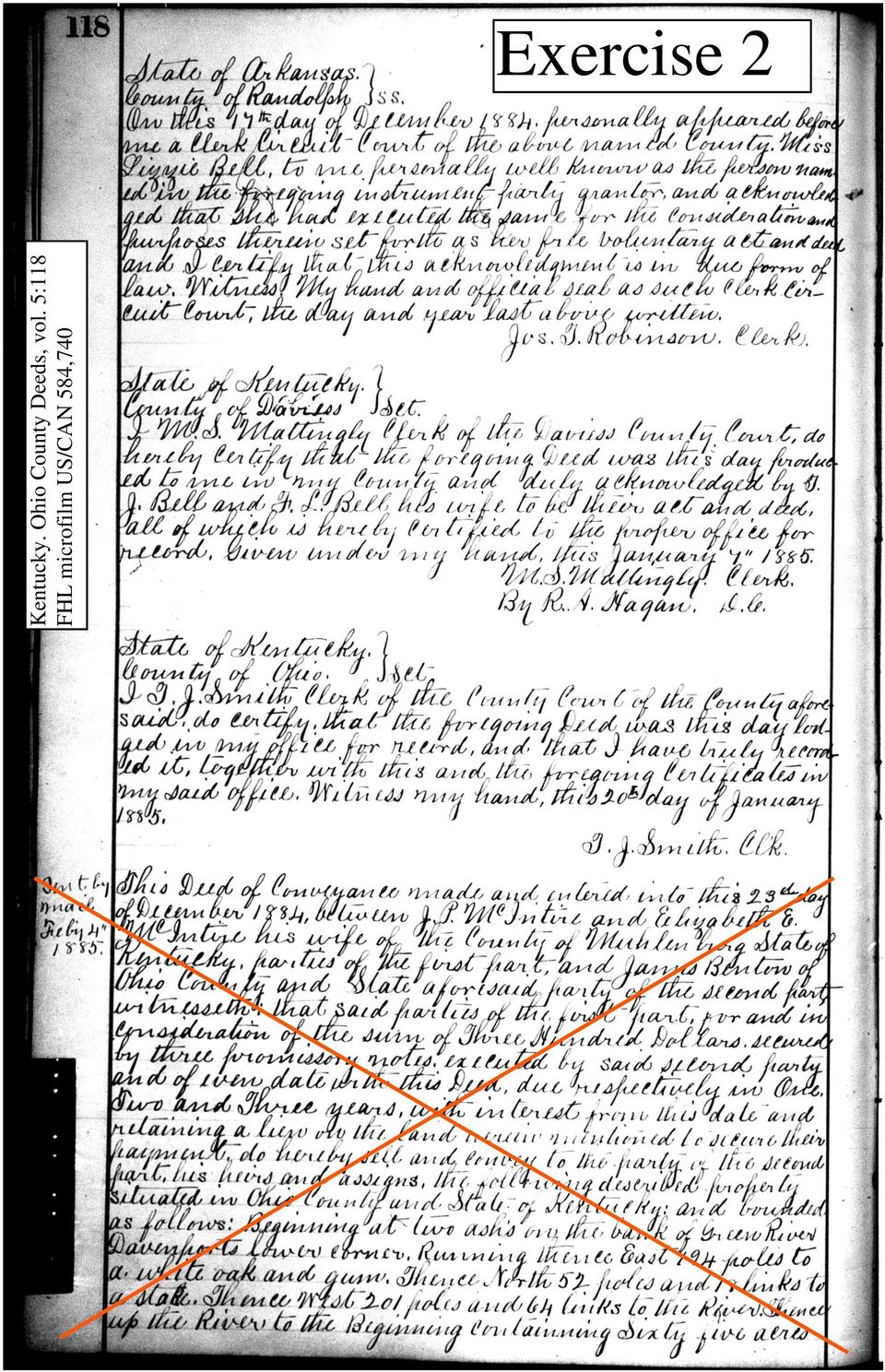
9 U.S. Land Records: The State Land States Practical Exercises EXERCISE 3: The ability to draw plats from legal descriptions is a useful tool to genealogists. In this exercise, your research is focused on a hypothetical ancestor Matthew Dunsmore ( ). Below is a legal description obtained from prior research of land records located at the clerk s office of Middle County, Kentucky, Deeds, vol. 5:118, Jeremiah Hicks to Matthew Dunsmore, recorded 18 February Complete the Worksheet below and plot the tract of land on the graph paper provided. Cut out and use the compass and scale provided. The plat will be drawn at a scale of 1:24,000 or 1 inch equals 200 feet. A certain tract or parcel of land, Beginning at a Spanish Oak and two Black Oaks the northwest corner of a twenty acre tract granted to Samuel Richards thence with said line south sixty two degrees east thirty three poles to a post oak thence continuing with said line south thirteen degrees east twenty four poles to his southwest corner a post oak thence south fifty three degrees west nineteen poles to a Black Oak thence north sixty degrees west thirty six poles to a Hickory thence north forty five degrees east thirteen poles to a post oak thence north forty degrees east twenty one poles to the southeast corner of a twelve acre tract granted to Jesse Richards a post oak thence with said line north sixty six degrees forty three minutes [43 minutes is approximately 3/4 of one degree] seventeen and six tenths poles to the Beginning said parcel or tract of land containing 9.28 acres more or less. Name of Ancestor: LAND RECORD WORKSHEET Source: Point Description Bearing Distance Remarks Answer is on back of this page. Do not look until after you have completed the exercise. Page 3

10 U.S. Land Records: The State Land States Practical Exercises Name of Ancestor: LAND RECORD WORKSHEET Source: Point Description Bearing Distance Remarks 1 Spanish Oak, 2 Black Oaks S 62 E 33 poles Beginning, NW corner of 20-acre tract to Samuel Richards 2 Post S 13 E 24 poles 3 Post S 53 W 19 poles SW corner of Samuel Richards tract 4 Black Oak N 60 W 36 poles 5 Hickory N 45 E 13 poles 6 Post N 40 E 21 poles 7 Post N E 17 poles, 15 links Beginning SE corner of 12-acre tract to Jesse Richards Scale reduced. Page 4

11 Page 5 U.S. Land Records: The State Land States Practical Exercises

12 U.S. Land Records: The State Land States Below are a compass and scale, useful tools for plotting land descriptions. Cut them out for use. The scale is compatible with 7.5 Minute quadrangle maps (1:24,000) published by the United States Geological Survey.
 published by the United")
13 U.S. Land Records: The State Land States Below are a compass and scale, useful tools for plotting land descriptions. Cut them out for use. The scale is compatible with 7.5 Minute quadrangle maps (1:24,000) published by the United States Geological Survey.
 published by the United")
14 U.S. Land Records: Public Land States Practical Exercises Learning to find and analyze the genealogical information contained in land records is important to the research process. The following exercises are designed to help you do that. EXERCISE No. 1 On the drawing of Section 13 below, sketch the following land description. Oregon. Tillamook County Deeds, vol. A:99, recorded 13 Mar 1866 Section 13, Township 1 South, Range 10 West, Tillamook County, Oregon Page 1

15 EXERCISE No. 2 Read the land record handout and fill in the information below. U.S. Land Records: Public Land States Practical Exercises Date Filed: Date Recorded: Type of Instrument: County where property is located: Grantor(s) Residence(s) Grantee(s) Residence(s) Witnesses: Consideration: Land Description: Conclusions: List other sources that can be searched to support conclusions: Page 2
 Residence(s) Grantee(s) Residence(s)")
16

17
18 EXERCISE No. 3 U.S. Land Records: Public Land States Practical Exercises [The information presented below is fictitious and intended for educational purposes only.] Theophilus Jones was born 10 May 1822 in New Jersey, the son of Jeremiah Jones and Mehetabel (maiden name unknown) and died 17 June 1883 in Hoosier County, Indiana. Theophilus married Jemima Smith on 15 July 1845 in Center County, Ohio. Jemima was born about 1826 in Ohio and died 13 Jan 1851 in Center County, Ohio. A search of the 1840 U.S. federal census identified three men enumerated in Center County with the surname Smith having a female age years in the household. Having first obtained the information below from a search of county land records, which Smith would you research first? Jeremiah Jones owned the NE1/4 of the NE1/4 of Sec. 27, T4N, R19E. James Smith owned the N1/2 of Sec. 8, T4N, R19E. Andrew Smith owned the NE1/4 of the NE1/4 of Sec. 30, T4N, R19E. Marshall Smith owned the SW1/4 of the SW1/4 of Sec. 23, T4N, R19E. Use the map of the reverse side to sketch the location of each tract of land. I would begin my search with Smith. Explain why: Page 3

19 U.S. Land Records: Public Land States Practical Exercises Center County, Ohio Township 4 North, Range 19 East (Each Section is 1 mile square) Page 4

About Fact Sheets Contact Us Partners Products Site Map FAQ Help
 About Fact Sheets Contact Us Partners Products Site Map FAQ Help Home Articles PLSS Article The Public Land Survey System (PLSS) What is the PLSS? History Commonly Used Terms Related Links What is the
Public Land Survey System - Definition
 Public Land Survey System - Definition The Public Land Survey System (PLSS) is a method used in the United States to locate and identify land, particularly for titles and deeds of farm or rural land. The
Probably. Land and property records go back further in time than any other type of record. Often before marriage records were preserved by government.
 Probably Land and property records go back further in time than any other type of record. Often before marriage records were preserved by government. They can place your ancestor in a particular place
Mastering U.S. LEGAL DESCRIPTIONS
 www.landtraining.net Mastering U.S. LEGAL DESCRIPTIONS This FREE Webinar is offered by Midland College in collaboration with Alyce Hoge of Land Training. Alyce Hoge is the instructor for the Midland College
Finding Real Property: Legal Descriptions
 Finding Real Property: Legal Descriptions LEARNING OBJECTIVES Upon completion of this chapter, the student should be able to: Explain the importance of an accurate legal description. Relate the three methods
CHAPTER 8 - LAND DESCRIPTIONS
 CHAPTER 8 - LAND DESCRIPTIONS Notes: While the location of land is commonly referred to by street number and city, it is necessary to use the legal description in the preparation of those instruments relating
Legal Descriptions. Chapter 9
 Legal Descriptions Chapter 9 Legal Description Defined A description of land is legally sufficient if it allows a competent surveyor to locate the parcel. This means locate and define boundaries 2 When
Visualizing Metes and Bounds Property Descriptions on Google Maps and Google Earth
 Visualizing Metes and Bounds Property Descriptions on Google Maps and Google Earth Presented by James L. Tanner Genealogy's Star http://genealogysstar.blogspot.com New online tools allow you to identify
CHAPTER 4 LEGAL DESCRIPTION OF LAND DESCRIBING LAND METHODS OF DESCRIBING REAL ESTATE
 r CHAPTER 4 LEGAL DESCRIPTION OF LAND DESCRIBING LAND A legal description is a detailed way of describing a parcel of land for documents such as deeds and mortgages that will be accepted in a court of
Basics of rectangular survey platting Platting one owner s land (fictional)
") Understanding Land Records: Introduction to Land Platting Agenda: 8:30am 9:45am 10:15am 11:30am 1:00pm 2:15pm Introduction Basics of rectangular survey platting Platting one owner s land (fictional) Platting
Understanding Land Records: Introduction to Land Platting Agenda: 8:30am 9:45am 10:15am 11:30am 1:00pm 2:15pm Introduction Basics of rectangular survey platting Platting one owner s land (fictional) Platting
Weekend Cabin Retreat Project Site Plans
 Weekend Cabin Retreat Project Site Plans Sacramento City College EDT 300/ENGR 306 EDT 300/ENGR 306 - Site Plans 1 Cabin Project Site Plan/Bubble Diagram - Assignment 1 =10-0 Floor Plan - Assignment 1/4
Basic Rectangular Surveys
 Basic Rectangular Surveys The Public Land Survey System What Are We Going To Talk About? The rectangular survey system How it is designed How the surveys were supposed to be performed Some unique aspects
Understanding Land Measurement and Legal Descriptions
 Lesson A2 1 Understanding Land Measurement and Legal Descriptions Unit A. Mechanical Systems and Technology Problem Area 2. Soil and Environmental Technology Systems Lesson 1. Understanding Land Measurement
FORMULA FOR FINDING THE SQUARE FEET OF A RECTANGLE L x W = A
 UNIT I REAL ESTATE MATH AREA MEASUREMENTS FORMULA FOR FINDING THE SQUARE FEET OF A RECTANGLE L x W = A Where: A = Area L = Length W = Width If the length = 30 and the width = 20 20 x 30 = 600 Sq. Feet
Chapter 7: Land Descriptions
 Chapter 7: Land Descriptions 7. Land Descriptions An * in the left margin indicates a change in the statute, rule or text since the last publication of the manual. I. Introduction While the location of
Searching Land Records thru the BLM General Land Office Records.
 Searching Land Records thru the BLM General Land Office Records. Land Records can be an exciting addition to your family history search. The United States Government transferred ownership of land to millions
Il.oma. s lv,lfo... csl P«.pid B... t..f. Gco. s".,!it. 2 t-+----rt .141, ..:Ioia"~n '60. f7hil,~~ fc'lhe.r; {r; ZIIO
 Il.oma. s lv,lfo... csl P«.pid B... t..f Gco. s".,!it 2 t-+----rt go.141,..:ioia"~n '60 f7hil,~~ fc'lhe.r; {r; ZIIO A DEQUATE legal descriptions are essential in many types of legal J-\... instruments
Indiana Survey Townships
 Page 46 IN-GENious! The Rectangular Survey System in Indiana and Using the GIS Atlas by Annette Harper You ve found a wonderful deed or land patent and now you d like to pinpoint exactly where your ancestor
GEOGRAPHIC INFORMATION SYSTEMS Lecture 11: Land Division Systems
 GEOGRAPHIC INFORMATION SYSTEMS Lecture 11: Land Division Systems Land Division Systems - in many applications of GIS, land ownership is an important data layer and it is important for GIS users to be familiar
Modern Real Estate Practice in Illinois, 6 th Edition Filmore W. Galaty, Wellington J. Allaway, Robert C. Kyle Laurie MacDougal, Consulting Editor
 Filmore W. Galaty, Wellington J. Allaway, Robert C. Kyle Laurie MacDougal, Consulting Editor Chapter 9 Review Quiz 1. The numbering of sections in a township begins in the section in the a. northeast corner
Lesson 2: The Nature of Real Property. Real Property. Real Property. Real Estate Principles of Georgia. vs. Personal Property.
 Real Estate Principles of Georgia Lesson 2: The Nature of Real Property 1 of 53 23 Real Property vs. Personal Property Two types of property: Real property, ( realty ), real estate Personal property (
Tax Parcel Mapping. Visual Representations of Legal Descriptions and So Much More
 Tax Parcel Mapping Visual Representations of Legal Descriptions and So Much More Topics I. E-Distribution II. GIS & Tax Mapping III. Tax Mapping Procedures IV. Deeds, Property Descriptions, & You! I. E-Distribution
State Land States vs. Public Land States
 Public Lands Survey System Rectangular Survey System Sections, Ranges, Townships Roberta Bobbi King Lakewood, Colorado State Land States vs. Public Land States State Land States: Metes and bounds twenty
Chapter 4: How To Do A Title Search
 Chapter 4: How To Do A Title Search Introduction Title searching answers questions about property ownership, sale prices, mortgages, liens, and court cases. Although a "how to" narrative cannot replace
Research in the Land Entry Files of the General Land Office
 Research in the Land Entry Files of the General Land Office R E F E R E N C E I N F O R M A T I O N P A P E R 1 1 4 Above: Since 1785 Federal land surveyors used the township as the major subdivision of
LEGAL DESCRIPTIONS INTRODUCTION
 LEGAL DESCRIPTIONS INTRODUCTION Legal descriptions, as the name implies, are the way and means by which real property, or real estate, is legally identified, conveyed, assessed and taxed. To put this into
Chapter 9 Questions Legal Descriptions
 Chapter 9 Questions Legal Descriptions 1. How many acres are in a lot that is 1/4 of a mile wide by 1/4 of a mile long? a. 10 b. 120 c. 40 d. 80 2. The numbering of sections in a township begins in the
ELEMENTS OF SURVEYING FOR CADASTRAL MAPPING
 ELEMENTS OF SURVEYING FOR CADASTRAL MAPPING Chapter 4 2015 Cadastral Mapping Manual 4-0 Elements of Surveying and Mapping Utah's system of land surveying is the rectangular survey system as set forth on
Tutorial on the Public Land Survey System Descriptions
 Tutorial on the Public Land Survey System Descriptions From the Wisconsin Department of Natural Resources (http://www.dnr.state.wi.us/org/land/forestry/private/plsstut/plsstut1.htm) When the land was first
CULTURAL HISTORY The United States Public Land Survey System The Rectangular Grid By Neal McLain
 CULTURAL HISTORY The United States Public Land Survey System The Rectangular Grid By Neal McLain In last month's column, I discussed the origin of the United States Public Land Survey System (USPLSS, or
Title 10 DEPARTMENT OF NATURAL RESOURCES Division 35 Land Survey Chapter 1 Cadastral Mapping Standards
 Title 10 DEPARTMENT OF NATURAL RESOURCES Division 35 Land Survey Chapter 1 Cadastral Mapping Standards 10 CSR 35-1.010 Application of Standards PURPOSE: These minimum standards provide the digital mapper
UTM Zones for the US UTM UTM. Uniform strips Scalable coordinates
 UTM UTM Uniform strips Scalable coordinates Globally consistent, most popular projection/coordinate system for regional to global scale geospatial data (i.e. satellite images global scale datasets USGS/EDC)
Title 10 DEPARTMENT OF NATURAL RESOURCES Division 35 Land Survey Chapter 1 Cadastral Mapping Standards
 Title 10 DEPARTMENT OF NATURAL RESOURCES Division 35 Land Survey Chapter 1 Cadastral Mapping Standards 10 CSR 35-1.010 Application of Standards PURPOSE: These minimum standards provide the digital mapper
PART VI: BOUNDARY SURVEYING
 PART VI: BOUNDARY SURVEYING 6.1 The U.S. Rectangular Survey System (Overview) The Public Land Survey System in Michigan is referenced to two axes. The North and South axis is the Michigan Principal Meridian
Introduction to Mapping for Assessors
 Introduction to Mapping for Assessors May 2011 PTAX 1-M (R-05/11) Course 1-M Outline Introduction to Mapping for Assessors This course is designed to provide a basic working knowledge of mapping for the
Survey of the Louisiana Purchase in 1815
 Lesson Strategy for the Louisiana Purchase Bicentennial Instructor Copy Survey of the Louisiana Purchase in 1815 Grades: 4-12 Suggested Time Frame: Two, 50-minute class periods Objectives: To understand
LAND SURVEYING PROGRAM QUESTIONS AND ANSWERS
 LAND SURVEYING PROGRAM QUESTIONS AND ANSWERS Written by Dennis J. Mouland, P.L.S., Regional Surveyor Southwest Region Originally compiled by Joan L. Fritz, Land Surveys, Idaho Panhandle National Forest
U.S. PUBLIC LAND SURVEY SYSTEM
 UNIT 12 U.S. PUBLIC LAND SURVEY SYSTEM Jim McCavitt, PLS Bureau of Land Management Introduction The United States Public Land Survey System (PLSS) began with the Land Ordinance of 1785. The ordinance provided
G.S. 47-30 Mapping Requirements for Recordable Maps
 G.S. 47-30 Mapping Requirements for Recordable Maps 47-30. Plats and subdivisions; mapping requirements. (a) Size Requirements. All land plats presented to the register of deeds for recording in the registry
ALACHUA COUNTY CLERK OF THE COURT OFFICIAL RECORDS
 ALACHUA COUNTY CLERK OF THE COURT OFFICIAL RECORDS CITIZEN S GUIDE TO OFFICIAL RECORDS DOCUMENTS 1928 to PRESENT STATUTORY REQUIREMENTS: 28.222 Clerk to be county recorder (1) The clerk of the circuit
GEOGRAPHIC INFORMATION SYSTEMS
 GIS GEOGRAPHIC INFORMATION SYSTEMS FOR CADASTRAL MAPPING Chapter 7 2015 Cadastral Mapping Manual 7-0 GIS - GEOGRAPHIC INFORMATION SYSTEMS What is GIS For a long time people have sketched, drawn and studied
AMERICAN GENEALOGY: HOME STUDY COURSE
 AMERICAN GENEALOGY: HOME STUDY COURSE Syllabus NGS AMERICAN GENEALOGY HOME STUDY COURSE SYLLABUS Copyright 2009 National Genealogical Society 3108 Columbia Pike, Suite 300 Arlington, Virginia 22204-4370
Part 5 U.S. Public Land Survey System
 National Mapping Program Technical Instructions Part 5 U.S. Public Land Survey System Standards for 1:24,000-Scale Digital Line Graphs-3 Core U.S. Department of the Interior U.S. Geological Survey National
Mapping & Agricultural Manual
 State of Wyoming Department of Revenue 122 West 25th Street Cheyenne, Wyoming 82002-0110 Foreword The increasing need for land information, at all levels of government and in the private sector, has resulted
TRANSFER AND CONVEYANCE STANDARDS OF THE FRANKLIN COUNTY AUDITOR AND THE FRANKLIN COUNTY ENGINEER AS ADOPTED UNDER OHIO REVISED CODE SECTION 319.
 TRANSFER AND CONVEYANCE STANDARDS OF THE FRANKLIN COUNTY AUDITOR AND THE FRANKLIN COUNTY ENGINEER AS ADOPTED UNDER OHIO REVISED CODE SECTION 319.203 EFFECTIVE JULY 1, 1996 AMENDED JULY 14, 1997 AMENDED
STATE OF ALASKA DEPARTMENT OF NATURAL RESOURCES DIVISION OF MINING, LAND AND WATER. GENERAL SURVEY INSTRUCTIONS EASEMENTS Authority 11 AAC 53
 STATE OF ALASKA DEPARTMENT OF NATURAL RESOURCES DIVISION OF MINING, LAND AND WATER GENERAL SURVEY INSTRUCTIONS EASEMENTS Authority 11 AAC 53 These instructions define the survey and platting criteria unique
www.pdhcenter.com PDH Course L118 www.pdhonline.org Basic Public Lands Jan Van Sickle, PLS
 Basic Public Lands Jan Van Sickle, PLS From the very beginning of the Public Land Surveying System it has always been the policy of the Federal Government that land in the public domain must be surveyed
PART 6 MAPPING CHAPTER 1 ASSESSMENT MAPPING PARCELING STANDARDS AND ASSESSMENT PROCEDURES MANUAL. DEPARTMENT OF REVENUE Property Tax Division
 Parceling Stards PART 6 MAPPING CHAPTER 1 ASSESSMENT MAPPING AND PARCELING STANDARDS 6.1.1 Parceling Stards INTRODUCTION As computerized mapping has moved into the mainstream, the sharing of geographic
OIL & GAS LANDMAN. Employment
 OIL & GAS LANDMAN TRAINING MANUAL The oil and gas industry is going through a major transformation with prices rising daily it seems. With price decline being the trend for the last 20 years, no one has
THE PUBLIC LAND SURVEY SYSTEM FOR THE CADASTRAL MAPPER
 THE PUBLIC LAND SURVEY SYSTEM FOR THE CADASTRAL MAPPER FLORIDA ASSOCIATION OF CADASTRAL MAPPERS In conjunction with THE FLORIDA DEPARTMENT OF REVENUE Proudly Presents COURSE 2 THE PUBLIC LAND SURVEY SYSTEM
Legal Description Conundrums
 Legal Description Conundrums Robert L. Russell, Russell Law Office Fergus Falls, MN [email protected] 218-998-6400 Dennis Pederson, L.S., Bogart Pederson & Assoc., Inc. Becker, MN [email protected]
Ohio Surveys Some References and History Nancy von Meyer April 2012. http://www.roxalumni.com/member_dosurvey.cfm?surveyid=12579
 Ohio Surveys Some References and History Nancy von Meyer April 2012 This document is a summary of the information provided by Charlie Hicks in an email and has been combined with other references for a
M. Geesaman, Instructor Last revised: 2-26-02 The Origin and Development of the Rectangular Survey System
 M. Geesaman, Instructor Last revised: 2-26-02 The Origin and Development of the Rectangular Survey System Colorado falls into two main surveys. The 6 th Principal Meridian Survey and the New Mexico Principal
MINIMUM STANDARDS OF ACCURACY, CONTENT AND CERTIFICATION FOR SURVEYS AND MAPS ARTICLE I. TYPES OF SURVEYS
 MINIMUM STANDARDS OF ACCURACY, CONTENT AND CERTIFICATION FOR SURVEYS AND MAPS ARTICLE I. TYPES OF SURVEYS Current with material published in Conn.L.J. through 5/13/08 Sec. 20-300b-1. General There are
Oregon Cadastral Map System
 Chapter 4 Oregon Cadastral Map System Purpose The primary purpose of the Oregon Cadastral Map System is to discover, identify, and inventory all real property within the state of Oregon. A joint effort
Chapter 16. Transfer of Ownership Rights and Interests A. TITLE AND EVIDENCE OF GOOD AND MARKETABLE TITLE DEFINITION OF TITLE
 Chapter 16 Transfer of Ownership Rights and Interests A. TITLE AND EVIDENCE OF GOOD AND MARKETABLE TITLE DEFINITION OF TITLE In Georgia, the title to real property is the means or the evidence by which
CADASTRAL AERIAL MAPS AND A PERMANENT PARCEL NUMBERING SYSTEM TOOLS FOR LOCAL GOVERNMENT
 CADASTRAL AERIAL MAPS AND A PERMANENT PARCEL NUMBERING SYSTEM TOOLS FOR LOCAL GOVERNMENT William H. Barg Vice President The Sidwell Company 28W240 North Avenue West Chicago, Illinois 60185 During the past
IN THE DISTRICT COURT OF SHAWNEE COUNTY, KANSAS, DIVISION
 IN THE DISTRICT COURT OF SHAWNEE COUNTY, KANSAS, DIVISION 7 THE BOARD OF COUNTY COMMISSIONERS OF THE COUNTY OF SHAWNEE, KANSAS, Plaintiff, vs. GREGORY D. SCHURR, TRACT 1 (0193001002033000), et al., Defendants,
How To Transfer Property In Oregona
 Property Ownership, real Property Transfers, and Taxes In This Chapter Section -1 Section -2 Section -3 types of Property ownership transferring Property basic tax Matters Chapter Find definitions for
Lake County, Ohio USA
 Lake County, Ohio USA Edward H. Zupancic Lake County Auditor TRANSFER AND CONVEYANCE STANDARDS OF THE LAKE COUNTY AUDITOR AND THE LAKE COUNTY ENGINEER ADOPTED PURSUANT TO OHIO REVISED CODE SECTION 319.203
There is no "standard' per se for the survey and control data. Simply put, we will use whatever works best.
 INTRODUCTION The geographic coordinate data base (GCDB) is a data base containing geographic coordinates, and their associated attributes, for all corners of the Public Land Survey System (PLSS). It is
RANGES VIII THROUGH XIV, TOWNSHIPS I THROUGH VII OF THE "BETWEEN THE MIAMIS SURVEY"
 RANGES VIII THROUGH XIV, TOWNSHIPS I THROUGH VII OF THE "BETWEEN THE MIAMIS SURVEY" SURVEYED IN 1802-1805 BY ISRAEL LUDLOW, DEPUTY SURVEYOR AND RUFUS PUTNAM, SURVEYOR GENERAL By Denise Kay Mahan Moore
RESIDENTIAL LOT FOR SALE
 RESIDENTIAL LOT FOR SALE North Lot 11 - Brentwood Subdivision Morristown (Hamblen County), Tennessee Offering Memorandum CONTACT US Jeff G. Jones at 615-445-9984 Bruce Nelson at 615-651-4677 or Toll Free
MANUAL OF GUIDELINES FOR PLATTING IN MINNESOTA
 MANUAL OF GUIDELINES FOR PLATTING IN MINNESOTA INTRODUCTION The objective of this manual is to produce a statewide guideline to assist land surveyors in the preparation and review of Subdivision Plats
Title: Document by which land was conveyed from the public domain into private ownership. Titles were issued by the governments of Spain and Mexico.
 Categories of Land Grants in Texas The successive governments of Texas, the Crown of Spain, Mexico, the Republic of Texas, and the State of Texas, all issued land grants in Texas under their various laws
CRANBERRY ISLES REALTY TRUST 2009 MORTGAGE DEED. ( Mortgagors ), for consideration paid, does hereby GIVE, GRANT,
, for consideration paid, does hereby GIVE, GRANT,") MORTGAGE DEED KNOW ALL MEN BY THESE PRESENTS, That ( Mortgagors ), for consideration paid, does hereby GIVE, GRANT, BARGAIN, SELL AND CONVEY unto CRANBERRY ISLES REALTY TRUST ( Mortgagee ), its successors
MORTGAGE DEED KNOW ALL MEN BY THESE PRESENTS, That ( Mortgagors ), for consideration paid, does hereby GIVE, GRANT, BARGAIN, SELL AND CONVEY unto CRANBERRY ISLES REALTY TRUST ( Mortgagee ), its successors
IN THE NINETEENTH JUDICIAL DISTRICT COURT
 IN THE NINETEENTH JUDICIAL DISTRICT COURT OF COWLEY COUNTY, KANSAS BOARD OF COUNTY COMMISSIONERS OF COWLEY COUNTY, KANSAS Plaintiffs, vs. JOSHUA E. ADAMS, ET AL., et al. Defendants. Pursuant to Chapter
History of Government Land Ownership Survey Systems Land Information GIS and Mapping Oil & Gas Issues Legal Issues Version 7.2
 Introduction to Land Information History of Government Land Ownership Survey Systems Land Information GIS and Mapping Oil & Gas Issues Legal Issues Version 7.2 Table of Contents Topic Page History: History
DOMINION LAND SURVEY. COMPOSED AND PRODUCED BY : Chris Rule. Permission is granted for use by acknowledging the author s name.
 COMPOSED AND PRODUCED BY : Chris Rule Permission is granted for use by acknowledging the author s name. The Dominion Land Survey System was initiated by the Canadian Government in 1869 for settlement purposes.
Standard Surveying Terms
 Standard Surveying Terms Aliquot - The description of fractional section ownership used in the U.S. public land states. A parcel is generally identified by its section, township, and range. The aliquot
FEDERAL GEOGRAPHIC DATA COMMITTEE STEERING COMMITTEE
 FEDERAL GEOGRAPHIC DATA COMMITTEE STEERING COMMITTEE Donald Buhler Surveyor General Bureau of Land Management Washington DC 12/10/2015 Cadastral Subcommittee 1 FGDC CADASTRAL SUBCOMMITTEE ACTIVITIES 1.
Survey Ties Guidelines
 North Carolina Board of Examiners for Engineers and Surveyors Survey Ties Guidelines The North Carolina Board of Examiners for Engineers and Surveyors is providing this document to serve as an interpretative
Texas Veterans Land Mortgage Program. General Information
 All loans are subject to credit approval. General Information The VLB will finance the LESSER of the following: 95% of the final agreed purchase price 95% of the appraised value of the land $125,000 A
GUARANTEE Issued by CASCADE TITLE CO. OF COWLITZ COUNTY acting as agent for OLD REPUBLIC NATIONAL TITLE INSURANCE COMPANY SCHEDULE A
 GUARANTEE Issued by CASCADE TITLE CO. OF COWLITZ COUNTY acting as agent for OLD REPUBLIC NATIONAL TITLE INSURANCE COMPANY SCHEDULE A Office File Number 73166 Policy Number LTSG 08010594 Date of Policy
Organizing Your Paper Files Using File Folders Guide
 EASY Way to Organize Family History Papers Presented by Beth Powell Susquehanna Valley Family History Conference 14 April 2012 Overview of Principles of Organization Presentation of Mary E.V. Hill s Organizing
Guide to Tracing Your American Indian Ancestry
 U.S. Department of the Interior Guide to Tracing Your American Indian Ancestry Office of Public Affairs - Indian Affairs 1849 C Street, N.W., MS-3658-MIB Washington, D.C. 20240 Establishing Your American
5. It is provided that resurveys may be made by the Government under certain conditions.
 LAWS RELATING TO PUBLIC-LAND SURVEYS Beginning with an ordinance passed by the Continental Congress in May, 1785 (which provided for townships 6 miles square, each containing 36 sections 1 mile square),
Chapter 6 The Statute of Frauds and Other Writing Requirements
 Chapter 6 The Statute of Frauds and Other Writing Requirements The Statute of Frauds in General Contracts for the Sale of Goods Application to Contracts for the Sale of Land or Interests in Land Contracts
WARRANTY DEED INFORMATION PACKET
 WARRANTY DEED INFORMATION PACKET This information can be provided to our customers with the following statement: THERE MAY BE LEGAL AND/OR TAX IMPLICATIONS ONCE THESE FORMS ARE FILED. WE RECOMMEND YOU
ORDINANCE NO. 5334. WHEREAS, said survey and description was prepared and is maintained at the Lenexa City Hall.
 ORDINANCE NO. 5334 AN ORDINANCE AUTHORIZING AND PROVIDING FOR THE ACQUISITION OF LANDS OR INTERESTS THEREIN BY CONDEMNATION FOR THE CONSTRUCTION OF CERTAIN PUBLIC IMPROVEMENTS ASSOCIATED WITH THE 95TH
COUNTY TITLE SEARCH STANDARDS
 (A) In general COUNTY TITLE SEARCH STANDARDS It is the responsibility of all persons making title searches (hereinafter referred to as searchers ) to keep informed with respect to the time lag of indexing
THE APPRAISAL OF REAL ESTATE 3 RD CANADIAN EDITION BUSI 330
 THE APPRAISAL OF REAL ESTATE 3 RD CANADIAN EDITION BUSI 330 REVIEW NOTES by CHUCK DUNN CHAPTER 10 Copyright 2010 by the Real Estate Division and Chuck Dunn. All rights reserved ARE 3 rd EDITION REVIEW
The Campbell Family. Chapter 1 9 th and 8 th generations featuring Adam and son Alexander. Late 1700s and early 1800s
 The Campbell Family Chapter 1 9 th and 8 th generations featuring Adam and son Alexander Late 1700s and early 1800s 4/4/2012 2:08 PM Many relatives have provided information and photos for the Campbell
Metes and Bounds Help
 Metes and Bounds Help Topics: Drawing Wizard Data Entry o Entering Metes and Bounds Data o Entering Section Call Data Layers o Layer Options o Analyze Layer Closing Error Tabs Drawing Options o Drawing