Approved Resource Management Plan
|
|
|
- Matthew Watson
- 10 years ago
- Views:
Transcription
1 Approved Resource Management Plan

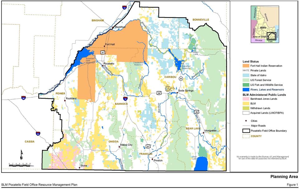
2 APPROVED RESOURCE MANAGEMENT PLAN INTRODUCTION This is the Approved Resource Management Plan (ARMP) for the public lands administered by the Bureau of Land Management (BLM) Pocatello Field Office (PFO). Purpose and Need This ARMP is needed because regulatory and resource conditions have changed, as have public demands, which warranted revisiting decisions in the 1981 Malad Management Framework Plan (MFP) and the 1988 Pocatello RMP, which were previously used to guide management of public lands within the PFO. Many new laws, regulations, policies, and resource/resource use issues have created a need for additional public land management considerations. As a result, some of the decisions in the 1981 Malad MFP and the 1988 Pocatello RMP are no longer valid or have been superseded by requirements that did not exist when they were prepared. Likewise, user demands and impacts have evolved, requiring new management direction. The purposes of this ARMP are to respond to resource conditions that have changed, to respond to new issues, and to provide a comprehensive framework to guide management of public lands and interests administered by the PFO, with a focus on maintaining or restoring resource conditions and helping provide community stability through resource use and enjoyment. Planning Area The PFO boundary defines the planning area (Figure 1), which encompasses 5,142,100 acres in the southeastern Idaho counties of Bannock, Bear Lake, Bingham, Bonneville, Caribou, Cassia, Franklin, Oneida, and Power. The BLM administers about 12 percent, or 613,800 acres, of public land in the planning area. Land ownership is mixed and includes lands administered by the federal government, the Fort Hall Indian Reservation, and the State of Idaho and owned by private entities. Over 34 percent of the planning area is administered by the BLM, the United States Forest Service (USFS), and the United States Fish and Wildlife Service (USFWS). This RMP applies only to public lands in the planning area and to the federal mineral estate administered by the PFO. Figure 1 is a detailed map of the planning area and land status. Planning Issues The BLM defines a planning issue as a matter of controversy, dispute, or general concern over resource management activities, the environment, or land uses. Planning issues are formulated based on public comments received during scoping, input from collaborative partners, and preliminary internal planning. After the formal scoping period ended in June 2003, the BLM identified the following primary planning issues, which are addressed in this RMP: How will the increasing off-highway vehicle (OHV) use and associated conflicts be managed within the planning area? April 2012 Record of Decision and Pocatello Field Office Approved Resource Management Plan ARMP - 1
 and the 1988 Pocatello RMP, which were previously used to guide management of public lands within the PFO.")
3 Pocatello Field Office Approved Resource Management Plan How does the BLM best manage the process of mining and reclamation to ensure containment and control of hazardous substances, such as selenium and other potential contaminants? How will the planning process address the need for acquiring and maintaining access to public lands, while protecting private property rights? How will the increase in recreational use and demand for quality recreation opportunities be balanced in the planning area? What effects will future management of sagebrush ecosystems have on greater sagegrouse and sagebrush-obligate species? How will social and economic benefits of commodity and amenity uses be balanced within the planning area? ISSUES CONSIDERED BUT NOT ANALYZED During scoping, several concerns were raised that were beyond the scope of this planning effort or represented questions on how the BLM would go about the planning process and implementation. There were several issues raised in scoping that are clearly of concern to the public but are governed by existing laws and regulations (for example, water quality). The Scoping Report for the Pocatello Resource Management Plan and Environmental Impact Statement (BLM 2003a) provides a comprehensive list of issues outside the scope of this RMP. The major issues considered but not analyzed further are summarized below and were not analyzed further in the Final Environmental Impact Statement (FEIS), for the reasons stated. Eliminate all livestock grazing. The BLM is mandated to provide for multiple uses, including livestock grazing, in accordance with the principles of multiple use and sustained yield embodied in the Federal Land Policy and Management Act (FLPMA) of 1976 and the Taylor Grazing Act of The Idaho Standards for Rangeland Health and Guidelines for Livestock Grazing Management (BLM 1997) provides guidance to the BLM for evaluating the conditions of allotments. The BLM can adjust grazing activities to respond to land conditions. Plan and zone private lands. The BLM does not have any authority to determine how private lands are used. Planning and zoning is done on a local level by county or municipal governments. Control populations of beaver, raccoons, and predators, stock fish, and other wildlife management. The BLM manages habitat rather than populations and does not have the authority to determine what species will be or should be controlled or reintroduced. The RMP may identify areas or parameters to be considered when other agencies propose wildlife management activities. Implementation of Grasslands Reserve Program initiatives. The BLM does not administer the Grasslands Reserve Program, which is administered by the US Department of Agriculture, Natural Resources Conservation Service. April 2012 Record of Decision and Pocatello Field Office Approved Resource Management Plan ARMP - 2

4
5 Pocatello Field Office Approved Resource Management Plan Conduct special research. Various commenters requested that the BLM conduct specialized research, such as the effects of pesticides and herbicides on aquatic species and the effects of power lines, energy corridors, and wind energy sites on wildlife populations. The BLM periodically conducts specific research related to implementation activities on a project basis but is not a research agency. Instead, it contributes funding to other agencies or institutions to conduct research, which is implemented on a case-by-case basis. Provide a designated transportation network. The ARMP provides direction in terms of what areas will be closed, restricted/limited to designated trails or roads, or open. The BLM will prepare travel management plan(s) that provide for specific routes and designations, upon approval of this RMP. Control the flow of water through the Oneida Narrows. The BLM does not have the authority to manage the release of water through the Oneida Narrows. Management direction in this RMP recognizes the use of the water and flow variability. Designate roadless areas as Wilderness Study Areas (WSAs). In the Proposed RMP, the BLM did not propose any additional WSAs over the existing 11,200 acres. Thirteen existing Areas of 4 Critical Environmental Concern (ACEC) (six ACECs and seven Research Natural Areas [RNA]) are redesignated in this RMP, with the Petticoat Peak RNA being newly designated. LEGISLATIVE CONSTRAINTS The FLPMA is the primary authority for the BLM s management of public lands. This law provides the overarching policy by which public lands are managed and establishes provisions for land use planning, land acquisition and disposition, administration, range management, rights-of-way (ROW) designation, management area designation, and the repeal of certain laws and statutes. NEPA provides the basic national charter for environmental responsibility and requires the consideration and public availability of information on the environmental impacts of major federal actions significantly affecting the quality of the human environment. In concert, these two laws provide the guidance for all activities on the public lands administered by the BLM. PLANNING CRITERIA Preliminary planning criteria were developed before the public scoping meetings to set the focus for this planning effort and to guide decision making by topic. They are the standards, rules, and guidelines for collecting data, formulating alternatives, and selecting alternatives in the RMP development process. These preliminary criteria were introduced to the public for review in the Pocatello Resource Management Plan Revision Public Scoping Briefing Package, released in April 2003 (BLM 2003a). This was also posted on the project website and was made available at the scoping meetings in May and June The public scoping briefing package identified 4 During the RMP planning process, seven ACECs and seven RNAs were revisited and reviewed for appropriateness of the designation and management. However, during summer 2006, a wildland fire destroyed historic structures associated with the Van Komen Homestead ACEC. Thus, of the 14 original ACECs and RNAs, 13 will be redesignated. In the Proposed RMP, management direction has been updated, in which the Van Komen Homestead ACEC designation has been removed, with the area no longer managed as an ACEC. Delisting the Van Komen Homestead ACEC designation is part of this Approved RMP. April 2012 Record of Decision and Pocatello Field Office Approved Resource Management Plan ARMP - 5

6 Pocatello Field Office Approved Resource Management Plan nineteen preliminary issues, including subsequent relevant planning criteria that guided analysis for each planning issue. Comments on the preliminary planning criteria were collected through June 30, 2003, and were incorporated and carried forward as appropriate to use in forming judgments about decision making, analysis, and data collection during the planning process (Table 5). Table 5. Planning Criteria Summary Resource or Resource Use General Air quality Water quality Soils Riparian vegetation Upland vegetation Planning Criteria All lands within the planning area will be managed in compliance with applicable local, state, tribal, and federal air quality laws, statutes, regulations, standards, and implementation plans. This includes applicable conformity regulations for BLM-initiated or -authorized activities within designated nonattainment or maintenance areas. Recognize Idaho Non-Point Source Management Program Plans and relevant state water quality standards. Recognize Idaho Department of Environmental Quality (IDEQ) total maximum daily load program and other water quality programs. Incorporate appropriate management practices where applicable. The principles of multiple use and sustained yield, as set forth in FLPMA, will be applied in the RMP. The RMP will comply with applicable federal and state laws and regulations. The RMP will be accompanied by an environmental impact statement (EIS) that will comply with NEPA. Incorporate program and activity best management practices (BMPs), as appropriate. Incorporate Idaho Standards for Rangeland Health and Guidelines for Livestock Grazing Management (BLM 1997). Incorporate guidance from scientific findings of the Interior Columbia Basin Ecosystem Management Project (ICBEMP). Comply with Executive Orders (floodplains) and (wetlands). Maintain, improve, or restore natural functions to benefit water storage, groundwater recharge, water quality, and fish and wildlife values. Design BMPs to maintain or improve resource integrity. Incorporate Idaho Standards for Rangeland Health and Guidelines for Livestock Grazing Management (BLM 1997). Apply BLM Idaho Riparian Policy guidance, as applicable. Incorporate Idaho Statewide Comprehensive Outdoor Recreation and Tourism Plan. Incorporate Visual Resource Management classifications. Incorporate Idaho Standards for Rangeland Health and Guidelines for Livestock Grazing Management (BLM 1997). Provide for the protection and restoration of native species. Provide for multiple use and sustained yield of forage for wildlife and domestic livestock. In consultation with the Idaho Department of Fish and Game (IDFG), ensure that wildlife habitat is sustained. April 2012 Record of Decision and Pocatello Field Office Approved Resource Management Plan ARMP - 6

7 Pocatello Field Office Approved Resource Management Plan Table 5. Planning Criteria Summary Resource or Resource Use Invasive species/ noxious weeds Cultural resources Visual resource management Special status species Fish and wildlife Fire management Planning Criteria Incorporate guidance described in BLM Manual Section 8400 Visual Resource Management. Integrate weed management guidelines and design features identified in the Vegetation Treatment on BLM Land in the 13 Western States EIS and the Northwest Area Noxious Weed Control Program EIS (BLM 2007). Protect nontarget and special status plant species during treatments. Incorporate Idaho Standards for Rangeland Health and Guidelines for Livestock Grazing Management (BLM 1997). Consider availability of alternatives to mix or combine control methods to increase effectiveness of application techniques. Adhere to laws and executive orders requiring control of invasive species/noxious weeds on federal land. Comply with Executive Order 13112, Invasive Species (February 1999). Consultation with tribal governments and the Idaho State Historic Preservation Office (SHPO) to assist in evaluating planned cultural resources uses. Identify and protect historical and cultural places. Protect, preserve, and enhance sites listed on the National Register of Historic Places (NRHP). Through consultation with tribal governments, ensure that management measures are implemented in a manner that protects and provides access to sacred places, in accordance with the American Indian Religious Freedom Act and Executive Order Incorporate as applicable Interior Columbia Basin Science Assessment guidance. Incorporate applicable conservation agreement and strategy plans (e.g., Bonneville cutthroat trout and greater sage-grouse). Incorporate management actions that do not jeopardize the continued existence of federally listed threatened or endangered plant or animal species or that result in the destruction or modification of critical habitat. Incorporate Idaho Standards for Rangeland Health and Guidelines for Livestock Grazing Management (BLM 1997). Incorporate management actions that protect sensitive species and do not contribute to the listing of species proposed for federal listing (candidate species). Incorporate as applicable the Interior Columbia Basin Science Assessment guidance. Protect and preserve genetic integrity. Consider risks associated with federal listing of fish species. Protect and maintain the intrinsic and recreational values associated with native and appropriate nonnative species. Identify habitat needs in consultation with the IDFG. Protect critical deer and elk winter range and big game habitat. Incorporate National Fire Plan direction. Ensure public health and safety in the wildland urban interface. Ensure the safety of the public and firefighters, while protecting natural resources, historic properties, and private property. Coordinate with those developing community assistance plans. April 2012 Record of Decision and Pocatello Field Office Approved Resource Management Plan ARMP - 7

8 Pocatello Field Office Approved Resource Management Plan Table 5. Planning Criteria Summary Resource or Resource Use Forestry Livestock grazing Recreation opportunities OHV management Planning Criteria Implement guidance and criteria contained in the PFO Programmatic Forestry Environmental Assessment, December Recognize the ICBEMP: Scientific Assessment, September 1999, and guidance contained in BLM Manual 5400/ a1. Incorporate Idaho Standards for Rangeland Health and Guidelines for Livestock Grazing Management (BLM 1997). Enhance and protect wildlife habitats. Consider pre-european settlement stand composition. Address availability of access. Recognize public demand for forest products. Incorporate continuing effects of drought, insects, and disease. Inventory Timber Production and Capability Classifications. Conform with existing laws, regulations, and BLM policy pertaining to livestock grazing on public lands. Incorporate Idaho Standards for Rangeland Health and Guidelines for Livestock Grazing Management (BLM 1997). Consider ecological site inventory information. Protect important biological resource functions that provide for soil stability, water quality, and healthy riparian and upland vegetation communities and maintain conditions for desired plant communities. Authorize use to minimize environmental impacts under the principles of multiple use and sustained yield. Consider availability of law enforcement. Consider need to provide for and enhance recreation opportunities to accommodate use and reduce impacts on resources. Consider lands identified as Special Recreation Management Areas (SRMA) and those areas subject to special measures to protect resources or reduce conflicts among uses. Ensure that recreation facilities can be properly maintained before proposals and construction of new facilities. Consider need to provide and enhance recreation opportunities to accommodate use and reduce impacts on resources. Manage for public safety. Consider need to minimize damage to soil, watershed, vegetation, and other resources. Consider need to minimize harassment of wildlife or significant disruption of wildlife habitats. Consider need to minimize conflicts between OHV use and other existing or proposed recreation uses. Ensure compatibility of OHV designations with designations and conditions on neighboring federal, state, county, and municipal subdivisions, taking into account safety, noise, and related factors. Comply with the BLM s National OHV Management Strategy. Comply with Executive Orders and April 2012 Record of Decision and Pocatello Field Office Approved Resource Management Plan ARMP - 8
. Enhance and protect wildlife habitats. Consider pre-european settlement stand composition.")
9 Pocatello Field Office Approved Resource Management Plan Table 5. Planning Criteria Summary Resource or Resource Use Rights-of-way Access Land tenure adjustments Minerals and energy management and development Special designations American Indian concerns Treaty rights Social and economic sustainability Planning Criteria Consider the need to make public lands available for the orderly and efficient development of energy and mineral resources. Identify areas that are managed specifically to protect nonmineral resource values but may conflict with mineral resource development. Recognize Fort Bridger Treaty rights with all associated management activities and uses. Accommodate the West Wide Corridor Study Amendment and Programmatic EIS (BLM 2009). Apply the appropriate policies and BMPs identified in the Record of Decision (ROD) for the Wind Energy Development Programmatic EIS and Associated Land Use Plan Amendments (BLM 2005b). Comply with Section 503 of FLPMA. Recognize the need to minimize adverse environmental impacts and the proliferation of separate ROWs. Use existing common ROWs to the extent possible. Identify public lands with ROW corridors that may or may not be suitable for additional ROWs. Identify areas where corridors are not permitted. Identify conflicts with existing or potential resource values and uses. Consider Visual Resource Management classifications. Consider the type and need of access. Consider conflicts with existing or potential resource values and uses. Comply with Section 205 of FLPMA. Consider cost and benefits. Comply with the Federal Land Transaction Facilitation Act of 2000 and FLPMA. Facilitate access to public lands and resources. Maintain or enhance important resource values uses. Consider maintaining or enhancing local social and economic values. Improve management efficiency by eliminating isolated tracts and consolidating public lands. Comply with FLPMA, Sections 201 and 202. Comply with Interim Management Policy for Lands Under Wilderness Review, BLM Handbook Analyze rivers and streams for potential addition to the National Wild and Scenic Rivers System (NWSRS), in accordance with BLM Manual 8351, Wild and Scenic Rivers Policy. Manage to retain values that make cultural resources and areas significant to tribal members. Protect cultural use areas, in cooperation with tribal governments. Comply with the Native American Graves Protection and Repatriation Act of 1990 and Amendments (post 1987) to the National Historic Preservation Act (NHPA). Recognize the need to promote social and economic diversification and resiliency in southeastern Idaho. Recognize increasing demand for outdoor recreation opportunities. Recognize that local community economies depend on goods and services from public lands. April 2012 Record of Decision and Pocatello Field Office Approved Resource Management Plan ARMP - 9

10 Pocatello Field Office Approved Resource Management Plan RELATIONSHIP TO BLM POLICIES, PLANS, AND PROGRAMS This RMP supersedes all previous land use planning decisions pertaining to the public lands in the planning area administered by the PFO. This RMP also complies with all current BLM policies, regulations, and program guidance. In July and August 2008, an interdisciplinary team reviewed public lands in the Pocatello planning area for wilderness characteristics. This included the two WSAs (Petticoat Peak and Worm Creek), public lands previously inventoried in that were not included as WSAs, lands acquired since the initial inventories, roadless areas meeting the minimum 5,000- acre size criteria required by the Wilderness Act (16 USC, Section 1131[c][3]), and BLM administered public lands adjacent to other agency wilderness, WSAs, or recommended wilderness. In all, six areas were reviewed for wilderness characteristics. This review was based on field reports from the original inventory, published reports and EISs, starting with the Idaho Intensive Wilderness Inventory Report (BLM 1980) and ending with the Idaho Wilderness Inventory Report (1991) to Congress, and the extensive knowledge of current resource staff members who have completed field work throughout the planning area. Based on this review, the team determined that none of the public lands reviewed exhibited wilderness characteristics because these public lands have been influenced by the presence of man s work (in contrast to the requirement set forth in 16 USC, Section 1131[c][1]), resulting in impacts on naturalness and poor opportunities for either solitude or a primitive and unconfined type of recreation. Specific lands reviewed were those previously eliminated from WSA consideration in the original inventory, newly acquired lands, roadless areas meeting the minimum size requirement, or BLM-administered public lands adjacent to USFS recommended wilderness. This review resulted in the PFO updating its wilderness inventory consistent with the FLPMA, Section 201, resulting in no additional public lands being identified that contain wilderness characteristics. Related Plans BLM planning regulations require its plans to be consistent with officially approved or adopted resource-related plans of other federal, state, local, and tribal governments, to the extent those plans are consistent with federal laws and regulations applicable to public lands. Plans formulated by federal, state, local, and tribal governments that relate to management of lands and resources were reviewed and considered as the Proposed RMP/Final EIS was developed. These plans are the following: Caribou National Forest Revised Forest Plan and EIS (USFS 2003); Greater Yellowstone Bald Eagle Management Plan 1995 update (Wyoming Game and Fish Department 1996); ICBEMP: Project Data (USFS and BLM 2001); Interior Columbia Basin Final EIS (USFS and BLM 2000); April 2012 Record of Decision and Pocatello Field Office Approved Resource Management Plan ARMP - 10
, public lands previously inventoried in 1978-1979 that were not included as WSAs, lands acquired since the initial inventories, roadless")
11 Pocatello Field Office Approved Resource Management Plan Conservation Plan for the Greater Sage-Grouse in Idaho (IDFG 2006); Guidelines for Management of Columbian Sharp-Tailed Grouse Habitats (Geisen and Connelly 1993); Inland Native Fish Strategy Environmental Assessment Decision Notice and Finding of No Significant Impact (BLM 1995); Memorandum of Agreement for Conservation and Management of Yellowstone Cutthroat Trout among Montana, Idaho, Wyoming, Nevada, Utah, USFS, Yellowstone National Park and Grand Teton National Park and the IDFG (Montana Department of Fish, Wildlife, and Parks et al. 2000); Utah Division of Wildlife Resources Range-Wide Conservation Agreement and Strategy for Bonneville Cutthroat Trout (Utah Division of Wildlife Resources 2000); Management Plan for Yellowstone Cutthroat Trout in Idaho (IDFG 2003); Memorandum of Understanding Concerning the Conservation of Spring Snails in the Great Basin (BLM et al. 1998); Portneuf Valley Particulate Matter (PM 10 ) Air Quality Improvement Plan (IDEQ 1999); Draft Portneuf Valley PM 10 Nonattainment Area State Implementation Plan, Maintenance Plan, and Redesignation Request (IDEQ 2004a); BMPs for Mining in Idaho (Idaho Department of Lands [IDL] 1992); Draft Selenium BMP Catalog for Phosphate Mining (Idaho Mining Association and IDEQ 2004); IDEQ s Final Area Wide Risk Management Plan (IDEQ 2004b); A View to the Future: A Comprehensive Historic Preservation Plan for Idaho (SHPO 2002); Proposed Plan Amendments and EIS for Small Wilderness Study Areas, Statewide (BLM 1988b); Idaho s Statewide Comprehensive Outdoor Recreation and Tourism Plan (Idaho State Parks and Recreation 2003); Comprehensive Management and Use Plan/EIS for the California National Historic Trail, Pony Express National Historic Trail, Oregon National Historic Trail, and Mormon Pioneers National Historic Trail (National Park Service 1998); Shoshone-Bannock Tribes Fire Management Plan; Shoshone-Bannock Tribes Forest Management Plan; Shoshone-Bannock Tribes Water Master Plan; and Upper Snake River Subbasin Plan in Columbia River Basin Fish and Wildlife Program (Northwest Power Planning Council 2004). April 2012 Record of Decision and Pocatello Field Office Approved Resource Management Plan ARMP - 11

12 Pocatello Field Office Approved Resource Management Plan MANAGEMENT DECISIONS Management decisions in this ARMP consist of three main components: Goals Broad statements of desired outcomes that are usually not quantifiable; Objectives Specific desired outcomes that are usually, but not always, quantifiable and measurable and may have established timeframes for achievement (objectives are identified as means to achieve goals); and Management Actions Anticipated actions to achieve desired outcomes, including actions to maintain, restore, or improve land health. Management decisions are organized by natural, biological, and cultural resources, resource uses and special designations. These management decisions apply to the public lands administered by the PFO throughout the life of the ARMP or unless the ARMP is amended or revised. Although the following decisions use the words restoration and rehabilitation interchangeably, management actions can promote or facilitate natural processes, while areas and functions are restored through the work of natural processes. Decisions regarding wildlife resources also use the words habitat and species synonymously. The BLM is delegated with management authority over habitats and other agencies (e.g., IDFG) are charged with managing species and populations; therefore, in discussions on actions to species, the text should be read as actions on habitats that affect species. Additionally, management of resources and resource uses have socioeconomic and environmental justice effects, but no management actions are specifically designed for socioeconomics or environmental justice. Socioeconomic and environmental justice effects from implementing management actions for other resources and resource uses can be found in the Proposed RMP/FEIS (BLM 2010). Management decisions made in this ARMP for resources, resource uses, and special designations are as follows: Resources (Natural, Biological, and Cultural) General (GE), Air Quality (AQ), Cultural Resources (CR), Tribal Treaty Rights and Interests (TR), Soil and Water (SW), Paleontological Resources (PR), Vegetation (VE), Fish and Wildlife (FW), Special Status Species (SS), Visual Resources (VR), and April 2012 Record of Decision and Pocatello Field Office Approved Resource Management Plan ARMP - 12

13 Pocatello Field Office Approved Resource Management Plan Wildland Fire Management (WF). Resource Uses Forestry (FO), Lands and Realty (LR), Livestock Grazing (LG), Minerals and Energy (ME), Recreation (RE), and 5 Comprehensive Trails and Travel Management (TM). Special Designations Administrative Designations (AD). PLAN IMPLEMENTATION AND PUBLIC INVOLVEMENT To achieve the goals and objectives set forth in this ARMP, the PFO will develop an implementation strategy that provides for the systematic accomplishment of the management decisions. During implementation, additional analysis and documentation will be required to comply with NEPA. Decisions to implement site-specific projects will be subject to administrative review when such decisions are made. This strategy ties management decisions in the ARMP to specific proposed projects on the ground and identifies budget and work load planning requirements. Implementing all proposed actions and decisions identified is contingent on staffing, priorities, and funding. During planning and analysis of specific projects to implement management decisions, the BLM, the public, tribes, and other federal or state agencies will be provided with opportunities to be involved. The BLM may also develop implementation-level plans (e.g., activity plans) to provide more specific guidance for managing certain areas, resources, or resource uses. Opportunities will be afforded as appropriate to the public, tribes, and other federal or state agencies in these implementation-level planning efforts. 5 Goal RE-4 and the subsequent objectives and actions that were previously listed in the Recreation (RE) section are now identified as Goal TM-1 in the section Comprehensive Trails and Travel Management (TM). Neither the wording nor content of the goal, objectives, and management actions have been changed from the Proposed RMP/ FEIS. This is an editorial change and is consistent with Appendix C, Land Use Planning Handbook (H1601-1) (BLM 2005a). April 2012 Record of Decision and Pocatello Field Office Approved Resource Management Plan ARMP - 13

14 Pocatello Field Office Approved Resource Management Plan General GENERAL (GE) NATURAL, BIOLOGICAL, AND CULTURAL RESOURCES Goal GE-1. Continuously update resource and use information/data in order to proactively address changing needs and or conditions. Objective GE-1.1. Inventories and surveys documenting the condition and extent of resources/uses are given sufficient emphasis to monitor changes in conditions, provide measurements of ecosystem health or baseline data/information, and enable specialists to respond to changes when needed. Action GE Resource inventory, survey and monitoring programs will be implemented as appropriate. Action GE Information gained through inventory, survey and monitoring programs will be used in making management decisions. Action GE Undertake proactive management of public land activities, including, but not limited to, mitigating potential adverse effects. Goal GE-2. Consistent with multiple use management and sustained yield, achieve desired resource and use conditions while providing for an ecologically healthy environment. Objective GE-2.1. Reduce impacts from management actions, and maintain or improve resource conditions. Action GE As appropriate, management guidelines, techniques and practices (Appendix A) will be applied to proactively make progress towards desired resource and/or use conditions. Action GE As appropriate, the modification of existing or development of new guidelines, techniques and practices to reduce adverse effects or maintain/improve resource conditions will be analyzed through the NEPA process. Goal GE-3. Provide for proper nutrient cycling, hydrological cycling and energy flow consistent with multiple use management and sustained productivity. Objective GE-3.1. Restore or improve the public lands adversely affected by major surface disturbance resulting from activities such as but not limited to mineral and energy development, wildland fire, and ROW development. Action GE Applicable Idaho Standards for Rangeland Health and indicators (BLM 1997) will be employed to determine the successfulness of reclamation, rehabilitation or restoration activities following major surface disturbance. April 2012 Record of Decision and Pocatello Field Office Approved Resource Management Plan ARMP - 14

15 Pocatello Field Office Approved Resource Management Plan Air Quality AIR QUALITY (AQ) Goal AQ-1. Comply with existing laws and regulations to meet health and safety requirements. Objective AQ-1.1. Control the particulate level impacts from permitted/authorized activities. Action AQ As appropriate, management techniques, practices or guidelines to control fugitive dust emissions will be implemented as identified in Appendix A. Action AQ Planned activities will be conducted in accordance with the US Environmental Protection Agency (EPA) approved Idaho State Implementation Plan of the Clean Air Act and the Idaho/Montana Smoke management program. Action AQ Fire treatment activities (e.g., wildland fire use [WFU], prescribed fire, and the appropriate management response [AMR]) will be consistent with the EPA, National Ambient Air Quality Standards for particulate matter (PM10 and PM2.5) and coordinated through the Montana/Idaho Airshed Group (MIAG) Smoke Management Program. April 2012 Record of Decision and Pocatello Field Office Approved Resource Management Plan ARMP - 15

16 Pocatello Field Office Approved Resource Management Plan Cultural Resources CULTURAL RESOURCES (CR) Goal CR-1. Provide for the identification, protection, and enhancement of historical and cultural sites to ensure scientific and socio-cultural values are maintained and are available for appropriate uses by present and future generations. Objective CR-1.1. Manage important known and future identified cultural and historical sites to maintain and preserve their educational, scientific and public benefit. Action CR Federally recognized tribes (e.g., Shoshone-Bannock Tribes) will be consulted with on the evaluation, impact assessment, development of mitigation measures, and management of cultural resources and traditional cultural properties. Action CR In compliance with Section 106 of the NHPA, the effects of all actions or undertakings (as defined in the NHPA) on cultural resources including traditional cultural properties will be considered through appropriate identification, evaluation, assessment of effects, and implementation of appropriate management measures (e.g., signing, fencing/gating, stabilization, detailed recording, archaeological data recovery techniques). This consideration will be conducted through consultation with the Idaho SHPO and Tribes. Action CR Archaeological collections from the PFO will be properly maintained in conformance with 36 Code of Federal Regulations 79 and Bureau policy and will be available for study by qualified researchers. Action CR Special management measures will be developed, enhanced and/or maintained for currently identified cultural resources: The Indian Rocks ACEC according to the Indian Rocks Cultural Resources Management Plan (August 1997), and The Juniper Town Site will be managed according to approved plans considering stabilization and rehabilitation of historic structures and interpretive signage. Action CR Manage identified cultural resource management areas in the following manner: approximately 2,100 acres (Historic Railroad Grade, Blackrock Canyon, and Historic Trail Segments) with a No Surface Occupancy (NSO) stipulation for fluid minerals, and approximately 6,300 acres as sensitive areas (Prehistoric Areas A-G, Upper Valley, and Bear Lake Plateau). Action CR Maps of known cultural resources, cultural resource inventories and areas of cultural resource sensitivity will be reviewed and updated accordingly. Action CR Review and update current holdings for cultural resource site and survey records with Idaho SHPO and acquire any new or missing documents. Action CR Known or anticipated cultural resources will be allocated to the following uses according to their nature and relative preservation value. Scientific Use o Preserved until research potential is realized Conservation for Future Use o Preserved until conditions for use are met April 2012 Record of Decision and Pocatello Field Office Approved Resource Management Plan ARMP - 16

17 Pocatello Field Office Approved Resource Management Plan Cultural Resources Traditional Use o Long-term preservation Public Use o Long-term preservation, on-site interpretation Experimental Use o Protected until used Discharged from Management o No use after recordation; not preserved Action CR Known or anticipated cultural uses will be subject to the following use actions. Scientific Use: Permit appropriate research, including data recovery Conservation for Future Use: Propose protective measures/designations Traditional Use: Consult with tribes; determine limitations Public Use: Determine limitations, permitted uses Experimental Use: Determine nature of experiment Discharged from Management: Remove protective measures Action CR Formal nominations for historic and traditional cultural properties that are eligible for the listing on the NRHP will be prepared as necessary. Action CR As the need is identified, cultural resource management plans (CRMP) to provide more specific management direction for cultural resources, including NRHP-listed and eligible properties, classes of cultural resources or defined areas, Traditional Cultural Properties and historic trails (e.g., Blackfoot River, Oregon/California Trail and alternate routes) will be developed. Action CR As appropriate, ethnographic, prehistoric and historic overviews will be prepared and maintained to guide future cultural resource compliance studies, research and resource allocations. Objective CR-1.2. Reduce imminent threats from natural or human-caused deterioration, or potential conflict with other resource uses. Action CR Proposed activities will only be authorized after compliance with Section 106 of NHPA has been completed and documented, including, where applicable, consultation with the SHPO and federally recognized Indian tribes (e.g., Shoshone- Bannock Tribes). Any persons/entities authorized to conduct activities with the potential to alter, damage or destroy cultural resources of significant interest on public lands will be required to immediately bring to the attention of the Authorized Officer any discovery of cultural resources. Activities affecting the discovery will be suspended immediately with the discovery left intact until the Authorized Officer is able to evaluate the discovery and take appropriate action to protect or remove the resource. April 2012 Record of Decision and Pocatello Field Office Approved Resource Management Plan ARMP - 17

18 Pocatello Field Office Approved Resource Management Plan Cultural Resources Action CR Partnerships, agreements, contracts, and volunteer coordinated efforts will be encouraged to expand the inventory, protection and management of cultural resources in areas deemed to be of high probability but lacking in field survey data. Areas considered high priority for proactive cultural resource inventory include: Snake River/Massacre Rocks area, Portneuf River/Chesterfield area, Blackfoot River Watershed, Curlew Grassland/Badger Hole Spring Area, Bear River Corridor, Elkhorn Mountain/Malad Obsidian Source Action CR Information on existing and changing conditions at cultural resource sites will be focused on sites deemed to be at-risk to impacts. Cultural resource monitoring data will be collected systematically using standardized formats to allow for assessment and comparison of site conditions over time. Approximately cultural resource sites will be monitored annually. Action CR Information on documented cultural resources and cultural resource investigations (e.g., cultural resource inventories) will continue to be maintained and updated with current information so that cultural resources are adequately considered in future planning and management actions. Action CR Cultural resource information will be made available to qualified researchers for study and use. April 2012 Record of Decision and Pocatello Field Office Approved Resource Management Plan ARMP - 18

19 Pocatello Field Office Approved Resource Management Plan Tribal Treaty Rights and Interests TRIBAL TREATY RIGHTS AND INTERESTS (TR) Goal TR-1. Provide for Tribal Treaty Rights and Interests on unoccupied public lands and public lands with the ceded reservation boundary. Objective TR-1.1. Maintain traditional/cultural use values and the health of land and water resources so treaty rights and interests can be fulfilled by tribal members on unoccupied public lands and those public lands within the ceded reservation boundary. Action TR Land management decisions affecting BLM-administered public lands will be made in consideration of the 1868 Fort Bridger Treaty which reserves to Tribal members off-reservation treaty rights (i.e., gathering, hunting, fishing and practicing tribal cultural activities) on unoccupied public lands and on previously ceded reservation lands the right to graze livestock. Action TR Tribal governments will be consulted on land management actions and allocations that could affect treaty rights. April 2012 Record of Decision and Pocatello Field Office Approved Resource Management Plan ARMP - 19

20 Pocatello Field Office Approved Resource Management Plan Soil and Water SOIL AND WATER (SW) Goal SW-1. Provide for soil quality, productivity and hydrological function within naturally sustainable limits. Objective SW-1.1. Incorporate resource protections to minimize soil loss when the long-term health of soil function and productivity is at risk. Action SW Appropriate management techniques, guidelines or practices (Appendix A) will be implemented to limit soil loss to an amount, generally 5 tons per acre per year (5 ton/acre/yr) (Schertz 2006) that will not affect its long-term quality, productivity or hydrological function. Action SW Reclamation of disturbed sites will be done as soon as conditions (e.g., soil moisture, weather) will support or promote success. Action SW Surface-disturbing activities (e.g., Oil and Gas/Geothermal leasing stipulations) on erosive soils will be stipulated/mitigated as appropriate. Goal SW-2. Protect and maintain watersheds so that they appropriately capture, retain and release water of quality that meets state and national standards and do not impair source water protection areas. Objective SW-2.1. Manage public land activities to maintain or contribute to the long-term improvement of surface and ground water quality Action SW Appropriate management techniques, guidelines or practices (Appendix A) will be applied to promote: The delisting of water quality impaired water bodies as identified by the State of Idaho. The protection of groundwater, Designated beneficial uses (e.g., cold water biota). Action SW Cooperate with adjacent landowners, state agencies, Tribes, communities, municipalities, other agencies, other individuals and organizations to meet beneficial use criteria. Action SW Priority areas for stream management and restoration will be based upon the following: 1. Presence of sensitive species, 2. Amount of the stream reach on BLM-administered public lands or under the BLM control, and 3. Condition and importance of the stream for achieving multiple use objectives. Action SW Stream crossings, if necessary, will be designed to minimize adverse impacts on soils, water quality, and riparian vegetation and provide for fish passage as appropriate. Action SW As appropriate, roads and trails adjacent to streams or riparian areas that impact water quality may be redesigned, repaired, maintained, or re-located to a location not impacting the water quality. April 2012 Record of Decision and Pocatello Field Office Approved Resource Management Plan ARMP - 20
 will be implemented to limit soil loss to an amount, generally 5 tons per acre per year (5 ton/acre/yr) (Schertz 2006) that will not affect its long-term quality, productivity")
21 Pocatello Field Office Approved Resource Management Plan Paleontological Resources PALEONTOLOGICAL RESOURCES (PR) Goal PR-1. Provide for the identification, protection, and management of paleontological resources for the preservation, interpretation and scientific uses by present and future generations. Objective PR-1.1. Maintain and protect paleontological resources for their educational and scientific benefits. Action PR Areas will be identified that may contain significant paleontological resources. Action PR Areas will be identified that may have potential conflicts with authorized activities and resources/uses. Action PR Significant paleontological resources (generally rare or vertebrate fossils, as determined by current BLM policy) will be protected from disturbance, or the effects of disturbance mitigated to conserve scientific, interpretive, and legacy values. Action PR In areas where the potential for paleontological values exist (e.g., alluvial valleys) inventories will be conducted (e.g., literature search, field surveys) prior to authorizing activities or as appropriate, protective measures/protocols will be developed to be followed should paleontological resources be found. Action PR Any persons/entities authorized to conduct activities with the potential to alter, damage or destroy paleontological resources of significant interest on the public lands will be required to immediately bring to the attention of the Authorized Officer any discovery of paleontological resources. Activities affecting the discovery will be suspended immediately with the discovery left intact until the Authorized Officer is able to evaluate the discovery and take appropriate action to protect or remove the resource. Action PR Permits will be required for commercial and non-commercial removal of paleontological resources from public lands. However, permits will not be required for non-commercial removal of small amounts of common or non-significant fossils (generally plants and common invertebrates) for personal hobby and enjoyment uses. April 2012 Record of Decision and Pocatello Field Office Approved Resource Management Plan ARMP - 21
22 Pocatello Field Office Approved Resource Management Plan Vegetation VEGETATION (VE) Goal VE-1. Provide for the proper functioning condition (PFC) of riparian areas. Objective VE-1.1. Maintain properly functioning riparian areas and restore/improve those areas that are not at PFC. Action VE Appropriate management guidelines, techniques or practices (Appendix A) will be implemented to control erosion, stabilize streambanks, shade/reduce water temperature, and encourage a diversity of desirable riparian vegetation. Action VE Idaho Standards for Rangeland Health (BLM 1997) will be implemented to maintain or improve riparian areas. Action VE Mitigation measures will be identified to reduce visual contrasts with rehabilitation/restoration actions identified to address landscape modifications on a caseby-case basis. Action VE Stream crossings, if necessary, will be designed to minimize adverse impacts on soils, water quality and riparian vegetation. Goal VE-2. Prevent the establishment of invasive species/noxious weed species. Objective VE-2.1. Treat invasive species/noxious weeds to decrease or control the total number of acres occupied. Action VE Invasive species/noxious weeds will be treated based upon the following priority: 1. Idaho Noxious Weeds list 2. Invasive species/noxious weeds Action VE Priority treatment areas will be: RNAs Riparian areas Springs/Seeps Developed Recreation Sites/Campgrounds/Campsites Heavily used roads/trails Big game winter range Special Status Species (flora habitat area) Wildland Urban Interfaces (WUIs) Mine reclamation sites New areas identified: treat smallest populations first Action VE When authorizing new permitted/authorized activities, stipulations will be incorporated for the prevention and treatment of invasive species/noxious weeds as applicable. Examples of such stipulations to consider will promote: April 2012 Record of Decision and Pocatello Field Office Approved Resource Management Plan ARMP - 22
23 Pocatello Field Office Approved Resource Management Plan Vegetation The replacement of invasive species/noxious weeds by perennial plant cover which includes purchasing and planting of desirable seeds or plants. The use of perennial green fire breaks when emergency stabilization and rehabilitation (ES&R) or restoration efforts are planned/implemented. Invasive species/noxious weed management being integrated into any new or renewal of permitted/authorized activities resulting in major surface disturbance. Action VE As appropriate, chemical, biological, mechanical and manual methods will be used in treating invasive species/noxious weeds. The use of biological control agents will be promoted when reasonable as identified through current BLM policy. Action VE Herbicide use will be consistent with current BLM policy (e.g., Record of Decision. Vegetation Treatments Using Herbicides on Bureau of Land Management Lands in 17 Western States. Programmatic Environmental Impact Statement. US Department of the Interior, Bureau of Land Management. September 2007.) Action VE Projects involving the application of herbicides, pesticides and insecticides that may affect Special Status Species will be analyzed at the project level and designed such that applications will support species conservation and recovery and minimize risks of exposure. Action VE Control of invasive species/noxious weeds will be coordinated with adjacent land owners and local governments through cooperative management programs. Action VE Fuels and restoration projects will be coordinated with other programs to reduce the risk of invasive species/noxious weeds. Action VE Suppression equipment will be washed for invasive species/noxious weeds at designated sites. Action VE Following wildland fire and prescribed fire treatments, chemical, mechanical, and revegetation/restoration treatments will utilize appropriate plant materials to provide the best opportunity to stabilize sites and prevent dominance of invasive species/noxious weeds. The use of native plant materials will be emphasized in ES&R and restoration activities. Action VE Where hay or straw will be used on public lands for permitted/authorized and internal BLM activities, state-certified noxious weed free hay/straw will be required. Action VE Integrated weed management strategies will be coordinated and developed with Tribal, Federal and State agencies and local governments at appropriate scales to restore affected BLM-administered public lands. Such strategies or actions may include but are not limited to: coordination of treatment efforts; identification of priority areas; promote public awareness; and develop educational material regarding control, prevention, etc. April 2012 Record of Decision and Pocatello Field Office Approved Resource Management Plan ARMP - 23
24 Pocatello Field Office Approved Resource Management Plan Vegetation Goal VE-3. Provide for old growth characteristics where forest treatments are implemented. Objective VE-3.1. Maintain or contribute towards the restoration of old growth structure and composition in areas where forest treatments, including those authorized under the Healthy Forests Restoration Act projects, are proposed. Action VE Structure and composition characteristics for old growth forest/woodland types will be used as defined in current literature and or Characteristics of Old-Growth Forests in the Intermountain Region, USFS Intermountain Region, Ogden Utah (Hamilton 1993) as amended or revised. Goal VE-4. Manage vegetation types to provide for their continued presence as part of an ecologically healthy system. Objective VE-4.1. In Low- and Mid-Elevation Shrub and Mountain Shrub types, commensurate with site potential, maintain or increase Land Health Condition (LHC)-A acres as described below so the landscape is composed of a diversity of desirable/native herbaceous and shrub/woody species consisting of at least 15-25% sagebrush canopy cover in greater sage-grouse habitat in the Low- and Mid-Elevation Shrub types and at least 25% shrub cover in the Mountain Shrub type. Desired LHC Description LHC-A - All key components are present as identified in land health standards and as described in the definition of Fire Regime Condition Class (FRCC) 1. LHC-B - Some or all of the key components as identified in land health standards are present and as described in the definition of FRCC 2. LHC-C - Key components are absent as identified in land health standards and as described in the definition of FRCC 3. Percent LHC Desired > 60% 20-25% < 20% Action VE Activities will be permitted/authorized in a manner consistent with Idaho Standards for Rangeland Health (BLM 1997). Action VE Priority areas for treatment and restoration will be: 1. Greater sage- and Columbian sharp-tailed grouse Source and Key habitat: a. Enhance source habitat, b. Treat areas of low resilience c. Treat areas that pose a fire risk to source habitats, d. Enhance key habitat areas, e. Treat areas that pose a fire risk to key habitats, f. Enhance restoration habitat 2. Habitats for the conservation and recovery of special status species. 3. Areas with hazardous fuels or potential for catastrophic wildland fire. 4. Areas infested by invasive species/noxious weeds. April 2012 Record of Decision and Pocatello Field Office Approved Resource Management Plan ARMP - 24
25 Pocatello Field Office Approved Resource Management Plan Vegetation 5. Areas at risk of loss of key ecosystem components/functions (structure, diversity, composition, hydrological function, nutrient cycling, energy flow). 6. Areas adversely impacted/degraded by uses or activities (e.g., recreation, OHV, grazing, mining) 7. Crested wheatgrass seedings. Criteria to treat and maintain the crested wheatgrass forage base are as follows: The AMR is full suppression with perimeter control until canopy cover exceeds 25 percent. When canopy cover exceeds 25 percent, the AMR considered will range from full suppression to monitoring. Consider various treatment methods (e.g., mechanical, chemical, and prescribed fire) as areas exceed 25% sagebrush canopy cover. As areas are treated allow for no less than 15% sagebrush canopy cover. Interseed desirable species that add diversity while not displacing crested wheatgrass. Treat areas to prevent the establishment or spread of invasive species/noxious weeds. 8. Juniper encroached areas. Objective VE-4.2. In the Aspen/Aspen Conifer Mix and Dry Conifer types, commensurate with site potential, maintain or increase LHC-A and B acres as described below so the landscape is composed of 40% mixed Aspen/Dry Conifer and 60% Aspen dominate areas consisting of 500-1,000 stems/acre w/5-15 ft. height resulting in the distribution of age classes of <30 years (40%), years (40%), and >80 years (20%). Desired LHC Description LHC-A - All key components are present as identified in land health standards and as described in the definition of FRCC 1. LHC-B - Some or all of the key components as identified in land health standards are present and as described in the definition of FRCC 2. LHC-C - Key components are absent as identified in land health standards and as described in the definition of FRCC 3. Areas with greater than 50% mature conifer composition. Areas adjacent to deer/elk summer range. Areas significant to special status species. Areas impacted by insects or disease. Percent LHC Desired > Action VE Aspen/Conifer sites will be treated using appropriate treatment methods and harvest rotation cycles to achieve desired age classes. Appropriate methods may include but are not limited to regeneration and partial cuts. Action VE Within the Aspen/Aspen Conifer Mix and Dry Conifer vegetation types, treatment and restoration priority areas will be: <35 April 2012 Record of Decision and Pocatello Field Office Approved Resource Management Plan ARMP - 25
26 Pocatello Field Office Approved Resource Management Plan Vegetation Objective VE-4.3. In the Wet/Cold Conifer type, commensurate with site potential, maintain or increase LHC-A and B acres as described below primarily through natural processes so the landscape is comprised of a distribution of age classes of 0-80 years (30%) and > 80 years (70%). Desired LHC Description LHC-A - All key components are present as identified in land health standards and as described in the definition of FRCC 1. LHC-B - Some or all of the key components as identified in land health standards are present and as described in the definition of FRCC 2. LHC-C - Key components are absent as identified in land health standards and as described in the definition of FRCC 3. Percent LHC Desired Areas impacted by insects or disease. Wildlife ranges (summer/winter). Areas significant to special status species. Objective VE-4.4. Maintain or increase natural occurring Juniper LHC-A and B acres, commensurate with site potential, as described below through primarily natural processes so the landscape is dominated by widely spaced old juniper trees greater than 300 years. > Action VE Appropriate treatment methods and harvest rotation cycles will be used to achieve desired age classes. Action VE Treatment/restoration priority areas will be: Desired LHC Description LHC-A - All key components are present as identified in land health standards and as described in the definition of FRCC 1. LHC-B - Some or all of the key components as identified in land health standards are present and as described in the definition of FRCC 2. LHC-C - Key components are absent as identified in land health standards and as described in the definition of FRCC 3. <5 Percent LHC Desired > Action VE Vegetation manipulation methods such as but not limited to the appropriate management response (AMR), mechanical, chemical, and or prescribed fire will be used to maintain or promote juniper range sites. <5 April 2012 Record of Decision and Pocatello Field Office Approved Resource Management Plan ARMP - 26
27 Pocatello Field Office Approved Resource Management Plan Fish and Wildlife FISH AND WILDLIFE (FW) Goal FW-1. Manage wildlife habitats so vegetation composition and structure assures the continued presence of fish and wildlife as part of an ecologically healthy system. Objective FW-1.1. Maintain and improve wildlife habitats to support IDFG management objectives. Action FW As appropriate and practicable, elk and deer habitat on public lands will be managed as identified below in order to generally support IDFG management objectives as described in the White-Tailed Deer, Mule Deer, and Elk Management Plan - Status and Objectives of Idaho s White-Tailed Deer, Mule Deer, and Elk Resources (IDFG 1999) for southeast (SE) Idaho management units. Riparian areas will be managed for habitat and population linkage areas by applying appropriate management techniques that may include but are not limited to: o Fencing, o Providing adjacent cover strips, and o Controlling noxious weeds. Aspen will be treated by applying appropriate management techniques that may include but are not limited to: o Removing encroaching conifer in Aspen clones. o Slashing old age aspen clones while leaving snags and some live trees. o Fencing degraded aspen clones. o Pursuing the use of prescribed fire. o Plowing Aspen roots to release clones. Degraded riparian areas will be restored. Livestock grazing practices compatible with providing good mule deer habitat will be implemented. During travel management planning, give special consideration (e.g., timing of use, number of roads/trails, road locations) for reducing impacts on big game winter range. Seasonal restrictions for permitted/authorized activities as identified in Appendix B will be implemented for: o o Winter ranges, and Fawning/calving habitats Action FW The integrity of the elk calving areas will be protected by: Design fire and non-fire vegetation treatments to protect the integrity of individual elk calving areas by providing for a desired mix of successional stages (e.g., 33% early, 33% mid, and 33% late), and Seasonal restrictions for permitted/authorized activities as identified in Appendix B will be implemented for: o Winter ranges, and April 2012 Record of Decision and Pocatello Field Office Approved Resource Management Plan ARMP - 27
28 Pocatello Field Office Approved Resource Management Plan Fish and Wildlife o Calving/fawning habitats Action FW Big game movement and safety will be enhanced through fence modifications using approved BLM fence designs. Action FW Big game winter ranges will be wildland fire suppression and ES&R priority areas. Action FW During travel management planning reducing the number of designated routes/roads will be considered in big game habitats (calving/fawning areas, winter range) to avoid adverse impacts. Action FW The management of deer winter range in the Soda Springs Hills Management Area will be coordinated with various partners such as the Shoshone- Bannock Tribes, IDFG, Bonneville Power Authority (BPA), and Caribou County. Action FW The introduction or re-introduction of species on public lands will be coordinated with IDFG and other agencies to benefit riparian recovery and amphibian/waterfowl/non-game habitat. Action FW Seasonal restrictions (Appendix B) for permitted/authorized activities (i.e., OHV and snowmobile usage, timber harvesting, fire and non-fire vegetation treatments, ROW development [energy and non-energy] and mineral exploration and energy exploration and development) will be implemented as needed to mitigate impacts on wildlife habitat/activities (e.g., nesting, brood rearing, calving/fawning). The Authorized Officer may waive or adjust these restrictions when conditions warrant, such as but not limited to: Weather conditions, Young of the year birds have fledged occupied nests, and Human health and safety Action FW Livestock grazing will be managed in big game winter range (Figure 2) to ensure sufficient shrub forage for wildlife utilizing such tools as: Providing 80% of annual shrub growth for wildlife; Adjusting season of use; Adjusting kind of livestock; and Adjusting stocking rates. Action FW For the following big game summer/winter range areas (Figure 3), management guidance will be as follows to enhance and/or prevent the loss of habitat: Soda Spring Hills Management Area (approximately 18,700 acres) (Big game winter range and sagebrush obligate species) Native vegetation conditions (LHC-A) will be maintained or improved. Seasonal closures for motorized vehicles will be implemented. Snowmobiling will not be allowed. Designated routes for OHV use will be Idaho Ranch Canyon, 90 Percent Canyon, Swenson Canyon, Ridgeline Road, Doe Alley. April 2012 Record of Decision and Pocatello Field Office Approved Resource Management Plan ARMP - 28
29
30
31 Pocatello Field Office Approved Resource Management Plan Fish and Wildlife Aspen regeneration (e.g., cutting/harvesting, prescribed fire) will be enhanced as appropriate. Pleasantview Hills/Samaria Mountains (approximately 101,100 acres) (Big game summer range) Native vegetation conditions (LHC-A) will be maintained or improved. Aspen regeneration (e.g., cutting/harvesting, prescribed fire) will be enhanced as appropriate. Blackrock Canyon (approximately 10,700 acres) (Big game winter range) Native vegetation conditions (LHC-A) will be maintained or improved. Seasonal closures for motorized and mechanized vehicles will be implemented. Designated routes for OHV use will be maintained. Consider acquiring private land in-holdings from willing sellers as opportunities arise. Goal FW-2. Provide for the diversity of native and desired non-native species as part of an ecologically healthy system. Objective FW Maintain or improve native and desired non-native species habitat and the connectivity among habitats. Action FW Efforts to reintroduce or augment populations of native and/or historic species will be coordinated with IDFG. Action FW The following snag retention guidelines will be implemented during forestry project implementation (forest management) to maintain adequate availability and distribution of snags. Human safety will be considered and provided for in selecting the arrangement of retained snags and trees. Snags with existing cavities or nests will be priority for retention. Snag diameter breast height will be the equivalent of the largest class on site and will be retained in clusters where possible. If site potential allows, will retain 5-7 snags per acre, preferably in a clumped configuration. If possible, will retain at least 15 live trees per acre for future snag recruitment. Recruitment snags will not have to be structurally superior; live trees with forked and broken tops may be preferred. Do not disturb or destroy active or inactive nests of raptors. Action FW Opportunities will be considered to improve habitat connectivity and reduce fragmentation of both upland and riparian habitats, through land actions (exchanges, acquisitions, and easements), partnerships, habitat improvement projects and wildland fire ES&R and restoration projects. April 2012 Record of Decision and Pocatello Field Office Approved Resource Management Plan ARMP - 33
32 Pocatello Field Office Approved Resource Management Plan Special Status Species SPECIAL STATUS SPECIES (SS) Goal SS-1. Manage special status species and their habitats to provide for their continued presence and conservation as part of an ecologically healthy system. Objective SS-1.1. Conserve, inventory and monitor special status species. Action SS The USFWS will be consulted consistent with Endangered Species Act (ESA) requirements. Action SS The priorities for special status species conservation actions, inventory and monitoring based upon habitat risk, rarity, and endemism will be as follows: 1. Federally Threatened, Endangered, Candidate, and Proposed Species (Type 1). 2. Rangewide/Globally Imperiled Species High Endangerment possibility (Type 2). 3. Rangewide/Globally Imperiled Species Moderate Endangerment: Species of Concern (Types 3 and 4). Action-SS On a case by case basis, appropriate actions (e.g., timing and spatial closures, habitat avoidance/restrictions, and agency specific guidance), conservation measures and guidelines that contribute to the continued presence and conservation of special status species will be considered to minimize the potential for the listing of species. Appropriate actions, conservation measures and guidelines that may be considered include, but are not limited to: Conservation Plan for Greater Sage-grouse (IDFG 2006), Guidelines for management of Columbian sharp-tailed grouse habitats (Geisen, KM and Connelly, JW., 1993), Biology and Management of Ferruginous Hawks (Olendorff 1993), Appendix A Guidelines/Techniques/Practices, and Appendix B Seasonal Restrictions Identified for Wildlife Habitat Areas and Raptors. Objective SS-1.2. Maintain or improve the quality of listed (threatened or endangered) species habitat by managing public land activities to support species recovery and the benefit of those species. Action SS Consistent with ESA requirements, the USFWS will be consulted regarding activities concerning Listed species. Action SS Identified actions to maintain or improve the quality of Listed species habitat will be modified through the ESA consultation process. Action SS Seasonal restrictions (Appendix B) will be implemented for Listed species. April 2012 Record of Decision and Pocatello Field Office Approved Resource Management Plan ARMP - 34
33 Pocatello Field Office Approved Resource Management Plan Special Status Species Action SS For the following Listed species (Bald Eagle, Gray Wolf, Utah Valvata 4 Snail ), conservation measures will be implemented to support species recovery as identified below by resources and uses: BALD EAGLE: Common to All Resources and Uses 1. In cooperation with Idaho IDFG, USFWS, and others: Continue to cooperate in determining the distribution of populations and suitable habitats. Following current monitoring protocols continue to cooperate in conducting systematic nest surveys and monitoring. Cooperate in the management of nest sites and communal roost sites to promote species conservation. Cooperate in the maintenance and improvement of habitat in key foraging areas, for example, mule deer winter range, and aquatic and riparian habitat for fish and waterfowl, where a need exists. Cooperate to maintain and develop nesting and roosting habitat for future use by bald eagles. 2. Ensure that ongoing Federal actions support or do not preclude species conservation. 3. Ensure that new Federal actions support or do not preclude species conservation. 4. Protect bald eagles from disturbance that might result in displacement during critical periods. 5. Implement adaptive management as needed to achieve conservation objectives. 6. Support conservation easements, cooperative management efforts, and other programs on adjacent non-federal lands to support conservation of the bald eagle. 7. The following additional conservation measures will be implemented by respective resources and uses in addition to the six (6) conservation measures identified above: Soil and Water (SW) 1. Projects involving the application of pesticides (herbicides, insecticides, etc.) that may affect the species will be analyzed at the project level and designed such that pesticide applications will support conservation and minimize risks of exposure. 2. Where needed and feasible, coordinate with adjacent land owners and local governments regarding control of invasive plants in riparian areas through cooperative weed management programs. 3 3 The Bald eagle has been removed from the Endangered Species List as of June 28, 2007 and is addressed in this document under Special Status Species (fauna). 4 The Utah Valvata Snail has been removed from the Endangered Species List as of September 24, 2010 and is addressed in this document under Special Status Species (fauna). April 2012 Record of Decision and Pocatello Field Office Approved Resource Management Plan ARMP - 35
34 Pocatello Field Office Approved Resource Management Plan Special Status Species 3. Conserve mature riparian forests (i.e., cottonwood galleries) in suitable habitat to maintain their integrity for use as bald eagle nesting, roosting, or perching substrate. Vegetation (VE) 1. Fire and non-fire vegetation treatment projects involving the application of pesticides, herbicides, insecticides, etc. that may affect the species will be analyzed at the project level and designed such that application of such will support conservation and minimize risks of exposure to the species. Forestry (FO) 1. Projects involving the application of pesticides (herbicides, insecticides, etc.) that may affect the species will be analyzed at the project level and designed such that pesticide applications will support conservation and minimize risks of exposure. 2. Conserve mature upland forests in suitable habitat to maintain their integrity for use as bald eagle nesting, roosting, or perching substrate. Livestock Grazing (LG) 1. Manage livestock grazing and trailing to promote nesting and roosting tree growth and recruitment, healthy riparian communities, or a combination of these objectives. Maintain and promote suitable habitat and restore areas for the bald eagle while implementing Idaho Standards for Rangeland Health and Guidelines. 2. Promote suitable habitat following wildland fire, or other major disturbances. 3. Maintain regular compliance checks on grazing allotments with nest sites and communal roost sites to identify problems as soon as possible and take immediate corrective measures. 4. Manage livestock facilities to promote nesting and roosting tree growth and recruitment, healthy riparian communities, or a combination of these objectives. Maintain and promote suitable habitat and restore areas for the bald eagle while implementing Idaho Standards for Rangeland Health and Guidelines. Recreation (RE) 1. Developed facilities (boat access, paved campgrounds, vault toilets, interpretive kiosks, etc.): Manage existing and new recreation facilities so as to not preclude species habitat conservation. This includes management of the physical facilities, as well as disturbances to the species resulting from human uses. 2. Dispersed use areas (informal areas, including camping areas and tie-up areas for pack animals and boats): Manage dispersed use sites so as not to preclude species habitat conservation. This includes limiting disturbances to the species resulting from human uses. 3. Commercial and noncommercial recreation permits, including outfitter camps: Issue commercial and noncommercial recreation permits so as not to preclude species habitat conservation. This includes management of physical facilities (such as camps), as well as disturbances to the species resulting from human uses. 4. Coordinate with the IDFG to educate recreation users at boat ramps and at designated camp areas about the need to conserve bald eagle habitat. April 2012 Record of Decision and Pocatello Field Office Approved Resource Management Plan ARMP - 36
35 Pocatello Field Office Approved Resource Management Plan Special Status Species 5. Manage roads, OHV routes and areas, as well as non-motorized trails, so as not to preclude species habitat conservation. This includes management of physical facilities, as well as disturbances to the species resulting from human uses. 6. Maintain regular compliance checks on OHV closures to protect suitable habitat and to identify problems as soon as possible and take immediate corrective measures. Wildland Fire Management (WF) 1. Human life and firefighter safety and property take priority over species protection. 2. Fire suppression efforts including fire for resource benefit and/or the AMR, ranging from suppression to monitoring, will be considered to protect bald eagle habitat. Protecting suitable habitat for bald eagles will be a high priority. 3. Coordinate with US Department of Agriculture, USFS, IDL, or other applicable agency personnel regarding fire suppression activities in or near nest sites and communal roost areas. 4. Implement activities following wildland fire to promote bald eagle habitat. 5. ES&R projects involving the application of pesticides (herbicides, insecticides, etc.) that may affect the species will be analyzed at the project level and designed such that pesticide applications will support conservation and minimize risks of exposure. 6. Prescribed fire projects will be designed to conserve suitable bald eagle habitat. 7. Promote establishment of plant species needed to achieve suitable bald eagle habitat. Lands and Realty (LR) 1. Where feasible and funding is available, acquire through land exchange or purchase private lands in suitable habitat areas that could enhance habitat for bald eagles. 2. Retain bald eagle habitat in Federal ownership to the extent possible, while balancing other needs. 3. Issue new land use permits and leases and review existing permits and leases at renewal so as not to preclude species habitat conservation. This includes management of physical facilities, as well as disturbances to the species resulting from human uses. 4. Review existing ROWs at renewal time and issue new ROWs so as not to preclude species habitat conservation. This includes management of physical facilities, as well as disturbances to the species resulting from human uses. Minerals and Energy (ME) 1. Approve plans of operations (POs) or allow notice level operations so as not to preclude species habitat conservation. This includes management of physical facilities, as well as disturbances to the species resulting from human uses. 2. Approve development of saleable or leasable minerals so as not to preclude species habitat conservation. This includes management of physical facilities, as well as disturbances to the species resulting from human uses. April 2012 Record of Decision and Pocatello Field Office Approved Resource Management Plan ARMP - 37
36 Pocatello Field Office Approved Resource Management Plan Special Status Species 5 GRAY WOLF : Common to All Resources and Uses 1. In cooperation with IDFG, USFWS, and others: Determine the distribution of wolves and key gray wolf habitat areas (dens, rendezvous sites, and crucial big game winter ranges). Cooperate in maintaining and improving gray wolf habitat by focusing on reducing human/wolf interactions and improving big game winter range. 2. Ensure that ongoing Federal actions support or do not preclude species recovery. 3. Ensure that new Federal actions support or do not preclude species recovery. 4. Protect gray wolves from disturbance that might result in displacement during critical periods. 5. Support conservation easements, cooperative management efforts, and other programs on adjacent non-federal lands to support recovery of the gray wolf. 6. The following additional conservation measures will be implemented by respective resources and uses in addition to the five (5) conservation measures identified above: Forestry (FO) 1. Projects involving the application of pesticides (herbicides, insecticides, etc.) in forested areas and woodlands that may affect the species will be analyzed at the project level and designed such that pesticide applications will support conservation and recovery and minimize risks of exposure. 2. Implement forest management actions that maintain the integrity of gray wolf habitat. Fish and Wildlife (FW) 1. Coordinate with IDFG to improve big game winter range conditions. Recreation (RE) 1. Developed facilities (boat access, paved campgrounds, vault toilets, interpretive kiosks, etc.): Manage existing and new recreation facilities so as not to preclude species habitat conservation and recovery. This includes management of the physical facilities, as well as disturbances to the species resulting from human uses. 2. Dispersed use areas (informal areas, including camping areas and tie-up areas for pack animals and boats): Manage dispersed use sites so as not to preclude species habitat conservation and recovery. This includes limiting disturbances to the species resulting from human uses. 3. Commercial and noncommercial recreation permits, including outfitter camps: Issue commercial and noncommercial recreation permits so as not to preclude species habitat conservation and recovery. This includes management of physical 5 As the gray wolf status is currently endangered (non-essential experimental population [USFWS 2008]) plan direction would not change in the future with a change in status of the gray wolf. April 2012 Record of Decision and Pocatello Field Office Approved Resource Management Plan ARMP - 38
37 Pocatello Field Office Approved Resource Management Plan Special Status Species facilities (such as camps), as well as disturbances to the species resulting from human uses. 4. Manage roads, OHV routes and areas, as well as non-motorized trails, so as not to preclude species habitat conservation and recovery. This includes management of physical facilities, as well as disturbances to the species resulting from human uses. 5. Manage recreational travel towards reducing human/gray wolf interactions within and adjacent to key habitat areas to promote gray wolf recovery. 6. Maintain regular compliance checks on road and OHV closures to protect key gray wolf habitat areas and to identify problems as soon as possible and take immediate corrective measures. Wildland Fire Management (WF) 1. Human life and firefighter safety and property take priority over species protection. 2. Fire suppression efforts, including fire for resource benefit, will be considered to protect gray wolf habitat. Enhancing gray wolf habitat areas will be a high priority. 3. Coordinate with USFS, IDL, or other applicable agency personnel regarding fire suppression activities in or near key gray wolf habitat areas. 4. ES&R projects involving the application of pesticides (e.g., herbicides, insecticides, etc.) that may affect the species will be analyzed at the project level and designed such that pesticide applications will support conservation and recovery and minimize risks of exposure. 5. ES&R projects involving the application of pesticides will be analyzed and implemented in accordance with the approach described above in the Soil and Water (SW) section. 6. Prescribed fire and non-fire fuels management projects will be designed to conserve and enhance gray wolf habitat. Lands and Realty (LR) 1. Where feasible and funding is available, acquire through land exchange or purchase private lands in or adjacent to key gray wolf habitat areas that could enhance habitat value for gray wolves. 2. Retain key gray wolf habitat areas in Federal ownership to the extent possible, while balancing other needs. 3. Issue new land use permits and leases so as not to preclude species habitat conservation and recovery. This includes management of physical facilities, as well as disturbances to the species resulting from human uses. 4. Issue ROWs so as not to preclude species habitat conservation and recovery. This includes management of physical facilities, as well as disturbances to the species resulting from human uses. April 2012 Record of Decision and Pocatello Field Office Approved Resource Management Plan ARMP - 39
38 Pocatello Field Office Approved Resource Management Plan Special Status Species Minerals and Energy (ME) 1. Approve POs or allow notice level operations so as not to preclude species habitat conservation and recovery. This includes management of physical facilities, as well as disturbances to the species resulting from human uses. 2. Approve development of saleable or leasable minerals so as not to preclude species habitat conservation and recovery. This includes management of physical facilities, as well as disturbances to the species resulting from human uses. UTAH VALVATA SNAIL: Common to All Resources and Uses 1. In cooperation with IDFG, USFWS, US Bureau of Reclamation (BOR), hydroelectric power companies, and others: Cooperate in gathering existing information to understand the distribution of known populations, and contribute new information as opportunities arise. 2. Ensure that ongoing Federal actions support or do not preclude species recovery. 3. Ensure that new Federal actions support or do not preclude species recovery. 4. Implement adaptive management as needed to achieve conservation objectives. 5. Support conservation easements, cooperative management efforts, and other programs on adjacent non-federal lands to support recovery of the Snake River snails. 6. The following additional conservation measures will be implemented by respective resources and uses in addition to the five (5) conservation measures identified above: Soil and Water (SW) 1. Projects involving the application of pesticides (herbicides, insecticides, etc.) that may affect the species will be analyzed at the project level and designed such that pesticide applications will support conservation and recovery and minimize risks of exposure. 2. Where needed and feasible, coordinate with adjacent landowners and local governments regarding control of invasive plants in riparian areas through cooperative weed management programs. 3. Where needed, improve watershed conditions adjacent to suitable habitat to prevent soil erosion and negative water quality impacts. Conserve riparian vegetation near suitable habitat to minimize potential for erosion and sediment delivery to springs. Vegetation (VE) 1. Projects involving the application of pesticides (herbicides, insecticides, etc.) that may affect the species will be analyzed at the project level and designed such that pesticide applications will support conservation and recovery and minimize risks of exposure. 2. Manage upland areas to minimize sediment delivery into suitable habitat. April 2012 Record of Decision and Pocatello Field Office Approved Resource Management Plan ARMP - 40
39 Pocatello Field Office Approved Resource Management Plan Special Status Species Grazing (LG) 1. Manage livestock grazing and trailing adjacent to suitable Snake River snails habitat to promote healthy watershed conditions while implementing Idaho Standards for Rangeland Health. 2. Promote restoration of areas adjacent to suitable habitat following fire, fire rehabilitation, restoration treatments, or other major disturbances. 3. Maintain regular compliance checks on grazing allotments adjacent to suitable habitat to identify problems as soon as possible and take immediate corrective measures. 4. Manage livestock facilities to promote healthy riparian communities or to prevent erosion, or a combination of these objectives, while implementing Idaho Standards for Rangeland Health. 5. Protect springs in or adjacent to suitable habitat to conserve and recover Snake River snails habitat. Recreation (RE) 1. Developed facilities (boat access, paved campgrounds, vault toilets, interpretive kiosks, etc.): Manage existing and new recreation facilities so as not to preclude species habitat conservation and recovery. This includes management of the physical facilities, as well as disturbances to the species resulting from human uses. 2. Dispersed use areas (informal areas, including camping areas, spring access, and tie-up areas for pack animals and boats): Manage dispersed use sites so as not to preclude species habitat conservation and recovery. This includes limiting disturbances to the species resulting from human uses. 3. Commercial and noncommercial recreation permits, including outfitter camps: Issue commercial and noncommercial recreation permits so as not to preclude species habitat conservation and recovery. This includes management of physical facilities (such as camps), as well as disturbances to the species resulting from human uses. 4. Protect springs with known populations to conserve Snake River snails habitat. 5. Educate the public on the Snake River snails unique ecological requirements, sensitivity to habitat alteration, and need for habitat protection. 6. Manage roads, OHV routes and areas, and non-motorized trails, so as to not preclude species habitat conservation and recovery. This includes management of physical facilities, as well as disturbances to the species resulting from human uses. 7. Maintain regular compliance checks on OHV closures to protect known populations and to identify problems as soon as possible and take immediate corrective measures. Wildland Fire Management (WF) 1. Human life and firefighter safety and property take priority over species protection. April 2012 Record of Decision and Pocatello Field Office Approved Resource Management Plan ARMP - 41
40 Pocatello Field Office Approved Resource Management Plan Special Status Species 2. Fire suppression efforts will be conducted, as possible, to protect Snake River snails habitat. Protecting highly erosive areas adjacent to suitable habitat from wildfire will be a high priority. 3. Coordinate with USFS, IDL, or other applicable agency personnel regarding fire suppression activities in or near suitable habitat. 4. Implement ES&R activities to promote restoration of areas adjacent to suitable Snake River snails habitat. 5. Fire rehabilitation projects involving the application of pesticides will be analyzed and implemented in accordance with the approach described above in the Soil and Water (SW) section. 6. WFU projects (where allowed) will be designed to conserve suitable Snake River snails habitat. 7. Prescribed fire projects will be designed to conserve suitable Snake River snails habitat. 8. Promote establishment of plant species needed to control erosion adjacent to suitable habitat. Lands and Realty (LR) 1. Where feasible and funding is available, acquire through land exchange or purchase private lands that support known populations or could enhance habitat for Snake River snails. 2. Retain Snake River riparian habitat in Federal ownership to the extent possible, while balancing other needs. 3. Issue new land use permits and leases and review existing permits and leases at renewal so as not to preclude species habitat conservation and recovery. This includes management of physical facilities, as well as disturbances to the species resulting from human uses. 4. Protect the watershed contributing to Snake River snails habitat. 5. Issue new ROWs and review existing ROWs at renewal so as not to preclude species habitat conservation and recovery. This includes management of physical facilities, as well as disturbances to the species resulting from human uses. Minerals and Energy (ME) 1. Approve POs or allow notice level operations so as not to preclude species habitat conservation and recovery. This includes management of physical facilities, as well as disturbances to the species resulting from human uses. 2. Approve development of saleable or leasable minerals so as not to preclude species habitat conservation and recovery. This includes management of physical facilities, as well as disturbances to the species resulting from human uses. 3. Protect the watershed contributing to Snake River snail habitat. Action SS The following guidelines will be implemented to maintain and protect nesting and roosting sites for bald eagles as adapted from the Greater Yellowstone Bald Eagle Management Plan (Wyoming Game and Fish Department 1996): April 2012 Record of Decision and Pocatello Field Office Approved Resource Management Plan ARMP - 42
41 Pocatello Field Office Approved Resource Management Plan Special Status Species New permitted activities which will cause disturbance within the vicinity of occupied nests and primary use areas (Zones I and II) will not be allowed from February 1 to August 15, or winter roosting trees from December 1 to March 1. New structures, such as power lines and wind turbines, will be designed to minimize the potential to cause direct mortality to eagles. Existing lines posing potential problems will be modified to minimize collision or electrocution upon renewal of the ROW. Mature trees will be maintained and recruited for suitable nesting, perching and roosting sites. Within the 2.5-mile home range (Zone III) follow management direction to maintain adequate foraging conditions and aid in maintaining the integrity of Zones I and II. Proposed projects will be stipulated to prevent loss of prey. Maintain trees and snags for perching and visual screening (interrupt the line of sight between the perched eagle and human activity. Within the home range of nesting eagles to avoid indirect impacts, pesticides/herbicides will be used in accordance with label instructions. Action SS Gray wolf habitat (e.g., reproductive, rearing) will be conserved/managed in the following manner by: Analyzing habitat characteristics of public lands adjacent to the Caribou NF in conjunction with the planned Caribou National Forest evaluation to determine if suitable wolf habitat exists. Activities on public lands within the Yellowstone Nonessential Experimental Population Area (east of I-15) or the Central Idaho Nonessential Experimental Population Area (west of I-15) which will disturb within one mile of active gray wolf den sites and rendezvous sites between April 1 and June 30 when five or fewer breeding pairs are present will not be allowed. (USFWS 1994a and 1994b). Coordinate habitat management with IDFG. Action SS Quality shoreline habitats will be maintained on all public lands adjacent to the Snake River used by Utah valvata snail. No shore-disturbing activities will be allowed if found to be detrimental to snail populations. Objective SS-1.3. Maintain or improve the quality of sensitive species habitat by managing public land activities to support species recovery and the benefit those species. Action SS Public land activities will be managed to minimize the likelihood of sensitive species being listed as threatened or endangered under the ESA. Action SS Sensitive species habitat on BLM-administered public lands will be managed in coordination with IDFG to maintain a balance between habitat requirements and species populations. Action SS Sensitive bat species habitat (e.g., caves, underground mine openings) will be protected by gating or restricting human access. April 2012 Record of Decision and Pocatello Field Office Approved Resource Management Plan ARMP - 43
42 Pocatello Field Office Approved Resource Management Plan Special Status Species FAUNA ONLY: Action SS On-going efforts to locate populations of pygmy rabbits will be supported. Survey all potential habitats. When populations are located, manage sagebrush habitats for suitable pygmy rabbit conditions. Suitable and potential pygmy rabbit habitat should be managed to allow for the expansion of populations into areas where they might not be currently found. Action SS Populations of boreal toads and Northern leopard frogs will be identified and inventoried and where populations are located, permitted activities will be managed to maintain quality frog and or toad habitat by: Managing riparian areas to make progress towards or achieving PFC. Increasing pool habitat based upon site potential. Mitigating or adjusting activities having adverse effects on boreal toad and Northern leopard frog habitats. Managing Lane and Lander Creeks as priority areas for boreal toad and Northern leopard frog habitat. Action SS To the extent possible and to promote conservation, Greater sagegrouse habitat (Figure 4) will be managed consistent with the Conservation Plan for Greater Sage-grouse in Idaho (IDFG 2006) or any future revisions/amendments and or current BLM guidance. Appropriate actions, conservation measures and guidelines that may be considered include, but are not limited to: Continue efforts to map populations and habitat for greater sage-grouse. Map seasonal (lek, nesting, brood-rearing and winter) habitats along with source and isolated populations. Establish goals for greater sage-grouse habitat conservation at the local level in conjunction with IDFG and local working groups for protection and maintenance of existing populations and restoration goals. Protect and maintain suitable habitats and reconnect separated populations based upon the following priorities: 1. Key habitats 2. Source habitats (S1) 3. Restoration areas (R1, R2) 4. Areas that link isolated populations Commensurate with site potential, manage key habitat for a range of sagebrush canopy cover averaging 15 to 25 percent (11 to 31 inches in height); at least 15 percent grass cover; and 10 percent cover of a diversity of forbs. Monitor progress and adjust activities to make progress towards greater sagegrouse goals and objectives. April 2012 Record of Decision and Pocatello Field Office Approved Resource Management Plan ARMP - 44
43
44 Pocatello Field Office Approved Resource Management Plan Special Status Species In areas where grouse habitats are fragmented by land ownership pattern, cooperate with IDFG and local working groups to identify and maintain long-term habitat by acquiring conservation easements or bringing crucial habitats into public ownership. In cooperation with IDFG identify areas where application of pesticides for grasshopper or Mormon cricket control may negatively affect grouse broods. Identify a cooperative strategy to review requests for pesticide application in these identified locations. Active sage-grouse leks will be protected during the lekking season from temporary human disturbance (e.g., routine maintenance, inspections, and construction activities) by requiring a minimum buffer of 0.6 miles. New infrastructure facilities/structures (e.g., major power transmission lines, power distribution lines, communications towers, and temporary meteorological towers) requiring permanent surface occupancy will be sited in a manner that avoids sage-grouse habitat to the extent possible and will be placed at least 2.0 miles from occupied leks or other important sage-grouse seasonal habitats as identified locally. Future permitted/authorized activities will be evaluated on a site specific basis for potential threats consistent with the Conservation Plan for Greater Sage-grouse in Idaho (IDFG 2006) and mitigated through the NEPA process. Restore shrub-steppe habitats in the following priority: 1. source areas 2. restoration areas 3. areas that link isolated populations Action SS As appropriate, the following guidelines (as adapted from Geisen and Connelly 1993), or the most current management document and/or BLM policy will be used in the management of the Columbian sharp-tailed grouse habitat. As appropriate based upon a site specific habitat assessment, maintain vegetation in suitable condition (LHC-A) for nesting and brood rearing for 2.0 miles from known leks. Any manipulation of habitats must not be greater than 10 percent of the 2.0 mile radius. As appropriate based upon a site specific habitat assessment, maintain availability of deciduous shrubs (e.g., serviceberry, chokecherry) within 4 miles of leks to protect winter habitat. Coordinate with IDFG as population targets and monitoring locations are established for Columbian sharp-tailed grouse. Monitoring will be conducted for populations in key or source areas and restorations areas in that order. In areas where grouse habitats are fragmented by land ownership pattern, cooperate with IDFG and local working groups to identify and maintain long-term habitat by acquiring conservation easements or bringing crucial habitats into public ownership. April 2012 Record of Decision and Pocatello Field Office Approved Resource Management Plan ARMP - 47
45 Pocatello Field Office Approved Resource Management Plan Special Status Species In cooperation with IDFG identify areas where application of pesticides for grasshopper or Mormon cricket control may negatively affect grouse broods. Identify a cooperative strategy to review requests for pesticide application in these identified locations. As appropriate based upon a site specific habitat assessment, protect leks from disturbances from permitted activities for 0.6 mile from Mar 1 to May 31. Action SS The following guidelines for the globally important ferruginous hawk habitat in the Curlew Valley will be implemented as adapted from Chipley 1998: As appropriate based upon a site specific habitat assessment, Activities which will disturb within ½ mi. of active nests from Mar 1 to July 15 will not be allowed. Monitor the populations in Curlew Valley and on the Bear Lake Plateau (Figure 5). Maintain existing scattered juniper trees for nesting substrate and maintain or improve habitat suitable for prey populations such as jackrabbits. Action SS The following conservation actions (Utah Division of Wildlife Resources [UDWR] 2000, Montana Department of Fish, Wildlife, and Parks [MDFWP] et al. 2000, IDFG 2003) will be implemented to ensure the continued presence of native cutthroat trout within their historic range: Support cooperative work with IDFG to determine cutthroat trout life histories, protect the genetic integrity of cutthroat trout populations, expand those populations within their historic range through reintroduction in those areas where restoration is practicable after reintroduction protocols have been established with federal agencies and monitor populations as they are restored. Cooperate with IDFG to selectively control non-native salmonid species and discontinue non-native fish stocking in native cutthroat trout drainages. Enhance and maintain channel integrity, channel processes, water quality, salmonid habitat and habitat connectivity. Monitor populations, habitat quantity and habitat quality. Cooperate with adjacent landowners and/or other agencies when opportunities for watershed scale improvements are possible. All streams known to hold either of these species will be fenced to exclude livestock use unless it is already in PFC condition. Strive to eliminate or significantly reduce threats to present or potential cutthroat trout distribution within their historic range and to habitat quality and quantity. Strive to achieve the criteria for highest quality trout habitats as described in the Cutthroat Trout Matrix (Appendix C). Consider land tenure adjustments which will provide for reconnecting streams in migratory corridors. Disposition of trout-bearing streams will be allowed if habitat with more potential for stream reconnection is acquired. Coordinate with IDFG and other agencies to implement an information/education/outreach program. April 2012 Record of Decision and Pocatello Field Office Approved Resource Management Plan ARMP - 48
46
47 Pocatello Field Office Approved Resource Management Plan Special Status Species Participate in coordination and data sharing meetings between state, private and federal jurisdictions. Action SS American white pelican habitat on BLM-administered public lands will be managed in coordination with IDFG to maintain habitat requirements to sustain viable populations. Action SS For Bear Lake endemic fish (Bear Lake cutthroat trout, Bonneville Cisco, Bonneville whitefish, Bear Lake whitefish and Bear Lake sculpin) water degrading activities on public lands with streams connecting to Bear Lake will be reduced. Action SS During restoration and rehabilitation of migratory bird species habitat, emphasis will be placed on riparian, non-riverine wetlands, sagebrush and Douglas fir habitats and the following management guidelines will be implemented as appropriate based upon site specific characteristics. Improve both the canopy cover and understory health of sagebrush. At minimum, maintain 30 to 50 percent of sagebrush habitat in a 5th code Hydrologic Unit Code (includes all lands) in contiguous blocks greater than 320 acres to support sagebrush obligate species and greater sage-grouse (Page and Ritter 1999). Use practices that stabilize or increase native grass and forb cover in sagebrush habitats with 5 to 25 percent sagebrush canopy cover. (Page and Ritter 1999). In sagebrush habitats manage herbaceous cover to conceal nests throughout the first incubation period for ground and low shrub-nesting birds. Restore shrub-steppe habitats in restoration or corridor areas. Use native species where appropriate/practical for ES&R and restoration treatments to shorten recovery time and prevent establishment of invasive species/noxious weeds. Maintain multiple vegetation layers in woody riparian habitats that are stable or increasing with all age classes (seedlings, young plants, mature and decadent) represented to support native bird communities and other wildlife. Improve aspen stands by reducing conifer invasion and overall reduction of average stand age to <40 years. Improve dry conifer with reductions of stand density. Action SS Large spring systems (e.g., Heart Mountain, Formation Springs) will be managed to prevent possible extirpation of spring-dependent species such as springsnails. Examples of such actions to maintain or improve spring systems habitat may include but are not limited to: Manage riparian areas of spring systems in accordance with Idaho Standards for Range Health. As appropriate, develop and implement conservation agreements with Federal and State agencies, Tribes and other interested parties on a site specific or species specific basis. April 2012 Record of Decision and Pocatello Field Office Approved Resource Management Plan ARMP - 51
48 Pocatello Field Office Approved Resource Management Plan Special Status Species As appropriate and in cooperation with other interested parties, evaluate the status of springsnails and recommend actions to protect species habitat if need be. As appropriate and in cooperation with other interested parties, provide educational materials explaining the ecology and diversity of springsnails and the need to conserve spring habitats. FLORA ONLY: Action SS Site/project specific assessments for special status plants will be required prior to authorizing activities to determine: 1. The presence or absence of special status species, and 2. Appropriate mitigation/guidelines (e.g., avoidance of occupied areas, distances from occupied habitat). Examples of mitigation/guidelines to be considered may include: Reducing adverse impacts on special status plant habitats from permitted/authorized activities. Limiting water developments and mineral supplements near special status plant populations sufficient to protect these species. Avoiding pesticide and herbicide applications near occupied habitat to preserve pollinators and non-target species. Promoting seeding within occupied habitat only when clearly beneficial for special status plants. Formulate methods of weed spraying near special status habitat on site specific and species specific basis. Special status plant areas will be priority for weed treatment. Inventory and monitor special status plant habitats. Action SS Meet or make significant progress towards meeting Idaho Standards for Rangeland Health (BLM 1997) for special status plant habitat. Action SS Special status plant known occurrence s maps will be updated regularly. Action SS To conserve starveling milkvetch (Astragalus jejunus var. jejunus) and silky cryptantha (Cryptantha sericea). Consider plant habitat protection during route designation process. Inventory and monitor habitat in Bear Lake County. Promote Idaho Standards for Rangeland Health (BLM 1997) to maintain species populations. Action SS Where special status species can be conserved and habitat connectivity improved, lands will be acquired through land tenure adjustments, easements, and interagency cooperation. April 2012 Record of Decision and Pocatello Field Office Approved Resource Management Plan ARMP - 52
49 Pocatello Field Office Approved Resource Management Plan Visual Resources VISUAL RESOURCES (VR) Goal VR-1. Maintain scenic qualities consistent with the management of resources and uses. Objective VR-1.1. Manage visual resources according to established guidelines for Visual Resource Management (VRM) classes. Action VR Public lands will continue to be managed according to the following VRM class designations (Figure 6): Class I - 11,200 acres Class II - 78,600 acres Class III - 221,000 acres Class IV - 303,000 acres Action VR The visual resource contrast rating system will be used during project level planning to determine whether or not proposed activities meet VRM objectives. Action VR Mitigation measures will be identified to reduce visual contrasts with rehabilitation actions identified to address landscape modifications on a case-by-case basis. April 2012 Record of Decision and Pocatello Field Office Approved Resource Management Plan ARMP - 53
50
51 Pocatello Field Office Approved Resource Management Plan Wildland Fire Management WILDLAND FIRE MANAGEMENT (WF) Goal WF-1. Minimize impacts on natural and human resources from various fire related practices, including both wildland fire suppression and fuels management activities. Objective WF-1.1. Utilize the appropriate management response (AMR) for fire suppression activities to protect natural and cultural resource values. Action WF While recognizing that wildland fire suppression is an emergency action, appropriate fire suppression restrictions will be implemented as identified below. The Authorized Officer could suspend any or all of these restrictions as necessary in order to protect human life, property or valuable resources as determined by the Authorized Officer. Cultural Resources and Historic Trails 1. Through the Authorized Officer or Resource Advisor an archaeologist will be notified to: 1) provide technical expertise, 2) identify cultural resources that may be encountered, and 3) identify best cultural protection practices to be used during fire suppression activities. Examples of cultural protection practices may include but are not limited to: Manually reduce fuels from vulnerable sites/features; dispose of debris away from cultural features. Create fire breaks near or around known sites and or temporarily demarcate to create buffer zones to protect sites from fire suppression activities. Wrap structures in fire proof materials or use retardant/foam to protect structures. Flush cut and cover stumps with dirt, foam, or retardant, where subsurface cultural resources could be affected. Identify and reduce hazard trees next to structures. Use low intensity backing fire in areas near historic features. Saturate ground/grass adjacent to vulnerable structures with water, foam, or gel before burning. Cover rock art or wrap carved trees, dendroglyphs, and other such features in fire retardant fabric. Limb carved trees to reduce ladder fuels. Minimize fuels and smoke near rock art Cover fuels near rock art with foam, water, or retardant, avoiding the rock art. 2. No blading will occur within 300 feet of playas or dry lakebeds to protect cultural resources. Buffer zones greater than 300 feet from playas and dry lake beds will be preferable. 3. No blading will occur within 300 feet of known historic trails and cultural sites. April 2012 Record of Decision and Pocatello Field Office Approved Resource Management Plan ARMP - 57
52 Pocatello Field Office Approved Resource Management Plan Wildland Fire Management Special Status Species (Federally Threatened, Endangered and Sensitive Species) 1. Establishment of base camps and support facilities will be avoided in known habitat of Listed Species and sensitive plants unless life, property or resource values are threatened. 2. Unless life and property are threatened, suppression techniques (e.g., foaming agents, fire retardant, hand lines, and dozer lines) that negatively affect Listed Species and sensitive plant and fish habitat will be avoided. Riparian Areas 1. Blading will not occur within 150 feet of perennial fish bearing streams and 100 feet of perennial non fish bearing streams. Buffer zones greater than 300 feet from riparian areas will be preferable. Blading will be allowed on existing roads. Vegetation 1. Unburned islands within the fire perimeter will be retained whenever their presence does not constitute a threat to life, property or valuable resource values. 2. Blading will occur on existing roads where possible. Blading through undisturbed areas, especially those supporting native plant communities will be avoided unless necessary to protect life, property or resource values. 3. Burnouts will be limited to the smallest acreage possible and avoided in sagebrush communities unless public health and safety and firefighter safety is at risk. 4. Suppression equipment will be washed at designated sites to prevent the establishment/spread of invasive species/noxious weeds. Soils and Water Quality 1. Blading will not occur within 150 feet of perennial fish bearing streams and 100 feet of perennial non fish bearing streams. Buffer zones greater than 300 feet from riparian areas will be preferable. 2. Use of retardant or foam will be in accordance with Bureau policy, typically no closer than 300 feet of waterways (i.e., lakes, rivers, streams or ponds). 3. As appropriate, during suppression activities soils will be stabilized by : Revegetating control lines (e.g., dozer and hand lines) and safety zones. Utilizing erosion control structures/methods on control lines (e.g., water bars, contour drainages, remove berms). Hazardous Materials and Abandoned Mine Sites 1. Hazardous materials and abandoned mine sites that could pose a threat to firefighter health and safety will be identified to allow firefighters to avoid these sites. Special Designations 1. Within WSAs, fuels and vegetation treatments and wildland fire management activities will follow H (Interim Policy for Lands under Wilderness Review). The use of earth-moving equipment within these areas will require approval of the Authorized Officer. 2. Specific guidelines will include: April 2012 Record of Decision and Pocatello Field Office Approved Resource Management Plan ARMP - 58
53 Pocatello Field Office Approved Resource Management Plan Wildland Fire Management Placement of fire camps and staging areas will be outside of WSA boundaries. Use whenever feasible natural firebreaks and existing roads to contain wildland fires. The appropriate management response for fire suppression will be used in designated ACEC and RNA areas to maintain and protect identified resource values. The appropriate management response for fire suppression will be used in designated ACEC and RNA areas to maintain and protect identified resource values. Objective WF-1.2. Choose the AMR when suppressing wildfire to protect Listed Species and related habitat. Action WF The following actions will be taken to protect Listed Species occupied and designated critical habitat: 1. At no time will the activities designed to protect Listed Species compromise firefighter and public safety. At no time will the activities described in the ARMP compromise firefighter and public safety. 2. The BLM will coordinate annually with the USFWS to update Listed Species status in the planning area. 3. The Field Manager will ensure resource staff initiates emergency consultation with the USFWS whenever suppression activities may impact Listed Species habitat; more specifically, during emergency suppression actions to protect life and property. 4. Control lines, base camps, support facilities and other suppression related facilities should not be established within: ½ mile of known bald eagle nests (February 1 - August 15) 1 mile of occupied gray wolf den sites (April 1 - June 30) 300 feet of all water bodies and springs occupied by Listed Species 5. Follow Minimum Impact Suppression Techniques (MIST) guidelines in occupied Listed Species habitat where appropriate (Appendix I) in: Interagency Standards for Fire and Aviation Operations, MIST guidelines direct suppression techniques, procedures, tools, and equipment that least impact the environment. Water and wet-lining (using water to soak/saturate fuels) are the preferred fire line construction tactic. 6. The Field Manager will assign a Resource Advisor or other designated representative as per the current Red Book (National Interagency Fire Center [NIFC] 2011) guidance. 7. BLM will notify USFWS when appropriate; to discuss T&E species mitigation within the suppression area to assure conservation practices are being followed to avoid adverse effects. 8. When Incident Management Teams (IMT) are required, the Resource Advisor will brief the Incident Commander (IC) about conservation measures needed to avoid adverse effects. April 2012 Record of Decision and Pocatello Field Office Approved Resource Management Plan ARMP - 59
54 Pocatello Field Office Approved Resource Management Plan Wildland Fire Management 9. No water-dipping by helicopters will occur within ½ mile of any occupied bald eagle nest. 10. Fuel storage, fuel trucks, and refueling activities will not occur within 300 feet of live waters containing Listed Species. The most current field office Planning Area Hazardous Material Plan will be followed to ensure Listed Species and habitat will not be adversely affected in the event of a spill. 11. Blading should not occur within 300 feet of perennial streams or their tributaries occupied by Listed Species. 12. Drafting equipment for pumps will be properly screened to prevent entrapment of Listed Species. Maximum screen mesh size shall be 3/32-inch diameter. 13. Any sump created by blocking flow in any occupied Listed Species habitat will be performed in coordination with a natural resource specialist to prevent dewatering. 14. If chemical products will be injected into the system, water will not be pumped directly from the streams. If chemicals are needed, water will be pumped from a portable tank, or a backflow check valve will be used. 15. Application of retardant or foam (aerial or ground) will be avoided within 300 feet of perennial streams or their tributaries occupied by Listed Species pursuant to the current Red Book (NIFC 2011). 16. To minimize spread of noxious weeds, equipment used for extended attack or Type I/II incidents should be cleaned before arriving on-site and prior to leaving the incident. Staging areas and fire camps will avoid sites with noxious weed infestations. 17. Listed Species Reporting Requirements: Because of the programmatic nature of this planning document, the exact timing, site-specific suppression methods, location, and size of fires are currently unknown. In order to monitor the impacts of wildland fire suppression activities, a Level I team will meet after the fire season to review a summary of activities (fire suppression) that may have occurred in or adjacent to Listed Species habitat. If the Level I team identifies fire suppression activities for which more information is needed to ascertain potential effects on the environmental baseline for a particular Listed Species, BLM will provide a report providing the necessary information identified by the Level I team to the USFWS Eastern Idaho Field Office no later than December 31 for the preceding 12-month period. For example, the types of information that may be needed include: The location, timing, size, intensity, and suppression activities used for each fire. Any mitigation used during fire suppression activities to avoid effects on Listed Species, any habitat affected, and the estimated extent of effects. Results of post-fire reviews and monitoring. April 2012 Record of Decision and Pocatello Field Office Approved Resource Management Plan ARMP - 60
55 Pocatello Field Office Approved Resource Management Plan Wildland Fire Management Objective WF-1.3. Assure fire and non-fire vegetation treatments maintain, restore or improve natural or cultural resource values. Action WF Fire and non-fire vegetation treatment restrictions will be implemented as identified below: Air Quality 1. All fire activities will be done in coordination with the MIAG Smoke Management Program. Under this program, prescribed fire, and AMR could be restricted when regional or local air quality is compromised, or if the project will negatively affect visual quality in Class 1 Airsheds (Yellowstone and Grand Teton National Parks, Bridger Wilderness, Teton Wilderness, and Craters of the Moon Wilderness Area) Non Attainment Areas (PM 10 ), and sensitive receptors. Cultural Resources and Historic Trails 1. Federally recognized tribes (e.g., Shoshone-Bannock Tribes) will be consulted when proposed fire and non-fire vegetation treatment actions have the potential to affect cultural resources. 2. Cultural resource inventories/surveys will be completed prior to implementing site-specific fuels projects. 3. A Class II or Class III inventory will be conducted for all proposed prescribed fire areas unless previous inventory has been deemed adequate in consultation with the SHPO. Areas supporting historic, prehistoric, or ethno-historic sites will be demarcated and avoided if at all possible. 4. All prescribed fires and fuels projects will be subject to further site-specific analyses and Section 106 of the NHPA compliance and consultation. 5. All proposed fire and non-fire (mechanical, chemical and seeding) vegetation treatment actions will be assessed in consultation with the SHPO for their potential to effect cultural resources. Where previous inventory has been sufficient to identify vulnerable cultural resources, no inventory should be needed. However, where adequate inventory is lacking, appropriate and required inventory of the area as determined in consultation with the SHPO will be conducted. 6. Fire project planners will coordinate with the archeologist to incorporate as appropriate cultural protection practices in burn plans as identified in Appendix A. 7. No blading will occur within 300 feet of known historic trails and cultural sites. Fish and Wildlife 1. Seasonal guidelines will be applied to mitigate adverse impacts of planned fuels management and vegetation treatments for the following areas: Crucial Big Game Winter Ranges -Activities will be limited from November 15 through April 30. Pile burning permitted on a case-by-case basis. Fuels projects occurring on crucial winter range will be coordinated with IDFG. Elk Calving Areas - Activities will be limited from May 15 through June 30. Fuels projects occurring in elk calving areas will be coordinated with IDFG. April 2012 Record of Decision and Pocatello Field Office Approved Resource Management Plan ARMP - 61
56 Pocatello Field Office Approved Resource Management Plan Wildland Fire Management Pronghorn And Mule Deer Fawning Grounds -Treatments occurring in fawning areas will be coordinated with IDFG with limited activities occurring from May 15 through June To maintain a desired shrub component (e.g., sagebrush, mountain mahogany) within individual big game winter ranges, WFU, AMR, or prescribed fire treatments will be limited to no more than 15-25% of any individual big game winter range during any 20 year period. 3. To reduce potential wildlife impacts from chemical treatments, herbicide use will conform to all label restrictions and recommendations, and to all applicable laws, policies, standards, and guidelines. In addition, the prescription for herbicide application (desired, optimum environmental conditions) will evaluate wind speed and direction, temperature, precipitation forecast, soil infiltration potential, constraints on overland water transport due to precipitation or flooding, establishment of riparian buffer strips, and risk to special status species. Fishery and/or wildlife biologists will assist project planners in selecting appropriate herbicides approved for aquatic use, when applicable, or for use among or near terrestrial fauna sensitive to herbicides. Special Status Species (Federally Threatened, Endangered and Sensitive Species) 1. Seasonal restrictions for implementing fuels management and vegetation treatment projects in areas that will disturb nesting raptors, greater sage-grouse and Columbian sharp-tailed grouse breeding and wintering habitats will be followed as identified in Appendix B. Treatment proposals will be coordinated with IDFG. 2. Fire and non-fire vegetation treatments which will disturb areas supporting greater sage- and Columbian sharp-tailed grouse will be coordinated with IDFG. 3. Greater sage-grouse Key and Source Habitats will be maintained and enhanced within the Low- and Mid-Elevation Shrub types. Treatments will generally be limited in habitats supporting live sagebrush communities. Treatments to enhance and restore habitat will be focused in areas where the sagebrush component is lost or dead and the understory degraded. 4. Seeding will be avoided in occupied habitat unless seeding is clearly beneficial for the species of concern Guidelines accepted by BLM to protect sensitive species such as pygmy rabbits, Northern goshawk, Cooper s rubberweed, etc. will be utilized. 6. All fuels management and vegetation treatment activities in areas supporting Listed species will be conducted in consultation with USFWS, complying with provisions in current interagency streamlined consultation agreements. 7. Fuels management and vegetation treatment activities in bald eagle areas will be conducted according to Action SS Fuels management and vegetation treatment activities in areas of gray wolf den areas or near rendezvous sites will be conducted according to Action SS Acceptance of guidelines would be through site-specific NEPA analysis. April 2012 Record of Decision and Pocatello Field Office Approved Resource Management Plan ARMP - 62
57 Pocatello Field Office Approved Resource Management Plan Wildland Fire Management 9. Planning will be conducted in consultation with USFWS for fuels management and vegetation treatments with potential to decrease dissolved oxygen concentrations, and increase water temperature and turbidity in portions of the Snake River that support populations of threatened and endangered Utah Valvata snail. 10. Treatments will be designed to minimize to the extent practicable adverse impacts on migratory bird habitat. Riparian Areas 1. Blading will not occur within 150 feet of perennial fish bearing streams and 100 feet of perennial non-fish bearing streams. Buffer zones greater than 300 feet from riparian areas will be preferable. Blading will be allowed on existing roads. Vegetation 1. Plant materials used in revegetation actions will be predominately native. However, non-native species may be used in re-vegetation actions on harsh or degraded sites where they are needed to structurally mimic the natural plant community and prevent soil loss and invasion by undesirable plant species. The species used will be those that have the highest probability of establishment on these sites. These placeholders will maintain the area for future native restoration. Native seed will be used more frequently and at larger scales as species adapted to local areas become more available. Visual Resources 1. Wherever possible, landscape modifications will replicate a natural line, form, color and texture found in the surrounding area. Treatments that result in longterm disruption of natural visual qualities (e.g., drill seeding that establishes vegetation rows) will be avoided or hidden by design. Water Quality 1. Blading will not occur within 150 feet of perennial fish bearing streams and 100 feet of perennial non-fish bearing streams. Buffer zones greater than 300 feet from riparian areas will be preferable. Blading will be allowed on existing roads. 2. Use of retardant or foam will be in accordance with Bureau policy, typically no closer than 300 feet of waterways (i.e., lakes, rivers, streams or ponds). Livestock Grazing 1. Upon the start of or immediately after a wildland fire, a determination will be made whether an emergency stabilization and/or rehabilitation plan is needed based on size, resources impacted, intensity of the fire etc. If actions that are affected by grazing (e.g., seeding, fence construction, erosion control, weed control, rest from grazing) are needed to stabilize or rehabilitate the burned area, then beginning the following grazing season, livestock will be excluded from the burned area until an evaluation is completed to determine if objectives specific to or potentially impacted by livestock grazing in site-specific emergency stabilization and/or rehabilitation plans have been met. Should it be determined that treatments failed (plan objectives not met), at the discretion of the authorized officer livestock grazing could resume provided that: April 2012 Record of Decision and Pocatello Field Office Approved Resource Management Plan ARMP - 63
58 Pocatello Field Office Approved Resource Management Plan Wildland Fire Management a. Livestock grazing be adjusted (e.g., number, season of use, kind) to compensate for the change in rangeland health and forage conditions, and b. Livestock grazing will not prevent meeting or moving towards meeting Standards of Rangeland Health and or ES&R objectives. 2. Following fire and non-fire vegetation treatments, livestock will be excluded from these areas if grazing will jeopardize attaining restoration objectives. In these situations, the area will be closed to grazing until an evaluation is completed to determine if objectives specific to or potentially impacted by livestock grazing in site-specific restoration plans have been met. Should it be determined that restoration treatments failed (plan objectives not met), at the discretion of the authorized officer livestock grazing could resume provided that: a. Livestock grazing be adjusted (e.g., number, season of use, kind) to compensate for the change in rangeland health and forage conditions, and b. Livestock grazing will not prevent meeting or moving towards meeting Standards of Rangeland Health and or ES&R objectives. Hazardous Materials and Abandoned Mine Sites 1. Hazardous materials and abandoned mine sites will be identified and avoided within any fuels management or vegetation treatment project area. Recreation 1. Treatments in developed or high-use recreation areas will be designed to minimize impacts on the recreational resource or users. Special Designations 1. Within WSAs, fuels and vegetation treatments and wildland fire management activities will follow H (Interim Policy for Lands Under Wilderness Review). The use of earth-moving equipment within these areas will require the approval of the Authorized Officer. Action WF Fire and non-fire vegetation treatment restrictions will be implemented as identified: Listed Species: The following restrictions apply to Listed Species occupied habitat and designated critical habitat. 1. Treatment activities may occur near or adjacent to Listed Species habitat and will be designed to minimize or mitigate impacts on Listed Species occupied habitat and designated critical habitat, so that the species or their habitats will not be adversely affected. All fire and non-fire vegetation treatment activities in areas that may affect Listed Species will be conducted in consultation with USFWS. Further, all such activities will be designed and implemented in a manner that potential impacts on Listed Species from disturbance or habitat modification will be so small as to not be meaningfully measured, detected, analyzed, or will be extremely unlikely to occur. 2. Listed Species with recovery plans, conservation agreements and conservation strategies, will be protected as specified in their respective April 2012 Record of Decision and Pocatello Field Office Approved Resource Management Plan ARMP - 64
59 Pocatello Field Office Approved Resource Management Plan Wildland Fire Management plans/agreements/strategies. These protections include such measures as adequate habitat and range for a given species, including mitigation measures for multiple land use activities authorized by the BLM. 3. Herbicide applicators will obtain a weather forecast for the area prior to initiating a spraying project to ensure no extreme precipitation or wind events could occur during or immediately after spraying. Aerial application of herbicides will not occur during periods of inversion. All spraying will follow label instructions. 4. Fuels management and vegetation treatment activities will be conducted according to standards and guidelines in the Greater Yellowstone Bald Eagle Management Plan (Wyoming Game and Fish Department 1996). 5. No vegetation treatment activities will occur within one half mile radius of known Bald eagle nesting zones during February 1 - August 15. No fuels activities or vegetation management treatments will occur within one half mile of Bald eagle winter roost sites from November 15 - April Gray wolf populations have been designated as experimental/nonessential. Presence or absence of gray wolf dens or rendezvous sites in fuels management or vegetation treatment areas will be determined prior to initiating projects. In the event active den or rendezvous sites are established, vegetation treatments will be designed and implemented to minimize noise disturbance or habitat modifications within one mile of the den or rendezvous sites from April 1 through June No ground-based applications of herbicides, surfactants, or adjuvants will occur within 100 feet of perennial streams or their live water tributaries occupied by listed snails. 8. Blading will not occur within 300 feet of streams that have habitat occupied by Listed Species. 9. Ground disturbing activities other than tree and shrub planting will not occur within 300 feet of all water bodies and springs containing listed snails. 10. No aerial application of herbicides within one-half mile of all water bodies and springs containing listed snail. Goal: WF-2. Protect life, property, and resources. Objective WF-2.1. Manage public land in and around the WUI areas to reduce fire hazards. Action WF Appropriate treatment methods (e.g., mechanical, chemical, seeding, WFU, and prescribed fire) to reduce/remove hazardous fuels will be used. Action WF Treatment activities will be coordinated and conducted in conjunction with community participation, partners and stakeholders. Action WF AMR will be utilized on all wildland fires commensurate with values at risk and to protect public/firefighter safety. Objective WF-2.2. Manage public lands to protect, improve or enhance resources/values at risk. April 2012 Record of Decision and Pocatello Field Office Approved Resource Management Plan ARMP - 65
60 Pocatello Field Office Approved Resource Management Plan Wildland Fire Management Action WF Appropriate treatment methods (e.g., mechanical, chemical, seeding, WFO, and prescribed fire) will be used to maintain or improve FRCC/LHC or to reduce fire hazard. Action WF The AMR will be commensurate with values at risk. Action WF Seeding treatments determined to be unsuccessful due to drought or other factors will be prioritized for reseeding in subsequent years with ongoing fire and non-fire vegetation treatment projects as appropriate. Goal WF-3. Return fire to a more natural role in the ecosystem to improve FRCC and achieve desired LHC. Objective WF-3.1. Manage the Low-Elevation Shrub and Perennial Grass vegetation types in order to move towards FRCC 1 (LHC-A) so wildland fire occurs less frequently and at a smaller scale on the landscape. Action WF The AMR will be used to safely manage wildland fires, reducing acres burned to a rate similar to historic. AMR in Low-Elevation Shrub will be suppression of all wildland fire starts to protect existing sagebrush communities. Action WF Fuels and restoration projects will be conducted in areas invaded by or at risk of invasion by invasive species/noxious weeds. Action WF Following wildland fire and prescribed fire treatments, chemical, mechanical, and revegetation treatments will utilize appropriate plant materials to provide the best opportunity to stabilize sites and prevent dominance of invasive annual vegetation and noxious weeds. The use of native plant materials will be emphasized. Action WF Fire use will be allowed in annual grass dominated areas following site specific NEPA analysis. Action WF Prescribed fire may be used to prepare areas for subsequent chemical, mechanical, and/or revegetation treatments, or, if needed, for disposal of vegetation (i.e., roadside burning, pile burning). Action WF Seeding of sagebrush on appropriate ecological sites to facilitate the maintenance or improvement of the sagebrush steppe following wildland fire (ES&R) or restoration activities will be considered. Action WF Projects will be strategically placed on a landscape scale to protect and restore sagebrush steppe. Objective WF-3.2. Manage the Mid-Elevation Shrub, Juniper, Dry Conifer, Aspen/Conifer, and Mountain Shrub vegetation types in order to move towards FRCC 1 (LHC-A) so wildland fire mimics historical conditions. Action WF The AMR will be used to safely manage wildland fires. Action WF Fire for resource benefit will be allowed following wildfire containment if vegetation conditions will be improved. Action WF Vegetation treatments will be designed to simulate the effect of historic fire on vegetation structure and composition. April 2012 Record of Decision and Pocatello Field Office Approved Resource Management Plan ARMP - 66
61 Pocatello Field Office Approved Resource Management Plan Wildland Fire Management Action WF In Mid-Elevation Shrub prescribed fire, chemical, mechanical, and revegetation treatments will be conducted in all areas invaded by or at risk of invasion by invasive and noxious weeds. Action WF Encroaching juniper in the Mid-Elevation Shrub type will be removed using chemical, mechanical, and prescribed fire treatments. Objective WF-3.3. Maintain Wet/Cold Conifer, Riparian and Other/Vegetated Lava vegetation types fire frequencies within the historical range of variability, FRCC 1 (LHC-A). Action WF The AMR ranging from suppression to monitoring will be used to safely manage wildland fires. Action WF Fire for resource benefit will be allowed following wildfire containment if vegetation conditions will be improved. Action WF Projects in Other/Vegetated Lava and Wet/Cold Conifer communities will generally be limited to chemical treatments to control invasive species/noxious weeds. Objective WF-3.4. Manage WFU on approximately 265,000 acres identified as suitable (Figure 7). Action WF WFU and AMR may be used in Mid-Elevation Shrub, Perennial Grass/Seedings, Mountain Shrub, Aspen/Aspen Conifer Mix and Dry Conifer vegetation types. Action WF The AMR will be full suppression on approximately 348,600 acres due to social, economic, political or resource constraints, which may include wildlife habitats, areas previously rehabilitated or small tracts of public land. Action WF Should social, economic, political or resource constraints be resolved, it will be possible to use a full range of AMR and manage fire for resource benefit in areas identified as not suitable. Objective WF-3.5. For the vegetation types identified, implement over 10 years approximately 124,250 footprint acres of treatment using various treatment methods (e.g., WFU, mechanical, chemical, revegetation, and prescribed fire), as appropriate. Action WF By vegetation type, the following approximate footprint acres will be treated. Vegetation Type Footprint Acres Low-Elevation Shrub 18,950 Mid-Elevation Shrub 1 25,400 Mountain Shrub 16,500 Perennial Grass/Seeding 50,200 Juniper (Natural Only) 0.0 Aspen/Aspen Conifer Mix/Dry Conifer 20,000 Wet/Cold Conifer 0.0 Riparian 0.0 Other/Vegetated Lava 0.0 Total 131,050 1 Acres identified include encroached juniper. April 2012 Record of Decision and Pocatello Field Office Approved Resource Management Plan ARMP - 67
62 Pocatello Field Office Approved Resource Management Plan Wildland Fire Management Objective WF-3.6. Implement priorities for wildland fire suppression and vegetation treatments. Action WF When multiple wildland fire ignitions occur, the criteria for establishing suppression priorities will be: 1. Protect the WUI and communities-at-risk where public and firefighter health and safety are a concern. 2. Minimize risks to sagebrush steppe. 3. Minimize risks to Dry Conifer. Action WF Priority areas for establishing vegetation treatments will be: Sagebrush steppe protection/maintenance. Prioritize treatment to areas that are adjacent to existing sagebrush cover types. Sagebrush steppe restoration. Aspen/Conifer, Mountain Shrub, Dry Conifer restoration. Protection of areas of key ecosystem components that are at high risk of loss. Action WF For the Low-Elevation Shrub, Wet/Cold Conifer and Natural Juniper vegetation types, the AMR will be a FULL suppression emphasis with initial attack to stop fire spread and put out wildland fire at least cost. For Perennial Grass/Seedings vegetation types the AMR will be a Limited emphasis of monitoring and confinement actions commensurate with the values at risk and public/firefighter safety. Action WF For the Mid-Elevation Shrub (including juniper encroachment) Mountain Shrub and Aspen/Aspen Conifer Mix/Dry Conifer vegetation types, the AMR will be a Limited emphasis of monitoring and confinement actions commensurate with the public/firefighter safety and values at risk. Objective WF-3.7. Maintain, protect, and expand greater sage-grouse Source Habitats. Action WF Wildland fires will be suppressed in Source Habitats except where WFU could benefit the habitat. Action WF WFU will be used in sage-grouse Source Habitats for the benefit of the habitat only after site specific project level coordination with IDFG. Action WF Vegetation treatments will be conducted in areas that pose a wildland fire risk to Source Habitats. Action WF The areas to be treated within Source Habitats will be those that have low resiliency characterized by low species diversity, undesirable composition, and dead or decadent sagebrush. Objective WF-3.8. Maintain and improve greater sage-grouse Restoration and Key Habitats. Action WF Use AMR to safely manage and suppress wildland fires. Action WF AMR and wildland fire may be used in greater sage-grouse Restoration and Key Habitats for the benefit of the habitat only after site specific project level coordination with IDFG. April 2012 Record of Decision and Pocatello Field Office Approved Resource Management Plan ARMP - 68
63
64 Pocatello Field Office Approved Resource Management Plan Wildland Fire Management Action WF Vegetation treatments will be conducted to reduce risk of wildland fire and reconnect Restoration and Key Habitats. Action WF Areas treated will be those that that have low resiliency characterized by low species diversity. Objective WF-3.9. Manage the Aspen/Aspen Dry Conifer Mix, Dry Conifer, Wet/Cold Conifer, Riparian, and Other/Vegetated Lava vegetation types in order to maintain vegetation conditions and wildland fire regimes similar to historical conditions (FRCC 1 [LHC-A]). Action WF Appropriate treatments (e.g., mechanical, chemical, seeding, prescribed fire, or WFU) will be used to maintain or make progress towards landscapes in FRCC 1. April 2012 Record of Decision and Pocatello Field Office Approved Resource Management Plan ARMP - 71
65 Pocatello Field Office Approved Resource Management Plan Forestry RESOURCE USES FORESTRY (FO) Goal FO-1. Use a variety of silvicultural techniques and harvest systems to provide for an ecologically healthy system while offering products and services. Objective FO-1.1. Maintain a sustainable forest management program. Action FO For tree planting projects, tree seedlings used will be native species grown from seed from the appropriate seed zone, matched to site and elevation. Action FO All activities normally associated with reforestation will be used (e.g., bare root or containerized seedlings, hand or machine scalping, hand or machine planting, auger or hoedad planting, rodent and/or brush control using appropriate measures such as herbicide, machine or hand removal.) Action FO Forest management projects will be designed to simulate natural patch sizes, shapes, connectivity, and species composition and age-class diversity in accordance with silvicultural prescription. Action FO Silvicultural prescriptions will provide for stand health through the management of insects and disease, animal damage, and vegetation competition to promote regeneration of tree growth. Action FO Appropriate management guidelines, techniques or practices (Appendix A) will be utilized to stabilize soils, protect watersheds and streams and control soil erosion. Goal FO-2. Provide the Tribes and public opportunities for the use of forest/vegetal products to promote an ecologically healthy system. Objective FO-2.1. Maintain approximately 45,700 acres of commercial forest land in order to offer on a yearly basis thousand board feet (MBF) as a not to exceed probable sale quantity. Action FO A full complement of harvest systems and other treatment methods and techniques will be used unless specifically prohibited or limited by individual prescription direction. Action FO All activities normally associated with reforestation will be used (e.g., bare root or containerized seedlings, hand or machine scalping, hand or machine planting, auger or hoedad planting, gopher and/or brush control using appropriate measures such as herbicide, machine or hand removal.) Action FO The following mitigation measures will be applied for all harvest activities to reduce adverse impacts on wildlife habitat, streams and riparian areas. Provide for a minimum no cutting buffer of 66 feet along all forest shrub ecotones. In Douglas fir stands, leave no fewer than 5 snags per acre and recruit an additional 15 trees per acre of live trees. The size of snags and snag recruitment April 2012 Record of Decision and Pocatello Field Office Approved Resource Management Plan ARMP - 72
66 Pocatello Field Office Approved Resource Management Plan Forestry should be the equivalent of the largest size class on site. Recruitment snags will not have to be structurally superior. Live trees with forked and broken tops may be preferred. Maintain all snags and dead topped trees along 50 foot perimeters of wet meadows. Prescribe and maintain site specific levels of down/dead woody materials to balance the needs for nutrient recycling, wildlife habitat and wildfire protection. No harvest activities in known ungulate fawning or calving areas until after July 1st in any given year. No harvest activities in ungulate winter range areas from November 15th to April 30th in any given year. No harvest or yarding activities within 150 feet of perennial fish bearing streams. No harvest or yarding activities within 100 feet of perennial streams without fish. No harvest or yarding activities within 50 feet of intermittent and ephemeral channels. Fuels will be reduced to pre harvest or to within natural loading range. Action FO As appropriate, management guidelines, techniques and practices (Appendix A, see Forestry - Road Construction, Reconstruction and Maintenance) will be applied for road construction activities near stream channels. All stream altercations will be regulated by the Idaho Stream Protection Act, Title 42, Chapter 38, Idaho Code. Objective FO-2.2. Based upon tribal and public demand allow for the collection of forest and vegetal products. Action FO Areas available for collection of forest products (e.g., post/poles, fuelwood, Christmas trees) will be identified based upon the following criteria such as but not limited to: Public access, Insects and disease Fuel load conditions Wildlife habitat improvement Action FO Vegetal collection of reasonable amounts of commonly available renewable resources (e.g., seeds, cones, wildlings, berries, mushrooms, flowers, nuts, and leaves) from public lands for non-commercial use will be allowed in the amounts identified below consistent with other resource goals/objectives. April 2012 Record of Decision and Pocatello Field Office Approved Resource Management Plan ARMP - 73
67 Pocatello Field Office Approved Resource Management Plan Forestry Reasonable Amount Vegetal Product (Allowed per Person per year) Berries 5 gal/species Boughs, All Coniferous Species 15 lbs Cones - Ornamental 2 bushels Cones - Seed - Nuts 1 bushels Leaves - Greenery - All types 15 lbs Moss 15 lbs Mushrooms 5 gal/species Wildlings 5 Action FO The use of limbs, branches, or other woody debris for campfire use on public lands will be allowed. Any other firewood collections will require a free-use or fuel wood permit. April 2012 Record of Decision and Pocatello Field Office Approved Resource Management Plan ARMP - 74
68 Pocatello Field Office Approved Resource Management Plan Lands and Realty LANDS AND REALTY (LR) Goal LR- 3. Maintain and acquire legal access to public land. Objective LR-3.1. Maintain existing access and acquire public and administrative access consistent with resource values and to ensure efficient administration of public lands. Action LR Access to public lands will be acquired with an emphasis on priority areas (Figure 8). Action LR Public access will be retained or acquired through land tenure adjustments as needed or appropriate. Action LR BLM will seek access across state and county lands as needed. Action LR Access to public lands will be acquired, from willing parties, through easements, fee purchase, donation, conservation easements or other means. Action LR New route construction, route alignment or maintenance to improve access to public lands will be allowed. Action LR Counties will be coordinated with to identify legal access to public lands. Action LR Legal access routes to public lands will be recognized during the development of travel management plans. Goal LR-4. Assure land classifications and withdrawals of public lands are appropriate to protect important resource values. Objective LR-4.1. Continue to manage approximately 84,760 acres of land classified as withdrawn from the general land laws for the specific purposes intended. Action LR Continue to manage approximately 45,400 acres of public land as withdrawn (e.g., power sites, public water reserves, power projects, administrative sites, blackfoot stock driveway [BSD]). Action LR The following withdrawals (approximately 20,160 acres) will be maintained and managed as closed to locatable mineral entry. Federal Mineral Estate Agency Withdrawn Acres 1 USFWS - Bear Lake Refuge 17,500 USFWS - Minidoka Refuge 760 USFWS - Oxford Slough 1,900 Waterfowl Production Area 1 These acres are not considered in the PFO public lands base of 613,800 acres. Acreages are rounded. Action LR Withdrawal of public lands from mineral entry will be pursued on approximately 19,200 acres for the following areas: Cheatbeck Canyon RNA Dairy Hollow RNA April 2012 Record of Decision and Pocatello Field Office Approved Resource Management Plan ARMP - 75
69 Pocatello Field Office Approved Resource Management Plan Lands and Realty Formation Cave RNA Oneida Narrow RNA Pine Gap RNA Robbers Roost RNA Travertine Park RNA Petticoat Peak RNA Soda Springs Hills Management Area (public lands portion only) Bowen Canyon Bald Eagle Sanctuary ACEC Action LR Withdrawals which no longer serve the purpose for which they were established will be modified, revoked or relinquished. Prior to modification, revocation or relinquishment, withdrawn lands will be reviewed to determine if any other resource values require withdrawal protection. Action LR Lands currently under review by the Washington Office for the revocation of withdrawal status and which are approved for revocation will be managed the same as adjacent public lands per the final decision. Goal: LR-5. Improve administrative management efficiency, natural resources management and protection, and public benefit. Objective LR-5.1. Adjust and consolidate public land ownership patterns through land tenure adjustments. Action LR Lands acquired will be managed in a manner consistent with adjacent or nearby public lands or managed for the goals, objectives and standards for which they were acquired. Action LR Management direction, including designations for such programs as OHV, SRMA, VRM, and Livestock Grazing, will be applied to acquired lands consistent with adjacent or nearby public lands, or those with similar values, goals and objectives for which they were obtained. Action LR The following screening and criteria process will be considered for all land tenure adjustment proposals. April 2012 Record of Decision and Pocatello Field Office Approved Resource Management Plan ARMP - 76
70
71 Pocatello Field Office Approved Resource Management Plan Lands and Realty Step 1: Land Tenure Adjustment Proposal Submitted. Does the proposal meet the intent of FLPMA? Is there a Federal interest (e.g., public benefit) to implementing the proposal? If the proposal is a land exchange, are the monetary values of the offered and selected lands relatively similar? YES - Continue to Step 2. NO - No further consideration of the action as presently proposed. Step 2: Proposal Screened by Zone Definition. Does the proposal fit within the guidelines of the zone definitions? (see Action LR-5.1.1) YES - Continue to Step 3. NO - No further consideration of the action as presently proposed. Step 3: Proposal Screened by Land Ownership Adjustment Criteria. Is the proposed action a high priority based on the land ownership adjustment criteria and factors as identified in Actions LR and LR-5.1.3? YES - Continue to Step 4. NO - No further consideration of the action as presently proposed. Step 4: Schedule the Proposal for Appropriate Public Involvement and NEPA. This proposal s priority for completing the NEPA work will be based upon other workload, current and anticipated public and private funding and staffing, and the extent to which the proposal will benefit the public. Action LR Proceeds from the sale or exchange of public lands identified for possible disposal as of July 25, 2000 (Appendix D) may be used to purchase additional public lands within the planning area, as provided for in the Federal Land Transaction Facilitation Act through July 25, 2011 unless extended by Congress. Action LR Work with willing parties to acquire land that is in the public interest to improve administrative efficiencies or based upon priorities to acquire land with unique resource values such as but not limited to special status species habitat, riparian, and/or access to public lands. Action LR Consultation with the Shoshone-Bannock Tribes Business Council will occur when the BLM considers land tenure adjustments on public lands involving Tribal treaty rights. Action LR Disposal of lands will be allowed under Sec 203 and 206 of FLPMA. Action LR Lands will be made available, as appropriate, to support local community and development needs. Action LR All public lands will be classified as unsuitable for entry under the Desert Land Entry Act (1877, as amended) or the Carey Act (1894, as amended) due to one or more factors such as, unsuitable soils, lack of available water or valid water right, topography or economic feasibility. April 2012 Record of Decision and Pocatello Field Office Approved Resource Management Plan ARMP - 79
72 Pocatello Field Office Approved Resource Management Plan Lands and Realty Action LR Coordination with the Shoshone-Bannock Tribes Land Use Commission, resources staff, etc., will occur when BLM considers land tenure adjustments on public lands involving Tribal treaty rights. Objective LR-5.2. Maintain the overall public land base, acquire nonfederal lands or interest in nonfederal lands through exchange, purchase, easement or donation which enhance multiple-use, protect significant resource values and which improve the management and administration of the public lands. Action LR A land tenure adjustment program will be implemented based upon a four zone concept (Figure 9) where zones (areas that contain common issues or planned actions) and respective priorities are described below. Land tenure adjustments will be considered across FO and District boundaries. Zone 1: public lands that contain special designations because of significant resource values. Zone 1 lands will be retained in public ownership. Examples of Zone 1 lands include WSAs, ACECs and RNAs, special status species habitat, and crucial wildlife habitat. BLM s priority for Zone 1 is to seek to acquire all private and State land inholdings. Public access will be considered in land tenure actions. Approximately 50,800 acres (9%) of public land will be identified in this zone. Zone 2: public lands that have a fairly well-consolidated ownership pattern and contain potentially high values for resources and land uses such as minerals, recreation, range, riparian, cultural resources, and wildlife habitat. The priorities within Zone 2 are to retain existing large blocks of high value public lands, consolidate public land ownership according to identified priority resources, and acquire lands with high resource values which improve efficiencies in public lands administration. Public lands within ½ mile of either side of the Zone 2 boundary will be considered potentially suitable for disposal primarily by exchange (secondarily by sale or R&PP patents) unless that ½ mile extends into a Zone 1 (retention) area. Approximately 365,700 acres (60%) of public land will be identified in this zone. Zone 3: public lands that are interspersed with state and private lands or are adjacent to National Forest boundaries. The priority emphasis for Zone 3 is to consolidate ownership, which will maximize public values, provide public access and improve efficiencies in public lands administration. Overall public land acreage will be maintained. Acquisition, primarily through exchange, will be done to add high resource value lands that improve the manageability of public lands; lower resource value and difficult-to-manage tracts will be disposed of. Zone 3 lands are potentially suitable for disposal by exchange; however, disposal of land through sales and R&PP patents will be allowed. Approximately 141,000 acres (23%) of public land will be identified in this zone. Zone 4: public lands which are isolated, difficult, and uneconomical to manage (per Sec. 203 (a)(1) of FLPMA) and are available through all forms of disposal. Land tenure adjustment in Zone 4 could result in a net decrease in public lands acreage within this zone. Approximately 56,300 acres (8%) of public land are identified in this zone. April 2012 Record of Decision and Pocatello Field Office Approved Resource Management Plan ARMP - 80
73
74 Pocatello Field Office Approved Resource Management Plan Lands and Realty NOTE: Within Zones 3 and 4, specific parcels may contain potentially high values for resources and land uses such as minerals, recreation, special status species, range, riparian, cultural resources, and wildlife habitat. These high-value parcels may not be suitable for disposal, except through exchange for equal or higher resource value lands Action LR Changes in the overall public lands acreage will be appropriate if land tenure adjustments meet one or more of the following criteria: Benefits the public; Improves public lands administration; Achieves desired resource conditions; and/or Supports tribal-reserved treaty rights. Action LR Land tenure adjustments will consider the acquisition or disposal of lands based upon (but not limited to) the following factors: Open space; Special status species habitat; Improve habitat connectivity; Improve or maintain access; Riparian/wetland values; Improves quality of recreation opportunities and/or experiences; Improve public land administration; Provide for local community needs; Resolve trespass; Parcels more suitable for administration by another agency; and Parcels which are isolated or difficult to administer. Goal LR-6. Balance development of public land, such as ROW, utility corridors and alternative energy development (e.g., wind, solar, biomass) with the protection of natural resources and public enjoyment and recreation, consistent with natural resource values and uses. Objective LR-6.1. Issue land use authorizations (Figure 10) consistent with following management actions. Action LR LUAs will require holders to apply appropriate management techniques; practices or guidelines to protect vegetation, wildlife habitat and minimize soil disturbance (Appendix A). Action LR When a new or existing land use permit is authorized the following conditions will apply as appropriate: Privately-held water right places of use (POUs) on public land will either be removed from public land or transferred to the US through the BLM. April 2012 Record of Decision and Pocatello Field Office Approved Resource Management Plan ARMP - 83
75 Pocatello Field Office Approved Resource Management Plan Lands and Realty A privately-owned water right with a point of diversion on private property, but with one or more POUs on public land, will be split and transferred to the US in proportion to the amount of water used on public land. Action LR To the extent possible, linear ROWs will be routed where impacts will be least disturbing, considering the point of origin, point of destination, resource values present, and purpose and need for the project. Action LR The Section 368 Energy Corridor, # (BLM 2009), is adopted as a designated utility corridor (Figure 10). Action LR ROW applicants will be encouraged to the extent possible, to use the existing corridors (Figure 10). Action LR For ROWs which include energy and non-energy related ROWs and LUAs, 590,000 acres will be managed as open areas; 21,900 acres will be managed as avoidance areas and 1,900 acres will be managed as exclusion areas (Figure 10) where these areas are defined as follows: Open Areas - These are areas not identified as avoidance or exclusion areas and are open to ROWs and land use authorization proposals. Proposals may require seasonal restrictions to protect resources such as wildlife habitat/activities (Appendix B), protected watersheds, erosive soils/steep slopes, cultural, historical, recreation, visual resources and other identified resources. Avoidance Areas - These are areas to generally be avoided but may be available with special stipulations. Efforts will be made to work with the applicant to reroute proposals. Special stipulations will be required to protect resource values. Areas considered as avoidance will include developed recreation sites, historical trails, special status species habitat, ACECs, and WSAs. Special stipulations will consist of applying BMPs, management techniques or guidelines (Appendix A) and or be developed on a case by case basis through the NEPA process. Exclusion Areas - In these areas ROWs and LUAs will not be allowed. Areas considered as exclusion will be RNAs. Action LR Applications for wind energy site monitoring and testing and development will not be accepted in areas designated as part of the National Landscape Conservation System (e.g., WSAs, WSRs, National Historic and Scenic Trails) and ACECs. Action LR Entities seeking to develop a wind energy project on public lands shall consult with appropriate federal, state, and local agencies regarding specific projects as early in the planning process as appropriate to ensure that all potential construction, operation, and decommissioning issues and concerns are identified and adequately addressed. Action LR Entities seeking to develop a wind energy project on public lands in conjunction with BLM Washington Office and PFO staff, shall consult with the US Department of Defense (DoD) regarding the location of wind power projects and turbine siting as early in the planning process as appropriate. This consultation shall occur April 2012 Record of Decision and Pocatello Field Office Approved Resource Management Plan ARMP - 84
76
77 Pocatello Field Office Approved Resource Management Plan Lands and Realty concurrently at both the installation/field level and the Pentagon/BLM Washington Office level. An interagency protocol agreement is being developed to establish a consultation process and to identify the scope of issues for consultation. Lands withdrawn for military purposes are under the administrative jurisdiction of the DoD or a military service and are not available for issuance of wind energy authorizations by the BLM. Action LR The BLM will require financial bonds for all wind energy development projects on BLM-administered public lands to ensure compliance with the terms and conditions of the ROW authorization and the requirements of applicable regulatory requirements, including reclamation costs. The amount of the required bond will be determined during the ROW authorization process on the basis of site-specific and project-specific factors. The BLM may also require financial bonds for site monitoring and testing authorizations. April 2012 Record of Decision and Pocatello Field Office Approved Resource Management Plan ARMP - 87
78 Pocatello Field Office Approved Resource Management Plan Livestock Grazing LIVESTOCK GRAZING (LG) Goal LG-1. Provide forage for livestock grazing consistent with other resources/uses as part of an ecologically healthy system consistent with multiple use and sustained yield. Objective LG-1.1. Maintain approximately 560,000 acres available for livestock grazing and approximately 53,800 acres not available for livestock grazing (Figure 11). Action LG Applications for livestock grazing within allotments where grazing currently is not permitted/leased will be considered except for those allotments containing riparian areas as shown below: Allotment Name 1 Acres Number Bear River at Rose (14402) 120 Densmore Creek (10026) 60 Downata (10082) 20 Fox Hills (14088) 40 Inman Point (10061) 40 Walker Creek (10065) 40 1 Acreages rounded. Action LG The proper season of use, kind and class of livestock and stocking rate for allotments where grazing currently is not permitted/leased will be based upon best available information and analyzed through the NEPA process. Objective LG-1.2. Consistent with maintaining a thriving ecological balance and multiple use relationships provide annually a total preference (active + suspended) of approximately 87,500 animal unit months (AUM). Action LG The appropriate number of livestock AUMs (active + suspended) will be permitted/leased based on the most current monitoring data and the Idaho Standards for Rangeland Health. Action LG Public lands will be managed to be as productive as feasible considering such grazing management practices as: Proper use levels of key vegetation; Grazing systems; Range improvements including land treatments; and Adjusting seasons of use, and stocking rates. Action LG Livestock grazing will be managed to meet or make significant progress towards meeting Idaho Standards for Rangeland Health and Guidelines for Livestock Grazing Management (BLM 1997). Action LG Beginning the following year after a wildland fire, livestock will be excluded from burned areas until an evaluation is completed to determine if objectives specific to or potentially impacted by livestock grazing in site-specific ES&R plans have been met. Should it be determined that ES&R treatments failed (plan objectives not met), at the discretion of the authorized officer livestock grazing could resume provided that: April 2012 Record of Decision and Pocatello Field Office Approved Resource Management Plan ARMP - 88
79
80 Pocatello Field Office Approved Resource Management Plan Livestock Grazing a) Livestock grazing be adjusted (e.g., number, season of use, kind) to compensate for the change in rangeland health and forage conditions; and b) Livestock grazing will not prevent meeting or moving towards meeting Standards of Rangeland Health and or ES&R objectives. Action LG Following fire and non-fire vegetation treatments, livestock will be excluded from these areas if grazing will jeopardize attaining restoration objectives. In these situations, the area will be closed to grazing until an evaluation is completed to determine if objectives specific to or potentially impacted by livestock grazing in sitespecific restoration plans have been met. Should it be determined that restoration treatments failed (plan objectives not met), at the discretion of the authorized officer livestock grazing could resume provided that: a) Livestock grazing be adjusted (e.g., number, season of use, kind) to compensate for the change in rangeland health and forage conditions; and b) Livestock grazing will not prevent meeting or moving towards meeting Standards of Rangeland Health and or ES&R objectives. Action LG The voluntary relinquishment of grazing preference will be accepted, in whole or part, and made available to qualified applicants following the most current policy and guidance. Grazing applications may be denied if one or more of the following criteria are met: Failure to meet standards for rangeland health because of livestock grazing and meeting or moving towards standards is not economically feasible, Isolated parcels of public land consisting of 640 acres or less, No public or administrative access to allotment/parcel exists, Public lands are identified for disposal or exchange (occur within Zones 3 or 4), The proportion of unfenced public land to private land within the allotment is less than 20%, Expanding urban development and subsequent activities adversely affects the ability to graze livestock on public land, Occurrence of special status species affected by livestock grazing or supporting activities (such as distributing salt blocks, range improvement maintenance) and management changes are not economically feasible, and Poor forage or water quality that cannot be corrected with reasonable investment (e.g., elevated selenium levels). Action LG Acquired lands (Land and Water Conservation Fund [LWCF]/BPA) within the Soda Hills Management Area will be available for livestock grazing on a temporary non-renewable basis as a tool for maintaining or enhancing wildlife habitat. Action LG If necessary, livestock grazing will be adjusted for the following allotments to ensure that the natural processes associated with an RNA such as pristine vegetative and soil characteristics are maintained: April 2012 Record of Decision and Pocatello Field Office Approved Resource Management Plan ARMP - 91
81 Pocatello Field Office Approved Resource Management Plan Livestock Grazing Allotment Name/Number Trout Creek Spring (04154) Horse Hollow (04329) Lower Oneida Narrows (04310) Rocky Peak (04412) Twin Lakes (14115) Bancroft (06032) RNA Name Cheatbeck Canyon Dairy Hollow Oneida Narrows Oneida Narrows Oneida Narrows Petticoat Peak Action LG Although considered available for grazing, 1,328 acres within the following allotments will be closed indefinitely to sheep grazing (Figure 12) due to elevated levels of selenium in water and plants: This closure will remain in place until such time selenium levels can be reduced to acceptable levels through containment or capping. Allotment Name Grazing Allotments Indefinitely Closed To Sheep Grazing Public Land Total Acres Public Land Acres Affected by Selenium Percent Allotment Affected Trail Canyon Trail Canyon Woodall Mountain 1,670 1, Objective LG-1.3. Implement the Secretarial Order (Congressional Withdrawal #157, Idaho #9) which established BSD. Action LG The priority use for allotments (approximately 7,000 acres) associated with the BSD and identified below will be authorized for Trailing with up to 1,400 AUMs available for trailing purposes (BSD) for those permittees/lessees with a valid trailing permit or grazing permit that incorporates trailing. Allotment Name (Number) Beaver Creek (04316) Blackfoot River (04201) Blackfoot River (04320) Blackfoot River (04121) EIGA Blackfoot River (14112) Blackfoot River (14092) Blackfoot River (04430) Miner Creek (04413) Trail Creek-1 (04419) Status Partially within BSD Partially within BSD Partially within BSD Partially within BSD Partially within BSD Partially within BSD Partially within BSD Partially within BSD Partially within BSD Action LG Permitted grazing will continue for those BSD allotments, identified in Action LG only if: 1. There are no conflicts with trailing and the allotment is meeting or making significant progress towards meeting the Idaho Standards for Rangeland Health, or 2. Current livestock grazing management practices are not the cause for not meeting Idaho Standards for Rangeland Health. April 2012 Record of Decision and Pocatello Field Office Approved Resource Management Plan ARMP - 92
82
83 Pocatello Field Office Approved Resource Management Plan Livestock Grazing Grazing preferences will be adjusted accordingly for those allotments or portions of allotments in the BSD not meeting Idaho Standards for Rangeland Health. Action LG The following areas, approximately 1,600 acres, not currently under permit/lease will remain authorized as Trailing only. Allotment Name (Number) Government Dam (0010) Negro Creek (0006) Sagehen Campground (0007) Womack-Spring Creek (0005) April 2012 Record of Decision and Pocatello Field Office Approved Resource Management Plan ARMP - 95
84 Pocatello Field Office Approved Resource Management Plan Minerals and Energy MINERALS AND ENERGY (ME) Goal ME-1. Develop mineral resources (oil and gas, geothermal, solid minerals) consistent with other resource and use direction. Objective ME-1.1. Assist the Bureau of Indian Affairs (BIA)/Shoshone Bannock-Tribes with minerals management on the Fort Hall Indian Reservation. Action ME Technical expertise will be provided for minerals investigation and development on the Fort Hall Indian Reservation. Action ME Mineral operations management on the Fort Hall Indian Reservation will be based on the most current Memorandums of Understanding. Action ME All mineral investigation or development proposals for the Fort Hall Indian Reservation will be coordinated with the Shoshone-Bannock Tribes on a staff to staff, government to government basis. Action ME Reclamation plans for minerals development operations will be designed to meet applicable Idaho Standards for Rangeland Health (BLM 1997). Action ME Reclamation at development sites will be determined successful/complete when Action ME has been met and requirements in the reclamation plan have been met considering site potential. Objective ME-1.2. Coordinate with federal agencies (e.g., BIA, BOR, USFS, and USFWS) on minerals development proposals related to the federal mineral estate where such agencies have surface management responsibilities. Action ME The federal mineral estate will be managed consistent with laws, policies and established requirements. Action ME The following withdrawals (approximately 20,160 acres) will be maintained and managed as closed to locatable mineral entry. Mineral Estate Federal Agency Withdrawn Acres 1 USFWS - Bear Lake Refuge 17,500 USFWS - Minidoka Refuge 760 USFWS - Oxford Slough Waterfowl Production Area 1,900 1 These acres are not considered in the PFO public lands base of 613,800 acres. Acreages are rounded. Action ME Leasable and salable mineral resources will be available for development according to related laws and regulations and at the discretion of the BLM after full coordination with the surface management agency. Action ME Leasable minerals on the Caribou National Forest will be managed consistent with the Caribou National Forest Plan (USFS 1996). Action ME Reclamation requirements for mineral development operations will be developed consistent with surface management agencies recommendations. April 2012 Record of Decision and Pocatello Field Office Approved Resource Management Plan ARMP - 96
85 Pocatello Field Office Approved Resource Management Plan Minerals and Energy Goal ME-2. Develop mineral resources (oil and gas, geothermal, solid minerals) consistent with other resources and uses as part of an ecologically healthy ecosystem. Objective ME-2.1. Coordinate with private surface owners on minerals development proposals related to federal mineral estates. Action ME Split-estate locatable mineral resources (approximately 419,500 acres will be available for development. Action ME Split-estate leasable and salable mineral resources will be available for development at the discretion of the BLM. Action ME On split-estate lands where private land overlies BLM managed federal mineral estate, approval of any operations plan will be coordinated with the surface owner to mitigate impacts as practical and as required by established requirements. Action ME On split-estate lands, stipulations, mitigation, and reclamation requirements for mineral development operations will be the same as on public lands and/or equivalent to State standards. For example, on a split estate lease containing big game winter habitat, seasonal restrictions (Appendix B) will be applied. Mitigation prescribed for federal mineral development on split estate lands (subsurface) will apply only to the development of the federal minerals and will not dictate the surface owners management of their private lands. Mitigations will be applied as restrictions to only those surface activities conducted for purposes of developing federal minerals that are permitted, licensed or otherwise approved by the BLM. Exceptions to surface development restrictions could be granted if requested or agreed to by the surface landowner. Applicable Idaho Standards for Rangeland Health (BLM 1997) will be employed to determine the success of reclamation, rehabilitation or restoration activities following major surface disturbances on public lands. Action ME Mineral lessee/permittee performance bonds required by BLM on split-estate lands may include a loss-of-land-use bond on behalf of the surface owner (e.g., an annual rental based upon grazing values, as appraised by BLM, may be due to the surface owner) in addition to reclamation and other components. Objective ME-2.2. Maintain or reestablish the hydrologic function, integrity, quality, and other surface resource values of lands affected by mineral development consistent with the disturbed site potential. Action ME Reclamation Plans for mineral development operations will be designed to attain and final reclamation will meet applicable standards (BLM 1997) consistent with the rehabilitation potential of the disturbed site. Idaho Standards for Rangeland Health (BLM 1997) applicable to mineral development operations are primarily Standard 1 (Watersheds) through 3 (Stream Channel/Floodplain) and Standard 5 (Seedings) through Standard 7(Water Quality), with secondary and future site management directed towards attaining Standards 4 (Native Plant Communities) and Standard 8 (Threatened and Endangered Plants and Animals). April 2012 Record of Decision and Pocatello Field Office Approved Resource Management Plan ARMP - 97
86 Pocatello Field Office Approved Resource Management Plan Minerals and Energy Action ME The following operation standards and guidelines would be applied as appropriate to reduce environmental impacts from mineral exploration and development operations: OPERATIONAL STANDARDS: 1. Locate surface disturbing activities, including support facilities, outside riparian zones (e.g., riparian habitat conservation areas (RHCAs) or areas where surface disturbance will impact the PFC of the riparian areas) and fish bearing waters. Cutthroat trout guidance will be considered as identified in Appendix C. Where no feasible alternative site exists, operate and construct facilities in ways that will avoid or reduce impacts on riparian zone attributes. 2. Diversions to control surface flow and infiltration on overburden piles, pit backfill, and all disturbed areas will be designed to be self-maintaining or maintained by the lessee. 3. If appropriate for reclamation design, soil resources will be inventoried following Order 2 National Resource Conservation Service, National Cooperative Soil Survey standards (or more detailed Order 1 survey for large mining projects). Volumes and suitability of soil resources for reclamation will be determined before disturbance. 4. Topsoil and selected sub soils suitable for reclamation, as identified in the soil inventory, will be salvaged on slopes where equipment can safely operate. These soils will be immediately utilized for reclamation at the mine or placed in an approved stockpile for future use. 5. Mineral exploration and development will include plans for concurrent or timely reclamation. Plans will be modified and updated as appropriate. 6. In the event of a temporary shutdown of operations, interim reclamation and site stabilization will be conducted according to a plan submitted by the operator/lessee to the Authorized Officer. 7. The lessee/operator will monitor reclamation work and report to the Authorized Officer annually until reclamation is accepted as adequate and the performance bond released. 8. Mineral operations will replace or mitigate any loss of available surface water sources for uses such as wildlife or grazing as appropriate. This includes the loss of water quality sufficient to maintain post-mineral development uses. 9. Within development areas, soils and native vegetation will be retained undisturbed when disturbance of the site is not necessary for minerals development or safety. 10. Mineral operations performance bonds will include an amount that reflects the actual cost to BLM (including current administration and overhead costs) to reclaim facilities and related surface disturbance. This amount will be determined by BLM and bonds secured by mineral operators prior to surface disturbance or project implementation. 11. Water management will be designed and maintained to control water runoff, erosion, infiltration, sedimentation, and contamination as necessary. April 2012 Record of Decision and Pocatello Field Office Approved Resource Management Plan ARMP - 98
87 Pocatello Field Office Approved Resource Management Plan Minerals and Energy OPERATIONAL GUIDELINES: 1. Selection of plant species for establishment will reflect the surrounding ecosystem and post development land use. Plant materials selected for reclamation use will be adapted to the climate of the site. Consideration and preference will be given to promoting natural succession, native plant species, and structural diversity. 2. Reclaimed areas will be graded and shaped, where possible, to a stable topographic relief that conforms and blends in with the variability of surrounding slopes. Final reclaimed slopes will not be steeper than 33% (3 horizontal : 1 vertical). 3. Before release of the performance bond, the site will be assessed to assure: minimum ground cover exists to attain long-term soil productivity requirements; ground cover persists naturally, at minimum cover needs, without artificial assistance (e.g., irrigation, fertilizers, etc.); and impacted lands are reclaimed and meet or suitably trend toward meeting applicable Standards (BLM 1997) and post development land use objectives. 4. In reclaimed areas, vegetation will include species that meet wildlife habitat needs. Cover for wildlife will be incorporated into design plans (e.g., slash piles, logs, rock piles, etc.). 5. Roads, disturbed areas, and facilities no longer necessary for mineral exploration and development will be reclaimed as soon as practicable, normally within one year after the lands become available for reclamation. 6. To the maximum extent feasible, disturbed lands will be reclaimed to meet VRM objectives. 7. The authorized officer may require that mine pits be backfilled in consideration of regulatory resource recovery mandates and mine operational constraints. Objective ME-2.3. Regulate mineral development activities to prevent or control sediment and the release of contaminants such as selenium and metals into the environment. Action ME Best Management Practices (BMPs) and/or other appropriate management techniques or guidelines (Appendix A) will be applied to control acid rock drainage, sedimentation, and release of contaminants. Action ME Plans will be required for preventing or controlling adverse environmental impacts (e.g., water management, hazardous materials & spills, sediment control, contamination). Action ME Hydrologic function and watershed health will be monitored at all active mineral operations and adjustments made to operations and reclamation as necessary to achieve PFC of watersheds, revegetation objectives and protection of resources. Action ME Suitable topsoil/subsoil will be salvaged for reclamation use in a way that best supports biological diversity and prevents the release of hazardous substances. April 2012 Record of Decision and Pocatello Field Office Approved Resource Management Plan ARMP - 99
88 Pocatello Field Office Approved Resource Management Plan Minerals and Energy Action ME In reclamation activities, plant species known to reduce the risk of bioaccumulation of hazardous substances, such as selenium, will be used if such risk is present. Action ME Prior to release of any performance bond or relinquishment of a mineral lease/permit, reclamation vegetation will be monitored for bio-accumulation of hazardous substances for a period of time to be determined appropriate by the Authorized Officer. Action ME Phosphate mine site plans will be designed to meet the following goals as identified in the Interagency Area-Wide Investigation of Phosphate Mine Contamination and Final Risk Management Plan (IPMP) (2004). Protect southeast Idaho s surface water resources. Protect wildlife habitat and ecological resources in southeast Idaho. Maintain and protect multiple beneficial uses of the southeast Idaho phosphate mining resource area. Protect southeast Idaho s ground water resources. Action ME In order to achieve the goals identified in Action ME-2.3.7, the following action level for vegetation, surface waters and groundwater as identified in the current IPMP (Appendix F) and or future updates or revisions will be used to design mine and reclamation plans. In addition, these levels will be used in determining the success of phosphate mine reclamation, rehabilitation, and/or restoration activities. Appropriate follow-up actions (e.g., conduct further monitoring, conduct additional reclamation, conduct appropriate cleanup activities) will be taken should these levels not be successfully met or exceeded. These action levels may be adjusted for future site specific situations after investigation/monitoring and analysis using an appropriate regulatory process such as NEPA, the Comprehensive Environmental Response, Compensation, and Liability Act, or applicable federal and state water quality rules. April 2012 Record of Decision and Pocatello Field Office Approved Resource Management Plan ARMP - 100
89 Pocatello Field Office Approved Resource Management Plan Minerals and Energy Action Levels for Vegetation, Groundwater, Surface Water, and CWA Mine Reclamation Vegetation Suitability Standards Contaminant (mg/kg dry weight) Selenium 5.0 Cadmium 4.2 Chromium 30.6 Nickel 35.5 Vanadium 55.9 Zinc Standards for Groundwater (Total Recoverable, Unfiltered) Contaminant (µg/l) Selenium 50.0 Cadmium 5.0 Chromium Nickel Vanadium Zinc Selected constituents are shown. The Idaho Groundwater Protection Rule (IDAPA ) contains the full constituent list and action levels for ground water. Surface Water Suitability Standards for Biota Standards (e.g., isolated artificial ponds, mine pit lakes, seeps, springs) Contaminant (Mg/L) Selenium: Transitory wildlife drinking water use Domestic animal drinking water use (e.g., livestock grazing) Riparian habitat use Cadmium Chromium 8.7 Nickel Vanadium Zinc 43.4 Standards for CWA 1 Regulated Surface Waters Contaminant (µg/l) Selenium 5.0 (Total Recoverable) Cadmium 0.6 Chromium (Total) Nickel 52.0 Vanadium (Dissolved) 20.0 Zinc Clean Water Act 2 Assumes 6 to 1 partitioning of Cr III to CR VI. The surface water criteria for chromium were changed in Total Chromium has been replaced with Chromium (III) and Chromium (VI). Selected constituents are shown; the CWA contains the full constituent list and action levels for surface water. Objective ME-2.4. Manage approximately 344,500 acres of the federal mineral estate as open for fluid minerals leasing (e.g., oil, gas, and geothermal resources). Action ME Fluid mineral leasing activities will be subject to standard lease terms, conditions, and applicable special stipulations identified in Appendix E. April 2012 Record of Decision and Pocatello Field Office Approved Resource Management Plan ARMP - 101
90 Pocatello Field Office Approved Resource Management Plan Minerals and Energy Action ME To protect WSAs, 11,200 acres of public lands will be closed to fluid mineral leasing (Figure 13). Action ME Approximately 258,100 acres of public lands in the Curlew area will be administratively unavailable (i.e., postponed from lease offering) (Figure 13) pending further National Environmental Policy Act analysis to demonstrate that the objectives for initially holding such public lands from lease offering can be alternatively met or no longer apply. Identified objectives are to maintain and protect important resources such as the sagebrush steppe ecosystem; sagebrush obligate species; sensitive species habitat, such as sage- and sharp-tailed grouse, and the globally important ferruginous hawk population and habitat. Action ME Any fluid mineral leasing on the following approximately 226,000 acres will include an NSO stipulation to protect resources (e.g., soils, wildlife, water, cultural resources) (Figure 13). NSO stipulations may be waived on steep slopes or erodible soils if adequate mitigation measures are incorporated into operations plans. Withdrawal - Water/Power - Bear River Reclamation Project Withdrawal - Water/Power - Soda Point Withdrawal - Water/Power - Last Chance Withdrawal - Water/Power - Fort Hall Irrigation Project Withdrawal -Water/Power - Soda Springs Project Withdrawal - Public Water Reserves - (107 and 125) Withdrawal - Power Site Reserves, Generating Facilities, Dams Malad Air Navigation Site Water/Power - Minidoka Reclamation Project Blackfoot Stock Driveway Communication Sites Recreation and Public Purpose Patents/Leases Soda Springs Hills Management Area Downey Watershed ACEC Bowen Canyon Bald Eagle Sanctuary ACEC Old Juniper Townsite ACEC Indian Rocks ACEC Travertine Park ACEC Stump Creek ACEC Dairy Hollow RNA Formation Cave RNA Oneida Narrows RNA Travertine Park RNA Pine Gap RNA April 2012 Record of Decision and Pocatello Field Office Approved Resource Management Plan ARMP - 102
91
92 Pocatello Field Office Approved Resource Management Plan Minerals and Energy Robber's Roost RNA Cheatbeck Canyon RNA Historical Sites and Trails Developed Recreation Sites/Campgrounds Highly erosive soils on slopes greater than 20% Steep Slopes, >30% Riparian/Wetlands, Perennial Streams, Lakes Bear Lake Plateau/Sheep Creek Hills (Sensitive Species Habitat - Flora and Fauna) Action ME To protect big game winter range, calving, fawning and/or nesting activities, fluid mineral leasing on approximately 83,700 acres will include a seasonal occupancy stipulation. Fluid minerals exploration drilling and development will comply with the seasonal restrictions as identified in Appendix B. These seasonal restrictions will not be applicable to production activities. Action ME Special stipulations will be changed only by waiver, exceptions, or modifications as outlined by specific criteria in Appendix E. Action ME Areas open for leasing will also be available for consideration of geophysical exploration activities subject to NSO and seasonal occupancy restrictions. Action ME Lands acquired for special purposes or with special funding will be managed in a manner consistent with the purposes of the acquisition; typically an NSO stipulation. Action ME Where field drainage or mineral trespass of federally reserved minerals (e.g., oil and gas, geothermal) may occur from fluid mineral production adjacent to public lands closed or administratively unavailable to fluid mineral development, the minimum area of public lands may be made available for lease with NSO stipulations under the following circumstances: Development on adjacent state or private mineral estate is determined to be draining federal fluid mineral resources to the extent a trespass situation has developed or could be expected to occur. Drainage determinations will be made by a BLM minerals specialist. When determined that a drainage situation exists in closed or unavailable areas, a recommendation will be made to the Idaho BLM State Office, in consultation with the PFO, to offer the area for leasing. The area offered for leasing will be the minimum needed to resolve the drainage issue. Impacts on wildlife habitat, cultural resources, vegetation, and visual and recreational values will be adequately mitigated. April 2012 Record of Decision and Pocatello Field Office Approved Resource Management Plan ARMP - 105
93 Pocatello Field Office Approved Resource Management Plan Minerals and Energy Objective ME-2.5. Manage approximately 582,400 acres of the federal mineral estate (leasable minerals) as open to solid minerals leasing (e.g., phosphate) subject to standard lease terms, and conditions. Action ME A nondiscretionary closure will be in effect for WSAs consisting of approximately 11,200 acres (Figure 14). Action ME Discretionary closures (agency administrative) will be in effect on approximately 20,200 acres as identified below (Figure 14): Petticoat Peak RNA Dairy Hollow RNA Formation Cave RNA Oneida Narrows RNA Travertine Park RNA Pine Gap RNA Robber's Roost RNA Cheatbeck Canyon RNA Soda Springs Hills Management Area (LWCF/BPA and public lands portions) Action ME Appropriate site specific mitigation measures, developed during BLM preparation or review of an operations plan, will be implemented as conditions of approval. Action ME Lands acquired for special purposes or with special funding will be managed in a manner consistent with the purposes of the acquisition; typically these lands will be closed to solid leasable minerals. Action ME Seasonal restrictions as identified in Appendix B will not apply to the operation and maintenance of solid leasable mineral production facilities unless the findings of analysis demonstrate the continued need for such mitigation and that less stringent, project-specific mitigation measures will be insufficient. Objective ME-2.6. Manage approximately 582,400 acres of the federal mineral estate (salable minerals) as open to mineral material disposal subject to standard permit terms, and conditions. Action ME Nondiscretionary closures will be in effect for WSAs, consisting of approximately 11,200 acres (Figure 15). Action ME Discretionary closures (agency administrative) will be in effect on approximately 20,200 acres as identified below (Figure 15): Petticoat Peak RNA Dairy Hollow RNA Formation Cave RNA Oneida Narrows RNA Travertine Park RNA April 2012 Record of Decision and Pocatello Field Office Approved Resource Management Plan ARMP - 106
94
95
96 Pocatello Field Office Approved Resource Management Plan Minerals and Energy Pine Gap RNA Robber's Roost RNA Cheatbeck Canyon RNA Soda Springs Hills Management Area (LWCF/BPA and public lands portions) Action ME Site specific mitigation measures will be developed through the NEPA process and applied to ensure that operations comply with applicable laws, land use plan guidance and do not result in unnecessary degradation. Action ME Lands acquired for special purposes or with special funding will be managed in a manner consistent with the purposes of the acquisition; typically these lands will be closed to salable minerals. Objective ME-2.7. Manage approximately 564,900 acres of the federal mineral estate (locatable minerals) as open to location of mining claims. Action ME Nondiscretionary closures will be in effect for approximately 29,700 acres as identified below (Figure 16): Withdrawal - Bear River Reclamation Project Withdrawal - Soda Point Withdrawal - Last Chance Withdrawal - Fort Hall Irrigation Project Withdrawal - Soda Springs Project Withdrawal - Downey Watershed Withdrawals - Public Water Reserves (125 & 107) Withdrawals - Power Generating Facilities Recreation and Public Purpose Patents Recreation and Public Purpose Leases Soda Springs Hills Management Area (Only LWCF/BPA acquired lands) Action ME A mineral entry withdrawal (discretionary closure, agency administrative) will be pursued on approximately 19,200 acres for the following areas: Cheatbeck Canyon RNA Dairy Hollow RNA Formation Cave RNA Oneida Narrow RNA Pine Gap RNA Robbers Roost RNA Travertine Park RNA Petticoat Peak RNA Soda Springs Hills Management Area Bowen Canyon Bald Eagle Sanctuary ACEC April 2012 Record of Decision and Pocatello Field Office Approved Resource Management Plan ARMP - 111
97 Pocatello Field Office Approved Resource Management Plan Minerals and Energy Action ME Appropriate site specific mitigation measures, developed during BLM review of 43 Code of Federal Regulations (CFR) 3809 Notice of Intent or Plan of Operations, will be implemented as conditions of approval. Action ME Lands acquired for special purposes or with special funding will be managed in a manner consistent with the purposes of the acquisition and will not be open to mineral entry. Action ME Consistent with the purposes of future land acquisitions, public lands managed in conjunction with the acquired lands will be withdrawn from mineral entry. April 2012 Record of Decision and Pocatello Field Office Approved Resource Management Plan ARMP - 112
98
99 Pocatello Field Office Approved Resource Management Plan Recreation RECREATION (RE) Goal RE-1. Manage lands for dispersed recreation. Objective RE-1.1. Manage lands for a variety of non-motorized, mechanized, and motorized opportunities. Action RE Coordinate with Idaho Statewide Comprehensive Outdoor Recreation and Tourism Plan, other agencies, and the tribes with regard to recreational use of public land and for developing new recreation opportunities. Action RE Management tools such as Recreation Opportunity Spectrum (ROS), VRM, and Limits of Acceptable Change (LAC) will be used in managing recreation opportunities. Objective RE-1.2. Recreation facility development and permitted recreation activities will be consistent with other resource goals of the area in which they are located. Action RE SRPs for commercial, non-commercial competitive events and organized groups will be issued consistent with the areas resource values and uses. Action RE Facility development and improvements will be focused on existing recreation sites and SRMAs. Goal RE-3: Provide for a variety of recreational opportunities and experiences. Objective RE-3.1. Recognize recreation as the principal use on approximately 59,230 acres of public lands within SRMAs (Figure 17). Action RE SRMAs will be recognized as priority for recreation funding and personnel to fulfill commitments made to provide specific structured recreation opportunities (e.g., activity, experience, and benefit opportunities). Action RE The Blackfoot River SRMA (approximately 21,800 acres) will continue to be managed to maintain and/or enhance targeted recreational opportunities, experiences and benefits with a primary market based strategy being Destination for a market base of SE Idaho. The SRMA will be managed to provide various recreational opportunities and outcomes (activities, experiences and benefits) based on a unique niche in each of the 5 Recreation Management Zones (RMZs) identified below: o Wolverine Canyon (approximately 4,300 acres) (Table 6) o Campground (approximately 80 acres) (Table 7) o Reservoir (approximately 7,200 acres) (Table 8) o Mid River (approximately 7,800 acres) (Table 9) o Lower River (approximately 2,400 acres) (Table 10) For each RMZ, management direction and the prescribed ROS setting will be followed as described in respective tables. An SRMA management plan may be developed and implemented if needed. April 2012 Record of Decision and Pocatello Field Office Approved Resource Management Plan ARMP - 115
100 Pocatello Field Office Approved Resource Management Plan Recreation Action RE The Pocatello SRMA (approximately 33,400 acres) will continue to be managed to maintain and/or enhance targeted recreational opportunities, experiences and benefits with a primary market based strategy being Community for a market base of SE Idaho. The SRMA will be managed to provide various recreational opportunities and outcomes (activities, experiences and benefits) based on a unique niche in each of the 5 RMZ identified below: o o o o o For each RMZ, management direction and the prescribed ROS setting will be followed as described in respective tables. An SRMA management plan may be developed and implemented if needed. Action RE The Oneida Narrows SRMA (approximately 3,600 acres) will be identified and managed to maintain and/or enhance targeted recreational opportunities, experiences and benefits with the primary market based strategy being Destination for a market base of SE Idaho and northern Utah. The SRMA will be managed to provide various recreational opportunities and outcomes (activities, experiences and benefits) based on a unique niche in each of the 2 RMZ identified below: o o For each RMZ, management direction and the prescribed ROS setting will be followed as described in respective tables. An SRMA management plan may be developed and implemented if needed. Action RE The Campground SRMA (approximately 430 acres) will be identified and managed to maintain and/or enhance targeted recreational opportunities, experiences and benefits with the primary market based strategy being Destination for a market base of SE Idaho and northern Utah. The SRMA will be managed to provide various recreational opportunities and outcomes (activities, experiences and benefits) based on a unique niche in each of the 3 RMZ identified below: o o o West Bench (approximately 4,100 acres) (Table 11) Blackrock (approximately 15,100 acres) (Table 12) Papoose (approximately 3,400 acres) (Table 13) East Bench (approximately 1,400 acres) (Table 14) Dispersed (approximately 9,400 acres) (Table 15) River (approximately 1,900 acres) (Table 16) Reservoir (approximately 1,700 acres) (Table 17) Hawkins Reservoir (approximately 120 acres) (Table 18) Goodenough (approximately 280 acres) (Table 19) Pipeline (approximately 30 acres) (Table 20) For each RMZ, management direction and the prescribed ROS setting will be followed as described in respective tables. An SRMA management plan may be developed and implemented if needed. April 2012 Record of Decision and Pocatello Field Office Approved Resource Management Plan ARMP - 116
101
102 Pocatello Field Office Approved Resource Management Plan Recreation Objective RE-3.2. Continue to manage approximately 554,600 acres as an Extensive Recreation Management Area (ERMA). Action RE ERMAs will be managed in a custodial manner and provide for visitor health and safety. Basic recreation functions will use the following guidelines: Administrative Actions: SRPs will be issued if consistent with other resources and uses. Law Enforcement presence will be limited. Visitor services will be limited to basic information such as travel management signs, site specific restrictions, general maps, travel plan maps and very basic facilities may be utilized in high use areas. Management: Focus on minimizing user conflicts with other resources and uses. Will be custodially managed, that is minimal physical facilities/structures will be provided except if necessary to provide for visitor health and safety. Marketing: Provide maps. Provide road/trail maps. Utilize the internet to provide recreation information. Monitoring: Visitor satisfaction through field contacts. User conflict. Visitor safety. Resource damage. April 2012 Record of Decision and Pocatello Field Office Approved Resource Management Plan ARMP - 119
103 Table 6. General Management Guidance and Targeted Outcomes for the Wolverine RMZ, Blackfoot River SRMA GENERAL MANAGEMENT GUIDANCE Niche: Wolverine Canyon - dispersed recreation and snowmobiling. Management Objective: Dispersed recreation, manage to provide visitor safety and minimize user conflicts. Install basic improvements necessary to reduce impacts from recreation activities. Targeted Outcomes Primary Activities: Snowmobiling, camping, big game hunting, driving for pleasure, OHV use, picnicking, rock climbing. Experiences: Developing outdoor recreation skills, exploring, spending time with family/friends, enjoying nature/natural landscape, exercise/physical fitness, physical rest, escape personal/social pressure. Benefits: Personal - Improved physical and mental health, improved skills for outdoor enjoyment with others, improve relationship with family/friends, improved awareness of public and private lands, more outdoor oriented lifestyle. Community/Social - Greater family bonding, more productive opportunities for youth. Environmental - Increased awareness and protection of distinctive natural landscape features, reduce negative human impacts such as litter, vegetative trampling, and unplanned trails. Economic - Increase local tourism revenue, provide food. NATURAL RESOURCE RECREATION SETTINGS Existing Setting: Prescribed/Desired Setting: Gray shaded area. PHYSICAL SETTING - Describes the character of the natural landscape. LAND & FACILITIES PRIMITIVE PRISTINE TRANSITION BACK COUNTRY MIDDLE COUNTRY FRONT COUNTRY RURAL URBAN REMOTENESS More than 10 miles from any road More than 3 miles from any road More than ½ mile from any kind of road, but less than 3 miles. No road in sight. On or near 4WD roads, less than ½ mile from all improved roads. Roads may be in sight On or near improved roads, but at least ½ mile from highways. On or near primary highways, but still within a rural area. Municipal streets and roads within towns or cities. NATURALNESS Undisturbed natural landscape. Naturally-appearing landscape having modifications not readily noticeable. Naturally appearing landscape except for obvious primitive roads. Landscape partially modified by roads, utility lines, etc., but none overpower natural landscape features. Natural landscape substantially modified by agriculture or industrial development. Urbanized development dominates landscape. FACILITIES None Some primitive trails made of native materials, log bridges, wooden signs. Maintained and marked trails, simple trailhead developments, improved signs, and very basic toilets. Improved yet modest, rustic facilities such as campsites, restrooms, trails, and interpretive signs. Modern facilities such as campgrounds, group shelters, boat launches, and occasional exhibits. Elaborate full-service facilities such as laundry, restaurants, and groceries. SOCIAL SETTING - Describes the character of recreation and tourism use. VISITOR USE & USERS PRIMITIVE PRISTINE TRANSITION BACK COUNTRY MIDDLE COUNTRY FRONT COUNTRY RURAL URBAN CONTACTS Fewer than 3 encounters/day and fewer than 6 encounters per day on travel routes. 3-6 encounters/day off travel routes (e.g. campsites) and 7-15 encounters per day on travel routes encounters/day off travel routes (e.g. staging areas) and encounters/day en route encounters/day off travel routes (e.g. campgrounds) and 30 or more encounters/day en route. People seem to be generally everywhere. Busy place with other people constantly in view. GROUP SIZE (OTHER THAN YOUR OWN) Fewer than or equal to 3 people per group. 4-6 people per group people per group people per group people per group. Greater than 50 people per group. EVIDENCE OF USE Only foot prints observed. No noise or litter. Footprints and bicycle tracks observed. Noise and litter infrequent. Slight vegetation trampling at campsites and popular areas. Fire rings seen. Vehicle tracks observed. Occasional noise and litter. Vegetation and soils becoming worn at campsites, along travel routes, at popular areas. Vehicle tracks common. Some noise and litter. Vegetation and soils commonly worn at campsites, along travel routes and popular areas. Frequent noise and litter. Large, localized vegetation damage & soil compaction Unavoidable noise & litter. Widespread vegetation damage & soil compaction. ADMINISTRATIVE SETTING - Describes how public land managers, county commissioners/municipal governments and local businesses care for area and serve local residents. ADMINISTRATION & SERVICES PRIMITIVE PRISTINE TRANSITION BACK COUNTRY MIDDLE COUNTRY FRONT COUNTRY RURAL URBAN MECHANIZED USE None whatsoever. Mountain bikes and perhaps other mechanized use, but all is non-motorized. 4WD s, ATV s, dirt bikes, or snowmobiles, in addition to non-motorized, mechanized use. 2WD vehicles predominant, but also 4WD s and non-motorized, mechanized use. Ordinary highway auto and truck traffic is characteristic. Wide variety of street vehicles and highway traffic is everpresent VISITOR SERVICES None is available on-site. Basic maps, but area personnel seldom available to provide on-site assistance. Area brochures and maps, plus area personnel occasional present to provide on-site assistance. Information materials describe recreation areas and activities. Area personnel are periodically available. Information to the left, plus experience and benefit descriptions. Area personnel do on-site education. Information to the left, plus regularly scheduled on-site outdoor skills demonstrations clinics. MANAGEMENT CONTROLS No visitor controls apparent. No use limits. Enforcement presence very rare. Signs at key access points on basic user ethics. May have back country use restrictions. Occasional regulatory signing. Motorized and mechanized use restrictions. Random enforcement presence Rules clearly posted with some seasonal or day-of-week restrictions. Periodic enforcement presence. Regulations prominent. Total use limited by permit, reservation, etc. Routine enforcement presence. Continuous presence to redistribute use and reduce user conflicts, hazards, and resource damage. April 2012 Record of Decision and Pocatello Field Office Approved Resource Management Plan ARMP-120
104 Table 7. General Management Guidance and Targeted Outcomes for the Campground RMZ, Blackfoot River SRMA GENERAL MANAGEMENT GUIDANCE Niche: Developed Campground/Blackfoot Reservoir Access Management Objective: Complete phase 1 of Blackfoot Reservoir Campground, which includes all improvements identified in loop 1 (16 camp sites, 6 day-use sites) of site plans. Develop loops 2 & 3 as visitor use consistently meets or exceeds the capacity of developments within loop 1. Use recreation use permits to supplement funding for maintenance of facilities and maintain proper use levels, consistent with guidance included in the federal land recreation enhancement act. Targeted Outcomes Primary Activities: Fishing, camping, picnicking, boating, social gathering. Experiences: Enjoying nature/outdoors, togetherness with family/friends, participate in desired activities, escape personal/social pressure, enjoy peace and quiet. Benefits: Personal - Reduce stress, improve mental and physical health, personal satisfaction, and stronger relationships with family/friends, and enhance lifestyle. Community/Social - Greater family bonding, more productive opportunities for youth. Environmental - Reduce negative human impacts from uncontrolled camping. Economic - Increase local tourism, provide food, and increase desirability as a place to live or retire. NATURAL RESOURCE RECREATION SETTINGS Existing Setting: Prescribed/Desired Setting: Gray shaded area. PHYSICAL SETTING - Describes the character of the natural landscape. LAND & FACILITIES PRIMITIVE PRISTINE TRANSITION BACK COUNTRY MIDDLE COUNTRY FRONT COUNTRY RURAL URBAN REMOTENESS More than 10 miles from any road More than 3 miles from any road More than ½ mile from any kind of road, but less than 3 miles. No road in sight. On or near 4WD roads, less than ½ mile from all improved roads. Roads may be in sight On or near improved roads, but at least ½ mile from highways. On or near primary highways, but still within a rural area. Municipal streets and roads within towns or cities. NATURALNESS FACILITIES Undisturbed natural landscape. None Naturally-appearing landscape having modifications not readily noticeable. Some primitive trails made of native materials, log bridges, wooden signs. Naturally appearing landscape except for obvious primitive roads. Maintained and marked trails, simple trailhead developments, improved signs, and very basic toilets. Landscape partially modified by roads, utility lines, etc., but none overpower natural landscape features. Improved yet modest, rustic facilities such as campsites, restrooms, trails, and interpretive signs. Natural landscape substantially modified by agriculture or industrial development. Modern facilities such as campgrounds, group shelters, boat launches, and occasional exhibits. Urbanized development dominates landscape. Elaborate full-service facilities such as laundry, restaurants, and groceries. SOCIAL SETTING - Describes the character of recreation and tourism use. VISITOR USE & USERS PRIMITIVE PRISTINE TRANSITION BACK COUNTRY MIDDLE COUNTRY FRONT COUNTRY RURAL URBAN CONTACTS Fewer than 3 encounters/day and fewer than 6 encounters per day on travel routes. 3-6 encounters/day off travel routes (e.g. campsites) and 7-15 encounters per day on travel routes encounters/day off travel routes (e.g. staging areas) and encounters/day en route encounters/day off travel routes (e.g. campgrounds) and 30 or more encounters/day en route. People seem to be generally everywhere. Busy place with other people constantly in view. GROUP SIZE (Other than your own) Fewer than or equal to 3 people per group. 4-6 people per group people per group people per group people per group. Greater than 50 people per group. EVIDENCE OF USE Only foot prints observed. No noise or litter. Footprints and bicycle tracks observed. Noise and litter infrequent. Slight vegetation trampling at campsites and popular areas. Fire rings seen. Vehicle tracks observed. Occasional noise and litter. Vegetation and soils becoming worn at campsites, along travel routes, at popular areas. Vehicle tracks common. Some noise and litter. Vegetation and soils commonly worn at campsites, along travel routes and popular areas. Frequent noise and litter. Large, localized vegetation damage & soil compaction Unavoidable noise & litter. Widespread vegetation damage & soil compaction. ADMINISTRATIVE SETTING - Describes how public land managers, county commissioners/municipal governments and local businesses care for area and serve local residents. ADMINISTRATION & SERVICES PRIMITIVE PRISTINE TRANSITION BACK COUNTRY MIDDLE COUNTRY FRONT COUNTRY RURAL URBAN MECHANIZED USE None whatsoever. Mountain bikes and perhaps other mechanized use, but all is non-motorized. 4WD s, ATV s, dirt bikes, or snowmobiles, in addition to non-motorized, mechanized use. 2WD vehicles predominant, but also 4WD s and nonmotorized, mechanized use. Ordinary highway auto and truck traffic is characteristic. Wide variety of street vehicles and highway traffic is everpresent VISITOR SERVICES None is available on-site. Basic maps, but area personnel seldom available to provide on-site assistance. Area brochures and maps, plus area personnel occasional present to provide on-site assistance. Information materials describe recreation areas and activities. Area personnel are periodically available. Information to the left, plus experience and benefit descriptions. Area personnel do on-site education. Information to the left, plus regularly scheduled on-site outdoor skills demonstrations clinics. MANAGEMENT CONTROLS No visitor controls apparent. No use limits. Enforcement presence very rare. Signs at key access points on basic user ethics. May have back country use restrictions. Occasional regulatory signing. Motorized and mechanized use restrictions. Random enforcement presence Rules clearly posted with some seasonal or day-of-week restrictions. Periodic enforcement presence. Regulations prominent. Total use limited by permit, reservation, etc. Routine enforcement presence. Continuous presence to redistribute use and reduce user conflicts, hazards, and resource damage. April 2012 Record of Decision and Pocatello Field Office Approved Resource Management Plan ARMP-121
105 Table 8. General Management Guidance and Targeted Outcomes for the Blackfoot Reservoir RMZ, Blackfoot River SRMA GENERAL MANAGEMENT GUIDANCE Niche: Dispersed Recreation/Blackfoot Reservoir Access Management Objective: Custodial management - provide for user safety and minimize conflicts. Targeted Outcomes Primary Activities: Fishing, camping, waterfowl hunting, upland game hunting, big game hunting, driving for pleasure, OHV use, hiking, boating, viewing scenery. Experiences: Developing outdoor recreation skills and abilities, spending time with family/friends, enjoying nature, exercise/physical fitness, escaping personal/social pressure, physical rest. Benefits: Personal - Reduce stress, improve physical and mental health, improve outdoor recreation skills, and improve relationships with family/friends. Community/Social - Increase sense of ownership in public lands in local area, heightened sense of appreciation of benefits of public lands, increase awareness of community dependency on public lands. Environmental - Increased awareness and protection of natural landscapes. Economic - Increase local tourism revenue, Maintenance of area s recreationtourism market niche or character, Increased desirability as a place to live, provide food. NATURAL RESOURCE RECREATION SETTINGS Existing Setting: Prescribed/Desire Setting: Gray shaded area. PHYSICAL SETTING - Describes the character of the natural landscape. LAND & FACILITIES PRIMITIVE PRISTINE TRANSITION BACK COUNTRY MIDDLE COUNTRY FRONT COUNTRY RURAL URBAN REMOTENESS More than 10 miles from any road More than 3 miles from any road More than ½ mile from any kind of road, but less than 3 miles. No road in sight. On or near 4WD roads, less than ½ mile from all improved roads. Roads may be in sight On or near improved roads, but at least ½ mile from highways. On or near primary highways, but still within a rural area. Municipal streets and roads within towns or cities. NATURALNESS FACILITIES Undisturbed natural landscape. None Naturally-appearing landscape having modifications not readily noticeable. Some primitive trails made of native materials, log bridges, wooden signs. Naturally appearing landscape except for obvious primitive roads. Maintained and marked trails, simple trailhead developments, improved signs, and very basic toilets. Landscape partially modified by roads, utility lines, etc., but none overpower natural landscape features. Improved yet modest, rustic facilities such as campsites, restrooms, trails, and interpretive signs. Natural landscape substantially modified by agriculture or industrial development. Modern facilities such as campgrounds, group shelters, boat launches, and occasional exhibits. Urbanized development dominates landscape. Elaborate full-service facilities such as laundry, restaurants, and groceries. SOCIAL SETTING - Describes the character of recreation and tourism use. VISITOR USE & USERS PRIMITIVE PRISTINE TRANSITION BACK COUNTRY MIDDLE COUNTRY FRONT COUNTRY RURAL URBAN CONTACTS Fewer than 3 encounters/day and fewer than 6 encounters per day on travel routes. 3-6 encounters/day off travel routes (e.g. campsites) and 7-15 encounters per day on travel routes encounters/day off travel routes (e.g. staging areas) and encounters/day en route encounters/day off travel routes (e.g. campgrounds) and 30 or more encounters/day en route. People seem to be generally everywhere. Busy place with other people constantly in view. GROUP SIZE (Other than your own) Fewer than or equal to 3 people per group. 4-6 people per group people per group people per group people per group. Greater than 50 people per group. EVIDENCE OF USE Only foot prints observed. No noise or litter. Footprints and bicycle tracks observed. Noise and litter infrequent. Slight vegetation trampling at campsites and popular areas. Fire rings seen. Vehicle tracks observed. Occasional noise and litter. Vegetation and soils becoming worn at campsites, along travel routes, at popular areas. Vehicle tracks common. Some noise and litter. Vegetation and soils commonly worn at campsites, along travel routes and popular areas. Frequent noise and litter. Large, localized vegetation damage & soil compaction Unavoidable noise & litter. Widespread vegetation damage & soil compaction. ADMINISTRATIVE SETTING - Describes how public land managers, county commissioners/municipal governments and local businesses care for area and serve local residents. ADMINISTRATION & SERVICES PRIMITIVE PRISTINE TRANSITION BACK COUNTRY MIDDLE COUNTRY FRONT COUNTRY RURAL URBAN MECHANIZED USE None whatsoever. Mountain bikes and perhaps other mechanized use, but all is non-motorized. 4WD s, ATV s, dirt bikes, or snowmobiles, in addition to non-motorized, mechanized use. 2WD vehicles predominant, but also 4WD s and nonmotorized, mechanized use. Ordinary highway auto and truck traffic is characteristic. Wide variety of street vehicles and highway traffic is everpresent VISITOR SERVICES None is available on-site. Basic maps, but area personnel seldom available to provide on-site assistance. Area brochures and maps, plus area personnel occasional present to provide on-site assistance. Information materials describe recreation areas and activities. Area personnel are periodically available. Information to the left, plus experience and benefit descriptions. Area personnel do on-site education. Information to the left, plus regularly scheduled on-site outdoor skills demonstrations clinics. MANAGEMENT CONTROLS No visitor controls apparent. No use limits. Enforcement presence very rare. Signs at key access points on basic user ethics. May have back country use restrictions. Occasional regulatory signing. Motorized and mechanized use restrictions. Random enforcement presence Rules clearly posted with some seasonal or day-of-week restrictions. Periodic enforcement presence. Regulations prominent. Total use limited by permit, reservation, etc. Routine enforcement presence. Continuous presence to redistribute use and reduce user conflicts, hazards, and resource damage. April 2012 Record of Decision and Pocatello Field Office Approved Resource Management Plan ARMP-122
106 Table 9. General Management Guidance and Targeted Outcomes for the Mid-River RMZ, Blackfoot River SRMA GENERAL MANAGEMENT GUIDANCE Niche: Semi-Developed Campgrounds/Blackfoot River Access Management Objective: Complete facility improvements such as vault toilets, picnic tables, fire rings, horse shoe pits, fences, and parking barriers at the following sites: Trail Creek Bridge (North & South), Graves Creek, Morgan s Bridge, Cutthroat Trout, and Sagehen Flats. Targeted Outcomes Primary Activities: Camping, rafting, kayaking/canoeing, OHV use, horseback riding, social gathering, hiking, viewing scenery, driving for pleasure, big game hunting. Experiences: Developing skills & abilities, experiencing a greater sense of independence, enjoying risk-taking adventure, spending time with family/friends, enjoying nature, exercise/physical fitness, escape personal/social pressure, learning/teaching about the outdoors. Benefits: Personal - Personal development and growth, improve physical and mental health, greater self-reliance, improve outdoor recreation skills, and improve relationship with family/friends, personal appreciation and satisfaction. Community/Social - Lifestyle improvement, Increase awareness of community dependency on public lands. Environmental - Increased awareness and protection of natural landscapes. Economic - Increased local tourism revenue, maintenance of area s recreation-tourism market niche or character, increased desirability as a place to live, provide food. NATURAL RESOURCE RECREATION SETTINGS Existing Setting: Prescribed/Desired Setting: Gray shaded area. PHYSICAL SETTING - Describes the character of the natural landscape. LAND & FACILITIES PRIMITIVE PRISTINE TRANSITION BACK COUNTRY MIDDLE COUNTRY FRONT COUNTRY RURAL URBAN REMOTENESS NATURALNESS FACILITIES More than 10 miles from any road Undisturbed natural landscape. None More than 3 miles from any road More than ½ mile from any kind of road, but less than 3 miles. No road in sight. Naturally-appearing landscape having modifications not readily noticeable. Some primitive trails made of native materials, log bridges, wooden signs. On or near 4WD roads, less than ½ mile from all improved roads. Roads may be in sight Naturally appearing landscape except for obvious primitive roads. Maintained and marked trails, simple trailhead developments, improved signs, and very basic toilets. On or near improved roads, but at least ½ mile from highways. Landscape partially modified by roads, utility lines, etc., but none overpower natural landscape features. Improved yet modest, rustic facilities such as campsites, restrooms, trails, and interpretive signs. On or near primary highways, but still within a rural area. Natural landscape substantially modified by agriculture or industrial development. Modern facilities such as campgrounds, group shelters, boat launches, and occasional exhibits. Municipal streets and roads within towns or cities. Urbanized development dominates landscape. Elaborate full-service facilities such as laundry, restaurants, and groceries. SOCIAL SETTING - Describes the character of recreation and tourism use. VISITOR USE & USERS PRIMITIVE PRISTINE TRANSITION BACK COUNTRY MIDDLE COUNTRY FRONT COUNTRY RURAL URBAN CONTACTS Fewer than 3 encounters/day and fewer than 6 encounters per day on travel routes. 3-6 encounters/day off travel routes (e.g. campsites) and 7-15 encounters per day on travel routes encounters/day off travel routes (e.g. staging areas) and encounters/day en route encounters/day off travel routes (e.g. campgrounds) and 30 or more encounters/day en route. People seem to be generally everywhere. Busy place with other people constantly in view. GROUP SIZE (Other than your own) EVIDENCE OF USE Fewer than or equal to 3 people per group. Only foot prints observed. No noise or litter. 4-6 people per group people per group people per group. Footprints and bicycle tracks observed. Noise and litter infrequent. Slight vegetation trampling at campsites and popular areas. Fire rings seen. Vehicle tracks observed. Occasional noise and litter. Vegetation and soils becoming worn at campsites, along travel routes, at popular areas. Vehicle tracks common. Some noise and litter. Vegetation and soils commonly worn at campsites, along travel routes and popular areas people per group. Frequent noise and litter. Large, localized vegetation damage & soil compaction Greater than 50 people per group. Unavoidable noise & litter. Widespread vegetation damage & soil compaction. ADMINISTRATIVE SETTING - Describes how public land managers, county commissioners/municipal governments and local businesses care for area and serve local residents. ADMINISTRATION & SERVICES PRIMITIVE PRISTINE TRANSITION BACK COUNTRY MIDDLE COUNTRY FRONT COUNTRY RURAL URBAN MECHANIZED USE VISITOR SERVICES MANAGEMENT CONTROLS None whatsoever. None is available on-site. No visitor controls apparent. No use limits. Enforcement presence very rare. Mountain bikes and perhaps other mechanized use, but all is non-motorized. Basic maps, but area personnel seldom available to provide on-site assistance. Signs at key access points on basic user ethics. May have back country use restrictions. 4WD s, ATV s, dirt bikes, or snowmobiles, in addition to non-motorized, mechanized use. Area brochures and maps, plus area personnel occasional present to provide on-site assistance. Occasional regulatory signing. Motorized and mechanized use restrictions. Random enforcement presence 2WD vehicles predominant, but also 4WD s and nonmotorized, mechanized use. Information materials describe recreation areas and activities. Area personnel are periodically available. Rules clearly posted with some seasonal or day-of-week restrictions. Periodic enforcement presence. Ordinary highway auto and truck traffic is characteristic. Information to the left, plus experience and benefit descriptions. Area personnel do on-site education. Regulations prominent. Total use limited by permit, reservation, etc. Routine enforcement presence. Wide variety of street vehicles and highway traffic is everpresent Information to the left, plus regularly scheduled on-site outdoor skills demonstrations clinics. Continuous presence to redistribute use and reduce user conflicts, hazards, and resource damage. April 2012 Record of Decision and Pocatello Field Office Approved Resource Management Plan ARMP-123
107 Table 10. General Management Guidance and Targeted Outcomes for Lower-River RMZ, Blackfoot River SRMA GENERAL MANAGEMENT GUIDANCE Niche: Blackfoot River Canyon/Whitewater Management Objective: Maintain natural landscape and character of canyon section of river. Targeted Outcomes Primary Activities: Kayaking, fishing, hiking, viewing scenery, driving for pleasure, primitive camping, big game hunting, rock climbing, viewing wildlife. Experiences: Developing skills and abilities, experiencing a greater sense of independence, enjoying risk-taking adventure, spending time with family/friends, enjoying nature, exercise/physical fitness, escape personal/social pressure, learning/teaching about the outdoors, enjoy peace and quiet. Benefits: Personal - Personal development and growth, improve physical and mental health, greater self-reliance, improve outdoor recreation skills, and improve relationship with family/friends, personal appreciation and satisfaction. Community/Social - Lifestyle improvement, Heightened sense of appreciation for public lands in local area. Environmental - Increased awareness and protection of natural landscapes. Economic - Increase local tourism revenue, maintenance of area s recreation-tourism market niche or character, increased desirability as a place to live, provide food. NATURAL RESOURCE RECREATION SETTINGS Existing Setting: Prescribed/Desired Setting: Gray shaded area. PHYSICAL SETTING - Describes the character of the natural landscape. LAND& FACILITIES PRIMITIVE PRISTINE TRANSITION BACK COUNTRY MIDDLE COUNTRY FRONT COUNTRY RURAL URBAN REMOTENESS More than 10 miles from any road More than 3 miles from any road More than ½ mile from any kind of road, but less than 3 miles. No road in sight. On or near 4WD roads, less than ½ mile from all improved roads. Roads may be in sight On or near improved roads, but at least ½ mile from highways. On or near primary highways, but still within a rural area. Municipal streets and roads within towns or cities. NATURALNESS Undisturbed natural landscape. Naturally-appearing landscape having modifications not readily noticeable. Naturally appearing landscape except for obvious primitive roads. Landscape partially modified by roads, utility lines, etc., but none overpower natural landscape features. Natural landscape substantially modified by agriculture or industrial development. Urbanized development dominates landscape. FACILITIES None Some primitive trails made of native materials, log bridges, wooden signs. Maintained and marked trails, simple trailhead developments, improved signs, and very basic toilets. Improved yet modest, rustic facilities such as campsites, restrooms, trails, and interpretive signs. Modern facilities such as campgrounds, group shelters, boat launches, and occasional exhibits. Elaborate full-service facilities such as laundry, restaurants, and groceries. SOCIAL SETTING - Describes the character of recreation and tourism use. VISITOR USE & USERS PRIMITIVE PRISTINE TRANSITION BACK COUNTRY MIDDLE COUNTRY FRONT COUNTRY RURAL URBAN CONTACTS Fewer than 3 encounters/day and fewer than 6 encounters per day on travel routes. 3-6 encounters/day off travel routes (e.g. campsites) and 7-15 encounters per day on travel routes encounters/day off travel routes (e.g. staging areas) and encounters/day en route encounters/day off travel routes (e.g. campgrounds) and 30 or more encounters/day en route. People seem to be generally everywhere. Busy place with other people constantly in view. GROUP SIZE (Other than your own) Fewer than or equal to 3 people per group. 4-6 people per group people per group people per group people per group. Greater than 50 people per group. EVIDENCE OF USE Only foot prints observed. No noise or litter. Footprints and bicycle tracks observed. Noise and litter infrequent. Slight vegetation trampling at campsites and popular areas. Fire rings seen. Vehicle tracks observed. Occasional noise and litter. Vegetation and soils becoming worn at campsites, along travel routes, at popular areas. Vehicle tracks common. Some noise and litter. Vegetation and soils commonly worn at campsites, along travel routes and popular areas. Frequent noise and litter. Large, localized vegetation damage & soil compaction Unavoidable noise & litter. Widespread vegetation damage & soil compaction. ADMINISTRATIVE SETTING - Describes how public land managers, county commissioners/municipal governments and local businesses care for area and serve local residents. ADMINISTRATION & SERVICES PRIMITIVE PRISTINE TRANSITION BACK COUNTRY MIDDLE COUNTRY FRONT COUNTRY RURAL URBAN MECHANIZED USE None whatsoever. Mountain bikes and perhaps other mechanized use, but all is non-motorized. 4WD s, ATV s, dirt bikes, or snowmobiles, in addition to non-motorized, mechanized use. 2WD vehicles predominant, but also 4WD s and nonmotorized, mechanized use. Ordinary highway auto and truck traffic is characteristic. Wide variety of street vehicles and highway traffic is everpresent VISITOR SERVICES None is available on-site. Basic maps, but area personnel seldom available to provide on-site assistance. Area brochures and maps, plus area personnel occasional present to provide on-site assistance. Information materials describe recreation areas and activities. Area personnel are periodically available. Information to the left, plus experience and benefit descriptions. Area personnel do on-site education. Information to the left, plus regularly scheduled on-site outdoor skills demonstrations clinics. MANAGEMENT CONTROLS No visitor controls apparent. No use limits. Enforcement presence very rare. Signs at key access points on basic user ethics. May have back country use restrictions. Occasional regulatory signing. Motorized and mechanized use restrictions. Random enforcement presence Rules clearly posted with some seasonal or day-of-week restrictions. Periodic enforcement presence. Regulations prominent. Total use limited by permit, reservation, etc. Routine enforcement presence. Continuous presence to redistribute use and reduce user conflicts, hazards, and resource damage. April 2012 Record of Decision and Pocatello Field Office Approved Resource Management Plan ARMP-124
108 Table 11. General Management Guidance and Targeted Outcomes for the West Bench RMZ, Pocatello SRMA GENERAL MANAGEMENT GUIDANCE Niche: Multiple use recreation opportunities in the Pocatello urban interface environment. Management Objective: Provide motorized, mechanized, and nonmotorized recreation opportunities. Minimize use conflicts. Pursue partnership opportunities with local agencies, user groups, and private landowners. Continue to enforce seasonal closures to protect Pocatello Watershed. Targeted Outcomes Primary Activities: OHV use, mountain biking, hiking/ running, driving for pleasure, big game hunting, upland game hunting, cross country skiing, dispersed camping. Experiences: Developing skills & abilities, experiencing a greater sense of independence, enjoying risk-taking adventure, spending time with family/friends, enjoying nature, exercise/physical fitness, escape personal/social pressure, learning/teaching about the outdoors. Benefits: Personal - Personal development and growth, improve physical and mental health, greater self-reliance, improve outdoor recreation skills, and improve relationship with family/friends, personal appreciation and satisfaction. Community/Social - Lifestyle improvement, Heightened sense of appreciation for public lands in local area. Environmental - Increased awareness and protection of natural landscapes. Economic - Increased local tourism revenues, maintenance of area s recreation-tourism market niche or character, increased desirability as a place to live. NATURAL RESOURCE RECREATION SETTINGS Existing Setting: Prescribed/Desired Setting: Gray shaded area. PHYSICAL SETTING - Describes the character of the natural landscape. LAND& FACILITIES PRIMITIVE PRISTINE TRANSITION BACK COUNTRY MIDDLE COUNTRY FRONT COUNTRY RURAL URBAN REMOTENESS NATURALNESS FACILITIES More than 10 miles from any road Undisturbed natural landscape. None More than 3 miles from any road More than ½ mile from any kind of road, but less than 3 miles. No road in sight. Naturally-appearing landscape having modifications not readily noticeable. Some primitive trails made of native materials, log bridges, wooden signs. On or near 4WD roads, less than ½ mile from all improved roads. Roads may be in sight Naturally appearing landscape except for obvious primitive roads. Maintained and marked trails, simple trailhead developments, improved signs, and very basic toilets. On or near improved roads, but at least ½ mile from highways. Landscape partially modified by roads, utility lines, etc., but none overpower natural landscape features. Improved yet modest, rustic facilities such as campsites, restrooms, trails, and interpretive signs. On or near primary highways, but still within a rural area. Natural landscape substantially modified by agriculture or industrial development. Modern facilities such as campgrounds, group shelters, boat launches, and occasional exhibits. Municipal streets and roads within towns or cities. Urbanized development dominates landscape. Elaborate full-service facilities such as laundry, restaurants, and groceries. SOCIAL SETTING - Describes the character of recreation and tourism use. VISITOR USE & USERS PRIMITIVE PRISTINE TRANSITION BACK COUNTRY MIDDLE COUNTRY FRONT COUNTRY RURAL URBAN CONTACTS Fewer than 3 encounters/day and fewer than 6 encounters per day on travel routes. 3-6 encounters/day off travel routes (e.g. campsites) and 7-15 encounters per day on travel routes encounters/day off travel routes (e.g. staging areas) and encounters/day en route encounters/day off travel routes (e.g. campgrounds) and 30 or more encounters/day en route. People seem to be generally everywhere. Busy place with other people constantly in view. GROUP SIZE (Other than your own) EVIDENCE OF USE Fewer than or equal to 3 people per group. Only foot prints observed. No noise or litter. 4-6 people per group people per group people per group. Footprints and bicycle tracks observed. Noise and litter infrequent. Slight vegetation trampling at campsites and popular areas. Fire rings seen. Vehicle tracks observed. Occasional noise and litter. Vegetation and soils becoming worn at campsites, along travel routes, at popular areas. Vehicle tracks common. Some noise and litter. Vegetation and soils commonly worn at campsites, along travel routes and popular areas people per group. Frequent noise and litter. Large, localized vegetation damage & soil compaction Greater than 50 people per group. Unavoidable noise & litter. Widespread vegetation damage & soil compaction. ADMINISTRATIVE SETTING - Describes how public land managers, county commissioners/municipal governments and local businesses care for area and serve local residents. ADMINISTRATION & SERVICES MECHANIZED USE VISITOR SERVICES MANAGEMENT CONTROLS PRIMITIVE PRISTINE TRANSITION None whatsoever. None is available on-site. No visitor controls apparent. No use limits. Enforcement presence very rare. BACK COUNTRY Mountain bikes and perhaps other mechanized use, but all is non-motorized. Basic maps, but area personnel seldom available to provide on-site assistance. Signs at key access points on basic user ethics. May have back country use restrictions. MIDDLE COUNTRY 4WD s, ATV s, dirt bikes, or snowmobiles, in addition to non-motorized, mechanized use. Area brochures and maps, plus area personnel occasional present to provide on-site assistance. Occasional regulatory signing. Motorized and mechanized use restrictions. Random enforcement presence FRONT COUNTRY 2WD vehicles predominant, but also 4WD s and nonmotorized, mechanized use. Information materials describe recreation areas and activities. Area personnel are periodically available. Rules clearly posted with some seasonal or day-of-week restrictions. Periodic enforcement presence. RURAL Ordinary highway auto and truck traffic is characteristic. Information to the left, plus experience and benefit descriptions. Area personnel do on-site education. Regulations prominent. Total use limited by permit, reservation, etc. Routine enforcement presence. URBAN Wide variety of street vehicles and highway traffic is everpresent Information to the left, plus regularly scheduled on-site outdoor skills demonstrations clinics. Continuous presence to redistribute use and reduce user conflicts, hazards, and resource damage. April 2012 Record of Decision and Pocatello Field Office Approved Resource Management Plan ARMP-125
109 Table 12. General Management Guidance and Targeted Outcomes for the Blackrock RMZ, Pocatello SRMA GENERAL MANAGEMENT GUIDANCE Niche: Developed trail system, trailheads, picnic sites, and dispersed camping. Multiple access points adjacent to urban interface settings. Management Objective: Manage network of designated trails to provide a variety of trail opportunities (e.g. degree of difficulty and modes of travel). Maintain facilities in good condition. Continue to implement and enforce seasonal closure for motorized and mechanized travel and shooting restrictions in Blackrock Canyon. Targeted Outcomes Primary Activities: OHV use, mountain biking, horseback riding, driving for pleasure, hiking/running, big game hunting, upland game hunting, picnicking, cross country skiing, hang gliding. Experiences: Developing skills & abilities, experiencing a greater sense of independence, enjoying risk-taking adventure, spending time with family/friends, enjoying nature, exercise/physical fitness, escape personal/social pressure, learning/teaching about the outdoors. Benefits: Personal - Personal development and growth, improve physical and mental health, greater self-reliance, improve outdoor recreation skills, and improve relationship with family/friends, personal appreciation and satisfaction. Community/Social - Lifestyle improvement, Heightened sense of appreciation for public lands in local area. Environmental - Increased awareness and protection of natural landscapes. Economic - Increased local tourism revenues, maintenance of area s recreation-tourism market niche or character, increased desirability as a place to live, provide food. NATURAL RESOURCE RECREATION SETTINGS Existing Setting: Prescribed/Desired Setting: Gray shaded area. PHYSICAL SETTING - Describes the character of the natural landscape. LAND & FACILITIES PRIMITIVE PRISTINE TRANSITION BACK COUNTRY MIDDLE COUNTRY FRONT COUNTRY RURAL URBAN REMOTENESS NATURALNESS FACILITIES More than 10 miles from any road Undisturbed natural landscape. None More than 3 miles from any road More than ½ mile from any kind of road, but less than 3 miles. No road in sight. Naturally-appearing landscape having modifications not readily noticeable. Some primitive trails made of native materials, log bridges, wooden signs. On or near 4WD roads, less than ½ mile from all improved roads. Roads may be in sight Naturally appearing landscape except for obvious primitive roads. Maintained and marked trails, simple trailhead developments, improved signs, and very basic toilets. On or near improved roads, but at least ½ mile from highways. Landscape partially modified by roads, utility lines, etc., but none overpower natural landscape features. Improved yet modest, rustic facilities such as campsites, restrooms, trails, and interpretive signs. On or near primary highways, but still within a rural area. Natural landscape substantially modified by agriculture or industrial development. Modern facilities such as campgrounds, group shelters, boat launches, and occasional exhibits. Municipal streets and roads within towns or cities. Urbanized development dominates landscape. Elaborate full-service facilities such as laundry, restaurants, and groceries. SOCIAL SETTING - Describes the character of recreation and tourism use. VISITOR USE & USERS PRIMITIVE PRISTINE TRANSITION BACK COUNTRY MIDDLE COUNTRY FRONT COUNTRY RURAL URBAN CONTACTS Fewer than 3 encounters/day and fewer than 6 encounters per day on travel routes. 3-6 encounters/day off travel routes (e.g. campsites) and 7-15 encounters per day on travel routes encounters/day off travel routes (e.g. staging areas) and encounters/day en route encounters/day off travel routes (e.g. campgrounds) and 30 or more encounters/day en route. People seem to be generally everywhere. Busy place with other people constantly in view. GROUP SIZE (OTHER THAN YOUR OWN) EVIDENCE OF USE Fewer than or equal to 3 people per group. Only foot prints observed. No noise or litter. 4-6 people per group people per group people per group. Footprints and bicycle tracks observed. Noise and litter infrequent. Slight vegetation trampling at campsites and popular areas. Fire rings seen. Vehicle tracks observed. Occasional noise and litter. Vegetation and soils becoming worn at campsites, along travel routes, at popular areas. Vehicle tracks common. Some noise and litter. Vegetation and soils commonly worn at campsites, along travel routes and popular areas people per group. Frequent noise and litter. Large, localized vegetation damage & soil compaction Greater than 50 people per group. Unavoidable noise & litter. Widespread vegetation damage & soil compaction. ADMINISTRATIVE SETTING - Describes how public land managers, county commissioners/municipal governments and local businesses care for area and serve local residents. ADMINISTRATION & SERVICES PRIMITIVE PRISTINE TRANSITION BACK COUNTRY MIDDLE COUNTRY FRONT COUNTRY RURAL URBAN MECHANIZED USE VISITOR SERVICES MANAGEMENT CONTROLS None whatsoever. None is available on-site. No visitor controls apparent. No use limits. Enforcement presence very rare. Mountain bikes and perhaps other mechanized use, but all is nonmotorized. Basic maps, but area personnel seldom available to provide on-site assistance. Signs at key access points on basic user ethics. May have back country use restrictions. 4WD s, ATV s, dirt bikes, or snowmobiles, in addition to non-motorized, mechanized use. Area brochures and maps, plus area personnel occasional present to provide on-site assistance. Occasional regulatory signing. Motorized and mechanized use restrictions. Random enforcement presence 2WD vehicles predominant, but also 4WD s and nonmotorized, mechanized use. Information materials describe recreation areas and activities. Area personnel are periodically available. Rules clearly posted with some seasonal or day-ofweek restrictions. Periodic enforcement presence. Ordinary highway auto and truck traffic is characteristic. Information to the left, plus experience and benefit descriptions. Area personnel do on-site education. Regulations prominent. Total use limited by permit, reservation, etc. Routine enforcement presence. Wide variety of street vehicles and highway traffic is everpresent Information to the left, plus regularly scheduled on-site outdoor skills demonstrations clinics. Continuous presence to redistribute use and reduce user conflicts, hazards, and resource damage. April 2012 Record of Decision and Pocatello Field Office Approved Resource Management Plan ARMP-126
110 Table 13. General Management Guidance and Targeted Outcomes for the Papoose RMZ, Pocatello SRMA GENERAL MANAGEMENT GUIDANCE Niche: Non-motorized trails and access to U.S. Forest Service lands. Management Objective: Maintain back country to front country physical settings. Provide basic amenities in support of non-motorized activities. Protect area from unauthorized OHV use due to erosive soils, aesthetics, user conflicts, and safety. Pursue partnership opportunities with local agencies, user groups, and private landowners. Targeted Outcomes Primary Activities: Hiking, horseback riding, big game hunting, upland game hunting. Experiences: Developing skills & abilities, experiencing a greater sense of independence, enjoying risk-taking adventure, spending time with family/friends, enjoying nature, exercise/physical fitness, escape personal/social pressure. Benefits: Personal - Personal development and growth, improve physical and mental health, greater self-reliance, improve outdoor recreation skills, and improve relationship with family/friends, personal appreciation and satisfaction. Community/Social - Lifestyle improvement, Heightened sense of appreciation for public lands in local area. Environmental - Increased awareness and protection of natural landscapes. Economic - Increased local tourism revenues, maintenance of area s recreation-tourism market niche or character, increased desirability as a place to live, provide food. NATURAL RESOURCE RECREATION SETTINGS Existing Setting: Prescribed/Desired Setting: Gray shaded area. PHYSICAL SETTING - Describes the character of the natural landscape. LAND & FACILITIES PRIMITIVE PRISTINE TRANSITION BACK COUNTRY MIDDLE COUNTRY FRONT COUNTRY RURAL URBAN REMOTENESS NATURALNESS FACILITIES More than 10 miles from any road Undisturbed natural landscape. None More than 3 miles from any road More than ½ mile from any kind of road, but less than 3 miles. No road in sight. Naturally-appearing landscape having modifications not readily noticeable. Some primitive trails made of native materials, log bridges, wooden signs. On or near 4WD roads, less than ½ mile from all improved roads. Roads may be in sight Naturally appearing landscape except for obvious primitive roads. Maintained and marked trails, simple trailhead developments, improved signs, and very basic toilets. On or near improved roads, but at least ½ mile from highways. Landscape partially modified by roads, utility lines, etc., but none overpower natural landscape features. Improved yet modest, rustic facilities such as campsites, restrooms, trails, and interpretive signs. On or near primary highways, but still within a rural area. Natural landscape substantially modified by agriculture or industrial development. Modern facilities such as campgrounds, group shelters, boat launches, and occasional exhibits. Municipal streets and roads within towns or cities. Urbanized development dominates landscape. Elaborate full-service facilities such as laundry, restaurants, and groceries. SOCIAL SETTING - Describes the character of recreation and tourism use. VISITOR USE & USERS CONTACTS GROUP SIZE (OTHER THAN YOUR OWN) EVIDENCE OF USE PRIMITIVE PRISTINE TRANSITION Fewer than 3 encounters/day and fewer than 6 encounters per day on travel routes. Fewer than or equal to 3 people per group. Only foot prints observed. No noise or litter. BACK COUNTRY 3-6 encounters/day off travel routes (e.g. campsites) and 7-15 encounters per day on travel routes. MIDDLE COUNTRY 7-14 encounters/day off travel routes (e.g. staging areas) and encounters/day en route. FRONT COUNTRY encounters/day off travel routes (e.g. campgrounds) and 30 or more encounters/day en route. 4-6 people per group people per group people per group. Footprints and bicycle tracks observed. Noise and litter infrequent. Slight vegetation trampling at campsites and popular areas. Fire rings seen. Vehicle tracks observed. Occasional noise and litter. Vegetation and soils becoming worn at campsites, along travel routes, at popular areas. Vehicle tracks common. Some noise and litter. Vegetation and soils commonly worn at campsites, along travel routes and popular areas. RURAL People seem to be generally everywhere people per group. Frequent noise and litter. Large, localized vegetation damage & soil compaction URBAN Busy place with other people constantly in view. Greater than 50 people per group. Unavoidable noise & litter. Widespread vegetation damage & soil compaction. ADMINISTRATIVE SETTING - Describes how public land managers, county commissioners/municipal governments and local businesses care for area and serve local residents. ADMINISTRATION & SERVICES MECHANIZED USE VISITOR SERVICES MANAGEMENT CONTROLS PRIMITIVE PRISTINE TRANSITION None whatsoever. None is available on-site. No visitor controls apparent. No use limits. Enforcement presence very rare. BACK COUNTRY Mountain bikes and perhaps other mechanized use, but all is non-motorized. Basic maps, but area personnel seldom available to provide on-site assistance. Signs at key access points on basic user ethics. May have back country use restrictions. MIDDLE COUNTRY 4WD s, ATV s, dirt bikes, or snowmobiles, in addition to non-motorized, mechanized use. Area brochures and maps, plus area personnel occasional present to provide on-site assistance. Occasional regulatory signing. Motorized and mechanized use restrictions. Random enforcement presence FRONT COUNTRY 2WD vehicles predominant, but also 4WD s and nonmotorized, mechanized use. Information materials describe recreation areas and activities. Area personnel are periodically available. Rules clearly posted with some seasonal or day-of-week restrictions. Periodic enforcement presence. RURAL Ordinary highway auto and truck traffic is characteristic. Information to the left, plus experience and benefit descriptions. Area personnel do on-site education. Regulations prominent. Total use limited by permit, reservation, etc. Routine enforcement presence. URBAN Wide variety of street vehicles and highway traffic is everpresent Information to the left, plus regularly scheduled on-site outdoor skills demonstrations clinics. Continuous presence to redistribute use and reduce user conflicts, hazards, and resource damage. April 2012 Record of Decision and Pocatello Field Office Approved Resource Management Plan ARMP-127
111 Table 14. General Management Guidance and Targeted Outcomes for the East Bench RMZ, Pocatello SRMA GENERAL MANAGEMENT GUIDANCE Niche: Multiple use recreation opportunities in the Pocatello urban interface environment. Management Objective: Provide motorized, mechanized, and nonmotorized recreation opportunities. Minimize use conflicts. Pursue partnership opportunities with local agencies, user groups, and private landowners. Targeted Outcomes Primary Activities: OHV use, mountain biking, hiking/running, cross country skiing. Experiences: Developing skills & abilities, experiencing a greater sense of independence, enjoying risk-taking adventure, spending time with family/friends, enjoying nature, exercise/physical fitness, escape personal/social pressure, learning/teaching about the outdoors. Benefits: Personal - Personal development and growth, improve physical and mental health, greater self-reliance, improve outdoor recreation skills, and improve relationship with family/friends, personal appreciation and satisfaction. Community/Social - Lifestyle improvement, heightened sense of appreciation for public lands in local area. Environmental - Increased awareness and protection of natural landscapes. Economic - Increased local tourism revenues, maintenance of area s recreation-tourism market, increased desirability as a place to live. NATURAL RESOURCE RECREATION SETTINGS Existing Setting: Prescribed/Desired Setting: Gray shaded area. PHYSICAL SETTING - Describes the character of the natural landscape. LAND & FACILITIES PRIMITIVE PRISTINE TRANSITION BACK COUNTRY MIDDLE COUNTRY FRONT COUNTRY RURAL URBAN REMOTENESS NATURALNESS FACILITIES More than 10 miles from any road Undisturbed natural landscape. None More than 3 miles from any road More than ½ mile from any kind of road, but less than 3 miles. No road in sight. Naturally-appearing landscape having modifications not readily noticeable. Some primitive trails made of native materials, log bridges, wooden signs. On or near 4WD roads, less than ½ mile from all improved roads. Roads may be in sight Naturally appearing landscape except for obvious primitive roads. Maintained and marked trails, simple trailhead developments, improved signs, and very basic toilets. On or near improved roads, but at least ½ mile from highways. Landscape partially modified by roads, utility lines, etc., but none overpower natural landscape features. Improved yet modest, rustic facilities such as campsites, restrooms, trails, and interpretive signs. On or near primary highways, but still within a rural area. Natural landscape substantially modified by agriculture or industrial development. Modern facilities such as campgrounds, group shelters, boat launches, and occasional exhibits. Municipal streets and roads within towns or cities. Urbanized development dominates landscape. Elaborate full-service facilities such as laundry, restaurants, and groceries. SOCIAL SETTING - Describes the character of recreation and tourism use. VISITOR USE & USERS PRIMITIVE PRISTINE TRANSITION BACK COUNTRY MIDDLE COUNTRY FRONT COUNTRY RURAL URBAN CONTACTS Fewer than 3 encounters/day and fewer than 6 encounters per day on travel routes. 3-6 encounters/day off travel routes (e.g. campsites) and 7-15 encounters per day on travel routes encounters/day off travel routes (e.g. staging areas) and encounters/day en route encounters/day off travel routes (e.g. campgrounds) and 30 or more encounters/day en route. People seem to be generally everywhere. Busy place with other people constantly in view. GROUP SIZE (Other than your own) Fewer than or equal to 3 people per group. 4-6 people per group people per group people per group people per group. Greater than 50 people per group. EVIDENCE OF USE Only foot prints observed. No noise or litter. Footprints and bicycle tracks observed. Noise and litter infrequent. Slight vegetation trampling at campsites and popular areas. Fire rings seen. Vehicle tracks observed. Occasional noise and litter. Vegetation and soils becoming worn at campsites, along travel routes, at popular areas. Vehicle tracks common. Some noise and litter. Vegetation and soils commonly worn at campsites, along travel routes and popular areas. Frequent noise and litter. Large, localized vegetation damage & soil compaction Unavoidable noise & litter. Widespread vegetation damage & soil compaction. ADMINISTRATIVE SETTING - Describes how public land managers, county commissioners/municipal governments and local businesses care for area and serve local residents. ADMINISTRATION & SERVICES PRIMITIVE PRISTINE TRANSITION BACK COUNTRY MIDDLE COUNTRY FRONT COUNTRY RURAL URBAN MECHANIZED USE VISITOR SERVICES None whatsoever. None is available on-site. Mountain bikes and perhaps other mechanized use, but all is non-motorized. Basic maps, but area personnel seldom available to provide on-site assistance. 4WD s, ATV s, dirt bikes, or snowmobiles, in addition to non-motorized, mechanized use. Area brochures and maps, plus area personnel occasional present to provide on-site assistance. 2WD vehicles predominant, but also 4WD s and nonmotorized, mechanized use. Information materials describe recreation areas and activities. Area personnel are periodically available. Ordinary highway auto and truck traffic is characteristic. Information to the left, plus experience and benefit descriptions. Area personnel do on-site education. Wide variety of street vehicles and highway traffic is everpresent Information to the left, plus regularly scheduled on-site outdoor skills demonstrations clinics. MANAGEMENT CONTROLS No visitor controls apparent. No use limits. Enforcement presence very rare. Signs at key access points on basic user ethics. May have back country use restrictions. Occasional regulatory signing. Motorized and mechanized use restrictions. Random enforcement presence Rules clearly posted with some seasonal or day-of-week restrictions. Periodic enforcement presence. Regulations prominent. Total use limited by permit, reservation, etc. Routine enforcement presence. Continuous presence to redistribute use and reduce user conflicts, hazards, and resource damage. April 2012 Record of Decision and Pocatello Field Office Approved Resource Management Plan ARMP-128
112 Table 15. General Management Guidance and Targeted Outcomes for the Dispersed RMZ, Pocatello SRMA GENERAL MANAGEMENT GUIDANCE Niche: Dispersed recreation in urban interface environment. Management Objective: Manage to provide visitor safety and minimize user conflicts. Provide visitor information on web site and printed materials. Pursue partnership opportunities with local agencies and user groups. Maintain middle country to front country physical settings. Targeted Outcomes Primary Activities: Hiking/running, mountain biking, horseback riding, driving for pleasure, OHV use, dispersed camping. Experiences: Developing skills & abilities, experiencing a greater sense of independence, enjoying risk-taking adventure, spending time with family/friends, enjoying nature, exercise/physical fitness, escape personal/social pressure, learning/teaching about the outdoors. Benefits: Personal - Personal development and growth, improve physical and mental health, greater self-reliance, improve outdoor recreation skills, and improve relationship with family/friends, personal appreciation and satisfaction. Community/Social - Lifestyle improvement, Heightened sense of appreciation for public lands in local area. Environmental - Increased awareness and protection of natural landscapes Economic - Increased local tourism revenues, maintenance of area s recreation-tourism market niche or character, increased desirability as a place to live, provide food. NATURAL RESOURCE RECREATION SETTINGS Existing Setting: Prescribed Setting: Gray shaded area. PHYSICAL SETTING - Describes the character of the natural landscape. LAND & FACILITIES PRIMITIVE PRISTINE TRANSITION BACK COUNTRY MIDDLE COUNTRY FRONT COUNTRY RURAL URBAN REMOTENESS NATURALNESS More than 10 miles from any road Undisturbed natural landscape. More than 3 miles from any road More than ½ mile from any kind of road, but less than 3 miles. No road in sight. Naturally-appearing landscape having modifications not readily noticeable. On or near 4WD roads, less than ½ mile from all improved roads. Roads may be in sight Naturally appearing landscape except for obvious primitive roads. On or near improved roads, but at least ½ mile from highways. Landscape partially modified by roads, utility lines, etc., but none overpower natural landscape features. On or near primary highways, but still within a rural area. Natural landscape substantially modified by agriculture or industrial development. Municipal streets and roads within towns or cities. Urbanized development dominates landscape. FACILITIES None Some primitive trails made of native materials, log bridges, wooden signs. Maintained and marked trails, simple trailhead developments, improved signs, and very basic toilets. Improved yet modest, rustic facilities such as campsites, restrooms, trails, and interpretive signs. Modern facilities such as campgrounds, group shelters, boat launches, and occasional exhibits. Elaborate full-service facilities such as laundry, restaurants, and groceries. SOCIAL SETTING - Describes the character of recreation and tourism use. VISITOR USE & USERS PRIMITIVE PRISTINE TRANSITION BACK COUNTRY MIDDLE COUNTRY FRONT COUNTRY RURAL URBAN CONTACTS Fewer than 3 encounters/day and fewer than 6 encounters per day on travel routes. 3-6 encounters/day off travel routes (e.g. campsites) and 7-15 encounters per day on travel routes encounters/day off travel routes (e.g. staging areas) and encounters/day en route encounters/day off travel routes (e.g. campgrounds) and 30 or more encounters/day en route. People seem to be generally everywhere. Busy place with other people constantly in view. GROUP SIZE (Other than your own) EVIDENCE OF USE Fewer than or equal to 3 people per group. Only foot prints observed. No noise or litter. 4-6 people per group people per group people per group. Footprints and bicycle tracks observed. Noise and litter infrequent. Slight vegetation trampling at campsites and popular areas. Fire rings seen. Vehicle tracks observed. Occasional noise and litter. Vegetation and soils becoming worn at campsites, along travel routes, at popular areas. Vehicle tracks common. Some noise and litter. Vegetation and soils commonly worn at campsites, along travel routes and popular areas people per group. Frequent noise and litter. Large, localized vegetation damage & soil compaction Greater than 50 people per group. Unavoidable noise & litter. Widespread vegetation damage & soil compaction. ADMINISTRATIVE SETTING - Describes how public land managers, county commissioners/municipal governments and local businesses care for area and serve local residents. ADMINISTRATION & SERVICES PRIMITIVE PRISTINE TRANSITION BACK COUNTRY MIDDLE COUNTRY FRONT COUNTRY RURAL URBAN MECHANIZED USE VISITOR SERVICES MANAGEMENT CONTROLS None whatsoever. None is available on-site. No visitor controls apparent. No use limits. Enforcement presence very rare. Mountain bikes and perhaps other mechanized use, but all is non-motorized. Basic maps, but area personnel seldom available to provide on-site assistance. Signs at key access points on basic user ethics. May have back country use restrictions. 4WD s, ATV s, dirt bikes, or snowmobiles, in addition to non-motorized, mechanized use. Area brochures and maps, plus area personnel occasional present to provide on-site assistance. Occasional regulatory signing. Motorized and mechanized use restrictions. Random enforcement presence 2WD vehicles predominant, but also 4WD s and nonmotorized, mechanized use. Information materials describe recreation areas and activities. Area personnel are periodically available. Rules clearly posted with some seasonal or day-of-week restrictions. Periodic enforcement presence. Ordinary highway auto and truck traffic is characteristic. Information to the left, plus experience and benefit descriptions. Area personnel do on-site education. Regulations prominent. Total use limited by permit, reservation, etc. Routine enforcement presence. Wide variety of street vehicles and highway traffic is everpresent Information to the left, plus regularly scheduled on-site outdoor skills demonstrations clinics. Continuous presence to redistribute use and reduce user conflicts, hazards, and resource damage. April 2012 Record of Decision and Pocatello Field Office Approved Resource Management Plan ARMP-129
113 Table 16. General Management Guidance and Targeted Outcomes for the River RMZ, Oneida Narrows SRMA GENERAL MANAGEMENT GUIDANCE Niche: Oneida Narrows - Bear River Access Management Objective: Maintain existing facilities in Redpoint Campground. Pursue opportunities for land tenure adjustment providing settings appropriate for future recreation development. Use recreation use permits to supplement funding for maintenance of facilities and maintain proper use levels, consistent with guidance included in the Federal Land Recreation Enhancement Act. Targeted Outcomes Primary Activities: Camping, fishing, non-motorized boating, social gathering, picnicking, turkey/upland game hunting, big game hunting, swimming, viewing scenery, driving for pleasure. Experiences: Spending time with family/friends, enjoying nature/natural landscape, developing outdoor recreation skills, exercise/physical fitness, physical rest, escape personal/social pressure. Benefits: Personal: Improve physical and mental health, improved skills for outdoor enjoyment with others; improve relationship with family/friends, greater sense of personal accountability for acting responsibly on public lands, more outdoor oriented lifestyle. Community/Social: Greater family bonding, More productive opportunities for youth. Environmental: Maintenance of distinctive free-flowing river recreation setting character, improved maintenance of developed sites and surrounding areas, reduce unplanned/non-designated trails. Economic: Increase local tourism revenue, positive contributions to local economic stability, provide food, and increase desirability as a place to live or retire. NATURAL RESOURCE RECREATION SETTINGS Existing Setting: Prescribed Setting: Gray shaded area. PHYSICAL SETTING - Describes the character of the natural landscape. LAND & FACILITIES REMOTENESS NATURALNESS FACILITIES More than 10 miles from any road PRIMITIVE PRISTINE TRANSITION Undisturbed natural landscape. None More than 3 miles from any road BACK COUNTRY More than ½ mile from any kind of road, but less than 3 miles. No road in sight. Naturally-appearing landscape having modifications not readily noticeable. Some primitive trails made of native materials, log bridges, wooden signs. MIDDLE COUNTRY On or near 4WD roads, less than ½ mile from all improved roads. Roads may be in sight Naturally appearing landscape except for obvious primitive roads. Maintained and marked trails, simple trailhead developments, improved signs, and very basic toilets. SOCIAL SETTING - Describes the character of recreation and tourism use. VISITOR USE & USERS CONTACTS GROUP SIZE (Other than your own) EVIDENCE OF USE PRIMITIVE PRISTINE TRANSITION Fewer than 3 encounters/day and fewer than 6 encounters per day on travel routes. Fewer than or equal to 3 people per group. Only foot prints observed. No noise or litter. FRONT COUNTRY On or near improved roads, but at least ½ mile from highways. Landscape partially modified by roads, utility lines, etc., but none overpower natural landscape features. Improved yet modest, rustic facilities such as campsites, restrooms, trails, and interpretive signs. RURAL On or near primary highways, but still within a rural area. Natural landscape substantially modified by agriculture or industrial development. Modern facilities such as campgrounds, group shelters, boat launches, and occasional exhibits. URBAN Municipal streets and roads within towns or cities. Urbanized development dominates landscape. Elaborate full-service facilities such as laundry, restaurants, and groceries. BACK COUNTRY MIDDLE COUNTRY FRONT COUNTRY RURAL URBAN 3-6 encounters/day off travel routes (e.g. campsites) and 7-15 encounters per day on travel routes encounters/day off travel routes (e.g. staging areas) and encounters/day en route encounters/day off travel routes (e.g. campgrounds) and 30 or more encounters/day en route. 4-6 people per group people per group people per group. Footprints and bicycle tracks observed. Noise and litter infrequent. Slight vegetation trampling at campsites and popular areas. Fire rings seen. Vehicle tracks observed. Occasional noise and litter. Vegetation and soils becoming worn at campsites, along travel routes, at popular areas. Vehicle tracks common. Some noise and litter. Vegetation and soils commonly worn at campsites, along travel routes and popular areas. People seem to be generally everywhere people per group. Frequent noise and litter. Large, localized vegetation damage & soil compaction Busy place with other people constantly in view. Greater than 50 people per group. Unavoidable noise & litter. Widespread vegetation damage & soil compaction. ADMINISTRATIVE SETTING - Describes how public land managers, county commissioners/municipal governments and local businesses care for area and serve local residents. ADMINISTRATION & SERVICES MECHANIZED USE VISITOR SERVICES MANAGEMENT CONTROLS PRIMITIVE PRISTINE TRANSITION None whatsoever. None is available on-site. No visitor controls apparent. No use limits. Enforcement presence very rare. BACK COUNTRY MIDDLE COUNTRY FRONT COUNTRY RURAL URBAN Mountain bikes and perhaps other mechanized use, but all is non-motorized. Basic maps, but area personnel seldom available to provide on-site assistance. Signs at key access points on basic user ethics. May have back country use restrictions. 4WD s, ATV s, dirt bikes, or snowmobiles, in addition to non-motorized, mechanized use. Area brochures and maps, plus area personnel occasional present to provide on-site assistance. Occasional regulatory signing. Motorized and mechanized use restrictions. Random enforcement presence 2WD vehicles predominant, but also 4WD s and nonmotorized, mechanized use. Information materials describe recreation areas and activities. Area personnel are periodically available. Rules clearly posted with some seasonal or day-of-week restrictions. Periodic enforcement presence. Ordinary highway auto and truck traffic is characteristic. Information to the left, plus experience and benefit descriptions. Area personnel do on-site education. Regulations prominent. Total use limited by permit, reservation, etc. Routine enforcement presence. Wide variety of street vehicles and highway traffic is everpresent Information to the left, plus regularly scheduled on-site outdoor skills demonstrations clinics. Continuous presence to redistribute use and reduce user conflicts, hazards, and resource damage. April 2012 Record of Decision and Pocatello Field Office Approved Resource Management Plan ARMP-130
114 Table 17. General Management Guidance and Targeted Outcomes for the Oneida Reservoir RMZ, Oneida Narrows SRMA GENERAL MANAGEMENT GUIDANCE Niche: Developed Campground/Oneida Narrows Reservoir Access Management Objective: Maintain opportunities within Maple Grove Campgrounds at existing level of development. Manage fees based on fair market value. Maintain facilities in good condition. Discourage camping along the reservoir - direct to developed sites within the SRMA. Targeted Outcomes Primary Activities: Camping, fishing, boating, water skiing, social gathering, picnicking, turkey/upland game hunting, big game hunting, swimming, jet skiing, viewing scenery, driving for pleasure. Experiences: Spending time with family/friends, enjoying nature/natural landscape, developing outdoor recreation skills, exercise/physical fitness, physical rest, escape personal/social pressure. Benefits: Personal - Improve physical and mental health, improved skills for outdoor enjoyment with others; improve relationship with family/friends, greater sense of personal accountability for acting responsibly on public lands, more outdoor oriented lifestyle. Community/Social - Greater family bonding, More productive opportunities for youth. Environmental - Maintenance of distinctive recreation setting character, improved maintenance of developed sites and surrounding areas, reduce unplanned/non-designated trails. Economic - Increase local tourism revenue, positive contributions to local economic stability, provide food, increase desirability as a place to live or retire. NATURAL RESOURCE RECREATION SETTINGS Existing Setting: Prescribed/Desired Setting: Gray shaded area. PHYSICAL SETTING - Describes the character of the natural landscape. LAND & FACILITIES PRIMITIVE PRISTINE TRANSITION BACK COUNTRY MIDDLE COUNTRY FRONT COUNTRY RURAL URBAN REMOTENESS NATURALNESS FACILITIES More than 10 miles from any road Undisturbed natural landscape. None More than 3 miles from any road More than ½ mile from any kind of road, but less than 3 miles. No road in sight. Naturally-appearing landscape having modifications not readily noticeable. Some primitive trails made of native materials, log bridges, wooden signs. On or near 4WD roads, less than ½ mile from all improved roads. Roads may be in sight Naturally appearing landscape except for obvious primitive roads. Maintained and marked trails, simple trailhead developments, improved signs, and very basic toilets. On or near improved roads, but at least ½ mile from highways. Landscape partially modified by roads, utility lines, etc., but none overpower natural landscape features. Improved yet modest, rustic facilities such as campsites, restrooms, trails, and interpretive signs. On or near primary highways, but still within a rural area. Natural landscape substantially modified by agriculture or industrial development. Modern facilities such as campgrounds, group shelters, boat launches, and occasional exhibits. Municipal streets and roads within towns or cities. Urbanized development dominates landscape. Elaborate full-service facilities such as laundry, restaurants, and groceries. SOCIAL SETTING - Describes the character of recreation and tourism use. VISITOR USE & USERS PRIMITIVE PRISTINE TRANSITION BACK COUNTRY MIDDLE COUNTRY FRONT COUNTRY RURAL URBAN CONTACTS Fewer than 3 encounters/day and fewer than 6 encounters per day on travel routes. 3-6 encounters/day off travel routes (e.g. campsites) and 7-15 encounters per day on travel routes encounters/day off travel routes (e.g. staging areas) and encounters/day en route encounters/day off travel routes (e.g. campgrounds) and 30 or more encounters/day en route. People seem to be generally everywhere. Busy place with other people constantly in view. GROUP SIZE (Other than your own) EVIDENCE OF USE Fewer than or equal to 3 people per group. Only foot prints observed. No noise or litter. 4-6 people per group people per group people per group. Footprints and bicycle tracks observed. Noise and litter infrequent. Slight vegetation trampling at campsites and popular areas. Fire rings seen. Vehicle tracks observed. Occasional noise and litter. Vegetation and soils becoming worn at campsites, along travel routes, at popular areas. Vehicle tracks common. Some noise and litter. Vegetation and soils commonly worn at campsites, along travel routes and popular areas people per group. Frequent noise and litter. Large, localized vegetation damage & soil compaction Greater than 50 people per group. Unavoidable noise & litter. Widespread vegetation damage & soil compaction. ADMINISTRATIVE SETTING - Describes how public land managers, county commissioners/municipal governments and local businesses care for area and serve local residents. ADMINISTRATION & SERVICES MECHANIZED USE VISITOR SERVICES MANAGEMENT CONTROLS PRIMITIVE PRISTINE TRANSITION None whatsoever. None is available on-site. No visitor controls apparent. No use limits. Enforcement presence very rare. BACK COUNTRY MIDDLE COUNTRY FRONT COUNTRY RURAL URBAN Mountain bikes and perhaps other mechanized use, but all is non-motorized. Basic maps, but area personnel seldom available to provide on-site assistance. Signs at key access points on basic user ethics. May have back country use restrictions. 4WD s, ATV s, dirt bikes, or snowmobiles, in addition to non-motorized, mechanized use. Area brochures and maps, plus area personnel occasional present to provide on-site assistance. Occasional regulatory signing. Motorized and mechanized use restrictions. Random enforcement presence 2WD vehicles predominant, but also 4WD s and nonmotorized, mechanized use. Information materials describe recreation areas and activities. Area personnel are periodically available. Rules clearly posted with some seasonal or day-of-week restrictions. Periodic enforcement presence. Ordinary highway auto and truck traffic is characteristic. Information to the left, plus experience and benefit descriptions. Area personnel do on-site education. Regulations prominent. Total use limited by permit, reservation, etc. Routine enforcement presence. Wide variety of street vehicles and highway traffic is everpresent Information to the left, plus regularly scheduled on-site outdoor skills demonstrations clinics. Continuous enforcement presence to redistribute use and reduce user conflicts, hazards, and resource damage. April 2012 Record of Decision and Pocatello Field Office Approved Resource Management Plan ARMP-131
115 Table 18. General Management Guidance and Targeted Outcomes for the Hawkins Reservoir RMZ of the Campground SRMA GENERAL MANAGEMENT GUIDANCE Niche: Semi-Developed Camping/Hawkins Reservoir Access Management Objective: Maintain opportunities within the Hawkins Recreation Site at existing level of development and maintain facilities in good condition. Targeted Outcomes Primary Activities: Fishing, camping, picnicking, boating, social gathering, wildlife viewing, viewing scenery. Experiences: Developing skills & abilities, experiencing a greater sense of independence, spending time with family/friends, enjoying nature, exercise/physical fitness, escape personal/social pressure, learning/teaching about the outdoors. Benefits: Personal - Personal development and growth, improve physical and mental health, greater self-reliance, improve outdoor recreation skills, and improve relationship with family/friends, personal appreciation and satisfaction. Community/Social - Lifestyle improvement, heightened sense of appreciation for public lands in local area. Environmental - Increased awareness and protection of natural landscapes. Economic - Increased local tourism revenues, maintenance of area s recreation-tourism market niche or character, increased desirability as a place to live, provide food. NATURAL RESOURCE RECREATION SETTINGS Existing Setting: Prescribed/Desired Setting: Gray shaded area. PHYSICAL SETTING - Describes the character of the natural landscape. LAND & FACILITIES PRIMITIVE PRISTINE TRANSITION BACK COUNTRY MIDDLE COUNTRY FRONT COUNTRY RURAL URBAN REMOTENESS NATURALNESS FACILITIES More than 10 miles from any road Undisturbed natural landscape. None More than 3 miles from any road More than ½ mile from any kind of road, but less than 3 miles. No road in sight. Naturally-appearing landscape having modifications not readily noticeable. Some primitive trails made of native materials, log bridges, wooden signs. On or near 4WD roads, less than ½ mile from all improved roads. Roads may be in sight Naturally appearing landscape except for obvious primitive roads. Maintained and marked trails, simple trailhead developments, improved signs, and very basic toilets. On or near improved roads, but at least ½ mile from highways. Landscape partially modified by roads, utility lines, etc., but none overpower natural landscape features. Improved yet modest, rustic facilities such as campsites, restrooms, trails, and interpretive signs. On or near primary highways, but still within a rural area. Natural landscape substantially modified by agriculture or industrial development. Modern facilities such as campgrounds, group shelters, boat launches, and occasional exhibits. Municipal streets and roads within towns or cities. Urbanized development dominates landscape. Elaborate full-service facilities such as laundry, restaurants, and groceries. SOCIAL SETTING - Describes the character of recreation and tourism use. VISITOR USE & USERS PRIMITIVE PRISTINE TRANSITION BACK COUNTRY MIDDLE COUNTRY FRONT COUNTRY RURAL URBAN CONTACTS Fewer than 3 encounters/day and fewer than 6 encounters per day on travel routes. 3-6 encounters/day off travel routes (e.g. campsites) and 7-15 encounters per day on travel routes encounters/day off travel routes (e.g. staging areas) and encounters/day en route encounters/day off travel routes (e.g. campgrounds) and 30 or more encounters/day en route. People seem to be generally everywhere. Busy place with other people constantly in view. GROUP SIZE (Other than your own) EVIDENCE OF USE Fewer than or equal to 3 people per group. Only foot prints observed. No noise or litter. 4-6 people per group people per group people per group. Footprints and bicycle tracks observed. Noise and litter infrequent. Slight vegetation trampling at campsites and popular areas. Fire rings seen. Vehicle tracks observed. Occasional noise and litter. Vegetation and soils becoming worn at campsites, along travel routes, at popular areas. Vehicle tracks common. Some noise and litter. Vegetation and soils commonly worn at campsites, along travel routes and popular areas people per group. Frequent noise and litter. Large, localized vegetation damage & soil compaction Greater than 50 people per group. Unavoidable noise & litter. Widespread vegetation damage & soil compaction. ADMINISTRATIVE SETTING - Describes how public land managers, county commissioners/municipal governments and local businesses care for area and serve local residents. ADMINISTRATION & SERVICES PRIMITIVE PRISTINE TRANSITION BACK COUNTRY MIDDLE COUNTRY FRONT COUNTRY RURAL URBAN MECHANIZED USE VISITOR SERVICES MANAGEMENT CONTROLS None whatsoever. None is available on-site. No visitor controls apparent. No use limits. Enforcement presence very rare. Mountain bikes and perhaps other mechanized use, but all is non-motorized. Basic maps, but area personnel seldom available to provide on-site assistance. Signs at key access points on basic user ethics. May have back country use restrictions. 4WD s, ATV s, dirt bikes, or snowmobiles, in addition to non-motorized, mechanized use. Area brochures and maps, plus area personnel occasional present to provide on-site assistance. Occasional regulatory signing. Motorized and mechanized use restrictions. Random enforcement presence 2WD vehicles predominant, but also 4WD s and nonmotorized, mechanized use. Information materials describe recreation areas and activities. Area personnel are periodically available. Rules clearly posted with some seasonal or day-of-week restrictions. Periodic enforcement presence. Ordinary highway auto and truck traffic is characteristic. Information to the left, plus experience and benefit descriptions. Area personnel do on-site education. Regulations prominent. Total use limited by permit, reservation, etc. Routine enforcement presence. Wide variety of street vehicles and highway traffic is everpresent Information to the left, plus regularly scheduled on-site outdoor skills demonstrations clinics. Continuous presence to redistribute use and reduce user conflicts, hazards, and resource damage. April 2012 Record of Decision and Pocatello Field Office Approved Resource Management Plan ARMP-132
116 Table 19. General Management Guidance and Targeted Outcomes for the Goodenough RMZ of the Campground SRMA GENERAL MANAGEMENT GUIDANCE Niche: Semi-Developed Camping/Goodenough Creek Campground Access Management Objective: Maintain opportunities within the Goodenough Creek Campground at existing level of development. Facilities would be maintained in good condition. Targeted Outcomes Primary Activities: Camping, picnicking, OHV use, horseback riding, mountain biking, social gathering, driving for pleasure, viewing scenery. Experiences: Developing skills & abilities, experiencing a greater sense of independence, spending time with family/friends, enjoying nature, exercise/ physical fitness, escape personal/social pressure, learning/teaching about the outdoors. Benefits: Personal - Personal development and growth, improve physical and mental health, greater self-reliance, improve outdoor recreation skills, improve relationship with family/friends, personal appreciation and satisfaction. Community/Social - Lifestyle improvement, heightened sense of appreciation for public lands in local area. Environmental - Increased awareness and protection of natural landscapes Economic - Increased local tourism revenues, maintenance of area s recreation-tourism market niche or character, increased desirability as a place to live. NATURAL RESOURCE RECREATION SETTINGS Existing Setting: Prescribed/Desired Setting: Gray shaded area. PHYSICAL SETTING - Describes the character of the natural landscape. LAND & FACILITIES PRIMITIVE PRISTINE TRANSITION BACK COUNTRY MIDDLE COUNTRY FRONT COUNTRY RURAL URBAN REMOTENESS More than 10 miles from any road More than 3 miles from any road More than ½ mile from any kind of road, but less than 3 miles. No road in sight. On or near 4WD roads, less than ½ mile from all improved roads. Roads may be in sight On or near improved roads, but at least ½ mile from highways. On or near primary highways, but still within a rural area. Municipal streets and roads within towns or cities. NATURALNESS FACILITIES Undisturbed natural landscape. None Naturally-appearing landscape having modifications not readily noticeable. Some primitive trails made of native materials, log bridges, wooden signs. Naturally appearing landscape except for obvious primitive roads. Maintained and marked trails, simple trailhead developments, improved signs, and very basic toilets. Landscape partially modified by roads, utility lines, etc., but none overpower natural landscape features. Improved yet modest, rustic facilities such as campsites, restrooms, trails, and interpretive signs. Natural landscape substantially modified by agriculture or industrial development. Modern facilities such as campgrounds, group shelters, boat launches, and occasional exhibits. Urbanized development dominates landscape. Elaborate full-service facilities such as laundry, restaurants, and groceries. SOCIAL SETTING - Describes the character of recreation and tourism use. VISITOR USE & USERS PRIMITIVE PRISTINE TRANSITION BACK COUNTRY MIDDLE COUNTRY FRONT COUNTRY RURAL URBAN CONTACTS Fewer than 3 encounters/day and fewer than 6 encounters per day on travel routes. 3-6 encounters/day off travel routes (e.g. campsites) and 7-15 encounters per day on travel routes encounters/day off travel routes (e.g. staging areas) and encounters/day en route encounters/day off travel routes (e.g. campgrounds) and 30 or more encounters/day en route. People seem to be generally everywhere. Busy place with other people constantly in view. GROUP SIZE (OTHER THAN YOUR OWN) Fewer than or equal to 3 people per group. 4-6 people per group people per group people per group people per group. Greater than 50 people per group. EVIDENCE OF USE Only foot prints observed. No noise or litter. Footprints and bicycle tracks observed. Noise and litter infrequent. Slight vegetation trampling at campsites and popular areas. Fire rings seen. Vehicle tracks observed. Occasional noise and litter. Vegetation and soils becoming worn at campsites, along travel routes, at popular areas. Vehicle tracks common. Some noise and litter. Vegetation and soils commonly worn at campsites, along travel routes and popular areas. Frequent noise and litter. Large, localized vegetation damage & soil compaction Unavoidable noise & litter. Widespread vegetation damage & soil compaction. ADMINISTRATIVE SETTING - Describes how public land managers, county commissioners/municipal governments and local businesses care for area and serve local residents. ADMINISTRATION & SERVICES PRIMITIVE PRISTINE TRANSITION BACK COUNTRY MIDDLE COUNTRY FRONT COUNTRY RURAL URBAN MECHANIZED USE None whatsoever. Mountain bikes and perhaps other mechanized use, but all is non-motorized. 4WD s, ATV s, dirt bikes, or snowmobiles, in addition to non-motorized, mechanized use. 2WD vehicles predominant, but also 4WD s and nonmotorized, mechanized use. Ordinary highway auto and truck traffic is characteristic. Wide variety of street vehicles and highway traffic is everpresent VISITOR SERVICES None is available on-site. Basic maps, but area personnel seldom available to provide on-site assistance. Area brochures and maps, plus area personnel occasional present to provide on-site assistance. Information materials describe recreation areas and activities. Area personnel are periodically available. Information to the left, plus experience and benefit descriptions. Area personnel do on-site education. Information to the left, plus regularly scheduled on-site outdoor skills demonstrations clinics. MANAGEMENT CONTROLS No visitor controls apparent. No use limits. Enforcement presence very rare. Signs at key access points on basic user ethics. May have back country use restrictions. Occasional regulatory signing. Motorized and mechanized use restrictions. Random enforcement presence Rules clearly posted with some seasonal or day-of-week restrictions. Periodic enforcement presence. Regulations prominent. Total use limited by permit, reservation, etc. Routine enforcement presence. Continuous presence to redistribute use and reduce user conflicts, hazards, and resource damage. April 2012 Record of Decision and Pocatello Field Office Approved Resource Management Plan ARMP-133
117 Table 20. General Management Guidance and Targeted Outcomes for the Pipeline RMZ of the Campground SRMA GENERAL MANAGEMENT GUIDANCE Niche: Semi-Developed Camping/Snake River Access Management Objective: Maintain opportunities within the Pipeline Recreation Site at existing level of development. Facilities would be maintained in good condition. Targeted Outcomes Primary Activities: Fishing, camping, picnicking, boating, social gathering wildlife viewing, viewing scenery. Experiences: Developing skills & abilities, experiencing a greater sense of independence, spending time with family/friends, enjoying nature, exercise/physical fitness, escape personal/social pressure, learning/teaching about the outdoors. Benefits: Personal - Personal development and growth, improve physical and mental health, greater self-reliance, improve outdoor recreation skills, and improve relationship with family/friends, personal appreciation and satisfaction. Community/Social - lifestyle improvement, heightened sense of appreciation for public lands in local area. Environmental - Increased awareness and protection of natural landscapes. Economic - Increased local tourism revenues, maintenance of area s recreation-tourism market niche or character, increased desirability as a place to live, provide food. NATURAL RESOURCE RECREATION SETTINGS Existing Setting: Prescribed/Desired Setting: Gray shaded area. PHYSICAL SETTING - Describes the character of the natural landscape. LAND & FACILITIES PRIMITIVE PRISTINE TRANSITION BACK COUNTRY MIDDLE COUNTRY FRONT COUNTRY RURAL URBAN REMOTENESS NATURALNESS FACILITIES More than 10 miles from any road Undisturbed natural landscape. None More than 3 miles from any road More than ½ mile from any kind of road, but less than 3 miles. No road in sight. Naturally-appearing landscape having modifications not readily noticeable. Some primitive trails made of native materials, log bridges, wooden signs. On or near 4WD roads, less than ½ mile from all improved roads. Roads may be in sight Naturally appearing landscape except for obvious primitive roads. Maintained and marked trails, simple trailhead developments, improved signs, and very basic toilets. On or near improved roads, but at least ½ mile from highways. Landscape partially modified by roads, utility lines, etc., but none overpower natural landscape features. Improved yet modest, rustic facilities such as campsites, restrooms, trails, and interpretive signs. On or near primary highways, but still within a rural area. Natural landscape substantially modified by agriculture or industrial development. Modern facilities such as campgrounds, group shelters, boat launches, and occasional exhibits. Municipal streets and roads within towns or cities. Urbanized development dominates landscape. Elaborate full-service facilities such as laundry, restaurants, and groceries. SOCIAL SETTING - Describes the character of recreation and tourism use. VISITOR USE & USERS PRIMITIVE PRISTINE TRANSITION BACK COUNTRY MIDDLE COUNTRY FRONT COUNTRY RURAL URBAN CONTACTS Fewer than 3 encounters/day and fewer than 6 encounters per day on travel routes. 3-6 encounters/day off travel routes (e.g. campsites) and 7-15 encounters per day on travel routes encounters/day off travel routes (e.g. staging areas) and encounters/day en route encounters/day off travel routes (e.g. campgrounds) and 30 or more encounters/day en route. People seem to be generally everywhere. Busy place with other people constantly in view. GROUP SIZE (OTHER THAN YOUR OWN) Fewer than or equal to 3 people per group. 4-6 people per group people per group people per group people per group. Greater than 50 people per group. EVIDENCE OF USE Only foot prints observed. No noise or litter. Footprints and bicycle tracks observed. Noise and litter infrequent. Slight vegetation trampling at campsites and popular areas. Fire rings seen. Vehicle tracks observed. Occasional noise and litter. Vegetation and soils becoming worn at campsites, along travel routes, at popular areas. Vehicle tracks common. Some noise and litter. Vegetation and soils commonly worn at campsites, along travel routes and popular areas. Frequent noise and litter. Large, localized vegetation damage & soil compaction Unavoidable noise & litter. Widespread vegetation damage & soil compaction. ADMINISTRATIVE SETTING - Describes how public land managers, county commissioners/municipal governments and local businesses care for area and serve local residents. ADMINISTRATION & SERVICES PRIMITIVE PRISTINE TRANSITION BACK COUNTRY MIDDLE COUNTRY FRONT COUNTRY RURAL URBAN MECHANIZED USE VISITOR SERVICES MANAGEMENT CONTROLS None whatsoever. None is available on-site. No visitor controls apparent. No use limits. Enforcement presence very rare. Mountain bikes and perhaps other mechanized use, but all is non-motorized. Basic maps, but area personnel seldom available to provide on-site assistance. Signs at key access points on basic user ethics. May have back country use restrictions. 4WD s, ATV s, dirt bikes, or snowmobiles, in addition to non-motorized, mechanized use. Area brochures and maps, plus area personnel occasional present to provide on-site assistance. Occasional regulatory signing. Motorized and mechanized use restrictions. Random enforcement presence 2WD vehicles predominant, but also 4WD s and nonmotorized, mechanized use. Information materials describe recreation areas and activities. Area personnel are periodically available. Rules clearly posted with some seasonal or day-of-week restrictions. Periodic enforcement presence. Ordinary highway auto and truck traffic is characteristic. Information to the left, plus experience and benefit descriptions. Area personnel do on-site education. Regulations prominent. Total use limited by permit, reservation, etc. Routine enforcement presence. Wide variety of street vehicles and highway traffic is everpresent Information to the left, plus regularly scheduled on-site outdoor skills demonstrations clinics. Continuous presence to redistribute use and reduce user conflicts, hazards, and resource damage. April 2012 Record of Decision and Pocatello Field Office Approved Resource Management Plan ARMP-134
118 Pocatello Field Office Approved Resource Management Plan Comprehensive Trails and Travel Management COMPREHENSIVE TRAILS AND TRAVEL MANAGEMENT (TM) Goal TM-1: Establish a comprehensive approach to travel planning and management. Objective TM-1.1. Provide on-the-ground travel management operations and maintenance programs to sustain and enhance recreation opportunities and experiences, visitor access and safety, and resource conservation. Action TM Establish maintenance standards for trails and conduct condition surveys to document maintenance, construction, reconstruction and rehabilitation needs. Action TM Implement management practices to systematically address travel management (e.g., signs, maps, maintenance, construction, reconstruction, field presence, law enforcement, and education). Action TM Monitor and evaluate social outcomes and environmental conditions on and along trails and associated areas influenced by trail-related visitation. Action TM Develop simple, effective, and efficient monitoring plans and methods to measure the effectiveness of travel planning and management. Action TM Travel management plans will consider the following criteria in designating routes and uses: Environmental conditions User conflicts Administrative purposes Public purposes Route, vehicle type and size limitations Objective TM-1.2. Designate all public lands in the planning area as Open, Limited, or Closed (Figure 18). Action TM WSAs and RNAs (approximately 12,700 acres) will be designated Closed to OHV use and all remaining public lands (approximately 601,100 acres) will be designated Limited for OHV use. Cross country travel will not be allowed on public lands, and upon completion of the travel management plans, motorized travel off designated routes (identified on travel maps) will not be allowed. Action TM Within SRMAs and WSAs, mechanized travel will be limited to designated routes only. Cross country travel will not be allowed. Action TM Non-motorized travel will not be restricted. Action TM OHV opportunities will be preserved by: 1. Maintaining existing routes. 2. Providing moderate control on OHV use. Action TM Until travel management planning/route designation is completed, travel will be managed in the following manner: 1. Limit motorized/mechanized travel to establish designated routes in the Chinese Peak/Blackrock area. April 2012 Record of Decision and Pocatello Field Office Approved Resource Management Plan ARMP - 135
119 Pocatello Field Office Approved Resource Management Plan Comprehensive Trails and Travel Management 2. Continue to recognize and implement existing seasonal closures. 3. Continue to recognize and implement site specific closures for WSA's, ACEC's, and RNA's. 4. Prohibit cross-country travel for motorized vehicles. 5. Limit motorized travel to existing routes in areas where no designated routes have been established. 6. Limit mechanized travel to existing roads and trails within SRMAs and WSAs. 7. Recognize existing roads and trails that can be identified on: Most current Digital Ortho Quads (DOQs) as of National Agricultural Imagery Program (NAIP) digital color aerial photos. Most current existing US Geological Survey (USGS) topographical maps as of January 1, Action TM For the development of travel management plans, baseline and/or preliminary road/trail networks will be identified using any one of the following available sources: Most current existing DOQs as of 2004, 2004 NAIP digital color aerial photos, Most current existing USGS topographical maps as of January 1, Action TM During travel management planning, provide intensive use areas for valid motorized activities (e.g., rock crawling, motorcross riding) by designating appropriate routes for these activities in front country or rural settings. These areas will not exceed a footprint larger than 80 acres. Routes may be designated during travel management planning only if they are consistent with the following criteria: Area is suitable for intensive OHV use, No compelling resource issues or protection needs, as identified through the NEPA process, No user conflicts or public safety issues to warrant restricting intensive use. Action TM Cross country travel using motorized vehicles is not allowed. Once travel management plans have been completed, motorized travel will be restricted to designated routes, travel on routes that have not been recognized as a designated route is not allowed. Authorized/permitted activities may have allowances for travel off designated routes if it is obtained in writing from the authorized officer in the form of a letter or specifically stipulated or identified in the terms and conditions of the permit/authorization. Activities such as wildland fire suppression and emergency services will not be limited to designated routes. Other activities related to public health and safety or cadastral survey may be exempt with approval of the authorized officer. April 2012 Record of Decision and Pocatello Field Office Approved Resource Management Plan ARMP - 136
120
121 Pocatello Field Office Approved Resource Management Plan Comprehensive Trails and Travel Management Action TM Organized events will be compliant with established OHV designations and will be consistent with other resources and uses. Action TM Snowmobiling will be managed with the following area restrictions: (Figure 18): WSAs - Not allowed ACECs - Not allowed RNAs - Not allowed Pocatello SRMA - Not allowed Soda Springs Hills Management Area - Not allowed Big Game Winter Range - Limited to designated routes All other areas - Allowed Without Restriction Action TM For the following four areas (Formation Cave RNA, Robbers Roost RNA, Oneida Narrows, and Soda Springs Hills Management Area) the identified routes will be designated for public use with motorized vehicles. Formation Cave RNA (Figure 19) o Access road and parking area Robbers Roost RNA (Figure 20) o Access route to FS Oneida Narrows (Figure 21) o Power Plant Road o Bear River Ranches Road o Roads within Redpoint and Maple Grove Campgrounds Soda Springs Hills Management Area (Figure 22) o Idaho Ranch Canyon o 90 Percent Canyon o Swenson Canyon o Ridgeline Road o Doe Alley April 2012 Record of Decision and Pocatello Field Office Approved Resource Management Plan ARMP - 139
122
123
124
125
126 Pocatello Field Office Approved Resource Management Plan Comprehensive Trails and Travel Management Objective TM-1.3. Implement comprehensive travel management planning utilizing strategies for motorized, mechanized, and non-motorized recreation. Action TM Roads, routes and trails will be inventoried and mapped using best available technology, such as global positioning systems (GPS) and geographic information systems. Action TM Areas will be prioritized for travel management planning based upon the following criteria: 1. Known conflicts with other resources/uses, 2. Proximity of areas to population centers, 3. Special management areas and special designations, 4. Areas of contiguous public lands, particularly those that have not been fragmented by motorized routes, and 5. Wildlife habitat, such as wintering habitat for ungulates or sage-grouse, or breeding habitat. Action TM Travel management planning will use a collaborative approach and the NEPA process. Action TM Public involvement and coordination with tribes, agencies, and local governments will be encouraged. Action TM For each travel management planning area, the following will be identified as needed: Designated routes for motorized vehicles. Designated routes for mechanized vehicles (within SRMAs and WSAs only). Seasonal restrictions. Routes needing to be redesigned, repaired, maintained, relocated, or closed. Exemptions for administrative and permitted activities. Allowance for parking/camping off designated routes. Action TM Criteria that will be considered in travel management plans will include, but is not limited to: 1. Environmental conditions, such as: a. soil stability b. wildlife habitat (e.g., winter range, nesting/brooding rearing habitat, calving/fawning areas) c. special status species habitat d. proximity to riparian areas and/or 303(d) streams e. visual resources f. cultural resources (including historic trails) g. consistency with travel management direction on adjacent lands April 2012 Record of Decision and Pocatello Field Office Approved Resource Management Plan ARMP - 144
127 Pocatello Field Office Approved Resource Management Plan Comprehensive Trails and Travel Management 2. User conflicts, such as: a. motorized versus non-motorized, b. motorized/mechanized versus non-mechanized 3. Administrative purposes, such as: a. wildland fire suppression activities b. safety c. resource management and permitted activities 4. Public purposes, such as: a. accessing public or private land b. destinations for specific activities c. types of desired use (motorized, mechanized, non-motorized/non-mechanized) 5. Route, vehicle type and size limitations, such as: a. > 50 wheel base for (full size vehicles) b. < 50 wheel base (all-terrain vehicles) c. single track (motorcycles/mountain bikes) Action TM For each travel management planning area, products will be developed and made available through a variety of media sources (e.g., internet). Such products may include travel maps and brochures. April 2012 Record of Decision and Pocatello Field Office Approved Resource Management Plan ARMP - 145
128 Pocatello Field Office Approved Resource Management Plan Administrative Designations SPECIAL DESIGNATIONS ADMINISTRATIVE DESIGNATIONS (AD) Goal AD-1. Provide for public land areas suitable for administrative designations. Objective AD-1.1. Continue to manage WSAs to maintain wilderness characteristics (Figure 23). Action AD Approximately 11,200 acres of the Petticoat Peak WSA and 40 acres of Worm Creek WSA will be managed under the BLM's Interim Management Policy for Lands Under Wilderness Review. Action AD Until released from Wilderness consideration by Congress, WSAs will be closed to OHV use. At that time, the designation will become Limited unless directed differently by the Congressional release language. Action AD Should existing WSAs be released from Wilderness consideration by Congress, these areas will be managed under the general land laws similar to adjacent public lands or as directed by Congressional release language. Action AD The Petticoat Peak and Worm Creek WSAs, approximately 11,200 acres, will be managed as VRM Class I. Objective AD-1.2. Continue to manage the 5 designated Watchable Wildlife Viewing Sites (Figure 23). Action AD As appropriate, work with partners to provide to the public interpretive materials through publications and local media for the following sites. Juniper Rest Area Oxford Slough/Twin Lakes/Swan Lake Formation Springs RNA Lower Blackfoot River from Blackfoot to Government Dam American Falls Dam and vicinity Objective AD-1.3. Continue to manage Oregon/California historic trails and alternate routes for a meaningful historic recreational and educational experience (Figure 23). Action AD Historic trails will be promoted and maintained by: Allowing potential uses which may include but are not limited to, hiking, bicycling, cross-country skiing, and activities related to the historic use of the trails (e.g., horseback riding, using a handcart or covered wagon). Coordinating public and private funding to support historic trail activities. Raising public awareness of historic trails and building public support for their protection through the use of exhibits, publications and outreach activities. Developing and facilitating where applicable, interagency cooperation where historic trails cross jurisdictional boundaries. April 2012 Record of Decision and Pocatello Field Office Approved Resource Management Plan ARMP - 146
129
130 Pocatello Field Office Approved Resource Management Plan Administrative Designations Objective AD-1.4. Determine which eligible river segments are suitable for inclusion in the NWSRS. Action AD No eligible river segments (Figure 24 and Figure 25) from the Final Resource Assessment, Blackfoot River and Bear River Wild and Scenic River Suitability Study (BLM 2003b) will be recommended as suitable for inclusion in the NWSRS. Objective AD-1.5. Designate approximately 400 acres (Figure 23) as the Petticoat Peak RNA due to the areas unique and undisturbed vegetative communities (Appendix G). Action AD The Petticoat Peak RNA (approximately 400 acres) will be managed to protect the undisturbed and abundant diversity of mountain sagebrush, mountain mahogany, Douglas-fir, sub-alpine fir, bigtooth maple, and aspen) by implementing the following management practices: The area will be discretionarily closed for solid leasable minerals and salable minerals. The OHV designation will be Closed Wildland fire will be suppressed Public lands will be retained The area will be identified as an Exclusion area for ROWs. Fluid minerals will be leased with a NSO stipulation. If necessary, livestock grazing will be adjusted to maintain the values of the RNA. A withdrawal for locatable minerals will be pursued. Vegetation will be monitored to understand natural ecological processes and/or determine trends. Vegetation will be inventoried to establish baseline information and identify threats. The area will be a priority for weed control. Objective AD-1.6. Continue to manage 6 ACECs (approximately 9,900 acres) and 7 RNAs (approximately 1,500 acres) designated for the unique geological, vegetative, visual, cultural, historical and/or wildlife resource values. Action AD The Stump Creek ACEC (approximately 2,500 acres) will be managed to protect crucial elk winter range by implementing the following management practices: Snowmobile use will be allowed only on the county road that passes through the ACEC. On all other public lands within the ACEC, snowmobile use will not be allowed. The OHV designation will be Limited and OHV use will be limited to designated routes. Public lands will be retained. The area will be identified as an Avoidance area for ROWs. Wildland fire will be suppressed. Fluid minerals will be leased with a NSO stipulation. April 2012 Record of Decision and Pocatello Field Office Approved Resource Management Plan ARMP - 149
131
132
133 Pocatello Field Office Approved Resource Management Plan Administrative Designations The area will be discretionarily closed to phosphate leasing. Livestock grazing will be managed to maintain or improve native vegetation conditions (LHC-A). Winter range will be rehabilitated through burning or establishment of browse species The area will be a priority for weed control (e.g. leafy spurge). Key locations will be signed to explain resource values and area use restrictions. The Stump Creek Habitat Management Plan (1980) will be revised/updated. Action AD The Bowen Canyon Bald Eagle Sanctuary ACEC (approximately 2,300 acres) will be managed to protect and provide winter roosting habitat by implementing the following management practices: Snowmobile use will not be allowed. Public lands will be retained The area will be identified as an Avoidance area for ROWs. Fluid minerals will be leased with a NSO stipulation. The OHV designation will be Limited and OHV use will be limited to designated routes. Post pole, firewood or commercial timber sales will not be allowed. Habitat will be protected with special stipulations (e.g., NSO) or restrictions (e.g., seasonal) on various permitted activities. Wildland fire will be suppressed. Livestock grazing will be managed to maintain or improve native vegetation conditions (LHC-A). Acquire private lands from willing sellers in Bowen Canyon and develop a formal cooperative agreement with the private land owner(s). Cooperative management of public lands with the Shoshone-Bannock Tribes privately owned lands in Bowen Canyon will be pursued as opportunities exist. A withdrawal of approximately 2,300 acres for locatable minerals will be pursued. Action AD The Downy Watershed ACEC (approximately 1,900 acres) will be managed to maintain/improve vegetative condition and overall watershed health by implementing the following management practices: Wildland fire will be suppressed. Public lands will be retained. The area will be identified as an Avoidance area for ROWs. Fluid minerals will be leased with a NSO stipulation. Snowmobile use will not be allowed. The OHV designation will be Limited and OHV use will be limited to designated routes. April 2012 Record of Decision and Pocatello Field Office Approved Resource Management Plan ARMP - 152
134 Pocatello Field Office Approved Resource Management Plan Administrative Designations A locatable mineral withdraw will be maintained. Livestock grazing will be managed to maintain or improve native vegetation conditions (LHC-A). The area will be discretionarily closed to phosphate leasing. Action AD The Indian Rocks ACEC (approximately 3,100 acres) will be managed to protect relevant cultural resource sites by implementing the following management practices: Snowmobile use will not be allowed. Public lands will be retained. The area will be identified as an Avoidance area for ROWs. Fluid minerals will be leased with a NSO stipulation. The OHV designation will be Limited and OHV use will be limited to designated roads and trails. Interested Indian tribes (e.g., Shoshone-Bannock Tribes, Northern Shoshone) will be coordinated with on management issues specific to the ACEC. Livestock grazing will be managed to maintain or improve native vegetation conditions (LHC-A). The area will be a priority for weed control. Guidelines (e.g., areas closed to heavy equipment use, using fire retardant for firelines) will be developed for wildland fire suppression activities. Inventory and monitoring of cultural resources will continue. Interpretive sign(s) at key location(s) will be placed to explain resource values and/or site use restrictions. Action AD The Juniper Townsite ACEC (approximately 3 acres) will be managed to protect cultural and historical resources by implementing the following management practices: Snowmobile use will not be allowed. Public lands will be retained. The area will be identified as an Avoidance area for ROWs. Fluid minerals will be leased with a NSO stipulation. The OHV designation will be Limited and OHV use will be limited to designated routes. Partnerships will be pursued with local historical interest groups to protect, maintain and interpret historic structures. If interested or willing parties desire to restore or develop the townsite, the BLM will work with such parties to the extent practical. Ensure structures and improvements are safe for the public. Wildland fire will be suppressed. April 2012 Record of Decision and Pocatello Field Office Approved Resource Management Plan ARMP - 153
135 Pocatello Field Office Approved Resource Management Plan Administrative Designations The area will be signed to explain important cultural and historical values and the need to protect these values. Action AD The Dairy Hollow RNA (approximately 40 acres) will be managed to protect the nearly pristine Wyoming sagebrush/needle-and-thread plant community and Ferruginous Hawk nesting habitat (conglomerate bluffs and columns) by implementing the following management practices: The area will be discretionarily closed for solid leasable and salable minerals. The OHV designation will be Closed. Wildland fire will be suppressed. Public lands will be retained. The area will be identified as an Exclusion area for ROWs. Fluid minerals will be leased with a NSO stipulation. Livestock grazing will be adjusted, if necessary, to maintain the values of the RNA. A withdrawal for locatable minerals will be pursued. Vegetation will be monitored to understand natural ecological processes and/or determine trends. Vegetation will be inventoried to establish baseline information and identify threats. The area will be a priority for weed control. Interpretive sign(s) will be placed at key locations to explain resource values and area use restrictions. Action AD The Formation Cave RNA (approximately 70 acres) will be managed to protect fragile travertine formation and pristine waterbirch, antelope bitterbrush/nevada bluegrass, and barren plant communities by implementing the following management practices: The area will be discretionarily closed for solid leasable minerals and salable minerals. The OHV designation will be Closed with the exception of the Formation Cave parking area and access road which will be a designated route. Wildland fire will be suppressed. Public lands will be retained. The area will be identified as an Exclusion area for ROWs. Fluid minerals will be leased with a NSO stipulation. The area will be unavailable for livestock grazing. A withdrawal for locatable minerals will be pursued. Vegetation will be monitored to understand natural ecological processes and/or determine trends. April 2012 Record of Decision and Pocatello Field Office Approved Resource Management Plan ARMP - 154
136 Pocatello Field Office Approved Resource Management Plan Administrative Designations Vegetation will be inventoried to establish baseline information and identify threats. The area will be a priority for weed control. The fence, parking area/trailhead, trail system, footbridges, and interpretative signs will be maintained. Management of the RNA will be coordinated with The Nature Conservancy. Action AD The Oneida Narrows RNA (approximately 600 acres) will be managed to protect the nearly pristine plant communities (e.g., bigtooth maple, box-elder riparian, Rocky Mountain juniper, and bunchgrass), Bald Eagle and Rock Squirrel habitat by implementing the following management practices: The area will be discretionarily closed for solid leasable minerals and salable minerals. The OHV designation will be Closed with the exception of the Oneida Project Road which will be a designated route. Wildland fire will be suppressed. Public lands will be retained. The area will be identified as an Exclusion area for ROWs. Fluid minerals will be leased with a NSO stipulation. Livestock grazing will be adjusted, if necessary, to maintain the values of the RNA. A withdrawal for locatable minerals will be pursued. Vegetation will be monitored to understand natural ecological processes and/or determine trends. Vegetation will be inventoried to establish baseline information and identify threats. The area will be a priority for weed control. Interpretive sign(s) will be placed at key location(s) to explain resource values and area use restrictions. Action AD The Pine Gap RNA (approximately 240 acres) will be managed to protect the nearly pristine black sagebrush/bluebunch wheatgrass plant community by implementing the following management practices: The area will be discretionarily closed for solid leasable minerals and salable minerals. The OHV designation will be Closed. Wildland fire will be suppressed. Public lands will be retained. The area will be identified as an Exclusion area for ROWs. Fluid minerals will be leased with a NSO stipulation. The area will be unavailable for livestock grazing. April 2012 Record of Decision and Pocatello Field Office Approved Resource Management Plan ARMP - 155
137 Pocatello Field Office Approved Resource Management Plan Administrative Designations A withdrawal for locatable minerals will be pursued. Vegetation will be monitored to understand natural ecological processes and/or determine trends. Vegetation will be inventoried to establish baseline information and identify threats. The area will be a priority for weed control. Interpretive sign(s) will be placed at key location(s) to explain resource values and area use restrictions. Action AD The Robbers Roost RNA (approximately 400 acres) will be managed to protect the unique abundance of mountain shrub communities by implementing the following management practices: The area will be discretionarily closed for solid leasable minerals and salable minerals. The OHV designation will be Closed with the exception of the Robbers Roost Road which will be a designated route. Wildland fire will be suppressed. Public lands will be retained. The area will be identified as an Exclusion area for ROWs. Fluid minerals will be leased with a NSO stipulation. The area will be unavailable for livestock grazing. A withdrawal for locatable minerals will be pursued. Vegetation will be monitored to understand natural ecological processes and/or determine trends. Vegetation will be inventoried to establish baseline information and identify threats. The area will be a priority for weed control. Interpretive sign(s) will be placed at key location(s) to explain resource values and area use restrictions. Action AD The Cheatbeck RNA (approximately 100 acres) will be managed to protect the plant communities of box elder/sweet cicley and bigtooth maple/sweet cicley by implementing the following management practices: The area will be discretionarily closed for solid leasable minerals and salable minerals. The OHV designation will be Closed. Wildland fire will be suppressed. Public lands will be retained. The area will be identified as an Exclusion area for ROWs. Fluid minerals will be leased with a NSO stipulation. April 2012 Record of Decision and Pocatello Field Office Approved Resource Management Plan ARMP - 156
138 Pocatello Field Office Approved Resource Management Plan Administrative Designations Livestock grazing will be adjusted, if necessary, to maintain the values of the RNA. A withdrawal for locatable minerals will be pursued. Vegetation will be monitored to understand natural ecological processes and/or determine trends. Vegetation will be inventoried to establish baseline information and identify threats. The area will be a priority for weed control. Action AD The Travertine Park ACEC and RNA (approximately 200 acres) will be managed to protect fragile travertine formations and uncommon lichen species of by implementing the following management practices: Snowmobile use will not be allowed. Wildland fire will be suppressed. Public lands will be retained. The ACEC portion will be identified as an Avoidance area for ROWs. The RNA portion will be identified as an Exclusion area for ROWs. Fluid minerals will be leased with a NSO stipulation. The area will be discretionarily closed for solid leasable and salable minerals. The OHV designation will be Closed for the RNA portion only. The OHV designation for the ACEC portion only will be Limited and OHV use will be limited to designated trails. The area will be unavailable for livestock grazing. A withdrawal for locatable minerals will be pursued. Vegetation will be monitored to understand natural ecological processes and/or determine trends. Vegetation will be inventoried to establish baseline information and identify threats. The area will be a priority for weed control. Interpretive sign(s) will be placed at key location(s) to explain resource values and area use restrictions. Objective AD-1.7. The Van Komen ACEC (approximately 3 acres) designation will be removed and the area no longer managed as an ACEC. Action AD The Van Komen area will be managed as adjacent public lands under the general land laws. Action AD If interested or willing parties desire to restore/develop the Van Komen Homestead, the BLM will work with such parties to the extent possible. April 2012 Record of Decision and Pocatello Field Office Approved Resource Management Plan ARMP - 157
139 List of Preparers
140 LIST OF PREPARERS Name BLM, PFO Dave Pacioretty Terry Lee Smith Paul Oakes (retired) Candida Aguirre Jim Bowmer Ray Brainard (retired) Jeff Cundick Cleve B. Davis* Amy Lapp Geoff Hogander (retired) James Kumm Becky Lazdauskas Blaine Newman Matt Rendace Brian Holmes Mitch Werner* US Fish and Wildlife Troy Smith Idaho Fish and Game Martha Wackenhut Role/Responsibility PFO Manager Pocatello Planning Project Manager RMP/EIS Planning Coordinator Lands and realty Forestry, vegetation Forestry, vegetation Minerals, oil and gas, geothermal resources Special status species (flora), vegetation Cultural resources Fish and wildlife, vegetation, air quality, soils, geology Fish and wildlife, special status species (fauna), vegetation Lands and realty Recreation, visual resources, special designations Vegetation, livestock grazing Geographic Information Systems Writer, editor Wildlife, species status species Wildlife, species status species Contractor Tetra Tech, Inc. Matt Loscalzo Project Manager, Environmental Planner Genevieve Kaiser Geographic Information Systems, socioeconomics, and environmental justice Craig Miller Quality assurance/quality control Kevin T. Doyle Cultural resources, Indian Trust resources and tribal treaty rights, paleontological resources Cameo Flood Forestry, fire management Project management, greater sage-grouse analysis, Cindy Adornetto quality assurance/quality control, document production, administrative record Derek Holmgren Lands and realty, visual resources Michael Egan Mineral resources W. Wynn John Air quality April 2012 Record of Decision and Pocatello Field Office Approved Resource Management Plan List of Preparers - 1
141 Pocatello Field Office List of Preparers Name Role/Responsibility David Kane Vegetation, invasive species management, fire management, livestock grazing Neil Lynn Biological assessment, greater sage-grouse analysis, administrative record Mike Manka Special status species, fish and wildlife, Wilderness Study Areas, Wild and Scenic Rivers Joy McLain Water quality, special status species David Steed Initial Assistant Project Manager Randolph Varney Writer, editor Walt Vering Aquatic resources Valerie Waldorf Geographic Information Systems support, public participation Ed Yates Compliance oversight Ann Zoidis Quality assurance/quality control Subcontractor Environmental Management and Planning Solutions, Inc. (EMPSi) Angie Adams Recreation, administrative designations David Batts Project management, water resources and soils Holly Prohaska Livestock grazing Kate Wynant Document production/technical review, administrative record Jennifer Zakrowski Project management, recreation and administrative designations *Former BLM employee April 2012 Record of Decision and Pocatello Field Office Approved Resource Management Plan List of Preparers - 2
142 References
143 REFERENCES BLM (US Department of the Interior, Bureau of Land Management). Intensive Wilderness Inventory. Final Decision. Idaho State Office. Boise, Idaho. November Malad Management Framework Plan. BLM, Burley District, Idaho a. Pocatello Record of Decision for the Resource Management Plan. Pocatello Resource Area. Pocatello, Idaho b. Proposed Plan Amendments and EIS for Small Wilderness Study Areas, Statewide Draft. BLM, Idaho State Office, Idaho Inland Native Fish Strategy Environmental Assessment Decision Notice and Finding of No Significant Impact Idaho Standards for Rangeland Health and Guidelines for Livestock Grazing Management. BLM, Idaho State Office. August BLM, USGS (US Department of the Interior, US Geological Survey), US Department of the Interior, National Park Service, USFS, USFWS (US Department of the Interior, Fish and Wildlife Service), The Nature Conservancy, and Smithsonian Institution Memorandum of Understanding Concerning the Conservation of Springsnails in the Great Basin. BLM MOU - WO a. Scoping Report for the Pocatello Resource Management Plan and Environmental Impact Statement. April b. Final Resource Assessment, Blackfoot River and Bear River Wild and Scenic River Suitability Study National Sage-Grouse Habitat Conservation Strategy. US Department of the Interior, Bureau of Land Management. November a. Land Use Planning Handbook. BLM Handbook H US Department of the Interior, BLM, Washington, DC. March 11, b. Record of Decision for the Implementation of a Wind Energy Development Program and Associated Land Use Plan Amendments. BLM, Washington, DC. December 15, Draft Pocatello Resource Management Plan and Environmental Impact Statement. Pocatello Field Office, Idaho Falls District. October Record of Decision. Vegetation Treatments Using Herbicides on Bureau of Land Management Lands In 17 Western States. Programmatic Environmental Impact Statement. US Department of the Interior, BLM. September April 2012 Record of Decision and Pocatello Field Office Approved Resource Management Plan References - 1
144 Pocatello Field Office References Idaho Falls District. Pocatello Field Office. Wilderness Characteristics Analysis. August Approved Resource Management Plan Amendments/Record of Decision (ROD) for Designation of Energy Corridors on Bureau of Land Management Administered Lands in the 11 Western States. BLM, Washington, DC. January Pocatello Field Office Proposed Resource Management Plan and Final Environmental Impact Statement. Pocatello Field Office, Idaho Falls District. April Manual 6301 Wilderness Characteristics Inventory. Washington, DC. February a. Manual 6302 Consideration of Lands with Wilderness Characteristics in the Land Use Planning Process. Washington, DC. February DOI/DOA (US Department of the Interior and Department of Agriculture) United States Department of the Interior and United States Department of Agriculture. Surface Operating Standards and Guidelines for Oil and Gas Exploration and Development. BLM/WO/ST-06/ /REV 07. Bureau of Land Management. Denver, Colorado. Internet website: realty and_resource_protection_/energy/oil_and_gas.par file.dat/oilgas.pdf. Geisen, K. M., and J. W. Connelly Guidelines for Management of Columbian Sharp- Tailed Grouse Habitats. Wildlife Society Bulletin 21: IDEQ (Idaho Department of Environmental Quality) Portneuf Valley Particulate Matter (PM 10 ) Air Quality Improvement Plan a. Draft Portneuf Valley PM 10 Nonattainment Area State Implementation Plan, Maintenance Plan, and Redesignation Request b. Final Area-Wide Risk Management Plan. February IDFG (Idaho Department of Fish and Game) White-Tailed Deer, Mule Deer, and Elk Management Plan Management Plan for Yellowstone Cutthroat Trout in Idaho, Idaho Department of Fish and Game, Boise Idaho Sage-Grouse Advisory Committee Conservation Plan for the Greater Sage-Grouse in Idaho. July IDL (Idaho Department of Lands) Best Management Practices for Mining in Idaho. Boise, Idaho. Internet website: Idaho Mining Association and IDEQ Selenium BMP Catalog for Phosphate Mining. Idaho Mining Association/Idaho State Department of Environmental Quality. Unpublished draft. April 2012 Record of Decision and Pocatello Field Office Approved Resource Management Plan References - 2
145 Pocatello Field Office References Idaho State Parks and Recreation Idaho s Statewide Comprehensive Outdoor Recreation and Tourism Plan. Montana Department of Fish, Wildlife, and Parks, IDFG, Wyoming Game and Fish Department, Nevada Division of Wildlife, Utah Division of Wildlife Resources, US Department of the Interior, National Park Service, Yellowstone and Grand Teton National Parks, and USFS Memorandum of Agreement for Conservation and Management of Yellowstone Cutthroat Trout among Montana, Idaho, Wyoming, Nevada, Utah, US USFS, Yellowstone National Park, and Grand Teton National Park. National Park Service (US Department of the Interior, National Park Service) Comprehensive Management and Use Plan/Draft EIS for the California National Historic Trail, Pony Express National Historic Trail, Oregon National Historic Trail, and Mormon Pioneers National Historic Trail. NIFC (National Interagency Fire Center) US Departments of Interior and Agriculture. Interagency Standards for Fire & Aviation Operations Boise, Idaho. Internet website: Northwest Power Planning Council Draft Management Plan: Upper Snake Province in Columbia River Basin Fish and Wildlife Program. December Page, C., and S. A. Ritter Birds in a Sagebrush Sea; Managing Sagebrush Habitats for Bird Communities. Partners in Flight Working Group, Boise, Idaho. Schertz, David L., and Mark A. Nearing Erosion Tolerance/Soil Loss Tolerance. Encyclopedia of Soil Science, Second Edition, pp Shoshone-Bannock Tribes Fire Management Plan for the Fort Hall Reservation. Prepared by Fire Logistics, Inc. May Forest Management Plan. September Comprehensive Water Master Plan. January Prepared by the Tribal Water Resources Department, in coordination with NRCE, Incorporated. SHPO (State Historic Preservation Office) A View to the Future: A Comprehensive Historic Preservation Plan for Idaho. Prepared by the State Historic Preservation Office, Idaho State Historical Society. USFS (US Department of Agriculture, Forest Service) Caribou National Forest Revised Forest Plan and Environmental Impact Statement. USFS and BLM Interior Columbia Basin Final Environmental Impact Statement. USDA USFS, Intermountain, Pacific Northwest, and Northern Regions and USDI Bureau of Land Management, Idaho, Montana, Oregon, and Washington Interior Columbia Basin Ecosystem Management Project (ICBEMP ): Project Data. April 2012 Record of Decision and Pocatello Field Office Approved Resource Management Plan References - 3
146 Pocatello Field Office References Utah Division of Wildlife Resources Utah Division of Wildlife Resources Range-Wide Conservation Agreement and Strategy for Bonneville Cutthroat Trout. Wyoming Game and Fish Department Greater Yellowstone Bald Eagle Management Plan-1995 update. Greater Yellowstone Bald Eagle Working Group. Lander, Wyoming. April 2012 Record of Decision and Pocatello Field Office Approved Resource Management Plan References - 4
147 Glossary
148 GLOSSARY ACQUIRED LANDS. Land obtained and normally dedicated to a specific use by the United States through purchase, condemnation, gift or exchange from a State or private individual. ADAPTIVE MANAGEMENT. A type of natural resource management in which decisions are made as part of an ongoing science-based process. Adaptive management involves testing, monitoring, and evaluating applied strategies, and incorporating new knowledge into management approaches that are based on scientific findings and the needs of society. Results are used to modify management policy, strategies, and practices. ADMINISTRATIVELY UNAVAILABLE FOR FLUID MINERALS LEASING. An administrative decision to indefinitely postpone offering BLM-administered public lands in identified areas (e.g., Curlew area) for fluid minerals leasing subject to further National Environmental Policy Act analysis that demonstrates that the objectives for initially holding such public lands from lease offering can be alternatively met or no longer apply. Objectives for the identified area are to maintain and or protect important resources such as, sagebrush steppe ecosystem, sagebrush obligate species, and sensitive species habitat such as sage- and sharptailed grouse, leks and nesting habitat, and the globally important ferruginous hawk population/habitat. This designation effectively removes the lands from the programmatic fluid mineral leasing program considered as part of Alternative B. ALLOTMENT. An area of land where one or more operators graze their livestock. It generally consists of public lands but may include parcels of private or state-owned lands. The number of livestock and period of use are stipulated for each allotment. ALLOWED ACTIVITY. Activities in compliance with BLM rules and regulations, but no permit is required for that specific activity (e.g., individuals participating in valid activities such as personal OHV use, hunting, camping, hiking). AMBIENT AIR QUALITY. The state of the atmosphere at ground level as defined by the range of measured and/or predicted ambient concentrations of all significant pollutants for all averaging periods of interest. ANIMAL UNIT MONTH (AUM). The amount of forage necessary to sustain one cow or its equivalent for a period of one month. APPROPRIATE MANAGEMENT RESPONSE (AMR). Any specific action suitable to meet Fire Management Unit (FMU) objectives. Typically, the AMR ranges across a spectrum of tactical options (from monitoring to intensive management actions). See Interagency Standards for Fire and Aviation Operations 2006 ( AQUATIC. Living or growing in or on the water. AREA OF CRITICAL ENVIRONMENTAL CONCERN (ACEC). An area established through the planning process as provided in FLPMA where special management attention is required (when such areas are developed or used or where no development is required) to protect and prevent irreparable damage to important historic, cultural, or scenic values; or to fish and April 2012 Record of Decision and Pocatello Field Office Approved Resource Management Plan Glossary - 1
149 Pocatello Field Office Glossary wildlife resources or other natural systems or processes; or to protect life and afford safety from natural hazards. ATTAINMENT AREA. A geographic area in which levels of a criteria air pollutant meet the health-based National Ambient Air Quality Standard for that specific pollutant. BENEFICIAL USE. Any of the various uses which may be made of the water of Idaho, including, but not limited to, domestic water supplies, industrial water supplies, agricultural water supplies, navigation, recreation in and on the water, wildlife habitat, and aesthetics. The beneficial use is dependent upon actual use, the ability of the water to support a non-existing use either now or in the future, and its likelihood of being used in a given manner. The use of water for the purpose of wastewater dilution or as a receiving water for a waste treatment facility effluent is not a beneficial use (Idaho Administrative Code ). BEST MANAGEMENT PRACTICES (BMPS). Innovative, dynamic, and improved environmental protection practices/strategies applied to mining, forestry, oil and gas development, road construction, grazing and other land uses to ensure activities are conducted in an environmentally responsible manner. BIOLOGICAL WEED TREATMENT. The use of natural enemies (e.g., insects, goats) to retard growth, prevent re-growth and seed formation of a target weed. BIG GAME. Larger species of wildlife that are hunted, such as elk, deer, bighorn sheep, and pronghorn antelope. BIODIVERSITY (BIOLOGICAL DIVERSITY). The variety of life and its processes, and the interrelationships within and among various levels of ecological organization. Conservation, protection, and restoration of biological species and genetic diversity are needed to sustain the health of existing biological systems. Federal resource management agencies must examine the implications of management actions and development decisions on regional and local biodiversity. CANDIDATE SPECIES. Species designated as candidates for listing as threatened or endangered by the Fish & Wildlife Service (FWS) and/or National Marine Fisheries Service (NMFS). A list has been published in the Federal Register (BLM Manual 6840). COMMUNITY RECREATION-TOURISM MARKET. A community or communities dependent on public lands recreation and/or related tourism use, growth, and/or development. Major investments and facilities and visitor assistance are authorized within SRMA's where BLM's strategy is to target demonstrated community recreation-tourism market demand. Here recreation management actions are geared toward meeting primary recreation-tourism market demand for specific activity, experience, and benefit opportunities. These opportunities are produced through maintenance of prescribed natural resource and/or community setting character and by structuring and implementing management, marketing, monitoring, and administrative actions accordingly. CRUCIAL WINTER RANGE. A BLM definition that applies to elk and mule deer comprised of areas defined by Idaho Department of Fish and Game as winter concentration areas and severe winter range: April 2012 Record of Decision and Pocatello Field Office Approved Resource Management Plan Glossary - 2
150 Pocatello Field Office Glossary Winter Concentration Area: That part of winter range where densities are at least 200 percent greater than the surrounding winter range density during the same period used to define winter range in the average five winters out of ten. Severe Winter Range: That part of the overall range where 90 percent of the individuals are located when the annual snowpack is at its maximum and/or temperatures are at a minimum in the two worst winters out of ten. CULTURAL RESOURCES. Locations of human activity, occupation, or use. Cultural resources include archaeological, historic, or architectural sites, structures, or places with important public and scientific uses, and locations of traditional cultural or religious importance to specified social and/or cultural groups. CULTURAL RESOURCE INVENTORY. An inventory to assess the potential presence of cultural resources. There are three classes of surveys: Class I. An existing data survey. This is an inventory of a study area to (1) provide a narrative overview of cultural resources by using existing information, and (2) compile existing cultural resources site record data on which to base the development of the BLM s site record system. Class II. A sampling field inventory designed to locate, from surface and exposed profile indications, all cultural resource sites within a portion of an area so that an estimate can be made of the cultural resources for the entire area. Class III. An intensive field inventory designed to locate, from surface and exposed profile indications, all cultural resource sites in an area. Upon its completion, no further cultural resources inventory work is normally needed. CUMULATIVE EFFECTS. The direct and indirect effects of a proposed project alternative s incremental impacts when they are added to other past, present, and reasonably foreseeable actions, regardless of who carries out the action. DESIGNATED ROUTES. Specific routes (including roads and trails) identified by the BLM in Limited areas where some type of motorized vehicle use is appropriate and allowed either seasonally or yearlong. DESTINATION RECREATION-TOURISM MARKET. National or regional recreationtourism visitors and other constituents who value public lands as recreation-tourism destinations. Major investments in facilities and visitor assistance are authorized within SRMA's where BLM's strategy is to target demonstrated destination recreation-tourism market demand. Here, recreation management actions are geared toward meeting primary recreation-tourism market demand for specific activity, experience, and benefit opportunities. These opportunities are produced through maintenance of prescribed natural resource and/or community setting character and by structuring and implementing management, marketing, monitoring, and administrative actions accordingly. DIVERSITY. The relative abundance of wildlife species, plant species, communities, habitats, or habitat features per unit of area. April 2012 Record of Decision and Pocatello Field Office Approved Resource Management Plan Glossary - 3
151 Pocatello Field Office Glossary EASMENT. Right afforded a person or agency to make limited use of another s real property for access or other purposes. ELIGIBLE RIVER SEGMENT. A section of a river that qualifies for inclusion into the National Wild and Scenic River System through determination that it is free-flowing and with its adjacent land area possessing at least one river-related value considered to be outstandingly remarkable. EMERGENCY STABILIZATION. Planned actions to stabilize and prevent unacceptable degradation to natural and cultural resources, to minimize threats to life or property resulting from the effects of a fire, or to repair/replace/construct physical improvements necessary to prevent degradation of land or resources. Emergency stabilization actions must be taken within one year following containment of a wildfire. (620 DM 3.3E) ENDANGERED SPECIES. Any species which is in danger of extinction throughout all or a significant portion of its range (BLM Manual 6840). ENVIRONMENTAL IMPACT STATEMENT (EIS). A formal public document prepared to analyze the impacts on the environment of a proposed project or action and released for comment and review. An EIS must meet the requirements of NEPA, Council on Environmental Quality guidelines, and directives of the agency responsible for the proposed project or action. EXISTING ROUTES. The roads, trails, or ways that are used by motorized vehicles (jeeps, allterrain vehicles, motorized dirt bikes, etc.), mechanized uses (mountain bikes, wheelbarrows, game carts), pedestrians (hikers), and/or equestrians (horseback riders) and are, to the best of BLM s knowledge, in existence at the time of RMP/EIS publication. EXTENSIVE RECREATION MANAGEMENT AREA (ERMA). An area that emphasizes the traditional dispersed recreation use of public lands. ERMAs have an undeveloped character that allows visitors to escape crowds, rely on their own skills and equipment for recreation pursuits, and freedom from stricter regulations. All lands that are not within a designated SRMA revert to the ERMA category. BLM actions in ERMAs are limited to custodial actions and therefore do not require an implementation-level plan. FEDERAL LAND POLICY AND MANAGEMENT ACT OF 1976 (FLPMA). Public Law signed by the President on October 21, Establishes public land policy for management of lands administered by the Bureau of Land Management. FLPMA specifies several key directions for the Bureau, notably (1) management be on the basis of multiple-use and sustained yield, (2) land use plans be prepared to guide management actions, (3) public lands be managed for the protection, development, and enhancement of resources, (4) public lands be retained in federal ownership, and (5) public participation be utilized in reaching management decisions. FIRE REGIME CONDITION CLASS (FRCC). A classification of a vegetation communities variance or departure from historic fire conditions. Fire Condition Classes can be: (1) Fire Condition Class 1, representing low departure from historic fire regime; (2) Fire Condition Class 2, representing moderate departure from historic fire regime; or (3) Fire Condition Class 3, representing high departure from historic fire regime. April 2012 Record of Decision and Pocatello Field Office Approved Resource Management Plan Glossary - 4
152 Pocatello Field Office Glossary FOOTPRINT-ACRES. Refers to a single area or acreage within which some intervention, manipulation or treatment is/are performed. FORAGE. All browse-and herbaceous foods that are available to grazing animals. GRAZING PREFERRENCE. The total number of animal unit months of livestock use on public lands apportioned and attached to base property owned or controlled by a permittee. Some of the total grazing preference may have been suspended in past administrative actions. That portion of the grazing preference that is not suspended is the active grazing preference. GRAZING SYSTEM. Scheduled grazing use and non-use of an allotment to reach identified goals or objectives by improving the quality and quantity of vegetation. HABITAT. A specific set of physical conditions that surround a single species, a group of species, or a large community. In wildlife management, the major components of habitat are considered to be food, water, cover, and living space. HABITAT MANAGEMENT PLAN. A written and approved activity plan for a geographical area which identifies habitat management activities to be implemented in achieving specific objectives of planning decisions. HAZARDOUS MATERIAL. A substance, pollutant, or contaminant that, due to its quantity, concentration, or physical or chemical characteristics, poses a potential hazard to human health and safety or to the environment if released into the workplace or the environment. HIGH (CLASSIFICATIONS FOR GEOTHERMAL RESOURCE POTENTIAL BLM MANUAL H ). Inclusion in a Known Geothermal Resource Area; or the existence of a hydro thermal convection demonstrated by geological evidence of: a structural fault/fracture and related thermal spring activity or other thermal features (i.e., geysers, fumaroles, mud volcanoes, vents, etc.); and high subsurface temperatures measured in wells and/or from geochemical temperature indicators. Demonstrated existence is defined by physical evidence or documentation in the literature. HIGH (CLASSIFICATIONS FOR OIL AND GAS RESOURCE POTENTIAL BLM MANUAL H ). Inclusion in an oil and gas plan defined by the USGS national assessment or in the absence of a plan designated by the USGS, the demonstrated existence of source rock, thermal maturation, and reservoir strata possessing permeability and/or porosity, and traps. Demonstrated existence is defined by physical evidence or documented in literature. IMPACT. The effect, influence, alteration, or imprint caused by an action. INVASIVE PLANT. An exotic plant species whose introduction does or is likely to cause economic or environmental harm or harm to human health (Executive Order 13122, 2/3/99). INVERTEBRATE. An animal lacking a backbone or spinal column. KEY HABITAT (SAGE-GROUSE). Generally large scale, intact sagebrush steppe areas that provide sage-grouse habitat. April 2012 Record of Decision and Pocatello Field Office Approved Resource Management Plan Glossary - 5
153 Pocatello Field Office Glossary LAND HEALTH CONDITION (LHC). The presence or absence of ecological components (e.g., species diversity, vegetative structure, composition and canopy cover, hydrological functions, nutrient cycling) necessary for a healthy ecosystem. LAND TENURE ADJUSTMENT. The transfer of land or interest in land (e.g., easement) between the United States and private individuals, entities, State or local governments. LAND TREATMENT. All methods of artificial range improvement arid soil stabilization such as reseeding, brush control (chemical and mechanical), pitting, furrowing, water spreading, etc. LAND USE AUTHORIZATIONS (LUA). The term Land Use Authorization includes right-ofway grants, leases and permits as provided for under Titles III and V of FLPMA. Title V gives BLM the authority to issue grants for systems or facilities over, under, on, or through public lands for transportation and utility systems, i.e., roads, transmission lines, pipelines, electronic transmission systems. Title III gives BLM the authority to issue permits or leases for any use not specifically authorized under other laws or regulations, i.e., rights-of-way, grazing permits. Use that may be authorized under Title III includes, but is not limited to: residential, agricultural, industrial, or commercial. LEASABLE MINERALS. Those minerals or materials designated as leasable under the Mineral Leasing Act of They include coal, phosphate, asphalt, sulfur, potassium and sodium minerals, and oil and gas. Geothermal resources are also, leasable under the Geothermal Steam Act of LEK. Areas used by sage-grouse during the mating season where males display to attract receptive females. These sites are characterized by low vegetation with sparse shrubs often surrounded by big sagebrush communities. Strutting grounds or leks are considered to be the center of sage-grouse activities. Active Lek. Any lek that has been attended by one or more male sage-grouse or sharptailed grouse during the breeding season. Occupied Lek. A lek where at least two or more male sage-grouse have attended in two or more of the previous five years. LEVEL 1 TEAM. A team composed of biologists and botanists designated by their respective agencies as team members whose role is to assist land management agencies in designing programs and activities to minimize adverse impacts on listed and proposed species. This team is used in the Streamlined Consultation Procedures for Section 7 of the Endangered Species Act. LIHIIC SITE. An archaeological site containing debris left from the manufacture, use, or maintenance of flaked stone tools. LISTED SPECIES. Species officially listed as threatened or endangered by the Secretary of the Interior under the provisions of the Endangered Species Act (BLM Manual 6840). LOCATABLE MINERALS. Minerals or materials subject to claim and development under the Mining Law of 1872, as amended. Generally includes metallic minerals such as gold and silver, and other materials not subject to lease or sale (some bentonites, limestone, talc, some xeolites, April 2012 Record of Decision and Pocatello Field Office Approved Resource Management Plan Glossary - 6
154 Pocatello Field Office Glossary etc.). Whether or not a particular mineral deposit is locatable depends on such factors as quality, quantity, mineability, demand, and marketability. LONG-TERM EFFECT. The effect could occur for an extended period after implementation of the alternative. The effect could last several years or more. LOW (CLASSIFICATIONS FOR GEOTHERMAL RESOURCE POTENTIAL BLM MANUAL H ). Existence of a conduction-dominated area demonstrated by geologic evidence or radiogenic heat production or geopressured environment and higher than normal geothermal gradient as documented in existing literature. LOW (CLASSIFICATIONS FOR OIL AND GAS RESOURCE POTENTIAL BLM MANUAL H ). Specific indications that one or more of the following may not be present: source rock, thermal maturation, and reservoir strata possessing permeability and/or porosity, and traps. MAJOR SURFACE DISTURBANCE. Actions that alter landscape topography, completely denude areas of vegetation, or result in widespread exposure of mineral soil. MECHANZIED USES. Equipment that is mechanized, including but not limited to mountain bikes, wheelbarrows, and game carts. MEDIUM (CLASSIFICATIONS FOR GEOTHERMAL RESOURCE POTENTIAL BLM MANUAL H ). Existence of a hot igneous system demonstrated by geologic evidence of late Tertiary or Quaternary volcanism and higher than normal geothermal gradient as documented in existing literature. MEDIUM (CLASSIFICATIONS FOR OIL AND GAS RESOURCE POTENTIAL BLM MANUAL H ). Geophysical or geological indications that the following may be present: source rock, thermal maturation, and reservoir strata possessing permeability and/or porosity, and traps. Geological indications are defined by geological inference of indirect evidence. MINERAL ENTRY. Claiming public lands (administered by the BLM) under the Mining Law of 1872 for the purpose of exploiting minerals. May also refer to mineral exploration and development under the mineral leasing laws and the Material Sale Act of MINERAL MATERIALS. Common varieties of sand, building stone, gravel, clay, moss rock, etc., obtainable under the Minerals Act of 1947, as amended. MINING LAW OF Provides for claiming and gaining title to locatable minerals on public lands. Also referred to as the General Mining Laws or Mining Laws. MITIGATION. Alleviation or lessening of possible adverse effects on a resource by applying appropriate protective measures or adequate scientific study. Mitigation may be achieved by avoidance, minimization, rectification, reduction, and compensation. MOTORIZED VEHICLES OR USES. Vehicles that are motorized, including but not limited to jeeps, all-terrain vehicles (all-terrain vehicles, such as four-wheelers and three-wheelers), and trail motorcycles or dirt bikes. April 2012 Record of Decision and Pocatello Field Office Approved Resource Management Plan Glossary - 7
155 Pocatello Field Office Glossary MULTIPLE-USE. Management of the various surface and subsurface resources so that they are jointly utilized in the manner that will best meet the present and future needs of the public, without permanent impairment of the productivity of the land or the quality of the environment. NATIONAL ENVIRONMENTAL POLICY ACT OF 1969 (NEPA). Public Law Establishes environmental policy for the nation. Among other items, NEPA requires federal agencies to consider environmental values in decision-making processes. NATIONAL REGISTER OF HISTORIC PLACES (NRHP). A listing of architectural, historical, archaeological, and cultural sites of local, state, or national significance, established by the Historic Preservation Act of, 1966 and maintained by the National Park Service. NOXIOUS WEED. Any living stage (including but not limited to, seeds and reproductive parts) of any parasitic or other plant of a kind, or subdivision of a kind, which is of foreign origin, is new to or not widely prevalent in the United States, and can directly or indirectly injure crops, other useful plants, livestock, or poultry or other interests of agriculture, including irrigation, or navigation or the fish and wildlife resources of the United States or the public health (Public Law , January 3, 1975, Federal Noxious Weed Act of 1974) NEED FOR CHANGE TOPICS. Resources and land uses initially identified by the BLM that require new management direction to address current laws, regulations and policies, or to respond to changes in conditions, such as increased recreational demand. OFF-HIGHWAY VEHICLE (OHV). A general term referring to any motorized vehicle capable of operating on roads, trails, or designed areas that are not maintained. These include motorcycles, all-terrain vehicles, dune buggies, and four-wheel-drive vehicles. OFF-ROAD VEHICLE DESINGATIONS. Public lands designated for OHV use. Lands in the planning area are designated as open, limited, or closed for OHV use. Open. Designated areas and trails where off-road vehicles may be operated (subject to operating regulations and vehicle standards set forth in BLM Manuals 8341 and 8343). For the purposes of this RMP/EIS, an open area is defined as an area where all types of motorized vehicles (jeeps, all-terrain vehicles, motorized dirt bikes, etc.) and mechanized uses (mountain bikes, wheelbarrows, game carts) are allowed to travel freely at all times, anywhere in the area, on roads or cross country, subject to the operating regulations and vehicle standards set forth in 43 CFR, subparts 8341 and Limited. Designated areas and trails where the use of off-road vehicles is subject to restrictions such as limiting the number or types of vehicles allowed, dates and times of use (seasonal restrictions), limiting use to existing roads and trails, or limiting use to designated roads and trails. Under the designated roads and trails designation, use will be allowed only on roads and trails that are signed for use. Combinations of restrictions, such as limiting use to certain types of vehicles during certain times of the year, are possible. For the purposes of this RMP/EIS, a limited area is an area where motorized and mechanized travel is restricted to designated routes, unless otherwise noted. Off-road, cross-country travel is prohibited in limited areas. Some existing routes may be closed in limited areas. April 2012 Record of Decision and Pocatello Field Office Approved Resource Management Plan Glossary - 8
156 Pocatello Field Office Glossary Closed. Designated areas and trails where the use of off-road vehicles is permanently or temporarily prohibited. Emergency use of vehicles is allowed. Use may be allowed for other reasons; however such use shall be made only with the approval of the authorized officer. For the purposes of this RMP/EIS, A closed area is where motorized and mechanized use is prohibited in all locations at all times. OZONE. One of the six criteria pollutants for which the EPA established National Ambient Air Quality Standards. PALEONTOLOGICAL RESOURCES. The physical remains or other physical evidence of plants and animals preserved in soils and sedimentary rock formations. Paleontological resources are important for correlating and dating rock strata and for understanding past environments, environmental change, and the evolution of life. PARTICULATE MATTER (PM). One of the six criteria pollutants for which the EPA established National Ambient Air Quality Standards. Particulate matter is defined as two categories, fine particulates, with an aerodynamic diameter of 10 micrometers (PM10) or less, and fine particulates with an aerodynamic diameter of 2.5 micrometers or less (PM2.5). PATENT. A grant made to an individual or group conveying fee simple tide to selected public lands. PERMITTED/AUTHORIZED ACTIVITY. Requires permit or signed document authorizing that specific activity (e.g., Special Recreation Permit, Right of Way, Grazing Permit, Land Use Permit, etc.). PLANNING AREA. The geographical area for which land use and resource management plans are developed and maintained. The planning area for this RMP is approximately 613,800 acres of public lands administered by the Pocatello Field Office. PLANNING ISSUES. Concerns, conflicts, and problems with the existing management of public lands. Frequently, issues are based on how land uses affect resources. Some issues are concerned with how land uses can affect other land uses, or how the protection of resources affects land uses. PRESCRIBED FIRE TREATMENTS. A pre-planned, management-ignited fire designed to meet specific resource objectives, such as reducing fuel loads, preparing a site for chemical treatment or seeding, or promoting vegetation regeneration. Prescribed fires are useful for reducing fuel loads and providing or promoting vegetation regeneration. Prescribed fires can be performed anywhere that specific fire prescriptions can be met and fire risks to resources are mitigated after site-specific planning and NEPA analysis. Prescribed fires may be used to reduce undesirable species and fire hazard in Low-elevation Shrub (especially areas dominated by cheatgrass, in preparation for chemical and seeding treatments), to reduce juniper encroachment on Mid-elevation Shrub, reduce conifer encroachment into decadent aspen stands, and rejuvenate decadent Mountain Shrub. PRIMITIVE AND UNCONFINED RECREATION. Non-motorized and undeveloped types of outdoor recreation. April 2012 Record of Decision and Pocatello Field Office Approved Resource Management Plan Glossary - 9
157 Pocatello Field Office Glossary PROACTIVE MANAGEMENT. The ability of the agency to respond to changes in resource or use conditions when needed and change management direction as necessary. PROBABLE SALE QUANTITY. The allowable harvest levels for the various alternatives that could be maintained without decline over the long-term if the schedule of harvests and regeneration were followed. PROPER FUNCTIONING CONDITION (PFC). Riparian-wetlands function properly when adequate vegetation, landform, or large woody debris is present to dissipate stream energy associated with high water flows. The functioning condition of these areas is influenced by geomorphic features, soil, water and vegetation. PROPOSED SPECIES. Species that have been officially proposed for listing as threatened or endangered by the Secretary of the Interior. A proposed rule has been published in the Federal Register (BLM Manual 6840). PUBLIC LANDS. Any land and interest in land (outside of Alaska) owned by the United States and administered by the Secretary of the Interior through the BLM. RAPTOR. Bird of prey with sharp talons and strongly curved beaks, e.g., hawks, owls, vultures, eagles. RECLAMATION. Returning disturbed lands to a form and productivity that will be ecologically balanced and in conformity with a predetermined land management plan. RECREATION OPPORTUNITY SPECTRUM (ROS). A land delineation system commonly used by federal land management agencies to address the need for a range of recreational opportunities within the planning area. RESEARCH NATURAL AREA (RNA). A land management status which reserves the area for uses that are compatible with the resource of interest and research for which the area was designated. RESOURCE MANAGEMENT PLAN (RMP). A land use plan that establishes multiple-use guidelines, and management objectives for a given planning area. RESTORATION. The continuation of rehabilitation beyond the initial three years or the repair or replacement of major facilities damaged by the fire (620 DM 3.3 N). Restoration activities must be funded through sources other than the ES&R subactivities. RESTORATION HABITAT. Areas that currently are or were historically sage-grouse habitat that, if restored, will provide better habitat at some time in the future. Restoration Type 1 (R1): Sagebrush-limited areas with acceptable understory conditions in terms of grass species composition. Includes native and seeded perennial grass rangelands. These are important areas to protect from wildfire and encourage sagebrush establishment and retention. Inexpensive management treatments may be needed (e.g., sagebrush and/or forb seedings). April 2012 Record of Decision and Pocatello Field Office Approved Resource Management Plan Glossary - 10
158 Pocatello Field Office Glossary Restoration Type 2 (R2): Existing sagebrush cover in these areas may or may not be adequate to meet the needs of sage-grouse, but understory herbaceous conditions are poor. Undesirable plant species such as cheatgrass (Bromus tectorum), medusahead rye (Taeniatherum caput-medusae) or other exotic plants are common to dominant. Expensive management treatments are needed for restoration. Restoration Type 3 (R3): Areas where junipers are encroaching into sage-grouse habitat areas. Opportunities exist for improving habitat through appropriate fire management response, prescribed fire, chemical or mechanical means. RIPARIAN. Situated on or pertaining to the bank of a river, stream, or other body of water. Normally describes plants of all types that grow rooted in the, water table or sub-irrigation zone of streams, ponds, and springs. RIPARIAN/AQUATIC SYSTEM. Interacting system between aquatic and terrestrial situations. Identified by a stream channel and distinctive vegetation that requires or tolerates free or unbound water. RIPARIAN ZONE. An area one-quarter mile wide encompassing riparian and adjacent vegetation. ROADS. Vehicle routes that have been improved and maintained by mechanical means to ensure relatively regular and continuous use. (A way maintained strictly by the passage of vehicles does not constitute a road.) ROADLESS. Refers to the absence of roads that have been constructed and maintained by mechanical means to ensure regular and continuous use. ROUTES. A combination of roads, trails, or ways that are used by motorized vehicles (jeeps, all-terrain vehicles, motorized dirt bikes, etc.), mechanized uses (mountain bikes, wheelbarrows, game carts), pedestrians (hikers), and/or equestrians (horseback riders). SCOPING PROCESS. An early and open public participation process for determining the scope of issues to be addressed and for identifying the significant issues related to a proposed action. SEEDING. Seeding is a vegetation treatment that includes the application of grass, forb, or shrub seed, either aerially or from the ground. In areas of gentle terrain, ground applications of seed are often accomplished with a rangeland drill. Seeding allows the establishment of native species or placeholder species and restoration of disturbed areas to a perennial-dominated cover type, thereby decreasing the risk of subsequent invasion by cheatgrass or other exotic annual grasses. Seeding will be used primarily as a follow-up treatment in areas where disturbance or the previously described treatments have removed exotic, annual grasses and their residue. SENSITIVE SPECIES. Are those designated by a State Director, usually in cooperation with the State agency responsible for managing the species and State Natural Heritage Programs (Conservation Data Centers), as sensitive. They are those species that: (1) could become endangered in or extirpated from a State, or within a significant portion of its distribution; (2) are under status review by the FWS and/or NMFS; (3) are undergoing significant current or predicted downward trends in habitat capability that will reduce a species existing distribution; April 2012 Record of Decision and Pocatello Field Office Approved Resource Management Plan Glossary - 11
159 Pocatello Field Office Glossary (4) are undergoing significant current or predicted downward trends in population or density such that federal listed, proposed, candidate, or State listed status may become necessary; (5) typically have small and widely dispersed populations; (6) inhabit ecological refugia or other specialized or unique habitats; or (7) are State listed but which may be better conserved through application of BLM sensitive species status (BLM Manual 6840). SHORT-TERM EFFECT. The effect occurs only during or immediately after implementation of the alternative. SOURCE HABITATS. A subset of key habitat that support concentrated sage-grouse populations. Source habitats are also commonly referred to as populations strongholds. SPECIAL RECREATION MANAGEMENT AREA (SRMA). A public lands unit identified in land use plans to direct recreation funding and personnel to fulfill commitments made to provide specific, structured recreation opportunities (i.e., activity, experience, and benefit opportunities). Both land use plan decisions and subsequent implementing actions for recreation in each SRMA are geared toward a strategically identified primary market - destination, community, or undeveloped. SPECIAL STATUS SPECIES. Includes the following: proposed species, listed species (endangered and threatened), candidate species, State listed species, and sensitive species (BLM Manual 6840). STATIONARY SOURCE. Refers to a stationary source of emissions. PSD permits are required for major new stationary sources of emissions that emit 100 tons or more per year of carbon monoxide, sulfur dioxide, nitrogen dioxide, ozone, or particulate matter. STATE LISTED SPECIES. Species listed by a State in a category implying but not limited to potential endangerment or extinction. Listing is either by legislation or regulation (BLM Manual 6840). SUCCESSION. Change through time. SUITABLE RIVER. A river segment found, through administrative study by an appropriate agency, to meet the criteria for designation as a component of the NWSRS, specified in Section 4(a) of the Wild and Scenic Rivers Act. SUSTAINED YIELD. The achievement and maintenance in perpetuity of a high-level annual or regular periodic output of the various renewable resources of the public lands consistent with multiple use. TEMPORARY NON-RENEWABLE BASIS. Applies to the issuance of a grazing permit/lease for a term not to exceed 10 years and considered for renewal only if identified resource objectives (e.g. wildlife habitat) and Idaho Standards for Rangeland Health (ISRH) are or continue to be met. Annually authorized livestock grazing or the permit/lease may be discontinued at any time should identified resource objectives or ISRH are not being met due to livestock grazing. TERRESTRIAL. Living or growing in or on the land. April 2012 Record of Decision and Pocatello Field Office Approved Resource Management Plan Glossary - 12
160 Pocatello Field Office Glossary THREATENED SPECIES. Any species which is likely to become an endangered species within the foreseeable future throughout all or a significant portion of its range (BLM Manual 6840). TIMBER. Standing trees, downed trees, or logs which are capable of being measured in board feet. TRADITIONAL CULTURAL PROPERTIES. A cultural property that is eligible for inclusion in the NRHP because of its association with a living community s cultural practices or beliefs that: (a) are rooted in that community s history; and (b) are important in maintaining the community s continuing cultural identity. TRESPASS. Any unauthorized use of public lands. UNDERSTORY. That portion of a plant community growing underneath the taller plants on the site. UNDEVELOPED RECREATION-TOURISM MARKET. National, regional, and/or local recreation-tourism visitors, communities, or other constituents who value public lands for the distinctive kinds of dispersed recreation produced by the vast size and largely open, undeveloped character of their recreation settings. Major investments and facilities are excluded within SRMA's where BLM's strategy is to target demonstrated undeveloped recreation-tourism market demand. Here, recreation management actions are geared toward meeting primary recreationtourism market demand to sustain distinctive recreation setting characteristics; however, major investments in visitor services are authorized both to sustain those distinctive setting characteristics and to maintain visitor freedom to choose where to go and what to do - all in response to demonstrated demand for undeveloped recreation. UTILITY CORRIDOR. Tract of land varying in width forming passageway through which various commodities such as oil, gas, and electricity are transported. VEGETATION MANIPULATION. Planned alteration of vegetation communities through use of mechanical, chemical, seeding and or prescribed fire or Wildland Fire Use to achieve desired resource objectives. VEGETATION TREATMENT METHODS. There are five types of vegetation treatments that may be used; Wildland Fire Use, Prescribed Fire, Chemical, Mechanical, and Seeding. VEGETATION TYPE. A plant community with immediately distinguishable characteristics based upon and named after the apparent dominant plant species. VERTEBRATE. An animal having a backbone or spinal column. VISUAL RESOURCES. The visible physical features on a landscape, (topography, water, vegetation, animals, structures, and other features) that comprise the scenery of the area. VISUAL RESOURCE MANAGEMENT (VRM). The inventory and planning actions taken to identify visual resource values and to establish objectives for managing those values, and the management actions taken to achieve the visual resource management objectives. April 2012 Record of Decision and Pocatello Field Office Approved Resource Management Plan Glossary - 13
161 Pocatello Field Office Glossary VISUAL RESOURCE MANAGEMENT CLASSES. VRM classes identify the degree of acceptable visual change within a characteristic landscape. A classification is assigned to public lands based on the guidelines established for scenic quality, visual sensitivity, and visibility. VRM Class I. This classification preserves the existing characteristic landscape and allows for natural ecological changes only. Includes Congressionally authorized areas (wilderness) and areas approved through the RMP where landscape modification activities should be restricted. VRM Class II. This classification retains the existing characteristic landscape. The level of change in any of the basic landscape elements due to management activities should be low and not evident. VRM Class III. This classification partially retains the existing characteristic landscape. The level of change in any of the basic landscape elements due to management activities may be moderate and -evident. VRM Class IV. This classification provides for major modifications of the characteristic landscape. The level of change in the basic landscape elements due to management activities can be high. Such activities may dominate the landscape and be the major focus of viewer attention. VRM Class V. This classification applies to areas where the characteristic landscape has been so disturbed that rehabilitation is needed. Generally considered an interim shortterm classification until rehabilitation or enhancement is completed. VISUAL SENSITIVITY. Visual sensitivity levels are a measure of public concern for scenic quality and existing or proposed visual change. WATERSHED. Topographical region or area delineated by water draining to a particular watercourse or body of water. WATERWAY. Any body of water including lakes, rivers, streams, and ponds whether or not they contain aquatic life. WATCH SPECIES (SPECIES OF CONCERN). Species not considered BLM sensitive species and associated sensitive species policy guidance does not apply. Watch list species include species that may be added to the sensitive species list depending on new information concerning threats, species biology or statewide trends. The Watch List includes species with insufficient data on population or habitat trends or the threats are poorly understood. However, there are indications that these species may warrant special status species designation and appropriate inventory or research efforts should be a management priority (Instruction Memorandum No. ID ). WILDERNESS. An area formally designated by Congress as a part of the National Wilderness Preservation System. WILDERNESS CHARACTERISTICS. Identified by Congress in the Wilderness Act of 1964, namely, size, naturalness, outstanding opportunities for solitude or a primitive and unconfined April 2012 Record of Decision and Pocatello Field Office Approved Resource Management Plan Glossary - 14
162 Pocatello Field Office Glossary type of recreation, and supplemental values such as geological, archaeological, historical, ecological, scenic, or other features. WILDLAND FIRE. Any wildland fire that requires a suppression response. A prescribed burn may be declared a wildfire if part of it escapes from the control line or if weather conditions deteriorate and become unacceptable, as described in the burning plan. WILDLAND FIRE USE (WFU). A pre-planned vegetation treatment that involves taking advantage of a naturally-ignited wildland fire in an area where fire will benefit resources. WFU will be conducted in specific areas needing treatment after a site-specific plan and NEPA analysis are completed and only if predetermined prescriptive parameters (e.g., weather/fire behavior) can be met. Until this planning and NEPA analysis are accomplished, wildland fires will be suppressed using an appropriate management response. WILDLAND URBAN INTERFACE (WUI): The line, area or zone where structures and other human development meet or intermingle with undeveloped wildland or vegetative fuels. WINTER RANGE. An Idaho Department of Fish and Game definition that applies to elk and mule deer. That part of the overall range where 90 percent of the individuals are located during the average five winters out of ten from the first heavy snowfall to spring green-up, or during a site-specific period of winter. WITHDRAWAL. An action that restricts the use of public land and segregates the land from the operation of some or all of the public land and mineral laws. Withdrawals are also used to transfer jurisdiction of management of public lands to other federal agencies. WOODLANDS. Plant communities in which trees, often small and characteristically shortbowled relative to their depths of crown, are present but form only an open canopy, the intervening areas being occupied by lower vegetation, commonly grass. Woodland forests contain major and minor forest products (or any wood fiber) that have, or may have, merchantability. ZONE I - OCCUPIED NEST AREA. Refers to the area within a 1,300 foot radius of an occupied Bald eagle nest. ZONE II - PRIMARY USE AREA. Refers to the area within a 2,600 foot radius of the active Bald eagle nest and all known alternate nests. ZONE III - HOME RANGE. Refers to the area of all potential foraging habitats within a 2.5 mile radius of the occupied Bald eagle nest. April 2012 Record of Decision and Pocatello Field Office Approved Resource Management Plan Glossary - 15
163 Appendices
164 Appendix A Guidelines/Techniques/Practices
165 APPENDIX A GUIDELINES/TECHNIQUES/PRACTICES INTRODUCTION This appendix provides a general summary of management guidelines, techniques, and practices that when applied with other management actions applicable to public lands resources and resource uses would aid in achieving desired outcomes or conditions. These are considered tools available to the public lands manager to reduce adverse environmental effects and are by no means considered to be a comprehensive list. These are examples of the types of management guidelines, techniques, and practices that are typically used and could be applied which are compiled from many sources. Any number of these could be applied as necessary to make progress towards or to achieve a desired outcome or condition. The term best management practice can be considered a synonym for management guidelines, techniques, and practices and has been defined in the glossary as Innovative, dynamic, and improved environmental protection practices/strategies applied to mining, forestry, oil and gas development, road construction, grazing and other land uses to ensure activities are conducted in an environmentally responsible manner. Best management practices (BMPs) is often used by land managers to imply a practice that has been specifically developed to mitigate impacts. The term is also used in regulatory definitions related to non-point water quality management contained in Clean Water Act regulations (40CFR130.2), State of Idaho Water Quality Standards (IDAPA ), and BLM Idaho Standards for Rangeland Health. This water quality term will be explained more fully in the soil and water resources section below. While the overall vision embraces the use of these management guidelines, techniques, and practices to reduce/minimize emissions and impacts, they all are not to be considered a land use plan decision unless specifically identified as being a mandatory action in the Approved RMP. In the Approved RMP specific reference is made to these management guidelines, techniques, and practices in the following actions: GE-2.1.1, AQ-1.1.1, SW-1.1.1, SW , VE-1.1.1, WF-1.3.1, FO-1.1.5, FO-2.1.4, ME-2.3.1, LR-6.1.1, and LR These management guidelines, techniques, and practices are considered dynamic and may be updated or modified without a plan amendment if they are not identified as mandatory land use plan decisions. Management guidelines, techniques, and practices used in site specific situations could be incorporated into the proposed action or used as mitigation measures to reduce impacts and analyzed through the NEPA process. The following management guidelines, techniques, and practices are identified by resources and resource uses. In this appendix, the duplication or similarity of these management guidelines, techniques, and practices is quite possible and can be applied to a variety of situations. Even though these management guidelines, techniques, and practices may be identified for specific situations/actions (e.g. wind energy right-of-ways, livestock grazing, forestry, or road construction) it should not be inferred that these management guidelines, techniques, and practices can only be applied to those specific situations. RESOURCES: AIR QUALITY: Fugitive Dust To control fugitive dust emissions practices have been developed for the following (non-inclusive) fugitive dust generating sources: Unpaved haul roads; Stockpiles. Although directed at the rock crushing industry in particular, these practices may be applicable to mining and mineral processing, sand and gravel operations and others as well. Fugitive dust control methods for unpaved haul roads include: April 2012 Record of Decision and Pocatello Field Office Approved Resource Management Plan A-1
166 Appendix A: Guidelines/Techniques/Practices Fugitive dust control methods for stockpiles include: Limit the height of the stockpiles; Limit the disturbance of the stockpiles; and Apply water to the surface of the stockpile. Limit vehicle traffic on unpaved haul roads; Limit vehicle speeds on unpaved haul roads. If a speed limit is imposed, post signs along the haul road route, clearly indicating the speed limit. Place signs so they are visible to vehicles entering and leaving the site of operations; Apply water to the surface of the unpaved haul road. Control runoff so it does not saturate the surface of the unpaved haul road and cause trackout 1. If runoff is not or cannot be controlled, try applying gravel to the surface of the unpaved haul road over an area sufficient to control trackout; Apply gravel to the surface of the unpaved haul road; and Apply an environmentally safe chemical soil stabilizer or chemical dust suppressant to the surface of the unpaved haul road. SOILS AND WATER RESOURCES: Soil Erosion Water Quality Determine the best locations and design for roads, the slope of roads, and the approach to stream crossings through proper planning. Designate buffer or streamside management zones where normally the buffer zone is a minimum of 50 feet on either side of any perennial stream. Do not locate roads/trails parallel to streams. Where roads must cross streams, cross perpendicularly and then the roads/trails must immediately exit the buffer zone. Appropriate improvements must be placed at stream crossings to keep vehicles/equipment out of the stream flow. Place culverts at stream crossings to prevent direct sedimentation of streams. Place water-bars on roads/trails at regular intervals to break the flow of water. Place broad-based dips, rolling dips, water turnouts, and develop outslopes to provide drainage on less steep roads. Maintain adequate ground cover, litter, and canopy to maintain or improve infiltration and soil condition. Plant materials established on sites should be adapted to site conditions and be appropriate for the intended site use. A permit under section 404 of the Clean Water Act will be obtained for any filling of Waters of the United States. When the term Best Management Practice is used in reference to water or erosion it generally is referring to minimizing water quality impacts through practices that have been developed by many agencies and specifically adopted by the State of Idaho through Water Quality Standards. In Idaho, the BLM is required to comply with State water quality regulations (CFR , E.O , MOU ID-291 and appendices, Idaho Standards for Rangeland Health, Standard 7 - Water Quality). Specifically, the best management practices that are approved under State of Idaho Water Quality standards include: Rules pertaining to the Idaho Forest Practices Act (IDAPA ); rules pertaining to Solid Waste Management (IDAPA ); Exploration and Surface Mining (IDAPA ); Dredge and Placer Mining Operations (IDAPA ); Idaho Agriculture Pollution Abatement Plan; and those implemented through TMDLs. The BLM will coordinate monitoring activities with the Department of Environmental Quality related to the effectiveness of BMPs (MOU ID-291) and will recognize additional BMPs as they are developed. 1 Trackout: the deposition of mud, dirt, or similar debris onto the surface of a paved road from tires and/or undercarriage of any vehicle associated with the operations of a facility. April 2012 Record of Decision and Pocatello Field Office Approved Resource Management Plan A-2
167 Appendix A: Guidelines/Techniques/Practices The Idaho water quality standards also include an antidegradation statement which states The existing water uses and the level of water quality necessary to protect the existing uses shall be maintained and protected. The following documents are incorporated as potential best management practices, some of which are recognized as adopted BMPs in the State of Idaho Water Quality Regulations: Bureau of Land Management. Draft Environmental Impact Statement Smoky Canyon Mine Panels F and G. Appendix C Best Management Practices for Erosion, Sedimentation and Selenium control at the Smoky Canyon Mine Panels F and G. Idaho Department of Environmental Quality (IDEQ) Stormwater: Catalog or Stormwater BMPs for Idaho Cities and Counties. Idaho Department of Environmental Quality (IDEQ) Idaho Agricultural Pollution Abatement Plan. Idaho Department of Environmental Quality Protecting Drinking Water Sources in Idaho. Idaho Department of Environmental Quality Idaho Source Water Assessment Plan. [individual assessments for communities can be found at: Idaho Department of Lands (IDL) Best Management Practices for Mining in Idaho, Boise, Idaho. Idaho Department of Lands (IDL) Cumulative Watershed Effects Process for Idaho. Idaho Forest Practices Act. Idaho Forest Products Commission (IFPC) BMPs Forestry for Idaho Forest Stewardship Guidelines for Water Quality. Idaho Mining Association (IMA). 2000a. Existing Best Management Practices at Operating Mines, southeast Idaho Phosphate Resource Area Selenium Project. Idaho Mining Association (IMA). 2000b. Best Management Practice Guidance Manual for Active and Future Mines. State of Idaho, IDAPA Rules Pertaining to the Idaho Forest Practices Act. State of Idaho, IDAPA , Stream Channel Alteration Rules Idaho Technology Transfer Center BMP Handbook. Best Management Practices for Idaho Rural Road Maintenance. University of Idaho, Moscow, Idaho. Total Maximum Daily Load (TMDLs) TMDL assessments, load plans, and implementation plans will be incorporated into the RMP as they are developed. The current plans include: Bear River/Malad River, American Falls, Blackfoot River, and Portneuf River. April 2012 Record of Decision and Pocatello Field Office Approved Resource Management Plan A-3
168 Appendix A: Guidelines/Techniques/Practices Watershed Management Planning VEGETATION: Avoid, where possible, the long- and short-term adverse impacts to water quality associated with the occupancy and modification of floodplains. Avoid destruction of wetlands. Prevent contamination from accidental spills. Ensure activities conducted under Special Use Permits are protective of source waters. Conduct water quality monitoring to determine the effects of land management activities on the beneficial uses of water, and to ensure the health and safety of water users. Minimize the amount of erosion and sedimentation at developed sites. Take active measures, if necessary, to avoid any activity within 300 yards of a spring used as a source of drinking water. Weed Prevention Check body, undercarriage of off-road vehicles, and other equipment for plant material and clean before leaving weed infested areas. Ensure that weed prevention is considered in project activities regardless of discipline. Minimize the creation of sites suitable for weed establishment. Re-establish vegetation on all disturbed soil from construction, reconstruction, and maintenance activities. Monitor site(s) for weeds after soil disturbing activities and treat as needed. Buy only noxious weed free seed and conduct required seed testing before use. Provide weed identification training for field going employees. Inspect gravel pits and fill sources to identify weed-free sources. Keep main travel corridors free of noxious weeds to prevent spread Sign recreation sites for weed awareness and weed prevention techniques. Mitigate and reduce weed spread during prescribed fire activities which includes inventory of weeds prior to burning. Treat high risk areas before burning and pre- and post-treat high risk weed infestations. Ensure revegetation efforts are effective. Track weeds which may affect known populations of BLM sensitive plants. Work with weed coordinator and take potential control measures if necessary. Use weed free straw or mulch in revegetation activities. Vegetation Treatment Vegetation treatment, which includes the use of chemicals, would be conducted under the Record of Decision for Vegetation Treatment on BLM Lands in Thirteen Western States (1991) until the document is replaced. Specifically, the following steps and minimum practices would be taken for vegetation treatments: The method of treatment to be used shall be determined by several factors such as environmental impacts, effectiveness of practices in meeting objectives, human health, safety, cost effectiveness project longevity, and technology available. Each proposed project will be reviewed prior to treatment by completing a project(s) specific environmental analysis. p. 3 During site specific analysis and preliminary planning of weed management and vegetation treatment a field survey will be completed prior to proposed treatment. p. 9 If herbicides are proposed for use, buffer strips will be provided adjacent to dwellings, domestic water sources, agriculture land, streams, lakes, and ponds. A minimum buffer strip 100 feet wide will be a provided for aerial application, 25 feet for vehicle application and 10 feet for hand application. Any April 2012 Record of Decision and Pocatello Field Office Approved Resource Management Plan A-4
169 Appendix A: Guidelines/Techniques/Practices deviations must be in accordance with the label for the herbicide. Herbicides will be wiped on individual plants within 10 feet of water where application is critical. p. 10 When prescribed fire is used, unburned buffers will be left along streams where practical. p. 10 WILDLAND FIRE MANAGEMENT: Cultural Resources Protection Practices Manually reduce fuels on vulnerable sites/features; dispose of debris away from cultural features. Use low intensity backing fire in areas near historic features Saturate ground/grass adjacent to vulnerable structures with water, foam, or gel before burning Pre-burn site(s) at lower intensity than planned for surrounding areas. Limit fire intensity and duration over vulnerable sites Use a fast-moving, higher intensity fire over lithic scatters, where rock materials are vulnerable to longer-duration heating Create fire breaks near or around sites. Wrap structures in fire proof materials or use retardant/foam to protect structures. Flush cut and cover stumps with dirt, foam, or retardant, where subsurface cultural resources could be affected Identify and reduce hazard trees next to structures Cover rock art or wrap carved trees, dendroglyphs, and other such features in fire retardant fabric Limb carved trees to reduce ladder fuels Minimize fuels and smoke near rock art Cover fuels near rock art with foam, water, or retardant, avoiding the rock art. Fire Management Avoid spraying fire retardant in or near drinking water streams, if practicable. During fire suppression efforts, avoid watershed damage in excess of that which would be caused by the fire itself. Avoid heavy equipment operation on fragile soils and steep slopes when possible. Project fires should use a Resource Advisor and watershed specialists to advise the Incident Commander on resource values during the suppression effort. Stabilize all areas that have had their erosion potential significantly increased, or their drainage pattern altered by wildfires or by suppression related activities. Treatments include, but are not limited to: o o o o o o o o o installing water bars and other drainage diversions in fire roads, firelines, and other cleared areas; seeding, planting and fertilizing to provide vegetative cover; spreading slash or mulch to protect bare soil; repairing damaged road drainage facilities; clearing stream channels of structures or debris that is deposited by suppression activities; log erosion barriers (contour-felled and anchored trees) channel stabilization structures trash racks above road drainage structures debris retention structures Provide for water quality protection in formulating prescribed fire prescriptions. Prescription elements include fire weather, slope, aspect, soil moisture, and fuel moisture. These elements influence the fire intensity and thus have a direct effect of whether or not a desired ground cover remains after burning, and whether or not a water repellent layer is formed. The amount of remaining ground cover and extensiveness of water repellant soil can significantly affect erosion rates. Maintain soil productivity, minimize erosion, and prevent ash, sediment, nutrients, and debris from entering water bodies during prescribed fires. Some of the techniques used to prevent water quality degradation include: April 2012 Record of Decision and Pocatello Field Office Approved Resource Management Plan A-5
170 Appendix A: Guidelines/Techniques/Practices o o maintaining the integrity of the Stream Management Unit or streamcourse planning prescribed fires with intensities that will not result in soils becoming hydrophobic RESOURCE USES: FORESTRY: Timber Harvesting Soil Protection - Select for each harvesting operation the logging method and type of equipment adapted to the given slope, landscape and soil properties in order to minimize soil erosion. Ground based skidding shall not be conducted if it will cause rutting, deep soil disturbance, or accelerated erosion. On slopes exceeding forty-five percent (45%) gradient and which are immediately adjacent to a Class I or II stream, ground based skidding shall not be conducted except with an approved variance. Limit the grade of constructed skid trails on geologically unstable, saturated, or highly erodible or easily compacted soils to a maximum of thirty percent (30%). In accordance with appropriate silvicultural prescriptions, skid trails shall be kept to the minimum feasible width and number. Tractors used for skidding shall be limited to the size appropriate for the job. Uphill cable yarding is preferred. Where downhill yarding is used, reasonable care shall be taken to lift the leading end of the log to minimize downhill movement of slash and soils. Location of Landings, Skid Trails, and Fire Trails - Locate landings, skid trails, and fire trails on stable areas to prevent the risk of material entering streams. All new or reconstructed landings, skid trails, and fire trails shall be located on stable areas outside the appropriate stream protection zones. Locate fire and skid trails where sidecasting is held to a minimum. Minimize the size of a landing to that necessary for safe economical operation To prevent landslides, fill material used in landing construction shall be free of loose stumps and excessive accumulations of slash. On slopes where sidecasting is necessary, landings shall be stabilized by use of seeding, compaction, riprapping, benching, mulching or other suitable means. Drainage Systems - For each landing, skid trail or fire trail a drainage system shall be provided and maintained that will control the dispersal of surface water to minimize erosion. Stabilize skid trails and fire trails whenever they are subject to erosion, by water barring, cross draining, outsloping, scarifying, seeding or other suitable means. This work shall be kept current to prevent erosion prior to fall and spring runoff. Reshape landings as needed to facilitate drainage prior to fall and spring runoff. Stabilize all landings by establishing ground cover or by some other means within one (1) year after harvesting is completed. Treatment of Waste Materials - All debris, overburden, and other waste material associated with harvesting shall be left or placed in such a manner as to prevent their entry by erosion, high water, or other means into streams Wherever possible trees shall be felled, bucked, and limbed in such a manner that the tree or any part thereof will fall away from any Class I streams. Continuously remove slash that enters Class I streams as a result of harvesting operations. Continuously remove other debris that enters Class I streams as a result of harvesting operations whenever there is a potential for stream blockage or if the stream has the ability for transporting such debris. Place removed material five (5) feet slope distance above the ordinary high water mark. April 2012 Record of Decision and Pocatello Field Office Approved Resource Management Plan A-6
171 Appendix A: Guidelines/Techniques/Practices Remove slash and other debris that enters Class II streams whenever there is a potential for stream blockage or if the stream has the ability for transporting the debris immediately following skidding and place removed material above the ordinary high water mark. Deposit waste material from construction or maintenance of landings and skid and fire trails in geologically stable locations outside of the appropriate Stream Protection Zone. Stream Protection - During and after forest practice operations, stream beds and streamside vegetation shall be protected to leave them in the most natural condition as possible to maintain water quality and aquatic habitat. Lakes require an approved site specific riparian management prescription prior to conducting forest practices within the stream protection zone. Ground based skidding in or through streams shall not be permitted. When streams must be crossed, adequate temporary structures to carry stream flow shall be installed. Cross the stream at right angles to its channel if at all possible. Remove all temporary crossings immediately after use and, where applicable, water bar the ends of the skid trails. Operation of ground based equipment shall not be allowed within the Stream Protection Zone except at approaches to stream crossings. When cable yarding is necessary, across or inside the Stream Protection Zones it shall be done in such a manner as to minimize stream bank vegetation and channel disturbance. Provide for large organic debris (LOD), shading, soil stabilization, wildlife cover and water filtering effects of vegetation along streams. o Leave hardwood trees, shrubs, grasses, and rocks wherever they afford shade over a stream or maintain the integrity of the soil near a stream. ( ). o Leave seventy-five percent (75%) of the current shade over the Class I streams. (7-1-96). o Carefully remove timber from the Stream Protection Zone in such a way that shading and filtering effects are not destroyed. (7-1-96). o Standing trees, including conifers, hardwoods and snags will be left within fifty (50) feet of the ordinary high water mark on each side of all Class I streams, and within thirty (30) feet on each side of those Class II streams that require thirty (30) feet stream protection zones, in the following minimum numbers per one thousand (1000) feet of stream: Minimum Standing Trees Per One Thousand (1000) Feet Required (each side). o Snags will be counted as standing trees in each diameter class if snag height exceeds one and one-half (1 ½) times the distance between the snag and the stream s ordinary high water mark. Not more than fifty percent (50%) of any class may consist of snags. (7-1-96). o As an alternative to the standing tree and shade requirements, the operator may notify the BLM authorized officer that a site specific riparian management prescription is requested. The BLM and operator may jointly develop a plan upon consideration of stream characteristics and the need for large organic debris, stream shading and wildlife cover which will meet the objective of these rules. ( ). o Where the opposite side of the stream does not currently meet the minimum standing tree requirements of the table, the BLM and the operator should consider a site specific riparian prescription that meets the large organic debris needs of the stream. ( ). o Stream width shall be measured as average between ordinary high water marks. Maintenance of Productivity and Related Values - Harvesting practices will first be designed to assure the continuous growing and harvesting of forest tree species by suitable economic means and also to protect soil, air, water, and wildlife resources. Where major scenic attractions, highways, recreation areas or other high-use areas are located within or traverse forest land, give special consideration to scenic values by prompt cleanup and regeneration. Give special consideration to preserving any critical wildlife or aquatic habitat. Wherever practical, preserve fruit, nut, and berry producing trees and shrubs. Avoid conducting operations along bogs, swamps, wet meadows, springs, seeps, wet draws or other sources where the presence of water is indicated, protect soil and vegetation from disturbance which would cause adverse affects on water quality, quantity and wildlife and aquatic habitat. April 2012 Record of Decision and Pocatello Field Office Approved Resource Management Plan A-7
172 Appendix A: Guidelines/Techniques/Practices Whenever practical, plan clear cutting operations so that adequate wildlife escape cover is available within one-quarter (¼) mile. Road Construction, Reconstruction and Maintenance - Road specifications and plans shall be consistent with good safety practices. Plan each road to the minimum use standards adapted to the terrain and soil materials to minimize disturbances and damage to forest productivity, water quality, fish, and wildlife habitat. Plan transportation networks to avoid road construction within stream protection zones, except at approaches to stream crossings. Leave or reestablish areas of vegetation between roads and streams. Roads shall be no wider than necessary to safely accommodate the anticipated use. Minimize cut and fill volumes by aligning the road to fit the natural terrain features as closely as possible. Adequately compact fill material and dispose of excess material on geologically stable sites. Plan roads to drain naturally by out-sloping or in-sloping with cross-drainage and by grade changes where possible. Plan dips, water bars, cross-drainage, or subsurface drainage on roads when necessary. Relief culverts and roadside ditches shall be planned whenever reliance upon natural drainage would not protect the running surface, cut slopes or fill slopes. Plan culvert installations to prevent erosion of the fill by properly sizing, bedding and compacting. Plan drainage structures to achieve minimum direct discharge of sediment into streams. The following rule applies to installations of new culverts and re-installations during road reconstructions or reinstallations caused by flood or other catastrophic events. Culverts used for temporary crossings are exempt from the fifty (50) year design requirement, but they must be removed immediately after they are no longer needed and before the spring run-off period. o o o Culvert installations on fish bearing streams must provide for fish passage. Design culverts for stream crossings to carry the fifty (50) year peak flow using engineering methods acceptable to the BLM or determine culvert size by using the culvert sizing tables below. The minimum size culvert required for stream crossings shall not be less than eighteen (18) inches in diameter, with the exception of that area of the Snake River drainage upstream from the mouth of the Malad River, including the Bear River basin, where the minimum size shall be fifteen (15) inches. Relief culverts, and those used for seeps, springs, wet areas, and draws shall not be less than twelve (12) inches in diameter for permanent installations. Culvert Sizing Table - The culvert sizing table will be used for the area of the state south of the Salmon River and outside the South Fork Salmon River drainage. It was developed to carry the fifty (50) year peak flow at a headwater-to-diameter ratio of one (1). Stream crossings, including fords, shall be a minimum in number and planned and installed in compliance with the Stream Channel Protection Act, Title 42, Chapter 38, Idaho Code, and with culvert sizing requirements of Subsection e. Avoid reconstruction or reuse of existing roads located in stream protection zones, except for approaches to stream crossings, unless it will result in the least long-term impact on site productivity, water quality, and fish and wildlife habitat. Reconstruction or reuse of existing roads in stream protection zones will require a variance. April 2012 Record of Decision and Pocatello Field Office Approved Resource Management Plan A-8
173 Appendix A: Guidelines/Techniques/Practices Culvert Sizing Table. Watershed Area (acres) Required Culvert Diameter (inches) Culvert Capacity (cubic feet/second) Less than Strongly consider having culverts larger than sixty (60) inches designed, or consider alternative structures, such as bridges, mitered culverts, arches, etc. 2 Culverts larger than one hundred twenty (120) inches must be designed; consider alternative structures. # See exception for southeast Idaho in Subsection ii. of this rule. (4-5-00) Road Construction - Construct or reconstruct roads in a manner to prevent debris, overburden, and other material from entering streams. Roads shall be constructed in compliance with the planning guidelines of Subsection of the Idaho Forest Practices Act. Clear all debris generated during construction or maintenance which potentially interferes with drainage or water quality. Deposit excess material and slash on geologically stable sites outside the stream protection zones Where exposed material (road surface, cut slopes or fill slopes, borrow pits, waste piles, etc.) is potentially erodible and where sediments would enter streams, stabilize prior to fall or spring runoff by seeding, compacting, rocking, riprapping, benching, mulching or other suitable means. In the construction of road fills, compact the material to reduce the entry of water, minimize erosion, and settling of fill material. Minimize the amount of snow, ice, or frozen soil buried in embankments. No significant amount of woody material shall be incorporated into fills. Available slash and debris may be utilized as a filter windrow along the toe of the fill, but must meet the requirements of the Idaho Forestry Act and Fire Hazard Reduction Laws, Title 38, Chapters 1 and 4, Idaho Code. During and following operations on out-sloped roads, retain out-slope drainage and remove berms on the outside edge except those intentionally constructed for protection of road grade fills. Provide for drainage of quarries to prevent sediment from entering streams. Construct cross drains and relief culverts to minimize erosion of embankments. Installation of erosion control devices should be concurrent with road construction. Use riprap, vegetative matter, downspouts and similar devices to minimize erosion of the fill. Install drainage structures or cross drain incomplete April 2012 Record of Decision and Pocatello Field Office Approved Resource Management Plan A-9
174 Appendix A: Guidelines/Techniques/Practices roads which are subject to erosion prior to fall or spring runoff. Install relief culverts with a minimum grade of one percent (1%). Earthwork or material hauling shall be postponed during wet periods if, as a result, erodible material would enter streams. o Cut slopes shall be reconstructed to minimize sloughing of material into road surfaces or ditch lines. Remove or stabilize material subject to sloughing concurrent with the construction operation. Roads constructed on slopes greater than sixty percent (60%) in unstable or erodible soils shall be full benched without fill slope disposal. At stream and draw crossings keep fills to a minimum. A variance is required if a full bench is not used. Road Maintenance - Conduct regular preventive maintenance operations to minimize disturbance and damage to forest productivity, water quality, and fish and wildlife habitat Place all debris or slide material associated with road maintenance in a manner to prevent their entry into streams. Repair slumps, slides, and other erosion sources causing stream sedimentation to minimize sediment delivery. Active roads - a forest road being used for hauling forest products, rock and other road building materials. The following maintenance shall be conducted on such roads. o o o o o o o Permanently Abandoned Roads - a road not intended to be used again. All drainage structures must be removed and roadway sections treated so that erosion and landsliding are minimized. o o o o o Culverts and ditches shall be kept functional. During and upon completion of seasonal operations, the road surface shall be crowned, out- sloped, in-sloped or cross-ditched, and berms removed from the outside edge except those intentionally constructed for protection of fills. The road surface shall be maintained as necessary to minimize erosion of the subgrade and to provide proper drainage. Hauling shall be postponed during wet periods if necessary to minimize sediment delivery to streams. If road surface stabilizing materials are used, apply them in such a manner as to prevent their entry into streams. Inactive roads - a forest road no longer used for commercial hauling but maintained for access (e.g., for fire control, forest management activities, recreational use, and occasional or incidental use for minor forest products harvesting). The following maintenance shall be conducted on inactive roads. o Following termination of active use, ditches and culverts shall be cleared and the road surface shall be crowned, out-sloped or in-sloped, water barred or otherwise left in a condition to minimize erosion. Drainage structures shall be maintained thereafter as needed. The roads may be permanently or seasonally blocked to vehicular traffic. o Long-term Inactive Roads - a road not intended to be used again in the near future but will likely be used again at some point in the future. No subsequent maintenance of a long-term inactive road is required after the following procedures are completed: o The road is left in a condition suitable to control erosion by out-sloping, water barring, seeding, or other suitable methods. The road is blocked to vehicular traffic. The BLM may require the removal of bridges, culverts, ditches and unstable fills. Any bridges or culverts left in place shall be maintained by the landowner. Drainage structures shall be removed and stream gradients restored to their natural slope. The road prism shall be treated to break up compacted areas. Fill slopes of roads within stream protection zones shall be pulled back to a stable configuration unless long-term stability has already been achieved. Unstable sidehill fills shall be pulled back to a stable configuration. Ditch line erosion shall be controlled by cross-ditching, outsloping, or regrading to eliminate ditches. April 2012 Record of Decision and Pocatello Field Office Approved Resource Management Plan A-10
175 Appendix A: Guidelines/Techniques/Practices o All bare earth areas created by regrading, ripping, and drainage removal shall be stabilized by seeding, mulching, armoring, or other suitable means. Winter Operations - Due to risk of erosion and damage from roads and constructed skid trails inherent in winter logging, at minimum the following shall apply: Roads to be used for winter operations must have adequate surface and cross drainage installed prior to winter operations. Drain winter roads by installing rolling dips, driveable cross ditches, open top culverts, outsloping, or by other suitable means. During winter operations, roads will be maintained as needed to keep the road surface drained during thaws or break up. This may include active maintenance of existing drainage structures, opening of drainage holes in snow berms and installation of additional cross drainage on road surfaces by ripping, placement of native material or other suitable means. Chemicals and Petroleum Products Petroleum Products - Petroleum storage containers with capacities of more than two hundred (200) gallons, stationary or mobile, will be located no closer than one hundred (100) feet from any stream, water course, lake, or area of open water. Dikes, berms or embankments will be constructed to contain at least one hundred ten percent (110%) of the volume of petroleum products stored within the tanks. Diked areas will be sufficiently impervious and of adequate capacity to contain spilled petroleum products. In the event any leakage or spillage enters any stream, water course, lake, or area of open water, the operator will immediately notify the BLM authorized officer. Transferring petroleum products. During fueling operations or petroleum product transfer to other containers, there shall be a person attending such operations at all times. Fueling operations should not take place where, if spillage occurs, the fuel will enter streams, lakes or other areas of open water. Equipment and containers used for transportation, storage or transfer of petroleum products shall be maintained in a leakproof condition. If the BLM determines there is evidence of petroleum product leakage or spillage, the use of such equipment shall be suspended until the deficiency has been corrected. Waste resulting from logging operations, such as crankcase oil, filters, grease, oil containers, or other nonbiodegradable waste shall be removed from the operating area and disposed of properly. Licensing Any person applying, mixing or loading pesticides shall comply with the licensing requirements of Idaho Pesticide Law and IDAPA , Rules Governing Pesticide and Chemigation Use and Application. Maintenance of Equipment Mixing Equipment used for transportation, storage or application of chemicals shall be maintained in leakproof condition. If there is evidence of chemical leakage, the BLM authorized officer shall have the authority to suspend the further use of such equipment until the deficiency has been corrected. The storage of pesticide shall also be conducted in accordance with the requirements Rules of the Idaho Pesticide Law and IDAPA , Rules Governing Pesticide and Chemical Use and Application. When water is used in mixing chemicals: o Provide an air gap or reservoir between the water source and the mixing tank. o Use uncontaminated tanks, pumps, hoses and screens to handle and transfer mix water for utilization in pesticide operations. April 2012 Record of Decision and Pocatello Field Office Approved Resource Management Plan A-11
176 Appendix A: Guidelines/Techniques/Practices Mixing and landing areas: o Mix chemicals and clean tanks and equipment only where spills will not enter any water source or streams. o Landing areas shall be located where spilled chemicals will not enter any water source or stream. o Rinsate and wash water should be recovered and used for make-up water, be applied to the target area, or disposed of according to state and federal laws. Aerial Application With the exception of pesticides approved for aquatic use and applied according to labeled directions, when applying pesticide leave at least one (1) swath width (minimum one hundred (100) feet) untreated on each side of all Class I streams, flowing Class II streams and other areas of open water. When applying pelletized fertilizer, leave a minimum of fifty (50) feet untreated on each side of all Class I streams, flowing Class II streams, and other areas of open water Use a bucket or spray device capable of immediate shutoff. Shut off chemical application during turns and over open water. Aerial application of pesticides shall also be conducted according to the Idaho Pesticide Law and IDAPA , Rules Governing Pesticide and Chemical Use and Application. Ground Application with Power Equipment With exception of pesticides approved for aquatic use and applied according to labeled directions, when applying pesticide, leave at least twenty-five (25) feet untreated on each side of all Class I streams, flowing Class II streams and areas of open water. When applying fertilizer, leave at least ten (10) feet untreated on each side of all streams and areas of open water. Hand Application Apply only to specific targets; such as, a stump, burrow, bait, or trap Keep chemicals out of all water sources or streams. Limitations on Applications Chemicals shall be applied in accordance with all limitations and instructions printed on the product registration labels and supplemental labels. Do not exceed allowable rates. Prevent direct entry of chemicals into any water source or stream. Daily Records of Chemical Applications When pesticides are applied on forest land, the operator shall maintain a daily record of spray operations which includes: o o o o o o o o Date and time of day of application. Name and address of owner of property treated. Purpose of the application (control of vegetation, control of Douglas-fir tussock moth, etc.). Contractor s name and pilot s name when applied aerially. Contractor s name or applicator s name for ground application. Location of project (section, township, range and county). Air temperature (hourly). Wind velocity and direction (hourly). Pesticides used including trade or brand name, EPA product registration number, mixture, application rate, carrier used and total amounts applied. April 2012 Record of Decision and Pocatello Field Office Approved Resource Management Plan A-12
177 Appendix A: Guidelines/Techniques/Practices Whenever fertilizers or soil amendments are applied, the operator shall maintain a daily record of such application which includes Subsection and the name of the fertilizer or soil amendment and application rate. The records required in Subsection shall be maintained in compliance with the record-keeping requirements of IDAPA , Rules Governing Pesticide and Chemigation Use and Application. All records required in Subsection shall be retained for three (3) years. Container Disposal Spills Chemical containers shall be cleaned and removed from the forest and disposed of in a manner approved in accordance with applicable local, state and federal regulations; or removed for reuse in a manner consistent with label directions and applicable regulations of a state or local health department. Open burning of containers is prohibited. Whenever chemicals are applied to the wrong site or pesticides are applied outside of the directions on the product label, it is the responsibility of the applicator to report these misapplications immediately to the BLM authorized officer. To maintain air quality and protect public health the following practices are recommended: Slash and large woody debris piles should be compact and free of stumps, soil, snow, and non-woody organic material. Piles should be fully cured, dried at least two (2) months, prior to ignition. Piles should be at least partially covered with a water resistant material so they can be ignited after enough precipitation to lower the fire danger. Broadcast burns should be conducted within a prescription that minimizes adverse effects on air quality. Spills shall be reported and appropriate cleanup action taken in accordance with applicable state and federal laws and rules and regulations. All chemical accidents and spills shall be reported immediately to the BLM authorized officer. If chemical is spilled, appropriate procedures shall be taken immediately to control the spill source and contain the released material. It is the applicator s responsibility to collect, remove and dispose of the spilled material in accordance with applicable local, state and federal rules and regulations and in an approved manner. Misapplications Prescribed Fire LANDS AND REALTY: The following practices regarding Site Monitoring and Testing, Plan of Development Preparation, Construction, Operation and Decommissioning are related to wind energy right-of-ways. Site Monitoring and Testing The area disturbed by installation of meteorological towers (i.e., footprint) shall be kept to a minimum. Existing roads shall be used to the maximum extent feasible. If new roads are necessary, they shall be designed and constructed to the appropriate standard. Installation of towers shall be scheduled to avoid disruption of wildlife reproductive activities or other important behaviors. Meteorological towers installed for site monitoring and testing shall be inspected periodically for structural integrity. April 2012 Record of Decision and Pocatello Field Office Approved Resource Management Plan A-13
178 Appendix A: Guidelines/Techniques/Practices Plan of Development Preparation (General) The BLM and operators shall contact appropriate agencies, property owners, and other stakeholders early in the planning process to identify potentially sensitive land uses and issues, rules that govern wind energy development locally, and land use concerns specific to the region. The Federal Aviation Administration (FAA)-required notice of proposed construction shall be made as early as possible to identify any air safety measures that would be required. The project shall be planned to utilize existing roads and utility corridors to the maximum extent feasible, and to minimize the number and length/size of new roads, lay-down areas, and borrow areas. A monitoring program shall be developed to ensure that environmental conditions are monitored during the construction, operation, and decommissioning phases. The monitoring program requirements, including adaptive management strategies, shall be established at the project level to ensure that potential adverse impacts of wind energy development are mitigated. The monitoring program shall identify the monitoring requirements for each environmental resource present at the site, establish metrics against which monitoring observations can be measured, identify potential mitigation measures, and establish protocols for incorporating monitoring observations and additional mitigation measures into standard operating procedures and BMPs. Good housekeeping procedures shall be developed to ensure that during operation the site will be kept clean of debris, garbage, fugitive trash or waste, and graffiti; to prohibit scrap heaps and dumps; and to minimize storage yards. Wildlife and Other Ecological Resources Operators shall review existing information on species and habitats in the vicinity of the project area to identify potential concerns. Operators shall conduct surveys for federal and/or state-protected species and other species of concern (including special status plant and animal species) within the project area and design the project to avoid (if possible), minimize, or mitigate impacts to these resources. Operators shall identify important, sensitive, or unique habitats in the vicinity of the project and design the project to avoid (if possible), minimize, or mitigate impacts to these habitats (e.g., locate the turbines, roads, and ancillary facilities in the least environmentally sensitive areas; i.e., away from riparian habitats, streams, wetlands, drainages, or critical wildlife habitats). The BLM will prohibit the disturbance of any population of federal listed plant species. Operators shall evaluate avian and bat use of the project area and design the project to minimize or mitigate the potential for bird and bat strikes (e.g., development shall not occur in riparian habitats and wetlands). Scientifically rigorous avian and bat use surveys shall be conducted; the amount and extent of ecological baseline data required shall be determined on a project basis. Turbines shall be configured to avoid landscape features known to attract raptors, if site studies show that placing turbines there would pose a significant risk to raptors. Operators shall determine the presence of bat colonies and avoid placing turbines near known bat hibernation, breeding, and maternity/nursery colonies; in known migration corridors; or in known flight paths between colonies and feeding areas. Operators shall determine the presence of active raptor nests (i.e., raptor nests used during the breeding season). Measures to reduce raptor use at a project site (e.g., minimize road cuts, maintain either no vegetation or nonattractive plant species around the turbines) shall be considered. A habitat restoration plan shall be developed to avoid (if possible), minimize, or mitigate negative impacts on vulnerable wildlife while maintaining or enhancing habitat values for other species. The plan shall identify revegetation, soil stabilization, and erosion reduction measures that shall be implemented to ensure that all temporary use areas are restored. The plan shall require that restoration occur as soon as possible after completion of activities to reduce the amount of habitat converted at any one time and to speed up the recovery to natural habitats. Procedures shall be developed to mitigate potential impacts to special status species. Such measures could include avoidance, relocation of project facilities or lay-down areas, and/or relocation of biota. April 2012 Record of Decision and Pocatello Field Office Approved Resource Management Plan A-14
179 Appendix A: Guidelines/Techniques/Practices Facilities shall be designed to discourage their use as perching or nesting substrates by birds. For example, power lines and poles shall be configured to minimize raptor electrocutions and discourage raptor and raven nesting and perching. Visual Resources Roads Turbine arrays and turbine design shall be integrated with the surrounding landscape. Design elements to be addressed include visual uniformity, use of tubular towers, proportion and color of turbines, nonreflective paints, and prohibition of commercial messages on turbines. Other site design elements shall be integrated with the surrounding landscape. Elements to address include minimizing the profile of the ancillary structures, burial of cables, prohibition of commercial symbols, and lighting. Regarding lighting, efforts shall be made to minimize the need for and amount of lighting on ancillary structures. An access road siting and management plan shall be prepared incorporating existing BLM standards regarding road design, construction, and maintenance such as those described in the BLM 9113 Manual (BLM 1985) and the Surface Operating Standards for Oil and Gas Exploration and Development (RMRCC 1989) (i.e., the Gold Book). Ground Transportation Noise A transportation plan shall be developed, particularly for the transport of turbine components, main assembly cranes, and other large pieces of equipment. The plan shall consider specific object sizes, weights, origin, destination, and unique handling requirements and shall evaluate alternative transportation approaches. In addition, the process to be used to comply with unique state requirements and to obtain all necessary permits shall be clearly identified. A traffic management plan shall be prepared for the site access roads to ensure that no hazards would result from the increased truck traffic and that traffic flow would not be adversely impacted. This plan shall incorporate measures such as informational signs, flaggers when equipment may result in blocked throughways, and traffic cones to identify any necessary changes in temporary lane configuration. Proponents of a wind energy development project shall take measurements to assess the existing background noise levels at a given site and compare them with the anticipated noise levels associated with the proposed project. Noxious Weeds and Pesticides Operators shall develop a plan for control of noxious weeds and invasive species, which could occur as a result of new surface disturbance activities at the site. The plan shall address monitoring, education of personnel on weed identification, the manner in which weeds spread, and methods for treating infestations. The use of certified weed-free mulching shall be required. If trucks and construction equipment are arriving from locations with known invasive vegetation problems, a controlled inspection and cleaning area shall be established to visually inspect construction equipment arriving at the project area and to remove and collect seeds that may be adhering to tires and other equipment surfaces. If pesticides are used on the site, an integrated pest management plan shall be developed to ensure that applications would be conducted within the framework of BLM and DOI policies and entail only the use of EPA-registered pesticides. Pesticide use shall be limited to nonpersistent, immobile pesticides and shall only be applied in accordance with label and application permit directions and stipulations for terrestrial and aquatic applications. April 2012 Record of Decision and Pocatello Field Office Approved Resource Management Plan A-15
180 Appendix A: Guidelines/Techniques/Practices Cultural/Historic Resources The presence of archaeological sites and historic properties in the area of potential effect shall be determined on the basis of a records search of recorded sites and properties in the area and/or, depending on the extent and reliability of existing information, an archaeological survey. Archaeological sites and historic properties present in the area of potential effect shall be reviewed to determine whether they meet the criteria of eligibility for listing on the National Register of Historic Places (NRHP). When any rights-of-way application includes remnants of a National Historic Trail, is located within the viewshed of a National Historic Trail s designated centerline, or includes or is within the viewshed of a trail eligible for listing on the NRHP, the operator shall evaluate the potential visual impacts to the trail associated with the proposed project and identify appropriate mitigation measures for inclusion as stipulations in the POD. If cultural resources are present at the site, or if areas with a high potential to contain cultural material have been identified, a cultural resources management plan (CRMP) shall be developed. This plan shall address mitigation activities to be taken for cultural resources found at the site. Avoidance of the area is always the preferred mitigation option. Other mitigation options include archaeological survey and excavation (as warranted) and monitoring. If an area exhibits a high potential, but no artifacts were observed during an archaeological survey, monitoring by a qualified archaeologist could be required during all excavation and earthmoving in the high-potential area. A report shall be prepared documenting these activities. The CRMP also shall (1) establish a monitoring program, (2) identify measures to prevent potential looting/vandalism or erosion impacts, and (3) address the education of workers and the public to make them aware of the consequences of unauthorized collection of artifacts and destruction of property on public land. Paleontological Resources If paleontological resources are present at the site, or if areas with a high potential to contain paleontological material have been identified, a paleontological resources management plan shall be developed. This plan shall include a mitigation plan for collection of the fossils; mitigation could include avoidance, removal of fossils, or monitoring. If an area exhibits a high potential but no fossils were observed during survey, monitoring by a qualified paleontologist could be required during all excavation and earthmoving in the sensitive area. A report shall be prepared documenting these activities. The paleontological resources management plan also shall (1) establish a monitoring program, (2) identify measures to prevent potential looting/vandalism or erosion impacts, and (3) address the education of workers and the public to make them aware of the consequences of unauthorized collection of fossils on public land. Hazardous Materials and Waste Management Operators shall develop a hazardous materials management plan addressing storage, use, transportation, and disposal of each hazardous material anticipated to be used at the site. The plan shall identify all hazardous materials that would be used, stored, or transported at the site. It shall establish inspection procedures, storage requirements, storage quantity limits, inventory control, nonhazardous product substitutes, and disposition of excess materials. The plan shall also identify requirements for notices to federal and local emergency response authorities and include emergency response plans. Operators shall develop a waste management plan identifying the waste streams that are expected to be generated at the site and addressing hazardous waste determination procedures, waste storage locations, waste-specific management and disposal requirements, inspection procedures, and waste minimization procedures. This plan shall address all solid and liquid wastes that may be generated at the site. Operators shall develop a spill prevention and response plan identifying where hazardous materials and wastes are stored on site, spill prevention measures to be implemented, training requirements, appropriate spill response actions for each material or waste, the locations of spill response kits on site, April 2012 Record of Decision and Pocatello Field Office Approved Resource Management Plan A-16
181 Appendix A: Guidelines/Techniques/Practices Storm Water a procedure for ensuring that the spill response kits are adequately stocked at all times, and procedures for making timely notifications to authorities. Operators shall develop a storm water management plan for the site to ensure compliance with applicable regulations and prevent off-site migration of contaminated storm water or increased soil erosion. Human Health and Safety A safety assessment shall be conducted to describe potential safety issues and the means that would be taken to mitigate them, including issues such as site access, construction, safe work practices, security, heavy equipment transportation, traffic management, emergency procedures, and fire control. A health and safety program shall be developed to protect both workers and the general public during construction, operation, and decommissioning of a wind energy project. Regarding occupational health and safety, the program shall identify all applicable federal and state occupational safety standards; establish safe work practices for each task (e.g., requirements for personal protective equipment and safety harnesses; Occupational Safety and Health Administration [OSHA] standard practices for safe use of explosives and blasting agents; and measures for reducing occupational electric and magnetic fields [EMF] exposures); establish fire safety evacuation procedures; and define safety performance standards (e.g., electrical system standards and lightning protection standards). The program shall include a training program to identify hazard training requirements for workers for each task and establish procedures for providing required training to all workers. Documentation of training and a mechanism for reporting serious accidents to appropriate agencies shall be established. Regarding public health and safety, the health and safety program shall establish a safety zone or setback for wind turbine generators from residences and occupied buildings, roads, rights-of-ways, and other public access areas that is sufficient to prevent accidents resulting from the operation of wind turbine generators. It shall identify requirements for temporary fencing around staging areas, storage yards, and excavations during construction or decommissioning activities. It shall also identify measures to be taken during the operation phase to limit public access to hazardous facilities (e.g., permanent fencing would be installed only around electrical substations, and turbine tower access doors would be locked). Operators shall consult with local planning authorities regarding increased traffic during the construction phase, including an assessment of the number of vehicles per day, their size, and type. Specific issues of concern (e.g., location of school bus routes and stops) shall be identified and addressed in the traffic management plan. If operation of the wind turbines is expected to cause significant adverse impacts to nearby residences and occupied buildings from shadow flicker, low-frequency sound, or EMF, site-specific recommendations for addressing these concerns shall be incorporated into the project design (e.g., establishing a sufficient setback from turbines). The project shall be planned to minimize electromagnetic interference (EMI) (e.g., impacts to radar, microwave, television, and radio transmissions) and comply with Federal Communications Commission [FCC] regulations. Signal strength studies shall be conducted when proposed locations have the potential to impact transmissions. Potential interference with public safety communication systems (e.g., radio traffic related to emergency activities) shall be avoided. The project shall be planned to comply with FAA regulations, including lighting regulations, and to avoid potential safety issues associated with proximity to airports, military bases or training areas, or landing strips. Operators shall develop a fire management strategy to implement measures to minimize the potential for a human-caused fire. April 2012 Record of Decision and Pocatello Field Office Approved Resource Management Plan A-17
182 Appendix A: Guidelines/Techniques/Practices Construction (General) All control and mitigation measures established for the project in the POD and the resource-specific management plans that are part of the POD shall be maintained and implemented throughout the construction phase, as appropriate. The area disturbed by construction and operation of a wind energy development project (i.e., footprint) shall be kept to a minimum. The number and size/length of roads, temporary fences, lay-down areas, and borrow areas shall be minimized. All electrical collector lines shall be buried in a manner that minimizes additional surface disturbance (e.g., along roads or other paths of surface disturbance). Overhead lines may be used in cases where burial of lines would result in further habitat disturbance. Operators shall identify unstable slopes and local factors that can induce slope instability (such as groundwater conditions, precipitation, earthquake activities, slope angles, and the dip angles of geologic strata). Operators also shall avoid creating excessive slopes during excavation and blasting operations. Special construction techniques shall be used where applicable in areas of steep slopes, erodible soil, and stream channel crossings. Erosion controls practices such as jute netting, silt fences, and check dams shall be applied near disturbed areas. Wildlife Guy wires on permanent meteorological towers shall be avoided, however, may be necessary on temporary meteorological towers installed during site monitoring and testing. In accordance with the habitat restoration plan, restoration shall be undertaken as soon as possible after completion of construction activities to reduce the amount of habitat converted at any one time and to speed up the recovery to natural habitats. All construction employees shall be instructed to avoid harassment and disturbance of wildlife, especially during reproductive (e.g., courtship and nesting) seasons. In addition, pets shall not be permitted on site during construction. Visual Resources Roads Operators shall reduce visual impacts during construction by minimizing areas of surface disturbance, controlling erosion, using dust suppression techniques, and restoring exposed soils as closely as possible to their original contour and vegetation. Existing roads shall be used, but only if in safe and environmentally sound locations. If new roads are necessary, they shall be designed and constructed to the appropriate standard and be no higher than necessary to accommodate their intended functions (e.g., traffic volume and weight of vehicles). Excessive grades on roads, road embankments, ditches, and drainages shall be avoided, especially in areas with erodible soils. Special construction techniques shall be used, where applicable. Abandoned roads and roads that are no longer needed shall be re-contoured and revegetated. Access roads and on-site roads shall be surfaced with aggregate materials, wherever appropriate. Access roads shall be located to follow natural contours and minimize side hill cuts. Roads shall be located away from drainage bottoms and avoid wetlands, if practicable. Roads shall be designed so that changes to surface water runoff are avoided and erosion is not initiated. Access roads shall be located to minimize stream crossings. All structures crossing streams shall be located and constructed so that they do not decrease channel stability or increase water velocity. Operators shall obtain all applicable federal and state permits. Existing drainage systems shall not be altered, especially in sensitive areas such as erodible soils or steep slopes. Potential soil erosion shall be controlled at culvert outlets with appropriate structures. Catch basins, roadway ditches, and culverts shall be cleaned and maintained regularly. April 2012 Record of Decision and Pocatello Field Office Approved Resource Management Plan A-18
183 Appendix A: Guidelines/Techniques/Practices Ground Transportation Project personnel and contractors shall be instructed and required to adhere to speed limits commensurate with road types, traffic volumes, vehicle types, and site-specific conditions, to ensure safe and efficient traffic flow and to reduce wildlife collisions and disturbance and airborne dust. Traffic shall be restricted to the roads developed for the project. Use of other unimproved roads shall be restricted to emergency situations. Signs shall be placed along construction roads to identify speed limits, travel restrictions, and other standard traffic control information. To minimize impacts on local commuters, consideration shall be given to limiting construction vehicles traveling on public roadways during the morning and late afternoon commute time. Air Emissions Dust abatement techniques shall be used on unpaved, unvegetated surfaces to minimize airborne dust. Speed limits (e.g., 25 mph [40 km/h]) shall be posted and enforced to reduce airborne fugitive dust. Construction materials and stockpiled soils shall be covered if they are a source of fugitive dust. Dust abatement techniques shall be used before and during surface clearing, excavation, or blasting activities. Excavation and Blasting Activities Noise Operators shall gain a clear understanding of the local hydrogeology. Areas of groundwater discharge and recharge and their potential relationships with surface water bodies shall be identified. Operators shall avoid creating hydrologic conduits between two aquifers during foundation excavation and other activities. Foundations and trenches shall be backfilled with originally excavated material as much as possible. Excess excavation materials shall be disposed of only in approved areas or, if suitable, stockpiled for use in reclamation activities. Borrow material shall be obtained only from authorized and permitted sites. Existing sites shall be used in preference to new sites. Explosives shall be used only within specified times and at specified distances from sensitive wildlife or streams and lakes, as established by the BLM or other federal and state agencies. Noisy construction activities (including blasting) shall be limited to the least noise-sensitive times of day (i.e., daytime only between 7 a.m. and 10 p.m.) and weekdays. All equipment shall have sound-control devices no less effective than those provided on the original equipment. All construction equipment used shall be adequately muffled and maintained. All stationary construction equipment (i.e., compressors and generators) shall be located as far as practicable from nearby residences. If blasting or other noisy activities are required during the construction period, nearby residents shall be notified in advance. Hazardous Materials and Waste Management Secondary containment shall be provided for all on-site hazardous materials and waste storage, including fuel. In particular, fuel storage (for construction vehicles and equipment) shall be a temporary activity occurring only for as long as is needed to support construction activities. Wastes shall be properly containerized and removed periodically for disposal at appropriate off-site permitted disposal facilities. In the event of an accidental release to the environment, the operator shall document the event, including a root cause analysis, appropriate corrective actions taken, and a characterization of the April 2012 Record of Decision and Pocatello Field Office Approved Resource Management Plan A-19
184 Appendix A: Guidelines/Techniques/Practices resulting environmental or health and safety impacts. Documentation of the event shall be provided to the BLM authorized officer and other federal and state agencies, as required. Any wastewater generated in association with temporary, portable sanitary facilities shall be periodically removed by a licensed hauler and introduced into an existing municipal sewage treatment facility. Temporary, portable sanitary facilities provided for construction crews shall be adequate to support expected on-site personnel and shall be removed at completion of construction activities. Public Health and Safety Temporary fencing shall be installed around staging areas, storage yards, and excavations during construction to limit public access. Operation (General) Inoperative turbines shall be repaired, replaced, or removed in a timely manner. Requirements to do so shall be incorporated into the due diligence provisions of the rights-of-way authorization. Operators will be required to demonstrate due diligence in the repair, replacement, or removal of turbines; failure to do so could result in termination of the rights-of-way authorization. Wildlife Observations of potential wildlife problems, including wildlife mortality, shall be reported to the BLM authorized officer immediately. Ground Transportation Ongoing ground transportation planning shall be conducted to evaluate road use, minimize traffic volume, and ensure that roads are maintained adequately to minimize associated impacts. Monitoring Program Site monitoring protocols defined in the POD shall be implemented. These will incorporate monitoring program observations and additional mitigation measures into standard operating procedures and BMPs to minimize future environmental impacts. Results of monitoring program efforts shall be provided to the BLM authorized officer. Public Health and Safety Permanent fencing shall be installed and maintained around electrical substations, and turbine tower access doors shall be locked to limit public access. In the event an installed wind energy development project results in EMI, the operator shall work with the owner of the impacted communications system to resolve the problem. Additional warning information may also need to be conveyed to aircraft with onboard radar systems so that echoes from wind turbines can be quickly recognized. Decommissioning (General) Prior to the termination of the rights-of-way authorization, a decommissioning plan shall be developed and approved by the BLM. The decommissioning plan shall include a site reclamation plan and monitoring program. All management plans, BMPs, and stipulations developed for the construction phase shall be applied to similar activities during the decommissioning phase. All turbines and ancillary structures shall be removed from the site. Topsoil from all decommissioning activities shall be salvaged and reapplied during final reclamation. All areas of disturbed soil shall be reclaimed using weed-free native shrubs, grasses, and forbs. April 2012 Record of Decision and Pocatello Field Office Approved Resource Management Plan A-20
185 Appendix A: Guidelines/Techniques/Practices The vegetation cover, composition, and diversity shall be restored to values commensurate with the ecological setting. LIVESTOCK GRAZING: Guidelines for Livestock Grazing Management Use grazing management practices and/or facilities to maintain or promote significant progress toward adequate amounts of ground cover (determined on an ecological site basis) to support infiltration, maintain soil moisture storage, and stabilize soils. Locate livestock management facilities away from riparian areas wherever they conflict with achieving or maintaining riparian-wetland functions. Use grazing management practices and/or facilities to maintain or promote soil conditions that support water infiltration, plant vigor, and permeability rates and minimize soil compaction appropriate to site potential. Implement grazing management practices that provide periodic rest or deferment during critical growth stages to allow sufficient re-growth to achieve and maintain healthy, properly functioning conditions, including good plant vigor and adequate vegetative cover appropriate to site potential. Maintain or promote grazing management practices that provide sufficient residual vegetation to improve, restore, or maintain healthy riparian-wetland functions and structure for energy dissipation, sediment capture, ground water recharge, streambank stability, and wildlife habitat appropriate to site potential. The development of springs, seeps, or other projects affecting water and associated resources shall be designed to protect the ecological functions, wildlife habitat, and significant cultural and historical/archaeological/paleontological values associated with the water source. Apply grazing management practices to maintain, promote, or progress toward appropriate stream channel and streambank morphology and functions. Adverse impacts due to livestock grazing will be addressed. Apply grazing management practices that maintain or promote the interaction of the hydrologic cycle, nutrient cycle, and energy flow that will support the appropriate types and amounts of soil organisms, plants, and animals appropriate to soil type, climate, and landform. Apply grazing management practices to maintain adequate plant vigor for seed production, seed dispersal, and seedling survival of desired species relative to soil type, climate, and landform. Implement grazing management practices and/or facilities that provide for complying with the Idaho Water Quality Standards. Use grazing management practices developed in recovery plans, conservation agreements, and Endangered Species Act, Section 7 consultations to maintain or improve habitat for federally listed threatened, endangered, and sensitive plants and animals. Apply grazing management practices and/or facilities that maintain or promote the physical and biological conditions necessary to sustain native plant populations and wildlife habitats in native plant communities. On areas seeded predominantly with non-native plants, use grazing management practices to maintain or promote the physical and biological conditions to achieve healthy rangelands. Where native communities exist, the conversion to exotic communities after disturbance will be minimized. Native species are emphasized for rehabilitating disturbed rangelands. Evaluate whether native plants are adapted, available, and able to compete with weeds or seeded exotics. Use non-native plant species for rehabilitation only in those situations where: o Native species are not readily available in sufficient quantities; o Native plant species cannot maintain or achieve the standards; or o Non-native plant species provide for management and protection of native rangelands. o Include a diversity of appropriate grasses, forbs, and shrubs in rehabilitation efforts. On burned areas, allow natural regeneration when it is determined that populations of native perennial shrubs, grasses, and forbs are sufficient to revegetate the site. Rest burned or rehabilitated areas to allow recovery or establishment of perennial plant species. April 2012 Record of Decision and Pocatello Field Office Approved Resource Management Plan A-21
186 Appendix A: Guidelines/Techniques/Practices Carefully consider the effects of new management facilities (e.g., water developments, fences) on healthy and properly functioning rangelands prior to implementation. Use grazing management practices, where feasible, for wildfire control and to reduce the spread of targeted undesirable plants (e.g., cheatgrass, medusa head, wildrye, and noxious weeds) while enhancing vigor and abundance of desirable native or seeded species. Employ grazing management practices that promote natural forest regeneration and protect reforestation projects until the Idaho Forest Practices Act requirements for timber stand replacement are met. Design management fences to minimize adverse impacts, such as habitat fragmentation, to maintain habitat integrity and connectivity for native plants and animals. Manage the timing and intensity of grazing to: o enhance, or at a minimum, prevent the degradation of, riparian vegetation o enhance infiltration of surface water into the ground o ensure stream banks are protected Within source water protection areas, sheep grazing is preferable over cattle because sheep tend to graze in upland areas while cattle tend to spend time in the streams. Manage livestock numbers and season of use to maintain and protect soil and water resources. Construct fences or other barriers to keep livestock out of sensitive areas where loss of vegetative cover, soil compaction, or riparian impairment could adversely impact water quality. MINERALS AND ENERGY: These are examples of BMPs that can be put into practice to reduce impacts from various aspects associated with mining activities (e.g., control of erosion, sedimentation, and selenium mobilization as well as development of haul/access roads). Due to the variability among physical mining environments, any one BMP cannot be universally implemented. Good engineering practices dictate that BMPs be selected and implemented as applicable, with respect to site conditions. General descriptions of BMPs identified herein have been published either by the EPA, IDL, Idaho Mining Association (IMA), or USFS and are considered to be effective when properly applied. Overburden Fill Grading Final grading should be completed as soon as possible following overburden disposal. During reclamation, the fill slopes should graded at a maximum 3h:1v (horizontal: vertical) slope to reduce surface water run-off velocity. Haul Road Run-Off Controls Haul roads should be graded away from fill slopes, or crowned, so that concentrated flow is not allowed to run along or across and erode the road. Berms shall be maintained to prevent run-off. Other controls such as appropriately located rolling dips, water bars, and water deflectors could be used to reduce erosion of the road surface or road base. Construction of Fills for Roads and Facilities Fills, road or parking areas should be constructed of chert or other non-seleniferous material and designed with stable slopes. Slopes with topsoil should have temporary vegetation. Concurrent Reclamation Reclamation of disturbed areas that are no longer needed for active mining operations should be conducted concurrent with other mining operations. April 2012 Record of Decision and Pocatello Field Office Approved Resource Management Plan A-22
187 Appendix A: Guidelines/Techniques/Practices Soil Salvage and Reuse Salvaging topsoil and vegetation growth medium from disturbed areas prior to mining is important for the long-term reclamation success of these areas. Topsoil should be removed and either is hauled direct to regraded surfaces ready to receive topsoil or is placed in topsoil stockpiles for temporary storage. Soil Stabilization Stable reclaimed areas are promoted through the use of stabilization techniques such as: placement of soil on slopes that are 3h:1v or less; scarifying soil surfaces to reduce run-off; seedbed preparation to enhance the germination rate of seeds; incorporation of fertilizer, mulch, and other methods to enhance successful growth of vegetation and/or direct run-on water. Capping Seleniferous Overburden Reclamation techniques seek to cover seleniferous overburden with a minimum of four feet of lowseleniferous chert. Topsoil would then be spread on top of the chert layer to complete the cap/cover. Pit Backfilling Pit backfilling and subsequent revegetation helps restore areas to stable and productive post-mining uses. Pit backfilling would allow these areas to be re-vegetated and support the desired post-mining land use. Riprap and Gabions Chert riprap can be placed in areas subject to erosion, such as below culverts, drainage outlets and ditches thereby reducing erosion and sedimentation. Gabion walls made of chert could also be selectively used to protect road fills from erosion by flowing water. Run-on Collection/Runoff Control (Control of Surface Water) Directing clean run-on water over disturbed areas may be necessary at some times. Using materials with a low permeability to line corridors will keep water from infiltrating into the unconsolidated material. Velocity reducing structures will help reduce the sediment in the water and should prevent gullies and rills from forming. Clean run-on water could be directed across an overburden area or backfill using corridors designed to handle the peak flow generated from a 100 year 24 hr storm event, and with velocities between 1.5 fps and 4.0 fps. These corridors should be constructed with a compacted layer of alluvium of a geosynthetic liner. Velocity reducing/silt reducing structures should be constructed on appropriate intervals based on the runoff area, slope aspect, and peak flow on the overburden area or backfill. Sediment Controls Construction of sediment traps, silt fences, catch basins and sediment settling ponds reduce the velocity of flowing water and allow sediment in water to settle out in a controlled manner. To the extent possible, these features are located off areas of seleniferous overburden. Sediment ponds are designed to contain the runoff and sediment from the 100-year, 24-hour storm event. Maintenance of the ponds would be done to provide the design capacity for sediment and water at all times. Management of these controls includes periodic repairs and cleaning to remove sediment and restore capacity or functionality. April 2012 Record of Decision and Pocatello Field Office Approved Resource Management Plan A-23
188 Appendix A: Guidelines/Techniques/Practices Seeding and Revegetation (Reclamation and Revegetation) Revegetation of disturbed slopes reduces run-off quantity and velocity that would otherwise contribute to runoff volumes. As soon as practicable, disturbed areas would be graded, topsoiled and reseeded with techniques and acceptable seed mix. Range Management Livestock grazing in reclaimed areas should be controlled until the reclaimed areas have become stabilized and are deemed ready for grazing. Perennial and Ephemeral Drainage Channels Avoiding placement of mine overburden in perennial drainage channels reduces infiltration of stream flow into the overburden. Permanent placement of seleniferous overburden material in perennial channels should be avoided, but crossing drainages with temporary road fills is required to access mining areas. These crossings would be built from chert and designed so they can be reshaped during reclamation to resemble the surrounding area. Avoidance of ephemeral and intermittent drainage channels in the location of seleniferous overburden disposal sites reduces the effects of infiltration on the overburden. Mine panels and their external overburden disposal sites that are located on drainage divides can avoid most ephemeral drainage channels. Ephemeral channels that cross the proposed mine disturbance would be collected and diverted in ditches around the active mining area. Permanent placement of seleniferous overburden material in ephemeral drainages should also be avoided to the extent practicable. Road crossings should be built from non-seleniferous material and designed so they can be reshaped to resemble and blend with the surrounding area. Characterization and Selective Handling of Seleniferous Overburden Rex Chert (including limestone) has been demonstrated to be essentially non-seleniferous. Seleniferous overburden should be placed in approved pit backfills and external dumps and then capped or covered with non-seleniferous materials. Control of Groundwater Impacts Covering natural seeps and springs with overburden will be avoided to eliminate introduction of water into seleniferous material from the natural seeps and or springs. Overburden final slopes will be graded to promote runoff and avoid ponding to reduce infiltration from precipitation and snowmelt. Runoff and sediment control facilities will be located off overburden fills to the extent feasible to reduce infiltration of collected water into seleniferous overburden. South-and west-facing slope aspects will be incorporated into final overburden fill slopes as much as possible to enhance evapotranspiration and reduce infiltration of meteoric water. Topsoil and vegetation will be re-established on overburden disposal areas to enhance evapotranspiration. Runoff from haul road drainage ditches onto external seleniferous overburden fills will be avoided to the extant possible. Stockpiled areas of snow will be controlled and placed in areas to reduce infiltration or mixing of snow or snow melt into/with external overburden to the extent practicable. Seleniferous overburden will be mined and disposed of in a timely manner to reduce exposure of this material to surface weathering and oxidation - the process that liberates soluble selenium compounds. Overburden will be characterized to determine selenium containing (seleniferous) lithologic units that can generate problematic leachate or promote bio-accumulation in vegetation growing on this Overburden. Overburden from these lithologic units will be selectively handled to reduce its exposure to surface environments. Surface area of seleniferous overburden fills and disposal areas will be reduced by design to the extent practicable to limit the amount of water infiltration and potential release of hazardous materials. Seleniferous overburden fills will be capped or covered with chert or April 2012 Record of Decision and Pocatello Field Office Approved Resource Management Plan A-24
189 Appendix A: Guidelines/Techniques/Practices limestone and topsoil to reduce exposure of the overburden to vegetation roots, and to protect these piles from erosion, and to promote evapotranspiration from the pile. Overburden Caps and Covers To reduce the exposure of seleniferous overburden to the surface environment use topsoil and low selenium chert or limestone as a cover. Cher refers to overburden with a low selenium concentration and can include chert, cherty limestone, and limestone. Chert of sufficient depth and with a coarse texture would deter deep root penetration into underlying seleniferous overburden, thus reducing bioaccumulation in reclamation vegetation. Separation and isolation of vegetation roots from the seleniferous overburden would be accomplished by the thick chert and topsoil cap. Rooting depths for the grass and forb vegetation mix proposed for use in reclamation of mine sites are typically up to about 4 feet, which is less than the thickness of the chert and topsoil cap/cover. Proposed cap/covers would control erosion by covering all seleniferous overburden on the tops of the overburden fills with at least 4 feet of chert material resistant to weathering and erosion and approximately 1 to 2 feet of topsoil over the chert for a total cover thickness of 5 to 6 feet. All areas of chert/topsoil covers would also be re-vegetated to further protect the reclaimed surface from erosion and to provide enhanced evapotranspiration. Infiltration of precipitation and snow melt into the seleniferous overburden shales would be reduced by a number of features including: 1) producing a final grade on reclaimed surfaces to shed runoff instead of letting it pond and infiltrate; 2) establishing a perennial native vegetation cover which would consume soil moisture during the growing season; and 3) providing adequate thickness of topsoil and chert subsoil to retain quantities of annual precipitation that falls on the cap/cover, A large portion of this retained precipitation would be available for plants to remove through evapotranspiration during the growing season. Permanent Drainage Channels over Overburden Where drainage channels must be permanently routed over overburden fills such channels should be designed to be stable without damage for the peak flow from the 100-year, 24-hour storm on top of snowmelt. To prevent seepage into underlying seleniferous overburden, a clay liner should be installed under the channel or the overburden directly underlying the channel bottom and for a distance of 50 feet on either side of the channel should consist of chert or other non-seleniferous overburden. The channel surface should be protected from erosion with chert riprap. Air Quality Soil Dust from drilling activities will be controlled with dust collectors mounted on the drill rigs or with water or drilling fluid. Fugitive dust from traffic on unpaved haul and access roads will be controlled with dust suppressant water applied by water trucks. Dust suppressing chemicals such as magnesium chloride and calcium chloride could also be used on roads as deemed necessary. Available and suitable topsoil resources in areas for proposed actions will be described with baseline surveys. Suitable topsoil and growth medium would be salvaged during pre-stripping from proposed disturbed areas for use in reclamation following completion of the disturbance. Soil that is salvaged would either be transported directly to areas being reclaimed or would be temporarily stockpiled. Soil stockpiles would be protected from erosion by seeding and establishment of a short-term vegetation cover. Soil stockpiles would be built with as little compaction as possible and located out of traffic areas to minimize compaction from equipment. Reclamation of disturbed areas which are no longer required for active mining operations would be conducted concurrent with other mining operations. Soil that is applied to reclaimed areas would be applied to a thickness of 1 to 3 feet, and topsoil would be re-spread to the maximum thickness allowed April 2012 Record of Decision and Pocatello Field Office Approved Resource Management Plan A-25
190 Appendix A: Guidelines/Techniques/Practices Vegetation by the availability of salvaged topsoil. Topsoil will be re-spread with minimal compaction and protected from erosion through revegetation. Non-commercial timber, brush and slash would be stockpiled for use as runoff and sediment control brush barriers along the downhill margins of disturbed areas. Small brush and slash would be incorporated into the topsoil when it is salvaged. Revegetation of disturbed areas would be conducted during reclamation activities by seeding and planting with approved vegetation species mix. Seeding of the approved reclamation seed mix would proceed no later than the first fall after a regraded area is covered with topsoil. In order to control and prevent the spread of noxious weeds, vehicles would be cleaned prior to entering the project area for the first time. Revegetation would be conducted to stabilize disturbed surfaces with perennial vegetation communities and restore the land use for multiple use management. Surface Water Drainage and diversion channels would be constructed to divert run-on water around disturbance areas and collect runoff from disturbed areas to route it to settling ponds and other sediment control features. Runoff from disturbed areas would be directed to sediment ponds or silt traps to contain any sediment in the runoff water. Sediment ponds would be designed for the runoff from the 100- year, 24-hour storm event in the control area, plus a snow melt event. They would be located outside and off of seleniferous overburden fills. Erosion of channels and rills would be controlled by use of erosion control blankets, vegetation, mulch, chert, or limestone riprap or gabions filled with chert or limestone. Culverts would be properly sized and designed for water flow and fish passage and installed for road crossings of various waterways. Snow removal would be practiced to prevent the soil contained in the removed snow from being released outside of the runoff control area and to reduce man-made entrainment of snow in external overburden fills or waste dumps, to the extent practicable. Perennial and significant intermittent drainages would be avoided in location of overburden disposal areas to the extent possible. Drainage channels that are routed over overburden would be designed to reduce infiltration of channel flow into underlying seleniferous overburden. Fills for road and parking area surfaces would be constructed of chert or limestone and would be designed with slopes and temporary vegetation, as applicable, to stabilize slopes and reduce generation of sediment in the runoff from these areas. Seleniferous overburden would be placed in approved fills and capped with chert and topsoil. The bottom layer of seleniferous overburden fills would be constructed to reduce the potential for formation of overburden seeps. Low permeability layers of soil or shale in foundations of external overburden disposal area slopes would be modified or removed to avoid the perching of water leading to the formation of overburden seeps. Wetlands Disturbance of these areas would be minimized through design efforts to avoid wetlands whenever possible. Wetland disturbances would be permitted and mitigated, and/or restored as directed by the United States Army Corps of Engineers (USACE). Runoff from planned disturbances up-gradient of wetlands and riparian areas would be controlled to reduce transport of sediment and other contaminants into the wetlands and riparian areas. Wildlife and Fisheries/Aquatics Construction in stream channels would be planned in advance to occur during low flows, and the channels and banks would be stabilized against erosion as part of the initial construction. Culverts in stream channels that are known fisheries would be designed for the passage of migrating fish. Pipes April 2012 Record of Decision and Pocatello Field Office Approved Resource Management Plan A-26
191 Appendix A: Guidelines/Techniques/Practices Management of hazardous materials, hazardous wastes, and petroleum products will be in accordance with applicable federal and state requirements. Fertilizers (bypass pipes left in place or installed independently) would also be placed for passage of amphibians in known and/or suspected amphibian habitat areas. Management of Hazardous Materials RECREATION Recreation Sites Sanitation facilities, such as vault toilets, would be planned, located, designed, constructed, operated, inspected, and maintained to minimize possibilities of water contamination. All activities related to location, design, inspection, operation, and maintenance will be performed by trained, qualified personnel. Refuse disposal will be managed to protect surface and subsurface soil and water resources from contamination by nutrients, bacteria, and chemicals. Prohibit discharges and disposal of human and animal waste, petroleum products, and other hazardous substances in or near streams in recreation areas. Educate the public to conduct their activities in ways that will not degrade water quality. Avoid degradation of water quality by locating pack and riding stock facilities at safe locations away from springs, streams, lakes, wet meadows, and other surface waters. PESTRICIDES/FERTILIZERS Pesticides Only use U.S. EPA registered pesticides and comply with all label directions for use. Ensure proper transportation, handling and application according to the label. Do not apply during or right before significant weather events, such as heavy rainfall, which will cause runoff of pesticides. Store pesticides according to label directions so that spills and loss are prevented. Mix and load pesticides on impermeable surfaces where any accidental spills would not enter surface waters or potentially impact drinking water supplies. Contain and clean up spills immediately; report spills to appropriate regulatory agency. Dispose of containers properly; recycle if possible. Notify downstream water systems so the appropriate operational changes can be made prior to spraying to utilize appropriate filtration or switch to ground water sources. Consider alternatives to pesticide and herbicide use including biological controls, prescribed fire, mechanical treatments, and silvicultural management systems which minimize or eliminate the need for chemical use (un-even aged management, single and group tree selection, etc.). Apply fertilizers at appropriate agronomic rates so that no ground water pollution will occur below the root zone. Do not apply fertilizer during or right before significant weather events, such as heavy rainfall, which will cause runoff of pesticides Storage and loading areas should be located where accidental spills will not enter surface waters and should not be located near wellheads. Follow label directions for storage, mixing, and disposal Prevent fertilizers from entering streams with drinking water intakes. Contain and clean up all spills immediately; report to appropriate regulatory agency April 2012 Record of Decision and Pocatello Field Office Approved Resource Management Plan A-27
192 Appendix A: Guidelines/Techniques/Practices SOURCES & GENERAL REFERENCES: Agrium Conda Phosphate Operations, Astaris LLC, Bureau of Land Management, Idaho Department of Lands, J.R. Simplot Company, Monsanto Company, and U.S. Forest Service. Selenium Management Practices (DRAFT). March Bureau of Land Management (BLM) Record of Decision, Simplot Smoky Canyon Mine B and C Panels. US Department of the Interior and US Department of Agriculture. BLM Idaho State Office and Caribou-Targhee National Forest. May 31, Bureau of Land Management (BLM), Record of Decision - Implementation of a Wind Energy Development Program and Associated Land Use Plan Amendments, DECEMBER docs/windpeisrod.pdf Drinking Water Academy Bulletin, Managing Septic Systems to Prevent Contamination of Drinking Water, July 2001, EPA-816-F Drinking Water from Forests and Grasslands: A Synthesis of Scientific Literature, United States Department of Agriculture Forest Service, General Technical Report SRS-39, September 2000 EPA and Hardrock Mining: A Source Book for Industry in the Northwest and Alaska, U.S. EPA Region 10, January 2003 General Water Quality Best Management Practices, Pacific Northwest Region, U.S. Forest Service, November 1988 Idaho Department of Lands (IDL) Best Management Practices for Mining in Idaho, Boise, Idaho. Idaho Department of Environmental Quality (IDEQ) Stormwater: Catalog or Stormwater BMPs for Idaho Cities and Counties. Idaho Department of Environmental Quality (IDEQ) Supplemental Fugitive Dust Control Information. us/air/prog_issues/ pollutants/ dust_ control_ plan.pdf. (14 November 2005). Idaho Forest Products Commission (IFPC) BMPs Forestry for Idaho Forest Stewardship Guidelines for Water Quality. Idaho Mining Association (IMA). 2000a. Existing Best Management Practices at Operating Mines, southeast Idaho Phosphate Resource Area Selenium Project. Idaho Mining Association (IMA). 2000b. Best Management Practice Guidance Manual for Active and Future Mines. Inactive Mine Site Characterization and Cleanup Handbook, EPA , U.S. EPA, August 2000 US Environmental Protection Agency (EPA) Storm Water Guidance & Best Management Practices BMP Fact Sheets from EPA. US Forest Service (USFS) Revised forest plan for the Caribou National Forest. US Department of Agriculture, Forest Service, Caribou-Targhee National Forest, Idaho Falls, Idaho. April 2012 Record of Decision and Pocatello Field Office Approved Resource Management Plan A-28
193 Appendix B Seasonal Restrictions for Wildlife/Raptor Activities/Habitat
194 APPENDIX B SEASONAL RESRICTIONS FOR WILDLIFE/ RAPTOR ACTIVITIES/HABITAT INTRODUCTION: Restrictions for permitted/authorized activities are intended to mitigate impacts to wildlife, fish and raptors for specific habitats or during important life activities. These are identified in Tables B-1 and B-2 and apply to the following types of permitted/authorized activities: OHV and snowmobile usage, timber harvesting, fire and non-fire vegetation treatment, temporary human disturbance (e.g., routine maintenance, inspections, and construction activities), rights-of-way development (energy and nonenergy), mineral exploration and energy exploration and development. Table B-1. Restrictions for Species Activities and Habitat. Species Activity Habitat Restrictions Raptors Nesting, rearing Buffer zone varies with topography and vegetation; see Table C-2 for spatial guides. Dates vary by species; see Table C-2. Big Game (deer, elk) Greater sage-grouse, Sharp-tailed grouse Winter range Calving/ fawning Leks Nesting and Brood rearing Winter range as mapped. Where known or discovered. 0.6 mile radius around active 1, 3 lek 2.0 mi. from occupied lek 2, 3 Snowmobiles would be restricted to designated routes. Motorized vehicles would be restricted to existing roads from 5/15 to 6/30. 3/1 to 5/31 yearlong Gray wolf Utah valvata snail Neo-tropical migrant birds Winter range Denning, rendezvous site All life activities Where mapped or found. One mile Suitable habitat Utilize latest accepted guidelines. 12/15 to 3/1 Apr 1 June 30 until 6 or more breeding pairs established or de-listed yearlong 1 The buffer applies to temporary human disturbance (i.e. routine maintenance, inspections, and construction activities). 2 The buffer applies to permanent surface occupancy (e.g., major transmission power lines, communication towers, temporary meteorological towers). 3 Conservation Plan for Greater Sage-grouse in Idaho (Idaho Sage-grouse Advisory Committee, 2006) April 2012 Record of Decision and Pocatello Field Office Approved Resource Management Plan B-1
195 Table B-1. Restrictions for Species Activities and Habitat (continued). Species Activity Habitat Riparian Areas 4 No closer than 150 feet either side of perennial fish-bearing streams. 5 No closer than 100 feet either side perennial non-fish-bearing streams. Fifty feet (50 ) either side of ephemeral streams. yearlong yearlong yearlong Table B-2. Raptor Seasonal and Spatial Buffers. Species Seasonal Buffer 6 Spatial Buffer Bald eagle 7 2/1 8/15 ½ mile Bald eagle winter roosts 11/15 4/15 ½ mile Golden eagle 2/1 8/15 ½ mile Red-tailed hawk 3/15 8/15 ½ mile Ferruginous hawk 3/15 8/1 ½ mile Swainson s hawk 3/1 8/15 ½ mile Peregrine falcon 3/1 8/31 ½ mile Prairie falcon 4/1 8/31 ½ mile Kestrel 4/1 8/15 ¼ mile Goshawk 4/1 8/15 ½ mile Cooper s hawk 4/1 8/15 ½ mile Sharp-shinned hawk 4/1 8/15 ½ mile Harrier 4/1 8/15 ½ mile Great-horned owl 12/1 8/1 ¼ mile Long-eared owl 3/1 8/1 ¼ mile Short-eared owl 3/1 8/1 ¼ mile 4 Stream crossings, if necessary, would be designed to minimize adverse impacts to soils, water quality and riparian vegetation per Actions SW and VE This buffer does not apply to streams containing cutthroat trout or to Fluid Minerals. Enhanced buffer zones to protect cutthroat trout streams are described in Appendix C. Fluid Minerals uses a 500 foot buffer to protect riparian resources as identified in Appendix E. 6 On an annual basis, if young of the year birds have fledge, restrictions may be waived or adjusted per Action FW Sitespecific assessments may allow for limitations to be waived or adjusted. 7 As of June 28, 2007 the Bald eagle has been removed from the Endangered Species List. April 2012 Record of Decision and Pocatello Field Office Approved Resource Management Plan B-2
196 Appendix C Matrix of Cutthroat Trout Objectives for Yellowstone and Bonneville Trout
197 INTRODUCTION APPENDIX C MATRIX OF CUTTHROAT TROUT OBJECTIVES FOR YELLOWSTONE AND BONNEVILLE TROUT This appendix describes how various components of cutthroat trout habitat would be managed within the Pocatello Field Office area to achieve desired aquatic and riparian conditions as outlined in A Framework for Incorporating The Aquatic and Riparian Habitat Component of the Interior Columbia Basin Strategy into BLM and Forest Service Plan Revisions (July 2004). Habitat components described in this appendix include habitat, water quality, life history diversity and isolation, flow/hydrology, and watershed condition. In addition to guidance provided in this cutthroat matrix, cutthroat management is addressed in the Approved RMP and include the following management actions: ME-2.2.2, SS-1.3.8, and SS April 2012 Record of Decision and Pocatello Field Office Approved Resource Management Plan C-1
198 APPENDIX C MATRIX OF CUTTHROAT (YELLOWSTONE AND BONNEVILLE) TROUT OBJECTIVES Objectives Habitat Indicators: Importance of Indicator Functioning Properly Functioning At Risk Functioning At An Unacceptable Risk HABITAT ELEMENTS Pools: Pools provide important habitat throughout all salmonid life stages. The frequency and size of pools is dependent on stream size and channel type. Pool quality is a measure of channel complexity and consists of size in relation to the average stream width, maximum depth and inchannel and over-hanging cover. (see footnotes 6,7,11,13,15,17) 25-50% of the stream reach in pool habitat with >50% of the pools in Class 1, 2, 3. Small Stream (5-20 ft in width) A channel type= pools/mi B channel type = pools/mi C channel type = pools/mi Medium Stream (25-50 ft in width) B channel type = pools/mi C channel type = pools/mi 10-25% of the stream reach in pool habitat with 25-50% of the pools in Class 1, 2, 3 Small Streams(5-20 ft in width) A channel type=5-10 pools/mi B channel type=20-40 pools/mi C channel type=25-50 pools/mi Medium stream(25-50 ft in width) B channel type=5-10 pools/mi C channel type=6-12 pools/mi <10% of the stream reach in pool habitat with most in Classes 4 & 5 Small Streams(5-20 ft in width) A channel type=<5 pools/mi B channel type=<20 pools/mi C channel type=<25 pools/mi Medium stream(25-50 ft in width) B channel type=<5 pools/mi C channel type=<6 pools/mi Large Stream (over 50 ft) B & C channel types = 5-15 pools/mi Large Stream (over 50 ft in width) B & C channel types=2-5 pools/mi Large streams (over 50 ft in width) B & C channel types=<2 pools/mi Large Pools: The number of large, deep pools with abundant in-channel and overhanging cover are extremely important for over- winter habitat and for base-flow habitat conditions, especially during extended drought conditions. In the winter, salmonid habitat selection is shifted to areas with low water velocities to minimize energy expenditure (i.e. cutthroat trout avoid riffles and select for deep runs and pools, especially those with ground water influence). Pool cover is provided by boulders, woody debris, root wads, aquatic vegetation, depth with surface turbulence, under-cut banks and over-hanging vegetation. (see footnotes 6,7,11,13,15,17) 10-15% of the pools present in the stream reach in Class 1: pool length or width greater than the average stream width; >2 ft deep; and over ½ of the pool area has abundant cover. Expected Maximum Pool Depth Small Streams (2-20 ft in width) A channel type= ft B channel type= ft C channel type= ft Medium streams (25-50 ft) B channel type= ft C channel type= ft Large stream (over 50 ft in width) B channel type= <3 ft C channel type= <4 ft 5-10% of the pools present in the stream reach are in Class 1 but most of the depths are in the medium range within the expected maximum depth. <5% of the pools present in the stream reach are in Class 1 and most of the depths are at or below the lower end of the expected maxim depth range. April 2012 Record of Decision and Pocatello Field Office Approved Resource Management Plan C-2
199 Appendix C. Matrix of Cutthroat (Yellowstone and Bonneville) Trout Objectives Objectives Habitat Indicators: Importance of Indicator Habitat Complexity/Channel Structure: Yellowstone cutthroat trout density and biomass are directly related to the amount of habitat complexity and channel structure. The more homogeneous a stream channel is, the greater the chance that a required habitat component is insufficient or missing for a life history stage. Habitat complexity consists of an equitable distribution of habitat types throughout the stream reach: pools, riffles, runs, pocket water, interstitial cobble spaces, spawning gravels, undercut banks and escape cover. Channel structure such as boulders, large woody debris, aquatic vegetation, root wads, aquatic vegetation and overhanging vegetation are essential in the development of stream channel habitat complexity. (see footnotes 2,5.6,17) Functioning Properly Habitat complexity and the pool:riffle:run ratio is appropriate for the channel type of the stream in question. Channel structure is very heterogeneous. Habitat for all Yellowstone cutthroat trout life history stages is present and is relatively abundant. Functioning At Risk One or more of the habitat complexity components are moderately reduced but the habitat is still relatively heterogeneous. Habitat for all life history stages is still present but moderately reduced. Functioning At An Unacceptable Risk One or more of the habitat complexity components is greatly reduced or missing. Habitat for one or more Yellowstone cutthroat trout life history stages is greatly reduced or missing. Channel structure is relatively homogeneous. Spawning Gravel: Redd density correlates directly with abundance of spawning gravel. Spawning gravel diameter ranges from 0.1 to 3 inches. Excessive fine sediment in the spawning gravel lowers embryo and fry survival. (see footnotes 2,5,9,15,17) Abundant spawning gravel present in patches of at least 2.5 to 3 square feet or greater. <12% fines (<0.8 mm) in the gravel. Abundant to moderate amounts of spawning gravel present in patches of a least 2.5 to 3 square feet 12 17% fines in the gravel. Low amounts of spawning gravel present in patches generally smaller than 2.5 square feet. April 2012 Rearing Habitat: The literature indicates that high sediment levels in cutthroat trout redds leads to reduced embryo and fry survival but in many cases does not always limit recruitment. In many cases, cutthroat populations are not typically limited by reduced spawning success but that recruitment is frequently limited by available rearing habitat, again a measure of habitat complexity. Cutthroat rearing habitat consists of areas of low velocity, high channel complexity, abundant overhead cover and a free matrix of large cobble with abundant interstitial spaces. Cutthroat young frequently use the cobble High channel complexity resulting in abundant micro-habitats for Yellowstone cutthroat trout rearing. Clean, free matrix cobble present with abundant interstitial spaces available. Cobble embeddedness 0 to ¼. A moderate reduction in channel complexity and associated microhabitats for cutthroat raring. Moderate increase in cobble embeddedness to ¼ to ½.. Record of Decision and Pocatello Field Office Approved Resource Management Plan C-3 A very homogeneous channel lacking habitat and cover complexity in the form of boulder, large woody debris, aquatic vegetation, undercut banks etc. Cobble embeddedness is high, > 1/2 of large cobble embedded with fine sediment.
200 Appendix C. Matrix of Cutthroat (Yellowstone and Bonneville) Trout Objectives Objectives Habitat Indicators: Importance of Indicator interstitial spaces for cover and it is extremely important as over winter habitat to escape predation and the effects of anchor and frazzle ice. (see footnotes 2,5,9,15,17) Functioning Properly Functioning At Risk Functioning At An Unacceptable Risk WATER QUALITY Water Temperature: Maximum daily water temperature has a greater effect on Yellowstone cutthroat trout growth, productivity and survival than do minimum temperatures. (see footnotes 2,5,15,17) The 7-day maximum moving average in a stream reach falls within the optimal range for the following Yellowstone cutthroat life history stages. The 7-day maximum moving average water temperature in the stream reach is at or near the limits of the temperature range for a given life history stage. The 7-day maximum moving average water temperature significantly outside the temperature range for a given life history stage. Spawning and incubation: 6-17 C Optimal embryo development 8-10 C Juvenile : C with 15 C optimal Adult: 0-22 C with 9-15 C optimal Chemical Contamination/Nutrients Low levels of chemical contamination from agriculture, mining or other sources, no excess nutrients and no CWA 303(d) designated stream segments. No affect on Yellowstone cutthroat trout productivity. Moderate levels of chemical contamination from agriculture, mining or other source, some excess nutrient levels (moderate algal blooms), and one 303(d) designate stream reach. Minor impacts to Yellowstone cutthroat trout productivity. High levels of chemical contamination from agriculture, mining or other sources, excessive nutrient levels resulting in heavy algal or periphyton blooms, and more than one CWA 303(d) designated reach. LIFE HISTORY DIVERSITY AND ISOLATION Connectivity/Barriers: Watershed connectivity is extremely important for the persistence and genetic integrity of a Yellowstone cutthroat trout population. For a healthy cutthroat population, connectivity should be available among at least five subpopulations of at least individuals within a sub basin at the 5 th level HUC or at the 4 th level HUC for simple sub basins. Small population sizes often associated with isolated and fragmented habitat greatly increases the extinction risk. The loss of connectivity and Natural or man-made barriers not present in the watershed or if present in the watershed allow upstream and /or downstream fish passage at all flows Natural or man-made barriers are present in the watershed and do not allow upstream and/or downstream fish passage at base flows Natural or man-made barriers are present in the watershed and do not allow upstream and/or downstream fish passage over a large range of flows April 2012 Record of Decision and Pocatello Field Office Approved Resource Management Plan C-4
201 Appendix C. Matrix of Cutthroat (Yellowstone and Bonneville) Trout Objectives Objectives Habitat Indicators: Importance of Indicator immigration among populations may substantially shorten the time to extinction. The more spatially restricted a population becomes, the greater the chance that a required habitat component is insufficient or missing for a life history stage. Lack of connectivity may reduce the number of genetically diverse breeding individuals which may be insufficient to allow the population to persist in to the distant future. (see footnotes 4,5,15,17) Functioning Properly Functioning At Risk Functioning At An Unacceptable Risk Habitat Size (Space): For long term population viability and persistence, Yellowstone cutthroat trout require a minimum stream length to maintain adequate habitat availability for all its life history forms and stages. Approximately 8 kilometers (5 miles) are needed to maintain a viable cutthroat population with a high fish abundance (<0.3 fish/meter or 480 fish/mile). Approximately 25 kilometers (15 miles) are needed to maintain a viable cutthroat population with a low fish abundance (> 0.1 fish/ meter or 160 fish/mile). (see footnote 8) Greater than five miles of stream area available in high density cutthroat population reaches. Greater than 15 miles of stream are available in low density cutthroat population reaches. At least 5 miles of stream area are available in high density cutthroat trout population reaches. At least 15 miles of stream are available in low density cutthroat population reaches. Substantially less than 5 miles of stream available in high density cutthroat population reaches. Substantially less than 15 miles of stream are available in low density cutthroat population reaches FLOW/ HYDROLOGY Changes in Peak and Base Flow: Recent studies suggest that Yellowstone cutthroat trout populations do best with a normal, late May early June hydrograph with relatively steep ascending and descending limbs and a relatively high peak (i.e. a relatively large difference between the peak and base flows (high maximum: minimum discharge ratio. (see footnotes 7,15,16) Watershed hydrograph indicates that the timing, magnitude and duration of peak and base flow are comparable to an undisturbed watershed of similar size, geology and geography. High maximum: minimum discharge ratio. Watershed hydrograph shows some evidence that the timing, magnitude and duration of peak and base flows are moderately altered but the hydrologic processes are still adequate to maintain functional channel conditions and cutthroat habitat condition. Moderate maximum:minimum discharge ratio. Watershed hydrograph shows pronounced changes in the timing, magnitude and duration of peak and base flows. Hydrologic processes are greatly reduced and channel characteristics and associated cutthroat trout habitat condition are greatly affected. Low maximum:minimum discharge ratio. WATERSHED CONDITION Functional Condition: Riparian/wetland areas are functioning properly when adequate vegetation, land form, and/or large woody debris is present to dissipate energy Riparian/wetland areas are functioning properly. Adequate vegetation, land form, and/or large woody debris is present to dissipate Riparian/wetland area is in functional condition but an existing soil, water or vegetation attribute makes the area susceptible to Riparian/wetland areas are nonfunctional and clearly are not providing adequate vegetation, land form or woody debris to dissipate April 2012 Record of Decision and Pocatello Field Office Approved Resource Management Plan C-5
202 Appendix C. Matrix of Cutthroat (Yellowstone and Bonneville) Trout Objectives Objectives Habitat Indicators: Importance of Indicator associated with high water flows, reducing erosion and improving water quality and fishery habitat. A healthy riparian zone filters sediment and captures bedload, aids in streambank and floodplain development, improves flood-water retention, stabilizes streambanks, increases biodiversity and improves channel characteristics to provide the habitat and water depth, duration and temperature necessary for good fish production. A proper functioning riparian zone is a result of the interaction among geology, soil, water, vegetation and animals. (see footnote 14) Functioning Properly Functioning At Risk Functioning At An Unacceptable Risk energy associated with high water. degradation. stream energy associated with high stream flows. Riparian Conservation Areas: Widths of the Habitat Conservation Areas that are adequate to protect streams from nonchannelized sediment inputs should be sufficient to provide other riparian functions, including delivery of organic matter and woody debris, stream shading, and bank stability. (see footnote 12) RCA buffer width is equal to or greater than the estimated width for the given adjacent slope gradient. Management activities are not retarding the attainment of Riparian Management Objectives. No facilities in the RCA. RCA is slightly reduced from the estimate width for the given adjacent slope gradient Management activities may be slowing the attainment of Riparian Management Objectives. No facilities in the RCA. RCA is greatly reduced from the estimated width for the given adjacent slope gradient. Management activities are moderate to heavy and facilities are present in the RCA. RCA buffer width necessary to avoid delivery of non-channelized sediment to streams by slope gradient: % Slope RCA buffer width (ft.) <5% > April 2012 Record of Decision and Pocatello Field Office Approved Resource Management Plan C-6
203 Appendix C. Matrix of Cutthroat (Yellowstone and Bonneville) Trout Objectives REFERENCES: 1. Behnke, R.J Native trout of western North America. American Fisheries Society Monograph 6. American Fisheries Society, Bethesda, Maryland. 2. Binns, N.A A habitat quality index for Wyoming trout streams. Fish. Res. Rep., Monogr. Serv. (2):175, Oct Wyoming Game Fish Dept., Cheyenne, WY. 3. Corsi, C.E The habitat life history and status of the Yellowstone cutthroat trout in the Willow Creek drainage, Idaho. Masters Thesis, Idaho State University, Pocatello, Idaho. 4. Duff, D.A., tech ed Conservation assessment for inland cutthroat trout status and distribution. USDA, Forest Service, Intermountain Region, Ogden, Utah. 5. Gresswell, R.E Status and management of interior stocks of cutthroat trout. American Fisheries Society Symposium 4. American Fisheries Society, Bethesda, Maryland. 6. Harper D.D. and A.M. Farag Winter habitat use by cutthroat trout in the Snake River near Jackson, Wyoming. Transactions of the American Fishery Society 133: Herger, L.G., W.A. Hubert and M.K. Young Comparison of habitat composition and cutthroat trout abundance at two flows in small mountain streams. North American Journal of Fisheries Management 16: Hilderbrand, R.H. and J.L. Kershner Conserving inland cutthroat trout in small streams: How much stream is enough? North American Journal of Fisheries Management 20: Magee, J.P., T.E. McMahon and R.F. Thurow Spacial variation in spawning habitat of cutthroat trout in a sediment rich stream basin. Transactions of the American Fisheries Society 125: Meyer, K.A., D.J. Schill, F.S. Elle, and T.A. Lamansky, Jr Reproductive demographics and factors that influence length at sexual maturity of Yellowstone cutthroat trout in Idaho. Transactions of the American Fisheries Society 132: Overton, C.K., J.D. McIntyre, R. Armstrong, S.L. Whitewell and K.A. Duncan User s guide to fish habitat: descriptions that represent natural conditions in the Salmon River Basin, Idaho. USDA, Forest Service, Intermountain Research Station, Gen Tech. Rep. INT-GTR Quigley, T.M. and S.J. Arbelbide eds An assessment of ecosystem components in the interior Columbia Basin and portions of the Klamath and Great Basins, volume III. USDA, Forest Service and USDI, Bureau of Land Management, Gen Tech Rep. PNW-GTR USDA, Aquatic habitat surveys handbook for the general aquatics and wildlife system. U.S. Forest Service, Region USDI, Bureau of Land Management Process for assessing proper functioning condition. TR BLM Service Center, Denver, Colorado. 51pp. 15. USDI, Fish and Wildlife Service Habitat suitability models: cutthroat trout. FWS10BS-82/ pp. 16. Van Kirk, R Hydrologic alteration and its effect on trout recruitment in the South Fork Snake River. Proceedings of the 2004 Annual Meeting of the Idaho Chapter of the American Fisheries Society. Moscow, Idaho. 17. Young, M.K. tech ed Conservation assessment for inland cutthroat trout. Gen Tech Rep. RM-526. Fort Collins, Colorado. USDA. Forest Service, Rocky Mountain Forest and Range Experiment Station: 61pp. April 2012 Record of Decision and Pocatello Field Office Approved Resource Management Plan C-7
204 Appendix D Land Identified for Disposal under the Authority of the Federal Land Transaction Facilitation Act
205 APPENDIX D LAND IDENTIFIED FOR DISPOSAL UNDER THE AUTHORITY OF THE FEDERAL LAND TRANSACTION FACILITATION ACT Boise Meridian T.1 S., R. 38 E. S3, Lot 3, SW¼SE¼ 93 ac. S4, Lot 3 53 ac. S10, NW¼NE¼ 40 ac. S13, S½NE¼, E½SW¼, SE¼ 320 ac S15, W½NW¼ 80 ac. S24, NE¼NW¼ 40 ac. S32, NE¼SW¼ 40 ac. T. 1 S., R. 39 E. S8, SW¼NE¼, NW¼SE¼ 80 ac. S9, SW¼SE¼ 40 ac. S10, N½SW¼ 80 ac. S11, NE¼SW¼, N½SE¼ 120 ac. S22, SW¼NW¼, N½SW¼ 120 ac. T. 2 S., R. 38 E. S14, SW¼NW¼ 40 ac. S21, NE¼SE¼ 40 ac. S22, N½SW¼ 80 ac. T. 2 S., R. 39 E. S11, E½NW ¼ 80 ac. T. 2 S., R. 40 E. S3, Lot 4, SE¼SW¼ 80 ac. S7, NE¼SW¼, NW¼SE¼ 80 ac. S14, NE¼NW¼ 40 ac T. 2 S., R. 41 E. S6, SW¼NE¼ 40 ac. S7, SW¼SE¼ 40 ac. S18, Lot 1 27 ac. T. 3 S., R. 39 E. S25, NW¼NW¼ 40 ac. S27, SE¼NE¼ 40 ac. S30, E½NW¼ 80 ac. T. 3 S., R. 40 E. S17, All 640 ac. S20, W½NE¼, NW¼, SW¼ 400 ac. S26, SE¼NE¼, NE¼SW¼ 80 ac. S29, NE¼, NW¼, NE¼SW¼, N½SE¼, SW¼SE¼ 480 ac. S28, SW¼SW¼ 40 ac. S33, NW¼NW¼, NE¼SW¼ 80 ac. T. 4 S., R. 40 E. S4, SW¼NE¼, E½SE¼ 120 ac. S9, E½SE¼ 80 ac. T. 4 S., R. 41 E. S21, NW¼NW¼ 40 ac. S28, SW¼NW¼, SW¼ 200 ac. S29, SW¼NW¼, NW¼SW¼ 80 ac. S30, SE¼NE¼ 40 ac. S32, N½NE¼ 80 ac. S33, E½NW¼, NW¼NW¼ 120 ac. T. 4 S., R. 42 E. S30, SE¼SW¼, SW¼SE¼ 80 ac. S31, E½NW¼, 80 ac. T. 4 S., R. 46 E. S28, SE¼SE¼ 40 ac. T. 5 S., R. 39 E. S4, E½SW¼, E½SE¼ 160 ac. S9, NE¼, E½SE¼ 240 ac. S27, SW¼SW¼ 40 ac. S28, SE¼NW¼, E½SW¼, S½SE¼ 200 ac. S30, Lot 3, SW¼SE¼, SE¼SW¼ 120 ac. S32, W½NW¼ 80 ac. S33, NE¼, E½NW¼, NE¼SW¼, N½SE¼, SE¼SE¼ 400 ac. S34, NW¼NE¼, S½NE¼, NW¼ S½, 600 ac. April 2012 Record of Decision and Pocatello Field Office Approved Resource Management Plan D-1
206 Appendix D: Land Identified for Disposal under the Authority of the Federal Land Transaction Facilitation Act T. 5 S., R. 41 E. S29, NW¼SW¼ 40 ac. S31, S½NE¼, SE¼ 240 ac. S32, W½NW¼, W½SW¼ 160 ac. T. 5 S., R. 42 E. S28, All 640 ac. S33, NE¼, N½NW¼, SE¼ 400 ac. T. 6 S., R. 39 E. S2, NW¼SW¼, S½SW¼, S½SE¼, 200 ac. S3, Lot 2, S½NE¼, E½SE¼, 200 ac. S12, NE¼, NW¼, SE¼, E½SW¼ 560 ac. S13, NE¼, NE¼NW ¼ 200 ac. S24, NE¼SW¼ 40 ac. T. 6 S., R. 40 E. S33, S½SW, S½SE¼ 160 ac. T. 6 S., R. 42 E. S1, S½NE¼ 80 ac. T. 6 S., R. 43 E. S6, Lot 5 42 ac. T. 7 S., R. 40 E. S7, NE¼NW¼ 40 ac. T. 7 S., R. 42 E. S14, SW¼NE¼, SW¼NW¼ 80 ac. T. 7 S., R. 43 E. S29, NE¼NW¼ 40 ac. T. 8 S., R. 31 E. S12, W½NE¼, E½NW¼, E½SW¼, W½SE¼ 320 ac. T. 8 S., R. 32 E. S8, NE¼NW¼ 40 ac. T. 8 S., R. 39E. S19, Lot 1 21 ac. T. 8 S., R. 46 E. S3, SE¼SE¼ 40 ac. S10, NE¼NE¼ 40 ac. S14, Lot 1 51 ac. T. 9 S., R. 29 E. S32, SW¼NW¼ 40 ac. S33, SE¼NW¼ 40 ac. T. 9 S., R. 30 E. S33, SW¼SE¼ 40 ac. S34, NE¼NW¼ 40 ac. T. 9 S., R. 31 E. S13, S½SW¼, S½SE¼ 160 ac. S14, SE¼SW¼, S½SE¼ 120 ac. S23, NE¼NE¼, S½SW¼, S½SE¼ 200 ac. S24, All 640 ac. S25, NE¼, SW¼, SE¼ 480 ac. S26, NE¼SW¼, SE¼ 200 ac. S35, N½NE¼ 80 ac. T. 9 S., R. 32 E. S17, S½SW¼ 80 ac. S18, S½SW¼, S½SE¼ 160 ac. S19, All 640 ac. S20, W½ 320 ac. S29, W½ 320 ac. S30, All 640 ac. S31, NE¼, E½NW¼ 240 ac. S32, N½NW¼, SE¼NW¼, NE¼SW¼. 160 ac T. 9 S., R. 39 E. S22, SE¼NW¼, NE¼SE¼ 80 ac. S23, NW¼SW¼ 40 ac. S26, SW¼NE¼, W½SE¼ 120 ac. S35, E ½ 320 ac. T. 10 S., R. 31 E. S1, Lots 1-3, S½NE¼, SE¼ 361ac. S12, N½NE¼, SE¼NE¼. 120 ac. S31, N½NE¼, SW¼NE¼ NE¼NW¼ 160 ac. T. 10 S., R. 32 E. S3, Lots 2-4, SW¼NE¼, S½NW¼, SW¼, W½SE¼ 419 ac. S5, SE¼SW¼, SW¼SE¼ 80 ac. S8, W½NE¼, E½NW¼, NE¼SW¼, NW¼SE¼ 240 ac. S10, W½NE¼, NW¼, SW¼, W½SE¼ 480 ac. April 2012 Record of Decision and Pocatello Field Office Approved Resource Management Plan D-2
207 Appendix D: Land Identified for Disposal under the Authority of the Federal Land Transaction Facilitation Act S15, W½NE¼, NW¼, SW¼, W½SE¼ 480 ac. S18, Lot 3 37 ac. S19, NE¼, E½NW¼, E½SW¼, SE¼ 480 ac. S22, NW¼NE¼, NW¼, NW¼SW¼ 240 ac. T. 10 S., R. 35 E. S10, SE¼SE¼ 40 ac. S11, SW¼SW¼ 40 ac. S12, SW¼NE¼ 40 ac. S13, Lots 3, 4, SE¼SW¼, SW¼SE¼ 160 ac. S14, E½NE¼, NE¼SE¼ 120 ac. S17, SW¼NE¼ 40 ac S19, Lots 3, 4, S½SE¼ 151 ac S23, S½SE¼ 80 ac S24, Lots 2-4, NE¼, E½NW¼, E½SW¼, SE¼ 599 ac. S25, N½NE¼, NE¼NW¼ 120 ac. S27, SW¼SW¼ 40 ac. S28, SW¼NE¼, W½SW¼ 120 ac. S29, E½SE¼ 80 ac. S32, E½NE¼, E½SW¼, E½SE¼ 240 ac. S33, N½NW¼, SW¼NW¼ 120 ac. T. 10 S., R. 39 E. S 1, Lots ac. T. 10 S., R. 40 E. S20, NE¼SW¼ 40 ac. S29, W½SW¼ 80 ac. S31, Lot 2, 4 84 ac. S31, SE¼SE¼ 40 ac. S32, SW¼SW¼ 40 ac. T. 10 S., R. 43 E. S34, SW¼SE¼ 40 ac. T. 11 S., R. 33 E. S5, Lot 7 41 ac. S8, Lot 1 41 ac. S31, Lot 4 40 ac. T. 11 S., R. 35 E. S5, Lot 4 39 ac. S17, SE¼NW¼, NE¼SE¼ 80 ac. T. 11 S., R. 39 E. S1, Lot 1 23 ac. T. 11 S., R. 40 E. S6, SE¼NW¼ 40 ac. S29, N½NE¼ 80 ac. T. 11 S., R. 43 E. S3, Lot 2 41 ac. S14, E½SW¼ 80 ac. S20, NE¼NW¼ 40 ac. S27, NE¼SE¼ 40 ac. S33, SW¼NW¼ 40 ac. T. 12 S., R. 30 E. S1, NW¼SW¼ 40 ac. T. 12 S., R. 31 E. S4, Lot 4 41 ac. S5, Lot 1, SE¼NE¼ 81 ac. T. 12 S., R. 33 E. S5, SE¼SW¼ 40 ac. S6, Lots 2-6, SE¼NW¼, NE¼SW¼ 279 ac. S8, E½NW¼, SW¼ 240 ac. S13, E½SE¼ 80 ac. S17, NW¼ 160 ac. S18, SE¼NE¼ 40 ac. S24, E½NE¼ 80 ac. T. 12 S., R. 34 E. S21, S½SE¼NE¼, E½SE¼ 100 ac. S22, S½SW¼NW¼, W½SW¼ 100 ac. S27, W½NW¼, SE¼NW¼, NE¼SW¼ 160 ac. S28, Lot 1 40 ac. T. 12 S., R. 38 E. S13, Lot 4 37 ac. T. 12 S., R. 40 E. S3, Lot 3 42 ac. S9, NW¼NW¼ 40 ac. S17, SE¼SE¼ 40 ac. S20, E½NE¼, NW¼NW¼ 120 ac. S21, SW¼NW¼ 40 ac. S22, SW¼NW¼ 40 ac. S23, W½SW¼ 80 ac. S26, N½NW¼ 80 ac. S27, E½NE¼ 80 ac. S32, S½NE¼ 80 ac. April 2012 Record of Decision and Pocatello Field Office Approved Resource Management Plan D-3
208 Appendix D: Land Identified for Disposal under the Authority of the Federal Land Transaction Facilitation Act T. 12 S., R. 44 E. S23, S½SE¼ 80 ac. T. 12 S., R. 46 E. S4, Lot 4 37 ac. T. 13 S., R. 31 E. S1, SE¼NW¼ 40 ac. T. 13 S., R. 33 E. S2, Lot 11, SW¼, SW¼SE¼ 240 ac. S3, Lot 9, N½SE¼ 120 ac. S10, E½SE¼ 80 ac. S11, N½NE¼, NW¼, W½SW¼ SE¼SW¼ 360 ac. S12, NW¼NW¼ 40 ac. S14, N½NW¼ 80 ac. S19, NW¼SE¼ 40 ac. T. 13 S., R. 35 E. S20, SE¼NW¼ 40 ac. T. 13 S., R. 37 E. S31, Lot 5 40 ac. T. 13 S., R. 39 E. S11, SW¼, N½SE¼, SW¼SE¼, 280 ac. S12, NW¼SW¼ 40 ac. S14, SW¼NE¼ 40 ac. T. 13 S., R. 40 E. S1, NE¼SW¼, SW¼SW¼ 80 ac. S2, SE¼SE¼ 40 ac. S22, NE¼NW¼ 40 ac. S27, SE¼NW¼ 40 ac. T. 13 S., R. 41 E. S5, SE¼SW¼ 40 ac. S17, NW¼NW¼ 40 ac. S20, SE¼NE¼, SE¼SW¼, NE¼SE¼ 120 ac. S28, NW¼SW¼ 40 ac. T. 13 S., R. 44 E. S18, SW¼SE¼ 40 ac. S34, SW¼SW¼ 40 ac. T. 13 S., R. 45 E. S21, NE¼NE¼ 40 ac. S22, NW¼NW¼ 40 ac. T. 13 S., R. 46 E. S5, SW¼NE¼ 40 ac. T. 14 S., R. 34 E. S33, SE¼NE¼, S½SW¼, NE¼SE¼, S½SE¼ 240 ac. S34, SW¼NW¼, N½SW¼ 120 ac. T. 14 S., R. 37 E. S5, Lots 3, 4, S½NW¼ 164 ac. T. 14 S., R. 38 E. S25, S½SE¼ 80 ac. T. 14 S., R. 43 E. S18 Lot 3 64 ac. S27, N½NW¼ 80 ac. T. 14 S., R. 45 E. S19, SE¼SE¼ 40 ac. S20, NW¼NW¼, SW¼SW¼ 80 ac. T. 14 S., R. 46 E. S17, NW¼SW¼ 40 ac. S19, Lot 2, 3 80 ac. S 20, SW¼NW¼ 40 ac. S27, SE¼NE¼ 40 ac. S31, NW¼NE¼, NW¼SE¼ 80 ac. T. 15 S., R. 33 E. S25, N½NE¼ 80 ac. T. 15 S., R 34 E. S4, Lots 3, 4, SW¼NW¼ 121 ac. S5, Lots 1-4, S½NE¼, S½NW¼ 322 ac. S6, Lot 1 40 ac. S8, NE¼NW¼ 40 ac. S18, Lot 4.SE¼SW¼ 87 ac. S24, W½NE¼, N½NW¼ 160 ac. S25, NW¼NE¼ 40 ac. S30, Lot 1 47 ac. T. 15 S., R 35 E. S10, SW¼SW¼ 40 ac. T. 15 S., R. 37 E. S25, NE¼NE¼ 40 ac. April 2012 Record of Decision and Pocatello Field Office Approved Resource Management Plan D-4
209 Appendix D: Land Identified for Disposal under the Authority of the Federal Land Transaction Facilitation Act T. 15 S., R. 38 E. S27, SW¼NW¼, NW¼SW¼, S½SW¼ 160 ac. S28, NE¼NW¼ 40 ac. S30, Lot 1 35 ac. S34, N½NW¼ 80 ac. S34, W½SW¼ 80 ac. T. 15 S., R 40 E., S14, SE¼SW¼ 40 ac. S15, SW¼NE¼, W½SW¼, W½SE¼ 200 ac. S21, SE¼SE¼ 40 ac. S22, N½NE¼ 80 ac. S28, NE¼NE¼ 40 ac. T. 15 S., R. 41 E. S19, NE¼ 160 ac. S31, S½NW¼NE¼ 20 ac. T. 15 S., R. 43 E. S3, SW¼NW¼, W½SW¼ 120 ac. S4, SE¼NE¼ 40 ac. T. 15 S., R. 46 E. S27, SE¼SE¼ 40 ac. T. 16 S., R. 32 E. S23, SE¼ 160 ac. S24, S½SW¼, S½SE¼ 160 ac. T. 16 S., R. 40 E. S2, SW¼ 160 ac. S12, NE¼SE¼ 40 ac. S19, NE¼NW¼ 40 ac. S25, NE¼NE¼ 40 ac. T. 16 S., R. 43 E. S10, SE¼NW¼, NE¼SW¼ 80 ac. T. 16 S., R. 45 E. S11, E½SE¼ 80 ac. T. 16 S., R. 46 E. S20, NW¼NW¼ 40 ac. Acres are rounded to the nearest whole number. April 2012 Record of Decision and Pocatello Field Office Approved Resource Management Plan D-5
210 Appendix E Fluid Minerals Leasing, Terms, and Stipulations
211 APPENDIX E FLUID MINERALS LEASING, TERMS, AND STIPULATIONS This Appendix is divided into the following four sections: Section I - explains the fluid mineral leasing process and lease stipulations, Section II - BLM Form , Standard Oil and Gas Lease with Terms and Conditions, and Standard Geothermal Resources Lease with Terms and Conditions, BLM Form , Section III - Fluid mineral lease stipulations (#1 through #12) and Special Administration Stipulations (#7 through #12) for leases, and Section IV - Definitions. SECTION I - The Fluid Mineral Leasing Process and Stipulations for the Pocatello Field Office Fluid minerals leases, including oil and gas and geothermal resources, fall into two categories, competitive and noncompetitive. Issuance of fluid mineral leases represents a commitment of resources that could have indirect impacts because such a lease confers on the lessee a right to future exploration and development of geothermal or oil and gas resources. The leasing process proposed in the Pocatello RMP was prepared in accordance with Executive Order (EO) (May 18, 2001), which states, agencies shall expedite their review of permits or take other actions necessary to accelerate the completion of [energy-related projects] while maintaining safety, public health, and environmental protections. The agencies shall take such actions to the extent permitted by law and regulation and where appropriate. Fluid mineral leasing allocation decisions are made at the planning stage. The EIS associated with the Pocatello RMP is intended to meet the NEPA requirements in support of leasing decisions. A determination of adequacy of the NEPA document is required for all lease applications. Preparation of another NEPA document, plan amendment or additional activity planning is not normally required prior to issuance of an oil and gas or a geothermal lease, except as discussed below. Additional NEPA documentation would be needed prior to leasing if there if significant new circumstances or information bearing on the environmental consequences of leasing not within the broad scope analyzed previously in the Pocatello RMP/EIS. In this case, additional NEPA analysis would be completed. The next phase of Bureau NEPA analysis occurs when the lessee or the operator submits an application for exploration or development. When permit applications are submitted, site- April 2012 Record of Decision and Pocatello Field Office Approved Resource Management Plan E-1
212 Appendix E: Fluid Minerals Leasing, Terms, and Stipulations specific NEPA impact analyses, as appropriate, are conducted to provide another tier of environmental protection through the development of conditions of approval to be included in the approved permits. This phased process is consistent with current policy and regulations (e.g., H Planning for Fluid Mineral Resources, rel ; chapter 1, B.2. Resource Management Planning Tier; 43 CFR (a); Onshore Order No.1, III.G.5; 43 CFR (a)) and these longstanding Bureau practices remain unchanged. The current PFO process for considering leasing and appropriate stipulations is contained in the original Pocatello RMP (1987) and a related oil and gas leasing environmental assessment (1988). Modification of this process was not identified during public scoping as a need for change. However, the current process is proposed to be slightly modified to comply with the above executive order and other current BLM policy and guidance as explained below. A major change is the inclusion of geothermal resources leasing into the existing stipulation determination process used for leasing oil and gas. Oil and Gas Competitive Leasing As a result of the Oil and Gas Reform Act of 1987, all lands available for oil and gas leasing are initially leased by competitive sale. Unsold leases are made available through a noncompetitive process. The BLM s Idaho State Office has the primary responsibility to identify and compile lists of land parcels for competitive sale every 90 days. For parcels whose surface is administered by a surface managing agency other than the BLM, the parcel description is sent to the surface managing agency for surface stipulations and that agency s concurrence to the lease. On lands administered by the BLM, field offices verify leasing availability, recommend any deletions or additions to the list, and specify stipulations (Section III, Stipulations 1 through 12) to protect surface resources and other special conditions as appropriate. In the geothermal resources and oil and gas standard lease forms (Section II) Term #6 covers provisions for developing future conditions of approval to protect the environment if drilling or other surface disturbing activities are proposed for the lease. At least 45 days before offering lands within the PFO for lease, a notice is posted in the field office. This notice includes the terms or modified terms of each lease and a narrative or legal description of the lease parcel being offered. Leases are awarded as a result of oral auction provided the minimum bid is no less than $2.00 per acre. Competitive leases are issued for a period of 5 years, and for so long thereafter as there is production in paying quantities. The royalty is a flat rate of 12.5 percent of the value or the amount of production removed or sold from the lease. Prior to production, a payment of rental of not less than $1.50 per acre is required. Specific details on regulations and requirements for leasing oil and gas can be found at 43 CFR Subpart Oil and Gas Noncompetitive Leasing All lease parcels that are not awarded as a result of the competitive process are made available for noncompetitive offers for a two year period. Offers are normally allowed the day after the oral auction and awarding of a lease parcel is considered, in part, on the date and time of filing. April 2012 Record of Decision and Pocatello Field Office Approved Resource Management Plan E-2
213 Appendix E: Fluid Minerals Leasing, Terms, and Stipulations Noncompetitive leases are issued for a primary term of ten years and are subject to yearly rental payment or payment of a royalty at a rate of 12.5 percent in amount or value of the production removed or sold form the lease. Specific details on regulations and requirements for leasing oil and gas can be found at 43 CFR Subpart Geothermal Resources Leasing - Competitive leasing for these resources is considered within land areas known to contain geothermal resources called Known Geothermal Resource Areas (KGRA). No KGRAs are presently delineated within the PFO. Because of this, geothermal resources are currently leased on a non-competitive basis. Prospective geothermal lessees make application to the Idaho State Office. Upon due consideration, including NEPA analysis, a lease may be issued. The royalty is set at a rate of 10 percent for steam, heat, or energy; and at 5 percent for byproducts. Prior to production, a payment of rental is required in the amount of $1.00 per acre for noncompetitive leases and $2.00 for competitive leases. A geothermal lease typically grants the lessee access to geothermal resources in the lease area for a period of 10 years. The terms of the lease require the lessee to show a certain level of diligence toward developing the geothermal resources within the lease area or the lease may be terminated. Once an area is developed for productive use of geothermal energy, the lease allows the lessee use of the resource for 40 years, with a right of renewal for another 40 years. Specific details on regulations and requirements for leasing geothermal resources can be found at 43 CFR Subpart Lease Terms and Stipulations for Fluid Mineral Leases - Leases for fluid minerals issued by BLM contain standard terms that regulate general conduct of operations. The standard oil & gas and geothermal leases are found in Section II. This RMP/EIS assesses the effects of issuing fluid mineral leases subject to the standard lease terms and application of stipulations 1 through 12 (Section III). The standard fluid minerals lease is used to provide an overall framework for regulation of operations. This framework is built upon by adding stipulations to the lease and, later if operations are proposed, by adding site appropriate Conditions of Approval that implement the intent of Section 6 in the lease (Section II). Section 6 of the standard Geothermal Resources Lease reads similarly (Section II). Lease Stipulations are conditions of lease issuance that provide protection for other resource values or land uses by establishing authority for substantial delay or site changes or the denial of operations within the terms of the lease contract. The authorized officer has the authority to relocate, control timing, and impose other mitigation measures under Section 6 of the Standard Lease Form. Lease stipulations clarify the Bureau s intent to protect known resources or resource values. The lease stipulations identified in Section III are part of the alternatives considered for in this RMP/EIS. Stipulations, 1 through 12 (Section III) are added, as necessary, to the lease document at the time of issuance if it is determined that resource conflicts exist which cannot be adequately April 2012 Record of Decision and Pocatello Field Office Approved Resource Management Plan E-3
214 Appendix E: Fluid Minerals Leasing, Terms, and Stipulations managed under the BLM standard lease terms (Section II). Stipulations are conditions, promises, or demands that better define the intent and limits of lease terms. Stipulations are made part of a lease when the environmental and/or planning record demonstrates the necessity for additional restrictions not contained in the general lease terms. Stipulations place specific limits on lease rights based on potential conflicts between lease development and various other resources. Lease stipulations control the occupancy of the land surface and season of use. A timing stipulation is used to prohibit activity during specified periods of the year to protect such things as critical wildlife habitat. A controlled use stipulation is used to protect such things as live waters, historical trails, steep slopes, etc. This is accomplished by setting a buffer zone between lease operations and protected resources or specifying restrictions on erodible soils or steep slopes. The No Surface Occupancy Stipulation is applied when it is important to prohibit all occupancy and use on all or portions of a lease, and has been developed for use when other stipulations are determined to be insufficient or inadequate to protect other resources. The extent of the No Surface Occupancy is described by legal subdivision. Stipulations (1 through 12) (Section III) have been considered for inclusion as appropriate in all oil and gas leases that have been issued after approval of the original Pocatello RMP (1988) and related oil and gas leasing environmental assessment (1988). The stipulations would also be considered as appropriate (resource protection needs) for any future fluid minerals leases (including geothermal leases) that are issued in the Pocatello Field Office. The stipulations contain general restrictions regarding occupancy of the land, allowable seasons of use, control of surface uses, and special administration requirements (stipulations that accommodate needs of another government agency or organization). Lessees can then use the stipulations as a guide and incorporate them into the design of any future operations plan. These stipulations include a waiver or exception that can be considered by the Authorized Officer if the stipulation is later found not necessary to accomplish the desired resource protection. It is the intent that need and effectiveness of stipulation restrictions placed in fluid mineral leases can be reassessed at the time that operations are proposed on the lease. Stipulations that are found to not accomplish the desired resource protection could be changed to achieve the desired resource protection identified in the RMP, using the exception, waiver, or modification criteria. Clarifying changes can also be made to the wording of stipulations as long as there is no substantial change to the protection provided by the mitigation. This reassessment would be accomplished using NEPA if appropriate. The exception, waiver, or modification criteria are explained below. It is important to note that these leasing stipulations do not address many necessary site specific mitigation measures needed for approval of an environmentally sound operations plan. These additional protection and mitigation measures are developed and applied during BLM s review and approval of individual Applications for Permit to Drill (APDs), rights-of-way, sundry notices, etc. The measures are developed and assessed in a site specific NEPA document and are made conditions of approval of any subsequent operational approvals (see the Permitting Operations section below). April 2012 Record of Decision and Pocatello Field Office Approved Resource Management Plan E-4
215 Appendix E: Fluid Minerals Leasing, Terms, and Stipulations A lease notice may be attached to a lease at the time of lease issuance to notify the lessee of potential future mitigation requirements that may become part of a future operations plan approval. The notice conveys information to assist the lessee in submitting an acceptable plan of operation, or to assist in the administration of leases. A notice may be used to disclose situations or conditions that may be known to affect lease operations. A lease notice does not involve new restrictions or a requirement like a stipulation does. The PFO does not have a lease notice to attach to fluid mineral leases at this time. If significant interest in leasing develops, a notice might be developed to better inform lessees of additional potential restrictions and requirements that might be required if operations are conducted under the lease. Permitting Operations on a Fluid Minerals Lease - Leasing fluid mineral resources does not confer on the lessee the right to conduct any ground disturbing activities related to exploring for or developing the resources until a subsequent environmental analysis of the actual proposed operations for the site is conducted. There are various stages of fluid minerals resource development within a lease, such as exploration, development, production, and reclamation/closeout. These activities all require additional BLM authorization. All proposed drilling or production operations for fluid minerals production proposed to be conducted on an existing lease must be approved before surface disturbance is allowed. Surface disturbance is proposed in APDs, ROWs, and Sundry Notices. During BLM NEPA review of these applications, site specific appropriate mitigation/environmental protection measures are developed and approved prior to conducting ground disturbing activities. This sequential approval process (leasing, operations plan approval, etc.) allows BLM to consider application of restrictions at the appropriate action level. Restrictions are formulated at the proper stage when site specific information is available. This ensures that restrictions are not applied prematurely to avoid potential effects that might unnecessarily identify areas as being off-limits to leasing. Fluid mineral operations and Reasonable Foreseeable Development Scenarios for oil and gas and geothermal resources within the Pocatello Field Office are described in Section V. Stipulation Exception, Waiver, Modification Criteria - Lease stipulations are developed, considering the values of other resources and resource uses, to protect these resource values and resource uses from conflicts with fluid minerals exploration, development, and production activities, to the degree possible. They are not intended to eliminate all potential conflicts. A fluid minerals lease authorizes BLM to restrict activities, in compliance with the terms of the lease. The enforcement of lease stipulations on all proposed activities is not an obligation or requirement. Such enforcement is not always necessary to protect the resources for which the stipulations were designed. The use of appropriate discretion, on a case-by-case basis, in enforcing lease stipulations is the responsibility of the BLM. An exception, waiver, or modification to lease stipulations may be approved, for a site-specific proposal, based on an analysis of the proposal and the need for the lease stipulation to be applied to the proposed activity. A lease stipulation waiver is a permanent exemption to a lease stipulation. A lease stipulation exception is a one-time exemption to a lease stipulation; April 2012 Record of Decision and Pocatello Field Office Approved Resource Management Plan E-5
216 Appendix E: Fluid Minerals Leasing, Terms, and Stipulations exceptions are determined on a case-by-case basis. A lease stipulation modification is a change to the provisions of a lease stipulation either temporarily or for the term of the lease. The record must show that circumstances or relative resource values have changed or the lessee must demonstrate the operations can be conducted without causing unacceptable impacts, and that less restrictive stipulations will protect the public interest. Exceptions, waivers, or modifications to stipulations that do not comply with the RMP must be disallowed. Alternatively, BLM would have to amend the RMP. If the authorized officer determines, prior to lease issuance, that a stipulation involves an issue of major concern, modification or waiver of the stipulation is subject to public review (see 43 CFR ). If a stipulation is not needed to protect the resource for which it was designed (in a particular case), the stipulation may not be enforced because the restriction serves no purpose in and of itself. As described in the next section under Denial of Activity on a lease, the inability of a leaseholder or operator to conduct operations under the terms or stipulation of the lease may be criteria for denial of a particular proposal. This can happen if a lease stipulation is needed to protect the resource for which it was designed. In this case, an exception to the lease stipulation would not be approved and the proposal would be denied or modified. Three examples of lease stipulations and conditions under which exceptions may be approved are provided below. They serve as examples of the rationale used in reviewing requests for exceptions to lease stipulations. Example 1 - A lease stipulation was placed on a lease to protect elk winter range. The stipulation is applicable to an APD under review identifies elk winter range avoidance from November 15 through April 15. The land use plan may indicate a waiver could be granted if it was determined elk no longer use the area for winter range. An exception could be granted if a mild winter was occurring and the long-term weather forecast was for continuation of this trend. A modification could be granted if it was determined the elk have changed their migration patterns and are not entering the area until mid-december, thus justifying a change in the start of the seasonal constraint to December 15. Example 2 - A stipulation to preclude surface occupancy on slopes greater than 30 percent is placed on a lease to prevent soil erosion and to facilitate reclamation. When a proposal is submitted, the lessee/operator also submits a plan of operations or development which demonstrates how construction on slopes greater than 30 percent would be accomplished without unacceptable soil erosion and stability problems, safety concerns, etc. In this case, enforcement of the lease stipulation would require the lessee/operator to seek another alternative which may be less acceptable for other reasons. It would delay the approval of an action which is otherwise acceptable. In some cases, there may be no alternative which would provide slopes less than 30 percent. In these instances, an exception may be approved. Example 3 - A stipulation may be added to a lease to prevent surface occupancy within a certain distance from live water to protect water quality and fishery resources. When April 2012 Record of Decision and Pocatello Field Office Approved Resource Management Plan E-6
217 Appendix E: Fluid Minerals Leasing, Terms, and Stipulations applying this stipulation to site-specific proposals, topography is also an important consideration. If intervening terrain serves to prevent impacts to the water resource, construction or occupancy may be allowed closer than the distance cited in the lease stipulation without adverse impacts to the water resource. Thus, if a lessee/operator can demonstrate in the application that water and fishery resources would not be affected by the proposal, an exception may be approved. The level of analysis and documentation associated with the approval of an exception may vary. Generally, an exception would be approved if it can be demonstrated that the impacts of a proposed action can be acceptably mitigated such that the resource values of concern can be protected, or the impacts would be similar whether or not an exception were approved. Denial of Activity on a Lease - Leases are issued with language granting the exclusive right to drill for extract, produce, and utilize the fluid mineral resources together with the right to build and maintain necessary improvements. The rights granted are subject to applicable laws, the terms, conditions, and the stipulations attached to the lease. The right to drill and develop somewhere within the leasehold cannot be denied by the Secretary of the Interior (or BLM). This limitation is based upon the fact that valid leases have been issued which specifically g rant the lessee (or his designated operator) the right to drill for,...extract, remove and dispose of all oil and gas deposits in the leased lands subject to the terms and conditions of the respective leases. Because the Secretary of the Interior has the authority and responsibility to protect the environment within federal oil and gas leases, restrictions can be imposed on the lease terms (see Cooper Valley Machinery Works, Inc. vs. Andrus, 474 F. Supp. 189, 191; D.D.C. 1973; 653 F. 2nd 595; D.D.C. 1981; Natural Resources Defense Council vs. Berland, 458 F. Supp. 925, 937; D.D.C. 1978), but the secretary can not deny development of the lease. The Tenth Circuit Court of Appeals in Sierra Club vs. Peterson (717 F. 2nd 1409, 1983) found that on land leased without a No Surface Occupancy stipulation, the Department cannot deny the permit to drill...once the land is leased the Department no longer has the authority to preclude surface disturbing activity even if the environmental impact of such activity is significant. The Department can only impose mitigation measures upon a lessee who pursues surface disturbing exploration and/or drilling activities. The court goes on to say...notwithstanding the assurance that a later site-specific environmental analysis will be made, in issuing these leases the Department has made an irrevocable commitment to allow some surface disturbing activities, including drilling and road building. This was clarified somewhat in Instruction Memorandum issued by the Director, Bureau of Land Management on December 3, 1992 which states that...because all oil and gas activities are subject to FLPMA, mitigation required to protect public lands from unnecessary and undue degradation is consistent with the lease rights granted. The caveat, however, is that...unnecessary and undue degradation implies that there is also necessary and due degradation. As a matter of policy, any mitigation measures...which would render a proposed operation uneconomic or technically unfeasible is not considered to be consistent with a lessee s rights and cannot be required absent a lease stipulation, unless it is determined that such April 2012 Record of Decision and Pocatello Field Office Approved Resource Management Plan E-7
218 Appendix E: Fluid Minerals Leasing, Terms, and Stipulations mitigation is required to prevent unnecessary and undue degradation of public lands or resources.... To deny all activity would thus constitute a taking of the Operators right to conduct exploration activities on the subject federal leases. As the court held in Union Oil Company of California vs. Morton, Congress itself can order leases forfeited, subject to payment of compensations. But without Congressional authorization, the Secretary of the executive branch in general has no intrinsic power of condemnation. By law, the Secretary of the Interior only has authority to deny all activity upon the lease under the following circumstances: 1. If there were no acceptable means of mitigating significant adverse impacts to the stipulated surface resource values, then this may trigger a denial of an APD or operations plan and require the consideration and analysis of another alternative(s). Effectively, exception(s) to one or more of the lease stipulations would not be approved. Since operations could not be conducted within the requirements of the lease (including compliance with the lease stipulations), the activity would not be allowed. 2. If the U.S. Fish and Wildlife Service concluded that a site-specific proposed action and alternatives would be likely to jeopardize the continued existence of any endangered or threatened plant or animal species, a site specific proposal may be denied in whole or in part. The Secretary could suspend the lease pursuant to Section 39 of the Mineral Leasing Act pending consideration by Congress of a grant of authority to preclude drilling and provide compensation to the lessees. Once a lease has been issued, the conditions under which denial of a proposal for site-specific exploration or development are constrained by the administrative level at which the authority exists to deny activity upon the lease. The Secretary of the Interior, because of applicable lease and unit provisions has limited authority. Congress, on the other hand, has complete authority. The following table illustrates the authority of the Secretary of the Interior with regard to potentially applicable lease stipulations. The items shown under Rationale for Denial serve only as examples. Other lease stipulations may be used in the same manner. Note that the authority for denial in the case of threatened or endangered species is different than for the other examples shown. The authority for Congress to deny activity has been shown only for the entire lease because the Secretary has the authority to deny development on a portion of the lease. If Congress decides to deny activity on the lease, the denial would likely have to be accompanied by a buy back of lease rights. The cost of such a buy back would be determined, in part, by the fluid minerals present on the lease. If little is known about these resources, the buy back process may be complicated beyond a decision to appropriate public funds needed for the buy back. April 2012 Record of Decision and Pocatello Field Office Approved Resource Management Plan E-8
219 Appendix E: Fluid Minerals Leasing, Terms, and Stipulations Denial Authority Rationale for Denial Portion of the Lease Entire Lease Secretary of the Interior Unstable/highly erodible soils Yes No Slopes 30 percent or greater Yes No Critical Wildlife habitat Yes No Buffer Zones Yes No Endangered or Threatened Species Yes Yes (Plants or Animals) Significant environmental impacts Yes No Congress Significant environmental impacts Yes Yes All decisions to approve or disapprove either an application or a plan are subject to appeal, either by the proponent or by affected interests. An appropriate level of public scoping, to include contacting affected interests, will be done as part of the NEPA review. Decisions to approve an application or plan generally include mitigating measures as conditions of environmental clearance or permit approval in order to minimize adverse impacts to other resources. April 2012 Record of Decision and Pocatello Field Office Approved Resource Management Plan E-9
220 Appendix E: Fluid Minerals Leasing, Terms and Stipulations SECTION II Fluid Mineral Lease Forms With Terms and Conditions April 2012 Record of Decision and Pocatello Field Office Approved Resource Management Plan E-10
221 Appendix E: Fluid Minerals Leasing, Terms, and Stipulations April 2012 Record of Decision and Pocatello Field Office Approved Resource Management Plan E-11
222 Appendix E: Fluid Minerals Leasing, Terms, and Stipulations April 2012 Record of Decision and Pocatello Field Office Approved Resource Management Plan E-12
223 Appendix E: Fluid Minerals Leasing, Terms, and Stipulations April 2012 Record of Decision and Pocatello Field Office Approved Resource Management Plan E-13
224 Appendix E: Fluid Minerals Leasing, Terms, and Stipulations April 2012 Record of Decision and Pocatello Field Office Approved Resource Management Plan E-14
225 Appendix E: Fluid Minerals Leasing, Terms, and Stipulations April 2012 Record of Decision and Pocatello Field Office Approved Resource Management Plan E-15
226 Appendix E: Fluid Minerals Leasing, Terms, and Stipulations April 2012 Record of Decision and Pocatello Field Office Approved Resource Management Plan E-16
227 Appendix E: Fluid Minerals Leasing, Terms, and Stipulations SECTION III - Fluid Mineral Lease Stipulations In addition to the requirements set forth in the terms of the oil & gas or geothermal lease, the following are the special stipulations that are attached as applicable (subject resource or facility is present on the leased lands and merits protection): STIPULATION 1. All of the lands in the following legal subdivisions are included in (recreation or special area, etc.) Therefore, no occupancy or disturbance of the surface of the land described is authorized. The lessee, however, may exploit the oil and gas resources by directional drilling from sites outside the area. For the purpose of: (explanation in the individual lease) Any changes to this stipulation will be made in accordance with the land use plan and/or the regulatory provisions for such changes. [Explanation - This stipulation is applicable to those lands requiring a high degree of protection from surface disturbance that are identified in Figure 2-4 (Areas of No Surface Occupancy). These lands include: Areas of Critical Environmental Concern (ACECs), BLM Research Natural Areas (RNAs), Public Water Reserves, wetlands, lands within the Bear River Narrows Water Power Project, lands in the Fort Hall Indian Irrigation Project, Recreation and Public Purposes Leases/Patents, etc.] STIPULATION 2. No (insert: occupancy or other surface disturbance or- drilling or storage facilities) will be allowed within ( ) feet of the (road, trail, river, creek, canal, feature etc.) This distance may be modified when specifically approved in writing by the Authorized Officer of the Bureau of Land Management. For the purpose of: (explanation in the individual lease) Any changes to this stipulation will be made in accordance with the land use plan and/or the regulatory provisions for such changes. [Explanation - This stipulation is applied in the following areas with the related buffer zones: Within 500 from live water. Within 100 feet of known portions of historical trails and highways. Within 300 feet of developed recreational areas, National Register Historical Sites, and cultural sites. Within 500 feet of the high water mark of the (reservoir or lake).] STIPULATION 3. No occupancy or other surface disturbance will be allowed on slopes in excess of 30 percent or in excess of 20 percent on extremely erodible or slumping soils, without written approval of the Authorized Officer of the BLM. For the purpose of: (explanation in the individual lease) April 2012 Record of Decision and Pocatello Field Office Approved Resource Management Plan E-17
228 Appendix E: Fluid Minerals Leasing, Terms, and Stipulations Any changes to this stipulation will be made in accordance with the land use plan and/or the regulatory provisions for such changes. [Explanation - This stipulation is applied to leases which contain areas with the mentioned slopes. Upon receiving a request to occupy slopes in excess of those identified in the stipulation, a search for high erosion potential soil surface mapping units listed in the Pocatello RMP Appendix sections would be conducted. Soil mapping units and soils listed as having high erosion potential would be restricted and alternate locations for roads or drill pads would be required.] STIPULATION 4. In order to protect important seasonal wildlife habitat, exploration drilling and other development activity will be restricted during the period from to. Appropriate modifications to imposed restrictions will be made for the maintenance and operation of producing wells. Exceptions to this limitation in any year may be specifically authorized in writing by the Authorized Officer of the BLM. This stipulation is applicable during the following periods: [Explanation - Attach closures below as appropriate.] Animal Activity Seasonal Restriction Big game wintering areas. 11/15-04/30 Big game calving and fawning areas. 05/15-06/30 Sharp-tailed & Sage grouse leks. 03/01-05/31 Sharp-tailed & Sage grouse winter range. 12/15/ - 03/01 Sharp-tailed & Sage grouse nesting & brood rearing areas. 04/30-06/30 Gray wolf denning and rendezvous sites. 04/01-06/30 TES raptor nesting or roosting areas. See Appendix B - Permitted Activity Seasonal Restrictions Other BLM Sensitive Species Develop as appropriate on a case-bycase basis (Action-PP-SS-1.1.3). For the purpose of: (explanation in the individual lease) Any changes to this stipulation will be made in accordance with the land use plan and/or the regulatory provisions for such changes. STIPULATION 5. Exploration or development operations for oil and gas conducted under this lease shall be planned so as to prevent unreasonable interference with the present or future exploration of phosphates or phosphate rock and associated or related minerals. Prior to conducting such operations under this lease, the lessee shall consult with, or otherwise advise the phosphate lessee or permittee of his proposed plans and obtain the phosphate lessees or permittees comments on the proposed operations. Evidence of such consultation and any comments resulting there from shall be submitted to the Authorized Office of the BLM, with the submission of proposed plans of operations involving exploration for, or development of, oil and gas. [Explanation - This stipulation is applied to leases which cover lands already under phosphate lease or phosphate prospecting permit.] April 2012 Record of Decision and Pocatello Field Office Approved Resource Management Plan E-18
229 Appendix E: Fluid Minerals Leasing, Terms, and Stipulations STIPULATION 6. UNITED STATES DEPARTMENT OF THE INTERIOR BUREAU OF LAND MANAGEMENT POWER SITE STIPULATION The lessee or permittee hereby agrees: (a) If any of the land covered by this lease or permit was, on the date the lease or permit application or offer was filed, within a power site classification, reservation, or project on which an application for license or preliminary permit is pending before the Federal Power Commission or on which an effective license or preliminary permit had been issued by the Federal Power Act, or on which an authorized power project (other than one owned or operated by the Federal Government ) had been constructed, the United States, its permittees or licensees shall have the prior right to use such land for purposes of power development so applied for, licensed, permitted, or authorized and no compensation shall accrue to the mineral lessee or permittee for loss of prospective profits or for damages to improvements or workings, or for any additional expense caused the mineral lessee as a result of the taking of said land for power development purposes. It is agreed, however, that where the mineral lessee or permittee can make adjustments of his improvements to avoid undue interference with power development, he will be permitted to do so at his own expense. Furthermore, occupancy and use of the land by the mineral lessee or permittee shall be subject to such reasonable conditions with respect to the use of the land as may be prescribed by the Federal Power Commission for the protection of any improvements and workings constructed thereon for power development. (b) If any of the land covered by this lease or permit is on the date of the lease or permit within a power site classification or reservation which is not governed by the preceding paragraph, the lease or permit is subject to the express condition that operations under it shall be so conducted as not to interfere with the administration and use of the land for power site purposes to a greater extent than may be determined by the Secretary of the Interior to be necessary for the most beneficial use of the land. In any case, it is agreed that where the mineral lessee or permittee can make adjustments to avoid undue interference with power development, he will be permitted to do so at his own expense. Form (December 1975) (formerly ) April 2012 Record of Decision and Pocatello Field Office Approved Resource Management Plan E-19
230 Appendix E: Fluid Minerals Leasing, Terms, and Stipulations Special Administration Stipulations (#7 through #12): May be applied as appropriate/necessary where the surface overlying the mineral estate managed by BLM is managed by other government agencies. STIPULATION 7. Lessee shall be liable for any damage or claims against the Fort Hall Irrigation Project or Bureau of Indian Affairs resulting from actions taken by the lessee. This includes, but is not limited to, crop damage, injuries to livestock and destruction of property. [Explanation - This stipulation applies to those lands which lie within the Fort Hall Indian Irrigation Project and is referred to as the Bureau of Indian Affairs stipulation.] April 2012 Record of Decision and Pocatello Field Office Approved Resource Management Plan E-20
231 Appendix E: Fluid Minerals Leasing, Terms, and Stipulations STIPULATION 8. Negotiated by special agreement with the Bureau of Reclamation. UNITED STATES DEPARTMENT OF THE INTERIOR BUREAU OF LAND MANAGEMENT LEASE STIPULATIONS BUREAU OF RECLAMATION The lessee agrees to maintain, if required by the lessor during the period of this lease, including any extension thereof, an additional bond with qualified sureties in such sum as the lessor, if it considers that the bond required under Section 2 (a) is insufficient, may at any time require: a) to pay for damages sustained by any reclamation homestead entryman to his crops or improvements caused by drilling or other operations of the lessee, such damages to include the reimbursement of the entryman by the lessee, when he used or occupies the land of any homestead entryman, for all construction and operation and maintenance charges becoming due during such use or occupation upon any portion of the land so used and occupied; b) to pay any damage caused to any reclamation project or water supply thereof by the lessee s failure to comply fully with the requirements of this lease; and c) to recompense any nonmineral applicant, entryman, purchaser under the Act of May 16, 1930 (46 Stat. 367), or patentee for all damages to crops or to tangible improvements caused by drilling or other prospecting operations, where any of the lands covered by this lease are embraced in any non-mineral application, entry, or patent under rights initiated prior to the date of this lease, with a reservation of the oil deposits, to the United States pursuant to the Act of July 17, 1914 (38 Stat. 509). As to any lands covered by this lease within the area of any Government reclamation project, or in proximity thereto, the lessee shall take such precautions as required by the Secretary to prevent any injury to the lands susceptible to irrigation under such project or to the water supply thereof; provided that drilling is prohibited on any constructed works or right-of-way of the Bureau of Reclamation, and provided, further, that there is reserved to the lessor, its successors and assigns, the superior and prior right at all times to construct, operate, and maintain dams, dikes, reservoirs, canals, wasteways, laterals, ditches, telephone and telegraph lines, electric transmission lines, roadways, appurtenant irrigation structures, and reclamation works, in which construction, operation, and maintenance, the lessor, its successors and assigns, shall have the right to use any or all of the lands herein described without making compensation therefore, and shall not be responsible for any damage from the presence of water thereon or on account of ordinary, extraordinary, unexpected or unprecedented floods. That nothing shall be done under this lease to increase the cost of, or interfere in any manner with, the construction, operation, and maintenance of such works. It is agreed by the lessee that, if the construction of any or all of said dams, dikes, reservoirs, canals, wasteways, laterals, ditches, telephone or telegraph lines, electric transmission lines, roadways, appurtenant irrigation structures or reclamation works across, over, or upon said lands should be made more expensive by reason of the existence of the improvements and workings of the lessee thereon, said additional expense is to be estimated by the Secretary of the Interior, whose estimate is to be final and binding upon the parties hereto, and that within thirty (30) days after demand is made upon the lessee for payment of any such sums, the lessee will make payment thereof to the United States, or its successors, constructing such dams, dikes, reservoirs, canals, wasteways, laterals, ditches, telephone and telegraph lines, electric transmission lines, roadways, appurtenant irrigation structures, or reclamation works, across, over, or upon said lands; provided, however, that subject to advance written approval by the United States, the location and course of any improvements or works and appurtenances may be changed by the lessee; provided further, that the reservations, agreements, and conditions contained in the within lease shall be and remain applicable notwithstanding any change in the location or course of said improvements or works of lessee. The lessee further agrees that the United States, its officers, agents, and employees, and its successors and assigns shall not be held liable for any damage to the improvements or workings of the lessee resulting from the construction, operation, and maintenance of any of the works hereinabove enumerated. Nothing in this paragraph shall be construed as in any manner limiting other reservations in favor of the United States contained in this lease. THE LESSEE FURTHER AGREES That there is reserved to the lessor, its successors and assigns, the prior right to use any of the lands herein leased, to construct, operated, and maintain dams, dikes, reservoirs, canals, wasteways, laterals, ditches, telephone and telegraph lines, electric transmission lines, roadways, or appurtenant irrigation structures, and also the right to remove construction materials there from, without any payment made by the lessor or its successors fro such right, with the agreement on the part of the lessee that if the construction of any or all of such dams, dikes, reservoirs, canals, wasteways, laterals, ditches telephone and telegraph lines, electric transmission lines, roadways, or appurtenant irrigation structures across, over, or upon said lands or the removal of construction materials there from, should be made more expensive by reason of the existence of improvements or workings of the lessee thereon, such additional expense is to be estimated by the Secretary of the Interior, whose estimate is to be final and binding upon the parties hereto, and that within (30) days after demand is made upon the lessee for payment of any such sums, the lessee will make payment thereof to the United States or its successors constructing such dams, dikes, reservoirs, canals, wasteways, laterals, ditches, telephone and telegraph lines, electric transmission lines, roadways, or appurtenant irrigation structures across, over, or upon said lands or removing construction materials there from. The lessee further agrees that the lessor, its officers, agents, and employees and its successors and assigns shall not be held liable for any damage to the improvements or workings of the lessee resulting from the construction, operation, and maintenance of any of any of the works herein above enumerated. Nothing contained in this paragraph shall be construed as in any manner limiting other reservation in favor of the lessor contained in this lease. Form (December 1972) (formerly ) (Signature of Lessee) April 2012 Record of Decision and Pocatello Field Office Approved Resource Management Plan E-21
232 Appendix E: Fluid Minerals Leasing, Terms, and Stipulations STIPULATION 9. Negotiated by special agreement with the Bureau of Reclamation. Serial No. NO SURFACE OCCUPANCY STIPULATION BUREAU OF RECLAMATION There shall be no occupancy or other activity on the surface of Bureau of Reclamation withdrawn lands in the following areas covered by this lease. However, the lessee may employ directional drilling to develop the oil and gas resources under these areas, provided that such drilling or other works will not disturb the surface area or otherwise interfere with their use by the surface management agency. a) The area within 500 feet on either side of the centerline of any and all roads and/or highways. b) The area within 200 feet on either side of the centerline of any and all designated trails. c) The area within 500 feet of the normal high waterline of any and all streams, lakes, ponds, and reservoirs. d) The area within 500 feet of irrigation works, buildings, or other service facilities. Surface occupancy within the above designated buffer zones may be allowed with written approval by the Bureau of Reclamation depending on the findings of an onsite specific inspection. The above stipulation is hereby accepted. Date Lessee April 2012 Record of Decision and Pocatello Field Office Approved Resource Management Plan E-22
233 Appendix E: Fluid Minerals Leasing, Terms, and Stipulations STIPULATION 10. Serial No. BUREAU OF RECLAMATION SPECIAL STIPULATION RIGHT TO DEVELOP DAMS AND RESERVOIRS There is reserved to the United States the right to develop dams and reservoirs on the lands described in this lease, and the lessee at its sole cost and expense, and without compensation from the United States, shall remove or conform any and all facilities constructed or existing pursuant to this lease, which are determined by the United States to interfere with the construction, operation, maintenance, or development of such dams and reservoirs, and appurtenant facilities of the United States. If the lessee fails to remove or conform its facilities within 6 months after receiving notice from the United States to do so, such facilities may, at the option of the United States, be removed by it and the lessee shall be liable for costs incurred by the United States in such removal. The above stipulation is hereby accepted. Date Lessee April 2012 Record of Decision and Pocatello Field Office Approved Resource Management Plan E-23
234 Appendix E: Fluid Minerals Leasing, Terms, and Stipulations STIPULATION 11. Serial No. BUREAU OF RECLAMATION SPECIAL STIPULATION There is reserved to the United States the right to raise the water level of the Snake River by development of dams and reservoirs therein and the lessee at its sole cost and expense, and without compensation from the United States, shall remove or conform any and all facilities constructed or existing pursuant to this lease, which are determined by the United States to interfere with the construction, operation, maintenance, or development of such dams and reservoirs, and appurtenant facilities of the United States. If the lessee fails to remove or conform its facilities within 6 months after receiving notice from the United States to do so, such facilities may, at the option of the United States, be removed by it and the lessee shall be liable for costs incurred by the United States in such removal. The above stipulation is hereby accepted. Date Lessee April 2012 Record of Decision and Pocatello Field Office Approved Resource Management Plan E-24
235 Appendix E: Fluid Minerals Leasing, Terms, and Stipulations STIPULATION 12. To insure against the contamination of the waters of the Reservoir, Project, State of, the lessee agrees that the following further conditions shall apply to all drilling and operations on lands covered by this lease, which lie within the flowage or drainage area of the Reservoir, as such area is defined by the Bureau of Reclamation: 1) The drilling sites for any and all wells shall be approved by the Superintendent, Bureau of Reclamation, Project, before drilling begins. Sites for the construction of pipeline rights-of-way or other authorized facilities shall also be approved by the Superintendent before construction begins. 2) All drilling or operation methods or equipment shall, before their employment, be inspected and approved by the Superintendent of the Project,, and by the Supervisor of the U. S. Geological Survey having jurisdiction over the area. April 2012 Record of Decision and Pocatello Field Office Approved Resource Management Plan E-25
236 Appendix E: Fluid Minerals Leasing, Terms, and Stipulations SECTION IV - Definitions Conditions of Approval (COA) - Conditions or provisions (requirements) under which an operations plans such as an Application for a Permit to Drill or a Sundry Notice is approved. Exception - Case-by-case exemption from a lease stipulation. The stipulation continues to apply to all other sites within the leasehold to which the restrictive criteria apply. Notice - Provides more detailed information concerning limitations that already exist in law, lease terms, regulations, or operational orders. An information notice also addresses special items the lessee should consider when planning operations, but does not impose new or additional restrictions. Modification - Fundamental change to the provisions of a lease stipulation, either temporarily or for the term of the lease. Therefore, a modification may include an exemption from or alteration to a stipulated requirement. Depending on the specific modification, the stipulation may or may not apply to all other sites within the leasehold to which the restrictive criteria apply. No Surface Occupancy (NSO) - Use or occupancy of the land surface for fluid mineral exploration or development is prohibited to protect identified resource values. The NSO stipulation includes stipulations that may have been worded as No Surface Use/Occupancy, No Surface Disturbance, Conditional NSO, and Surface Disturbance or Surface Occupancy Restriction (by location). Stipulation - A provision that modifies standard lease rights and are attached as needed to a Term within a lease and made a part of the lease. Term - Conditions contained within the specific lease form. Timing Limitation (Seasonal Restriction) - Prohibits surface use during specified time periods to protect identified resource values. This stipulation does not apply to the operation and maintenance of production facilities unless the findings of analysis demonstrate the continued need for such mitigation and that less stringent, project-specific mitigation measures would be in sufficient. Waiver - Permanent exemption from a lease stipulation. The stipulation no longer applies anywhere within the leasehold. April 2012 Record of Decision and Pocatello Field Office Approved Resource Management Plan E-26
237 Appendix F Summary of the Area Wide Investigation of Phosphate Mine Contamination and Final Risk Management Plan
238 APPENDIX F SUMMARY OF THE AREA WIDE INVESTIGATION OF PHOSPHATE MINE CONTAMINATION AND FINAL RISK MANAGEMENT PLAN MINE RECLAMATION STANDARDS FOR CONTAMINANTS IN ENVIRONMENTAL MEDIA Interim standards for levels of contaminants, such as selenium and cadmium, in reclamation vegetation and water have been developed and applied at all Southeast Idaho phosphate mines approved by the US Department of the Interior, Bureau of Land Management (BLM) since The standards have been interim because mine approvals were granted during and prior to completion of interagency investigations of phosphate mine contamination and assessment of the appropriate allowable contaminant levels. BLM set interim standards in anticipation of developing long-term, standards in concert with remediation of contamination at historic phosphate mining operations via the Comprehensive Environmental Response, Compensation, and Liability Act (CERCLA). It was anticipated that a final standard for phosphate mine sites in Southeast Idaho would be developed by the interagency land management agencies after additional study and public comment (see Records of Decision for Dry Valley Mine - South Extension, North Rasmussen Ridge Mine, and the Smoky Canyon Mine, Panels B and C). As part of the plan for CERCLA investigation and clean-up of historic southeast Idaho phosphate mine sites, the Idaho Department of Environmental Quality (IDEQ), along with BLM, Forest Service, US Environmental Protection Agency (EPA), Bureau of Indian Affairs, US Fish and Wildlife Service, Idaho Department of Lands, and the Shoshone Bannock Tribes completed the Area Wide Risk Management Plan: Removal Action Goals and Objectives, and Action Levels for Addressing Releases and Impacts from Historic Phosphate Mining Operations in Southeast Idaho (AWRMP) in February The AWRMP contains a list of Applicable or Relevant and Appropriate Requirements (ARARs) regarding allowable amounts of contamination in vegetation, soil, and water. Numerical remedial action levels were taken from the ARARs and are set as standards for mine site remediation activities. The agencies involved with preparation of the AWRMP have concurred with the list of ARARs. The ARARs will be used as a basis to set the maximum allowable contamination and the scope of remediation activities at impacted phosphate mine sites. The remedial action levels will be used to assist in determining the extent of reclamation activities necessary and the point where sites can be released for post mining land use that is free of hazardous contamination. BLM proposes to use the vegetation, ground and surface water remedial action levels developed for CERCLA remediation of Southeast Idaho phosphate mines as standards in the Pocatello Resource Management Plan (RMP) that must be met by phosphate mine operators upon completion of reclamation activities (see Action PP-ME-2.3.8, Table 2-1, Proposed RMP; previously denoted Action AA-ME in the Draft RMP/EIS). Vegetation and water are the primary exposure pathways for environmental receptors such as wildlife and domestic livestock. Unpolluted water is critical in providing suitable aquatic habitat. It is vital that vegetation and water at or near phosphate mines do not contain hazardous levels of selenium, cadmium, and other contaminants. Soil and sediment ARARS serve as helpful guidelines in designing April 2012 Record of Decision and Pocatello Field Office Approved Resource Management Plan F-1
239 Appendix F: Summary of the Area Wide Investigation of Phosphate Mine Contamination and Final Risk Management Plan reclamation that will meet vegetation and water standards, but BLM does not want to limit the ability of operators to consider all soil resources in designing and completing suitable revegetation and reclamation that will meet the final vegetation and water standards. MINE CONTAMINATION AND INVESTIGATION BACKGROUND Selenium and other contaminants are present in waste rock, or overburden that is removed during phosphate mining. Waste rock piles or waste rock used during reclamation can be a source of selenium and other metals, to nearby streams, reclamation vegetation, and groundwater. In 1996 several cases of selenium toxicity were found in horses and sheep that were grazing in areas adjacent to, or down stream from historic phosphate mines. These events caused public health and ecological health concerns. In response to these concerns the primary mine operators in the region in conjunction with the Idaho Mining Association formed an ad hoc organization to voluntarily investigate and address any mining related environmental and public health issues associated with phosphate mining activities. An Interagency/Phosphate Selenium Working Group consisting of participants from various federal and state agencies along with representatives from the Shoshone Bannock Tribes was also established to collaborate on these efforts. In July 2000 the IDEQ was formally assigned the role of Lead Agency for the Selenium Area Wide Investigation. The focus of the Area Wide Investigation is a 2500 square mile area referred to as the Southeast Idaho Phosphate Mining Resource Area (Resource Area). This region contains 15 major open pit phosphate mines previously owned and/or currently operated by members of the Idaho Mining Association. The area also contains 14 older and historic orphaned mine sites, which are primarily of underground design and are under independent review by an Interagency Technical Group and will be addressed following subsequent analysis of sampling data from these sites. The Area Wide Investigation has indicated the presence of selenium and other mine related metals at elevated levels in the Resource Area as a result of phosphate mining activities. Area Wide risk assessments were conducted to evaluate baseline risks to human receptors and to assess the potential for population-level risks to ecological receptors in the region. Subsequent mine-specific investigations are being conducted under regulatory oversight to comprehensively identify and control localized sources, releases and exposures at each mine site, and to select and implement any necessary remedial or removal activities that may be necessary to clean up these areas. Mine specific clean up activities will be coordinated by authorized State and Federal agencies using removal or remedial action processes consistent with CERCLA and the National Oil and Hazardous Substance Pollution Contingency Plan. RISK MANAGEMENT PLAN AND APPLICABLE REQUIREMENTS The Final AWRMP was completed in February The AWRMP was developed as a discretionary guidance document to assist the CERCLA Lead and Support Agency representatives in their decision making responsibilities regarding release of hazardous substances from mining activities in the South East Idaho Phosphate Mining Resource Area. This document provides removal action goals, objectives, and action levels that are intended to assist in identifying site-specific areas of concern. Additionally the document contains a glossary of April 2012 Record of Decision and Pocatello Field Office Approved Resource Management Plan F-2
240 Appendix F: Summary of the Area Wide Investigation of Phosphate Mine Contamination and Final Risk Management Plan technical terms, and a list of common acronyms; and a preliminary list of ARARs for subsequent mine specific removal or remedial actions. Based on the available analytical data and current knowledge of the source areas, metals and metalloids are the contaminants of potential concern (COPCs) and Selenium is the primary COPC and has been identified as the primary hazard driver for the area wide investigation. Although Selenium is the primary COPC it is not the only element that will be sampled and analyzed in each site specific investigation, and based on recommendations in the AWRMP, at the minimum, the following COPCs will be sampled and analyzed: Cadmium Cd Chromium Cr Nickel Ni Selenium Se Vanadium V Zinc Zn The AWRMP contains four removal action goals and a number of removal action objectives intended to achieve compliance with existing environmental objectives to either achieve compliance with existing ARARs or to address areas that IDEQ has concluded present unacceptable risks based on ecological subpopulation exposures. The removal action goals are as follows: 1. Protect Southeast Idaho s Surface Water Resources. 2. Protect Wildlife Habitat and Ecological Resources in Southeast Idaho. 3. Maintain and Protect Multiple Beneficial Uses of the Southeast Idaho Phosphate Mining Resource Area. 4. Protect Southeast Idaho s Ground Water Resources. The IDEQ established regulatory-based removal action levels for all primary media regulated under existing chemical specific ARARs. The regulatory-based remedial action levels affect regulated surface and ground water media. Numerous surface water features are present in the resource area. Under the Idaho State water quality rules and the Clean Water Act, many of these features are regulated differently depending on their contribution to the waters of the United States and designated beneficial uses. The following table provides the removal action levels that are intended to be applied to regulated surface waters (waters of the United States regulated under the Clean Water Act or other State water quality laws). Regulated waters exceeding these action levels must be addressed during the Engineering Evaluation and Cost Analysis or Remedial Investigation and Feasibility Study phase of the removal or remedial action process, respectively. April 2012 Record of Decision and Pocatello Field Office Approved Resource Management Plan F-3
241 Appendix F: Summary of the Area Wide Investigation of Phosphate Mine Contamination and Final Risk Management Plan Regulated Surface Waters 1 : REMEDIAL ACTION LEVEL FOR CLEAN WATER ACT REGULATED SURFACE WATER 4, 5 Constituent Action Level (µg 1 /L) Basis Selenium, Total Recoverable CFR /IDAPA Cadmium CFR /IDAPA Chromium, Total CFR /IDAPA Nickel CFR /IDAPA Vanadium, dissolved 20.0 Tier II Secondary Chronic Benchmarks 2 Zinc CFR /IDAPA NOTE: Units of mg/kg or mg/l are equivalent to parts per million, μg/kg or μg/l are equivalent to parts per billion 1 micrograms 2 Dissolved with hardness adjustment required. 3 Assumes 6 to 1 partitioning of Chromium III to Chromium VI. Please note, the surface water criteria for chromium as changed in Total Chromium has been replaced with Chromium (III) and Chromium (VI). 4 Based on cold water biota criteria, alternate criterion may be applicable (see IDAPA); remedial actions may be triggered at lower concentrations if confirmed degradation trends are observed. 5 Waters of the United States e.g., flowing streams, natural lakes/ponds. Idaho Administrative Procedure Act (Idaho Code) Regulatory-based groundwater removal action levels are as follows: REMEDIAL ACTION LEVEL FOR GROUNDWATER (TOTAL RECOVERABLE) 1 Constituent Action Level (Unfiltered) (µg/l) Basis Selenium 50 IDAPA Cadmium 5 IDAPA Chromium 100 IDAPA Nickel 730 Human Health Tap Water Criteria Vanadium 260 Human Health Tap Water Criteria Zinc 5000 IDAPA (Secondary Standard) NOTE: Units of mg/kg or mg/l are equivalent to parts per million, μg/kg or μg/l are equivalent to parts per billion 1 Selected constituents are shown, the Idaho Groundwater Protection Rule (IDAPA ) directs the full constituent list and action levels. Based on drinking water Maximum Contaminant Levels/human health exposure levels; remedial actions may be triggered at lower concentrations if confirmed degradation trends are observed. Ground water removal action levels are based on existing chemical specific ARARs intended to protect human health and future groundwater resources. These levels represent Maximum Contaminant Levels or secondary standards for drinking water, or the human health tap water criteria depending on the constituent. Groundwater concentrations exceeding these action levels are to be addressed during the CERCLA Engineering Evaluation and Cost Analysis or Remedial Investigation and Feasibility Study phase of the removal or remedial action process, respectively. Some media do not have chemical specific ARARs and in the absence of ARARs the IDEQ has developed risk-based removal action levels, and each lead agency is expected to utilize these 1 Waters of the United States e.g., flowing streams, natural lakes/ponds. April 2012 Record of Decision and Pocatello Field Office Approved Resource Management Plan F-4
242 action levels where these media are present. Action levels are intended to protect sensitive receptors in the following areas: Non-regulated surface water, sediment, soils and vegetation. Non Regulated Surface Waters (e.g. isolated man-made ponds, mine pit lakes, seeps, springs): REMEDIAL ACTION LEVEL FOR SURFACE WATERS NOT SUBJECT TO CLEAN WATER ACT BIOTA STANDARDS 1 Constituent Action Level (mg/l) Basis Selenium: Transitory wildlife ½ NOAEL Single Media Estimate for Sensitive Species drinking water use Domestic animal drinking water use Veterinarian Advisory Level for Domestic Animals. Riparian habitat use Assumed protective level for waterfowl/amphibians. Cadmium ½ NOAEL Single Media Estimate for Sensitive Species Chromium 8.7 ½ NOAEL Single Media Estimate for Sensitive Species Nickel ½ NOAEL Single Media Estimate for Sensitive Species Vanadium ½ NOAEL Single Media Estimate for Sensitive Species Zinc 43.4 ½ NOAEL Single Media Estimate for Sensitive Species NOTE: Units of mg/kg or mg/l are equivalent to parts per million, μg/kg or μg/l are equivalent to parts per billion 1 Based on subpopulation risks in impacted areas from avian/terrestrial surface water ingestion. 2 No Observed Adverse Effects Level (EPA) EPA. 1997a. Health Effects Assessment Summary Tables: Annual update, FY National Center For environmental Assessment office of research and Development and Office of Emergency and Remedial Response. Washington, D.C. EPA 1997b. Ecological Risk Assessment Guidance for Superfund: Process For Designing and Conducting Ecological Risk Assessments. Office of Solid Waste and Emergency Response. Washington, D.C. EPA/540/R-97/006-PB Interim Final. EPA. 2004c. Interacted Risk Information System On-line Toxicity Data Base on-line URL Sediments: For sediment two scenarios were assumed: Protection of aquatic life in regulated waters and protection of terrestrial receptors in non-regulated waters: Regulated area sediment removal action levels: Appendix F: Summary of the Area Wide Investigation of Phosphate Mine Contamination and Final Risk Management Plan REMEDIAL ACTION LEVEL FOR SEDIMENTS 1 SUPPORTING AQUATIC LIFE Constituent Action Level (mg/kg dw 2 ) Basis Selenium 2.6 (2.5) Max BG 3 (Reported EC10 for freshwater birds and fish) Cadmium 5.1 (3.53) Max BG (NOAA 4 Probable Effects Level Benchmark) Chromium (90.0) Max BG (NOAA Probable Effects Level Benchmark) Nickel 44 (23) Max BG (½ NOAEL Single Media Estimate for Sensitive Species) Vanadium 72 (36.4) Max BG (½ NOAEL Single Media Estimate for Sensitive Species) Zinc 210 (202) Max BG (½ NOAEL Single Media Estimate for Sensitive Species) NOTE: Units of mg/kg or mg/l are equivalent to parts per million, μg/kg or μg/l are equivalent to parts per billion 1 Based on published benchmarks for aquatic life effects or maximum Area Wide Investigation background concentrations. 3 Dry weight 3 Background concentrations 4 National Oceanic and Atmospheric Administration April 2012 Record of Decision and Pocatello Field Office Approved Resource Management Plan F-5
243 Non Regulated area sediment removal action levels: Appendix F: Summary of the Area Wide Investigation of Phosphate Mine Contamination and Final Risk Management Plan REMEDIAL ACTION LEVEL FOR SEDIMENTS NOT SUPPORTING AQUATIC LIFE 1 Constituent Action Level Probabilistic Risk (mg/kg dw) Calculations Selenium 7.5 (2.6) ½ NOAEL Single Media Estimate for Sensitive Species (Max BG) Cadmium 9.2 (5.1) ½ NOAEL Single Media Estimate for Sensitive Species (Max BG) Chromium 187 (100) ½ NOAEL Single Media Estimate for Sensitive Species (Max BG) Nickel 44 (23) Max BG (½ NOAEL Single Media Estimate for Sensitive Species) Vanadium 72 (36.4) Max BG (½ NOAEL Single Media Estimate for Sensitive Species) Zinc 210 (202) Max BG (½ NOAEL Single Media Estimate for Sensitive Species) NOTE: Units of mg/kg or mg/l are equivalent to parts per million, μg/kg or μg/l are equivalent to parts per billion 1 Based on subpopulation risks in impacted areas from avian/terrestrial ingestion of forage. Soils: Soil action levels do not apply to surface materials used on waste rock dumps or overburden disposal areas that were permitted as waste disposal facilities. The riparian and fluvial soil removal action levels apply to surface soils in wetlands, runoff/flood deposition areas, and along the periphery or regulated waters. Exceedances of the action levels require the surface soil exposures and associated risks be addressed during the Engineering Evaluation and Cost Analysis or Remedial Investigation and Feasibility Study activities. Riparian/fluvial soil removal action levels: Constituent 1 REMEDIAL ACTION LEVEL FOR SOILS (RIPARIAN/FLUVIAL) Action Level (mg/kg dw) Basis Selenium 5.2 (3.3) ½ NOAEL Single Media Estimate for Sensitive Species (Max BG) Cadmium 14 (5.6) Max BG (½ NOAEL Single Media Estimate for Sensitive Species) Chromium 130 (40.7) Max BG (½ NOAEL Single Media Estimate for Sensitive Species) Nickel 47 (15.9) Max BG (½ NOAEL Single Media Estimate for Sensitive Species) Vanadium 100 (25.1) Max BG (½ NOAEL Single Media Estimate for Sensitive Species) Zinc 738 (660) ½ NOAEL Single Media Estimate for Sensitive Species (Max BG) NOTE: Units of mg/kg or mg/l are equivalent to parts per million, μg/kg or μg/l are equivalent to parts per billion 1 Based on published soil benchmarks or maximum Area Wide Investigation background concentration for riparian or upland soils. Vegetation: The vegetation removal action level for selenium is based on the Land Management Agencies recommendation goal for unrestricted grazing use upon the completion of mining activities. The action levels apply to all vegetated areas, including wetlands, riparian zones, and reclaimed areas from historic mining activities. To demonstrate attainment of this action level the mine operator must achieve a mean selenium vegetation concentration of 5 mg/kg dry weight or less using a statistically acceptable parts per million dry weight. April 2012 Record of Decision and Pocatello Field Office Approved Resource Management Plan F-6
244 Appendix F: Summary of the Area Wide Investigation of Phosphate Mine Contamination and Final Risk Management Plan Remedial Action Level for Vegetation 1 Constituent Action Level Basis (mg/kg dw) Selenium 5.0 NOAEL HQ 2 =10, SUF 3 =0.5; Herbivorous Birds and Mammals (Max BG) Cadmium 4.2 (3.7) NOAEL HQ=10, SUF=0.5; Herbivorous Birds and Mammals (Max BG) Chromium 30.6 (9.9) NOAEL HQ=10, SUF=0.5; Herbivorous Birds and Mammals (Max BG) Nickel 35.5 (4.3) NOAEL HQ=10, SUF=0.5; Herbivorous Birds and Mammals (Max BG) Vanadium 55.9 (5.5) NOAEL HQ=10, SUF=0.5; Herbivorous Birds and Mammals (Max BG) Zinc 615 (140) NOAEL HQ=10, SUF=0.5; Herbivorous Birds and Mammals (Max BG) NOTE: Units of mg/kg or mg/l are equivalent to parts per million, μg/kg or μg/l are equivalent to parts per billion 1 Based on subpopulation risks in impacted areas from avian/terrestrial ingestion of forage or maximum Area Wide Investigation background level. 2 Hazard quotient 2 Site use factor Proposed Selenium Action Levels: Selenium has been identified as the primary hazard driver, and is the major focus of regional remediation or removal activities. The following action levels are proposed for each of the designated media exhibiting elevated levels of selenium. Media of Concern or Targeted Action Units Background Mean Max Impacted Areas 1 Mean Max Median Selenium Action Levels Clean Water Act-Regulated Surface Water μg/l NA Non-Regulated Surface Water μg/l Groundwater μg/l Sediments (regulated areas/ aquatic life) mg/kg dw Sediments (terrestrial exposure) mg/kg dw Riparian/Upland Soils mg/kg dw Vegetation mg/kg dw NOTE: Units of mg/kg or mg/l are equivalent to parts per million, μg/kg or μg/l are equivalent to parts per billion 1 Sampling at Southeast Idaho Phosphate Mining sites and downstream watersheds related to Area-Wide Investigation, April 2012 Record of Decision and Pocatello Field Office Approved Resource Management Plan F-7
245 References Appendix F: Summary of the Area Wide Investigation of Phosphate Mine Contamination and Final Risk Management Plan Department of Environmental Quality, State of Idaho. Selenium Area Wide Investigation, Southeast Idaho Phosphate Mining Resource Area; Area Wide Risk Management Plan: Removal Action Goals and Objectives, and Action Levels for Addressing Releases and Impacts from Historic Phosphate Mining Operations in Southeast Idaho, DEQ #WST.RMIN.SEAW , February April 2012 Record of Decision and Pocatello Field Office Approved Resource Management Plan F-8
246 Appendix G Nomination of Areas of Critical Environmental Concern
247 APPENDIX G NOMINATION OF AREAS OF CRITICAL ENVIRONMENTAL CONCERN 1 Evaluation of Nominated Area of Critical Environmental Concern (ACEC) and or Research Natural Area (RNA) To be considered as a potential ACEC and analyzed in Resource Management Plan alternatives, an area must meet the criteria of relevance and importance established and defined in 43 CFR These criteria are further explained in BLM Manual Section The following notations apply to the RNA "Criteria Review Checklist" in this Appendix: Relevance 2 - An area meets the "relevance" criterion if it contains one or more of the following: a significant historic, cultural, or scenic value (including, but not limited to, rare or sensitive archeological resources and religious or cultural resources important to Native Americans); a fish or wildlife resource (including, but not limited to, habitat for endangered, sensitive, or threatened species, or habitat essential for maintaining species diversity); a natural process or system (including, but not limited to, endangered, threatened, or sensitive plant species; rare, endemic, or relic plants or plant communities which are terrestrial, aquatic, or riparian; or rare geological features; for the purposes of these amendments, an example of a process is cave formation, and an example of a system is a functioning cave environment or riparian area); or a natural hazard (including, but not limited to, areas of avalanche, dangerous flooding, landslides, unstable soils, seismic activity, or dangerous cliffs). Yes - The area contains the value, resource, process, system, or hazard. No - The area does not contain the value, resource, process, system, or hazard. Importance 3 - The value, resource, system, process, or hazard must have substantial significance and values in order to satisfy the "importance" criterion. This generally means that the value, resource, system, process, or hazard is characterized by one or more of the following: Have more than locally significant qualities which give it special worth. Consequence, meaning, distinctiveness, or cause for concern, especially compared to any similar resource; Has qualities or circumstances that make it fragile, sensitive, rare, irreplaceable, exemplary, unique, endangered, threatened, or vulnerable to adverse change; 1 Research natural areas (RNA) are a type of ACEC and are designated using the ACEC process. April 2012 Record of Decision and Pocatello Field Office Approved Resource Management Plan G-1
248 Appendix G: ACEC and RNA Nominations Has been recognized as warranting protection in order to satisfy National priority concerns or to carry out the mandates of FLPMA; Has qualities which warrant highlighting in order to satisfy public or management concerns about safety and public welfare; Poses a significant threat to human life and safety or to property. Yes - The value, resource, system, process, or hazard has substantial significance and values and meets one or more of the importance factors listed above. No - The area contains the value, resource, system, process, or hazard, but the value, resource, system, process, or hazard is not substantially significant and does not meet the importance factors listed above. N/A - The value, resource, system, process, or hazard is not found within the area. Visual Resource Management (VRM) Classes: Class I - The objective of this class is to maintain a landscape setting that appears unaltered by humans. Natural ecological changes and very limited management activity are allowed. Any contrast created within the characteristic landscape must not attract attention. It is applied to wilderness areas, some natural areas, wild portions of Wild and Scenic Rivers, and other similar situations where management activities are restricted. Class II - The objective of this class is to design proposed alterations so as to retain the existing character of the landscape. The level of change to the characteristic landscape should be low. Management activities may be seen, but should not attract the attention of the casual observer. Any changes must repeat the basic elements of form, line, color, and texture found in the predominant natural features of the characteristic landscape. Class III - The objective of this class is to design proposed alterations so as to partially retain the existing character of the landscape. Contrasts to the basic elements (form, line, color, and texture) caused by a management activity may be evident and begin to attract attention in the characteristic landscape. However, the change should remain subordinate to the existing characteristic landscape. Class IV - The objective of this class is to provide for management activities which require major modification of the existing character of the landscape. Contrasts may attract attention and be a dominant feature of the landscape in terms of scale; however, the change should repeat the basic elements (form, line, color, and texture) inherent in the characteristic landscape. April 2012 Record of Decision and Pocatello Field Office Approved Resource Management Plan G-2
249 Appendix G: ACEC and RNA Nominations PETTICOAT PEAK RNA CRITERIA REVIEW CHECKLIST Nominated RNA: Petticoat Peak RNA ~ 400 acres Public Land Nominated By: Location: Idaho Natural Areas Coordinating Committee Boise Meridian, T 9S., R 38E, Section 1: SW1/4 SE1/4, SW1/4, SW1/4NW1/4; Section 2 SE1/4, SE1/4SW1/4; Section 11 N1/2 NE1/4; Section 12 N1/2 NW1/4, SW1/4 NW1/4, E1/2 NE1/4 Relevance: Does the area contain a significant historic, cultural or scenic value; fish or wildlife resource; natural process or system; or natural hazard? Historic: No known significant historic values occur within the nominated area. Cultural: Small lithic scatter has been documented at the edge of the proposed RNA. Scenic: VRM Class I area. Fish or Wildlife Resource: Petticoat Peak contains 13 habitat types for wildlife. Deer, elk, rabbits, porcupine, a variety of passerine birds and raptors including the northern goshawk, as well as the occasional moose are observed throughout this environment. No nests of the sensitive northern goshawk are found in the area, and no other known threatened/endangered or candidate species inhabit this part of Petticoat Peak. Natural Process or System: The varied vegetation in the RNA includes 13 habitat types in pristine or near pristine condition. Habitat types within the RNA include: 1) mountain sagebrush (Artemisia tridentata ssp. vaseyana)/ mountain snowberry (Symphoricarpos oreophilus)/ bluebunch wheatgrass (Pseudoroegneria spicata) 2) mountain sagebrush/bluebunch wheatgrass 3) mountain sagebrush/ California brome (Bromus carinatus) 4) curl-leaf mountain mahogany (Cercocarpus ledifolius)/ king bladderpod (Lesquerella kingii) 5) curl-leaf mountain mahogany / bluebunch wheatgrass 6) bigtooth maple (Acer grandenditatum) / Rocky Mountain juniper (Juniperus scopulorum) 7) aspen (Populus tremuloides)/ pinegrass (Calamagrostis rubescens) 8) limber pine (Pinus flexilis) / curl-leaf mountain mahogany 9) Douglas-fir (Pseudotsuga menziesii)/ creeping oregongrape (Mahonia repens) 10) Douglas-fir / pinegrass 11) Douglas-fir / bigtooth maple 12) Subalpine fir (Abies lasiocarpa)/ pinegrass 13) Subalpine fir/ bigtooth maple Natural Hazard: No known significant natural hazards occur in the nominated area. Importance: Does the value, resource system, process, or hazard meet one or more of the following importance factors: (1) has more than locally significant qualities and special worth or cause for concern; (2) has qualities/circumstances making it fragile, sensitive, rare, irreplaceable, exemplary, unique, endangered, threatened, or vulnerable to adverse change; (3) is recognized as warranting protection to satisfy national priority concerns or carry out FLPMA s mandates; (4) warrants highlighting to satisfy concerns about safety and public welfare? Yes or No 2 No No Yes No Yes No Yes/ No or N/A 3 April 2012 Record of Decision and Pocatello Field Office Approved Resource Management Plan G-3
250 Appendix G: ACEC and RNA Nominations Historic: Cultural: Lithic scatter is found throughout the area. Scenic: The scenery within the nominated area is unique or of more than local significance (Importance Factor 1). Vegetation types, especially bigtooth maple and aspen, provide high quality visuals (Class 1) from US Hwy 30. Fish or Wildlife Resource: Deer, elk, rabbits, porcupine, a variety of passerine birds and raptors including the northern goshawk are present throughout the area. Natural Process or System: Habitat types are present throughout the region but few if any on BLM lands that are pristine or near pristine condition. There are no known mineral occurrences within the project boundary; however, within a 2 to 3 mile radius, there are known deposits of manganese, magnesium, sand & gravel, and geothermal resources. Manganese mineralization, as manganese oxide fillings on fractures and in breccias, is associated with hydrothermal activity now exploited by the town of Lava Hot Springs. Historically, several attempts have been made to mine dolomite and magnesium from local outcrops of the Laketown Dolomite. Sand & Gravel, and possibly quartzite as building stone, have been mined from the Portneuf River terraces approximately one mile west of the project area. Any geothermal exploration in the area would likely take place in the valley bottoms and not within the RNA. The USGS considers the project area to have moderate potential for the discovery of Oil and Gas. There are currently no Oil and Gas leases in the area, but in the 1980 s the RNA covered by leases. Natural Hazard: N/A No Yes No Yes N/A The nominated RNA meets the relevance and importance criteria to be considered as a potential RNA. The rationale for proposing the nominated Petticoat Peak RNA for designation under Alternatives B and C, are as follows: The nominated RNA meets relevance and importance criteria for scenic values and a natural system. Overall, the scenic nature of the peak and its inherent value as a reference area with its value as an example of an ecosystem supporting habitat types that are not yet in the RNA system combine to establish the relevance and importance of Petticoat Peak RNA. Scenic Values - Although several canyon environments exist on Petticoat Peak this one is visible from the resort town of Lava Hot Springs and forms a backdrop to the viewshed of that town. Its scenic value contributes to the esthetics of a trip on US Highway 30 from McCammon to the Wyoming border. Its dominance of the local viewshed also puts those same scenic values at risk, unless special management actions are implemented. Natural System - Designating the Petticoat Peak RNA would add several habitat types that are not currently representative to the RNA system and would preserve its integrity for use as a reference area and control for scientific research and to provide the BLM a reference area against which to measure management success or failure in areas with similar potential. If the nominated RNA meets the relevance and importance criteria, list the relevant and important value(s) that need special management attention and describe the management prescriptions necessary to protect those values. April 2012 Record of Decision and Pocatello Field Office Approved Resource Management Plan G-4
251 Appendix G: ACEC and RNA Nominations Scenic Values: (a) Continue to manage the area as VRM Class I. (b) Note: Many of the actions listed under Natural System or Process below would also help protect the unique scenic values in the nominated area. Natural System or Process: The primary purpose for designating the Petticoat Peak RNA is because of its importance as a reference area in southeastern Idaho. The following actions would highlight and protect the Petticoat Peak RNA. They would also have the indirect effect of protecting the identified scenic values. The area would be discretionarily closed for solid leasable minerals and salable minerals. Fluid minerals would be leased with a NSO stipulation. A withdrawal for locatable minerals would be pursued. The OHV designation would be Closed. The area would be identified as an Exclusion area for ROWs. The area would be a priority for weed control. If necessary, livestock grazing would be adjusted to maintain the values of the RNA. Wildland fire would be suppressed. Public lands would be retained. Vegetation would be inventoried to establish baseline information and monitored to understand natural ecological processes and/or determine trends/threats. Rationale for not proposing the RNA for designation under Alternative D: Although the nominated Petticoat Peak RNA meets relevance and importance criteria for scenic values and a natural system, the BLM does not recommend this potential RNA for designation under Alternative D for the following reasons: Scenic Values: The identified scenic values include the area s steepest slopes. These scenic values are not in jeopardy under current planning guidance and management, i.e., Wilderness Study Area so no additional special management is needed to protect the scenic values. Natural System or Process: The Petticoat Peak area was identified as a relevant and important natural system. However, this system is not in jeopardy under existing management. The steep slopes form a natural barrier to many forms of disturbance that may otherwise occur in a grazed system, and existing management tools (such as implementing rangeland standards and guidelines) are sufficient to maintain and improve vegetation conditions. April 2012 Record of Decision and Pocatello Field Office Approved Resource Management Plan G-5
252 Appendix H Shoshone-Bannock Tribes Policy Statements
253 THE POLICY OF THE SHOSHONE-BANNOCK TRIBES FOR MANAGEMENT OF SNAKE RIVER BASIN RESOURCES ISSUE DEFINITION Beginning in 1989 and continuing through 2008, many non-federal hydroelectric projects (Projects) within the Snake River Basin (Basin) will be reviewed under the Federal Energy Regulatory Commission relicensing process. In addition, subsequent to the listing of various salmon and snail species under the Endangered Species Act as well as the initiation of other conservation efforts, the Basin is being viewed, as never before, as a valuable resource contributing to the overall Pacific Northwest regional conservation framework. The Shoshone-Bannock Tribes support efforts to conserve, protect, and enhance natural and cultural resources within the Basin and therefore establish this policy to re-emphasize previous policy statements and provide new direction with regards to recently initiated Basin actions. BACKGROUND AND INTRODUCTION Since time immemorial, the Snake River Basin has provided substantial resources that sustain the diverse uses of the native Indian Tribes including the Shoshone-Bannock. The significance of these uses is partially reflected in the contemporary values associated with the many culturally sensitive species and geographic areas within the Basin. Various land management practices, such as the construction and operation of hydroelectric projects have contributed extensively to the loss of these crucial resources and reduced the productive capabilities of many resource systems. These losses have never been comprehensively identified or addressed as is the desire of the Shoshone-Bannock Tribes. The Shoshone-Bannock Tribes reserved guaranteed continuous use Rights to utilize resources within the region that encompasses and includes lands of the Snake River Basin. The Fort Hall Business Council has recognized the contemporary importance of these Rights and resources by advocating certain resource protection and restoration programs and by preserving a harvest opportunity on culturally significant resources necessary to fulfill inherent, contemporary and traditional Treaty Rights. However, certain resource utilization activities including the operation of federal and non-federal hydroelectric projects effect these resources and consequently, Tribal reserved Rights. It has always been the intent and action of the Shoshone-Bannock Tribes to promote the conservation, protection, restoration, and enhancement of natural resources during the processes that consider the operation and management of Federal projects and during the land management activities of other entities. 1
254 This Policy re-emphasizes the Tribes' previous policies with regards to these processes and activities. However, the formal relicensing process for non-federal projects (Projects) as well as other recent undertakings that will consider the overall management of the Basin represent previously unavailable opportunities to comprehensively identify and address impacts to and losses of, resources affected by these Projects. The importance of considering Tribal goals and objectives for affected resources is specifically recognized in the regulations outlining the federal relicensing process. The Fort Hall Business Council has established the following policy for thebasin in order to provide guidance indetermining these goals andobjectives. This direction is intended to be consistent with existing Tribal policy for participating in processes dealing with other land and water management activities. STATEMENT OF POLICY The Shoshone-Bannock Tribes (Tribes) will pursue, promote, and where necessary, initiate efforts to restore the Snake River system and affected unoccupied lands to a natural condition. This includes the restoration of component resources to conditions which most closely represent the ecological features associated with a natural riverine ecosystem. In addition, the Tribes will work to ensure the protection, preservation, and where appropriate the enhancement of Rights reserved by the Tribes under the Fort Bridger Treaty of 1868 (Treaty) and any inherent aboriginal rights. CONCLUSION In addition to the ongoing efforts of the Tribes and its cooperating agencies, the relicensing process as well as recently initiated Basin recovery efforts provide a firm basis for striving to meet Tribal needs regarding resource conservation, protection, and enhancement. This Policy will provide direction to Tribal staff for participating in regional processes as well as for the future development of resource and process specific Tribal plans and guidelines. Tribal participation in the Project relicensing efforts will be used to identify the direct, indirect, and cumulative effects attributable to the construction, operation, and any proposed modifications of Project facilities. The Tribes expect the license applicant(s) and the Federal Energy Regulatory Commission, in consultation with the Tribes and agencies during the relicensing process, to identify alternative management strategies and develop mitigation measures to reduce or eliminate the identified impacts consistent with this Policy. In combination with existing policy and direction, other natural and cultural resource management activities (typically those undertaken by the Tribes' cooperating agencies) will be utilized to identify additional land management impacts within the Snake River Basin and will similarly identify alternative management strategies and apply mitigation measures consistent with this Policy. All cooperating agencies will be expected to utilize all available means, consistent with their respective trust responsibility mandates, to protect Treaty rights and Tribal interests consistent with this Policy. SWR/swr/b:ipc\policy\policy 2
255 The Shoshone-Bannock Tribes' Position Regarding the Disposition, Sale or Transfer of Federal Lands Introduction The Shoshone-Bannock Tribes set forth the following position concerning any disposition, sale or transfer of federal lands, use rights or other rights in lands that may affect the Shoshone- Bannock Tribes' treaty rights as guaranteed by the Fort Bridger Treaty of July 3, 1868 and subsequent cession agreements. The Tribes oppose any federal land disposition, sales or transfers to private entities or state and local governments based on two fundamental reasons. First, the United States government entered into a solemn treaty with the Shoshone and Bannock tribal peoples which the Tribes reserved certain off-reservation hunting, fishing and gathering rights which they continue to exercise on public or unoccupied lands of the United States. Subsequent to the 1868 Treaty, the Tribes ceded certain lands to the United States and reserved in the cession agreements certain communal rights for grazing and use of the public lands. Second, the United States, including its federal agencies, have a trust responsibility as established in the Fort Bridger Treaty and other federal laws, policies and executive orders to protect and preserve the rights of Indian tribes, and to consult with the Tribes prior to such land sales or transfers. Treaty Guaranteed Rights The Shoshone-Bannock Tribes ( Tribes ) have reserved rights based on their Treaty of Fort Bridger of July 3, In the treaty negotiations, the Tribal leaders made it clear that they wished to continue to fish for salmon, hunt buffalo and elk, gather the plants and medicines and other cultural resources in their aboriginal areas within the United States, including but not limited to the present states of Idaho, Utah, Wyoming, Nevada and Montana. The Tribes ceded millions of acres of their aboriginal homelands in return for a much smaller reservation known as the Fort Hall Reservation. Accordingly, the Tribes in the Treaty reserved certain off-reservation hunting,.fishing and gathering rights which they continue to exercise on public or unoccupied lands. These reserved treaty rights have been recognized and confirmed by the Idaho Supreme Court. Following the Treaty of 1868, the United States sought further land cessions from the Tribes in the late 1880's. Under these cession agreements the Tribes reserved grazing and gathering rights on public or unoccupied lands. Today, Tribal members continue to graze their livestock on federal lands, and gather firewood, posts, poles food and medicinal plants for traditional practices. The disposition, sale or transfer of federal lands to a private entity or state and local governments adversely impacts the Shoshone-Bannock Tribes' guaranteed off-reservation treaty rights by diminishing the locations and access to areas where Tribal members exercise treaty rights. Tribal members, whose ancestors hunted, fished or gathered on aboriginal lands for thousands of years, are forced to relocate to other areas or cease the exercise of such treaty guaranteed rights. Tribal members grazing areas are also reduced by land dispositions, sales or transfers and access for gathering may be severely limited. The transfer, patent or purchase of federal lands, and the extension of leases for mining on federal lands by private businesses enable them to control access 1
256 and use, which jeopardizes access to certain Shoshone-Bannock traditional fishing, hunting and gathering areas, and grazing and plant material use. Federal Trust Responsibility It is well established that the United States has a solemn trust obligation to the Shoshone- Bannock Tribes. Under this obligation the United States has a special fiduciary responsibility to consider the best interests of the Shoshone-Bannock Tribes pursuant to the Fort Bridger Treaty. The United States assumed this responsibility when it entered into the Treaty with the Tribes. Today, most fundamentally, the modem form of the trust obligation is the federal government's duty to protect tribal lands and treaty resources, including the off-reservation rights the Tribes reserved. This duty to protect treaty resources includes preserving the integrity of lands upon which the resources are located. The cultural resources located on many off-reservation lands are essential to the culture and traditions of the Tribes. Importantly, these resources provide subsistence to a majority of Tribal families residing on the Fort Hall Reservation. Loss of the aboriginal lands because of federal land dispositions, sales or transfers to private businesses and non-federal governmental agencies may be devastating to the Tribes and lead to irreversible cultural extinction of traditional practices. Loss of Tribal culture and traditions occur because Tribal identity depends heavily upon the socio-cultural ties that link individuals, families and groups to specific traditional and aboriginal territories and lands. The reservation of these aboriginal areas for hunting, gathering and fishing were contemplated by the Tribal leaders and reserved in the Fort Bridger Treaty. Accordingly, elimination of the federal lands through sales or transfers severely impacts the subsistence food sources for Tribal members, severs the family and cultural ties to certain traditional lands, and restricts the use of cultural resources which are not found on the Fort Hall Reservation. The federal trust obligations require a federal agency to carefully consider and investigate the effects of its actions on tribal interests and assess its obligation to tribes. The Tribes must not be treated like merely citizens. Instead, the federal land management agencies owe a duty to preserve and protect the Tribal resources by diligently discussing and considering the Shoshone-Bannock Tribal interests through consultation with the Tribes concerning any consideration of a transfer of lands located within the Tribes aboriginal areas. Proposed land dispositions, sales or transfers must consider appropriate mitigations to address reserved treaty rights, federal cultural resources laws and Tribal policy. Consultation is required by numerous federal laws, including Executive Orders 12875, 13007, and The Shoshone-Bannock Tribes oppose any federal land dispositions, sales or transfers that would adversely impact or result in a loss of reserved Treaty rights, access to Treaty resources, ability.to exercise Treaty rights and loss of natural and cultural resources without appropriate mitigations for the Tribes. We certainly welcome the opportunity to work with any federal agency in transferring any federal lands to the Shoshone-Bannock Tribes to insure the Tribes treaty rights are secured for future generations. If any federal agency or employee has any questions regarding the Shoshone-Bannock Tribes position, please contact the Tribal Chairperson at
257 Position Statement Regarding Developed Campgrounds on Federal Lands Issue The Federal land managing agencies have approached the Shoshone-Bannock Tribes with numerous proposals to address recreational uses on federal lands, including stricter and more detailed management strategies to reduce and minimize recreational user impacts. These measures include providing reservation and lottery systems in developed campground areas, requiring user fees for campground services, designating dispersed camping areas, and other measures. The Shoshone-Bannock Tribes set forth the following position on camping in developed campgrounds on federal lands, a treaty right held by the Shoshone-Bannock Tribes' as reserved by the Treaty of Fort Bridger, July 3, Background Traditionally, the Shoshone and Bannock peoples were nomadic and migrated throughout the region to sustain their livelihoods. There was no understanding of ''permanent settlement" until the United States forced them to the Fort Hall Reservation. Tribal elders have indicated that when Tribal members went camping, there was no real place where the people could NOT camp, and that Tribal members would customarily camp in areas as necessary. Little has changed in terms of traditions, customs and language, regarding camping. In the Bannock and Shoshone languages, the word to camp is "no 'vithe," which are two words put together. "No 'o" means to carry, and "vithe or bithe" means to arrive; or to move, a temporary type of dwelling. Another word referring to camping is "nowea." All of these words refer to temporary lodging and moving from place to place, depending on the resources available. Treaty Guaranteed Rights The Shoshone-Bannock Tribes ( Tribes ) have reserved rights as set forth in the Treaty of Fort Bridger of July 3, In the treaty negotiations, Tribal leaders made it clear that they wished to continue to fish for salmon, hunt buffalo and elk, gather the plants and medicines and other cultural resources in their aboriginal areas. The Tribes relinquished millions of acres of their aboriginal homelands to the United States and retained a reservation known as the Fort Hall Reservation, and other federally recognized reserved rights. Accordingly, the Tribes retained off-reservation hunting, fishing, gathering rights and the right to camp, which they continue to exercise on unoccupied lands. That specific languages states: "ARTICLE 4. The Indians herein named agree, when the agency-house and other buildings shall be constructed on their reservations named, they will make said reservations their permanent home, and they will make no permanent settlement elsewhere; but they shall have the right to hunt on the unoccupied land of the United States so long as game may be found thereon, and so long as peace subsists among the whites and Indians on the borders of the hunting districts. " The Fort Bridger Treaty is a peace treaty, different and unique from other treaties with other tribes. Although the Tribes agreed to relinquish ownership of lands beyond the exterior boundaries of the Fort Hall Reservation, the Tribes retained subsistence rights to unoccupied lands of the United States. Contrary to other treaties, the Shoshone-Bannock Tribes' exercise of Treaty rights is not limited to "usual 1 15 Stat. 673.
258 Shoshone-Bannock Tribes Position Statement on Camping on Federal lands and accustomed areas" nor does the "in common with" language apply to the Fort Bridger Treaty. These reserved treaty rights have been recognized and confirmed by the Idaho Supreme Court. 2 The cultural resources located on many off-reservation lands are essential to the culture and traditions of the Tribes. Notably, these resources provide subsistence to a majority of Tribal families residing on the Fort Hall Reservation. Tribal individuals, families and groups continue to travel to traditional and aboriginal territories and lands. Camping is intrinsic to these traditional activities. Federal land developed campground reservation systems, lotteries and fees limit Tribal members' access to traditional camping and impair the exercise of their treaty reserved rights, by forcing Tribal members to compete against tourists and those who do not have a unique treaty right. Shoshone-Bannock Tribal member camping is not limited to developed campground, nor is it limited to "usual and accustomed areas." The Shoshone-Bannock Tribes do not distinguish between recreational or dispersed camping, developed campgrounds or fee-based campgrounds. Federal Trust Responsibility It is well established that the United States has a solemn trust obligation to the Shoshone-Bannock Tribes. Under this obligation the United States has a special fiduciary responsibility to consider the best interests of the Shoshone-Bannock Tribes pursuant to the Fort Bridger Treaty. Today, most fundamentally, the modern form of the trust obligation is the federal government's duty to protect treaty resources, which includes the off-reservation treaty rights reserved by the Tribes. This duty to protect treaty resources includes preserving the integrity of lands upon which the Tribal resources are located and the exercise of treaty rights. Statement of Policy "The Shoshone-Bannock Tribes exercise inherent and reserved treaty rights within their own authorities and responsibilities. Federal/and Developed Campground fees, reservation systems, and any other fee-based campground services shall not apply to the enrolled members of the Shoshone-Bannock Tribes, in accordance with Article IV of the Fort Bridger Treaty, on all unoccupied lands of the United States. The Treaty does not state, nor was it the intent of our leaders at the time of the signing of the treaty, to impose or restrict Tribal members from exercising off-reservation rights to hunt, fish and gather, and the corresponding right to camp. Federal permitting requirements are contrary to the rights reserved by the Tribes in the Fort Bridger Treaty." Conclusion The Tribes will continue to work with federal land managing agencies in a cooperative relationship to comanage the resources off reservation. The Tribes urge the individual federal land managing agencies to work directly with their contractors to ensure that this policy is upheld. The Tribes are always willing to offer education and informational services to the federal agencies regarding this policy. In addition to other Tribal policies and direction, this policy shall apply to all federal agencies that own and manage federal lands and shall be utilized in the development of management strategies and implementation of federal actions. All cooperating agencies are urged to utilize all available means, consistent with their respective trust responsibility mandates, to protect Treaty rights and Tribal interests consistent with this Policy. 2 State v. Tinno, 497 P.2d 1386 (Idaho 1972)
259 RESOLUTION WHEREAS, the Shoshone-Bannock Tribes bas signed the 1868 Fort Bridger Treaty with the US government, and WHEREAS, in that 1868 Treaty, off reservation treaty rights was reserved, and WHEREAS, the federal agencies have a legal and fiduciary obligation to uphold, protect and manage those treaty resources, the benefit of Shoshone-Bannock Tribal members, and WHEREAS, the Shoshone-Bannock Tribes rely on the federal agencies to uphold their trust responsibility and protect treaty rights and resources on those federal lands; and WHEREAS, the Federal land managing agencies have approached the Shoshone-Bannock Tribes with numerous proposals to address recreational uses on federal lands, which have resulted in stricter and more detailed management strategies designed to control the impacts of the non-tribal recreational user; and WHEREAS, to reduce and control the numbers of people in high use areas the federal land management agencies have created Developed Campgrounds on our aboriginal and treaty reserved lands which require a user fee and in some cases reservations or entry in a lottery systems to utilize campground services; and WHEREAS, the Fort Hall Business Council bas directed that a Position Statement be developed clarifying the Shoshone-Bannock Tribes position regarding Developed Campgrounds on Federal lands; and WHEREAs, the Shoshone-Bannock Tribes Position Regarding Developed Campgrounds on Federal Lands is presented to the Fort Hall Business Council for approval and release to the Federal Land Management Agencies; NOW, THERFORE, BE IT RESOLVED BY THE BUSIN'ESS COUNCIL OF THE SHOSHONE- BANNOCK TRIBES, the Shoshone-Bannock Tribes Position Regarding Developed Campgrounds on Federal Lands is hereby approved; and BE IT FURTHER RESOLVED, that the following language is recognized as a Statement of Policy of the Shoshone-Bannock Tribes for the utilization of Developed Campgrounds located on federal lands: The Shoshone-Bannock Tribes exercise inherent and reserved treaty rights wit in their own authorities and responsibilities. Federal/and Developed Campground fees, reservation systems, and any other fee-based campground services shall not apply to the enrolled members of the Shoshone-Bannock Tribes, in accordance with Article IV of the Fort Bridger Treaty, on all unoccupied lands of the United States. The Treaty does not state, nor was it the intent of our leaders at the time of the signing of the treaty, to impose or restrict Tribal members from exercising off-reservation rights to hunt, fish and gather, and the corresponding right to camp. Federal permitting requirements are contrary to the rights reserved by the Tribes in the Fort Bridger Treaty. BE IT FURTHER RESOLVED, that the Position Statement be distributed to all Federal Land Managers. GAME
260 Authority for the foregoing resolution is found in the Indian Reorganization Act of June 18, 1934 (48 Stat., 984), as amended, and under Article VI, Section 1 (r) of the Constitution and Bylaws of the Shoshone- Bannock Tribes. Dated this 18 th day of May SEAL CERTIFICATION I HEREBY CERTIFY, that the foregoing resolution was passed while a quorum of the Business Council was present by a vote of 5 in favor, 1 absent (MS), and 1 not voting (BJE) on the date this bears. cc: Chad Colter, Fish and Wildlife
261 Appendix I Biological Assessment, Addendums, and USFWS Concurrent Memos
262 Memorandum To: From: Subject: Field Office Manager, Bureau of Land Management, Pocatello Field Office, Pocatello, Idaho Supervisor, Fish and Wildlife Service, Eastern Idaho Field Office, Chubbuck, Idaho Biological Assessment for the Bureau of Land Management-Pocatello Field Office Resource Management Plan Concurrence File # TAILS # 08-I-0344 The Fish and Wildlife Service (Service) is writing to provide concurrence with your determination of effects on listed species for the Bureau of Land Management-Pocatello Field Office (BLM) Resource Management Plan (RMP). In a letter dated April 30, 2008, and received by the Service on May 1, 2008, the BLM requested concurrence with its determination that the proposed RMP may affect, but is not likely to adversely affect Utah valvata snails (Valvata utahensis), as documented within the accompanying Biological Assessment (Assessment) for the Plan. The following Service comments are provided in accordance with section 7 of the Endangered Species Act of 1973 (Act), as amended. The BLM is proposing to revise the 1988 and 1981 Pocatello and Malad Management Plans, respectively, and update those Management Plans with the subject 2008 RMP. The RMP includes goals, objectives, and management actions for each resource and resource use within the 5,142,100 acre Pocatello Field Office Planning Area. The Proposed RMP is intended to be a balanced combination of resource protection and resource use that would provide benefits for the broadest range of public uses. Key components of the RMP include: management of listed species and vegetation to provide for the species' continued conservation; managing land tenure adjustments to improve administrative efficiency and protect resources; and managing minerals/energy resources, off-highway vehicle (OHV) use, and fire. The Utah valvata is the only threatened or endangered species that may occur within the planning area of the RMP. Since being listed as endangered in December 1992, the known range of the Utah valvata has expanded from the main stem Snake River from the Hagerman Valley to the Eagle Rock dam site, to include the mainstem Snake River above American Falls Reservoir upstream to the Henrys Fork just beyond the confluence with the South Fork Snake River. Utah valvata habitat is limited in the BLM planning area, and that area covered by the RMP _ The only potential habitat occurs along the Snake River, south of American Falls Reservoir.
263 Specific activities related to the RMP that may occur in this area includes a grazing allotment (Coldwater Grazing Allotment) and campground (Pipeline Campground). The grazing allotment does not occur adjacent to the Snake River; the closest portion of the allotment to the Snake River is 0.25 miles away. As such, impacts to Utah valvata habitat within the Snake River are unlikely, as livestock cannot access the water. Given the 0.25 mile distance to the River, any sediment delivery and/or nutrient loading associated with the allotment would be unlikely to reach the River in large enough quantities to cause adverse effects. Major activities associated with the Pipeline Campground include motor boat and OHV use. The boat launch within the campground has already been constructed; therefore, disturbance from use of the boat launch would be limited to minor sediment delivery during launching and retrieval of the boats. Near shore recreation may also generate minor sediment delivery. OHV use in the campground is restricted to existing roads and trails, with no cross-country motorized travel allowed. Thus erosion and sediment delivery from OHV use is expected to be minimal. As such, any impacts to Utah valvata from use of the Pipeline campground are expected to be insignificant and discountable, and not rise to the level of take. Other activities covered within the RMP that may affect Utah valvata snails include: minerals and energy development, granting of rights-of-ways, vegetation management, and wildland fire management. However, specific projects associated with these activities (except if human safety or property is threatened by wildfire) will be required to undergo separate section 7 consultation on a project-by-project basis. Additionally, the conservation measures delineated in the Conservation Agreement between the Service and BLM, as outlined in the Idaho Falls Land Use Plan: Medicine Lodge Planning Area, will be adhered to for all BLM activities, thus minimizing any potential impacts to Utah valvata. As such, any impacts to Utah valvata are expected to be insignificant and discountable and not rise to the level of take. Based on the information provided in the Assessment, as well as meetings and telephone conversations held with Terry Smith of your staff, the Service concurs with the BLM's determination that the proposed RMP may affect but is not likely to adversely affect Utah valvata snails. This concludes consultation under section 7 of the Act, as amended. Please contact the Service to verify the above determination is still valid if: I) the project is changed or new information reveals effects of the action to a listed species to an extent not considered in the Assessment; or 2) a new species is listed or critical habitat is designated that may be affected by the RMP. We appreciate your conscientious efforts to comply with Federal requirements. If you have any questions regarding this letter, please contact Sandi Arena of my staff at ext. 34.
264 Memorandum To: From: Subject: Field Office Manager, Bureau of Land Management, Pocatello Field Office, Pocatello, Idaho Supervisor, Fish and Wildlife Service, Eastern Idaho Field Office, Chubbuck, Idaho Addendum to the Bureau of Land Management-Pocatello Proposed Resource Management Plan Biological Assessment for the Gray Wolf File # TAILS # 08-I-0549 The Fish and Wildlife Service (Service) is writing in response to your August 5, 2008 letter, received in our office on August 6, 2008, regarding the Addendum to the Bureau of Land Management (BLM) Proposed Resource Management Plan (RMP) Biological Assessment (Assessment) for the Gray Wolf in the Pocatello Field Office planning area (PFO). In that letter, you requested we acknowledge your determination that the RMP would not jeopardize the continued existence of gray wolves (Canis lupus). Previous consultation was completed for the RMP in May 2008; the Service concurred with the BLM's determination that the RMP may affect, but is not likely to adversely affect Utah valvata (Valvata utahensis). At the time of the original consultation, gray wolves had been delisted under the Endangered Species Act (ESA) as an experimental/non-essential population. As such, they were not included in the original consultation. However, on July 18, 2008, a Federal Court in Montana issued a preliminary injunction that immediately reinstated the ESA protections for gray wolves in the northern Rocky Mountains (including Idaho). The ESA provisions reinstated by the court are those that were in effect before wolves were delisted on March 28, Thus, consultation under section 7 of the ESA is necessary to address the potential effects of the RMP on gray wolves. The following Service comments are provided in accordance with section 7 of the ESA, as amended. Detailed information on the RMP can be found in the original Assessment and accompanying concurrence letter. However, briefly, the BLM is proposing to revise the 1988 and 1981 Pocatello and Malad Management Plans, respectively, and update those Management Plans with the subject 2008 RMP. The RMP includes goals, objectives, and management actions for each resource and resource use within the 5,142,100 acre PFO. The Proposed RMP is intended to be a balanced combination of resource protection and resource use that would provide benefits for the broadest range of public uses. Key components of the RMP include: management of listed species and vegetation to provide for the species' continued conservation; managing land tenure adjustments to improve administrative efficiency and protect resources; and managing minerals/energy resources, off-highway vehicle (OHV) use, and fire.
265 To date, there has been no documented gray wolf denning or rendezvous sites in the PFO, though transient wolves have been observed. Most of the observations have occurred on Forest Service lands, as those lands contain more suitable habitat than those on BLM. However, continued use of BLM lands by wolves, while only transient in nature, is expected to continue, if not increase. This is due to the increasing wolf population in southeast Idaho; as populations increase, dispersing wolves will continue to get pushed out into less desirable habitats. The increased wolf population may lead to increased wolf-livestock interaction, which may result in the need for removal of depredating wolves. However, the RMP is not expected to jeopardize the continued existence of gray wolves. This is due in part to several factors: 1) The gray wolf population is increasing and has more than met recovery goals set out in the Recovery Plan; 2007 counts for gray wolves in Idaho alone was 732 individuals. Management activities associated with the RMP are not expected to impact the population to a point where wolf numbers would drop to a point that jeopardizes their continued existence. 2) There are no known dens or rendezvous sites within the PFO. Due to the scattered nature of lands within the PFO, coupled with the amount of human activity on those lands, sites suitable for use as denning or rendezvous sites are limited. As such, impacts to gray wolves with the PFO are limited. 3) There is a lack of suitable habitat within the PFO. Most of the wolf sightings within southeast Idaho have occurred on lands other than BLM-managed (Forest Service, private, etc.). Most habitats within the PFO lack suitable sites that are secluded and adequate for denning/rendezvous sites, and disturbance from human activity is prominent, thus wolves do not occupy lands within the PFO on a permanent basis. 4) Mitigation measures included in the RMP would reduce the impacts of management decisions on wolves, and may benefit wolves both directly and indirectly. This is due to the fact that many of the resource management actions are designed to improve the health of the habitat and increase the population of species that wolves rely on for survival. Additionally, should any den or rendezvous sites be identified within the PFO, actions with the potential to disturb wolves would be subject to restrictions in those areas. Based on the information provided in the Addendum to the RMP Assessment, as well as telephone conversations held with Terry Smith of your staff, the Service acknowledges the BLM's determination that the proposed RMP is not likely to jeopardize the continued existence of gray wolves. This concludes consultation under section 7 of the ESA, as amended. Please contact the Service to verify the above determination is still valid if: 1) the project is changed or new information reveals effects of the action to a listed species to an extent not considered in the Assessment; or 2) a new species is listed or critical habitat is designated that may be affected by the RMP. We appreciate your conscientious efforts to comply with Federal requirements. If you have any questions regarding this letter, please contact Sandi Arena of my staff at ext. 34.
266 Pocatello Field Office Biological Assessment for the Proposed Resource Management Plan April 2008 Pocatello Field Office/Idaho Falls District IDAHO W Y O M I N G UTAH US Department of Interior Bureau of Land Management
267 Summary of Determinations Pocatello Field Office Resource Management Plan Biological Assessment Pocatello Resource Management Plan Biological Assessment Summary of Findings This Biological Assessment (BA) evaluates the effects of the implementation of the U.S. Bureau of Land Management (BLM) Resource Management Plan (RMP) for the Pocatello Field Office (PFO) on the animals and plants listed under the Endangered Species Act (ESA) of 1973, as amended. Species Addressed and Effected Determination Summary This BA addresses one species listed as endangered under the ESA. A single, overall RMP-level effects determination is provided for the species. This overall determination is the same as the poorest or lowest level of ESA effects determination for any one RMP resource program. If the analysis resulted in a single program receiving a may affect, likely to adversely affect determination, the overall RMP received the same determination. The species, its status, and the effects determination are listed in Table S-1. Table S-1. Listed Species Addressed in the Pocatello RMP Biological Assessment Species ESA Status/Determination Utah valvata snail (Valvata utahensis) LE/ MA, NLAA LE = Listed Endangered MA, NLAA = May Affect, Not Likely to Adversely Affect S-1 Pocatello RMP Biological Assessment April 2008
268 TABLE OF CONTENTS Section Page 1. INTRODUCTION Overview Pocatello Field Office Planning Area BLM Special Status Species Management Policy Species Addressed in this BA POCATELLO RMP DIRECTION AND GUIDANCE Introduction No Action Alternative Resource Program Management Direction General Air Quality Cultural Resources Tribal Trust Responsibilities Listed Species Fish and Wildlife Soil and Water Paleontological Resources Vegetation Visual Resources Wildland Fire Management Forestry Lands and Reality Livestock Grazing Minerals and Energy Recreation Administrative Designations CONSERVATION MEASURES Utah Valvata Snail EXISTING CONDITIONS AND SPECIES ACCOUNT Introduction Utah Valvata Snail Species Description Species Status and Recovery Life History and Habitat Requirements Historic and Current Distribution Current Population Trend Threats Analysis EFFECTS ANALYSIS AND DETERMINATIONS Definitions Effects Analysis Approach Relationship between Threats Analysis and Effects Analysis Direct and Indirect Effects Analysis Approach Cumulative Effects Analysis Approach Effects Determination i Pocatello RMP Biological Assessment April 2008
269 TABLE OF CONTENTS (continued) Section Page 5.3 Listed Species Utah Valvata Snail REFERENCES LIST OF CONTACTS/CONTRIBUTORS/PREPARERS LIST OF FIGURES Figure Page Figure 1-1. Planning Area LIST OF TABLES Table Page Table 1-1. BLM-Administered Public Lands Within the PFO Planning Area LIST OF APPENDICES Appendix Page A Comparison of the Proposed RMP and the No Action Alternative...A-1 ii Pocatello RMP Biological Assessment April 2008
270 LIST OF ACRONYMS Acronym or Abbreviation ACEC AMR AUM BA BLM BOR BSD CFR dbh EIS EPA ES&R ESA Full Phrase Area of Critical Environmental Concern Appropriate Management Response animal unit month Biological Assessment Bureau of Land Management Bureau of Reclamation Blackfoot Stock Driveway Code of Federal Regulations diameter at breast height Environmental Impact Statement Environmental Protection Agency Emergency Stabilization & Rehabilitation Endangered Species Act of 1973, as amended F degrees Fahrenheit FO Field Office FR Federal Register FRCC Fire Regime Condition Class IDFG IDHW IDL LE LHC MBF MIAG NSO NWSRS OHV PFC PFO PM 2.5 PM 10 Idaho Department of Fish and Game Idaho Department of Health and Welfare Idaho Department of Lands Listed as Endangered Land Health Conditions Thousand Board Feet Montana/Idaho Airshed Group No Surface Occupancy National Wild and Scenic Rivers System Off-road Vehicle Proper Functioning Condition Pocatello Field Office Particulate Matter smaller than 2.5 microns in diameter Particulate Matter smaller than 10 microns in diameter iii Pocatello RMP Biological Assessment April 2008
271 LIST OF ACRONYMS (continued) Acronym or Abbreviation Full Phrase PSQ Rm RMP RNA ROD ROW SHPO US USBR USDI USFS USFWS VRM WFU WSA WUI Probable Sale Quantity river mile Resource Management Plan Research Natural Area Record of Decision Right-of-Way State Historic Preservation Office United States U.S. Bureau of Reclamation U.S. Department of Interior U.S. Forest Service U.S. Fish and Wildlife Service Visual Resources Management Wildland Fire Use Wilderness Study Area Wildland Urban Interface iv Pocatello RMP Biological Assessment April 2008
272 CHAPTER 1 - INTRODUCTION 1.1 OVERVIEW This biological assessment (BA) evaluates the effects of the US Bureau of Land Management s (BLM) Proposed Resource Management Plan (RMP) for the Pocatello Field Office (PFO) on listed, proposed, and candidate species and designated and proposed critical habitat. Also, it is a determination of whether or not any such species or habitat is likely to be adversely affected from the implementation of the proposed RMP. The results of the BA will be used to determine whether formal consultation with the US Fish and Wildlife Service (USFWS) is necessary. The BA has been prepared pursuant to the Endangered Species Act (ESA), Section 7(c)(1) and 50 Code of Federal Regulations (CFR) The Draft RMP and associated environmental impact statement (EIS) was published in January 2007 for public review. The Draft RMP/EIS analyzed four land management alternatives, including taking no action, and identified a preferred alternative. Based on public comments, the BLM has refined the preferred alternative and will be carrying it forward as the Proposed RMP with the Final EIS. The Proposed RMP will likely be carried forward, with potential modifications based on comments and protests, into the record of decision (ROD) and approved RMP. The ROD and approved RMP will provide comprehensive management direction for administering approximately 613,800 acres of public land in southeastern Idaho by the BLM PFO (see Figure 1-1 and Table 1-1). Table 1-1. BLM-Administered Public Lands Within the PFO Planning Area Land Status Acres Percentage of Planning Area BLM 613,800 12% US Forest Service 1,102,400 21% USFWS Refuges 35,900 1% Fort Hall Indian Reservation 519,800 10% State of Idaho 324,400 6% Water 99,500 2% Private 2,446,300 48% TOTAL 5,142, % Note: Numbers are rounded to the nearest 100 acres. This BA contains a description of the historic and current conditions for the Utah valvata snail (Valvata utahensis) and an evaluation of the effects of the proposed RMP management direction. Chapters in this BA include the following: Chapter 1, Project Description; Chapter 2, Pocatello Resource Management Plan Direction; Chapter 3, Conservation Measures; Chapter 4, Existing Conditions and Species Accounts; Chapter 5, Effects Determination; and 1-1 Pocatello RMP Biological Assessment April 2008
273 Chapter 1: Introduction Chapter 6, References. Additional guidance resulting from other programmatic and project-level consultations provides measures to direct on-the-ground management activities related to the listed species addressed in this BA. These measures will be considered in developing measures that will be adopted for the RMP. 1.2 POCATELLO FIELD OFFICE PLANNING AREA The PFO encompasses approximately 613,800 acres of BLM lands in southeastern Idaho (Figure 1-1). The Pocatello planning area (approximately 5,142,100 acres) includes a mix of lands managed by the BLM and US Forest Service (USFS), the Fort Hall Indian Reservation, and state and private lands. It is bordered by Bonneville and Bingham Counties on the north, Cassia and Power Counties on the west, Wyoming on the east, and Utah on the south. 1.3 BLM SPECIAL STATUS SPECIES MANAGEMENT POLICY Specific guidance regarding the BLM s responsibilities to conserve ESA listed and candidate species is provided in BLM Manual 6840-Special Status Species Management. The BLM is required to follow these guidelines from the manual: Conserve listed species and the ecosystems on which they depend and shall use existing authority in furtherance of the purposes of the ESA; Ensure that all actions authorized, funded, or carried out by the BLM are in compliance with the ESA; Cooperate with the USFWS and NMFS [National Marine Fisheries Service] in planning and providing for the recovery of listed species; and Retain in federal ownership all habitats essential for the survival and recovery of any listed species, including habitat that was used historically, that has retained its potential to sustain listed species, and is deemed to be essential to their survival. 1.4 SPECIES ADDRESSED IN THIS BA This BA addresses one species listed under the ESA as threatened or endangered. That is the federally endangered Utah valvata snail (Valvata utahensis). In the PFO, this species occurs in the Snake River south of American Falls Reservoir (Figure 1.1). There are only two BLMadministered parcels that are within the Snake River floodplain in Utah valvata snail occupied habitat. The two areas are the Coldwater Isolated grazing allotment and the Pipeline campground. These two areas cover 200 acres and are the only areas where listed species are known to occur within the PFO; therefore, the scope of this BA will focus primarily on these areas. 1-2 Pocatello RMP Biological Assessment April 2008
274 Chapter 1: Introduction Figure 1-1. Planning Area 1-3 Pocatello RMP Biological Assessment April 2008
275 Chapter 2: Pocatello RMP Direction and Guidance CHAPTER 2 POCATELLO RMP DIRECTION AND GUIDANCE 2.1 INTRODUCTION This chapter provides an overview of the overall management directions contained in the Proposed RMP, including the goals, objectives, and management actions for each resource and resource use. Many of the management actions that make up the Proposed RMP contain conservation measures that are intended to minimize or eliminate the potential for effects on listed plant or animal species (refer to Chapter 3 for a complete listing of conservation measures). The effects of the Proposed RMP and conservation measures are discussed in Chapter 5. The Proposed RMP is intended to be a balanced combination of resource protection and resource use that would provide benefits for the broadest range of public uses. Key components of the Proposed RMP are as follows: Managing listed species and vegetation, with an emphasis on maintaining and improving important vegetation habitats (such as sagebrush steppe ecosystem) to provide for species continued presence and conservation; Managing land tenure adjustments to improve administrative efficiency and protect resources, while supporting appropriate development and improved public access to public lands, with some emphasis on acquiring nonfederal lands; Managing minerals and energy resources to balance development and protect resources; Managing off-highway vehicle (OHV) opportunities and use by designating public lands as limited to existing routes, maintaining existing routes, limiting mechanized travel to designated routes, moderately controlling OHVs and minimal intensive use routes; and Managing fire to include treatments with an emphasis on a broad range of vegetation types (such as encroached juniper, low-elevation shrub), mid-elevation shrub, mountain shrub, and wet/cold conifer) to move towards fire regime condition class 1 (FRCC 1). 2.2 NO ACTION ALTERNATIVE Under the No Action Alternative, the resources and resource uses in the PFO would continue to be managed under the 1988 Pocatello RMP and 1981 Malad MFP land use plans. Current levels, methods, and mix of multiple use resource management of public lands in the planning area would continue. Activities being implemented within the planning area would continue at the current rate. A key component of current management is managing the following: Listed species and their vegetation habitats, in accordance to applicable laws and regulations; 2-1 Pocatello RMP Biological Assessment April 2008
276 Chapter 2: Pocatello RMP Direction and Guidance Land tenure adjustments to protect resources while supporting appropriate development and improved public access to public lands; and Mineral and energy resources and recreation to balance development and protect resources. OHV designations would remain the same. A comparison of management direction specific to the No Action Alternative and the Proposed RMP can be found in Appendix A. 2.3 RESOURCE PROGRAM MANAGEMENT DIRECTION The following sections briefly describe the relevant management direction for each resource and resource use addressed in the Proposed RMP. Appendix A provides a detailed table listing all of the goals, objectives, and actions associated with the Proposed RMP and Chapter 3 of this BA provides a comprehensive list of conservation measures for the listed species GENERAL The BLM will use adaptive management to continuously update resource and use data and to address changing needs and conditions. This will be accomplished through implementing resource inventory and survey and monitoring programs and by incorporating that information in the decision making process. The BLM will also achieve desired resource and use conditions, while providing for an ecologically healthy environment consistent with multiple use management and sustained yield. Finally, the BLM will provide for proper nutrient and hydrological cycling and energy flow consistent with multiple use management and sustained productivity AIR QUALITY The BLM will ensure that all authorized activities on BLM-administered public lands will meet federal and Idaho Department of Environmental Quality air quality standards. Fire treatment activities (such as wildland fire use [WFU] and prescribed fire) would be consistent with the US Environmental Protection Agency (EPA) National Ambient Air Quality Standards for particulate matter (PM 10 and PM 2.5 ) and coordinated through the Montana/Idaho Airshed Group (MIAG) Smoke Management Program CULTURAL RESOURCES The BLM s main goals for cultural resources are to identify, protect, and enhance historical and cultural sites. This is to ensure that scientific and socio-cultural values are maintained and are available for appropriate uses by present and future generations. This involves managing important known and future identified cultural and historical sites to maintain and preserve their educational, scientific, and public benefit and to reduce imminent threats from natural or human-caused deterioration or potential conflict with other resource uses. Actions include managing approximately 2,100 acres of identified cultural resources areas with a no surface occupancy (NSO) stipulation for fluid minerals 2-2 Pocatello RMP Biological Assessment April 2008
277 Chapter 2: Pocatello RMP Direction and Guidance development and designating approximately 6,300 acres as sensitive areas. The effects of all actions (as defined in the National Historic Preservation Act) on cultural resources, including traditional cultural properties, would be considered through appropriate identification, evaluations, assessment of effects, and implementation of appropriate management measures. This would be in compliance with Section 106 of the National Historic Preservation Act and would be conducted through consultation with the Idaho State Historic Preservation Office (SHPO) and the tribes involved TRIBAL TRUST RESPONSIBILITIES The BLM will fulfill its obligations regarding tribal relationships, trust responsibilities and treaty rights on ceded lands and unoccupied lands. Land management decisions affecting BLM-administered public lands would be made in consideration of the 1868 Fort Bridger Treaty, which reserves to tribal members off-reservation treaty rights on unoccupied public lands and, on previously ceded reservation lands which grants the right to graze livestock LISTED SPECIES The BLM s goal for managing listed species is to manage those species and their habitats to provide for their continued presence and conservation, as part of an ecologically healthy system. Part of this goal is that the BLM would conserve, inventory, and monitor special status species to prevent them from being listed in the future. Federally listed, candidate, or proposed species will be given priority, then rangewide/globally imperiled (high endangerment) species and finally rangewide/globally imperiled (moderate endangerment) species. The BLM would also maintain or improve the quality of listed species habitat by managing public land activity to support species recovery and to benefit those species. Details of the conservation measures in the Proposed RMP are in Chapter FISH AND WILDLIFE Wildlife habitat would be managed so that vegetation composition and structure would assure the continued presence of fish and wildlife, as part of an ecologically healthy system. Part of that is to manage elk and deer habitat on public lands to generally support the Idaho Department of Fish and Game (IDFG) management objectives, as described in the White-Tailed Deer, Mule Deer, and Elk Management Plan: Status and Objectives of Idaho s White-Tailed Deer, Mule Deer, and Elk Resources (IDFG 1999). This includes protection of riparian areas for habitat and linkage areas, restoring degraded riparian areas, and reducing the number of designated routes and roads within deer and elk winter range to avoid adverse impacts. This measure also applies to big game habitat areas, such as those for calving and fawning and winter range. The integrity of elk calving areas would also be targeted for protection through a variety of measures. Other actions that would protect big game include modifying fences using approved BLM fence designs and designating winter ranges as wildland fire suppression and emergency stabilization and rehabilitation (ES&R) priority areas. Soda Spring Hills Management Area, Pleasantview Hills/Samaria Mountains, and Blackrock Canyon areas 2-3 Pocatello RMP Biological Assessment April 2008
278 Chapter 2: Pocatello RMP Direction and Guidance would be managed to benefit big game summer and winter range areas by enhancing or preventing the loss of habitat. The following guidelines relate to the management of snags (dead, still-standing trees): Human safety would be considered and provided for in selecting the arrangement of retained snags and trees; Snags with cavities would be a priority for retention; Snag diameter at breast height (dbh) would be the equivalent of the largest class on the site and would be retained in clusters, if possible; If site potential allows, five to seven snags per acre would be retained, preferably in clumped configuration; If possible, at least 15 live trees per acre would be retained for future snag recruitment; recruitment snags would not have to be structurally superior, and live trees with forked and broken tops may be preferred; and Active raptor nests (or inactive nests, which are reused) would not be disturbed or destroyed. Finally, opportunities would be considered to improve habitat connectivity and to reduce fragmentation of both upland and riparian habitats, through land actions (exchanges, acquisitions, and easements), partnerships, habitat improvement projects, and wildland fire ES&R and restoration projects SOIL AND WATER The BLM would provide for soil quality, productivity, and hydrological function within naturally sustainable limits. One action that would support this goal is that appropriate management techniques, guidelines, or practices would be implemented to limit soil loss to an amount that would not affect its long-term quality, productivity, or hydrological function. Also, surface-disturbing activities on erosive soils, such as oil and gas and geothermal leasing, would be stipulated or mitigated, as appropriate. The main goal for the PFO relating to water resources is to protect and maintain watersheds so that they appropriately capture, retain, and release water of quality that meets state and national standards and do not impair source water protection areas. Appropriate management techniques, guidelines, or practices would be applied to promote the following: The delisting of quality-impaired water bodies, as identified by the State of Idaho; The protection of groundwater; and Designated beneficial uses, for example cold water biota. 2-4 Pocatello RMP Biological Assessment April 2008
279 Chapter 2: Pocatello RMP Direction and Guidance The BLM also would cooperate with adjacent landowners, state agencies, tribes, communities, municipalities, and other agencies, individuals, and organizations to meet beneficial use criteria as it relates to water resources. Priority areas for stream management and restoration would be based on the presence of sensitive species. Another action that would protect the water resources is that stream crossings, if necessary, would be designed to minimize adverse impacts on soils, water quality, and riparian vegetation and to provide for fish passage. As appropriate, roads and trails that impact water quality may be redesigned, repaired, maintained, or relocated so as not to impact water quality PALEONTOLOGICAL RESOURCES The goal for the BLM regarding paleontological resource is to provide for the identifying, protecting, and managing paleontological resources for future preservation, interpretation, and scientific uses. Significant paleontological resources (generally rare or vertebrate fossils, as determined by current BLM policy) would be protected from disturbance or the effects of disturbance mitigated to conserve scientific, interpretive, and legacy values VEGETATION The BLM would provide for the proper functioning condition (PFC) of riparian areas. To this end, the BLM would implement the Idaho Standards for Rangeland Health to maintain or improve riparian areas. Also, stream crossings, if necessary, would be designed to minimize adverse impacts on soils, water quality, and riparian vegetation. Finally, the BLM would implement management guidelines, techniques, or practices to control erosion, stabilize streambanks, shade and reduce water temperatures, and encourage a diversity of desirable riparian vegetation (see Appendix C of the PFO Draft RMP/EIS). Chemical, biological, mechanical, and manual methods of removing invasive species and noxious weeds would be used in cooperation with counties, local land owners, and other land management agencies and according to BLM policy. Priority areas for treatment include research natural areas (RNAs), riparian areas, springs and seeps, developed recreation sites and campsites, heavily used roads, big game winter range, listed and special status species (flora habitat area), wildland urban interface (WUIs), mine reclamation sites, and newly identified areas. The smallest areas would be treated first. Fuels and fire management activities would be coordinated to minimize the spread of invasive species and noxious weeds. This would be accomplished by washing suppression equipment at designated sites and following wildland fire/prescribed burning. Revegetation/restoration treatments would use appropriate plant materials to best stabilize sites and to prevent the dominance of invasive species or noxious weeds. To maintain or contribute to the restoration of old growth structure and composition in areas where forest treatments are proposed, the BLM would use the characteristics described in current literature and in Characteristics of Old-Growth Forests in the 2-5 Pocatello RMP Biological Assessment April 2008
280 Chapter 2: Pocatello RMP Direction and Guidance Intermountain Region, Forest Service Intermountain Region, Ogden Utah (Hamilton 1993). The final goal for the BLM as it relates to vegetation in the PFO is to manage vegetation types to provide for their continued presence as part of an ecologically healthy system. In the low- and mid-elevation shrub and mountain shrub types, at least 15 to 25 percent sagebrush canopy cover should be maintained in greater sage-grouse habitat in the lowand mid-elevation and at least 25 percent shrub cover in the mountain shrub types. Overall, a greater than 60 percent cover should be maintained in land health condition A (LHC-A), 20 to 25 percent cover in LHC-B, and less than 20 percent cover in LHC-C. Aspen/aspen conifer mix and dry conifer would be managed to increase LHC-A and LHC-B acres, so the landscape would be composed of 40 percent mixed aspen/dry conifer and 60 percent aspen. These aspen/aspen conifer mix and dry conifer areas would consist of 500 to 1,000 stems per acre, with 5 to 15 feet height. This results in the distribution of age classes of greater than 30 years (40 percent), 31 to 80 years (40 percent), and over 80 years (20 percent). The BLM would manage the wet/cold conifer type to maintain or increase LHC-A and LHC-B acres primarily through natural processes; age classes of 0 to 80 years (30 percent) and over 80 years (70 percent) would be distributed over the landscape. The BLM would maintain or increase the LHC-A and LHC-B acres in naturally occurring juniper classes primarily through natural processes so the landscape would be dominated by widely spaced old juniper trees older than 300 years VISUAL RESOURCES The BLM would maintain scenic qualities consistent with the management of resources and uses. To this end, it would manage visual resources according to established guidelines for visual resource management (VRM) classes, which are as follows for the Proposed RMP: Class 1 Approximately 11,200 acres; Class 2 Approximately 78,600 acres; Class 3 Approximately 221,000 acres; and Class 4 Approximately 303,000 acres. The visual resource contrast rating system would be used during project level planning to determine whether or not proposed activities meet VRM objectives WILDLAND FIRE MANAGEMENT The Proposed RMP lists three goals relating to wildland fire management: minimize impacts on natural and human resources from various fire-related practices, including both wildland fire suppression and fuels management activities; protect life, property, and resources; and, return fire to a more natural role in the ecosystem to improve FRCC and achieve desired LHC. To accomplish these goals, the BLM would use the appropriate management response (AMR) for fire suppression to protect natural and cultural 2-6 Pocatello RMP Biological Assessment April 2008
281 Chapter 2: Pocatello RMP Direction and Guidance resources and to protect listed species and their habitats. The BLM would also ensure that fire and nonfire vegetation treatments maintain, restore, or improve natural or cultural resource values and listed species and their habitat. Under the Proposed RMP, the BLM would manage all the vegetative classes in order to move toward FRCC 1 (LHC-A). By vegetation type, the following footprint acres, totaling approximately 124,250 acres, would be treated over the next ten years, using various treatment methods, such as WFU, mechanical, chemical, revegetation, and prescribed fire: Low-elevation shrub 18,950 acres; Mid-elevation shrub 25,400 acres; Mountain shrub 16,500 acres; Perennial grass/seedling 50,200 acres; Juniper (natural only) 0 acres; Aspen/aspen conifer mix/dry conifer 13,200 acres; Wet/cold conifer 0 acres; Riparian 0 acres; Other/vegetated lava 0 acres. The BLM would also manage for WFU on approximately 265,000 acres identified as suitable. WFU may be used in mid-elevation shrub, perennial grass/seedlings, mountain shrub, aspen/aspen conifer mix, and dry conifer vegetation types. WFU would not be appropriate on approximately 348,600 acres due to social, economic, political, or resource constraints. If those constraints are resolved at a later date, it would be possible to use WFU in areas identified as appropriate FORESTRY To provide for an ecologically healthy system and offer products and services, the BLM would use the following silvicultural techniques and harvest systems to maintain a sustainable forest management program: Use tree seedlings from the appropriate seed zone matched to site and elevation for tree planting projects; Use all activities normally associated with reforestation; Design forest management projects to simulate natural patch sizes, shapes, connectivity, and age class diversity; Maintain stand health by managing insects and disease, animal damage, and vegetation competition to promote tree growth; and Use appropriate management guidelines, techniques, or practices to stabilize soils, protect watersheds and streams, and control soil erosion. 2-7 Pocatello RMP Biological Assessment April 2008
282 Chapter 2: Pocatello RMP Direction and Guidance The BLM would maintain approximately 45,700 acres of commercial forest land in order to offer 600 to 900 thousand board feet (MBF) annually as a not to exceed probable sale quantity (PSQ). A number of mitigation measures would be applied for all harvest activities to reduce adverse impacts on wildlife habitat, streams, and riparian areas, as follows: Provide for a minimum no cutting buffer of 66 feet along all forest shrub ecotones; In Douglas fir stands, leave no fewer than five snags per acre and recruit an additional 15 trees per acre of live trees; Maintain all snags and dead topped trees along 50-foot perimeters of wet meadows; Prescribe and maintain site-specific levels of down or dead woody materials to balance the needs for nutrient cycling, wildlife habitat, and wildlife protection; Prohibit harvesting in known ungulate (hoofed mammal) fawning or calving areas until after July 1 or in winter range areas from November 15 to April 30 in any given year; and Prohibit harvesting or yarding within 150 feet of perennial fish-bearing streams, within 100 feet of perennial streams without fish, and within 50 feet of intermittent and ephemeral channels LANDS AND REALITY Land ownership in the PFO is mixed, with state and private lands interspersed among the public land. Lands administered by the PFO total approximately 613,800 acres, or 12 percent of the planning area. Given the scattered land pattern and isolated nature of the public parcels, management can be difficult. Under the Proposed RMP, approximately five percent, or 28,150 acres, of the public lands could be considered for disposal based on a zone concept, and a public lands base of approximately 585,650 acres would be retained. Public lands would be identified as open, avoidance, or exclusion areas for land use authorizations, for example, rights-of-way (ROWs). Open areas would increase 5 percent from the current management level of about 562,900 acres to the proposed 590,000 acres. Avoidance areas would increase 8 percent, from approximately 20,200 acres to 21,900 acres. Finally, exclusion areas would decrease by about 94 percent, from 30,700 acres to 1,900 acres. Under the Proposed RMP, the BLM would continue to manage approximately 84,760 acres of land classified as withdrawn from the general land laws for the specific purposes intended. The BLM would continue to manage approximately 45,400 acres of public land as withdrawn, for example lands with power sites, public water reserves, power projects, administrative sites, and the Blackfoot Stock Driveway. The BLM would maintain and 2-8 Pocatello RMP Biological Assessment April 2008
283 Chapter 2: Pocatello RMP Direction and Guidance manage as closed to locatable mineral entry about 20,160 acres of USFWS land, as follows: Bear Lake Refuge (USFWS) 17,500 acres; Minidoka Refuge (USFWS) 760 acres; and Oxford Slough Production Area (USFWS) 1,900 acres. Public lands would be withdrawn from mineral entry on approximately 19,200 acres in eight RNAs, the Soda Springs Hills Management Area, and the Bowen Canyon Bald Eagle Sanctuary LIVESTOCK GRAZING One goal for the BLM is to provide forage for livestock grazing consistent with other resources and uses as part of an ecologically healthy system that is consistent with multiple use and sustained yield. To do this, approximately 560,000 acres of land would be maintained for livestock grazing, and approximately 53,800 acres would not be available for grazing. Consistent with maintaining a thriving ecological balance and multiple use relationships, the BLM would provide annually a total preference (active and suspended) of approximately 87,500 animal unit months (AUMs), which is the amount of forage necessary to support on cow or equivalent for a period of one month. This is based on the most recent monitoring data and the Idaho Standards for Rangeland Health. Acres unavailable to livestock grazing resulting from specific resources and uses management actions include the following: Land tenure adjustments approximately 28,150 acres; Minerals and energy development approximately 480 acres; Fluid minerals development approximately 300 acres; and Available acres not permitted/leased and reclassified as unavailable approximately 330 acres. Following wildland fire and vegetation treatments, livestock would be excluded from these areas until an evaluation is completed to determine if objectives specific to or potentially impacted by livestock grazing in the site-specific ES&R or restoration plans have been met. If not, at the discretion of the authorized officer, livestock grazing could resume under the following circumstances: Livestock grazing be adjusted (for example, number, season of use, and kind) to compensate for the change in rangeland health and forage conditions, and Livestock grazing would not prevent meeting or moving toward meeting Standards of Rangeland Health and ES&R objectives. 2-9 Pocatello RMP Biological Assessment April 2008
284 Chapter 2: Pocatello RMP Direction and Guidance MINERALS AND ENERGY The BLM is responsible for managing the federal mineral estate on approximately 2,116,800 acres within the planning area. Of this, approximately 419,500 acres occur under lands owned by the State of Idaho or private entities; approximately 1,083,500 acres occur under lands managed by other federal agencies such as the US Forest Service and the USFWS. The remainder of the land (613,800 acres) occurs under BLMadministered public lands. Idaho Standards for Rangeland Health would be incorporated into reclamation requirements for all minerals and energy development. This would be done to provide clear reclamation direction and objective criteria from which to design reclamation activities and measure the adequacy of the final reclamation. The BLM would manage about 344,500 acres of the federal mineral estate as open to leasing for fluid minerals, such as oil, gas, and geothermal resources. Of this amount, 251,500 acres would include an NSO stipulation to protect such assets as soils, wildlife, water, and cultural resources. NSOs may be waived on steep slopes or erodible soils if adequate mitigation measures are incorporated into operations plans. To protect wilderness study areas (WSAs), the sagebrush steppe, and sagebrush obligate species (such as greater sage-grouse and Columbian sharp-tailed grouse), approximately 269,300 acres of public land would be closed to fluid minerals leasing. Any fluid mineral leasing on approximately 439,000 acres would include a season occupancy stipulation to protect big game winter range, calving, fawning, and nesting. The BLM would manage approximately 582,400 acres of federal mineral estate (salable and leasable minerals) as open to mineral material disposal and solid minerals leasing subject to standard lease terms and conditions. Nondiscretionary closures would be in effect for WSAs, consisting of approximately 11,200 acres. Discretionary closures (agency administrative) would be in effect on approximately 20,200 acres. The BLM would manage as open to locating mining claims approximately 564,900 acres of the federal mineral estate (locatable minerals). For locatable minerals, nondiscretionary closures would be in effect for approximately 29,700 acres, and a mineral entry withdrawal (discretionary closure, agency administrative) would be pursued on approximately 19,200 acres RECREATION Recreation management under the Proposed RMP would be more restrictive than the current management. No acres would be classified as open/undesignated (approximately 413,500 acres less than current), approximately 601,100 acres would be classified as limited (approximately 402,000 acres more than current), and approximately 12,700 acres would be classified as closed (11,400 acres more that current). Snowmobiling would not be allowed on approximately 62,100 acres to protect winter range habitat and it would be unrestricted on approximately 539,000 acres. Cross country travel using motorized vehicles would be prohibited, and motorized travel would be restricted to designated routes. Developed recreation opportunities would increase by approximately 3,600 acres more than the current management to total 58,800 acres. Recreation would be the principal use 2-10 Pocatello RMP Biological Assessment April 2008
285 Chapter 2: Pocatello RMP Direction and Guidance on these lands. Dispersed recreation would be available on the remaining 555,000 acres of land ADMINISTRATIVE DESIGNATIONS Under the Proposed RMP, the BLM would continue to manage six Areas of Critical Environmental Concern (ACECs) and seven RNAs for the values for which they were established. Those areas are as follows: Stump Creek ACEC 2,500 acres; Bowen Canyon Bald Eagle Sanctuary ACEC 2,300 acres; Downy Watershed ACEC 1,900 acres; Indian Rocks ACEC 3,100 acres; Juniper Townsite ACEC 3 acres; Travertine Park ACEC and RNA 200 acres; Dairy Hollow RNA 40 acres; Formation Cave RNA 70 acres; Oneida Narrows RNA 600 acres; Pine Gap RNA 240 acres; Robber s Roost RNA 400 acres; and Cheatbeck RNA 100 acres. Under the Proposed RMP, the ACEC designation for the Van Komen ACEC (approximately three acres) would be removed. The BLM would also designate approximately 400 acres as the Petticoat Peak RNA, due to the area s unique and undisturbed vegetative communities. Of the ten eligible river segments identified for the Bear River and the one eligible river segment identified for the Blackfoot River, none would be recommended for inclusion in the Nationals Wild and Scenic Rivers System. The BLM would continue to manage the five designated Watchable Wildlife Viewing Sites: Juniper Rest Area, Oxford Slough/Twin Lakes/Swan Lake, Formation Springs RNA, Lower Blackfoot River, and American Falls Dam and vicinity. The BLM also would continue to manage the Oregon/California historic trails and alternate routes for a meaningful historic recreational and educational experience Pocatello RMP Biological Assessment April 2008
286 Chapter 3: Conservation Measures CHAPTER 3 CONSERVATION MEASURES The conservation measures listed below for the Utah valvata snail (Section 3.1) would be implemented under the proposed plan. 3.1 UTAH VALVATA SNAIL The conservation measures below for the Utah valvata snail are separated by resource and resource use. COMMON TO ALL RESOURCES AND USES 1. Cooperate with the IDFG, USFWS, US Bureau of Reclamation, hydroelectric power companies, and others in gathering information to understand the distribution of known populations and contribute new information as opportunities arise; 2. Ensure that ongoing federal actions support or do not preclude species recovery; 3. Ensure that new federal actions support or do not preclude species recovery; 4. Implement adaptive management as needed to achieve conservation objectives; 5. Support conservation easements, cooperative management efforts, and other programs on adjacent nonfederal lands to support the recovery of the Snake River snails; and 6. Maintain quality shoreline habitats on all public lands adjacent to the Snake River used by the Utah valvata snail. Prohibit shore-disturbing activities if found to be detrimental to snail populations. SOIL AND WATER 1. Design and analyze projects involving the application of pesticides (such as herbicides and insecticides) that may affect the species such that pesticide applications would support conservation and recovery and minimize risks of exposure; 2. Where needed and feasible, coordinate with adjacent landowners and local governments in controlling invasive plants in riparian areas through cooperative weed management programs; and 3. Where needed, improve watershed conditions adjacent to suitable habitat to prevent soil erosion and negative water quality impacts. Conserve riparian vegetation near suitable habitat to minimize potential for erosion and sediment delivery to springs. VEGETATION 1. Design and analyze projects involving the application of pesticides (such as herbicides and insecticides) that may affect the species such that pesticide applications would support conservation and recovery and minimize risks of exposure; 3-1 Pocatello RMP Biological Assessment April 2008
287 Chapter 3: Conservation Measures 2. Manage upland areas to minimize sediment delivery into suitable habitat. GRAZING 1. Manage livestock grazing and trailing adjacent to suitable Snake River snails habitat to promote healthy watershed conditions, while implementing Idaho Standards for Rangeland Health; 2. Following fire, fire rehabilitation, restoration treatments, or other major disturbances, promote restoration of areas adjacent to suitable habitat; 3. Regularly check grazing allotments adjacent to suitable habitat for compliance and to identify problems as soon as possible and take immediate corrective measures; 4. Manage livestock facilities to promote healthy riparian communities or to prevent erosion, or a combination of these objectives, while implementing Idaho Standards for Rangeland Health; and 5. Protect springs in or adjacent to suitable habitat to conserve and recover Snake River snails habitat. RECREATION 1. For developed facilities, such as boat access, paved campgrounds, vault toilets, and interpretive kiosks, manage recreation facilities so as not to preclude species habitat conservation and recovery. This includes managing the facilities and human disturbances to the species; 2. For dispersed use areas, such as informal areas, including camping areas, spring access, and tie-up areas for pack animals and boats, manage so as not to preclude species habitat conservation and recovery, including limiting human disturbances to the species; 3. For commercial and noncommercial recreation permits, including outfitter camps, issue commercial and noncommercial recreation permits so as not to preclude species habitat conservation and recovery, which includes managing facilities such as camps and human disturbances to the species; 4. Protect springs with known populations to conserve Snake River snails habitat; 5. Educate the public on the Snake River snails unique ecological requirements, sensitivity to habitat alteration, and need for habitat protection; 6. Manage roads, OHV routes and areas, and nonmotorized trails so as not to preclude species habitat conservation and recovery, which includes managing facilities and human disturbance to the species; and 7. Regularly check on OHV closures for compliance and to protect known populations, and identify problems as soon as possible and take immediate corrective measures. WILDLAND FIRE MANAGEMENT Human life and firefighter safety and property take priority over species protection. 3-2 Pocatello RMP Biological Assessment April 2008
288 Chapter 3: Conservation Measures 1. If possible, suppress fires to protect Snake River snails habitat, and place a high priority on protecting from wildfire highly erosive areas adjacent to suitable habitat; 2. Coordinate with the USFS, the Idaho Department of Lands, or other applicable agency personnel regarding fire suppression in or near suitable habitat; 3. Implement ES&R activities to promote restoration of areas adjacent to suitable Snake River snails habitat. 4. Analyze and implement fire rehabilitation projects involving the application of pesticides in accordance with the approach described above in the Soil and Water section; 5. Design WFU projects (where allowed) to conserve suitable Snake River snails habitat; 6. Design prescribed fire projects to conserve suitable Snake River snails habitat; and 7. Promote establishment of plant species needed to control erosion adjacent to suitable habitat. LANDS AND REALTY 1. Where feasible and funding is available, acquire through land exchange or purchase private lands that support known populations or that could enhance habitat for Snake River snails; 2. Retain Snake River riparian habitat in federal ownership to the extent possible, while balancing other needs; 3. Issue new land use permits and leases and review existing permits and leases at renewal so as not to preclude species habitat conservation and recovery, which includes managing facilities and human disturbances to the species; 4. Protect the watershed contributing to Snake River snails habitat; and 5. Issue new ROWs and review existing ROWs at renewal so as not to preclude species habitat conservation and recovery, which includes managing facilities and human disturbances to the species. MINERALS AND ENERGY 1. Approve plans of operations or allow notice level operations so as not to preclude species habitat conservation and recovery, which includes managing facilities and human disturbances to the species; 2. Approve development of salable or leasable minerals so as not to preclude species habitat conservation and recovery, which includes managing facilities and human disturbances to the species; and 3. Protect the watershed contributing to Snake River snail habitat. 3-3 Pocatello RMP Biological Assessment April 2008
289 Chapter 4: Existing Conditions and Species Account CHAPTER 4 EXISTING CONDITIONS AND SPECIES ACCOUNT 4.1 INTRODUCTION Species accounts are presented below for the one federally listed species (Utah valvata snail) that occurs within the PFO (Table 1-2).. Species accounts include the following: Species description; Species status and recovery plan; Life history and habitat requirements; Historic and current distribution; Current population and habitat condition and trend; and, Threat analysis. Records of occurrence in the PFO are based on Idaho Conservation Data Center data. This information represents the best available scientific data regarding the occurrence of these species on federal, state, and private lands. 4.2 UTAH VALVATA SNAIL SPECIES DESCRIPTION The Utah valvata snail is a small freshwater snail found in the main stem of the Snake River in Idaho and several adjacent cold-water spring complexes (USFWS 2002). Call (1884) first described the Utah valvata snail (Valvata utahensis) from Utah Lake, Utah, as Valvata sincera var. utahensis. Walker (1902) revised the genus Valvata and determined V. utahensis. The endangered Utah valvata snail is 4.5 mm (.2 inches) long, and the shell is about equally high and wide, with up to four whorls (USFWS 1992). Its shell is characterized by a single ridge that spirals anteriorly from the aperture margin to the apical whorl (USFWS 2002). The shell is mottled with dark brown, light brown, and opaque sections that appear off-white (Lysne and Koetsier 2006) SPECIES STATUS AND RECOVERY The USFWS listed the Utah valvata snail as endangered on December 14, 1992 (USFWS 1992). In December 1995, the USFWS published the Snake River Aquatic Species Recovery Plan (USFWS 1995). This plan provides direction on recovering the Utah valvata snail and four other Snake River mollusks that were listed at the same time as the Utah valvata snail Snake River physa snail, Idaho springsnail, Bliss Rapids snail, and Banbury springs lanx none of which occur within the boundaries of the PFO and, so, are not considered in this BA. The objectives listed in their recovery plans are the same for all five species. The shortterm objectives are to protect known live colonies by eliminating or reducing known threats. The long-term objectives are to restore viable self-reproducing colonies within specific geographic ranges to the point that they are delisted. 4-1 Pocatello RMP Biological Assessment April 2008
290 Chapter 4: Existing Conditions and Species Account The recovery area for the Utah valvata snail includes the mainstem Snake River and tributary cold-water spring complexes between river mile (rm) 572 to rm 709. This reach of the Snake River extends from the Hagerman Valley (rm 572) to the Eagle Rock dam site (rm 709). Within the Snake River Aquatic Species Recovery Plan, the USFWS listed recovery priority for the Utah valvata snail as 5C. This indicates the following: Taxonomically, the Utah valvata snail is a species; The Utah valvata snail is subject to a high degree of threat; It is rated low in terms of recovery potential; and It has a high degree of potential conflict associated with recovery. The recovery plan lists a series of actions, each with specific implementation tasks, that are needed to initiate recovery of the Utah valvata snail. Many of the actions and tasks are the same for all species of mollusks in the recovery plan and are described in detail there (USFWS 1995). Initial recovery actions for all Snake River mollusks are listed in the following text. All of the recovery actions apply to the Utah valvata snail as it occurs in the mainstem Snake River and in cold water springs: 1) Ensure state water quality standards for cold water biota and habitat conditions so that viable, self-reproducing snail colonies are established in free flowing mainstem and cold-water spring habitats within specified geographic ranges, or recovery areas, for the Utah valvata snail. Snails detected at the sites selected for monitoring will be surveyed on an annual basis to determine populations stability and persistence, and verify presence of all life history stages a minimum of five years. 2) Develop and implement habitat management plans that include conservation measures to protect cold-water spring habitats occupied by Banbury Springs lanx, Bliss Rapids snail, and Utah valvata snail from further habitat degradation (that is, diversions, pollution, or development). 3) Stabilize the Snake River Plain Aquifer to protect discharge at levels necessary to conserve occupied cold-water spring habitats. 4) Evaluate the effects of non-native flora and fauna on listed species in the Snake River from C. J. Strike Dam to American Falls Dam. The BLM is mentioned specifically in several recovery plan measures recommended by the USFWS that apply to the Utah valvata snail (USFWS 1995). One recovery measure directed at the Twin Falls and Boise BLM districts is to improve watershed conditions in areas of the Snake River ecosystem where agricultural return flows intersect BLM lands. The PFO has no agricultural return flows through BLM lands. The BLM s involvement is stated or implied in other recovery measure recommendations involving federal agencies, including the development and implementation of basin-wide surveys of Snake River mollusks. Per ESA directives, the BLM has responsibility to prohibit any activities on federal lands under its jurisdiction that would jeopardize the 4-2 Pocatello RMP Biological Assessment April 2008
291 Chapter 4: Existing Conditions and Species Account survival of endangered or threatened species or destroy or adversely modify critical habitat. Recently, a petition was submitted to the USFWS to delist the Utah valvata snail based on several criteria (USFWS 2007). The petitioners claim that the Utah valvata snail is more abundant, is more continuously distributed, and exists in more diverse habitats than previously thought. In addition, the petition states that many of the threats that were identified in the 1992 listing rule no longer exist or have been attenuated by subsequent actions. The USFWS found that the petition presents substantial information indicating that the Utah valvata snail may warrant delisting and have initiated a status review that will run concurrent with ongoing status review initiated on April 11, 2006 which is required every 5 years under section 4(c)(2)(A) of the Endangered Species Act LIFE HISTORY AND HABITAT REQUIREMENTS The Utah valvata snail is generally associated with cold, clean, well-oxygenated flowing waters in the mainstem Snake River and perennial flowing waters in large spring complexes (USFWS 1995). This species, like other listed Snake River mollusks, is generally intolerant of turbid waters and pollution, although it can tolerate slower-flowing environments with silty vegetated substrate better than the other listed mollusks (57 FR 59244, December 14, 1992). The USBR (1998) reported the Utah valvata snail appears to be generalist and not a specialist. The USFWS (1995, 2002) reported that in the Snake River, the Utah valvata snail is generally found in 6.6 to 26.2 feet of water in reservoirs but also occurs in shallow shoreline areas and in pools adjacent to rapids. Recent research shows that the Utah valvata snail has been found in water with temperatures ranging from 40.1 degrees Fahrenheit ( F) (4.5 degrees Celsius) to 66.6 F (19.2 degrees Celsius) (USFWS 2007). This species appears to avoid areas with heavy currents or rapids, as well as areas subject to large daily or seasonal fluctuations (57 FR 59244, December 14, 1992; USFWS 2002). The species prefers well-oxygenated areas of clean, nonreducing limestone mud or mudsand substrate among beds of submergent aquatic vegetation, notably Chara sp. The Utah valvata snail is generally absent from boulder-sized substrates in the Snake River (USBR 1998, USFWS 2002). Utah valvata snails graze on diatoms, periphyton, aquatic plants or other sessile organisms, and dead and decaying plant and animal debris (USBR 1998, USFWS 2002). This species is believed to have a maximum longevity of two years, although most are believed to survive only a single year. Eggs are likely laid in masses from March to June and are generally attached to macrophytes near the substrate (57 FR 59244, December 14, 1992; USBR 1998). New cohorts of the Utah valvata snail emerge throughout the year, depending on habitat, and are followed by rapid growth through the summer and fall (Lysne 2006). Over winter, snails become dormant (Lynse 2003) HISTORIC AND CURRENT DISTRIBUTION The Utah valvata snail is a relict from the late Pliocene Lake Idaho in southern Idaho and from Pleistocene lakes and rivers covering portions of Idaho, Utah, Wyoming, Nevada, and California (55 FR 51931, December 18, 1990). This species was first described by Call in 1884, based on specimens collected from Utah Lake, Utah (USFWS 1995). More 4-3 Pocatello RMP Biological Assessment April 2008
292 Chapter 4: Existing Conditions and Species Account recently, this species has been collected from the middle Snake River, Idaho, and several adjacent cold-water spring complexes (USFWS 1995) and from the upper Snake River, Idaho (BLM 2004). This species is believed to be extirpated in Utah, based on recent mollusk surveys (Clarke 1991). In modern times, the Utah valvata snail was discontinuously distributed from near Grandview (rm 487) to upstream of Thousand Springs (rm 585), with a disjunct population present in the tailwater of American Falls Dam near the Eagle Rock Damsite (rm 709) (USFWS 1995). Until recently, this species present range was believed to be restricted to only three general areas (USFWS 1995): a few springs in the Nature Conservancy s Thousand Spring Preserve, several sites in the mainstem Snake River in the Hagerman Valley (rm 579), just upstream and downstream of Minidoka Dam (rm 675), and near the Eagle Rock Damsite below American Falls Dam (USFWS 1995). However, the Utah valvata snail is reported to have been collected at a limited number of sites farther upstream on the Snake River, from American Falls Reservoir upstream to the Henry s Fork confluence (BLM 2004). The Utah valvata snail also has been collected recently in the Big Wood River between Shoshone and Gooding, Idaho (Wright 2004). In the 90-Day Finding on the Petition to Delist the Utah Valvata Snail (USFWS 2007), the following discussion on the range of the Utah valvata snail is covered: Based primarily on a status report by Hinson (2006), the petitioners claim that the species is more widely distributed than recorded at the time of listing in Hinson (2006, p. 15) reported that Utah valvata snails occupy discontinuous colonies in a 260-mile (418-kilometer) range in the Snake River Basin from Upper Salmon Falls Dam (rm 581.3) upstream to the State Highway 33 bridge on the Henry s Fork. Colonies are known to exist in habitats adjacent to mainstem Snake River habitats, including the Big Wood River (joins the Snake River at rm 571), Box Canyon Creek (joins the Snake River at rm 588), and Thousand Springs Preserve (joins the Snake River at rm 585) (reviewed by Hinson 2006, P. 15). Based on a collection of empty shells of recent origin, colonies may also exist in Magic Reservoir, upstream of the Big Wood River colony (J. Keebaugh, Orma J. Smith Museum of Natural History, pers. comm. 2006, cited in Hinson 2006, p. 15). At present, the most abundant colonies of Utah valvata snails known to exist in the Snake River Basin occur in river and reservoir habitats from Minidoka Dam (rm 675) upstream to the middle portion of American Falls Reservoir (approximately rm 725) (reviewed by Hinson 2006, p. 15). We accept the petitioners characterization of the Utah valvata snail s current range and find that they have presented substantial information indicating that the current range of the Utah valvata may be significantly larger than the range we described in our 1992 listing rule. Within the PFO, the Utah valvata snail is found from the American Falls Reservoir south along the Snake River. 4-4 Pocatello RMP Biological Assessment April 2008
293 4.2.5 CURRENT POPULATION TREND Chapter 4: Existing Conditions and Species Account Surveys at The Nature Conservancy s Thousand Spring Preserve during the early 1990s showed declines in the numbers and range of Utah valvata snails over four years (Frest and Joannes 1992). Colonies of this species were found at only two areas in the preserve in 1991, with an estimated 6,000 or fewer individuals present in each colony. Average density was approximately two to three individuals per square foot (USFWS 1995). The USFWS (USFWS 2002) stated that there are large populations of Utah valvata snails in Lake Walcott Reservoir and near the Eagle Rock Damsite. More recently, Idaho Power Company collections indicate Utah valvata snails are present in an approximate five-mile reach of the Snake River just downstream of Minidoka Dam and in much of Lake Walcott upstream of the dam (Idaho Power Company 2004). In addition to these findings, the Utah valvata snail is reported to have been collected at a limited number of sites on the Snake River, from American Falls Reservoir upstream to the Henry s Fork confluence (BLM 2004). The USFWS (2004) suggested that the Utah valvata snails recently collected in the Big Wood River could represent relict populations or more recent colonization from irrigation returns via canals originating from Lake Walcott or Milner Reservoir THREATS ANALYSIS Much of the following threats analysis for the Utah valvata snail is from the discussion in the Snake River Aquatic Species Recovery Plan, titled Reasons for Decline, that covers all five of the federally listed Snake River mollusks (USFWS 1995). The recovery plan discussion of the reasons for decline is presented in the following text and notes whether threats generally apply to all or only some of the listed Snake River mollusks species: The free-flowing, cold-water environments required by the listed Snake River species have been affected by, and are vulnerable to, continued adverse habitat modification and deteriorating water quality from one or more of the following: hydroelectric development, load following (the practice of artificially raising and lowing river levels to meet short-term electrical needs by local run-of-the-river hydroelectric projects) effects of hydroelectric project operations, water withdrawal and diversions, water pollution, inadequate regulatory mechanisms (which have failed to provide protection to the habitat used by the listed species), and the possible adverse affects of exotic species. Seven proposed hydroelectric projects, including two high-dam facilities, potentially threaten remaining free flowing river reaches between C.J. Strike and American Falls Dam. Dam construction adversely affects aquatic species through direct habitat modification and the ability of the Snake River to assimilate point and nonpoint source pollution. Further hydroelectric development along the Snake River would inundate existing snail habitats through impoundment; reduce critical shallow shoreline habitats in tailwater areas due to water fluctuations; elevate water temperatures; reduce dissolved oxygen levels in impounded reaches; and 4-5 Pocatello RMP Biological Assessment April 2008
294 Chapter 4: Existing Conditions and Species Account further fragment remaining mainstem populations or colonies of the listed snails. Load-following also threatens native aquatic species habitat. Loadfollowing is a frequent and sporadic practice that results in dewatering aquatic habitats in shallow shoreline areas. With the exception of the Banbury Springs lanx and possibly the Snake River physa snail, these daily water fluctuations prevent federally listed species and species of concern from occupying the most favorable habitats. The quality of water in these habitats has a direct effect on the survival of native aquatic species. Water temperature, velocity, dissolve oxygen concentrations and substrate type are all critical components of water quality that affect the survival of the five listed aquatic snails. These species require cold, clean, well-oxygenated, and rapidly flowing waters. They are intolerant of pollution and factors that cause oxygen depletion, siltation, or warming of their environment. Recovery of the listed species will require restoration of their habitat, and will entail restoration of the water quality of the middle Snake River to a level that supports and maintains a diverse and sustainable aquatic ecosystem. In particular, reduction of nutrient and sediment loading to the river and restoration of riverine conditions are needed to recover the listed species. Any factor that leads to a deterioration in water quality would likely extirpate these taxa. For example, the Banbury Springs lanx lacks lungs or gills and respires through unusually heavy, vascularized mantles. This species cannot withstand even temporary episodes of poor water quality conditions. Because of stringent oxygen requirements, any factor that reduces dissolved oxygen concentrations for even a few days would very likely prove fatal to all or most of the listed snails. Factors that further degrade water quality include reduction in flow rate, warming as a result of impoundment, and increases in the concentration of nutrients, sediment, and other pollutants reaching the river. The Snake River is affected by runoff from feedlots and dairies, hatchery and municipal sewage effluent, and other point and nonpoint discharges. During the irrigation season, 13 perennial streams and more than 50 agricultural surface drains contribute irrigation tailwaters to the Snake River (IDHW 1991). In addition, commercial, State and Federal fish culture facilities discharge wastewater into the Snake River and its tributaries. These factors, coupled with periodic, drought-induced low flows, have contributed to reduced dissolved oxygen levels and increased plant growth and a general decline of cold-water free-flowing river species of the Snake River. Water quality in the alcove springs and tributary spring streams in the Hagerman Valley area have also been affected, though not as severely as the mainstem Snake River. The Hagerman area receives massive cold-water recharge from the Snake River Plain aquifer. 4-6 Pocatello RMP Biological Assessment April 2008
295 Chapter 4: Existing Conditions and Species Account However, several of these springs and spring tributaries have been diverted for hatchery use, which reduces or eliminates clean water recharge and contributes flows enriched with nutrients to the Snake River. At The Nature Conservancy s Preserve, colonies of Utah valvata snail and Bliss Rapids snails have recently declined or been eliminated at several sites. This decline is due to decreases in water quality primarily from agriculture and aquaculture wastewater originating outside of and flowing into the Preserve (Frest and Johannes 1992). Another threat to the listed species is the presence of the New Zealand mudsnail (Potamopyrgus antipofarum) in the middle Snake River. The widely distributed and adaptable mudsnail is experiencing explosive growth in the Snake River and shows a wide range of tolerance for water fluctuations, velocity, temperature and turbidity. The species seems to prefer warmer polluted waters over pristine cold spring environments. Based on recent surveys, the mudsnail is not abundant in habitats preferred by Banbury lanx, Bliss Rapids snail, or Utah valvata snail. However, the species does compete directly for habitats of the Snake River physa snail and Idaho springsnail in the mainstem Snake River. There appears to be very little threat or potential threat to Utah valvata snails within the boundary of the PFO from BLM-permitted activities because of the limited amounts of BLM-administered public lands along the Snake River. Only a portion of the PFO is in the Snake River drainage and most of that portion of the planning area within the drainage is not in the Snake River floodplain (Kay 1993). Only two sites in the PFO are in the Snake River floodplain (the Coldwater Grazing allotment and the Pipeline Campground). The Coldwater Allotment contains a small riparian area about five acres and approximately a quarter mile from the Snake River (Kay 1993). The major activity at the campground is boat launching (Kay 1993). Nearly all other BLM-administered public lands in the PFO are at least one to two miles, and most are miles or more from the Snake River. There are no BLM-permitted land surface/stream channel-disturbing activities in areas near the Snake River, so there is limited potential for habitat disturbance threats to Utah valvata snails. A potential minor threat to Utah valvata snails may occur from livestock grazing in the Coldwater Allotment of the PFO because of potential erosion, possible sediment delivery, and perhaps minor nutrient loading to the Snake River approximately a quarter mile away. This potential threat would be localized because of the small amount of land within this allotment near the Snake River. 4-7 Pocatello RMP Biological Assessment April 2008
296 Chapter 5: Effects Analysis and Determinations CHAPTER 5 EFFECTS ANALYSIS AND DETERMINATIONS 5.1 DEFINITIONS The effects of implementing the Proposed RMP can be categorized into direct, indirect, and cumulative effects. These three effect categories are defined differently under ESA and NEPA, so the effects presented here will differ from those described in the Draft Pocatello RMP/EIS (BLM 2007). Under the ESA, all effects of an action must be considered. Direct effects are those that are caused by the proposed plan and occur at the time of the action; Indirect effects are those that are caused by the proposed plan and occur later in time, but are reasonably certain to occur; and Cumulative effects are those from the future actions of state, tribal, local, or private actions that are reasonably certain to occur in the action area considered in this biological assessment. Future federal actions that are unrelated to the proposed plan are not considered in cumulative analysis because they will be subject to separate consultation under Section 7 of the ESA. 5.2 EFFECTS ANALYSIS APPROACH RELATIONSHIP BETWEEN THREATS ANALYSIS AND EFFECTS ANALYSIS The threats analysis for the species presented in Chapter 4, Existing Conditions and Species Account, is of the general types of known threats to the species addressed in this BA and the manner in which these threats directly or indirectly affect the species. These threats can affect a species through one or more of the three basic effects pathways, as follows: Habitat threats pathways The degradation, reduction, or elimination of habitat necessary for one or more of a species life history phases or functions (for example, reproduction, rearing, overwintering); Food threats pathways The reduction, modification, or elimination of food sources necessary for a species growth and survival; and Behavioral and survival threats pathways The disturbance, impairment, harassment, or mortality of individuals or populations of a species. Each of these threat pathways may result in direct, indirect, or cumulative adverse effects on a species that may occur over a variety of time frames, as follows: A short-term time frame with immediate adverse effects on the species; 5-1 Pocatello RMP Biological Assessment April 2008
297 Chapter 5: Effects Analysis and Determinations A longer-term time frame during which sublethal impacts may accumulate, resulting in reduced productivity or survival and a slow decline in species abundance, distribution, and occupied habitat; or Multiple time frames that vary spatially in response to temporal and spatial differences in effects pathways DIRECT AND INDIRECT EFFECTS ANALYSIS APPROACH Threats to a listed species and its habitat through one or more of these three effects pathways can be manifested either directly or indirectly in a number of ways. The sections below are summaries of potential direct and indirect effects on each of the listed species and habitat that may result from the PFO RMP programs being evaluated in this BA CUMULATIVE EFFECTS ANALYSIS APPROACH For the purposes of Section 7 of the ESA, cumulative effects are defined in 50 CFR as those effects of future state or private activities, not involving federal actions, that are reasonably certain to occur within the action area of the federal activity subject to consultation. Future federal actions will be subject to the consultation requirements established in Section 7 of the ESA and, therefore, are not considered cumulative to the proposed plan. Foreseeable state and private actions may provide some insight into the current environmental baseline and likely trends that may affect the species. Actions that are reasonably expected to occur in the vicinity of the PFO include such activities as livestock grazing, logging, urban and agricultural development, utility line construction, groundwater pumping, and recreational use of adjacent state and private lands. Cumulative effects on the species being evaluated are likely to vary considerably for a number of reasons, including the following: Variability in the range and distribution of individual species and their habitats on BLM-administered public lands and between BLM and other lands and Variability in the nature of cumulative effects on individual species because of different species life history requirements EFFECTS DETERMINATION The Utah valvata snail section contains an effects determination, preceded by descriptions of the factors that surround the decision. Each overall determination is the same as the poorest or lowest level of ESA effects determination for any one resource program. As explained above, the nature and extent of cumulative impacts vary by species, depending on a variety of factors. Any substantial difference between the conclusions based on the resource programs and those based on cumulative effects are also noted. A single determination based on the program-level findings and the proposed plan s comparisons with a recovery plan or conservation strategy and BLM Manual 6840 is also provided for each species. Each section contains the following elements: 5-2 Pocatello RMP Biological Assessment April 2008
298 Chapter 5: Effects Analysis and Determinations Resource programs and subprograms being evaluated; Potential direct and indirect and cumulative effects; RMP objectives and guidelines to avoid adverse effects and promote recovery; Effects determination; and Basis for effects determination. The effects determinations were based on a comparison of the direct, indirect, and cumulative effects of each resource program against one or more species recovery documents, including the following: Published recovery plan provisions to avoid impacts and promote listed species conservation and recovery and The BLM s responsibilities to conserve and recover ESA listed, candidate, and sensitive species contained in BLM Manual 6840 Special Status Species Management. Conservation measures proposed under the proposed plan are described in Chapter LISTED SPECIES UTAH VALVATA SNAIL EFFECTS OF THE PROPOSED PLAN As is discussed in Chapter 4, the only habitat for the Utah valvata snail on BLMadministered public lands in the planning area is along the Snake River south of the American Falls Reservoir. In the PFO, only a portion is within the Snake River drainage, and most of that portion of the planning area is not in the Snake River floodplain. Only two sites in the PFO are in the Snake River floodplain (the Coldwater Grazing allotment and the Pipeline Campground). The Coldwater Allotment contains a small riparian area of approximately five acres, approximately 0.25 mile from the Snake River. The Pipeline Campground is a semi-developed site covering approximately 30 acres along the Snake River. The major activity at the campground is boat launching. The remainder of the BLM-administered public lands in the PFO are at least one or more miles from the Snake River. AIR QUALITY NO EFFECT (NE) Air quality management in the PFO would not affect the Utah valvata snail. No direct or indirect effects were identified. 5-3 Pocatello RMP Biological Assessment April 2008
299 Chapter 5: Effects Analysis and Determinations CULTURAL RESOURCES MAY AFFECT (MA), NOT LIKELY TO ADVERSELY AFFECT (NLAA) The potential for direct and indirect effects on the Utah valvata snail from cultural resources management includes disturbance of habitat and species during archeological excavations. Also, should archeological interpretive sites be established near snail habitat, disturbance to habitat or to individual snails may occur. The likelihood of such impacts from cultural resources management are low due to the fact that the BLM administers only two parcels of public lands along the Snake River where the snails occur. TRIBAL TRUST RESPONSIBILITIES NE No impacts were listed for the Tribal Trust Responsibilities. The Utah valvata snail is not listed as a species of cultural significance to the Shoshone-Bannock tribes within the PFO. LISTED SPECIES MANAGEMENT MA, NLAA Implementing the listed species management listed in the proposed plan may result in the delivery of sediment to the Snake River and possibly temporary localized habitat and species disturbance. The long-term direction of listed species management is to protect and improve the habitat for listed plants and animals. To accomplish this, pesticides and herbicides may be applied and prescribed fire may be used. Over a short period, this may increase the amounts of disturbance to the habitat and to the species directly. The effects of these actions are not expected to significantly impact the snail due to the very limited amount of public lands the BLM administers near snail habitat. FISH AND WILDLIFE MANAGEMENT MA, NLAA Implementing the fish and wildlife management for wildlife and fisheries may result in the inadvertent delivery of sediment to the Snake River and possibly temporary localized habitat and species disturbance. Herbicides used to improve habitat for wildlife species would be unlikely to reach the Snake River due to the distance from the river of most BLM-administered public lands. In areas near the Snake River where herbicides are used, the applications would be designed so that impacts on the snails would be minimized. Over the long term, the types of projects listed for fish and wildlife management may produce neutral or beneficial effects for the Utah valvata snail, depending on the action and the proximity to the Snake River. SOIL AND WATER MA, NLAA There appears to be very little potential for direct or indirect effects on the Utah valvata snails for management related to soils and water. The intended effects of the management actions under the soil and water program are intended to improve the conditions, which would likely prove neutral or beneficial to the Utah valvata snail, depending on the action and the proximity to the Snake River. There are no BLM-permitted land surface/stream channel-disturbing activities near the Snake River, so there is only a limited potential for habitat disturbance threats to the snails. 5-4 Pocatello RMP Biological Assessment April 2008
300 Chapter 5: Effects Analysis and Determinations PALEONTOLOGICAL RESOURCES MA, NLAA The potential for direct and indirect effects on the Utah valvata snail from paleontological resources management includes disturbance of habitat and species during excavations. Also, should interpretive sites be established near snail habitat, disturbance to habitat or to individual snails may occur. The likelihood of such impacts from cultural resources management are low due to the fact that the BLM administers only two parcels of public land along the Snake River where the snails occur. Most of the BLM-administered public lands in the planning area occurs one to two miles away from snail habitat. VEGETATION MA, NLAA Direct and indirect effects associated with the vegetation management in the PFO are likely to be limited to soil erosion and sediment delivery into the Snake River. Treatment of noxious weeds and invasive species using herbicides and pesticides may degrade water quality. It is unlikely that adverse impacts will occur due to the small amount of BLMadministered public lands along the Utah valvata snail s habitat. VISUAL RESOURCES NE Visual resources management in the PFO would not affect the Utah valvata snail. No direct or indirect effects were identified. WILDLAND FIRE MANAGEMENT MA, NLAA Wildland fire management has the potential to affect the Utah valvata snail through a variety of means; however, unless human safety or property are threatened, suppression techniques would be limited in snail habitats. Fire retardant chemicals could make their way into the Snake River and degrade habitat and disturb the snails. Dozer blading and base camps near the Snake River may cause loss of vegetation, erosion, and increased sedimentation delivery into snail habitat. The possible effects of wildland fire management are not likely to adversely affect the Utah valvata snails due to the small amount of BLM-administered public lands near snail habitat. With the exception of the Coldwater grazing allotment and the Pipeline Campground, nearly all of the BLM-administered public land is one to two miles from the Snake River and most is over five miles away. In addition to this, the BLM has established several measures designed to protect listed species during fire suppression activities. No base camps, control lines, or facilities would be placed within 300 feet of water bodies and springs occupied by the snail. Also, no dozer blading would occur within 150 feet of fish-bearing perennial streams, within 100 feet of perennial streams without fish, or within 50 feet of ephemeral streams. A buffer of 300 feet from any riparian area is preferable. During suppression activities, the BLM would implement soil erosion control techniques, such as revegetation, water bars, and contour drainages. No herbicides or surfactants or auxiliary ingredients would be applied on the ground within 100 feet of perennial streams or their live water tributaries containing the Utah valvata snail. Finally, no herbicides would be applied from the air within half a mile of all water bodies and springs containing the snail. 5-5 Pocatello RMP Biological Assessment April 2008
301 Chapter 5: Effects Analysis and Determinations FORESTRY NE Forestry management in the PFO would not affect the Utah valvata snail. No direct or indirect effects were identified. There are no forest or woodland habitats in the vicinity of occupied habitat. LANDS AND REALTY MA, NLAA The types and magnitude of potential direct and indirect impacts on the Utah valvata snail from actions under the Lands and Realty Program include possible reduction in aquifer levels from groundwater pumping, sediment delivery into occupied water sources from increased ground disturbance, nutrient loading, weed treatment, and increased human activity in the area. The types and magnitude would depend on the nature of use authorized, the degree to which the actions may be mitigated, and the proximity to the occupied snail habitat. Such agreements as land use authorizations and ROWs may require stipulations to protect listed species through specified techniques or stipulations. The Lands and Realty Program is not anticipated to have any significant impacts on the Utah valvata snail due to the very limited amount of BLM-administered public land on which the snails occur or that could be impacted by these actions. LIVESTOCK GRAZING MA, NLAA The Coldwater Grazing Allotment is the only grazing allotment that occurs in the Snake River Floodplain. This allotment contains a five-acre riparian area that is approximately a quarter mile from the Snake River. The Coldwater Allotment is supporting 14 cattle AUMs. The potential impacts from grazing at this allotment include erosion, sediment delivery, and minor nutrient loading to the Snake River, resulting in a temporary localized disturbance to the snails and their habitat. Due to the small size of this allotment and the temporary localized nature of the impacts livestock grazing is not anticipated to have any significant impacts on the Utah valvata snail. MINERALS AND ENERGY MA, NLAA The mineral and energy management in the PFO may result in the delivery of sediment to the Snake River and its tributaries, causing temporary localized disturbance to the species and its habitat. The magnitude of the potential impacts on the snails depends on the extent and proximity of the mining activities to the Snake River. During the environmental analysis of the mining activity, measures may be used to protect the Utah valvata snail and its habitat. These include NSOs, seasonal restrictions, and site-specific mitigation measures. BLM-administered public lands near the Snake River are designated for withdrawal for fluid and locatable minerals; and therefore, the snails would no be effected from those activities. RECREATION MA, NLAA The Pipeline Campground is the only BLM recreation site in the PFO that is within the Snake River floodplain. The major activity at the campground is boat launching. Recreation activities at this site may result in temporary localized habitat and species disturbances through sediment delivery. Near shore recreation could result in the 5-6 Pocatello RMP Biological Assessment April 2008
302 Chapter 5: Effects Analysis and Determinations trampling of snails and their habitat at the site. The overall effects of this campground on the Utah valvata snail would likely be minor because of the well-defined and small size of the boat launch site, the relatively narrow band of water along the river s edge where snails could be impacted by near shore activities, and the potential presence of snails in the deep waters in this area thereby sheltering them from the effects of near shore activities. OHV use may cause erosion and sediment delivery to the Snake River and its tributaries and may result in temporary and localized disturbance to the snails and their habitat. The Proposed RMP designates all BLM-administered public lands as limited or closed, with no lands classified as open. The designation of limited would restrict all motorized travel to existing road and trails, with no cross-country motorized travel allowed. This would help prevent vegetation loss and erosion into the Snake River. The proposed conservation measures would allow the BLM to manage the developed facilities, like the boat launch, for species conservation. ADMINISTRATIVE DESIGNATIONS MA, NLAA The management of special designation areas would likely have very limited direct or indirect impacts on the Utah valvata snail. The only special designated area along the Snake River is the American Falls and vicinity Watchable Wildlife Area. Increased visitor use to this area may deliver sediment to the Snake River and cause temporary localized disturbance to the snail and its habitat. No other special designations (for example ACECs and RNAs) occur within the Snake River floodplain CUMULATIVE EFFECTS Cumulative effect ESA determinations for the Utah valvata snails for most of the planning area would be MA NLAA or MA LAA due to the potential adverse effects resulting from land management actions on private lands, which are far more numerous along the Snake River than are BLM-administered public lands. Actions affecting soil, water, vegetation, and human use can cause a large amount of sedimentation that could reduce snail habitat and cause a direct disturbance to the snail. The Snake River Aquatic Species Recovery Plan includes a discussion of threats that have cumulatively contributed to, and continue to cumulatively contribute to, the decline of the Utah valvata snail. They include the following categories (and effects): 1. Hydroelectric development (habitat modification or loss from river impoundment and inundation, reduced pollutant assimilative capacity, elevated water temperatures, reduced dissolved oxygen, reduced water velocities, substrate modification, habitat fragmentation); 2. Load-following effects of hydroelectric project operations (water level fluctuations, dewatering of shoreline habitats, substrate sedimentation); 3. Water withdrawal and diversions (reduce river flows and velocities and potentially degrading water flows); 5-7 Pocatello RMP Biological Assessment April 2008
303 Chapter 5: Effects Analysis and Determinations 4. The annual operation of the Snake River for irrigation results in drawdown of several feet, which causes the desiccation and loss of snails on or near some shorelines; 5. Water pollution (point and nonpoint pollution sources, nutrient loading, sediment delivery); and 6. Inadequate regulatory mechanisms (to protect listed species habitat). These threats combine to cumulatively and adversely impact Utah valvata snails. They apply to all programs associated with the Snake River because these threats are always present there EFFECT DETERMINATION Implementing the Proposed RMP may affect, but is not likely to have an adverse effect on the Utah valvata snail. This determination is made for the following reasons: The BLM administers only a small portion of public lands within the Snake River floodplain. The vast majority of land is one to two miles from the Snake River and most of it is over five miles from the river. The BLM will commit to an extensive range of conservation measures (Chapter 3) that will offset most if not all of the adverse effects the various programs would have on the species. 5-8 Pocatello RMP Biological Assessment April 2008
304 CHAPTER 6 - REFERENCES Call, R. E On the quaternary and recent mollusca of the Great Basin, with descriptions of new forms. US Geological Survey Bulletin 11:1-64. Frest, T. J., and E. J. Johannes Distribution and Ecology of the Endemic Relict Mollusc Fauna of Idaho s The Nature Conservancy s Thousand Springs Preserve. Final Report to the Idaho Nature Conservancy, Sun Valley, Idaho. Idaho Department of Health and Welfare (IDHW) Problem Assessment for the Middle Snake River, from Shoshone Falls to Lower Salmon Falls. Division of Environmental Quality. Idaho Department of Fish and Game (IDFG) White-Tailed Deer, Mule Deer, and Elk Management Plan Kay, R Snake River Snails, Deep Creek (Malad) Resource Area. File Memorandum from Deep Creek Area Manager on Effects Determinations for Snake River Snails. June 17, Lynse, S., and P. Koetsier The Life History of the Utah (Desert) Valvata, Valvata utahensis, in the Snake River, Idaho. Journal of Freshwater Ecology 21(2) NatureServe NatureServe Explorer: An online encyclopedia of life. Version 6.2. NatureServe, Arlington, Virginia. Internet Web site: Skousen, J., and G. Vance Surface water pollution from mining activities. In Encyclopedia of Water Science, B. A. Stewart and T. Howell, (eds.). Marcel Dekker, Inc., New York. Pp US Bureau of Land Management (BLM) Preliminary Biological Assessment for the Pocatello Land Use Plan: Pocatello and Malad Planning Areas. October Draft Resource Management Plan and Environmental Impact Statement. Pocatello Field Office, Pocatello, Idaho. October US Bureau of Reclamation (USBR) Biological Assessment - Bureau of Reclamation Operations and Maintenance in the Snake River Basin above Lower Granite Dam. US Bureau of Reclamation, Northwest Region, Boise, Idaho. US Fish and Wildlife Service (USFWS) Endangered and Threatened Wildlife and Plants; Proposed Endangered Status for Five Idaho Aquatic Snails. Federal Register 55: Endangered and Threatened Wildlife and Plants; Determination of Endangered or Threatened Status for Five Aquatic Snails in South Central Idaho. Federal Register 57: Snake River Aquatic Species Recovery Plan. November 26, Pocatello RMP Biological Assessment April 2008
305 Chapter 6: References Section 7 Guidelines-Snake River Basin Office-Snake River Mollusks: Idaho springsnail (Pyrgulopsis idahoensis), Utah valvata snail (Valvata utahensis), Snake River physa snail (Physa natricina), Bliss Rapids snail (Taylorconcha serpenticola), and Banbury Springs lanx (Lanx spp.) Biological Opinion for the Federal Energy Regulatory Commission Proposed Relicensing of Five Hydroelectric Facilities on the Middle Snake River, Idaho: Shoshone Falls (FERC No. 2778), Upper Salmon Falls (FERC 2777), Lower Salmon Falls (FERC 2061), Bliss (FERC 1975), and C. J. Strike (FERC 2055), and Their Impacts on Five Mollusc Species and Bald Eagles. Department of Interior, US Fish and Wildlife Service, Snake River Basin Office, Boise, Idaho Endangered and Threatened Wildlife and Plants; 90-Day Finding on a Petition to Remove the Utah (Desert) Valvata Snail (Valvata utahensis) from the List of Endangered and Threatened Wildlife. Federal Register 72: Walker, B A revision of the Carinata valvatas of the United States. The Nautilus 15: Pocatello RMP Biological Assessment April 2008
306 Chapter 7: List of Contacts/Contributors/Preparers CHAPTER 7 LIST OF CONTACTS/CONTRIBUTORS/PREPARERS Contact: Affiliation: Terry Smith Bureau of Land Management James Kumm Bureau of Land Management Jennifer Zakrowski EMPSi David Batts EMPSi Neil Lynn Tetra Tech 7-1 Pocatello RMP Biological Assessment April 2008
307 APPENDIX A Comparison of the Proposed RMP and the No Action Alternative
308 Appendix A: Comparison of the Proposed RMP and the No Action Alternative Table A-1. Summary Comparison of No Action Alternative and Proposed Management NO ACTION ALTERNATIVE (ALTERNATIVE A) GENERAL (GE) Goal GE-1. Continuously update resource and use information/data in order to proactively address changing needs and or conditions. Objective CA-GE-1.1. Inventories and surveys documenting the condition and extent of resources/uses are given sufficient emphasis to monitor changes in conditions, provide measurements of ecosystem health or baseline data/information, and enable specialists to respond to changes when needed. Action CA-GE Resource inventory, survey and monitoring programs would be implemented as appropriate. Action CA-GE Information gained through inventory, survey and monitoring programs would be used in making management decisions. Action CA-GE Undertake proactive management of public land activities, including, but not limited to, mitigating potential adverse effects. Goal GE-2. Consistent with multiple use management and sustained yield, achieve desired resource and use conditions while providing for an ecologically healthy environment. Objective CA-GE-2.1. Reduce adverse impacts from management actions, and maintain or improve resource conditions. Action CA-GE As appropriate, management guidelines, techniques and practices would be applied to proactively make progress towards desired resource and/or use conditions. Action CA-GE As appropriate, the modification of existing or development of new guidelines, techniques and practices to reduce adverse effects or maintain/ improve resource conditions would be analyzed through the NEPA process. No similar goal. No similar objective. No similar management action. PROPOSED PLAN/FINAL EIS ALTERNATIVE B (PROPOSED PLAN) Goal GE-1. Continuously update resource and use information/data in order to proactively address changing needs and or conditions. Objective PP-GE-1.1. Inventories and surveys documenting the condition and extent of resources/uses are given sufficient emphasis to monitor changes in conditions, provide measurements of ecosystem health or baseline data/information, and enable specialists to respond to changes when needed. Action PP-GE Resource inventory, survey and monitoring programs would be implemented as appropriate. Action PP-GE Information gained through inventory, survey and monitoring programs would be used in making management decisions. Action PP-GE Undertake proactive management of public land activities, including, but not limited to, mitigating potential adverse effects. Goal GE-2. Consistent with multiple use management and sustained yield, achieve desired resource and use conditions while providing for an ecologically healthy environment. Objective PP-GE-2.1. Reduce impacts from management actions, and maintain or improve resource conditions. Action PP-GE As appropriate, management guidelines, techniques and practices would be applied to proactively make progress towards desired resource and/or use conditions. Action PP-GE As appropriate, the modification of existing or development of new guidelines, techniques and practices to reduce adverse effects or maintain/ improve resource conditions would be analyzed through the NEPA process. Goal GE-3. Provide for proper nutrient cycling, hydrological cycling and energy flow consistent with multiple use management and sustained productivity. Objective PP-GE-3.1. Restore or improve the public lands adversely affected by major surface disturbance resulting from activities such as but not limited to mineral and energy development, wildland fire, and ROW development. Action PP-GE Applicable Idaho Standards for Rangeland Health and indicators would be employed to determine the successfulness of reclamation, rehabilitation or restoration activities following major surface disturbance. A-1 Pocatello RMP Biological Assessment April 2008
309 Appendix A: Comparison of the Proposed RMP and the No Action Alternative NO ACTION ALTERNATIVE (ALTERNATIVE A) Goal AQ-1. Comply with existing laws and regulations to meet health and safety requirements. Objective CA-AQ-1.1. Reduce particulate impacts from uncontrolled wildland fires. AIR QUALITY (AQ) PROPOSED PLAN/FINAL EIS ALTERNATIVE B (PROPOSED PLAN) Goal AQ-1. Comply with existing laws and regulations to meet health and safety requirements. No similar objective. Action CA-AQ As appropriate, fuels management opportunities would be implemented to reduce particulate matter impacts. Objective CA-AQ-1.2. Control the particulate level impacts from permitted/authorized activities. Action CA-AQ As appropriate, management techniques, practices or guidelines to control fugitive dust emissions would be implemented. Action CA-AQ Planned activities would be conducted in accordance with the Idaho State Implementation Plan of the Clean Air Act (upon completion). Action CA-AQ Fire treatment activities (e.g. wildland fire use [WFU], prescribed fire) would be consistent with the United States (US) Environmental Protection Agency, National Ambient Air Quality Standards for particulate matter (PM 10 and PM 2.5 ) and coordinated through the Montana/Idaho Airshed Group (MIAG) Smoke Management Program. No similar management action. Objective PP-AQ-1.1. Control the particulate level impacts from permitted/authorized activities. Action PP-AQ As appropriate, management techniques, practices or guidelines to control fugitive dust emissions would be implemented. Action PP-AQ Planned activities would be conducted in accordance with the Idaho State Implementation Plan of the Clean Air Act. Action PP-AQ Fire treatment activities (e.g. wildland fire use [WFU], prescribed fire) would be consistent with the United States (US) Environmental Protection Agency, National Ambient Air Quality Standards for particulate matter (PM 10 and PM 2.5 ) and coordinated through the Montana/Idaho Airshed Group (MIAG) Smoke Management Program. NO ACTION ALTERNATIVE (ALTERNATIVE A) Goal CR-1. Provide for the identification, protection, and enhancement of historical and cultural sites to ensure scientific and socio-cultural values are maintained and are available for appropriate uses by present and future generations. Objective CA-CR-1.1. Manage important known and future identified cultural and historical sites to maintain and preserve their educational, scientific and public benefit. Action CA-CR Federally recognized tribes (e.g. Shoshone-Bannock Tribes) would be consulted with on the evaluation, impact assessment and management of cultural resources and traditional cultural properties. Action CA-CR In compliance with Section 106 of the National Historic Preservation Act, the effects of all actions or undertakings (as defined in the National Historic Preservation Act) on cultural resources including traditional cultural properties would be considered through appropriate identification, evaluation, assessment of effects, and implementation of appropriate management measures. This consideration would be conducted through appropriate consultation with the Idaho State Historic Preservation Office (SHPO) and appropriate tribes. Action CA-CR Archaeological collections from the PFO would be properly maintained in conformance with 36 Code of Federal Regulations (CFR) 79 and Bureau PROPOSED PLAN/FINAL EIS ALTERNATIVE B (PROPOSED PLAN) CULTURAL RESOURCES (CR) Goal CR-1. Provide for the identification, protection, and enhancement of historical and cultural sites to ensure scientific and socio-cultural values are maintained and are available for appropriate uses by present and future generations. Objective PP-CR-1.1. Manage important known and future identified cultural and historical sites to maintain and preserve their educational, scientific and public benefit. Action PP-CR Federally recognized tribes (e.g. Shoshone-Bannock Tribes) would be consulted with on the evaluation, impact assessment, development of mitigation measures, and management of cultural resources and traditional cultural properties. Action PP-CR In compliance with Section 106 of the National Historic Preservation Act, the effects of all actions or undertakings (as defined in the National Historic Preservation Act) on cultural resources including traditional cultural properties would be considered through appropriate identification, evaluation, assessment of effects, and implementation of appropriate management measures (e.g., signing, fencing/gating, stabilization, detailed recording, archaeological data recovery techniques). This consideration would be conducted through appropriate consultation with the Idaho State Historic Preservation Office (SHPO) and appropriate tribes. Action PP-CR Archaeological collections from the PFO would be properly A-2 Pocatello RMP Biological Assessment April 2008
310 Appendix A: Comparison of the Proposed RMP and the No Action Alternative Scientific Use o Preserved until research potential is realized Conservation for Future Use o Preserved until conditions for use are met Traditional Use o Long-term preservation Public Use o Long-term preservation, on-site interpretation Experimental Use o Protected until used Discharged from Management o No use after recordation; not preserved NO ACTION ALTERNATIVE (ALTERNATIVE A) policy and would be available for study by qualified researchers. Action CA-CR Special management measures would be developed, enhanced and/or maintained for currently identified cultural resources: The Indian Rocks ACEC according to approved Cultural Resource Management Plan (CRMP). The Van Komen Homestead and Juniper Town Site would be managed according to approved plans considering stabilization and rehabilitation of historic structures and interpretive signage. Action CA-CR Manage identified cultural resource management areas in the following manner: approximately 2,100 acres (Historic Railroad Grade, Blackrock Canyon, and Historic Trail Segments) with a No Surface Occupancy (NSO) stipulation for fluid minerals, and approximately 6,300 acres as sensitive areas (Prehistoric Areas A-G, Upper Valley, and Bear Lake Plateau). Action CA-CR Maps of known cultural resources, cultural resource inventories and areas of cultural resource sensitivity would be reviewed and updated accordingly. Action CA-CR Review and update current holdings for cultural resource site and survey records with Idaho SHPO and acquire any new or missing documents. Action CA-CR Known or anticipated cultural resources would be allocated to the following uses according to their nature and relative preservation value. Action CA-CR Known or anticipated cultural uses would be subject to the following use actions. Scientific Use: Permit appropriate research, including data recovery Conservation for Future Use: Propose protective measures/designations Traditional Use: Consult with tribes; determine limitations Public Use: Determine limitations, permitted uses PROPOSED PLAN/FINAL EIS ALTERNATIVE B (PROPOSED PLAN) CULTURAL RESOURCES (CR) maintained in conformance with 36 Code of Federal Regulations (CFR) 79 and Bureau policy and would be available for study by qualified researchers. Action PP-CR Special management measures would be developed, enhanced and/or maintained for currently identified cultural resources: Scientific Use o Preserved until research potential is realized Conservation for Future Use o Preserved until conditions for use are met Traditional Use o Long-term preservation Public Use o Long-term preservation, on-site interpretation Experimental Use o Protected until used Discharged from Management o No use after recordation; not preserved Action PP-CR Known or anticipated cultural uses would be subject to the following use actions. The Indian Rocks ACEC according to the Indian Rocks Cultural Resource Management Plan (August 1997), and The Juniper Town Site would be managed according to approved plans considering stabilization and rehabilitation of historic structures and interpretive signage. Action PP-CR Manage identified cultural resource management areas in the following manner: approximately 2,100 acres (Historic Railroad Grade, Blackrock Canyon, and Historic Trail Segments) with a No Surface Occupancy (NSO) stipulation for fluid minerals, and approximately 6,300 acres as sensitive areas (Prehistoric Areas A-G, Upper Valley, and Bear Lake Plateau). Action PP-CR Maps of known cultural resources, cultural resource inventories and areas of cultural resource sensitivity would be reviewed and updated accordingly. Action PP-CR Review and update current holdings for cultural resource site and survey records with Idaho SHPO and acquire any new or missing documents. Action PP-CR Known or anticipated cultural resources would be allocated to the following uses according to their nature and relative preservation value. Scientific Use: Permit appropriate research, including data recovery Conservation for Future Use: Propose protective measures/designations Traditional Use: Consult with tribes; determine limitations A-3 Pocatello RMP Biological Assessment April 2008
311 Appendix A: Comparison of the Proposed RMP and the No Action Alternative NO ACTION ALTERNATIVE (ALTERNATIVE A) Experimental Use: Determine nature of experiment Discharged from Management: Remove protective measures Action CA-CR Formal nominations for historic and traditional cultural properties that are eligible for the listing on the National Register of Historic Places (NRHP) would be prepared as necessary. Action CA-CR As the need is identified, CRMPs to provide more specific management direction for cultural resources, including NRHP-listed and eligible properties, classes of cultural resources or defined areas, Traditional Cultural Properties and historic trails (e.g. Blackfoot River, Oregon/California Trail and alternate routes) would be developed. Action CA-CR Ethnographic, prehistoric and historic overviews would be prepared and maintained to guide future cultural resource compliance studies, research and resource allocation. Objective CA-CR-1.2. Reduce imminent threats from natural or human-caused deterioration, or potential conflict with other resource uses. Action CA-CR Proposed activities would only be authorized after compliance with Section 106 of NHPA has been completed and documented, including, where applicable, consultation with the SHPO and federally recognized Indian tribes (e.g. Shoshone- Bannock Tribes). Action CA-CR Priority geographic areas to be inventoried for cultural resources would be closely coordinated with other field office programs and based upon a probability for unrecorded significant resources to be identified. Action CA-CR Information on documented cultural resources and cultural resource investigations (e.g. cultural resource inventories) will continue to be maintained and updated with current information so that cultural resources are adequately considered in future planning and management actions. Action CA-CR Cultural resource information would be made available to qualified researchers for study and use. PROPOSED PLAN/FINAL EIS ALTERNATIVE B (PROPOSED PLAN) CULTURAL RESOURCES (CR) Public Use: Determine limitations, permitted uses Experimental Use: Determine nature of experiment Discharged from Management: Remove protective measures Action PP-CR Formal nominations for historic and traditional cultural properties that are eligible for the listing on the National Register of Historic Places (NRHP) would be prepared as necessary. Action PP-CR As the need is identified, CRMPs to provide more specific management direction for cultural resources, including NRHP-listed and eligible properties, classes of cultural resources or defined areas, Traditional Cultural Properties and historic trails (e.g. Blackfoot River, Oregon/California Trail and alternate routes) would be developed. Action PP-CR As appropriate, ethnographic, prehistoric and historic overviews would be prepared and maintained to guide future cultural resource compliance studies, research and resource allocations. Objective PP-CR-1.2. Reduce imminent threats from natural or human-caused deterioration, or potential conflict with other resource uses. Action PP-CR Proposed activities would only be authorized after compliance with Section 106 of NHPA has been completed and documented, including, where applicable, consultation with the SHPO and federally recognized Indian tribes (e.g. Shoshone- Bannock Tribes). Any persons/entities authorized to conduct activities with the potential to alter, damage or destroy cultural resources of significant interest on public lands would be required to immediately bring to the attention of the Authorized Officer any discovery of cultural resources. Activities affecting the discovery would be suspended immediately with the discovery left intact until the Authorized Officer is able to evaluate the discovery and take appropriate action to protect or remove the resource. Action PP-CR Priority geographic areas to be inventoried for cultural resources would be closely coordinated with other field office programs and based upon a probability for unrecorded significant resources to be identified. Action PP-CR Information on documented cultural resources and cultural resource investigations (e.g. cultural resource inventories) will continue to be maintained and updated with current information so that cultural resources are adequately considered in future planning and management actions. Action PP-CR Cultural resource information would be made available to qualified researchers for study and use. A-4 Pocatello RMP Biological Assessment April 2008
312 Appendix A: Comparison of the Proposed RMP and the No Action Alternative No similar goal. No similar objective. No similar management action. NO ACTION ALTERNATIVE PROPOSED PLAN/FINAL EIS (ALTERNATIVE A) ALTERNATIVE B (PROPOSED PLAN) TRIBAL TRUST RESPONSIBILITIES (TR) Goal TR-1. Provide for Tribal Relationships, Trust Responsibilities and Treaty Rights on ceded lands and or unoccupied lands. (new) Objective PP-TR-1.1. Fulfill Indian Trust responsibilities related to traditional/ cultural uses, as well as the health of the land and water resources. (new) Action PP-TR Land management decisions affecting BLM-administered public lands would be made in consideration of the 1868 Fort Bridger Treaty which reserves to Tribal members off-reservation treaty rights (i.e., gathering, hunting, fishing and practicing tribal cultural activities) on unoccupied public lands and on previously ceded reservation lands the right to graze livestock. (new) Action PP-TR Tribal governments would be consulted on land management actions and allocations that could affect treaty rights. (new) NO ACTION ALTERNATIVE (ALTERNATIVE A) Goal SW-1. Provide for soil quality, productivity and hydrological function within naturally sustainable limits. Objective CA-SW-1.1. Incorporate resource protections to minimize soil loss when the long-term health of soil function and productivity is at risk. Action CA-SW Appropriate management techniques, guidelines or practices would be implemented to limit soil loss to an amount (generally 5 tons per acre per year (5 ton/acre/yr)) that would not affect its long term quality, productivity or hydrological function. Action CA-SW Reclamation of disturbed sites would be done as soon as conditions (e.g. soil moisture, weather) would support or promote success. Action CA-SW Surface-disturbing activities (e.g. Oil and Gas/Geothermal leasing stipulations) on erosive soils would be stipulated/mitigated as appropriate. Goal SW-2. Protect and maintain watersheds so that they appropriately capture, retain and release water of quality that meets state and national standards and do not impair source water protection areas. Objective CA-SW-2.1. Manage public land activities to maintain or contribute to the long term improvement of surface and ground water quality. Action CA-SW Appropriate management techniques, guidelines or practices would be applied to promote: The delisting of water quality impaired water bodies as identified by the State of Idaho, The protection of groundwater, Designated beneficial uses (e.g. cold water biota). SOIL AND WATER (SW) PROPOSED PLAN/FINAL EIS ALTERNATIVE B (PROPOSED PLAN) Goal SW-1. Provide for soil quality, productivity and hydrological function within naturally sustainable limits. (SW-1) Objective PP-SW-1.1. Incorporate resource protections to minimize soil loss when the long-term health of soil function and productivity is at risk. (CA-SW-1.1) Action PP-SW Appropriate management techniques, guidelines or practices would be implemented to limit soil loss to an amount (generally 5 tons per acre per year (5 ton/acre/yr)) that would not affect its long term quality, productivity or hydrological function. Action PP-SW Reclamation of disturbed sites would be done as soon as conditions (e.g. soil moisture, weather) would support or promote success. Action PP-SW Surface-disturbing activities (e.g. Oil and Gas/Geothermal leasing stipulations) on erosive soils would be stipulated/mitigated as appropriate. Goal SW-2. Protect and maintain watersheds so that they appropriately capture, retain and release water of quality that meets state and national standards and do not impair source water protection areas. (SW-2) Objective PP-SW-2.1. Manage public land activities to maintain or contribute to the long term improvement of surface and ground water quality. Action PP-SW Appropriate management techniques, guidelines or practices would be applied to promote: The delisting of water quality impaired water bodies as identified by the State of Idaho, The protection of groundwater, Designated beneficial uses (e.g. cold water biota). A-5 Pocatello RMP Biological Assessment April 2008
313 Appendix A: Comparison of the Proposed RMP and the No Action Alternative NO ACTION ALTERNATIVE (ALTERNATIVE A) Action CA-SW Cooperate with adjacent landowners, state agencies, Tribes, communities, municipalities, other agencies, and other individuals and organizations to meet beneficial use criteria. Action CA-SW Priority areas for stream management and restoration would be based upon the presence of sensitive species. Action CA-SW Stream crossings, if necessary, would be designed to minimize adverse impacts to soils, water quality and riparian vegetation. SOIL AND WATER (SW) PROPOSED PLAN/FINAL EIS ALTERNATIVE B (PROPOSED PLAN) Action PP-SW Cooperate with adjacent landowners, state agencies, Tribes, communities, municipalities, other agencies, and other individuals and organizations to meet beneficial use criteria. Action PP-SW Priority areas for stream management and restoration would be based upon the following: 1. Presence of sensitive species, 2. Amount of the stream reach on BLM-administered public lands or under the BLM control, and 3. Condition and importance of the stream for achieving multiple use objectives. Action PP-SW Stream crossings, if necessary, would be designed to minimize adverse impacts to soils, water quality, riparian vegetation and provide for fish passage as appropriate. Action PP-SW As appropriate, roads and trails adjacent to streams or riparian areas that impact water quality may be redesigned, repaired, maintained, or re-located to a location not impacting the water quality. (new) NO ACTION ALTERNATIVE PROPOSED PLAN/FINAL EIS (ALTERNATIVE A) ALTERNATIVE B (PROPOSED PLAN) PALEONTOLGOICAL RESOURCES (PR) Goal PR-1. Provide for the identification, protection, and management of paleontological resources for the preservation, interpretation and scientific uses by present and future generations. Objective CA-PR-1.1. Maintain and protect paleontological resources for their educational and scientific benefits. Action CA-PR Areas would be identified that may contain significant paleontological resources. Action CA-PR Areas would be identified that may have potential conflicts with authorized activities and resources/uses. Action CA-PR Significant paleontological resources (generally rare or vertebrate fossils, as determined by current BLM policy) would be protected from disturbance, or the effects of disturbance mitigated to conserve scientific, interpretive, and legacy values. Action CA-PR In areas where the potential for paleontological values exist (e.g. alluvial valleys) inventories would be conducted (e.g. literature search, field surveys) prior to authorizing activities or as appropriate, protective measures/protocols would be developed to be followed should paleontological resources be found. Action CA-PR Any persons/entities authorized to conduct activities with the Goal PR-1. Provide for the identification, protection, and management of paleontological resources for the preservation, interpretation and scientific uses by present and future generations. Objective PP-PR-1.1. Maintain and protect paleontological resources for their educational and scientific benefits. Action PP-PR Areas would be identified that may contain significant paleontological resources. Action PP-PR Areas would be identified that may have potential conflicts with authorized activities and resources/uses. Action PP-PR Significant paleontological resources (generally rare or vertebrate fossils, as determined by current BLM policy) would be protected from disturbance, or the effects of disturbance mitigated to conserve scientific, interpretive, and legacy values. Action PP-PR In areas where the potential for paleontological values exist (e.g. alluvial valleys) inventories would be conducted (e.g. literature search, field surveys) prior to authorizing activities or as appropriate, protective measures/protocols would be developed to be followed should paleontological resources be found. Action PP-PR Any persons/entities authorized to conduct activities with the A-6 Pocatello RMP Biological Assessment April 2008
314 Appendix A: Comparison of the Proposed RMP and the No Action Alternative NO ACTION ALTERNATIVE PROPOSED PLAN/FINAL EIS (ALTERNATIVE A) ALTERNATIVE B (PROPOSED PLAN) PALEONTOLGOICAL RESOURCES (PR) potential to alter, damage or destroy paleontological resources of significant interest on the public lands would be required to immediately bring to the attention of the Authorized Officer any discovery of paleontological resources. Activities affecting the discovery would be suspended immediately with the discovery left intact until the Authorized Officer is able to evaluate the discovery and take appropriate action to protect or remove the resource. Action CA-PR Permits would be required for commercial and non-commercial removal of paleontological resources from public lands. However, permits would not be required for non-commercial removal of small amounts of common or non-significant fossils (generally plants and common invertebrates) for personal hobby and enjoyment uses. potential to alter, damage or destroy paleontological resources of significant interest on the public lands would be required to immediately bring to the attention of the Authorized Officer any discovery of paleontological resources. Activities affecting the discovery would be suspended immediately with the discovery left intact until the Authorized Officer is able to evaluate the discovery and take appropriate action to protect or remove the resource. Action PP-PR Permits would be required for commercial and non-commercial removal of paleontological resources from public lands. However, permits would not be required for non-commercial removal of small amounts of common or non-significant fossils (generally plants and common invertebrates) for personal hobby and enjoyment uses. NO ACTION ALTERNATIVE (ALTERNATIVE A) Goal VE-1. Provide for the proper functioning condition (PFC) of riparian areas. Objective CA-VE-1.1. Maintain properly functioning riparian areas and restore/improve those areas that are not at PFC. Action CA-VE Appropriate management guidelines, techniques or practices would be implemented to control erosion, stabilize streambanks, shade/reduce water temperature, and encourage a diversity of desirable riparian vegetation. Action CA-VE Idaho Standards for Rangeland Health would be implemented to maintain or improve riparian areas. Action CA-VE Mitigation measures would be identified to reduce visual contrasts with rehabilitation/restoration actions identified to address landscape modifications on a case-by-case basis. Action CA-VE Stream crossings, if necessary, would be designed to minimize adverse impacts to soils, water quality and riparian vegetation. Goal VE-2. Prevent the establishment of invasive species/noxious weed species. Objective CA-VE-2.1. Treat invasive species/noxious weeds to decrease or control the total number of acres occupied. Action CA-VE Invasive species/noxious weeds would be treated based upon the following priority: 1. Idaho Noxious Weeds list 2. Invasive weeds Action CA-VE Priority treatment areas would be: RNAs Riparian areas Springs/Seeps Developed Recreation Sites/Campgrounds/Campsites VEGETATION (VE) PROPOSED PLAN/FINAL EIS ALTERNATIVE B (PROPOSED PLAN) Goal VE-1. Provide for the proper functioning condition (PFC) of riparian areas. Objective PP-VE-1.1. Maintain properly functioning riparian areas and restore/improve those areas that are not at PFC. Action PP-VE Appropriate management guidelines, techniques or practices would be implemented to control erosion, stabilize streambanks, shade/reduce water temperature, and encourage a diversity of desirable riparian vegetation. Action PP-VE Idaho Standards for Rangeland Health would be implemented to maintain or improve riparian areas. Action PP-VE Mitigation measures would be identified to reduce visual contrasts with rehabilitation/restoration actions identified to address landscape modifications on a case-by-case basis. Action PP-VE Stream crossings, if necessary, would be designed to minimize adverse impacts to soils, water quality and riparian vegetation. Goal VE-2. Prevent the establishment of invasive species/noxious weed species. Objective PP-VE-2.1. Treat invasive species/noxious weeds to decrease or control the total number of acres occupied. Action PP-VE Invasive species/noxious weeds would be treated based upon the following priority: 1. Idaho Noxious Weeds list 2. Invasive weeds Action PP-VE Priority treatment areas would be: RNAs Riparian areas Springs/Seeps Developed Recreation Sites/Campgrounds/Campsites A-7 Pocatello RMP Biological Assessment April 2008
315 Appendix A: Comparison of the Proposed RMP and the No Action Alternative NO ACTION ALTERNATIVE (ALTERNATIVE A) Heavily used roads/trails Big game winter range Special Status Species (flora habitat area) Wildland Urban Interfaces (WUIs) Mine reclamation sites New areas identified: treat smallest populations first Action CA-VE Where applicable, stipulations would be incorporated for the prevention and treatment of noxious weeds when authorizing new permitted/authorized activities. Examples of such stipulations to consider would promote: The replacement of weeds by perennial plant cover which includes purchasing and planting of desirable seeds or plants to replace invasive species. The use of perennial green fire breaks rather than brown fire breaks so these areas do not harbor or disperse weedy species if and when maintenance efforts are incomplete. Weed management into all forms of restoration Vegetation management and minimal perennial grass cover as requirements in any new or renewal of permitted/authorized activities resulting in major surface disturbance. Action CA-VE Priority treatment areas would be coordinated with Counties and other land management agencies. Action CA-VE As appropriate, Chemical, Biological, Mechanical and Manual methods would be used in treating invasive/noxious weeds. The use of biological control agents would be promoted when reasonable rather than chemical control as identified through current BLM policy. Action CA-VE Herbicides used would be consistent with current BLM policy (e.g., Draft Programmatic Environmental Impact Statement Vegetation Treatments Using Herbicides On Bureau Of Land Management Lands In 17 Western States, November 2005). VEGETATION (VE) PROPOSED PLAN/FINAL EIS ALTERNATIVE B (PROPOSED PLAN) Heavily used roads/trails Big game winter range Special Status Species (flora habitat area) Wildland Urban Interfaces (WUIs) Mine reclamation sites New areas identified: treat smallest populations first Action PP-VE When authorizing new permitted/authorized activities, stipulations would be incorporated for the prevention and treatment of invasive species/noxious weeds as applicable. Examples of such stipulations to consider would promote: The replacement of invasive species/noxious weeds by perennial plant cover which includes purchasing and planting of desirable seeds or plants. The use of perennial green fire breaks when ES&R or restoration efforts are planned/implemented. Invasive species/noxious weed management being integrated into any new or renewal of permitted/authorized activities resulting in major surface disturbance. Action PP-VE As appropriate, chemical, biological, mechanical and manual methods would be used in treating invasive species/noxious weeds. The use of biological control agents would be promoted when reasonable as identified through current BLM policy. Action PP-VE Herbicide use would be consistent with current BLM policy (e.g., Final Vegetation Treatments on Bureau of Land Management Lands in 17 Western States, June 2007). Action PP-VE Projects involving the application of herbicides, pesticides and insecticides that may affect Special Status Species would be analyzed at the project level and designed such that applications would support species conservation and recovery and minimize risks of exposure. Action PP-VE Control of invasive species/noxious weeds would be coordinate with adjacent land owners and local governments through cooperative management programs. Action PP-VE Fuels and restoration projects would be coordinated with other programs to reduce the risk of invasive species/noxious weeds. Action PP-VE Suppression equipment would be washed for invasive species/noxious weeds at designated sites. Action PP-VE Following wildland fire and prescribed fire treatments, chemical, mechanical, and revegetation/restoration treatments would utilize appropriate plant materials to provide the best opportunity to stabilize sites and prevent dominance of invasive species/noxious weeds. The use of native plant materials would be emphasized in ES&R and restoration activities. Action PP-VE Where hay or straw would be used on public lands for permitted/authorized and internal BLM activities, state-certified noxious weed free hay/straw would be required. A-8 Pocatello RMP Biological Assessment April 2008
316 Appendix A: Comparison of the Proposed RMP and the No Action Alternative NO ACTION ALTERNATIVE (ALTERNATIVE A) VEGETATION (VE) PROPOSED PLAN/FINAL EIS ALTERNATIVE B (PROPOSED PLAN) Action PP-VE Integrated weed management strategies would be coordinated and developed with Tribal, Federal and State agencies and local governments at appropriate scales to restore affected BLM-administered public lands. Such strategies or actions may include but are not limited to: coordination of treatment efforts; identification of priority areas; promote public awareness; and develop educational material regarding control, prevention, etc. Goal VE-3. Provide for old growth characteristics where forest treatments are implemented. Objective CA-VE-3.1. Maintain or contribute towards the restoration of old growth structure and composition in areas where forest treatments, including Healthy Forests Restoration Acts, are proposed. Action CA-VE Structure and composition characteristics for old growth forest/woodland types would be used as defined in Characteristics of Old-Growth Forests in the Intermountain Region, Forest Service Intermountain Region, Ogden Utah (1993) or if amended or revised (Hamilton 1993). Action CA-VE Current literature would be researched and used to describe old growth characteristics of Rocky Mountain Juniper. Goal VE-4: Manage vegetation as part of an ecologically healthy system to provide livestock and wildlife with essential habitat components. Objective A-VE-4.1. Maintain or increase forage production for wildlife and livestock. Action A-VE Native vegetation types and crested wheatgrass seedings would be treated (e.g. prescribed fire, mechanical) to maintain forage production. Action A-VE Areas of weed infestations would be treated to minimize effects on forage production. Action A-VE Following wildfire, ES&R and restoration efforts would be conducted to: Control invasion/spread of noxious weeds Stabilize soils Maintain forage production, using native or placeholder species. Action A-VE Degraded ecosystems would be managed to make progress towards achieving Idaho Standards for Rangeland Health. Goal VE-5: Manage rangeland seedings (e.g. crested wheatgrass) for maximum forage production. Goal VE-3. Provide for old growth characteristics where forest treatments are implemented. Objective PP-VE-3.1. Maintain or contribute towards the restoration of old growth structure and composition in areas where forest treatments, including Healthy Forests Restoration Acts, are proposed. Action PP-VE Structure and composition characteristics for old growth forest/woodland types would be used as defined in current literature and or Characteristics of Old-Growth Forests in the Intermountain Region, Forest Service Intermountain Region, Ogden Utah (Hamilton 1993) as amended or revised. No similar goal. No similar objective. No similar management action. No similar goal. A-9 Pocatello RMP Biological Assessment April 2008
317 Appendix A: Comparison of the Proposed RMP and the No Action Alternative NO ACTION ALTERNATIVE (ALTERNATIVE A) Objective A-VE-5.1. Maintain or improve rangeland seeding forage production. VEGETATION (VE) No similar objective. PROPOSED PLAN/FINAL EIS ALTERNATIVE B (PROPOSED PLAN) Action A-VE Treatments which would increase production while moving toward or meeting Idaho Standards for Rangeland Health would be applied utilizing: Drilling Spraying Fertilizing Prescribed fire Chaining No similar goal. No similar objective. No similar management action No similar management action. Goal VE-4. Manage vegetation types to provide for their continued presence as part of an ecologically healthy system. Objective PP-VE-4.1. In Low- and Mid-Elevation Shrub and Mountain Shrub types, maintain or increase LHC-A acres as described below so the landscape is composed of a diversity of desirable/native herbaceous and shrub/woody species consisting of at least 15-25% sagebrush canopy cover in greater sage-grouse habitat in the Low- and Mid-Elevation Shrub types and at least 25% shrub cover in the Mountain Shrub type. Desired LHC Description LHC-A - All key components are present as identified in land health standards and as described in the definition of FRCC 1. Percent LHC Desired > 60% LHC-B - Some or all of the key components as identified in land health 20-25% standards are present and as described in the definition of FRCC 2. LHC-C - Key components are absent as identified in land < 20% health standards and as described in the definition of FRCC 3. Action PP-VE Activities would be permitted/authorized in a manner consistent with Idaho Standards for Rangeland Health. Action PP-VE Priority areas for treatment and restoration would be: A-10 Pocatello RMP Biological Assessment April 2008
318 Appendix A: Comparison of the Proposed RMP and the No Action Alternative NO ACTION ALTERNATIVE (ALTERNATIVE A) VEGETATION (VE) PROPOSED PLAN/FINAL EIS ALTERNATIVE B (PROPOSED PLAN) 1. Greater sage- and Columbian sharp-tailed grouse Source and Key habitat: a. Enhance source habitat, b. Treat areas of low resilience c. Treat areas that pose a fire risk to source habitats, d. Enhance key habitat areas, e. Treat areas that pose a fire risk to key habitats, f. Enhance restoration habitat 2. Habitats for the conservation and recovery of special status species. 3. Areas with hazardous fuels or potential for catastrophic wildland fire. 4. Areas infested by invasive/noxious weeds. 5. Areas at risk of loss of key ecosystem components/functions (structure, diversity, composition, hydrological function, nutrient cycling, energy flow). 6. Areas adversely impacted/degraded by uses or activities (e.g. recreation, OHV, grazing, mining) 7. Crested wheatgrass seedings. Criteria to treat and maintain the crested wheatgrass forage base are as follows: Suppress wildland fires until sagebrush canopy cover exceeds 25%. Consider various treatment methods (e.g. mechanical, chemical, and prescribed fire) as areas exceed 25% sagebrush canopy cover. As areas are treated allow for no less then 15% sagebrush canopy cover. Interseed desirable species that add diversity while not displacing crested wheatgrass. Treat areas to discourage invasive/noxious weed species. 8. Juniper encroached areas A-11 Pocatello RMP Biological Assessment April 2008
319 Appendix A: Comparison of the Proposed RMP and the No Action Alternative No similar objective. NO ACTION ALTERNATIVE (ALTERNATIVE A) VEGETATION (VE) PROPOSED PLAN/FINAL EIS ALTERNATIVE B (PROPOSED PLAN) Objective PP-VE-4.2. In the Aspen/ Aspen Conifer Mix and Dry Conifer types, maintain or increase LHC-A and B acres as described below so the landscape is composed of 40% mixed Aspen/Dry Conifer and 60% Aspen dominate areas consisting of 500-1,000 stems/acre w/ 5-15 ft. height resulting in the distribution of age classes of <30 years (40%), years (40%), and >80 years (20%). No similar management action. Desired LHC Description LHC-A - All key components are present as identified in land health standards and as described in the definition of FRCC 1. LHC-B - Some or all of the key components as identified in land health standards are present and as described in the definition of FRCC 2. LHC-C - Key components are absent as identified in land health standards and as <35 described in the definition of FRCC 3. Action PP-VE Aspen/Conifer sites would be treated using appropriate treatment methods and harvest rotation cycles to achieve desired age classes. Appropriate methods may include but are not limited to regeneration and partial cuts. Action PP-VE Within the Aspen/Aspen Conifer Mix and Dry Conifer vegetation types, treatment and restoration priority areas would be: Percent LHC Desired >30 Areas with greater then 50% mature conifer composition. Areas adjacent to deer/elk summer range. Areas significant to special status species. Areas impacted by insects or disease. A-12 Pocatello RMP Biological Assessment April 2008
320 Appendix A: Comparison of the Proposed RMP and the No Action Alternative No similar objective. No similar management action. NO ACTION ALTERNATIVE (ALTERNATIVE A) VEGETATION (VE) PROPOSED PLAN/FINAL EIS ALTERNATIVE B (PROPOSED PLAN) Objective PP-VE-4.3. In the Wet/Cold Conifer type, maintain or increase LHC-A and B acres as described below primarily through natural processes so the landscape is comprised of a distribution of age classes of 0-80 years (30%) and > 80 years (70%). Desired LHC Description LHC-A - All key components are present as identified in land health standards and as described in the definition of FRCC 1. LHC-B - Some or all of the key components as identified in land health standards are present and as described in the definition of FRCC 2. LHC-C - Key components are absent as identified in land <5 health standards and as described in the definition of FRCC 3. Action PP-VE Appropriate treatment methods and harvest rotation cycles would be used to achieve desired age classes. Action PP-VE Treatment/restoration priority areas would be: Percent LHC Desired >5 Areas impacted by insects or disease. Wildlife ranges (summer/winter). Areas significant to special status species. A-13 Pocatello RMP Biological Assessment April 2008
321 Appendix A: Comparison of the Proposed RMP and the No Action Alternative No similar objective. NO ACTION ALTERNATIVE (ALTERNATIVE A) VEGETATION (VE) PROPOSED PLAN/FINAL EIS ALTERNATIVE B (PROPOSED PLAN) Objective PP-VE-4.4. Maintain or increase natural occurring Juniper LHC-A and B acres as described below through primarily natural processes so the landscape is dominated by widely spaced old juniper trees greater than 300 years. No similar management action. Desired LHC Description LHC-A - All key components are present as identified in land health standards and as described in the definition of FRCC 1. Percent LHC Desired >5 LHC-B - Some or all of the key components as identified in land health standards are present and as described in the definition of FRCC 2. LHC-C - Key components are absent as identified in land <5 health standards and as described in the definition of FRCC 3. Action PP-VE Appropriate methods (e.g. fire suppression) would be used to maintain or promote juniper dominated range sites. NO ACTION ALTERNATIVE (ALTERNATIVE A) Goal FW-1. Manage wildlife habitats so vegetation composition and structure assures the continued presence of fish and wildlife as part of an ecologically healthy system. Objective CA-FW-1.1. Maintain and improve big game seasonal habitats to support IDFG management objectives. Action CA-FW As appropriate and practicable, elk and deer habitat on public lands would be managed as identified below in order to generally support IDFG management objectives as described in the White-Tailed Deer, Mule Deer, and Elk Management Plan - Status and Objectives of Idaho s White-Tailed Deer, Mule Deer, and Elk Resources (IDFG 1999) for southeast (SE) Idaho management units. FISH AND WILDLIFE (FW) PROPOSED PLAN/FINAL EIS ALTERNATIVE B (PROPOSED PLAN) Goal FW-1. Manage wildlife habitats so vegetation composition and structure assures the continued presence of fish and wildlife as part of an ecologically healthy system. Objective PP-FW-1.1. Maintain and improve wildlife habitats to support IDFG management objectives. Action PP-FW As appropriate and practicable, elk and deer habitat on public lands would be managed as identified below in order to generally support IDFG management objectives as described in the White-Tailed Deer, Mule Deer, and Elk Management Plan - Status and Objectives of Idaho s White-Tailed Deer, Mule Deer, and Elk Resources (IDFG 1999) for southeast (SE) Idaho management units. Riparian areas would be managed for habitat and population linkage areas by Riparian areas would be managed for habitat and population linkage areas by A-14 Pocatello RMP Biological Assessment April 2008
322 Appendix A: Comparison of the Proposed RMP and the No Action Alternative NO ACTION ALTERNATIVE (ALTERNATIVE A) applying appropriate management techniques that include but are not limited to: Fencing if practical, Providing adjacent cover strips as appropriate Controlling noxious weeds Aspen would be treated by applying appropriate management techniques that may include but are not limited to: Removing encroaching conifer in Aspen clones. Slashing old age aspen clones while leaving snags and some live trees. Fencing degraded aspen clones. Pursuing the use of prescribed fire. Plowing Aspen roots to release clones. Degraded riparian areas would be restored. Livestock grazing practices compatible with providing good mule deer habitat would be implemented. During travel management planning consider reducing the number of designated routes/roads within deer/elk winter range to avoid adverse impacts. Seasonal restrictions would be implemented for: Winter range closures. Fawning habitat disturbances. Action CA-FW The integrity of the elk calving areas would be protected by: Treating no more than 20% of any individual elk calving area during any 20 year period. Weed treatment in these areas would not account towards the 20% limitation. Implementing seasonal restrictions Action CA-FW Big game movement and safety would be enhanced through fence modifications using approved BLM fence designs. Action CA-FW Big game winter ranges would be wildland fire suppression and ES&R priority areas. Action CA-FW During travel management planning reducing the number of designated routes/roads would be considered in big game habitats (calving/fawning areas, winter range) to avoid adverse impacts. Action CA-FW The management of deer winter range in the Soda Springs Hills Management Area would be coordinated with various partners such as the Shoshone- Bannock Tribes, IDFG, Bonneville Power Authority (BPA), and Caribou County. Action CA-FW The introduction or re-introduction of wildlife or fish species on public lands would be coordinated with IDFG and other agencies. Action CA-FW Seasonal restrictions would be applied to protect wildlife. The Authorized Officer may waive or adjust seasonal restrictions when appropriate conditions exist. Examples of such conditions may include, but are not limited to: Snow conditions, FISH AND WILDLIFE (FW) PROPOSED PLAN/FINAL EIS ALTERNATIVE B (PROPOSED PLAN) applying appropriate management techniques that include but are not limited to: Fencing if practical, Providing adjacent cover strips as appropriate Controlling noxious weeds Aspen would be treated by applying appropriate management techniques that may include but are not limited to: Removing encroaching conifer in Aspen clones. Slashing old age aspen clones while leaving snags and some live trees. Fencing degraded aspen clones. Pursuing the use of prescribed fire. Plowing Aspen roots to release clones. Degraded riparian areas would be restored. Livestock grazing practices compatible with providing good mule deer habitat would be implemented. During travel management planning consider reducing the number of designated routes/roads within deer/elk winter range to avoid adverse impacts. Seasonal restrictions for permitted/authorized activities would be implemented for: Winter ranges, Fawning/calving habitats Action PP-FW The integrity of the elk calving areas would be protected by: Treating no more than 20% of any individual elk calving area during any 20 year period. Weed treatments in these areas would not account towards the 20% limitation, and Seasonal restrictions for permitted/authorized activities would be implemented for: Winter ranges, Calving/fawning habitats Action PP-FW Big game movement and safety would be enhanced through fence modifications using approved BLM fence designs. Action PP-FW Big game winter ranges would be wildland fire suppression and ES&R priority areas. Action PP-FW During travel management planning reducing the number of designated routes/roads would be considered in big game habitats (calving/fawning areas, winter range) to avoid adverse impacts. Action PP-FW The management of deer winter range in the Soda Springs Hills Management Area would be coordinated with various partners such as the Shoshone- Bannock Tribes, IDFG, Bonneville Power Authority (BPA), and Caribou County. Action PP-FW The introduction or re-introduction of species on public lands would be coordinated with IDFG and other agencies to benefit riparian recovery and amphibian/waterfowl/non-game habitat. A-15 Pocatello RMP Biological Assessment April 2008
323 Appendix A: Comparison of the Proposed RMP and the No Action Alternative NO ACTION ALTERNATIVE (ALTERNATIVE A) Soil moisture, Weather, When young of the year birds have fledge occupied nests. Action CA-FW Livestock grazing would be managed in big game winter range to ensure sufficient shrub forage for wildlife utilizing such tools as: Provide 80% of annual growth for wildlife Adjust season of use Adjust kind of livestock Adjust stocking rates. Action CA-FW For the following big game summer/winter range areas, management guidance would be as follows to enhance and/or prevent the loss of habitat: Soda Spring Hills Management Area - (approximately 18,700 acres) (Big game winter range and sagebrush obligate species) Native vegetation conditions (Land Health Condition [LHC]-A) would be maintained or improved. Seasonal closures for motorized vehicles would be implemented. Snowmobiling would not be allowed. Designated routes for OHV use would be Idaho Ranch Canyon, 90 Percent Canyon, Swenson Canyon, Ridgeline Road, Doe Alley. Aspen regeneration (e.g. cutting/harvesting, prescribed fire) would be enhanced as appropriate. Pleasantview Hills/Samaria Mountains - (approximately 101,100 acres) (Big game summer range) Native vegetation conditions (LHC-A) would be maintained or improved. Aspen regeneration (e.g. cutting/harvesting, prescribed fire) would be enhanced as appropriate. Blackrock Canyon - (approximately 10,700 acres) (Big game winter range) Native vegetation conditions (LHC-A) would be maintained or improved. Seasonal closures for motorized and mechanized vehicles would be implemented. Designated routes for OHV use would be maintained. Private land in holdings would be acquired from willing sellers as appropriate. PROPOSED PLAN/FINAL EIS ALTERNATIVE B (PROPOSED PLAN) FISH AND WILDLIFE (FW) Action PP-FW Seasonal restrictions for permitted/authorized activities (i.e., OHV and snowmobile usage, timber harvesting, fire and non-fire vegetation treatments, rightsof-way development (energy and non-energy) and mineral exploration and energy exploration and development would be implemented as needed to mitigate impacts to wildlife habitat/activities (e.g. nesting, brood rearing, calving/fawning). The Authorized Officer may waive or adjust these restrictions when conditions warrant, such as but not limited to: Weather conditions, Young of the year birds have fledged occupied nests, Human health and safety Action PP-FW Livestock grazing would be managed in big game winter range to ensure sufficient shrub forage for wildlife utilizing such tools as: Provide 80% of annual growth for wildlife Adjust season of use Adjust kind of livestock Adjust stocking rates. Action PP-FW For the following big game summer/winter range areas, management guidance would be as follows to enhance and/or prevent the loss of habitat: Soda Spring Hills Management Area - (approximately 18,700 acres) (Big game winter range and sagebrush obligate species) Native vegetation conditions (Land Health Condition [LHC]-A) would be maintained or improved. Seasonal closures for motorized vehicles would be implemented. Snowmobiling would not be allowed. Designated routes for OHV use would be Idaho Ranch Canyon, 90 Percent Canyon, Swenson Canyon, Ridgeline Road, Doe Alley. Aspen regeneration (e.g. cutting/harvesting, prescribed fire) would be enhanced as appropriate. Pleasantview Hills/Samaria Mountains - (approximately 101,100 acres) (Big game summer range) Native vegetation conditions (LHC-A) would be maintained or improved. Aspen regeneration (e.g. cutting/harvesting, prescribed fire) would be enhanced as appropriate. Blackrock Canyon - (approximately 10,700 acres) (Big game winter range) Native vegetation conditions (LHC-A) would be maintained or improved. Seasonal closures for motorized and mechanized vehicles would be implemented. Designated routes for OHV use would be maintained. Private land in holdings would be acquired from willing sellers as appropriate. A-16 Pocatello RMP Biological Assessment April 2008
324 Appendix A: Comparison of the Proposed RMP and the No Action Alternative NO ACTION ALTERNATIVE (ALTERNATIVE A) Goal FW-2. Provide for the diversity of native and desired non-native species as part of an ecologically healthy system. FISH AND WILDLIFE (FW) PROPOSED PLAN/FINAL EIS ALTERNATIVE B (PROPOSED PLAN) Goal FW-2. Provide for the diversity of native and desired non-native species as part of an ecologically healthy system. Objective CA-FW Maintain or improve native and desired non-native species habitat and the connectivity among habitats. Action CA-FW Efforts to reintroduce or augment populations of native and/or historic species would be coordinated with IDFG. Action CA-FW The following snag retention guidelines would be implemented during forestry project implementation (forest management) to maintain adequate availability and distribution of snags. Human safety would be considered and provided for in selecting the arrangement of retained snags and trees. Snags with existing cavities or nests would be priority for retention. Snag diameter breast height (dbh) would be the equivalent of the largest class on site and would be retained in clusters where possible. If site potential allows, would retain 5-7 snags per acre, preferably in a clumped configuration. If possible, would retain at least 15 live trees per acre for future snag recruitment. Recruitment snags would not have to be structurally superior; live trees with forked and broken tops may be preferred. Do not disturb or destroy active or inactive nests of raptors which are reused. Action CA-FW Opportunities would be considered to improve habitat connectivity and reduce fragmentation through land actions (exchanges, acquisitions, and easements), partnerships, habitat improvement projects and wildland fire ES&R and restoration projects. Objective PP-FW Maintain or improve native and desired non-native species habitat and the connectivity among habitats. Action PP-FW Efforts to reintroduce or augment populations of native and/or historic species would be coordinated with IDFG. Action PP-FW The following snag retention guidelines would be implemented during forestry project implementation (forest management) to maintain adequate availability and distribution of snags. Human safety would be considered and provided for in selecting the arrangement of retained snags and trees. Snags with existing cavities or nests would be priority for retention. Snag diameter breast height (dbh) would be the equivalent of the largest class on site and would be retained in clusters where possible. If site potential allows, would retain 5-7 snags per acre, preferably in a clumped configuration. If possible, would retain at least 15 live trees per acre for future snag recruitment. Recruitment snags would not have to be structurally superior; live trees with forked and broken tops may be preferred. Do not disturb or destroy active or inactive nests of raptors which are reused. Action PP-FW Opportunities would be considered to improve habitat connectivity and reduce fragmentation of both upland and riparian habitats, through land actions (exchanges, acquisitions, and easements), partnerships, habitat improvement projects and wildland fire ES&R and restoration projects. NO ACTION ALTERNATIVE (ALTERNATIVE A) Goal SS-1. Manage special status species and their habitats to provide for their continued presence and conservation as part of an ecologically healthy system. Objective CA-SS-1.1. Conserve, inventory and monitor special status species. Action CA-SS The USFWS would be consulted consistent with Endangered Species Act (ESA) requirements. Action CA-SS The priorities for special status species conservation actions, inventory and monitoring based upon habitat risk, rarity, and endemism would be as follows: PROPOSED PLAN/FINAL EIS ALTERNATIVE B (PROPOSED PLAN) SPECIAL STATUS SPECIES (SS) Goal SS-1. Manage special status species and their habitats to provide for their continued presence and conservation as part of an ecologically healthy system. Objective PP-SS-1.1. Conserve, inventory and monitor special status species. Action PP-SS The USFWS would be consulted consistent with Endangered Species Act (ESA) requirements. Action PP-SS The priorities for special status species conservation actions, inventory and monitoring based upon habitat risk, rarity, and endemism would be as follows: A-17 Pocatello RMP Biological Assessment April 2008
325 Appendix A: Comparison of the Proposed RMP and the No Action Alternative NO ACTION ALTERNATIVE (ALTERNATIVE A) 1) Federally Threatened, Endangered, Candidate, and Proposed Species (Type 1). 2) Rangewide/Globally Imperiled Species High Endangerment possibility (Type 2). 3) Rangewide/Globally Imperiled Species Moderate Endangerment: Species of Concern (Types 3 and 4). Action CA-SS Appropriate actions that contribute to the continued presence and conservation of SS species and which would not contribute to the listing of the species would be implemented. PROPOSED PLAN/FINAL EIS ALTERNATIVE B (PROPOSED PLAN) SPECIAL STATUS SPECIES (SS) 1. Federally Threatened, Endangered, Candidate, and Proposed Species (Type 1). 2. Rangewide/Globally Imperiled Species High Endangerment possibility (Type 2). 3. Rangewide/Globally Imperiled Species Moderate Endangerment: Species of Concern (Types 3 and 4). Action-PP-SS On a case by case basis, appropriate actions (e.g., timing and spatial closures, habitat avoidance/restrictions, and agency specific guidance), conservation measures and guidelines that contribute to the continued presence and conservation of special status species would be considered to minimize the potential for the listing of species. Appropriate actions, conservation measures and guidelines that may be considered include, but are not limited to: Objective CA-SS-1.2. Maintain or improve the quality of listed (threatened or endangered) species habitat by managing public land activities to support species recovery and the benefit of those species. Action CA-SS Consistent with ESA requirements, the USFWS would be consulted regarding activities concerning Listed species. Action CA-SS Identified actions to maintain or improve the quality of Listed species habitat would be modified through the ESA consultation process. Action CA-SS Seasonal restrictions would be implemented for Listed species. Action CA-SS For the following Listed species (Bald Eagle, Gray Wolf, Utah Valvata Snail), conservation measures would be implemented to support species recovery as identified below by resources and uses: BALD EAGLE: Common to All Resources and Uses 1) In cooperation with Idaho IDFG, USFWS, and others: Continue to cooperate in determining the distribution of populations and suitable habitats. Following current monitoring protocols continue to cooperate in conducting Conservation Plan for Greater Sage-grouse (IDFG 2006), Guidelines for management of Columbian sharp-tailed grouse habitats (Geisen, KM and Connelly, JW., 1993), Biology and Management of Ferruginous Hawks (Olendorff 1993), Guidelines/Techniques/Practices, and Seasonal Restrictions Identified for Wildlife Habitat Areas and Raptors. Objective PP-SS-1.2. Maintain or improve the quality of listed (threatened or endangered) species habitat by managing public land activities to support species recovery and the benefit of those species. Action PP-SS Consistent with ESA requirements, the USFWS would be consulted regarding activities concerning Listed species. Action PP-SS Identified actions to maintain or improve the quality of Listed species habitat would be modified through the ESA consultation process. Action PP-SS Seasonal restrictions would be implemented for Listed species. Action PP-SS For the following Listed species (Bald Eagle 1, Gray Wolf, Utah Valvata Snail), conservation measures would be implemented to support species recovery as identified below by resources and uses: BALD EAGLE: Common to All Resources and Uses 1) In cooperation with Idaho IDFG, USFWS, and others: Continue to cooperate in determining the distribution of populations and suitable habitats. Following current monitoring protocols continue to cooperate in conducting systematic nest surveys and monitoring. Cooperate in the management of nest sites and communal roost sites to 1 While the Bald eagle has been removed from the Endangered Species List as of June 28, 2007, it is addressed in this document under Special Status Species (fauna). A-18 Pocatello RMP Biological Assessment April 2008
326 Appendix A: Comparison of the Proposed RMP and the No Action Alternative NO ACTION ALTERNATIVE (ALTERNATIVE A) systematic nest surveys and monitoring. Cooperate in the management of nest sites and communal roost sites to promote species recovery. Cooperate in the maintenance and improvement of habitat in key foraging areas, for example, mule deer winter range, and aquatic and riparian habitat for fish and waterfowl, where a need exists. Cooperate to maintain and develop nesting and roosting habitat for future use by bald eagles. 2) Ensure that ongoing Federal actions support or do not preclude species recovery. 3) Ensure that new Federal actions support or do not preclude species recovery. 4) Protect bald eagles from disturbance that might result in displacement during critical periods. 5) Implement adaptive management as needed to achieve conservation objectives. 6) Support conservation easements, cooperative management efforts, and other programs on adjacent non-federal lands to support recovery of the bald eagle. 7) The following additional conservation measures would be implemented by respective resources and uses in addition to the six (6) conservation measures identified above: Soil and Water (SW) 1) Projects involving the application of pesticides (herbicides, insecticides, etc.) that may affect the species would be analyzed at the project level and designed such that pesticide applications would support conservation and recovery and minimize risks of exposure. 2) Where needed and feasible, coordinate with adjacent land owners and local governments regarding control of invasive plants in riparian areas through cooperative weed management programs. 3) Conserve mature riparian forests (i.e., cottonwood galleries) in suitable habitat to maintain their integrity for use as bald eagle nesting, roosting, or perching substrate. Vegetation (VE) 1) Projects involving the application of pesticides (herbicides, insecticides, etc.) that may affect the species would be analyzed at the project level and designed such that pesticide applications would support conservation and recovery and minimize risks of exposure. Forestry (FO) 1) Projects involving the application of pesticides (herbicides, insecticides, etc.) that may affect the species would be analyzed at the project level and designed such that pesticide applications would support conservation and recovery and minimize risks of exposure. 2) Conserve mature upland forests in suitable habitat to maintain their integrity for use as bald eagle nesting, roosting, or perching substrate. PROPOSED PLAN/FINAL EIS ALTERNATIVE B (PROPOSED PLAN) SPECIAL STATUS SPECIES (SS) promote species recovery. Cooperate in the maintenance and improvement of habitat in key foraging areas, for example, mule deer winter range, and aquatic and riparian habitat for fish and waterfowl, where a need exists. Cooperate to maintain and develop nesting and roosting habitat for future use by bald eagles. 2) Ensure that ongoing Federal actions support or do not preclude species recovery. 3) Ensure that new Federal actions support or do not preclude species recovery. 4) Protect bald eagles from disturbance that might result in displacement during critical periods. 5) Implement adaptive management as needed to achieve conservation objectives. 6) Support conservation easements, cooperative management efforts, and other programs on adjacent non-federal lands to support recovery of the bald eagle. 7) The following additional conservation measures would be implemented by respective resources and uses in addition to the six (6) conservation measures identified above: Soil and Water (SW) 1) Projects involving the application of pesticides (herbicides, insecticides, etc.) that may affect the species would be analyzed at the project level and designed such that pesticide applications would support conservation and recovery and minimize risks of exposure. 2) Where needed and feasible, coordinate with adjacent land owners and local governments regarding control of invasive plants in riparian areas through cooperative weed management programs. 3) Conserve mature riparian forests (i.e., cottonwood galleries) in suitable habitat to maintain their integrity for use as bald eagle nesting, roosting, or perching substrate. Vegetation (VE) 1) Projects involving the application of pesticides (herbicides, insecticides, etc.) that may affect the species would be analyzed at the project level and designed such that pesticide applications would support conservation and recovery and minimize risks of exposure. Forestry (FO) 1) Projects involving the application of pesticides (herbicides, insecticides, etc.) that may affect the species would be analyzed at the project level and designed such that pesticide applications would support conservation and recovery and minimize risks of exposure. 2) Conserve mature upland forests in suitable habitat to maintain their integrity for use as bald eagle nesting, roosting, or perching substrate. Livestock Grazing (LG) 1) Manage livestock grazing and trailing to promote nesting and roosting tree growth A-19 Pocatello RMP Biological Assessment April 2008
327 Appendix A: Comparison of the Proposed RMP and the No Action Alternative NO ACTION ALTERNATIVE (ALTERNATIVE A) Livestock Grazing (LG) 1) Manage livestock grazing and trailing to promote nesting and roosting tree growth and recruitment, healthy riparian communities, or a combination of these objectives. Maintain and promote suitable habitat and restore areas for the bald eagle while implementing Idaho Standards for Rangeland Health and Guidelines. 2) Promote suitable habitat following wildland fire, or other major disturbances. 3) Maintain regular compliance checks on grazing allotments with nest sites and communal roost sites to identify problems as soon as possible and take immediate corrective measures. 4) Manage livestock facilities to promote nesting and roosting tree growth and recruitment, healthy riparian communities, or a combination of these objectives. Maintain and promote suitable habitat and restore areas for the bald eagle while implementing Idaho Standards for Rangeland Health and Guidelines. Recreation (RE) 1) Developed facilities (boat access, paved campgrounds, vault toilets, interpretive kiosks, etc.): Manage existing and new recreation facilities so as to not preclude species habitat conservation and recovery. This includes management of the physical facilities, as well as disturbances to the species resulting from human uses. 2) Dispersed use areas (informal areas, including camping areas and tie-up areas for pack animals and boats): Manage dispersed use sites so as not to preclude species habitat conservation and recovery. This includes limiting disturbances to the species resulting from human uses. 3) Commercial and noncommercial recreation permits, including outfitter camps: Issue commercial and noncommercial recreation permits so as not to preclude species habitat conservation and recovery. This includes management of physical facilities (such as camps), as well as disturbances to the species resulting from human uses. 4) Coordinate with the IDFG to educate recreation users at boat ramps and at designated camp areas about the need to conserve bald eagle habitat. 5) Manage roads, OHV routes and areas, as well as non-motorized trails, so as not to preclude species habitat conservation and recovery. This includes management of physical facilities, as well as disturbances to the species resulting from human uses. 6) Maintain regular compliance checks on OHV closures to protect suitable habitat and to identify problems as soon as possible and take immediate corrective measures. Wildland Fire Management (WF) 1) Human life and firefighter safety and property take priority over species protection. 2) Fire suppression efforts would be conducted, as possible, to protect bald eagle habitat. Place a high priority on protecting suitable habitat. 3) Coordinate with US Department of Agriculture, National Forest Service (Forest Service), Idaho Department of Lands (IDL), or other applicable agency personnel regarding fire suppression activities in or near nest sites and communal roost areas. 4) Implement Emergency Stabilization and Rehabilitation (ES&R) activities following wildland fire to promote bald eagle habitat.. 5) ES&R projects involving the application of pesticides (herbicides, insecticides, etc.) that may affect the species would be analyzed at the project level and designed such PROPOSED PLAN/FINAL EIS ALTERNATIVE B (PROPOSED PLAN) SPECIAL STATUS SPECIES (SS) and recruitment, healthy riparian communities, or a combination of these objectives. Maintain and promote suitable habitat and restore areas for the bald eagle while implementing Idaho Standards for Rangeland Health and Guidelines. 2) Promote suitable habitat following wildland fire, or other major disturbances. 3) Maintain regular compliance checks on grazing allotments with nest sites and communal roost sites to identify problems as soon as possible and take immediate corrective measures. 4) Manage livestock facilities to promote nesting and roosting tree growth and recruitment, healthy riparian communities, or a combination of these objectives. Maintain and promote suitable habitat and restore areas for the bald eagle while implementing Idaho Standards for Rangeland Health and Guidelines. Recreation (RE) 1) Developed facilities (boat access, paved campgrounds, vault toilets, interpretive kiosks, etc.): Manage existing and new recreation facilities so as to not preclude species habitat conservation and recovery. This includes management of the physical facilities, as well as disturbances to the species resulting from human uses. 2) Dispersed use areas (informal areas, including camping areas and tie-up areas for pack animals and boats): Manage dispersed use sites so as not to preclude species habitat conservation and recovery. This includes limiting disturbances to the species resulting from human uses. 3) Commercial and noncommercial recreation permits, including outfitter camps: Issue commercial and noncommercial recreation permits so as not to preclude species habitat conservation and recovery. This includes management of physical facilities (such as camps), as well as disturbances to the species resulting from human uses. 4) Coordinate with the IDFG to educate recreation users at boat ramps and at designated camp areas about the need to conserve bald eagle habitat. 5) Manage roads, OHV routes and areas, as well as non-motorized trails, so as not to preclude species habitat conservation and recovery. This includes management of physical facilities, as well as disturbances to the species resulting from human uses. 6) Maintain regular compliance checks on OHV closures to protect suitable habitat and to identify problems as soon as possible and take immediate corrective measures. Wildland Fire Management (WF) 1) Human life and firefighter safety and property take priority over species protection. 2) Fire suppression efforts would be conducted, as possible, to protect bald eagle habitat. Place a high priority on protecting suitable habitat. 3) Coordinate with US Department of Agriculture, National Forest Service (Forest Service), Idaho Department of Lands (IDL), or other applicable agency personnel regarding fire suppression activities in or near nest sites and communal roost areas. 4) Implement Emergency Stabilization and Rehabilitation (ES&R) activities following wildland fire to promote bald eagle habitat.. 5) ES&R projects involving the application of pesticides (herbicides, insecticides, etc.) that may affect the species would be analyzed at the project level and designed such that pesticide applications would support conservation and recovery and minimize risks of exposure. A-20 Pocatello RMP Biological Assessment April 2008
328 Appendix A: Comparison of the Proposed RMP and the No Action Alternative NO ACTION ALTERNATIVE (ALTERNATIVE A) that pesticide applications would support conservation and recovery and minimize risks of exposure. 6) WFU projects (where allowed) would be designed to conserve suitable bald eagle habitat. 7) Prescribed fire projects would be designed to conserve suitable bald eagle habitat. 8) Promote establishment of plant species needed to achieve suitable bald eagle habitat. Lands and Realty (LR) 1) Where feasible and funding is available, acquire through land exchange or purchase private lands in suitable habitat areas that could enhance habitat for bald eagles. 2) Retain bald eagle habitat in Federal ownership to the extent possible, while balancing other needs. 3) Issue new land use permits and leases and review existing permits and leases at renewal so as not to preclude species habitat conservation and recovery. This includes management of physical facilities, as well as disturbances to the species resulting from human uses. 4) Review existing ROWs at renewal time and issue new ROWs so as not to preclude species habitat conservation and recovery. This includes management of physical facilities, as well as disturbances to the species resulting from human uses. Minerals and Energy (ME) 1) Approve plans of operations or allow notice level operations so as not to preclude species habitat conservation and recovery. This includes management of physical facilities, as well as disturbances to the species resulting from human uses. 2) Approve development of saleable or leasable minerals so as not to preclude species habitat conservation and recovery. This includes management of physical facilities, as well as disturbances to the species resulting from human uses. PROPOSED PLAN/FINAL EIS ALTERNATIVE B (PROPOSED PLAN) SPECIAL STATUS SPECIES (SS) 6) WFU projects (where allowed) would be designed to conserve suitable bald eagle habitat. 7) Prescribed fire projects would be designed to conserve suitable bald eagle habitat. 8) Promote establishment of plant species needed to achieve suitable bald eagle habitat. Lands and Realty (LR) 1) Where feasible and funding is available, acquire through land exchange or purchase private lands in suitable habitat areas that could enhance habitat for bald eagles. 2) Retain bald eagle habitat in Federal ownership to the extent possible, while balancing other needs. 3) Issue new land use permits and leases and review existing permits and leases at renewal so as not to preclude species habitat conservation and recovery. This includes management of physical facilities, as well as disturbances to the species resulting from human uses. 4) Review existing ROWs at renewal time and issue new ROWs so as not to preclude species habitat conservation and recovery. This includes management of physical facilities, as well as disturbances to the species resulting from human uses. Minerals and Energy (ME) 1) Approve plans of operations or allow notice level operations so as not to preclude species habitat conservation and recovery. This includes management of physical facilities, as well as disturbances to the species resulting from human uses. 2) Approve development of saleable or leasable minerals so as not to preclude species habitat conservation and recovery. This includes management of physical facilities, as well as disturbances to the species resulting from human uses. GRAY WOLF: GRAY WOLF: Common to All Resources and Uses 1. In cooperation with IDFG, USFWS, and others: Determine the distribution of wolves and key gray wolf habitat areas (dens, rendezvous sites, and crucial big game winter ranges). Cooperate in maintaining and improving gray wolf habitat by focusing on reducing human/wolf interactions and improving big game winter range. 2. Ensure that ongoing Federal actions support or do not preclude species recovery. 3. Ensure that new Federal actions support or do not preclude species recovery. 4. Protect gray wolves from disturbance that might result in displacement during critical periods. 5. Support conservation easements, cooperative management efforts, and other programs on adjacent non-federal lands to support recovery of the gray wolf. 6. The following additional conservation measures would be implemented by respective resources and uses in addition to the five (5) conservation measures identified above: Common to All Resources and Uses 1. In cooperation with IDFG, USFWS, and others: Determine the distribution of wolves and key gray wolf habitat areas (dens, rendezvous sites, and crucial big game winter ranges). Cooperate in maintaining and improving gray wolf habitat by focusing on reducing human/wolf interactions and improving big game winter range. 2. Ensure that ongoing Federal actions support or do not preclude species recovery. 3. Ensure that new Federal actions support or do not preclude species recovery. 4. Protect gray wolves from disturbance that might result in displacement during critical periods. 5. Support conservation easements, cooperative management efforts, and other programs on adjacent non-federal lands to support recovery of the gray wolf. 6. The following additional conservation measures would be implemented by respective resources and uses in addition to the five (5) conservation measures identified above: A-21 Pocatello RMP Biological Assessment April 2008
329 Appendix A: Comparison of the Proposed RMP and the No Action Alternative NO ACTION ALTERNATIVE (ALTERNATIVE A) Forestry (FO) 1. Projects involving the application of pesticides (herbicides, insecticides, etc.) in forested areas and woodlands that may affect the species would be analyzed at the project level and designed such that pesticide applications would support conservation and recovery and minimize risks of exposure. 2. Implement forest management actions that maintain the integrity of gray wolf habitat. PROPOSED PLAN/FINAL EIS ALTERNATIVE B (PROPOSED PLAN) SPECIAL STATUS SPECIES (SS) Forestry (FO) 1. Projects involving the application of pesticides (herbicides, insecticides, etc.) in forested areas and woodlands that may affect the species would be analyzed at the project level and designed such that pesticide applications would support conservation and recovery and minimize risks of exposure. 2. Implement forest management actions that maintain the integrity of gray wolf habitat. Fish and Wildlife (FW) 1. Coordinate with IDFG to improve big game winter range conditions. Recreation (RE) 1. Developed facilities (boat access, paved campgrounds, vault toilets, interpretive kiosks, etc.): Manage existing and new recreation facilities so as not to preclude species habitat conservation and recovery. This includes management of the physical facilities, as well as disturbances to the species resulting from human uses. 2. Dispersed use areas (informal areas, including camping areas and tie-up areas for pack animals and boats): Manage dispersed use sites so as not to preclude species habitat conservation and recovery. This includes limiting disturbances to the species resulting from human uses. 3. Commercial and noncommercial recreation permits, including outfitter camps: Issue commercial and noncommercial recreation permits so as not to preclude species habitat conservation and recovery. This includes management of physical facilities (such as camps), as well as disturbances to the species resulting from human uses. 4. Manage roads, OHV routes and areas, as well as non-motorized trails, so as not to preclude species habitat conservation and recovery. This includes management of physical facilities, as well as disturbances to the species resulting from human uses. 5. Manage recreational travel towards reducing human/gray wolf interactions within and adjacent to key habitat areas to promote gray wolf recovery. 6. Maintain regular compliance checks on road and OHV closures to protect key gray wolf habitat areas and to identify problems as soon as possible and take immediate corrective measures. Wildland Fire Management (WF) 1. As possible fire suppression efforts would be conducted to protect gray wolf habitat, placing a high priority on enhancing key gray wolf habitat areas. 2. Coordinate with Forest Service, IDL, or other applicable agency personnel regarding fire suppression activities in or near key gray wolf habitat areas. 3. ES&R projects involving the application of pesticides (herbicides, insecticides, etc.) that may affect the species would be analyzed at the project level and designed such that pesticide applications would support conservation and recovery and minimize risks of exposure. 4. ES&R projects involving the application of pesticides would be analyzed and implemented in accordance with the approach described above in the Soil and Water (SW) section. 5. Where opportunities exist, prescribed fire projects would be designed to conserve Fish and Wildlife (FW) 1. Coordinate with IDFG to improve big game winter range conditions. Recreation (RE) 1. Developed facilities (boat access, paved campgrounds, vault toilets, interpretive kiosks, etc.): Manage existing and new recreation facilities so as not to preclude species habitat conservation and recovery. This includes management of the physical facilities, as well as disturbances to the species resulting from human uses. 2. Dispersed use areas (informal areas, including camping areas and tie-up areas for pack animals and boats): Manage dispersed use sites so as not to preclude species habitat conservation and recovery. This includes limiting disturbances to the species resulting from human uses. 3. Commercial and noncommercial recreation permits, including outfitter camps: Issue commercial and noncommercial recreation permits so as not to preclude species habitat conservation and recovery. This includes management of physical facilities (such as camps), as well as disturbances to the species resulting from human uses. 4. Manage roads, OHV routes and areas, as well as non-motorized trails, so as not to preclude species habitat conservation and recovery. This includes management of physical facilities, as well as disturbances to the species resulting from human uses. 5. Manage recreational travel towards reducing human/gray wolf interactions within and adjacent to key habitat areas to promote gray wolf recovery. 6. Maintain regular compliance checks on road and OHV closures to protect key gray wolf habitat areas and to identify problems as soon as possible and take immediate corrective measures. Wildland Fire Management (WF) 1. Human life and firefighter safety and property take priority over species protection. 2. As possible fire suppression efforts would be conducted to protect gray wolf habitat, placing a high priority on enhancing key gray wolf habitat areas. 3. Coordinate with Forest Service, IDL, or other applicable agency personnel regarding fire suppression activities in or near key gray wolf habitat areas. 4. ES&R projects involving the application of pesticides (herbicides, insecticides, etc.) that may affect the species would be analyzed at the project level and designed such that pesticide applications would support conservation and recovery and minimize risks of exposure. 5. ES&R projects involving the application of pesticides would be analyzed and implemented in accordance with the approach described above in the Soil and Water (SW) section. A-22 Pocatello RMP Biological Assessment April 2008
330 Appendix A: Comparison of the Proposed RMP and the No Action Alternative NO ACTION ALTERNATIVE (ALTERNATIVE A) and enhance gray wolf habitat. 6. Where opportunities exist, non-fire fuels management projects would be designed to conserve and enhance gray wolf habitat. Lands and Realty (LR) 1. Where feasible and funding is available, acquire through land exchange or purchase private lands in or adjacent to key gray wolf habitat areas that could enhance habitat value for gray wolves. 2. Retain key gray wolf habitat areas in Federal ownership to the extent possible, while balancing other needs. 3. Issue new land use permits and leases so as not to preclude species habitat conservation and recovery. This includes management of physical facilities, as well as disturbances to the species resulting from human uses. 7. Issue ROWs so as not to preclude species habitat conservation and recovery. This includes management of physical facilities, as well as disturbances to the species resulting from human uses. PROPOSED PLAN/FINAL EIS ALTERNATIVE B (PROPOSED PLAN) SPECIAL STATUS SPECIES (SS) 6. Where opportunities exist, prescribed fire projects would be designed to conserve and enhance gray wolf habitat. 7. Where opportunities exist, non-fire fuels management projects would be designed to conserve and enhance gray wolf habitat. Lands and Realty (LR) 1. Where feasible and funding is available, acquire through land exchange or purchase private lands in or adjacent to key gray wolf habitat areas that could enhance habitat value for gray wolves. 2. Retain key gray wolf habitat areas in Federal ownership to the extent possible, while balancing other needs. 3. Issue new land use permits and leases so as not to preclude species habitat conservation and recovery. This includes management of physical facilities, as well as disturbances to the species resulting from human uses. 4. Issue ROWs so as not to preclude species habitat conservation and recovery. This includes management of physical facilities, as well as disturbances to the species resulting from human uses. Minerals and Energy (ME) 1. Approve plans of operations or allow notice level operations so as not to preclude species habitat conservation and recovery. This includes management of physical facilities, as well as disturbances to the species resulting from human uses. 2. Approve development of saleable or leasable minerals so as not to preclude species habitat conservation and recovery. This includes management of physical facilities, as well as disturbances to the species resulting from human uses. UTAH VALVATA SNAIL: Common to All Resources and Uses 1) In cooperation with IDFG, USFWS, US Bureau of Reclamation (BOR), hydroelectric power companies, and others: Cooperate in gathering existing information to understand the distribution of known populations, and contribute new information as opportunities arise. 2) Ensure that ongoing Federal actions support or do not preclude species recovery. 3) Ensure that new Federal actions support or do not preclude species recovery. 4) Implement adaptive management as needed to achieve conservation objectives. 5) Support conservation easements, cooperative management efforts, and other programs on adjacent non-federal lands to support recovery of the Snake River snails. 6) The following additional conservation measures would be implemented by respective resources and uses in addition to the five (5) conservation measures identified above: Minerals and Energy (ME) 1. Approve plans of operations or allow notice level operations so as not to preclude species habitat conservation and recovery. This includes management of physical facilities, as well as disturbances to the species resulting from human uses. 2. Approve development of saleable or leasable minerals so as not to preclude species habitat conservation and recovery. This includes management of physical facilities, as well as disturbances to the species resulting from human uses. UTAH VALVATA SNAIL: Common to All Resources and Uses 1) In cooperation with IDFG, USFWS, US Bureau of Reclamation (BOR), hydroelectric power companies, and others: Cooperate in gathering existing information to understand the distribution of known populations, and contribute new information as opportunities arise. 2) Ensure that ongoing Federal actions support or do not preclude species recovery. 3) Ensure that new Federal actions support or do not preclude species recovery. 4) Implement adaptive management as needed to achieve conservation objectives. 5) Support conservation easements, cooperative management efforts, and other programs on adjacent non-federal lands to support recovery of the Snake River snails. 6) The following additional conservation measures would be implemented by respective resources and uses in addition to the five (5) conservation measures identified above: A-23 Pocatello RMP Biological Assessment April 2008
331 Appendix A: Comparison of the Proposed RMP and the No Action Alternative NO ACTION ALTERNATIVE (ALTERNATIVE A) Soil and Water (SW) 1) Projects involving the application of pesticides (herbicides, insecticides, etc.) that may affect the species would be analyzed at the project level and designed such that pesticide applications would support conservation and recovery and minimize risks of exposure. 2) Where needed and feasible, coordinate with adjacent landowners and local governments regarding control of invasive plants in riparian areas through cooperative weed management programs. 3) Where needed, improve watershed conditions adjacent to suitable habitat to prevent soil erosion and negative water quality impacts. Conserve riparian vegetation near suitable habitat to minimize potential for erosion and sediment delivery to springs. PROPOSED PLAN/FINAL EIS ALTERNATIVE B (PROPOSED PLAN) SPECIAL STATUS SPECIES (SS) Soil and Water (SW) 1) Projects involving the application of pesticides (herbicides, insecticides, etc.) that may affect the species would be analyzed at the project level and designed such that pesticide applications would support conservation and recovery and minimize risks of exposure. 2) Where needed and feasible, coordinate with adjacent landowners and local governments regarding control of invasive plants in riparian areas through cooperative weed management programs. 3) Where needed, improve watershed conditions adjacent to suitable habitat to prevent soil erosion and negative water quality impacts. Conserve riparian vegetation near suitable habitat to minimize potential for erosion and sediment delivery to springs. Vegetation (VE) 1) Projects involving the application of pesticides (herbicides, insecticides, etc.) that may affect the species would be analyzed at the project level and designed such that pesticide applications would support conservation and recovery and minimize risks of exposure. 2) Manage upland areas to minimize sediment delivery into suitable habitat. Grazing (LG) 1) Manage livestock grazing and trailing adjacent to suitable Snake River snails habitat to promote healthy watershed conditions while implementing Idaho Standards for Rangeland Health. 2) Promote restoration of areas adjacent to suitable habitat following fire, fire rehabilitation, restoration treatments, or other major disturbances. 3) Maintain regular compliance checks on grazing allotments adjacent to suitable habitat to identify problems as soon as possible and take immediate corrective measures. 4) Manage livestock facilities to promote healthy riparian communities or to prevent erosion, or a combination of these objectives, while implementing Idaho Standards for Rangeland Health. 5) Protect springs in or adjacent to suitable habitat to conserve and recover Snake River snails habitat. Recreation (RE) 1) Developed facilities (boat access, paved campgrounds, vault toilets, interpretive kiosks, etc.): Manage existing and new recreation facilities so as not to preclude species habitat conservation and recovery. This includes management of the physical facilities, as well as disturbances to the species resulting from human uses. 2) Dispersed use areas (informal areas, including camping areas, spring access, and tie-up areas for pack animals and boats): Manage dispersed use sites so as not to preclude species habitat conservation and recovery. This includes limiting Vegetation (VE) 1) Projects involving the application of pesticides (herbicides, insecticides, etc.) that may affect the species would be analyzed at the project level and designed such that pesticide applications would support conservation and recovery and minimize risks of exposure. 2) Manage upland areas to minimize sediment delivery into suitable habitat. Grazing (LG) 1) Manage livestock grazing and trailing adjacent to suitable Snake River snails habitat to promote healthy watershed conditions while implementing Idaho Standards for Rangeland Health. 2) Promote restoration of areas adjacent to suitable habitat following fire, fire rehabilitation, restoration treatments, or other major disturbances. 3) Maintain regular compliance checks on grazing allotments adjacent to suitable habitat to identify problems as soon as possible and take immediate corrective measures. 4) Manage livestock facilities to promote healthy riparian communities or to prevent erosion, or a combination of these objectives, while implementing Idaho Standards for Rangeland Health. 5) Protect springs in or adjacent to suitable habitat to conserve and recover Snake River snails habitat. Recreation (RE) 1) Developed facilities (boat access, paved campgrounds, vault toilets, interpretive kiosks, etc.): Manage existing and new recreation facilities so as not to preclude species habitat conservation and recovery. This includes management of the physical facilities, as well as disturbances to the species resulting from human uses. 2) Dispersed use areas (informal areas, including camping areas, spring access, and tie-up areas for pack animals and boats): Manage dispersed use sites so as not to preclude species habitat conservation and recovery. This includes limiting A-24 Pocatello RMP Biological Assessment April 2008
332 Appendix A: Comparison of the Proposed RMP and the No Action Alternative NO ACTION ALTERNATIVE (ALTERNATIVE A) disturbances to the species resulting from human uses. 3) Commercial and noncommercial recreation permits, including outfitter camps: Issue commercial and noncommercial recreation permits so as not to preclude species habitat conservation and recovery. This includes management of physical facilities (such as camps), as well as disturbances to the species resulting from human uses. 4) Protect springs with known populations to conserve Snake River snails habitat. 5) Educate the public on the Snake River snails unique ecological requirements, sensitivity to habitat alteration, and need for habitat protection. 6) Manage roads, OHV routes and areas, and non-motorized trails, so as to not preclude species habitat conservation and recovery. This includes management of physical facilities, as well as disturbances to the species resulting from human uses. 7) Maintain regular compliance checks on OHV closures to protect known populations and to identify problems as soon as possible and take immediate corrective measures. PROPOSED PLAN/FINAL EIS ALTERNATIVE B (PROPOSED PLAN) SPECIAL STATUS SPECIES (SS) disturbances to the species resulting from human uses. 3) Commercial and noncommercial recreation permits, including outfitter camps: Issue commercial and noncommercial recreation permits so as not to preclude species habitat conservation and recovery. This includes management of physical facilities (such as camps), as well as disturbances to the species resulting from human uses. 4) Protect springs with known populations to conserve Snake River snails habitat. 5) Educate the public on the Snake River snails unique ecological requirements, sensitivity to habitat alteration, and need for habitat protection. 6) Manage roads, OHV routes and areas, and non-motorized trails, so as to not preclude species habitat conservation and recovery. This includes management of physical facilities, as well as disturbances to the species resulting from human uses. 7) Maintain regular compliance checks on OHV closures to protect known populations and to identify problems as soon as possible and take immediate corrective measures. Wildland Fire Management (WF) 1) Fire suppression efforts would be conducted, as possible, to protect Snake River snails habitat. Place a high priority on protecting highly erosive areas adjacent to suitable habitat from wildfire. 2) Coordinate with Forest Service, IDL, or other applicable agency personnel regarding fire suppression activities in or near suitable habitat. 3) Implement ES&R activities to promote restoration of areas adjacent to suitable Snake River snails habitat. 4) Fire rehabilitation projects involving the application of pesticides would be analyzed and implemented in accordance with the approach described above in the Soil and Water (SW) section. 5) WFU projects (where allowed) would be designed to conserve suitable Snake River snails habitat. 6) Prescribed fire projects would be designed to conserve suitable Snake River snails habitat. 7) Promote establishment of plant species needed to control erosion adjacent to suitable habitat. Lands and Realty (LR) 1) Where feasible and funding is available, acquire through land exchange or purchase private lands that support known populations or could enhance habitat for Snake River snails. 2) Retain Snake River riparian habitat in Federal ownership to the extent possible, while balancing other needs. 3) Issue new land use permits and leases and review existing permits and leases at renewal so as not to preclude species habitat conservation and recovery. This includes management of physical facilities, as well as disturbances to the species resulting from human uses. 4) Protect the watershed contributing to Snake River snails habitat. Wildland Fire Management (WF) 1) Human life and firefighter safety and property take priority over species protection. 2) Fire suppression efforts would be conducted, as possible, to protect Snake River snails habitat. Place a high priority on protecting highly erosive areas adjacent to suitable habitat from wildfire. 3) Coordinate with Forest Service, IDL, or other applicable agency personnel regarding fire suppression activities in or near suitable habitat. 4) Implement ES&R activities to promote restoration of areas adjacent to suitable Snake River snails habitat. 5) Fire rehabilitation projects involving the application of pesticides would be analyzed and implemented in accordance with the approach described above in the Soil and Water (SW) section. 6) WFU projects (where allowed) would be designed to conserve suitable Snake River snails habitat. 7) Prescribed fire projects would be designed to conserve suitable Snake River snails habitat. 8) Promote establishment of plant species needed to control erosion adjacent to suitable habitat. Lands and Realty (LR) 1) Where feasible and funding is available, acquire through land exchange or purchase private lands that support known populations or could enhance habitat for Snake River snails. 2) Retain Snake River riparian habitat in Federal ownership to the extent possible, while balancing other needs. 3) Issue new land use permits and leases and review existing permits and leases at renewal so as not to preclude species habitat conservation and recovery. This includes management of physical facilities, as well as disturbances to the species resulting from human uses. A-25 Pocatello RMP Biological Assessment April 2008
333 Appendix A: Comparison of the Proposed RMP and the No Action Alternative NO ACTION ALTERNATIVE (ALTERNATIVE A) 5) Issue new ROWs and review existing ROWs at renewal so as not to preclude species habitat conservation and recovery. This includes management of physical facilities, as well as disturbances to the species resulting from human uses. Minerals and Energy (ME) 1) Approve plans of operations or allow notice level operations so as not to preclude species habitat conservation and recovery. This includes management of physical facilities, as well as disturbances to the species resulting from human uses. 2) Approve development of saleable or leasable minerals so as not to preclude species habitat conservation and recovery. This includes management of physical facilities, as well as disturbances to the species resulting from human uses. 3) Protect the watershed contributing to Snake River snail habitat. Action A-SS Activities that disturb bald eagle nesting from February 1 to August 15, or winter roosting trees from December 1 to March 1 would not be allowed. Action A-SS Roosting bald eagle habitat would be protected within the Bowen Canyon Bald Eagle Sanctuary ACEC by: No post/pole, firewood, or commercial timber sales would be allowed. To protect eagle habitat, applicable stipulations would be placed on locatable minerals, leasable minerals and fluid mineral leases (no surface occupancy). Commercial road operations would not be allowed from November 15 through April 15. Snowmobile use (except that needed for research and the administration of public lands within the ACEC) would not be allowed from November 15 to April 15 Wildland fire would be suppressed. As opportunities exist, cooperatively manage public lands with Shoshone- Bannock Tribes privately owned lands within Bowen Canyon. Action A-SS Utah valvata snail quality shoreline habitats on public lands adjacent to the Snake River would be maintained by not allowing shore-disturbing activities if determined to be detrimental to snail populations. Action A-SS Activities on public lands within the Yellowstone Nonessential Experimental Population Area (east of I-15) or the Central Idaho Nonessential Experimental Population Area (west of I-15) which would disturb within one mile of active gray wolf den sites and rendezvous sites between April 1 and June 30 when five or fewer breeding pairs are present would not be allowed. (USFWS 1994a and 1994b). No similar management action. PROPOSED PLAN/FINAL EIS ALTERNATIVE B (PROPOSED PLAN) SPECIAL STATUS SPECIES (SS) 4) Protect the watershed contributing to Snake River snails habitat. 5) Issue new ROWs and review existing ROWs at renewal so as not to preclude species habitat conservation and recovery. This includes management of physical facilities, as well as disturbances to the species resulting from human uses. Minerals and Energy (ME) 1) Approve plans of operations or allow notice level operations so as not to preclude species habitat conservation and recovery. This includes management of physical facilities, as well as disturbances to the species resulting from human uses. 2) Approve development of saleable or leasable minerals so as not to preclude species habitat conservation and recovery. This includes management of physical facilities, as well as disturbances to the species resulting from human uses. 3) Protect the watershed contributing to Snake River snail habitat. No similar management action. Action PP-SS The following guidelines would be implemented to maintain and protect nesting and roosting sites for bald eagles as adapted from the Greater Yellowstone Bald Eagle Management Plan (Wyoming Game and Fish Department 1996): New permitted activities which would cause disturbance within the vicinity of occupied nests and primary use areas (Zones I and II) would not be allowed from A-26 Pocatello RMP Biological Assessment April 2008
334 Appendix A: Comparison of the Proposed RMP and the No Action Alternative NO ACTION ALTERNATIVE (ALTERNATIVE A) Objective CA-SS-1.3. Maintain or improve the quality of sensitive species habitat by managing public land activities to benefit those species. PROPOSED PLAN/FINAL EIS ALTERNATIVE B (PROPOSED PLAN) SPECIAL STATUS SPECIES (SS) February 1 to August 15, or winter roosting trees from December 1 to March 1. New structures, such as powerlines and wind turnbines, would be designed to minimize the potential to cause direct mortality to eagles. Existing lines posing potential problems would be modified to minimize collision or electrocution upon renewal of the ROW. Mature trees would be maintained and recruited for suitable nesting, perching and roosting sites. Within the 2.5-mile home range (Zone III) follow management direction to maintain adequate foraging conditions and aid in maintaining the integrity of Zones I and II. Proposed projects would be stipulated to prevent loss of pray. Maintain trees and snags for perching and visual screening (interrupt the line of sight between the perched eagle and human activity Within the home range of nesting eagles to avoid indirect impacts, pesticides/herbicides would be used in accordance with label instructions. Action PP-SS Gray wolf habitat (e.g. reproductive, rearing) would be conserved/managed in the following manner by: Analyzing habitat characteristics of public lands adjacent to the Caribou NF in conjunction with the planned Caribou National Forest evaluation to determine if suitable wolf habitat exists. Activities on public lands within the Yellowstone Nonessential Experimental Population Area (east of I-15) or the Central Idaho Nonessential Experimental Population Area (west of I-15) which would disturb within one mile of active gray wolf den sites and rendezvous sites between April 1 and June 30 when five or fewer breeding pairs are present would not be allowed. (USFWS 1994a and 1994b). If and when wolves are de-listed coordinate habitat management with IDFG. Action PP-SS Quality shoreline habitats would be maintained on all public lands adjacent to the Snake River used by Utah valvata snail. No shore-disturbing activities would be allowed if found to be detrimental to snail populations. Objective PP-SS-1.3. Maintain or improve the quality of sensitive species habitat by managing public land activities to support species recovery and the benefit those species. Action CA-SS Public land activities would be managed to minimize the likelihood of sensitive species being listed as threatened or endangered under the ESA. Action CA-SS Sensitive bat species habitat (e.g. caves, underground mine openings) would be protected by gating or restricting human access. Action PP-SS Public land activities would be managed to minimize the likelihood of sensitive species being listed as threatened or endangered under the ESA. Action PP-SS Sensitive bat species habitat (e.g. caves, underground mine openings) would be protected by gating or restricting human access. Action A-SS On-going efforts to locate populations of pygmy rabbit would be supported. When populations are located, the habitat would be managed using current FAUNA ONLY: Action PP-SS On-going efforts to locate populations of pygmy rabbits would be A-27 Pocatello RMP Biological Assessment April 2008
335 Appendix A: Comparison of the Proposed RMP and the No Action Alternative NO ACTION ALTERNATIVE (ALTERNATIVE A) scientific information so as not to contribute to the species listing. Action A-SS On-going efforts to locate populations of boreal toads and Northern leopard frogs would be supported. Where populations are located, permitted activities would be managed to maintain the quality of frog or toad habitat. Action A-SS The following guidelines for greater sage-grouse habitats would be implemented: Maintain and enhance existing greater sage-grouse habitats used during each stage of the life cycle. Minimize human activities that disrupt greater sage-grouse habitats during their seasons of use particularly during the breeding and winter seasons. Minimize undesired habitat modifications resulting from authorized activities such as land-tenure adjustments, road and facility construction, etc. Minimize undesired habitat modifications from adverse natural disturbances (wildland fire, insects, disease, etc.) Action A-SS For Bear Lake endemic fish (Bear Lake cutthroat trout, Bonneville cisco, Bonneville whitefish, Bear Lake whitefish and Bear Lake sculpin) water degrading activities on public lands with streams connecting to Bear Lake would be reduced. Action A-SS Nesting and brood rearing habitat would be maintained in suitable condition for approximately 1.2 miles from known leks for Columbian sharp-tailed grouse. When assessing the condition of the habitat, adjacent land uses within two miles of these areas would be considered. (Adapted from Giesen and Connelly, 1993). Action A-SS The following guidelines would be implemented for the globally important ferruginous hawk habitat in the Curlew Valley as adapted from Chipley 1998: Restricitng activities which would disturb within ½ mile of active nests from March 1 to July 15. Monitoring populations in Curlew Valley and on the Bear Lake Plateau. Maintaining exisitng scattered juniper trees for nesting Maintaining or improving habitat suitable for prey populations such as jackrabbits. Action A-SS Where populations of American white pelicans are located on public lands, the quality of nesting habitat would be managed as a priority for the benefit of the pelican. Action A-SS Conservation strategies would be implemented for Yellowstone and Bonneville cutthroat trout to provide for their continued presence as identified below. Where species exist in functioning at risk or non-functioning streams management priority would be to bring these streams to PFC. High quality cutthroat trout habitat would be managed for. Strive to connect fragmented habitats and reconnect streams to migratory PROPOSED PLAN/FINAL EIS ALTERNATIVE B (PROPOSED PLAN) SPECIAL STATUS SPECIES (SS) supported. Survey all potential habitats within the next five years. When populations are located, manage sagebrush habitats for suitable pygmy rabbit conditions. Suitable and potentail pgymy rabbit habitat should be managed to allow for the expansion of populations into areas where they might not be currently found. Action PP-SS Populations of boreal toads and Northern leopard frogs would be identified and inventoried and where populations are located, permitted activities would be managed to maintain quality frog and or toad habitat by: Managing riparian areas to make progress towards or achieving PFC. Increasing pool habitat based upon site potential. Mitigating or adjusting activities having adverse effects on boreal toad and Northern leopard frog habitats. Managing Lane and Lander Creeks as priority areas for boreal toad and Northern leopard frog habitat. Action PP-SS Management of greater sage-grouse would be consistent with the Conservation Plan for the Greater Sage Grouse for Idaho (2006). As appropriate, the following guidelines (as adapted from Connelly et. al. 2000) would be used for the management of the greater sage-grouse habitat. Continue efforts to map populations and habitat for greater sage-grouse. Map seasonal (lek, nesting, brood-rearing and winter) habitats along with source and isolated populations within 3 years after signing the Record of Decision (ROD). Establish goals for greater sage-grouse habitat conservation at the local level in conjunction with IDFG and local working groups for protection and maintenance of existing populations and restoration goals. Protect and maintain suitable habitats and reconnect separated populations based upon the following priorities: 1. Key habitats 2. Source habitats (S1) 3. Restoration areas (R1, R2) 4. Areas that link isolated populations Manage key habitat for a range of sagebrush canopy cover averaging 15 to 25 percent (11 to 31 inches in height); at least 15 percent grass cover; and 10 percent cover of a diversity of forbs or commensurate with site potential. Monitor progress and adjust activities to make progress towards greater sagegrouse goals and objectives. In areas where grouse habitats are fragmented by land ownership pattern, cooperate with IDFG and local working groups to identify and maintain long-term habitat by acquiring conservation easements or bringing crucial habitats into public ownership. In cooperation with IDFG identify areas where application of pesticides for grasshopper or Mormon cricket control may negatively affect grouse broods. A-28 Pocatello RMP Biological Assessment April 2008
336 Appendix A: Comparison of the Proposed RMP and the No Action Alternative NO ACTION ALTERNATIVE (ALTERNATIVE A) corridors through land tenure adjustments, Action A-SS The following general management actions would be considered to promote healthy, naturally functioning ecosystems in sensitive plant habitat: Avoid actions that cause concentrated use or disturbance (e.g. trampling, OHVs, dozer lines, range improvements) in habitat. Avoid spraying of pesticides within a 1/4 mile of occupied habitat unless clearly beneficial to sensitive plants. Avoid seeding within occupied habitat unless clearly beneficial to sensitive plants. Methods of weed spraying within or near (1/4 mile) habitat would be formulated on site specific and species specific basis. Promote healthy naturally functioning ecosystem components within a 1/4 mile of habitat to support a viable population. Inventory potential habitat. Monitor flora sensitive species population trends. PROPOSED PLAN/FINAL EIS ALTERNATIVE B (PROPOSED PLAN) SPECIAL STATUS SPECIES (SS) Identify a cooperative strategy to review requests for pesticide application in these identified locations. As appropriate based upon a site specific habitat assessment, protect leks from disturbances from permitted activities for 0.3 mile from Mar 1 to May 31. Restore shrub-steppe habitats in the following priority: 1. source areas, 2. restoration areas 3. areas that link isolated populations Action PP-SS As appropriate, the following guidelines (as adapted from Geisen and Connelly 1993), would be used in the management of the Columbian sharp-tailed grouse habitat. As appropriate based upon a site specific habitat assessment, maintain vegetation in suitable condition (LHC-A) for nesting and brood rearing for 2.0 miles from known leks. Any manipulation of habitats must not be greater than 10 percent of the 1.5 mile radius. As appropriate based upon a site specific habitat assessment, maintain availability of deciduous shrubs (e.g. serviceberry, chokecherry) within 4 miles of leks to protect winter habitat. Coordinate with IDFG as population targets and monitoring locations are established for Columbian sharp-tailed grouse. Monitoring would be conducted for populations in key or source areas and restorations areas in that order. In areas where grouse habitats are fragmented by land ownership pattern, cooperate with IDFG and local working groups to identify and maintain long-term habitat by acquiring conservation easements or bringing crucial habitats into public ownership. In cooperation with IDFG identify areas where application of pesticides for grasshopper or Mormon cricket control may negatively affect grouse broods. Identify a cooperative strategy to review requests for pesticide application in these identified locations. As appropriate based upon a site specific habitat assessment, protect leks from disturbances from permitted activities for 0.3 mile from Mar 1 to May 31. Action PP-SS The following guidelines for the globally important ferruginous hawk habitat in the Curlew Valley would be implemented as adapted from Chipley 1998: As appropriate based upon a site specific habitat assessment, Activities which would disturb within ½ mi. of active nests from Mar 1 to July 15 would not be allowed. Monitor the populations in Curlew Valley and on the Bear Lake Plateau. Maintain existing scattered juniper trees for nesting substrate and maintain or improve habitat suitable for prey populations such as jackrabbits. Action PP-SS The following conservation actions (Utah Division of Wildlife Resources [UDWR] 2000, Montana Department of Fish, Wildlife, and Parks [MDFWP] et al. 2000, IDFG 2003) would be implemented to ensure the continued presence of native cutthroat trout within their historic range: A-29 Pocatello RMP Biological Assessment April 2008
337 Appendix A: Comparison of the Proposed RMP and the No Action Alternative NO ACTION ALTERNATIVE (ALTERNATIVE A) SPECIAL STATUS SPECIES (SS) Support cooperative work with IDFG to determine cutthroat trout life histories, protect the genetic integrity of cutthroat trout populations, expand those populations within their historic range through reintroduction in those areas where restoration is practicable after reintroduction protocols have been established with federal agencies and monitor populations as they are restored. Cooperate with IDFG to selectively control non-native salmonid species and discontinue non-native fish stocking in native cutthroat trout drainages. Enhance and maintain channel integrity, channel processes, water quality, salmonid habitat and habitat connectivity. Monitor populations, habitat quantity and habitat quality. Cooperate with adjacent landowners and/or other agencies when opportunities for watershed scale improvements are possible. All streams known to hold either of these species would be fenced to exclude livestock use unless it is already in PFC condition. Strive to eliminate or significantly reduce threats to present or potential cutthroat trout distribution within their historic range and to habitat quality and quantity. Strive to achieve the criteria for highest quality trout habitats as described in the Cutthroat Trout Matrix. Consider land tenure adjustments which would provide for reconnecting streams in migratory corridors. Disposition of trout-bearing streams would be allowed if habitat with more potential for stream reconnection is acquired. Coordinate with IDFG and other agencies to implement an information/education/ outreach program. Participate in coordination and data sharing meetings between state, private and federal jurisdictions. Action PP-SS Where populations of American white pelicans are located on public lands, manage the quality of nesting habitat as a priority for the benefit of the pelican. PROPOSED PLAN/FINAL EIS ALTERNATIVE B (PROPOSED PLAN) Action PP-SS For Bear Lake endemic fish (Bear Lake cutthroat trout, Bonneville cisco, Bonneville whitefish, Bear Lake whitefish and Bear Lake sculpin)water degrading activities on public lands with streams connecting to Bear Lake would be reduced. Action PP-SS During restoration and rehabilitation of migratory bird species habitat, emphasis would be placed on riparian, non-riverine wetlands, sagebrush and Douglas fir habitats and the following management guidelines would be implemented as appropriate based upon site specific characteristics. Improve both the canopy cover and understory health of sagebrush. At minimum, maintain 30 to 50 percent of sagebrush habitat in a 5th code Hydrologic Unit Code (includes all lands) in contiguous blocks greater than 320 acres to support sagebrush obligate species and greater sage-grouse (Page and Ritter 1999). Use practices that stabilize or increase native grass and forb cover in sagebrush A-30 Pocatello RMP Biological Assessment April 2008
338 Appendix A: Comparison of the Proposed RMP and the No Action Alternative NO ACTION ALTERNATIVE (ALTERNATIVE A) PROPOSED PLAN/FINAL EIS ALTERNATIVE B (PROPOSED PLAN) SPECIAL STATUS SPECIES (SS) habitats with 5 to 25 percent sagebrush canopy cover. (Page and Ritter 1999) In sagebrush habitats manage herbaceous cover to conceal nests throughout the first incubation period for ground and low shrub-nesting birds. Restore shrub-steppe habitats in restoration or corridor areas. Use native species where appropriate/practical for ES&R and restoration treatments to shorten recovery time and prevent establishment of invasive species/noxious weeds. Maintain multiple vegetation layers in woody riparian habitats that are stable or increasing with all age classes (seedlings, young plants, mature and decadent) represented to support native bird communities and other wildlife. Improve aspen stands by reducing conifer invasion and overall reduction of average stand age to <40 years. Improve dry conifer with reductions of stand density. Action PP-SS Large spring systems (e.g. Heart Mountain, Formation Springs) would be managed to prevent possible extirpation of spring-dependent species such as Springsnails. Examples of such actions to maintain or improve spring systems habitat may include but are not limited to: Manage riparian areas of spring systems in accordance with PFC guidelines. As appropriate, develop and implement conservation agreements with Federal and State agencies, Tribes and other interested parties on a site specific or species specific basis. As appropriate and in cooperation with other interested parties, evaluate the status of springsnails and recommend actions to protect species habitat if need be. As appropriate and in cooperation with other interested parties, provide educational materials expalining the ecology and diversity of springsnails and the need to conserve spring habitats. FLORA ONLY: Action PP-SS Site/project specific assessments for special status plants would be required prior to authorizing activities to determine: 1. The presence or absence of special status species, and 2. Appropriate mitigation/guidelines (e.g. avoidance of occupied areas, distances from occupied habitat). Examples of mitigation/guidelines to be considered may include: Reducing adverse impacts to special status plant habitats from permitted/authorized activities. Limiting water developments and mineral supplements near special status plant populations sufficient to protect these species. Avoiding pesticide and herbicide applications near occupied habitat to A-31 Pocatello RMP Biological Assessment April 2008
339 Appendix A: Comparison of the Proposed RMP and the No Action Alternative NO ACTION ALTERNATIVE (ALTERNATIVE A) PROPOSED PLAN/FINAL EIS ALTERNATIVE B (PROPOSED PLAN) SPECIAL STATUS SPECIES (SS) preserve pollinators and non-target species. Promoting seeding within occupied habitat only when clearly beneficial for special status plants. Formulate methods of weed spraying near special status habitat on site specific and species specific basis. Special status plant areas would be priority for weed treatment. Inventory and evaluate areas for special status plants while conducting land health standards evaluations. Inventory and monitor potential special status plant habitats. Action PP-SS Meet or make significant progress towards meeting Idaho Standards for Rangeland Health for special status plant habitat. Action PP-SS Special status plant known occurrence s maps would be updated regularly. Action PP-SS To conserve starveling milkvetch (Astragalus jejunus var. jejunus) and silky cryptantha (Cryptantha sericea). Consider plant habitat protection during route designation process. Inventory and monitor habitat in Bear Lake County. Promote Idaho Standards for Rangeland Health to maintain species populations. Action PP-SS Where special status species can be conserved and habitat connectivity improved, lands would be acquired through land tenure adjustments, easements, and inter-agency cooperation. NO ACTION ALTERNATIVE (ALTERNATIVE A) Goal VR-1. Maintain scenic qualities consistent with the management of resources and uses. Objective CA-VR-1.1. Manage visual resources according to established guidelines for Visual Resource Management (VRM) classes. Action CA-VR Public lands would continue to be managed according to the following VRM class designations: Class I - 11,200 acres VISUAL RESOURCES (VR) PROPOSED PLAN/FINAL EIS ALTERNATIVE B (PROPOSED PLAN) Goal VR-1. Maintain scenic qualities consistent with the management of resources and uses. Objective PP-VR-1.1. Manage visual resources according to established guidelines for Visual Resource Management (VRM) classes. Action PP-VR Public lands would continue to be managed according to the following VRM class designations: Class I - 11,200 acres Class II - 78,600 acres Class III - 221,000 acres Class II - 78,600 acres Class III - 221,000 acres A-32 Pocatello RMP Biological Assessment April 2008
340 Appendix A: Comparison of the Proposed RMP and the No Action Alternative NO ACTION ALTERNATIVE (ALTERNATIVE A) Class IV - 303,000 acres Action CA-VR The visual resource contrast rating system would be used during project level planning to determine whether or not proposed activities meet VRM objectives. Action CA-VR Mitigation measures would be identified to reduce visual contrasts with rehabilitation actions identified to address landscape modifications on a case-by-case basis. VISUAL RESOURCES (VR) PROPOSED PLAN/FINAL EIS ALTERNATIVE B (PROPOSED PLAN) Class IV - 303,000 acres Action PP-VR The visual resource contrast rating system would be used during project level planning to determine whether or not proposed activities meet VRM objectives. Action PP-VR Mitigation measures would be identified to reduce visual contrasts with rehabilitation actions identified to address landscape modifications on a case-by-case basis. NO ACTION ALTERNATIVE PROPOSED PLAN/FINAL EIS (ALTERNATIVE A) ALTERNATIVE B (PROPOSED PLAN) WILDLAND FIRE MANAGEMENT (WF) Goal WF-1. Minimize impacts to natural and human resources from various fire related practices, including both wildland fire suppression and fuels management activities. Objective CA-WF-1.1. Utilize the appropriate management response (AMR) for fire suppression activities to protect natural and cultural resource values. Action CA-WF While recognizing that wildland fire suppression is an emergency action, appropriate fire suppression restrictions would be implemented as identified below. The Authorized Officer could suspend any or all of these restrictions as necessary in order to protect human life, property or valuable resources as determined by the Authorized Officer. Cultural Resources and Historic Trails 1. Through the Authorized Officer or Resource Advisor an archaeologist would be notified to: 1) provide technical expertise, 2) identify cultural resources that may be encountered, and 3) identify best cultural protection practices to be used during fire suppression activities. Examples of cultural protection practices may include but are not limited to: Manually reduce fuels from vulnerable sites/features; dispose of debris away from cultural features. Create fire breaks near or around sites. Wrap structures in fire proof materials or use retardant/foam to protect structures. Flush cut and cover stumps with dirt, foam, or retardant, where subsurface cultural resources could be affected. Identify and reduce hazard trees next to structures. Use low intensity backing fire in areas near historic features. Saturate ground/grass adjacent to vulnerable structures with water, foam, or gel before burning. Goal WF-1. Minimize impacts to natural and human resources from various fire related practices, including both wildland fire suppression and fuels management activities. Objective PP-WF-1.1. Utilize the appropriate management response (AMR) for fire suppression activities to protect natural and cultural resource values. Action PP-WF While recognizing that wildland fire suppression is an emergency action, appropriate fire suppression restrictions would be implemented as identified below. The Authorized Officer could suspend any or all of these restrictions as necessary in order to protect human life, property or valuable resources as determined by the Authorized Officer. Cultural Resources and Historic Trails 1. Federally recognized tribes (e.g., Shoshone-Bannock Tribes) would be consulted when proposed fire and non-fire vegetation treatment actions have the potential to affect cultural resources. 2. Through the Authorized Officer or Resource Advisor an archaeologist would be notified to: 1) provide technical expertise, 2) identify cultural resources that may be encountered, and 3) identify best cultural protection practices to be used during fire suppression activities. Examples of cultural protection practices may include but are not limited to: Manually reduce fuels from vulnerable sites/features; dispose of debris away from cultural features. Create fire breaks near or around known sites and or temporarily demarcate to create buffer zones to protect sites from fire suppression activities. Wrap structures in fire proof materials or use retardant/foam to protect structures. Flush cut and cover stumps with dirt, foam, or retardant, where A-33 Pocatello RMP Biological Assessment April 2008
341 Appendix A: Comparison of the Proposed RMP and the No Action Alternative NO ACTION ALTERNATIVE PROPOSED PLAN/FINAL EIS (ALTERNATIVE A) ALTERNATIVE B (PROPOSED PLAN) WILDLAND FIRE MANAGEMENT (WF) Cover rock art or wrap carved trees, dendroglyphs, and other such features in fire retardant fabric. Limb carved trees to reduce ladder fuels. Minimize fuels and smoke near rock art Cover fuels near rock art with foam, water, or retardant, avoiding the rock art. 2. No dozer blading would occur within 300 feet of playas or dry lakebeds to protect cultural resources. Buffer zones greater than 300 feet from playas and dry lake beds would be preferable. 3. No dozer blading would occur within 300 feet of known historic trails and cultural sites. Special Status Species (Federally Threatened, Endangered and Sensitive Species) 1. Establishment of base camps and support facilities would be avoided in known habitat of Listed species and sensitive plants unless life, property or resource values are threatened. 2. Unless life and property are threatened, suppression techniques (e.g. foaming agents, fire retardant, handlines, and dozer lines) that negatively affect Listed species and sensitive plant and fish habitat would be avoided. Riparian Areas 1. Dozer blading would not occur within 150 feet of perennial fish bearing streams, 100 feet of perennial non fish bearing streams, and 50 feet of ephemeral streams. Buffer zones greater than 300 feet from riparian areas would be preferable. Dozer blading would be allowed on existing roads. Vegetation 1. Unburned islands within the fire perimeter would be retained whenever their presence does not constitute a threat to life, property or valuable resource values 2. Dozer blading would occur on existing roads where possible. Dozer blading through undisturbed areas, especially those supporting native plant communities would be avoided unless necessary to protect life, property or resource values. 3. Burnouts would be limited to the smallest acreage possible and avoided in sagebrush communities unless public health and safety and firefighter safety is at risk. 4. Suppression equipment would be washed for invasive/noxious weeds at designated sites. Soils and Water Quality subsurface cultural resources could be affected. Identify and reduce hazard trees next to structures. Use low intensity backing fire in areas near historic features. Saturate ground/grass adjacent to vulnerable structures with water, foam, or gel before burning. Cover rock art or wrap carved trees, dendroglyphs, and other such features in fire retardant fabric. Limb carved trees to reduce ladder fuels. Minimize fuels and smoke near rock art Cover fuels near rock art with foam, water, or retardant, avoiding the rock art. 3. No dozer blading would occur within 300 feet of playas or dry lakebeds to protect cultural resources. Buffer zones greater than 300 feet from playas and dry lake beds would be preferable. 4. No dozer blading would occur within 300 feet of known historic trails and cultural sites. Special Status Species (Federally Threatened, Endangered and Sensitive Species) 1. Establishment of base camps and support facilities would be avoided in known habitat of Listed species and sensitive plants unless life, property or resource values are threatened. 2. Unless life and property are threatened, suppression techniques (e.g. foaming agents, fire retardant, handlines, and dozer lines) that negatively affect Listed species and sensitive plant and fish habitat would be avoided. Riparian Areas 1. Dozer blading would not occur within 150 feet of perennial fish bearing streams, 100 feet of perennial non fish bearing streams, and 50 feet of ephemeral streams. Buffer zones greater than 300 feet from riparian areas would be preferable. Dozer blading would be allowed on existing roads. Vegetation 1. Unburned islands within the fire perimeter would be retained whenever their presence does not constitute a threat to life, property or valuable resource values 2. Dozer blading would occur on existing roads where possible. Dozer blading through undisturbed areas, especially those supporting native plant communities would be avoided unless necessary to protect life, property or resource values. 3. Burnouts would be limited to the smallest acreage possible and avoided in sagebrush communities unless public health and safety and firefighter safety is A-34 Pocatello RMP Biological Assessment April 2008
342 Appendix A: Comparison of the Proposed RMP and the No Action Alternative Revegetating control lines (e.g. dozer, handlines) and safety zones. Utilizing erosion control structures on control lines (e.g. water bars, contour drainages, remove berms). Hazardous Materials and Abandoned Mine Sites 1. Hazardous materials and abandoned mine sites that could pose a threat to firefighter health and safety would be identified to allow firefighters to avoid these sites. NO ACTION ALTERNATIVE PROPOSED PLAN/FINAL EIS (ALTERNATIVE A) ALTERNATIVE B (PROPOSED PLAN) WILDLAND FIRE MANAGEMENT (WF) 1. Dozer blading would not occur within 150 feet of perennial fish bearing streams, 100 feet of perennial non fish bearing streams, and 50 feet of ephemeral streams. Buffer zones greater than 300 feet from riparian areas would be preferable. 2. No use of retardant or foam would occur within 300 feet of waterways. 3. As appropriate, during suppression activities soils would be stabilized by : Special Designations 1. Within WSAs, fuels and vegetation treatments and wildland fire management activities would follow H (Interim Policy for Lands under Wilderness Review). The use of earth-moving equipment within these areas would require approval of the Authorized Officer. 2. Specific guidelines would include: Placement of fire camps and staging areas would be outside of WSA boundaries. Use whenever feasible natural firebreaks and existing roads to contain wildland fires. Conduct wildland fire suppression activities in designated ACEC and RNA areas to maintain and protect identified resource values. at risk. 4. Suppression equipment would be washed for invasive/noxious weeds at designated sites. Soils and Water Quality 1. Dozer blading would not occur within 150 feet of perennial fish bearing streams, 100 feet of perennial non fish bearing streams, and 50 feet of ephemeral streams. Buffer zones greater than 300 feet from riparian areas would be preferable. 2. No use of retardant or foam would occur within 300 feet of waterways. 3. As appropriate, during suppression activities soils would be stabilized by : Revegetating control lines (e.g. dozer, handlines) and safety zones. Utilizing erosion control structures on control lines (e.g. water bars, contour drainages, remove berms). Hazardous Materials and Abandoned Mine Sites 1. Hazardous materials and abandoned mine sites that could pose a threat to firefighter health and safety would be identified to allow firefighters to avoid these sites. Special Designations 1. Within WSAs, fuels and vegetation treatments and wildland fire management activities would follow H (Interim Policy for Lands under Wilderness Review). The use of earth-moving equipment within these areas would require approval of the Authorized Officer. 2. Specific guidelines would include: Placement of fire camps and staging areas would be outside of WSA boundaries. Use whenever feasible natural firebreaks and existing roads to contain wildland fires. No similar objective. No similar management action. Conduct wildland fire suppression activities in designated ACEC and RNA areas to maintain and protect identified resource values. Objective PP-WF-1.2 Utilize the appropriate management response for fire suppression activities to protect Listed Species and related habitat. Action PP-WF The following fire suppression restrictions would be applied to Listed Species occupied and designated critical habitat: Fire-fighter and public safety are the first priorities in response to fire suppression. At no time will the activities described in this FEIS/Proposed Plan compromise A-35 Pocatello RMP Biological Assessment April 2008
343 Appendix A: Comparison of the Proposed RMP and the No Action Alternative NO ACTION ALTERNATIVE (ALTERNATIVE A) PROPOSED PLAN/FINAL EIS ALTERNATIVE B (PROPOSED PLAN) WILDLAND FIRE MANAGEMENT (WF) fire-fighter and public safety. The BLM will coordinate annually with the USFWS to update species status in the planning area. The Field Manager will ensure resource staff initiates emergency consultation with the USFWS whenever suppression activities may impact Listed Species habitat; more specifically, during emergency suppression actions to protect life and property. Control lines, base camps, support facilities and other suppression related facilities should not be established within: ½ mile of known bald eagle nests (February 1 - August 15) 1 mile of occupied gray wolf den sites (April 1 - June 30) 300 feet of all water bodies and springs occupied by Listed Species Follow Minimum Impact Suppression Techniques (MIST) guidelines in occupied Listed Species habitat where appropriate (Appendix T in: Interagency Standards for Fire and Aviation Operations, 2005). MIST guidelines direct suppression techniques, procedures, tools, and equipment that least impact the environment. Water and wet-lining (using water to soak/saturate fuels) are the preferred fireline construction tactic. The Field Manager will assign a Resource Advisor or other designated representative as per the current Red Book guidance. BLM will notify USFWS when appropriate; to discuss T&E species mitigation within the suppression area to assure conservation practices are being followed to avoid adverse effects. When Incident Management Teams (IMT) are required, the Resource Advisor will brief the Incident Commander (IC) about conservation measures needed to avoid adverse effects. No water-dipping by helicopters will occur within ½ mile of any occupied bald eagle nest. Fuel storage, fuel trucks, and refueling activities will not occur within 300 feet of live waters containing Listed Species. The most current field office Planning Area Hazardous Material Plan will be followed to ensure Listed Species and habitat will not be adversely affected in the event of a spill. Dozer blading should not occur within 300 feet of perennial streams or their tributaries occupied by Listed Species. Drafting equipment for pumps will be properly screened to prevent entrapment of Listed Species. Maximum screen mesh size shall be 3/32-inch diameter. Any sump created by blocking flow in any occupied Listed Species habitat will be performed in coordination with a natural resource specialist to prevent dewatering. A-36 Pocatello RMP Biological Assessment April 2008
344 Appendix A: Comparison of the Proposed RMP and the No Action Alternative NO ACTION ALTERNATIVE PROPOSED PLAN/FINAL EIS (ALTERNATIVE A) ALTERNATIVE B (PROPOSED PLAN) WILDLAND FIRE MANAGEMENT (WF) Objective CA-WF-1.2. Assure fire and non-fire vegetation treatments maintain, restore or improve natural or cultural resource values. Action CA-WF Fire and non-fire vegetation treatment restrictions would be implemented as identified below: Air Quality 1. All fire activities would be done in coordination with the MAIG Smoke Management Program. Under this program prescribed fire and wildland fire use could be restricted when regional or local air quality is compromised, or if the project would negatively affect visual quality in Class 1 Airsheds (Yellowstone and Grand Teton National Parks, Bridger Wilderness, Teton Wilderness, and Craters of the Moon Wilderness) Non Attainment Areas (PM 10 ), and sensitive If chemical products will be injected into the system, water will not be pumped directly from the streams. If chemicals are needed, water will be pumped from a portable tank, or a backflow check valve will be used. Application of retardant or foam (aerial or ground) will be avoided within 300 feet of perennial streams or their tributaries occupied by Listed Species pursuant to the current Red Book guidance. To minimize spread of noxious weeds, equipment used for extended attack or Type I/II incidents should be cleaned before arriving on-site and prior to leaving the incident. Staging areas and fire camps will avoid sites with noxious weed infestations. Listed Species Reporting Requirements: Because of the programmatic nature of this planning document, the exact timing, site-specific suppression methods, location, and size of fires are currently unknown. In order to monitor the impacts of wildland fire suppression activities, a Level I team will meet after the fire season to review a summary of activities (fire suppression) that may have occurred in or adjacent to List Species habitat. If the Level I team identifies fire suppression activities for which more information is needed to ascertain potential effects to the environmental baseline for a particular Listed Species, BLM will provide a report providing the necessary information identified by the Level I team to the USFWS Eastern Idaho Field Office no later than December 31 for the preceding 12-month period. For example, the types of information that may be needed include: The location, timing, size, intensity, and suppression activities used for each fire. Any mitigation used during fire suppression activities to avoid effects to Listed Species, any habitat affected, and the estimated extent of effects. Results of post-fire reviews and monitoring. Objective PP-WF-1.3. Assure fire and non-fire vegetation treatments maintain, restore or improve natural or cultural resource values. Action PP-WF Fire and non-fire vegetation treatment restrictions would be implemented as identified below: Air Quality 1. All fire activities would be done in coordination with the MAIG Smoke Management Program. Under this program prescribed fire and wildland fire use could be restricted when regional or local air quality is compromised, or if the project would negatively affect visual quality in Class 1 Airsheds (Yellowstone and Grand Teton National Parks, Bridger Wilderness, Teton Wilderness, and Craters of the Moon Wilderness) Non Attainment Areas (PM 10 ), and sensitive A-37 Pocatello RMP Biological Assessment April 2008
345 Appendix A: Comparison of the Proposed RMP and the No Action Alternative receptors. Cultural Resources and Historic Trails NO ACTION ALTERNATIVE PROPOSED PLAN/FINAL EIS (ALTERNATIVE A) ALTERNATIVE B (PROPOSED PLAN) WILDLAND FIRE MANAGEMENT (WF) 1. Cultural resource inventories/surveys would be completed prior to implementing site-specific fuels projects. 2. A Class II or Class III inventory would be conducted for all proposed prescribed fire areas unless previous inventory has been deemed adequate in consultation with the SHPO. Areas supporting historic, prehistoric, or ethno-historic sites would be demarcated and avoided if at all possible. 3. All prescribed fires and fuels projects would be subject to further site-specific analyses and Section 106 of the NHPA compliance and consultation. 4. All proposed fire and non-fire (mechanical, chemical and seeding) vegetation treatment actions would be assessed in consultation with the SHPO for their potential to effect cultural resources. Where previous inventory has been sufficient to identify vulnerable cultural resources, no inventory should be needed. However, where adequate inventory is lacking, appropriate and required inventory of the area as determined in consultation with the SHPO would be conducted. 5. Fire project planners would coordinate with the archeologist to incorporate as appropriate cultural protection practices in burn plans. 6. No dozer blading would occur within 300 feet of known historic trails and cultural sites. Fish and Wildlife 1. Seasonal guidelines would be applied as appropriate to mitigate adverse impacts of planned fuels management and vegetation treatments for the following areas: receptors. Cultural Resources and Historic Trails 1. Cultural resource inventories/surveys would be completed prior to implementing site-specific fuels projects. 2. A Class II or Class III inventory would be conducted for all proposed prescribed fire areas unless previous inventory has been deemed adequate in consultation with the SHPO. Areas supporting historic, prehistoric, or ethno-historic sites would be demarcated and avoided if at all possible. 3. All prescribed fires and fuels projects would be subject to further site-specific analyses and Section 106 of the NHPA compliance and consultation. 4. All proposed fire and non-fire (mechanical, chemical and seeding) vegetation treatment actions would be assessed in consultation with the SHPO for their potential to effect cultural resources. Where previous inventory has been sufficient to identify vulnerable cultural resources, no inventory should be needed. However, where adequate inventory is lacking, appropriate and required inventory of the area as determined in consultation with the SHPO would be conducted. 5. Fire project planners would coordinate with the archeologist to incorporate as appropriate cultural protection practices in burn plans. 6. No dozer blading would occur within 300 feet of known historic trails and cultural sites. Fish and Wildlife 1. Seasonal guidelines would be applied as appropriate to mitigate adverse impacts of planned fuels management and vegetation treatments for the following areas: Crucial Big Game Winter Ranges -Activities would be limited from November 15 through April 30. Pile burning permitted on a case-bycase basis. Fuels projects occurring on crucial winter range would be coordinated with IDFG. Elk Calving Areas - Activities would be limited from May 15 through June 30. Fuels projects occurring in elk calving areas would be coordinated with IDFG. Pronghorn And Mule Deer Fawning Grounds -Treatments occurring in fawning areas would be coordinated with IDFG with limited activities occurring from May 15 through June No more than 20% of any individual big game winter range (shrub species) would be treated during any 20 year period. Weed treatment in these areas would not account towards the 20% limitation. Crucial Big Game Winter Ranges -Activities would be limited from November 15 through April 30. Pile burning permitted on a case-bycase basis. Fuels projects occurring on crucial winter range would be coordinated with IDFG. Elk Calving Areas - Activities would be limited from May 15 through June 30. Fuels projects occurring in elk calving areas would be coordinated with IDFG. Pronghorn And Mule Deer Fawning Grounds -Treatments occurring in fawning areas would be coordinated with IDFG with limited activities occurring from May 15 through June To maintain a desired shrub component (e.g., sagebrush, mountain mahogany) within individual big game winter ranges, WFU or prescribed fire treatments would be limited to no more than 15-25% of any individual big game winter range during any 20 year period. A-38 Pocatello RMP Biological Assessment April 2008
346 Appendix A: Comparison of the Proposed RMP and the No Action Alternative NO ACTION ALTERNATIVE PROPOSED PLAN/FINAL EIS (ALTERNATIVE A) ALTERNATIVE B (PROPOSED PLAN) WILDLAND FIRE MANAGEMENT (WF) 3. To reduce potential wildlife impacts from chemical treatments, herbicide use would conform to all label restrictions and recommendations, and to all applicable laws, policies, standards, and guidelines. In addition, the prescription for herbicide application (desired, optimum environmental conditions) would evaluate wind speed and direction, temperature, precipitation forecast, soil infiltration potential, constraints on overland water transport due to precipitation or flooding, establishment of riparian buffer strips, and risk to special status species. Fishery and/or wildlife biologists would assist project planners in selecting appropriate herbicides approved for aquatic use, when applicable, or for use among or near terrestrial fauna sensitive to herbicides. Special Status Species (Federally Threatened, Endangered and Sensitive Species) 1. Follow the guidelines for implementing fuels management and vegetation treatment projects in areas that would disturb nesting raptors, greater sagegrouse and Columbian sharp-tailed grouse breeding and wintering habitats. Treatment proposals would be coordinated with IDFG. 2. Fire and non-fire vegetation treatments which would disturb areas supporting greater sage- and Columbian sharp-tailed grouse would be coordinated with IDFG. 3. Greater sage-grouse Key and Source Habitats would be maintained and enhanced within the Low- and Mid-Elevation Shrub types. Treatments would generally be limited in habitats supporting live sagebrush communities. Treatments to enhance and restore habitat would be focused in areas where the sagebrush component is lost or dead and the understory degraded. 4. Seeding would be avoided in occupied habitat unless seeding is clearly beneficial for the species of concern. 5. Guidelines accepted by BLM to protect sensitive species such as pygmy rabbits, Northern goshawk, Cooper s rubberweed, etc. would be utilized. 6. All fuels management and vegetation treatment activities in areas supporting Listed species would be conducted in consultation with USFWS, complying with provisions in current interagency streamlined consultation agreements. 7. Fuels management and vegetation treatment activities in bald eagle areas would be conducted according to Action B-SS Fuels management and vegetation treatment activities in areas of gray wolf den areas or near rendezvous sites would be conducted according to Action B-SS Planning would be conducted in consultation with USFWS for fuels management and vegetation treatments with potential to decrease dissolved oxygen concentrations, and increase water temperature and turbidity in portions of the Snake River that support populations of threatened and endangered Utah Valvatat snail. Riparian Areas 3. To reduce potential wildlife impacts from chemical treatments, herbicide use would conform to all label restrictions and recommendations, and to all applicable laws, policies, standards, and guidelines. In addition, the prescription for herbicide application (desired, optimum environmental conditions) would evaluate wind speed and direction, temperature, precipitation forecast, soil infiltration potential, constraints on overland water transport due to precipitation or flooding, establishment of riparian buffer strips, and risk to special status species. Fishery and/or wildlife biologists would assist project planners in selecting appropriate herbicides approved for aquatic use, when applicable, or for use among or near terrestrial fauna sensitive to herbicides. Special Status Species (Federally Threatened, Endangered and Sensitive Species) 1. Seasonal restrictions for implementing fuels management and vegetation treatment projects in areas that would disturb nesting raptors, greater sagegrouse and Columbian sharp-tailed grouse breeding and wintering habitats would be followed. Treatment proposals would be coordinated with IDFG. 2. Fire and non-fire vegetation treatments which would disturb areas supporting greater sage- and Columbian sharp-tailed grouse would be coordinated with IDFG. 3. Greater sage-grouse Key and Source Habitats would be maintained and enhanced within the Low- and Mid-Elevation Shrub types. Treatments would generally be limited in habitats supporting live sagebrush communities. Treatments to enhance and restore habitat would be focused in areas where the sagebrush component is lost or dead and the understory degraded. 4. Seeding would be avoided in occupied habitat unless seeding is clearly beneficial for the species of concern. 5. Guidelines accepted by BLM to protect sensitive species such as pygmy rabbits, Northern goshawk, Cooper s rubberweed, etc. would be utilized. 6. All fuels management and vegetation treatment activities in areas supporting Listed species would be conducted in consultation with USFWS, complying with provisions in current interagency streamlined consultation agreements. 7. Fuels management and vegetation treatment activities in bald eagle areas would be conducted according to Action PP-SS Fuels management and vegetation treatment activities in areas of gray wolf den areas or near rendezvous sites would be conducted according to Action PP- SS Planning would be conducted in consultation with USFWS for fuels management and vegetation treatments with potential to decrease dissolved oxygen concentrations, and increase water temperature and turbidity in portions of the Snake River that support populations of threatened and endangered Utah Valvatat snail. A-39 Pocatello RMP Biological Assessment April 2008
347 Appendix A: Comparison of the Proposed RMP and the No Action Alternative NO ACTION ALTERNATIVE PROPOSED PLAN/FINAL EIS (ALTERNATIVE A) ALTERNATIVE B (PROPOSED PLAN) WILDLAND FIRE MANAGEMENT (WF) 1. Dozer blading would not occur within 150 feet of perennial fish bearing streams, 100 feet of perennial non-fish bearing streams, and 50 feet of ephemeral streams. Buffer zones greater than 300 feet from riparian areas would be preferable. Dozer blading would be allowed on existing roads. Vegetation 1. Plant materials used in revegetation actions would be predominately native. However, non-native species may be used in re-vegetation actions on harsh or degraded sites where they are needed to structurally mimic the natural plant community and prevent soil loss and invasion by undesirable plant species. The species used would be those that have the highest probability of establishment on these sites. These placeholders would maintain the area for future native restoration. Native seed would be used more frequently and at larger scales as species adapted to local areas become more available. Visual Resources 1. Wherever possible, landscape modifications would replicate a natural line, form, color and texture found in the surrounding area. Treatments that result in longterm disruption of natural visual qualities (e.g., drill seeding that establishes vegetation rows) would be avoided or hidden by design. Water Quality 1. Dozer blading would not occur within 150 feet of perennial fish bearing streams, 100 feet of perennial non-fish bearing streams, and 50 feet of ephemeral streams. Buffer zones greater than 300 feet from riparian areas would be preferable. Dozer blading would be allowed on existing roads. 2. The use of retardant or foam would not occur within 300 feet of waterways. Livestock Grazing 1. All areas burned by wildfire, treated under ES&R, or proactively treated under restoration would be rested from livestock grazing for a minimum of two growing seasons or until vegetation establishment and resource objectives are achieved. Monitoring criteria typically include soil stability and desired vegetation cover. Site specific plans would address specific monitoring criteria. Hazardous Materials and Abandoned Mine Sites 1. Hazardous materials and abandoned mine sites would be identified and avoided within any fuels management or vegetation treatment project area. Recreation 1. Treatments in developed or high-use recreation areas would be designed to minimize impacts to the recreational resource or users. 10. Treatments would be designed to minimize to the extent practicable adverse impacts on migratory bird habitat. Riparian Areas 1. Dozer blading would not occur within 150 feet of perennial fish bearing streams, 100 feet of perennial non-fish bearing streams, and 50 feet of ephemeral streams. Buffer zones greater than 300 feet from riparian areas would be preferable. Dozer blading would be allowed on existing roads. Vegetation 1. Plant materials used in revegetation actions would be predominately native. However, non-native species may be used in re-vegetation actions on harsh or degraded sites where they are needed to structurally mimic the natural plant community and prevent soil loss and invasion by undesirable plant species. The species used would be those that have the highest probability of establishment on these sites. These placeholders would maintain the area for future native restoration. Native seed would be used more frequently and at larger scales as species adapted to local areas become more available. Visual Resources 1. Wherever possible, landscape modifications would replicate a natural line, form, color and texture found in the surrounding area. Treatments that result in longterm disruption of natural visual qualities (e.g., drill seeding that establishes vegetation rows) would be avoided or hidden by design. Water Quality 1. Dozer blading would not occur within 150 feet of perennial fish bearing streams, 100 feet of perennial non-fish bearing streams, and 50 feet of ephemeral streams. Buffer zones greater than 300 feet from riparian areas would be preferable. Dozer blading would be allowed on existing roads. 2. The use of retardant or foam would not occur within 300 feet of waterways. Livestock Grazing 1. Upon the start of or immediately after a wildland fire, a determination will be made whether an emergency stabilization and/or rehabilitation plan is needed based on size, resources impacted, intensity of the fire etc. If actions (e.g., seeding, fence construction, erosion control, weed control, rest from grazing) are needed to stabilize or rehabilitate the burned area and which are affected by grazing, livestock will be excluded from the burned area until an evaluation is completed to determine if objectives specific to or potentially impacted by livestock grazing in site-specific emergency stabilization and/or rehabilitation plans have been met. Should it be determined that treatments failed (plan objectives not met), at the discretion of the authorized officer livestock grazing A-40 Pocatello RMP Biological Assessment April 2008
348 Appendix A: Comparison of the Proposed RMP and the No Action Alternative Special Designations NO ACTION ALTERNATIVE PROPOSED PLAN/FINAL EIS (ALTERNATIVE A) ALTERNATIVE B (PROPOSED PLAN) WILDLAND FIRE MANAGEMENT (WF) could resume provided that: 1. Within WSAs, fuels and vegetation treatments and wildland fire management activities would follow H (Interim Policy for Lands Under Wilderness Review). The use of earth-moving equipment within these areas would require the approval of the Authorized Officer. No similar objective. No similar management action. a. Livestock grazing be adjusted (e.g., number, season of use, kind) to compensate for the change in rangeland health and forage conditions, and b. Livestock grazing would not prevent meeting or moving towards meeting Standards of Rangeland Health and or ES&R objectives. 2. Following fire and non-fire vegetation treatments, livestock would be excluded from these areas if grazing would jeopardize attaining restoration objectives. In these situations, the area would be closed to grazing until an evaluation is completed to determine if objectives specific to or potentially impacted by livestock grazing in site-specific restoration plans have been met. Should it be determined that restoration treatments failed (plan objectives not met), at the discretion of the authorized officer livestock grazing could resume provided that: a. Livestock grazing be adjusted (e.g., number, season of use, kind) to compensate for the change in rangeland health and forage conditions, and b. Livestock grazing would not prevent meeting or moving towards meeting Standards of Rangeland Health and or ES&R objectives. Hazardous Materials and Abandoned Mine Sites Hazardous materials and abandoned mine sites would be identified and avoided within any fuels management or vegetation treatment project area. Recreation 1. Treatments in developed or high-use recreation areas would be designed to minimize impacts to the recreational resource or users. Special Designations 1. Within WSAs, fuels and vegetation treatments and wildland fire management activities would follow H (Interim Policy for Lands Under Wilderness Review). The use of earth-moving equipment within these areas would require the approval of the Authorized Officer. Objective PP-WF-1.4. Assure fire and non-fire vegetation treatments maintain, restore or improve natural or cultural resource values. Action PP-WF Fire and non-fire vegetation treatment restrictions would be implemented as identified: Listed Species: The following restrictions apply to Listed Species occupied habitat and designated critical habitat. 1. Treatment activities may occur near or adjacent to Listed Species habitat and A-41 Pocatello RMP Biological Assessment April 2008
349 Appendix A: Comparison of the Proposed RMP and the No Action Alternative NO ACTION ALTERNATIVE PROPOSED PLAN/FINAL EIS (ALTERNATIVE A) ALTERNATIVE B (PROPOSED PLAN) WILDLAND FIRE MANAGEMENT (WF) will be designed to minimize or mitigate impacts to Listed Species occupied habitat and designated critical habitat, so that the species or their habitats will not be adversely affected. All fire and non-fire vegetation treatment activities in areas that may affect Listed Species would be conducted in consultation with USFWS. Further, all such activities would be designed and implemented in a manner that potential impacts to Listed Species from disturbance or habitat modification would be so small as to not be meaningfully measured, detected, analyzed, or would be extremely unlikely to occur. 2. Listed Species with recovery plans, conservation agreements and conservation strategies, will be protected as specified in their respective plans/agreements/ strategies. These protections include such measures as adequate habitat and range for a given species, including mitigation measures for multiple land use activities authorized by the BLM. 3. Herbicide applicators will obtain a weather forecast for the area prior to initiating a spraying project to ensure no extreme precipitation or wind events could occur during or immediately after spraying. Aerial application of herbicides will not occur during periods of inversion. All spraying will follow label instructions. 4. Fuels management and vegetation treatment activities would be conducted according to standards and guidelines in the Greater Yellowstone Bald Eagle Management Plan (Wyoming Game and Fish Department 1996). 5. No vegetation treatment activities would occur within one half mile radius of known Bald eagle nesting zones during February 1 - August 15. No fuels activities or vegetation management treatments would occur within one half mile of Bald eagle winter roost sites from November 15 - April Gray wolf populations have been designated as experimental/ nonessential. Presence or absence of gray wolf dens or rendezvous sites in fuels management or vegetation treatment areas would be determined prior to initiating projects. In the event active den or rendezvous sites are established, vegetation treatments would be designed and implemented to minimize noise disturbance or habitat modifications within one mile of the den or rendezvous sites from April 1 through June No ground-based applications of herbicides, surfactants, or adjuvants would occur within 100 feet of perennial streams or their live water tributaries occupied by listed snails. 8. Dozer blading would not occur within 300 feet of streams that have habitat occupied by Listed Species. 9. Ground disturbing activities other than tree and shrub planting will not occur within 300 feet of all water bodies and springs containing listed snails. 10. No aerial application of herbicides within one-half mile of all water bodies and springs containing listed snail. A-42 Pocatello RMP Biological Assessment April 2008
350 Appendix A: Comparison of the Proposed RMP and the No Action Alternative NO ACTION ALTERNATIVE PROPOSED PLAN/FINAL EIS (ALTERNATIVE A) ALTERNATIVE B (PROPOSED PLAN) WILDLAND FIRE MANAGEMENT (WF) Goal WF-2: Provide for the protection of life and property and suppression of wildland fires for the protection of natural resources. Objective A-WF-2.1. Emphasize protection from wildland fire and ES&R within the WUI. Goal: WF-2. Protect life, property, and resources. Objective PP-WF-2.1. Manage public land in and around the WUI areas to reduce fire hazards. Action A-WF Suppression would be used to safely manage and suppress wildland fires. Action A-WF Mechanical, chemical, and seeding treatments would be used for ES&R following wildland fire. Action A-WF In cooperation with state, county and local governments and fire departments, develop mitigation plans and implement plan action including fuel reduction projects, rural fire department assistance and public education. Objective A-WF-2.2. Reduce fine fuels and invasive species/ noxious weeds to create perennial vegetation communities so that wildland fire occurs less frequently than currently and at a smaller scale on the landscape. Action A-WF AMR in Low-Elevation Shrub to protect existing sagebrush communities would be suppression of all wildland fire starts. Action A-WF Following wildland fire, chemical, mechanical, and seeding treatments would be utilized with appropriate plant materials to provide the best opportunity to stabilize sites and prevent dominance of invasive annual vegetation and noxious weeds. The use of native plant materials would be emphasized. Action A- WF Prescribed fire may be used to prepare areas for subsequent chemical, mechanical, and/or seeding treatments. Objective A-WF-2.3. Conduct vegetation treatments for resource benefits in Mid- Elevation Shrub, Juniper, Dry Conifer, Aspen/Conifer, and Mountain Shrub. Action A-WF Mechanical, chemical, or prescribed fire treatments would be used to meet resource management objectives. Action A- WF Encroaching or mature juniper would be removed using chemical, mechanical, and prescribed fire treatments to re-establish, maintain or enhance Mid- Elevation Shrub communities. No similar objective. No similar management action. Action PP-WF Appropriate treatment methods (e.g., mechanical, chemical, seeding, wildland fire use, and prescribed fire) to reduce/remove hazardous fuels would be used. Action PP-WF Treatment activities would be coordinated and conducted in conjunction with community participation, partners and stakeholders. Action PP-WF AMR would be utilized on all wildland fires commensurate with values at risk and to protect public/firefighter safety. No similar objective. No similar management action. No similar objective. No similar management action. Objective PP-WF-2.2. Manage public lands to protect, improve or enhance resources /values at risk. Action PP-WF Appropriate treatment methods (e.g. mechanical, chemical, seeding, wildland fire use, and prescribed fire) would be used to maintain or improve FRCC/LHC. Action PP-WF The AMR would be commensurate with values at risk. Action PP-WF Seeding treatments determined to be unsuccessful due to drought A-43 Pocatello RMP Biological Assessment April 2008
351 Appendix A: Comparison of the Proposed RMP and the No Action Alternative NO ACTION ALTERNATIVE PROPOSED PLAN/FINAL EIS (ALTERNATIVE A) ALTERNATIVE B (PROPOSED PLAN) WILDLAND FIRE MANAGEMENT (WF) or other factors would be prioritized for reseeding in subsequent years with ongoing fire and non-fire vegetation treatment projects as appropriate. No similar goal. No similar objective. No similar management action. No similar objective. No similar management action. Goal WF-3. Return fire to a more natural role in the ecosystem to improve FRCC and achieve desired LHC. Objective PP-WF-3.1. Manage the Low-Elevation Shrub and Perennial Grass vegetation types in order to move towards FRCC 1 (LHC-A) so wildland fire occurs less frequently and at a smaller scale on the landscape. Action PP-WF The AMR would be used to safely manage wildland fires, reducing acres burned to a rate similar to historic. AMR in Low-Elevation Shrub would be suppression of all wildland fire starts to protect existing sagebrush communities. Action PP-WF Fuels and restoration projects would be conducted in areas invaded by or at risk of invasion by invasive species/noxious weeds. Action PP-WF Following wildland fire and prescribed fire treatments, chemical, mechanical, and revegetation treatments would utilize appropriate plant materials to provide the best opportunity to stabilize sites and prevent dominance of invasive annual vegetation and noxious weeds. The use of native plant materials would be emphasized. Action PP-WF Fire use would be allowed in annual grass dominated areas following site specific NEPA analysis. Action PP-WF Prescribed fire may be used to prepare areas for subsequent chemical, mechanical, and/or revegetation treatments, or, if needed, for disposal of vegetation (i.e., roadside burning, pile burning). Action PP-WF Seeding of sagebrush on appropriate ecological sites to facilitate the maintenance or improvement of the sagebrush steppe following wildland fire (ES&R) or restoration activities would be considered. Action PP-WF Projects would be strategically placed on a landscape scale to protect and restore sagebrush steppe. Objective PP-WF-3.2. Manage the Mid-Elevation Shrub, Juniper, Dry Conifer, Aspen/Conifer, and Mountain Shrub vegetation types in order to move towards FRCC 1 (LHC-A) so wildland fire mimics historical conditions. Action PP-WF The AMR would be used to safely manage wildland fires. Action PP-WF Fire use would be allowed following site-specific NEPA analysis. Action PP-WF Vegetation treatments would be designed to simulate the effect of historic fire on vegetation structure and composition. Action PP-WF In Mid-Elevation Shrub prescribed fire, chemical, mechanical, and revegetation treatments would be conducted in all areas invaded by or at risk of invasion by invasive and noxious weeds. A-44 Pocatello RMP Biological Assessment April 2008
352 Appendix A: Comparison of the Proposed RMP and the No Action Alternative No similar objective. No similar management action. NO ACTION ALTERNATIVE PROPOSED PLAN/FINAL EIS (ALTERNATIVE A) ALTERNATIVE B (PROPOSED PLAN) WILDLAND FIRE MANAGEMENT (WF) Action PP-WF Encroaching juniper in the Mid-Elevation Shrub type would be removed using chemical, mechanical, and prescribed fire treatments. Objective PP-WF-3.3. Maintain Wet/Cold Conifer, Riparian and Other/Vegetated Lava vegetation types fire frequencies within the historical range of variability, FRCC 1 (LHC-A). Action PP-WF The AMR would be used to safely manage wildland fires. Action PP-WF WFU would be allowed in Other/Vegetated Lava following sitespecific NEPA analysis. Action PP-WF Projects in Other/Vegetated Lava and Wet/Cold Conifer communities would generally be limited to chemical treatments to control noxious weeds and invasive species. Objective A-WF-2.4. Manage 0.0 acres as suitable for WFU. Action A-WF WFU would not be appropriate on approximately 613,800 acres of public lands. Action A-WF All wildland fires would be suppressed. Objective A-WF-2.5. For the vegetation types identified, implement over 10 years approximately 3,400 footprint acres of treatment using various treatment methods (i.e. wildland fire, mechanical, chemical, seeding, and prescribed fire), as appropriate. Objective PP-WF-3.4. Manage for WFU on approximately 265,000 acres identified as suitable. Action PP-WF WFU may be used in Mid-Elevation Shrub, Perennial Grass/ Seedings, Mountain Shrub, Aspen/Aspen Conifer Mix and Dry Conifer vegetation types. Action PP-WF WFU would not be appropriate on approximately 348,600 acres due to social, economic, political or resource constraints (e.g. which may include wildlife habitats, areas previously rehabilitated or small tracts of public land). Action PP-WF Should social, economic, political or resource constraints be resolved, it would be possible to use WFU in areas identified as not appropriate. Objective PP-WF-3.5. For the vegetation types identified, implement over 10 years approximately 124,250 footprint acres of treatment using various treatment methods (e.g. WFU, mechanical, chemical, revegetation, and prescribed fire), as appropriate. A-45 Pocatello RMP Biological Assessment April 2008
353 Appendix A: Comparison of the Proposed RMP and the No Action Alternative NO ACTION ALTERNATIVE PROPOSED PLAN/FINAL EIS (ALTERNATIVE A) ALTERNATIVE B (PROPOSED PLAN) WILDLAND FIRE MANAGEMENT (WF) Action A-WF By vegetation type, the following approximate footprint acres would be treated. Vegetation Type Low- Elevation Shrub Footprint Acres 0.0 Mid-Elevation Shrub 0.0 Mountain Shrub 0.0 Perennial Grass/Seeding 0.0 Juniper (Natural Only) 0.0 Aspen/Aspen Conifer Mix/Dry Conifer 3,400 Wet/Cold Conifer 0.0 Riparian 0.0 Other/Vegetated Lava 0.0 Total 3,400 Action PP-WF By vegetation type, the following approximate footprint acres would be treated. Vegetation Type Footprint Acres Low-Elevation Shrub 18,950 Mid-Elevation Shrub 1 25,400 Mountain Shrub 16,500 Perennial Grass/Seeding 50,200 Juniper (Natural Only) 0.0 Aspen/Aspen Conifer Mix/Dry Conifer 20,000 Wet/Cold Conifer 0.0 Riparian 0.0 Other/Vegetated Lava Acres identified include encroached juniper. Total 131,050 Objective A-WF-2.6. Implement priorities for wildland fire ignitions, suppression and fire and non-fire treatments. Action A-WF When multiple wildland fire ignitions occur, suppression priorities would be: 1) Protect the WUI and communities-at-risk where public and firefighter health and safety are a concern. 2) Minimize risks to life and property. 3) Minimize risks to resources. Generally, the highest suppression priorities would be in Low- and Mid- Elevation Shrub cover types unless life and/or property are at risk. On an annual basis, Fire Management Plan s would re-visit priorities for resources. Action A-WF Priorities for establishing fire and non-fire vegetation treatments would be: 1) In areas dominated by cheatgrass or other annual species, conduct wildfire ES&R or proactive restoration. Objective PP-WF-3.6. Implement priorities for wildland fire suppression and vegetation treatments. Action PP-WF When multiple wildland fire ignitions occur, the criteria for establishing suppression priorities would be: 1. Protect the WUI and communities-at-risk where public and firefighter health and safety are a concern. 2. Minimize risks to sagebrush steppe. 3. Minimize risks to Dry Conifer. Action PP-WF Priority areas for establishing vegetation treatments would be: Sagebrush steppe protection/maintenance. Prioritize treatment to areas that are adjacent to existing sagebrush cover types. Sagebrush steppe restoration. Aspen/Conifer, Mountain Shrub, Dry Conifer restoration. Protection of areas of key ecosystem components that are at high risk of loss. Action PP-WF For the Low-Elevation Shrub, Wet/Cold Conifer and Natural Juniper A-46 Pocatello RMP Biological Assessment April 2008
354 Appendix A: Comparison of the Proposed RMP and the No Action Alternative NO ACTION ALTERNATIVE PROPOSED PLAN/FINAL EIS (ALTERNATIVE A) ALTERNATIVE B (PROPOSED PLAN) WILDLAND FIRE MANAGEMENT (WF) 2) Accomplish resource-related objectives. Action A-WF For all vegetation types, the AMR would be a FULL suppression emphasis with initial attack to stop fire spread and put out wildland fire at least cost. vegetation types, the AMR would be a FULL suppression emphasis with initial attack to stop fire spread and put out wildland fire at least cost. For Perennial Grass/Seedings vegetation types the AMR would be a Limited emphasis of monitoring and confinement actions commensurate with the values at risk and public/firefighter safety. No similar objective. No similar management action. No similar objective. No similar management action. No similar objective. No similar management action. Action PP-WF For the Mid-Elevation Shrub (including juniper encroachment) Mountain Shrub and Aspen/Aspen Conifer Mix/Dry Conifer vegetation types, the AMR would be a Limited emphasis of monitoring and confinement actions commensurate with the values at risk and public/firefighter safety. Objective PP-WF-3.7. Maintain, protect, and expand greater sage grouse Source Habitats. Action PP-WF Wildland fires would be suppressed in Source Habitats except where WFU could benefit the habitat. Action PP-WF WFU would be used in sage grouse Source Habitats for the benefit of the habitat only after site specific project level coordination with IDFG. Action PP-WF Vegetation treatments would be conducted in areas that pose a wildland fire risk to Source Habitats. Action PP-WF The areas to be treated within Source Habitats would be those that have low resiliency characterized by low species diversity, undesirable composition, and dead or decadent sagebrush. Objective PP-WF-3.8. Maintain and improve greater sage grouse Restoration and Key Habitats. Action PP-WF Use AMR to safely manage and suppress wildland fires. Action PP-WF WFU may be used in greater sage-grouse Restoration and Key Habitats for the benefit of the habitat only after site specific project level coordination with IDFG. Action PP-WF Vegetation treatments would be conducted to reduce risk of wildland fire and reconnect Restoration and Key Habitats. Action PP-WF Areas treated would be those that that have low resiliency characterized by low species diversity. Objective PP-WF-3.9. Manage the Aspen/Aspen Dry Conifer Mix, Dry Conifer, Wet/Cold Conifer, Riparian, and Other/Vegetated Lava vegetation types in order to maintain vegetation conditions and wildland fire regimes similar to historical conditions (FRCC 1 [LHC-A]). Action PP-WF Appropriate treatments (e.g. mechanical, chemical, seeding, prescribed fire, or WFU) would be used to maintain or make progress towards landscapes in FRCC 1. A-47 Pocatello RMP Biological Assessment April 2008
355 Appendix A: Comparison of the Proposed RMP and the No Action Alternative NO ACTION ALTERNATIVE (ALTERNATIVE A) Goal FO-1. Use a variety of silvicultural techniques and harvest systems to provide for an ecologically healthy system while offering products and services. Objective CA-FO-1.1. Maintain a sustainable forest management program. Action CA-FO For tree planting projects, tree seedlings used would be native species grown from seed from the appropriate seed zone, matched to site and elevation. Action CA-FO All activities normally associated with reforestation would be used (e.g. bare root or containerized seedlings, hand or machine scalping, hand or machine planting, auger or hoedad planting, rodent and/or brush control using appropriate measures such as herbicide, machine or hand removal.) Action CA-FO Forest management projects would be designed to simulate natural patch sizes, shapes, connectivity, and species composition and age-class diversity in accordance with silvicultural prescription. Action CA-FO Silvicultural prescriptions would provide for stand health through the management of insects and disease, animal damage, and vegetation competition to promote regeneration of tree growth. Action CA-FO Appropriate management guidelines, techniques or practices would be utilized to stabilize soils, protect watersheds and streams and control soil erosion. Goal FO-2. Provide the Tribes and public opportunities for the use of forest/vegetal products to promote an ecologically healthy system. Objective CA-FO-2.1. Maintain approximately 45,700 acres of commercial forest land in order to offer on a yearly basis thousand board feet (MBF) as a not to exceed probable sale quantity (PSQ). Action CA-FO A full complement of harvest systems and other treatment methods and techniques would be used unless specifically prohibited or limited by individual prescription direction. Action CA-FO All activities normally associated with reforestation would be used (e.g. bare root or containerized seedlings, hand or machine scalping, hand or machine planting, auger or hoedad planting, gopher and/or brush control using appropriate measures such as herbicide, machine or hand removal.) Action CA-FO The following mitigation measures would be applied for all harvest activities to reduce adverse impacts to wildlife habitat, streams and riparian areas. Provide for a minimum no cutting buffer of 66 feet along all forest shrub ecotones. In Douglas fir stands, leave no fewer than 5 snags per acre and recruit an additional 15 trees per acre of live trees. The size of snags and snag recruitment should be the equivalent of the largest size class on site. Recruitment snags would not have to be structurally superior. Live trees with forked and broken tops may be preferred. Maintain all snags and dead topped trees along 50 foot perimeters of wet meadows. Prescribe and maintain site specific levels of down/dead woody materials to FORESTRY (FO) PROPOSED PLAN/FINAL EIS ALTERNATIVE B (PROPOSED PLAN) Goal FO-1. Use a variety of silvicultural techniques and harvest systems to provide for an ecologically healthy system while offering products and services. Objective PP-FO-1.1. Maintain a sustainable forest management program. Action PP-FO For tree planting projects, tree seedlings used would be native species grown from seed from the appropriate seed zone, matched to site and elevation. Action PP-FO All activities normally associated with reforestation would be used (e.g. bare root or containerized seedlings, hand or machine scalping, hand or machine planting, auger or hoedad planting, rodent and/or brush control using appropriate measures such as herbicide, machine or hand removal.) Action PP-FO Forest management projects would be designed to simulate natural patch sizes, shapes, connectivity, and species composition and age-class diversity in accordance with silvicultural prescription. Action PP-FO Silvicultural prescriptions would provide for stand health through the management of insects and disease, animal damage, and vegetation competition to promote regeneration of tree growth. Action PP-FO Appropriate management guidelines, techniques or practices would be utilized to stabilize soils, protect watersheds and streams and control soil erosion. Goal FO-2. Provide the Tribes and public opportunities for the use of forest/vegetal products to promote an ecologically healthy system. Objective PP-FO-2.1. Maintain approximately 45,700 acres of commercial forest land in order to offer on a yearly basis thousand board feet (MBF) as a not to exceed probable sale quantity (PSQ). Action PP-FO A full complement of harvest systems and other treatment methods and techniques would be used unless specifically prohibited or limited by individual prescription direction. Action PP-FO All activities normally associated with reforestation would be used (e.g. bare root or containerized seedlings, hand or machine scalping, hand or machine planting, auger or hoedad planting, gopher and/or brush control using appropriate measures such as herbicide, machine or hand removal.) Action PP-FO The following mitigation measures would be applied for all harvest activities to reduce adverse impacts to wildlife habitat, streams and riparian areas. Provide for a minimum no cutting buffer of 66 feet along all forest shrub ecotones. In Douglas fir stands, leave no fewer than 5 snags per acre and recruit an additional 15 trees per acre of live trees. The size of snags and snag recruitment should be the equivalent of the largest size class on site. Recruitment snags would not have to be structurally superior. Live trees with forked and broken tops may be preferred. Maintain all snags and dead topped trees along 50 foot perimeters of wet meadows. Prescribe and maintain site specific levels of down/dead woody materials to A-48 Pocatello RMP Biological Assessment April 2008
356 Appendix A: Comparison of the Proposed RMP and the No Action Alternative NO ACTION ALTERNATIVE (ALTERNATIVE A) FORESTRY (FO) balance the needs for nutrient recycling, wildlife habitat and wildfire protection. No harvest activities in known ungulate fawning or calving areas until after July 1st in any given year. No harvest activities in ungulate winter range areas from November 15th to April 30th in any given year. No harvest or yarding activities within 150 feet of perennial fish bearing streams. No harvest or yarding activities within 100 feet of perennial streams without fish. No harvest or yarding activities within 50 feet of intermittent and ephemeral channels. Action CA-FO As appropriate, management guidelines, techniques and practices would be applied for road construction activities near stream channels. All stream altercations would be regulated by the Idaho Stream Protection Act, Title 42, Chapter 38, Idaho Code. PROPOSED PLAN/FINAL EIS ALTERNATIVE B (PROPOSED PLAN) balance the needs for nutrient recycling, wildlife habitat and wildfire protection. No harvest activities in known ungulate fawning or calving areas until after July 1st in any given year. No harvest activities in ungulate winter range areas from November 15th to April 30th in any given year. No harvest or yarding activities within 150 feet of perennial fish bearing streams. No harvest or yarding activities within 100 feet of perennial streams without fish. No harvest or yarding activities within 50 feet of intermittent and ephemeral channels. Action PP-FO As appropriate, management guidelines, techniques and practices would be applied for road construction activities near stream channels. All stream altercations would be regulated by the Idaho Stream Protection Act, Title 42, Chapter 38, Idaho Code. A-49 Pocatello RMP Biological Assessment April 2008
357 Appendix A: Comparison of the Proposed RMP and the No Action Alternative NO ACTION ALTERNATIVE (ALTERNATIVE A) Objective CA-FO-2.2. Based upon tribal and public demand allow for the collection of forest and vegetal products. FORESTRY (FO) PROPOSED PLAN/FINAL EIS ALTERNATIVE B (PROPOSED PLAN) Objective PP-FO-2.2. Based upon tribal and public demand allow for the collection of forest and vegetal products. Action CA-FO Areas available for collection of forest products (e.g. post/poles, fuelwood, Christmas trees) would be identified based upon the following criteria such as but not limited to: Public access, Insects and disease Fuel load conditions Wildlife habitat improvement Action CA-FO Vegetal collection of reasonable amounts of commonly available renewable resources (e.g. seeds, cones, wildlings, berries, mushrooms, flowers, nuts, and leaves) from public lands for non-commercial use would be allowed in the amounts identified below consistent with other resource goals/objectives. Vegetal Product Reasonable Amount (Allowed per Person per year) Berries 5 gal/species Boughs, All Coniferous Species 15 lbs Cones - Ornamental 2 bushels Cones - Seed - Nuts 1 bushels Leaves - Greenery - All types 15 lbs Moss 15 lbs Mushrooms 5 gal/species Wildlings 5 Action CA-FO The use of limbs, branches, or other woody debris for campfire use on public lands would be allowed. Any other firewood collections would require a free-use or fuelwood permit. Action PP-FO Areas available for collection of forest products (e.g. post/poles, fuelwood, Christmas trees) would be identified based upon the following criteria such as but not limited to: Public access, Insects and disease Fuel load conditions Wildlife habitat improvement Action PP-FO Vegetal collection of reasonable amounts of commonly available renewable resources (e.g. seeds, cones, wildlings, berries, mushrooms, flowers, nuts, and leaves) from public lands for non-commercial use would be allowed in the amounts identified below consistent with other resource goals/objectives. Vegetal Product Reasonable Amount (Allowed per Person per year) Berries 5 gal/species Boughs, All Coniferous Species 15 lbs Cones - Ornamental 2 bushels Cones - Seed - Nuts 1 bushels Leaves - Greenery - All types 15 lbs Moss 15 lbs Mushrooms 5 gal/species Wildlings 5 Action PP-FO The use of limbs, branches, or other woody debris for campfire use on public lands would be allowed. Any other firewood collections would require a free-use or fuelwood permit. NO ACTION ALTERNATIVE (ALTERNATIVE A) Goal LR-1. Consolidate public land to retain and acquire land that is important to the public and protection of resources and to dispose of parcels that are small, isolated and unmanageable. LANDS AND REALTY (LR) No similar goal. PROPOSED PLAN/FINAL EIS ALTERNATIVE B (PROPOSED PLAN) A-50 Pocatello RMP Biological Assessment April 2008
358 Appendix A: Comparison of the Proposed RMP and the No Action Alternative NO ACTION ALTERNATIVE (ALTERNATIVE A) Objective A-LR-1.1. Implement land tenure adjustments through exchange or sale. LANDS AND REALTY (LR) No similar objective. PROPOSED PLAN/FINAL EIS ALTERNATIVE B (PROPOSED PLAN) Action A-LR A public land base of approximately 581,600 acres would be retained for long-term management in federal ownership and approximately 32,200 acres could be considered for disposal actions. No similar management action. Land acquisitions would occur through exchanges with private landowners and the State of Idaho. Proceeds from the sale or exchange of public lands identified for disposal as of July 25, 2000 may be used to purchase additional public lands within the planning area, as provided for in the Federal Land Transaction Facilitation Act. Land tenure adjustments within the Fort Hall Indian Reservation boundary of 1898 and off-reservation would be coordinated with the Shoshone-Bannock Tribes. Action A-LR Management direction for acquired lands would be consistent with adjacent or nearby public lands, or those lands with similar values, goals, objectives and/or standards and appropriate designations such as but not limited to OHV, Special Recreation Management Areas (SRMAs), VRM, livestock grazing and mining (leasable, saleable). Goal LR-2. Balance development of public land, such as ROWs and utility corridors, with the protection of natural resources and public enjoyment and recreation, consistent with natural resource values and uses. Objective A-LR-2.1. Implement management actions for ROWs and utility corridors. No similar goal. No similar objective. Action A-LR For ROWs which include energy and non-energy related ROWs and land use authorizations, 562,900 acres would be managed as Open ; 20,200 acres would be managed as Avoidance ; and 30,700 acres would be managed as Exclusion for ROW development. No similar management action. Proposals in Open areas could require minimal restrictions/stipulations to assure protection of resources/uses. Impacts would generally be minimal to resources/ uses. Proposals in Avoidance areas would consider rerouting if impacts to resources are likely. Restrictions/stipulations would be applied to ensure protection of resources (e.g. wildlife habitat, watersheds, erosive soils/steep slopes, cultural, historical, recreation). No proposals would be considered in Exclusion areas. Areas considered as exclusion include RNAs, WSAs, and the Blackfoot River area. Action A-LR No BLM ROW corridors would be designated due to the scattered A-51 Pocatello RMP Biological Assessment April 2008
359 Appendix A: Comparison of the Proposed RMP and the No Action Alternative NO ACTION ALTERNATIVE (ALTERNATIVE A) (non-contiguous) public land pattern within the planning area. Action A-LR To the extent possible, linear ROWs would be routed where impacts would be least disturbing, considering the point of origin, point of destination, resource values present, and purpose and need for the project. Goal LR-3. Maintain and acquire legal access to public land. Objective A-LR-3.1. Implement management actions for public access. Action A-LR Approximately 44 miles of road and trail legal acces would be acquired to open approximately 37,300 acres to the public primarily for recreation purposes and to support other resource programs. Action A-LR All existing public access routes would be reserved if the lands are transferred out of public ownership. Goal LR-4. Assure land classifications and withdrawals of public lands are appropriate to protect important resource values. Objective A-LR-4.1 Manage approximately 67,060 acres of land classified as withdrawn from the general land laws for specific purposes intended. LANDS AND REALTY (LR) PROPOSED PLAN/FINAL EIS ALTERNATIVE B (PROPOSED PLAN) Goal LR- 3. Maintain and acquire legal access to public land. Objective PP-LR-3.1. Maintain existing access and acquire public and administrative access consistent with resource values and to ensure efficient administration of public lands. Action PP-LR Access to public lands would be acquired with an emphasis on priority areas. Action PP-LR Public access would be secured or acquired through all land tenure adjustments. Action PP-LR The Cooperative Rights-of-Way Agreement (2002) between the BLM and the State of Idaho would be followed to acquire access across state lands as needed. Action PP-LR Access to public lands would be acquired, from willing parties, through easements, fee purchase, donation, conservation easements or other means. Action PP-LR New route construction, route alignment or maintenance to improve access to public lands would be allowed. Action PP-LR Counties would be coordinated with to identify legal access to public lands. Action PP-LR Legal access routes to public lands would be recognized during the development of travel management plans. Goal LR-4. Assure land classifications and withdrawals of public lands are appropriate to protect important resource values. Objective PP-LR-4.1. Continue to manage approximately 84,760 acres of land classified as withdrawn from the general land laws for the specific purposes intended. A-52 Pocatello RMP Biological Assessment April 2008
360 Appendix A: Comparison of the Proposed RMP and the No Action Alternative NO ACTION ALTERNATIVE (ALTERNATIVE A) Action A-LR Continue to manage approximately 45,400 acres of public land as withdrawn (e.g. power sites, public water reserves, power projects, administrative sites, Blackfoot Stock Driveway [BSD]). Action A-LR The following withdrawals (approximately 20,160 acres) would be maintained and managed as closed to locatable mineral entry. LANDS AND REALTY (LR) PROPOSED PLAN/FINAL EIS ALTERNATIVE B (PROPOSED PLAN) Action PP-LR Continue to manage approximately 45,400 acres of public land as withdrawn (e.g. power sites, public water reserves, power projects, administrative sites, BSD). Action PP-LR The following withdrawals (approximately 20,160 acres) would be maintained and managed as closed to locatable mineral entry. Federal Agency Mineral Estate Withdrawn Acres 1 USFWS - Bear Lake Refuge 17,500 USFWS - Minidoka Refuge 760 USFWS - Oxford Slough Production Area 1,900 1 These acres are not considered in the PFO public lands base of 613,800 acres. Acreages are rounded. Action A-LR Withdrawal of public lands from mineral entry would be pursued on approximately 1,500 acres for the following RNAs: Cheatbeck Canyon RNA Dairy Hollow RNA Formation Cave RNA Oneida Narrow RNA Pine Gap RNA Robbers Roost RNA Travertine Park RNA Action A-LR Withdrawals which no longer serve the purpose for which they were established would be modified, revoked or terminated. Prior to revocation, withdrawn lands would be reviewed to determine if any other resource values require withdrawal protection. Action A-LR Lands currently under review by the Washington Office for the revocation of withdrawal status and which are approved for revocation would be managed as adjacent public lands per the final decision. Goal: LR-5. Improve administrative management efficiency, natural resources management and protection, and public benefit. No similar objective. Federal Agency Mineral Estate Withdrawn Acres 1 USFWS - Bear Lake Refuge 17,500 USFWS - Minidoka Refuge 760 USFWS - Oxford Slough Production Area 1,900 1 These acres are not considered in the PFO public lands base of 613,800 acres. Acreages are rounded. Action PP-LR Withdrawal of public lands from mineral entry would be pursued on approximately 19,200 acres for the following areas: Cheatbeck Canyon RNA Dairy Hollow RNA Formation Cave RNA Oneida Narrow RNA Pine Gap RNA Robbers Roost RNA Travertine Park RNA Petticoat Peak RNA Soda Springs Hills Management Area (public lands portion only) Bowen Canyon Bald Eagle Sanctuary ACEC Action PP-LR Withdrawals which no longer serve the purpose for which they were established would be modified, revoked or relinquished. Prior to modification, revocation or relinquishment, withdrawn lands would be reviewed to determine if any other resource values require withdrawal protection. Action PP-LR Lands currently under review by the Washington Office for the revocation of withdrawal status and which are approved for revocation would be managed the same as adjacent public lands per the final decision. Goal: LR-5. Improve administrative management efficiency, natural resources management and protection, and public benefit. Objective PP-LR-5.1. Adjust and consolidate public land ownership patterns through land tenure adjustments. A-53 Pocatello RMP Biological Assessment April 2008
361 Appendix A: Comparison of the Proposed RMP and the No Action Alternative No similar management action. NO ACTION ALTERNATIVE (ALTERNATIVE A) LANDS AND REALTY (LR) PROPOSED PLAN/FINAL EIS ALTERNATIVE B (PROPOSED PLAN) Action PP-LR Lands acquired would be managed in a manner consistent with adjacent or nearby public lands or managed for the goals, objectives and standards for which they were acquired. Action PP-LR Management direction, including designations for such programs as OHV, SRMA, VRM, Livestock Grazing, Lands & Realty, Mining (leasable, saleable) would be applied to acquired lands consistent with adjacent or nearby public lands, or those with similar values, goals and objectives for which they were acquired. Action PP-LR The following screening and criteria process would be considered for all land tenure adjustment proposals. Step 1: Land Tenure Adjustment Proposal Submitted. Does the proposal meet the intent of FLPMA? Is there a Federal interest (e.g. public benefit) to implementing the proposal? If the proposal is a land exchange, are the monetary values of the offered and selected lands relatively similar? YES - Continue to Step 2. NO - No further consideration of the action as presently proposed. Step 2: Proposal Screened by Zone Definition. Does the proposal fit within the guidelines of the zone definitions (see Action LR-5.1.1)? YES - Continue to Step 3. NO - No further consideration of the action as presently proposed. Step 3: Proposal Screened by Land Ownership Adjustment Criteria. Is the proposed action a high priority based on the land ownership adjustment criteria and factors as identified in Actions LR and LR-5.1.3? YES - Continue to Step 4. NO - No further consideration of the action as presently proposed. A-54 Pocatello RMP Biological Assessment April 2008
362 Appendix A: Comparison of the Proposed RMP and the No Action Alternative NO ACTION ALTERNATIVE (ALTERNATIVE A) LANDS AND REALTY (LR) PROPOSED PLAN/FINAL EIS ALTERNATIVE B (PROPOSED PLAN) Step 4: Likelihood of Proposal Receiving Tribal and Public Support. Is it likely the proposal will receive public support during the NEPA process? YES - Continue to Step 5. NO - No further consideration of the action as presently proposed Step 5: Schedule the Proposal for Appropriate Public Involvement and NEPA. This proposal s priority for completing the NEPA work would be based upon other workload, current and anticipated public and private funding and staffing, and the extent to which the proposal would benefit the public. Action PP-LR Proceeds from the sale or exchange of public lands identified for disposal as of July 25, 2000 may be used to purchase additional public lands within the planning area, as provided for in the Federal Land Transaction Facilitation Act through July 25, 2010 unless extended by Congress. Action PP-LR Work with willing parties to acquire land that is in the public interest to improve administrative efficiencies or based upon priorities to acquire land with unique resources values such as but not limited to special status species habitat, riparian, and/or access to public lands. Action PP-LR The Shoshone-Bannock Tribes would be coordinated with regarding land tenure adjustments within the ceded land boundary. Action PP-LR Disposal of lands would be allowed under Sec 203 and 206 of FLPMA and would be classified for disposal under Section 7 of the Taylor Grazing Act of 1934, as amended (43 USC 315f). Action PP-LR Lands would be made available, as appropriate, to support local community and development needs. Action PP-LR All public lands would be classified as unsuitable for entry under the Desert Land Entry Act (1877, as amended) or the Carey Act (1894, as amended) due to one or more factors such as, unsuitable soils, lack of available water or valid water right, topography or economic feasibility. Action PP-LR Public access to public lands would be retained when lands are transferred out of federal ownership. Action PP-LR Coordination with the Shoshone-Bannock Tribes would occur when BLM considers land tenure adjustments on lands involving Tribal-reserved rights. A-55 Pocatello RMP Biological Assessment April 2008
363 Appendix A: Comparison of the Proposed RMP and the No Action Alternative No similar objective. No similar management action. NO ACTION ALTERNATIVE (ALTERNATIVE A) LANDS AND REALTY (LR) PROPOSED PLAN/FINAL EIS ALTERNATIVE B (PROPOSED PLAN) Objective PP-LR-5.2. Maintain the overall public land base, acquire nonfederal lands or interest in nonfederal lands through exchange, purchase, easement or donation which enhance multiple-use, protect significant resource values and which improve the management and administration of the public lands. Action PP-LR A land tenure adjustment program would be implemented based upon a four zone concept where zones (areas that contain common issues or planned actions) and respective priorities are described below. Land tenure adjustments would be considered across FO and District boundaries. Zone 1 lands are public lands with special designations because of significant resource values. Zone 1 lands would be retained in public ownership. Examples of Zone 1 lands include WSAs, ACECs and RNAs, special status species habitat, and crucial wildlife habitat. BLM s priority for Zone 1 is to seek to acquire all private and State land in-holdings. Public access would be considered in all land tenure actions. Approximately 50,800 acres (9%) of public land would be identified in this zone. Zone 2 lands are public lands that have a fairly well-consolidated ownership pattern and contain potentially high values for resources and land uses such as minerals, recreation, range, riparian, cultural resources, and wildlife habitat. The priorities within Zone 2 are to retain existing large blocks of high value public lands, consolidate public land ownership according to identified priority resources, and acquire lands with high resource values which improve efficiencies in public lands administration. Public lands within ½ mile of either side of the Zone 2 boundary would be considered potentially suitable for disposal primarily by exchange (secondarily by sale or R&PP patents) unless that ½ mile extends into a Zone 1 (retention) area. Approximately 365,700 acres (60%) of public land would be identified in this zone. Zone 3 lands are small to medium-sized blocks of public lands which are interspersed with state and private lands or are adjacent to National Forest boundaries. The priority emphasis for Zone 3 is to consolidate ownership, which would maximize public values, provide public access and improve efficiencies in public lands administration. Overall public land acreage would be maintained. Acquisition, primarily through exchange, would be done to add high resource value lands that improve the manageability of public lands; lower resource value and difficult-to-manage tracts would be disposed of. Zone 3 lands are potentially suitable for disposal by exchange; however, disposal of land through sales and R&PP patents would be allowed. Approximately 141,000 acres (23%) of public land would be identified in this zone. Zone 4 lands are small to medium-sized blocks of public lands that are isolated from one another and from other public lands. Public lands are available through all forms of disposal as appropriate. The land tenure adjustment A-56 Pocatello RMP Biological Assessment April 2008
364 Appendix A: Comparison of the Proposed RMP and the No Action Alternative NO ACTION ALTERNATIVE (ALTERNATIVE A) PROPOSED PLAN/FINAL EIS ALTERNATIVE B (PROPOSED PLAN) LANDS AND REALTY (LR) emphasis in Zone 4 could result in a net decrease in public lands acreage within this zone. Approximately 56,300 acres (8%) of public land would be identified in this zone. NOTE: Within Zones 3 and 4, specific parcels may contain potentially high values for resources and land uses such as minerals, recreation, special status species, range, riparian, cultural resources, and wildlife habitat. These highvalue parcels may not be suitable for disposal, except through exchange for equal or higher resource value lands Action PP-LR Changes in the overall public lands acreage would be appropriate if land tenure adjustments meet one or more of the following criteria: Benefits the public. Improves public lands administration. Achieves desired resource conditions. Contributes to tribal treaty rights. No similar goal. No similar objective. No similar management action. Action PP-LR Land tenure adjustments would consider the acquisition or disposal of lands based upon (but not limited to) the following factors: Special status species habitat, Improve habitat connectivity, Improve or maintain access, Riparian/wetland values Improves quality of recreation opportunities and/or experiences, Improve public land administration. Provide for local community needs, Resolve trespass, Parcels more suitable for administration by another agency Parcels which are isolated or difficult to administer Goal LR-6. Balance development of public land, such as ROW, utility corridors and alternative energy development (e.g. wind, solar, biomass) with the protection of natural resources and public enjoyment and recreation, consistent with natural resource values and uses. Objective PP-LR-6.1. Issue land use authorizations consistent with following management actions. Action PP-LR Land use authorizations would require holders to apply appropriate management techniques; practices or guidelines to protect vegetation, wildlife habitat and minimize soil disturbance. Action PP-LR When a new or existing land use permit is authorized the following conditions would apply as appropriate: Privately-held water right places of use (POUs) on public land would either be removed from public land or transferred to the United States through the BLM. A privately-owned water right with a point of diversion (POD) on private A-57 Pocatello RMP Biological Assessment April 2008
365 Appendix A: Comparison of the Proposed RMP and the No Action Alternative NO ACTION ALTERNATIVE (ALTERNATIVE A) LANDS AND REALTY (LR) PROPOSED PLAN/FINAL EIS ALTERNATIVE B (PROPOSED PLAN) property, but with one or more POUs on public land, would be split and transferred to the United States in proportion to the amount of water used on public land. Action PP-LR To the extent possible, linear ROWs would be routed where impacts would be least disturbing, considering the point of origin, point of destination, resource values present, and purpose and need for the project. Action PP-LR The BLM would adopt the utility corridors designated by the Westwide Energy Corridor Programmatic EIS when it is completed and approved. Action PP-LR ROW applicants would be encouraged to the extent possible, to use the existing corridors. Action PP-LR For ROWs which include energy and non-energy related ROWs and land use authorizations, 590,000 acres would be managed as open areas; 21,900 acres would be managed as avoidance areas and 1,900 acres would be managed as exclusion areas where these areas are defined as follows: Open Areas - These are areas not identified as avoidance or exclusion areas and are open to ROWs and land use authorization proposals. Proposals may require seasonal restrictions to protect resources such as wildlife habitat/ activities, protected watersheds, erosive soils/steep slopes, cultural, historical, recreation, visual resources and other identified resources. Avoidance Areas - These are areas to generally be avoided but may be available with special stipulations. Efforts would be made to work with the applicant to reroute proposals. Special stipulations would be required to protect resource values. Areas considered as avoidance would include developed recreation sites, historical trails, special status species habitat, ACECs, and WSAs. Special stipulations would consist of applying BMPs, management techniques or guidelines and or be developed on a case by case basis through the NEPA process. Exclusion Areas - In these areas ROWs and land use authorizations would not be allowed. Areas considered as exclusion would be RNAs. Action PP-LR Applications for wind energy site monitoring and testing and development would not be accepted in areas designated as part of the National Landscape Conservation System (e.g., WSAs, WSRs, National Historic and Scenic Trails) and ACECs. Action PP-LR Entities seeking to develop a wind energy project on public lands shall consult with appropriate federal, state, and local agencies regarding specific projects as early in the planning process as appropriate to ensure that all potential construction, operation, and decommissioning issues and concerns are identified and adequately addressed. Action PP-LR Entities seeking to develop a wind energy project on public lands in conjunction with BLM Washington Office and PFO staff, shall consult with the US Department of Defense (DoD) regarding the location of wind power projects and turbine siting as early in the planning process as appropriate. This consultation shall occur A-58 Pocatello RMP Biological Assessment April 2008
366 Appendix A: Comparison of the Proposed RMP and the No Action Alternative NO ACTION ALTERNATIVE (ALTERNATIVE A) LANDS AND REALTY (LR) PROPOSED PLAN/FINAL EIS ALTERNATIVE B (PROPOSED PLAN) concurrently at both the installation/field level and the Pentagon/BLM Washington Office level. An interagency protocol agreement is being developed to establish a consultation process and to identify the scope of issues for consultation. Lands withdrawn for military purposes are under the administrative jurisdiction of the DoD or a military service and are not available for issuance of wind energy authorizations by the BLM. Action PP-LR The BLM would require financial bonds for all wind energy development projects on BLM-administered public lands to ensure compliance with the terms and conditions of the ROW authorization and the requirements of applicable regulatory requirements, including reclamation costs. The amount of the required bond would be determined during the ROW authorization process on the basis of site-specific and project-specific factors. The BLM may also require financial bonds for site monitoring and testing authorizations. NO ACTION ALTERNATIVE (ALTERNATIVE A) Goal LG-1. Provide forage for livestock grazing consistent with other resources/uses as part of an ecologically healthy system consistent with multiple use and sustained yield. PROPOSED PLAN/FINAL EIS ALTERNATIVE B (PROPOSED PLAN) LIVESTOCK GRAZING (LG) Goal LG-1. Provide forage for livestock grazing consistent with other resources/uses as part of an ecologically healthy system consistent with multiple use and sustained yield. Objective A-LG-1.1. Maintain approximately 556,320 acres available for livestock grazing and approximately 57,500 acres not available for livestock grazing. Action A-LG Applications for livestock grazing within allotments where grazing currently is not permitted/leased would be considered. Action A-LG The proper season of use, kind and class of livestock and stocking rate for allotments where grazing currently is not permitted/leased would be based upon best available information and analyzed through the NEPA process. Objective PP-LG-1.1. Maintain approximately 560,000 acres available for livestock grazing and approximately 53,800 acres not available for livestock grazing. Action PP-LG Applications for livestock grazing within allotments where grazing currently is not permitted/leased would be considered except for those allotments containing riparian areas as shown below: Allotment Name Number Acres 1 Bear River at Rose (14402) 120 Densmore Creek (10026) 60 Downata (10082) 20 Fox Hills (14088) 40 Inman Point (10061) 40 Walker Creek (10065) 40 1 Acreages rounded. Action PP-LG The proper season of use, kind and class of livestock and stocking rate for allotments where grazing currently is not permitted/leased would be based upon A-59 Pocatello RMP Biological Assessment April 2008
367 Appendix A: Comparison of the Proposed RMP and the No Action Alternative NO ACTION ALTERNATIVE (ALTERNATIVE A) Objective A-LG-1.2. Consistent with Idaho Standards for Rangeland Health and maintaining a thriving ecological balance and multiple use relationships provide annually a total preference (active + suspended) of approximately 86,900 animal unit months (AUMs). PROPOSED PLAN/FINAL EIS ALTERNATIVE B (PROPOSED PLAN) LIVESTOCK GRAZING (LG) Objective B-LG-1.2. Consistent with maintaining a thriving ecological balance and multiple use relationships provide annually a total preference (active + suspended) of approximately 87,500 AUMs. Action A-LG The appropriate number of livestock AUMs (active + suspended) would be permitted/leased based on the most current monitoring data and Idaho Standards for Rangeland Health. Action A-LG Public lands would be managed to be as productive as feasible considering such grazing management practices as: proper use levels of key vegetation, grazing systems, range improvements including land treatments, and adjusting seasons of use, and stocking rates. Action A-LG Livestock grazing would be managed to meet or make significant progress towards meeting Idaho Standards for Rangeland Health and Guidelines for Livestock Grazing Management, Action A-LG Areas would be temporarily closed to livestock grazing after disturbances such as wildland fire, fire and non-fire vegetative treatments for a minimum of two growing seasons or progress is being made towards attaining identified vegetative objectives. Action A-LG Acquired lands (Land and Water Conservation Fund/ Bonneville Power Authority [LWCF/BPA]) within the Soda Hills Management Area would not be available for livestock grazing. Action A-LG If necessary, livestock grazing would be adjusted for the following allotments to ensure that the natural processes associated with an RNA, such as pristine vegetative and soil characteristics are maintained: Allotment Name/Number Trout Creek Spring (04154) Horse Hollow (04329) Lower Oneida Narrows (04310) Rocky Peak (04412) Twin Lakes (14115) RNA Name Cheatbeck Canyon Dairy Hollow Oneida Narrows Oneida Narrows Oneida Narrows Action A-LG Although considered available for grazing, 1,328 acres within the following allotments would be closed indefinitely to sheep grazing due to elevated levels of selenium in water and plants: Action PP-LG The appropriate number of livestock AUMs (active + suspended) would be permitted/leased based on the most current monitoring data and the Idaho Standards for Rangeland Health. Action PP-LG Public lands would be managed to be as productive as feasible considering such grazing management practices as: proper use levels of key vegetation, grazing systems, range improvements including land treatments, and adjusting seasons of use, and stocking rates. Action PP-LG Livestock grazing would be managed to meet or make significant progress towards meeting Idaho Standards for Rangeland Health and Guidelines for Livestock Grazing Management, Action PP-LG Following wildland fire, livestock would be excluded from burned areas until an evaluation is completed to determine if objectives specific to or potentially impacted by livestock grazing in site-specific ES&R plans have been met. Should it be determined that ES&R treatments failed (plan objectives not met), at the discretion of the authorized officer livestock grazing could resume provided that: a) Livestock grazing be adjusted (e.g., number, season of use, kind) to compensate for the change in rangeland health and forage conditions, and b) Livestock grazing would not prevent meeting or moving towards meeting Standards of Rangeland Health and or ES&R objectives. Action PP-LG Following fire and non-fire vegetation treatments, livestock would be excluded from these areas if grazing would jeopardize attaining restoration objectives. In these situations, the area would be closed to grazing until an evaluation is completed to determine if objectives specific to or potentially impacted by livestock grazing in sitespecific restoration plans have been met. Should it be determined that restoration treatments failed (plan objectives not met), at the discretion of the authorized officer livestock grazing could resume provided that: a) Livestock grazing be adjusted (e.g., number, season of use, kind) to compensate for the change in rangeland health and forage conditions, and b) Livestock grazing would not prevent meeting or moving towards meeting Standards of Rangeland Health and or ES&R objectives. A-60 Pocatello RMP Biological Assessment April 2008
368 Appendix A: Comparison of the Proposed RMP and the No Action Alternative NO ACTION ALTERNATIVE (ALTERNATIVE A) LIVESTOCK GRAZING (LG) PROPOSED PLAN/FINAL EIS ALTERNATIVE B (PROPOSED PLAN) This closure would remain in place until such time selenium levels can be reduced to acceptable levels through containment or capping. Grazing Allotments Indefinitely Closed To Sheep Grazing Public Public Land Acres Land Affected by Total Acres Selenium Allotment Name Percent Allotment Affected Trail Canyon Trail Canyon Woodall Mountain 1,670 1, Action A-LG The following grazing allotments would be identified as available/allotted (6,800 acres) and unavailable/unallotted (1,600 acres) comprising approximately 8,400 acres, within the BSD established by Secretarial Order (Congressional Withdrawal #157, Idaho #9). Allotments Available/Allotted Beaver Creek (04316) Blackfoot River (04201) Blackfoot River (04320) Blackfoot River (04121) EIGA Blackfoot River (04112) Blackfoot River (04092) Blackfoot River (04430) Miner Creek (04413) Trail Creek (04419) Allotments Unavailable/Unallotted Government Dam (0010) Negro Creek (0006) Sagehen Campground (0007) Womack-Spring Creek (0005) Action PP-LG The voluntary relinquishment of grazing preference would be accepted, in whole or part, and made available to qualified applicants following the most current policy and guidance. Grazing applications may be denied if one or more of the following criteria are met: Failure to meet standards for rangeland health because of livestock grazing and meeting or moving towards standards is not economically feasible, Isolated parcels of public land consisting of 640 acres or less, No public or administrative access to allotment/parcel exists, Public lands are identified for disposal or exchange (occur within Zones 3 or 4), The proportion of unfenced public land to private land within the allotment is less than 20%, Expanding urban development and subsequent activities adversely affects the ability to graze livestock on public land, Occurrence of special status species affected by livestock grazing or supporting activities (such as distributing salt blocks, range improvement maintenance) and management changes are not economically feasible, and Forage or water quality that can not be corrected with reasonable investment (e.g., elevated selenium levels). Action PP-LG Acquired lands (LWCF/BPA) within the Soda Hills Management Area would not be available for livestock grazing. Action PP-LG If necessary, livestock grazing would be adjusted for the following allotments to ensure that the natural processes associated with an RNA, such as pristine vegetative and soil characteristics are maintained: Allotment Name/Number RNA Name Trout Creek Spring (04154) Cheatbeck Canyon Horse Hollow (04329) Dairy Hollow Lower Oneida Narrows (04310) Oneida Narrows Rocky Peak (04412) Oneida Narrows Twin Lakes (14115) Oneida Narrows Bancroft (06032) Petticoat Peak Action PP-LG Although considered available for grazing, 1,328 acres within the following allotments would be closed indefinitely to sheep grazing due to elevated levels of selenium in water and plants: This closure would remain in place until such time selenium levels can be reduced to acceptable levels through containment or capping. Grazing Allotments Indefinitely Closed To Sheep Grazing Allotment Name Public Land Total Acres Public Land Acres Affected by Selenium Percent Allotment Affected A-61 Pocatello RMP Biological Assessment April 2008
369 Appendix A: Comparison of the Proposed RMP and the No Action Alternative NO ACTION ALTERNATIVE (ALTERNATIVE A) PROPOSED PLAN/FINAL EIS ALTERNATIVE B (PROPOSED PLAN) LIVESTOCK GRAZING (LG) Trail Canyon Trail Canyon Woodall Mountain 1,670 1, No similar objective. No similar management action. Objective PP-LG-1.3. Implement the Secretarial Order (Congressional Withdrawal #157, Idaho #9) which established BSD. Action PP-LG The priority use for allotments (approximately 7,000 acres) associated with the BSD and identified below would be authorized for Trailing with up to 1,400 AUMs available for trailing purposes (BSD) for those permittees/lessees with a valid trailing permit. Allotment Name (Number) Beaver Creek (04316) Blackfoot River (04201) Blackfoot River (04320) Blackfoot River (04121) EIGA Blackfoot River (14112) Blackfoot River (14092) Blackfoot River (04430) Miner Creek (04413) Trail Creek-1 (04419) Status Partially within BSD Partially within BSD Partially within BSD Partially within BSD Partially within BSD Partially within BSD Partially within BSD Partially within BSD Partially within BSD Action PP-LG Allotted grazing would continue for those BSD allotments, identified in Action PP-LG only if: 1. There are no conflicts with trailing and the allotment is meeting or making significant progress towards meeting the Idaho Standards for Rangeland Health, or 2. Current livestock grazing management practices are not the cause of Idaho Standards for Rangeland Health not being met. A-62 Pocatello RMP Biological Assessment April 2008
370 Appendix A: Comparison of the Proposed RMP and the No Action Alternative NO ACTION ALTERNATIVE (ALTERNATIVE A) LIVESTOCK GRAZING (LG) PROPOSED PLAN/FINAL EIS ALTERNATIVE B (PROPOSED PLAN) allotments in the BSD not meeting Idaho Standards for Rangeland Health. Action PP-LG The following areas, approximately 1,600 acres, not currently allotted would remain authorized as Trailing only. The grazing preferences for portions of allotments within the BSD closed to grazing would be adjusted accordingly. Allotment Name (Number) Government Dam (0010) Negro Creek (0006) Sagehen Campground (0007) NO ACTION ALTERNATIVE (ALTERNATIVE A) Goal ME-1. Develop mineral resources (oil and gas, geothermal, solid minerals) consistent with other resource and use direction. PROPOSED PLAN/FINAL EIS ALTERNATIVE B (PROPOSED PLAN) MINERALS AND ENERGY (ME) Goal ME-1. Develop mineral resources (oil and gas, geothermal, solid minerals) consistent with other resource and use direction. Objective CA-ME-1.1. Fulfill Indian Trust responsibilities related to minerals management. Action CA-ME Technical expertise would be provided for minerals investigation and development on the Fort Hall Indian Reservation. Action CA-ME Mineral operations management on the Fort Hall Indian Reservation would be based on the most current Memorandums of Understanding. Action CA-ME All mineral investigation or development proposals for the Fort Hall Indian Reservation would be coordinated with the Shoshone-Bannock Tribes on a staff to staff, government to government basis. Action CA-ME Reclamation plans for minerals development operations would be designed to meet applicable Idaho Standards for Rangeland Health. Action CA-ME Reclamation at development sites would be determined successful/complete when requirements in the reclamation plan have been met considering site potential. Objective CA-ME-1.2. Coordinate with federal agencies (e.g. Bureau of Indian Affairs, BOR, Forest Service, and USFWS) on minerals development proposals related to the federal mineral estate where such agencies have surface management responsibilities. Action CA-ME The federal mineral estate would be managed consistent with laws, policies and established requirements. Objective PP-ME-1.1. Fulfill Indian Trust responsibilities related to minerals management. Action PP-ME Technical expertise would be provided for minerals investigation and development on the Fort Hall Indian Reservation. Action PP-ME Mineral operations management on the Fort Hall Indian Reservation would be based on the most current Memorandums of Understanding. Action PP-ME All mineral investigation or development proposals for the Fort Hall Indian Reservation would be coordinated with the Shoshone-Bannock Tribes on a staff to staff, government to government basis. Action PP-ME Reclamation plans for minerals development operations would be designed to meet applicable Idaho Standards for Rangeland Health. Action PP-ME Reclamation at development sites would be determined successful/complete when Action PP-ME has been met and requirements in the reclamation plan have been met considering site potential. Objective PP-ME-1.2. Coordinate with federal agencies (e.g. Bureau of Indian Affairs, BOR, Forest Service, and USFWS) on minerals development proposals related to the federal mineral estate where such agencies have surface management responsibilities. Action PP-ME The federal mineral estate would be managed consistent with laws, policies and established requirements. A-63 Pocatello RMP Biological Assessment April 2008
371 Appendix A: Comparison of the Proposed RMP and the No Action Alternative NO ACTION ALTERNATIVE (ALTERNATIVE A) Action CA-ME The following withdrawals (approximately 20,160 acres) would be maintained and managed as closed to locatable mineral entry. PROPOSED PLAN/FINAL EIS ALTERNATIVE B (PROPOSED PLAN) MINERALS AND ENERGY (ME) Action PP-ME The following withdrawals (approximately 20,160 acres) would be maintained and managed as closed to locatable mineral entry. Federal Agency Mineral Estate Withdrawn Acres 1 Federal Agency Mineral Estate Withdrawn Acres 1 USFWS - Bear Lake Refuge 17,500 USFWS - Minidoka Refuge 760 USFWS - Oxford Slough Production Area 1,900 1 These acres are not considered in the PFO public lands base of 613,800 acres. Acreages are rounded. Action CA-ME Leasable and salable mineral resources would be available for development at the discretion of the BLM after full coordination with the surface management agency. Action CA-ME Leasable minerals on the Caribou National Forest would be managed consistent with the Caribou National Forest Plan (Forest Service 1996). Action CA-ME Reclamation requirements for mineral development operations Goal ME-2. Develop mineral resources (oil and gas, geothermal, solid minerals) consistent with other resources and uses as part of an ecologically healthy ecosystem. No similar objective. No similar management action. USFWS - Bear Lake Refuge 17,500 USFWS - Minidoka Refuge 760 USFWS - Oxford Slough Production Area 1,900 1 These acres are not considered in the PFO public lands base of 613,800 acres. Acreages are rounded. Action PP-ME Leasable and salable mineral resources would be available for development according to related laws and regulations and at the discretion of the BLM after full coordination with the surface management agency. Action PP-ME Leasable minerals on the Caribou National Forest would be managed consistent with the Caribou National Forest Plan (Forest Service 1996). Action PP-ME Reclamation requirements for mineral development operations would be developed consistent with surface management agencies recommendations. Goal ME-2. Develop mineral resources (oil and gas, geothermal, solid minerals) consistent with other resources and uses as part of an ecologically healthy ecosystem. Objective PP-ME-2.1. Coordinate with private surface owners on minerals development proposals related to federal mineral estates. Action PP-ME Split-estate locatable mineral resources (approximately 419,500 acres would be available for development. Action PP-ME Split-estate leasable and salable mineral resources would be available for development at the discretion of the BLM. Action PP-ME On split-estate lands where private land overlies BLM managed federal mineral estate, approval of any operations plan would be coordinated with the surface owner to mitigate impacts as practical and as required by established requirements. Action PP-ME On split-estate lands, stipulations, mitigation, and reclamation requirements for mineral development operations would be the same as on public lands and/or equivalent to State standards. For example, on a split estate lease containing big game winter habitat, seasonal restrictions would be applied. Mitigation prescribed for federal mineral development on split estate lands (sub-surface) would apply only to the development of the federal minerals and A-64 Pocatello RMP Biological Assessment April 2008
372 Appendix A: Comparison of the Proposed RMP and the No Action Alternative No similar objective. No similar management action. NO ACTION ALTERNATIVE (ALTERNATIVE A) PROPOSED PLAN/FINAL EIS ALTERNATIVE B (PROPOSED PLAN) MINERALS AND ENERGY (ME) would not dictate the surface owners management of their private lands. Mitigations would be applied as restrictions to only those surface activities conducted for purposes of developing federal minerals that are permitted, licensed or otherwise approved by the BLM. Exceptions to surface development restrictions could be granted if requested or agreed to by the surface landowner. Applicable Idaho Standards for Rangeland Health would be employed to determine the success of reclamation, rehabilitation or restoration activities following major surface disturbances on public lands. Action PP-ME Mineral lessee/permittee performance bonds required by BLM on split-estate lands may include a loss-of-land-use bond on behalf of the surface owner (e.g. an annual rental based upon grazing values, as appraised by BLM, may be due to the surface owner) in addition to reclamation and other components. Objective PP-ME-2.2. Maintain or reestablish the hydrologic function, integrity, quality, and other surface resource values of lands affected by mining actions consistent with the disturbed site potential. Action PP-ME Reclamation Plans for mineral development operations would be designed to attain and final reclamation would meet applicable standards consistent with the rehabilitation potential of the disturbed site. Standards applicable to mineral development operations are primarily 1 through 3 and 5 through 7, with secondary and future site management directed towards attaining Standards 4 and 8. Action PP-ME Within development areas, soils and native vegetation would be retained undisturbed when disturbance of the site is not necessary for minerals development or safety. The authorized officer may require that mine pits be backfilled in consideration of regulatory resource recovery mandates and mine operational constraints. OPERATIONAL STANDARDS: 1. Locate surface disturbing activities, including support facilities, outside riparian zones (e.g. riparian habitat conservation areas or areas where surface disturbance would impact the PFC of the riparian areas) and fish bearing waters. Cutthroat trout guidance would be considered. Where no feasible alternative site exists, operate and construct facilities in ways that would avoid or reduce impacts to riparian zone attributes. 2. Diversions to control surface flow and infiltration on overburden piles, pit backfill, and all disturbed areas would be designed to be self-maintaining or maintained by the lessee. 3. If appropriate for reclamation design, soil resources would be inventoried following Order 2 National Resource Conservation Service, National Cooperative Soil Survey standards (or more detailed Order 1 survey for large mining projects). A-65 Pocatello RMP Biological Assessment April 2008
373 Appendix A: Comparison of the Proposed RMP and the No Action Alternative NO ACTION ALTERNATIVE (ALTERNATIVE A) PROPOSED PLAN/FINAL EIS ALTERNATIVE B (PROPOSED PLAN) MINERALS AND ENERGY (ME) Volumes and suitability of soil resources for reclamation would be determined before disturbance. 4. Topsoil and selected sub soils suitable for reclamation, as identified in the soil inventory, would be salvaged on slopes where equipment can safely operate. These soils would be immediately utilized for reclamation at the mine or placed in an approved stockpile for future use. 5. Mineral exploration and development would include plans for concurrent or timely reclamation. Plans would be modified and updated as appropriate. 6. In the event of a temporary shutdown of operations, interim reclamation and site stabilization would be conducted according to a plan submitted by the operator/lessee to the Authorized Officer. 7. The lessee/operator would monitor reclamation work and report to the Authorized Officer annually until reclamation is accepted as adequate and the performance bond released. 8. Mineral operations would replace or mitigate any loss of available surface water sources for uses such as wildlife or grazing as appropriate. This includes the loss of water quality sufficient to maintain post-mineral development uses. 9. Within development areas, soils and native vegetation would be retained undisturbed when disturbance of the site is not necessary for minerals development or safety. 10. Mineral operations performance bonds would include an amount that reflects the actual cost to BLM (including current administration and overhead costs) to reclaim facilities and related surface disturbance. This amount would be determined by BLM and bonds secured by mineral operators prior to surface disturbance or project implementation. 11. Water management would be designed and maintained to control water runoff, erosion, infiltration, sedimentation, and contamination as necessary. OPERATIONAL GUIDELINES: 1. Selection of plant species for establishment would reflect the surrounding ecosystem and post development land use. Plant materials selected for reclamation use would be adapted to the climate of the site. Consideration and preference would be given to promoting natural succession, native plant species, and structural diversity. 2. Reclaimed areas would be graded and shaped, where possible, to a stable topographic relief that conforms and blends in with the variability of surrounding slopes. Final reclaimed slopes would not be steeper than 33% (3 horizontal : 1 vertical). 3. Before release of the performance bond, the site would be assessed to assure: minimum ground cover exists to attain long-term soil productivity requirements; ground cover persists naturally, at minimum cover needs, without artificial assistance (e.g. irrigation, fertilizers, etc.); and impacted lands are reclaimed and meet or suitably trend toward A-66 Pocatello RMP Biological Assessment April 2008
374 Appendix A: Comparison of the Proposed RMP and the No Action Alternative No similar objective. No similar management action. NO ACTION ALTERNATIVE (ALTERNATIVE A) PROPOSED PLAN/FINAL EIS ALTERNATIVE B (PROPOSED PLAN) MINERALS AND ENERGY (ME) meeting applicable Standards and post development land use objectives. 4. In reclaimed areas, vegetation would include species that meet wildlife habitat needs. Cover for wildlife would be incorporated into design plans (e.g. slash piles, logs, rock piles, etc.). 5. Roads, disturbed areas, and facilities no longer necessary for mineral exploration and development would be reclaimed as soon as practicable, normally within one year after the lands become available for reclamation. 6. To the maximum extent feasible, disturbed lands would be reclaimed to meet VRM objectives. 7. The authorized officer may require that mine pits be backfilled in consideration of regulatory resource recovery mandates and mine operational constraints. Objective PP-ME-2.3. Regulate mineral development activities to prevent or control sediment and the release of contaminants such as selenium and metals into the environment. Action PP-ME Best Management Practices (BMPs) and/or other appropriate management techniques or guidelines would be applied to control acid rock drainage, sedimentation, and release of contaminants. Action PP-ME Plans would be required for preventing or controlling adverse environmental impacts (e.g. water management, hazardous materials & spills, sediment control, contamination). Action PP-ME Hydrologic function and watershed health would be monitored at all active mineral operations and adjustments made to operations and reclamation as necessary to achieve PFC of watersheds, revegetation objectives and protection of resources. Action PP-ME Suitable topsoil/subsoil would be salvaged for reclamation use in a way that best supports biological diversity and prevents the release of hazardous substances. Action PP-ME In reclamation activities, plant species known to reduce the risk of bioaccumulation of hazardous substances, such as selenium, would be used if such risk is present. Action PP-ME Prior to release of any performance bond or relinquishment of a mineral lease/permit, reclamation vegetation would be monitored for bio-accumulation of hazardous substances for a period of time to be determined appropriate by the Authorized Officer. Action PP-ME Phosphate mine site plans would be designed to meet the following goals as identified in the Interagency Area-Wide Investigation of Phosphate Mine Contamination and Final Risk Management Plan (IPMP) (2004). Protect southeast Idaho s surface water resources. A-67 Pocatello RMP Biological Assessment April 2008
375 Appendix A: Comparison of the Proposed RMP and the No Action Alternative NO ACTION ALTERNATIVE (ALTERNATIVE A) PROPOSED PLAN/FINAL EIS ALTERNATIVE B (PROPOSED PLAN) MINERALS AND ENERGY (ME) Protect wildlife habitat and ecological resources in southeast Idaho. Maintain and protect multiple beneficial uses of the southeast Idaho phosphate mining resource area. Protect southeast Idaho s ground water resources. Action PP-ME In order to achieve the goals identified in Action PP-ME-2.3.7, the following action levels (and any future modifications) for vegetation, surface waters and groundwater as identified in the IPMP would be used to design mine and reclamation plans. In addition, these levels would be used in determining the success of phosphate mine reclamation, rehabilitation and/or restoration activities. Appropriate follow-up actions (e.g. conduct further monitoring, conduct additional reclamation, conduct appropriate clean up activities) would be taken should these levels not be successfully met or exceeded. These action levels may be adjusted for future site specific situations after investigation/monitoring and analysis using an appropriate regulatory process such as FLPMA, CERCLA, or applicable federal and state water quality rules. Action Levels for Vegetation, Groundwater, Surface Water, and CWA Mine Reclamation Vegetation Suitability Standards Contaminant (mg/kg dry weight) Selenium 5.0 Cadmium 4.2 Chromium 30.6 Nickel 35.5 Vanadium 55.9 Zinc Standards for Groundwater (Total Recoverable, Unfiltered) Contaminant (ug/l) Selenium 50.0 Cadmium 5.0 Chromium Nickel Vanadium Zinc Selected constituents are shown. The Idaho Groundwater Protection Rule (IDAPA ) contains the full constituent list and action levels for ground water. A-68 Pocatello RMP Biological Assessment April 2008
376 Appendix A: Comparison of the Proposed RMP and the No Action Alternative NO ACTION ALTERNATIVE (ALTERNATIVE A) PROPOSED PLAN/FINAL EIS ALTERNATIVE B (PROPOSED PLAN) MINERALS AND ENERGY (ME) Surface Water Suitability Standards for Biota Standards (e.g. isolated artificial ponds, mine pit lakes, seeps, springs) Contaminant (Mg/L) Selenium: Transitory wildlife drinking water use Domestic animal drinking water use (e.g. livestock grazing) Riparian habitat use Cadmium Chromium 8.7 Nickel Vanadium Zinc 43.4 Standards for CWA Regulated Surface Waters Contaminant (ug/l) Selenium 5.0 (Total Recoverable) Cadmium 0.6 Chromium (Total) Nickel 52.0 Vanadium (Dissolved) 20.0 Zinc Clean Water Act 2 Assumes 6 to 1 partitioning of Cr III to CR VI. The surface water criteria for chromium were changed in Total Chromium has been replaced with Chromium(III) and Chromium(VI). Selected constituents are shown; the CWA contains the full constituent list and action levels for surface water. 1 Objective A-ME-2.1. Manage approximately 602,600 acres of the federal mineral estate as open for fluid minerals leasing (e.g. oil, gas, and geothermal resources). Action A-ME Fluid mineral leasing activities would be subject to standard lease terms, conditions, and applicable special stipulations. Action A-ME Approximately 11,200 acres would be closed to fluid minerals leasing to protect WSAs. Action A-ME On approximately 314,000 acres, the following areas would be leased with a fluid minerals NSO stipulation to protect resources (e.g. soils, wildlife, water, cultural resources). Withdrawal - Water/Power - Bear River Reclamation Project Withdrawal - Water/Power - Soda Point Withdrawal - Water/Power - Last Chance Withdrawal - Water/Power - Fort Hall Irrigation Project Withdrawal - Water/Power - Soda Springs Project Withdrawals - Public Water Reserves - (107 and 125) Withdrawals - Power Site Reserves, Generating Facilities, Dams Malad Air Navigation Site Water/Power - Minidoka Reclamation Project Blackfoot Stock Driveway Objective PP-ME-2.4. Manage approximately 344,500 acres of the federal mineral estate as open for fluid minerals leasing (e.g. oil, gas, and geothermal resources). Action PP-ME Fluid mineral leasing activities would be subject to standard lease terms, conditions, and applicable special stipulations. Action PP-ME To protect WSAs, the sagebrush steppe and sagebrush obligate species (e.g., greater sage-grouse and Columbian sharp-tailed grouse) approximately 269,300 acres of public lands would be closed to fluid mineral leasing. Action PP-ME Any fluid mineral leasing on the following approximately 251,500 acres, would include an NSO stipulation to protect resources (e.g. soils, wildlife, water, cultural resources). NSO s may be waived on steep slopes or erodible soils if adequate mitigation measures are incorporated into operations plans. Withdrawal - Water/Power - Bear River Reclamation Project Withdrawal - Water/Power - Soda Point Withdrawal - Water/Power - Last Chance Withdrawal - Water/Power - Fort Hall Irrigation Project Withdrawal -Water/Power - Soda Springs Project Withdrawal - Public Water Reserves - (107 and 125) Withdrawal - Power Site Reserves, Generating Facilities, Dams A-69 Pocatello RMP Biological Assessment April 2008
377 Appendix A: Comparison of the Proposed RMP and the No Action Alternative NO ACTION ALTERNATIVE (ALTERNATIVE A) Communication Sites Recreation and Public Purpose Patents/Leases Downey Watershed ACEC Bowen Canyon Bald Eagle Sanctuary ACEC Old Juniper Townsite ACEC Indian Rocks ACEC Travertine Park ACEC Stump Creek ACEC Van Komen Homestead ACEC Dairy Hollow RNA Formation Cave RNA Oneida Narrows RNA Travertine Park RNA Pine Gap RNA Robber's Roost RNA Cheatbeck Canyon RNA Petticoat Peak WSA Worm Creek WSA Historical Sites and Trails Developed Recreation Sites/Campgrounds Highly erosive soils on slopes greater than 20% Steep Slopes, >30% Riparian/Wetland areas Perennial Streams, Lakes Action A-ME On approximately 439,000 acres, public lands would be leased with a seasonal occupancy stipulation to protect big game winter range, calving, fawning, and/or nesting activities. (Note: Seasonal closure acreage amount may include other BLM lands closed to development.) Fluid minerals exploration drilling and development would comply with the seasonal restrictions. Seasonal restrictions would not be applicable to production activities. Action A-ME Special stipulations would only be changed by waiver, exceptions, or modifications as outlined by specific criteria. Action A-ME Areas open for leasing would also be available for consideration of geophysical exploration activities subject to NSO and seasonal occupancy restrictions. PROPOSED PLAN/FINAL EIS ALTERNATIVE B (PROPOSED PLAN) MINERALS AND ENERGY (ME) Malad Air Navigation Site Water/Power - Minidoka Reclamation Project Blackfoot Stock Driveway Communication Sites Recreation and Public Purpose Patents/Leases Soda Springs Hills Management Area (LWCF/BPA and public lands portions) Downey Watershed ACEC Bowen Canyon Bald Eagle Sanctuary ACEC Old Juniper Townsite ACEC Indian Rocks ACEC Travertine Park ACEC Geoff Hogander/Stump Creek ACEC Van Komen Homestead ACEC Dairy Hollow RNA Formation Cave RNA Oneida Narrows RNA Travertine Park RNA Pine Gap RNA Robber's Roost RNA Cheatbeck Canyon RNA Historical Sites and Trails Developed Recreation Sites/Campgrounds Highly erosive soils on slopes greater than 20% Steep Slopes, >30% Riparian/Wetlands, Perennial Streams, Lakes Bear Lake Plateau/Sheep Creek Hills (Sensitive Species Habitat - Flora and Fauna) Action PP-ME Any fluid mineral leasing on the following approximately 439,000 acres, would include a seasonal occupancy stipulation to protect big game winter range, calving, fawning and/or nesting activities. Fluid minerals exploration drilling and development would comply with the seasonal restrictions. These seasonal restrictions would not be applicable to production activities. Action PP-ME Special stipulations would be changed only by waiver, exceptions, or modifications as outlined by specific criteria. Action PP-ME Areas open for leasing would also be available for consideration of geophysical exploration activities subject to NSO and seasonal occupancy restrictions. Action PP-ME Lands acquired for special purposes or with special funding would be managed in a manner consistent with the purposes of the acquisition; typically an NSO stipulation. Action PP-ME Where field drainage and or mineral trespass of federally reserved minerals (i.e., oil and gas, geothermal) may occur from fluid mineral production adjacent to A-70 Pocatello RMP Biological Assessment April 2008
378 Appendix A: Comparison of the Proposed RMP and the No Action Alternative NO ACTION ALTERNATIVE (ALTERNATIVE A) Objective A-ME-2.2. Manage approximately 591,200 acres of the federal mineral estate (leasable minerals) as open to solid minerals leasing (e.g. phosphate) subject to standard lease terms, and conditions. PROPOSED PLAN/FINAL EIS ALTERNATIVE B (PROPOSED PLAN) MINERALS AND ENERGY (ME) public lands closed to fluid mineral development, the minimum area of public lands may be made available for lease with NSO stipulations under the following circumstances: Development on adjacent state or private mineral estate is determined to be draining federal fluid mineral resources to the extent a trespass situation has developed or could be expected to occur. Drainage determinations would be made by a BLM minerals specialist. When determined that a drainage situation exists in a closed area, a recommendation would be made to the Idaho BLM State Office, in consultation with the PFO, to offer the area for leasing. The area offered for leasing would be the minimum needed to resolve the drainage issue. Impacts on wildlife habitat, cultural resources, vegetation, and visual and recreational values would be adequately mitigated. Objective PP-ME-2.5. Manage approximately 582,400 acres of the federal mineral estate (leasable minerals) as open to solid minerals leasing (e.g. phosphate) subject to standard lease terms, and conditions. Action A-ME A nondiscretionary closure would be in effect for WSAs, consisting of approximately 11,200 acres. Action A-ME Discretionary closures (agency administrative) consisting of approximately 11,400 acres would be in effect for ACECs and RNAs: Downey Watershed ACEC Juniper Town Site ACEC Indian Rocks ACEC Bowen Canyon Bald Eagle Sanctuary ACEC Downey Watershed ACEC Travertine Park ACEC Stump Creek ACEC Van Komen Homestead ACEC Dairy Hollow RNA Formation Cave RNA Oneida Narrows RNA Travertine Park RNA Pine Gap RNA Robber's Roost RNA Cheatbeck Canyon RNA Action A-ME Appropriate site specific mitigation measures, developed during BLM preparation or review of an operations plan, would be implemented as conditions of approval. Action A-ME Seasonal wildlife restrictions would not apply to the operation and maintenance of solid leasable mineral production facilities unless the findings of analysis Action PP-ME A nondiscretionary closure would be in effect for WSAs consisting of approximately 11,200 acres. Action PP-ME Discretionary closures (agency administrative) would be in effect on approximately 20,200 acres as identified below: Petticoat Peak RNA Dairy Hollow RNA Formation Cave RNA Oneida Narrows RNA Travertine Park RNA Pine Gap RNA Robber's Roost RNA Cheatbeck Canyon RNA Soda Springs Hills Management Area (LWCF/BPA and public lands portions) Action PP-ME Appropriate site specific mitigation measures, developed during BLM preparation or review of an operations plan, would be implemented as conditions of approval. Action PP-ME Lands acquired for special purposes or with special funding would be managed in a manner consistent with the purposes of the acquisition; typically these lands would be closed to solid leasable minerals. Action PP-ME Seasonal restrictions would not apply to the operation and maintenance of solid leasable mineral production facilities unless the findings of analysis demonstrate the continued need for such mitigation and that less stringent, projectspecific mitigation measures would be insufficient. A-71 Pocatello RMP Biological Assessment April 2008
379 Appendix A: Comparison of the Proposed RMP and the No Action Alternative NO ACTION ALTERNATIVE (ALTERNATIVE A) demonstrate the continued need for such mitigation and that less stringent, projectspecific mitigation measures would be insufficient. PROPOSED PLAN/FINAL EIS ALTERNATIVE B (PROPOSED PLAN) MINERALS AND ENERGY (ME) Objective A-ME-2.3. Manage approximately 581,100 acres of the federal mineral estate (salable minerals) as open to mineral material disposal subject to standard permit terms, and conditions. Action A-ME A nondiscretionary closure would be in effect for WSAs, consisting of approximately 11,200 acres. Action A-ME Discretionary closures (agency administrative) consisting of approximately 21,500 acres would be in effect for all water and power withdrawals, communication sites, RNAs, and historical sites/trails as identified: Withdrawal - Bear River Reclamation Project Withdrawal - Soda Point Withdrawal - Last Chance Withdrawal - Fort Hall Irrigation Project Withdrawal - Soda Springs Project Withdrawals - Public Water Reserves (125 & 107) Withdrawals - Power Sites and Generating Facilities Communications sites Downey Watershed ACEC Dairy Hollow RNA Formation Cave RNA Oneida Narrows RNA Travertine Park RNA Pine Gap RNA Robber's Roost RNA Cheatbeck Canyon RNA Historical Sites/Trails Action A-ME Site specific mitigation measures would be developed through the NEPA process and applied to ensure that operations comply with applicable laws, land use plan guidance and do not result in unnecessary degradation. Objective A-ME-2.4. Manage approximately 582,600 acres of the federal mineral estate (locatable minerals) managed as open to location of mining claims. Objective PP-ME-2.6. Manage approximately 582,400 acres of the federal mineral estate (salable minerals) as open to mineral material disposal subject to standard permit terms, and conditions. Action PP-ME Nondiscretionary closures would be in effect for WSAs, consisting of approximately 11,200 acres. Action PP-ME Discretionary closures (agency administrative) would be in effect on approximately 20,200 acres as identified below: Petticoat Peak RNA Dairy Hollow RNA Formation Cave RNA Oneida Narrows RNA Travertine Park RNA Pine Gap RNA Robber's Roost RNA Cheatbeck Canyon RNA Soda Springs Hills Management Area (LWCF/BPA and public lands portions) Action PP-ME Site specific mitigation measures would be developed through the NEPA process and applied to ensure that operations comply with applicable laws, land use plan guidance and do not result in unnecessary degradation. Action PP-ME Lands acquired for special purposes or with special funding would be managed in a manner consistent with the purposes of the acquisition; typically these lands would be closed to salable minerals. Objective PP-ME-2.7. Manage approximately 564,900 acres of the federal mineral estate (locatable minerals) as open to location of mining claims. Action A-ME Nondiscretionary closures of approximately 29,700 acres would be in effect for the following areas: Withdrawal - Bear River Reclamation Project Withdrawal - Soda Point Withdrawal - Last Chance Withdrawal - Fort Hall Irrigation Project Withdrawal - Soda Springs Project Action PP-ME Nondiscretionary closures would be in effect for approximately 29,700 acres as identified below: Withdrawal - Bear River Reclamation Project Withdrawal - Soda Point Withdrawal - Last Chance Withdrawal - Fort Hall Irrigation Project Withdrawal - Soda Springs Project A-72 Pocatello RMP Biological Assessment April 2008
380 Appendix A: Comparison of the Proposed RMP and the No Action Alternative NO ACTION ALTERNATIVE (ALTERNATIVE A) Withdrawal - Downey Watershed Withdrawals - Public Water Reserves (125 & 107) Withdrawals - Power Generating Facilities Recreation and Public Purpose Patents Recreation and Public Purpose Leases Soda Springs Hills Management Area (only LWCF/BPA acquired lands) Action A-ME A mineral entry withdrawal (discretionary closure, agency administrative) would be pursued on approximately 1,500 acres for the following RNAs. Dairy Hollow RNA Formation Cave RNA Oneida Narrows RNA Travertine Park RNA Pine Gap RNA Robber's Roost RNA Cheatbeck Canyon RNA Action A-ME Appropriate site specific mitigation measures, developed during BLM preparation or review of a Notice of Intent (NOI) or a Plan of Operations (PO), would be implemented as conditions of approval. Action A-ME Lands acquired for special purposes or with special funding would be managed in a manner consistent with the purpose of the acquisition and would not be opened to mineral entry. PROPOSED PLAN/FINAL EIS ALTERNATIVE B (PROPOSED PLAN) MINERALS AND ENERGY (ME) Withdrawal - Downey Watershed Withdrawals - Public Water Reserves (125 & 107) Withdrawals - Power Generating Facilities Recreation and Public Purpose Patents Recreation and Public Purpose Leases Soda Springs Hills Management Area (Only LWCF/BPA acquired lands) Action PP-ME A mineral entry withdrawal (discretionary closure, agency administrative) would be pursued on approximately 19,200 acres for the following areas: Cheatbeck Canyon RNA Dairy Hollow RNA Formation Cave RNA Oneida Narrow RNA Pine Gap RNA Robbers Roost RNA Travertine Park RNA Petticoat Peak RNA Soda Springs Hills Management Area Bowen Canyon Bald Eagle Sanctuary ACEC Action PP-ME Appropriate site specific mitigation measures, developed during BLM preparation or review of a NOI or a PO, would be implemented as conditions of approval. Action PP-ME Lands acquired for special purposes or with special funding would be managed in a manner consistent with the purposes of the acquisition and would not be open to mineral entry. Action PP-ME Consistent with the purposes of future land acquisitions, public lands managed in conjunction with the acquired lands would be withdrawn from mineral entry. NO ACTION ALTERNATIVE (ALTERNATIVE A) Goal RE-1. Manage lands for dispersed recreation. Objective A-RE-1.1. Continue to manage for dispersed recreation. Action A-RE Recreation would be managed in accordance with the existing Recreation Opportunity Spectrum (ROS). RECREATION (RE) PROPOSED PLAN/FINAL EIS ALTERNATIVE B (PROPOSED PLAN) Goal RE-1. Manage lands for dispersed recreation. Objective PP-RE-1.1. Manage lands for a variety of non-motorized, mechanized, and motorized opportunities. Action PP-RE Coordinate with Idaho Statewide Comprehensive Outdoor Recreation and Tourism Plan, other agencies, and the tribes with regard to recreational use of public land and for developing new recreation opportunities. Action PP-RE Management tools such as ROS, VRM, and Limits of Acceptable Change (LAC) would be used in managing recreation opportunities. A-73 Pocatello RMP Biological Assessment April 2008
381 Appendix A: Comparison of the Proposed RMP and the No Action Alternative No similar objective. No similar management action. NO ACTION ALTERNATIVE (ALTERNATIVE A) Goal RE-2: Manage motorized vehicular (OHV) use. Objective A-RE-2.1. Manage BLM-administered lands as Open, Limited, or Closed for OHV use. Action A-RE Public lands would continue to be managed according to existing OHV designations: Approximately 61,300 acres: Open to all vehicles. Approximately 71,900 acres: All vehicles Limited to designated routes. Approximately 11,500 acres: Wheeled vehicles Limited to existing roads and trails; Closed to over-snow vehicles. Approximately 68,000 acres: Wheeled vehicles Limited to existing roads and trails; Open to over-snow vehicles. Approximately 4,900 acres: Wheeled vehicles Limited to designate routes; Closed to over-snow vehicles. Approximately 28,000 acres: Wheeled vehicles Limited to existing roads and trails; over-snow vehicles Limited to designated routes. Approximately 3,700 acres: Open to wheeled vehicles; Closed to oversnow vehicles. Approximately 5,700 acres: Open to wheeled vehicles; over-snow vehicles Limited to designated routes. Approximately 5,300 acres: Vehicles over 40 inches wide Limited to designated routes; wheeled vehicles less than 40 inches wide Limited to existing roads and trails; Open to over-snow vehicles. Approximately 1,300 acres: Closed to all vehicles. Approximately 352,200 acres would remain as not designated. Goal RE-3: Provide for a variety of recreational opportunities and experiences. RECREATION (RE) PROPOSED PLAN/FINAL EIS ALTERNATIVE B (PROPOSED PLAN) Objective PP-RE-1.2. Recreation facility development and permitted recreation activities would be consistent with other resource goals of the area in which they are located. Action PP-RE SRPs for commercial, non-commercial competitive events and organized groups would be issued consistent with the areas resource values and uses. Action PP-RE Facility development and improvements would be focused on existing recreation sites and SRMAs. No similar goal. No similar objective. No similar management action. Goal RE-3: Provide for a variety of recreational opportunities and experiences. Objective A-RE-3.1. Continue to recognize recreation as the principal use on approximately 55,200 acres of public lands within existing SRMAs. Action A-RE The Blackfoot River SRMA (approximately 21,800 acres) would continue to be managed to maintain existing physical, social and administrative settings Objective PP-RE-3.1. Recognize recreation as the principal use on approximately 58,800 acres of public lands within SRMAs. Action PP-RE SRMAs would be recognized as priority for recreation funding and personnel to fulfill commitments made to provide specific structured recreation A-74 Pocatello RMP Biological Assessment April 2008
382 Appendix A: Comparison of the Proposed RMP and the No Action Alternative NO ACTION ALTERNATIVE (ALTERNATIVE A) providing various recreational activities, experiences and benefits for a Destination market base of SE Idaho. Action A-RE The Pocatello SRMA (approximately 33,400 acres) would continued to be managed to maintain existing physical, social and administrative settings providing various recreational activities, experiences and benefits for a Community market base of SE Idaho. RECREATION (RE) PROPOSED PLAN/FINAL EIS ALTERNATIVE B (PROPOSED PLAN) opportunities (e.g. activity, experience, and benefit opportunities). Action PP-RE The Blackfoot River SRMA (approximately 21,800 acres) would continue to be managed to maintain and/or enhance targeted recreational opportunities, experiences and benefits with a primary market based strategy being Destination for a market base of SE Idaho. The SRMA would be managed to provide various recreational opportunities and outcomes (activities, experiences and benefits) based on a unique niche in each of the 5 Recreation Management Zones (RMZs) identified below: o Wolverine Canyon (approximately 4,300 acres) o Campground (approximately 80 acres) o Reservoir (approximately 7,200 acres) o Mid River (approximately 7,800 acres) o Lower River (approximately 2,400 acres) For each RMZ, management direction and the prescribed ROS setting would be followed as described in respective tables. An SRMA management plan would be developed and implemented. Action PP-RE The Pocatello SRMA (approximately 33,400 acres) would continue to be managed to maintain and/or enhance targeted recreational opportunities, experiences and benefits with a primary market based strategy being Community for a market base of SE Idaho. The SRMA would be managed to provide various recreational opportunities and outcomes (activities, experiences and benefits) based on a unique niche in each of the 5 RMZ identified below: o West Bench (approximately 4,100 acres) o Blackrock (approximately 15,100 acres) o Papoose (approximately 3,400 acres) o East Bench (approximately 1,400 acres) o Dispersed (approximately 9,400 acres) For each RMZ, management direction and the prescribed ROS setting would be followed as described in respective tables. An SRMA management plan would be developed and implemented. Action PP-RE The Oneida Narrows SRMA (approximately 3,600 acres) would be identified and managed to maintain and/or enhance targeted recreational opportunities, experiences and benefits with the primary market based strategy being Destination for a market base of SE Idaho and northern Utah. The SRMA would be managed to provide various recreational opportunities and outcomes (activities, experiences and benefits) based on a unique niche in each of the 2 RMZ identified below: A-75 Pocatello RMP Biological Assessment April 2008
383 Appendix A: Comparison of the Proposed RMP and the No Action Alternative NO ACTION ALTERNATIVE (ALTERNATIVE A) Objective A-RE Continue to manage approximately 558,600 acres as an Extensive Recreation Management Area (ERMA). RECREATION (RE) PROPOSED PLAN/FINAL EIS ALTERNATIVE B (PROPOSED PLAN) o River (approximately 1,900 acres) o Reservoir (approximately 1,700 acres) For each RMZ, management direction and the prescribed ROS setting would be followed as described in respective tables. An SRMA management plan would be developed and implemented. Action PP-RE The Campground SRMA (approximately 430 acres) would be identified and managed to maintain and/or enhance targeted recreational opportunities, experiences and benefits with the primary market based strategy being Destination for a market base of SE Idaho and northern Utah. The SRMA would be managed to provide various recreational opportunities and outcomes (activities, experiences and benefits) based on a unique niche in each of the 3 RMZ identified below: o Hawkins Reservoir (approximately 120 acres) o Goodenough (approximately 280 acres) o Pipeline (approximately 30 acres) For each RMZ, management direction and the prescribed ROS setting would be followed as described in respective tables. An SRMA management plan would be developed and implemented. Objective PP-RE Continue to manage approximately 555,000 acres as an Extensive Recreation Management Area (ERMA). Action A-RE The ERMA would be managed in a custodial manner and provide for visitor health and safety. Basic recreation functions would use the following guidelines: 1. Administrative Actions: Special Recreation Permits (SRPs) would be issued if consistent with 2. Management: 3. Marketing: 4. Monitoring: other resources and uses. Law Enforcement presence would be limited. Visitor services would be limited to basic information such as travel management signs, site specific restrictions, general maps, travel plan maps and very basic facilities may be utilized in high use areas. Focus on minimizing user conflicts with other resources and uses. Would be custodially managed, that is minimal physical facilities/ structures would be provided except if necessary to provide for visitor health and safety. Provide maps. Provide road/trail maps. Utilize the internet to provide recreation information. Action PP-RE ERMAs would be managed in a custodial manner and provide for visitor health and safety. Basic recreation functions would use the following guidelines: Administrative Actions: Management: Marketing: Monitoring: SRPs would be issued if consistent with other resources and uses. Law Enforcement presence would be limited. Visitor services would be limited to basic information such as travel management signs, site specific restrictions, general maps, travel plan maps and very basic facilities may be utilized in high use areas. Focus on minimizing user conflicts with other resources and uses. Would be custodially managed, that is minimal physical facilities/ structures would be provided except if necessary to provide for visitor health and safety. Provide maps. Provide road/trail maps. Utilize the internet to provide recreation information. Visitor satisfaction through field contacts. User conflict. A-76 Pocatello RMP Biological Assessment April 2008
384 Appendix A: Comparison of the Proposed RMP and the No Action Alternative NO ACTION ALTERNATIVE (ALTERNATIVE A) Visitor satisfaction through field contacts. User conflict. Visitor safety. Resource damage. RECREATION (RE) PROPOSED PLAN/FINAL EIS ALTERNATIVE B (PROPOSED PLAN) Visitor safety. Resource damage. No similar goal. No similar objective. No similar management action. No similar objective. No similar management action. Goal RE-4: Establish a comprehensive approach to travel planning and management. Objective PP-RE-4.1 Provide on-the-ground travel management operations and maintenance programs to sustain and enhance recreation opportunities and experiences, visitor access and safety, and resource conservation. Action PP-RE Establish maintenance standards for trails and conduct condition surveys to document maintenance, construction, reconstruction and rehabilitation needs. Action PP-RE Implement management practices to systematically address travel management (e.g. signs, maps, maintenance, construction, reconstruction, field presence, law enforcement, and education). Action PP-RE Monitor and evaluate social outcomes and environmental conditions on and along trails and associated areas influenced by trail-related visitation. Action PP-RE Develop simple, effective, and efficient monitoring plans and methods to measure the effectiveness of travel planning and management. Action PP-RE Travel management plans would consider the following criteria in designating routes and uses: Environmental conditions User conflicts Administrative purposes Public purposes Route, vehicle type and size limitations Objective PP-RE-4.2. Designate all public lands in the planning area as Open, Limited, or Closed. Action PP-RE WSAs and RNAs (approximately 12,700 acres) would be designated Closed to OHV use and all remaining public lands (approximately 601,100 acres) would be designated Limited for OHV use. Cross country travel would not be allowed on public lands, and upon completion of the travel management plans, motorized travel off designated routes (identified on travel maps) would not be allowed. Action PP-RE Within SRMAs, mechanized travel would be limited to designated routes only. Cross country travel would not be allowed and upon completion of the SRMA travel management plans, mechanized travel off designated routes (identified on travel maps) would not be allowed. Action PP-RE Non-motorized travel would not be restricted. A-77 Pocatello RMP Biological Assessment April 2008
385 Appendix A: Comparison of the Proposed RMP and the No Action Alternative NO ACTION ALTERNATIVE (ALTERNATIVE A) RECREATION (RE) 7. Recognize existing roads and trails that can be identified on: PROPOSED PLAN/FINAL EIS ALTERNATIVE B (PROPOSED PLAN) Action PP-RE OHV opportunities would be preserved by: 1. Maintaining existing routes. 2. Providing moderate control on OHV use. Action PP-RE Until travel management planning/route designation is completed, travel would be managed in the following manner: 1. Limit motorized/mechanized travel to establish designated routes in the Chinese Peak/Blackrock area. 2. Continue to recognize and implement existing seasonal closures. 3. Continue to recognize and implement site specific closures for WSA's, ACEC's, and RNA's. 4. Prohibit cross-country travel for motorized vehicles. 5. Limit motorized travel to existing routes in areas where no designated routes have been established. 6. Limit mechanized travel to existing roads within SRMAs. Most current Digital Ortho Quads (DOQs) as of National Agricultural Imagery Program (NAIP) digital color aerial photos. Most current existing US Geological Survey (USGS) topographical maps as of January 1, Action PP-RE For the development of travel management plans, baseline and/or preliminary road/trail networks would be identified using any one of the following available sources: Most current existing Digital Ortho Quads (DOQs) as of 2004, 2004 National Agricultural Imagery Program (NAIP) digital color aerial photos, Most current existing USGS topographical maps as of January 1, Action PP-RE During travel management planning, provide intensive use areas for valid motorized activities (e.g., rock crawling, motocross riding) by designating appropriate routes for these activities in front country or rural settings. These areas would not exceed a footprint larger than 80 acres. Routes may be designated during travel management planning only if they are consistent with the following criteria: Area is suitable for intensive OHV use, No compelling resource issues or protection needs, as identified through the NEPA process, No user conflicts or public safety issues to warrant restricting intensive use. Action PP-RE Cross country travel using motorized vehicles is not allowed. Once travel management plans have been completed, motorized travel will be restricted to designated routes, travel on routes that have not been recognized as a designated route is not allowed. Authorized/permitted activities may have allowances for travel off designated routes if it is A-78 Pocatello RMP Biological Assessment April 2008
386 Appendix A: Comparison of the Proposed RMP and the No Action Alternative No similar objective. No similar management action. NO ACTION ALTERNATIVE (ALTERNATIVE A) PROPOSED PLAN/FINAL EIS ALTERNATIVE B (PROPOSED PLAN) RECREATION (RE) obtained in writing from the authorized officer in the form of a letter or specifically stipulated or identified in the terms and conditions of the permit/authorization. Activities such as, but not limited to, wildland fire suppression, human health and safety, and cadastral survey would be exempt. Action PP-RE Organized events would be compliant with established OHV designations and would be consistent with other resources and uses. Action PP-RE Snowmobiling would be managed with the following area restrictions: WSAs - Not allowed ACECs - Not allowed RNAs - Not allowed Pocatello SRMA - Not allowed Soda Springs Hills Management Area - Not allowed Big Game Winter Range - Limited to designated routes All other areas - Allowed Without Restriction Action PP-RE For the following four areas (Formation Cave RNA, Robbers Roost RNA, Oneida Narrows, and Soda Springs Hills Management Area) the identified routes would be designated for public use with motorized vehicles. Formation Cave RNA o Access road and parking area Robbers Roost RNA o Access route to FS Oneida Narrows o Power Plant Road o Bear River Ranches Road o Roads within Redpoint and Maple Grove Campgrounds Soda Springs Hills Management Area o Idaho Ranch Canyon o 90 Percent Canyon o Swenson Canyon o Ridgeline Road o Doe Alley Objective B-RE-4.3 Implement comprehensive travel management planning utilizing strategies for motorized, mechanized, and non-motorized recreation. Action PP-RE Roads, routes and trails would be inventoried and mapped using best available technology, such as global positioning systems (GPS) and GIS. Action PP-RE Areas would be prioritized for travel management planning based upon the following criteria: 1. Known conflicts with other resources/uses, 2. Proximity of areas to population centers, 3. Special management areas and special designations, A-79 Pocatello RMP Biological Assessment April 2008
387 Appendix A: Comparison of the Proposed RMP and the No Action Alternative NO ACTION ALTERNATIVE (ALTERNATIVE A) RECREATION (RE) PROPOSED PLAN/FINAL EIS ALTERNATIVE B (PROPOSED PLAN) 4. Areas of contiguous public lands, particularly those that have not been fragmented by motorized routes, and 5. Wildlife habitat, such as wintering habitat for ungulates or sage-grouse, or breeding habitat. Action PP-RE Travel management planning would use a collaborative approach and the NEPA process. Action PP-RE Public involvement and coordination with tribes, agencies, and local governments would be encouraged. Action PP-RE For each travel management planning area, the following would be identified as needed: Designated routes for motorized vehicles. Designated routes for mechanized vehicles (within SRMAs and WSAs only). Seasonal restrictions. Routes needing to be redesigned, repaired, maintained, relocated, or closed. Exemptions for administrative and permitted activities. Allowance for parking/camping off designated routes. Action PP-RE Criteria that would be considered in travel management plans would include, but is not limited to: 1. Environmental conditions, such as: a. soil stability b. wildlife habitat (e.g. winter range, nesting/brooding rearing habitat, calving/fawning areas) c. special status species habitat d. proximity to riparian areas and/or 303(d) streams e. visual resources f. cultural resources (including historic trails) g. consistency with travel management direction on adjacent lands 2. User conflicts, such as: a. motorized versus non-motorized, b. motorized/mechanized versus non-mechanized 3. Administrative purposes, such as: a. wildland fire suppression activities b. safety c. resource management and permitted activities 4. Public purposes, such as: a. accessing public or private land b. destinations for specific activities c. types of desired use (motorized, mechanized, non-motorized/nonmechanized) 5. Route, vehicle type and size limitations, such as: a. > 50 wheel base for (full size vehicles) b. < 50 wheel base (ATV s) c. single track (motorcycles/mountain bikes) A-80 Pocatello RMP Biological Assessment April 2008
388 Appendix A: Comparison of the Proposed RMP and the No Action Alternative NO ACTION ALTERNATIVE (ALTERNATIVE A) RECREATION (RE) PROPOSED PLAN/FINAL EIS ALTERNATIVE B (PROPOSED PLAN) Actions PP-RE For each travel management planning area, products would be developed and made available through a variety of media sources (e.g. internet). Such products may include travel maps and brochures. NO ACTION ALTERNATIVE PROPOSED PLAN/FINAL EIS (ALTERNATIVE A) ALTERNATIVE B (PROPOSED PLAN) ADMINISTRATIVE DESIGNATIONS (AD) Goal AD-1. Provide for public land areas suitable for administrative designations. Objective CA-AD-1.1. Continue to manage WSAs to maintain wilderness characteristics. Action CA-AD Approximately 11,200 acres of the Petticoat Peak WSA and 40 acres of Worm Creek WSA would be managed under the BLM's Interim Management Policy for Lands Under Wilderness Review. Goal AD-1. Provide for public land areas suitable for administrative designations. Objective PP-AD-1.1. Continue to manage WSAs to maintain wilderness characteristics. Action CA-AD Approximately 11,200 acres of the Petticoat Peak WSA and 40 acres of Worm Creek WSA would be managed under the BLM's Interim Management Policy for Lands Under Wilderness Review. Objective CA-AD-1.2. Continue to manage the 5 designated Watchable Wildlife Viewing Sites. Action CA-AD As appropriate, work with partners to provide to the public interpretive materials through publications and local media for the following sites. Juniper Rest Area Oxford Slough/Twin Lakes/Swan Lake Formation Springs RNA Lower Blackfoot River from Blackfoot to Government Dam American Falls Dam and vicinity Objective CA-AD-1.3 Continue to manage Oregon/California historic trails and alternate routes for a meaningful historic recreational and educational experience. Action CA-AD Historic trails would be promoted and maintained by: Allowing potential uses which may include but are not limited to, hiking, bicycling, cross-country skiing, and activities related to the historic use of the trails (e.g., horseback riding, using a handcart or covered wagon). Coordinating public and private funding to support historic trail activities. Raising public awareness of historic trails and building public support for their protection through the use of exhibits, publications and outreach activities. Developing and facilitating where applicable, interagency cooperation where historic trails cross jurisdictional boundaries. Objective A-AD-1.1. Manage eligible river segments for the values identified in the WSR evaluation. Action CA-AD Should existing WSA s be released from Wilderness consideration by Congress, these areas would be managed under the general land laws similar to adjacent public lands or as directed by Congressional release language. Objective PP-AD-1.2. Continue to manage the 5 designated Watchable Wildlife Viewing Sites. Action PP-AD As appropriate, work with partners to provide to the public interpretive materials through publications and local media for the following sites. Juniper Rest Area Oxford Slough/Twin Lakes/Swan Lake Formation Springs RNA Lower Blackfoot River from Blackfoot to Government Dam American Falls Dam and vicinity Objective PP-AD-1.3 Continue to manage Oregon/California historic trails and alternate routes for a meaningful historic recreational and educational experience. Action PP-AD Historic trails would be promoted and maintained by: Allowing potential uses which may include but are not limited to, hiking, bicycling, cross-country skiing, and activities related to the historic use of the trails (e.g., horseback riding, using a handcart or covered wagon). Coordinating public and private funding to support historic trail activities. Raising public awareness of historic trails and building public support for their protection through the use of exhibits, publications and outreach activities. Developing and facilitating where applicable, interagency cooperation where historic trails cross jurisdictional boundaries. Objective PP-AD-1.4. Determine which eligible river segments are suitable for inclusion in the NWSRS. A-81 Pocatello RMP Biological Assessment April 2008
389 Appendix A: Comparison of the Proposed RMP and the No Action Alternative NO ACTION ALTERNATIVE PROPOSED PLAN/FINAL EIS (ALTERNATIVE A) ALTERNATIVE B (PROPOSED PLAN) ADMINISTRATIVE DESIGNATIONS (AD) Action A-AD As appropriate, management would be implemented to protect eligible river segments until suitability determinations are completed and determinations made if segments are suitable for inclusion in the NWSRS. No similar objective. No similar management action. Objective A-AD-1.2. Continue to manage the 7 ACECs (approximately 9,900 acres) and 7 RNAs (approximately 1,500 acres) designated for the unique geological, vegetative, visual, cultural, historical and/or wildlife resource values. Action PP-AD The WSR evaluation found two rivers eligible for inclusion in the NWSRS with no eligible segments found to be suitable; therefore, no river segments are being proposed for inclusion in the NWSRS (BLM 2003d). Objective PP-AD-1.5. Designate approximately 400 acres as the Petticoat Peak RNA due to the areas unique and undisturbed vegetative communities. Action PP-AD The Petticoat Peak RNA (approximately 400 acres) would be managed to protect the undisturbed and abundant diversity of mountain sagebrush, mountain mahogany, Douglas-fir, sub-alpine fir, bigtooth maple, and aspen) by implementing the following management practices: The area would be discretionarily closed for solid leasable minerals and salable minerals. The OHV designation would be Closed Wildland fire would be suppressed Public lands would be retained The area would be identified as an Exclusion area for ROWs. Fluid minerals would be leased with a NSO stipulation. If necessary, livestock grazing would be adjusted to maintain the values of the RNA (available). A withdrawal for locatable minerals would be pursued. Vegetation would be monitored to understand natural ecological processes and/or determine trends. Vegetation would be inventoried to establish baseline information and identify threats. The area would be a priority for weed control. Objective PP-AD-1.6. Continue to manage 6 ACECs (approximately 9,900 acres) and 7 RNAs (approximately 1,500 acres) designated for the unique geological, vegetative, visual, cultural, historical and/or wildlife resource values. Action A-AD The Stump Creek ACEC (approximately 2,500 acres) would be managed to protect crucial elk winter range by implementing the following management practices: Winter forage for elk would be enhanced by developing grazing management systems. A common use allotment would be proposed by combing some or all of the allotments overlapping with the ACEC boundary. Fluid minerals would be leased with a NSO stipulation. Snowmobile use would not be allowed. Winter range habitat would be rehabilitated using prescribed fire and/or establishment of browse species. The area would be discretionarily closed to phosphate development. Locatable minerals claimants would be required to file a PO for mining related Action PP-AD The Geoff Hogander/Stump Creek ACEC (approximately 2,500 acres) would be managed to protect crucial elk winter range by implementing the following management practices: 4) Snowmobile use would be allowed only on the county road that passes through the ACEC. On all other public lands within the ACEC, snowmobile use would not be allowed. 5) The OHV designation would be Limited and OHV use would be limited to designated routes. 6) Public lands would be retained. 7) The area would be identified as an Avoidance area for ROWs. 8) Wildland fire would be suppressed. 9) Fluid minerals would be leased with a NSO stipulation. 10) The area would be discretionarily closed to phosphate leasing. 11) Livestock grazing would be managed to maintain or improve native vegetation conditions (LHC-A). Winter range would be rehabilitated through burning or establishment of A-82 Pocatello RMP Biological Assessment April 2008
390 Appendix A: Comparison of the Proposed RMP and the No Action Alternative NO ACTION ALTERNATIVE PROPOSED PLAN/FINAL EIS (ALTERNATIVE A) ALTERNATIVE B (PROPOSED PLAN) ADMINISTRATIVE DESIGNATIONS (AD) activities. Action A-AD The Bowen Canyon Bald Eagle Sanctuary ACEC (approximately 2,300 acres) would be managed to protect and provide winter roosting habitat by implementing the following management practices: No post/pole, firewood or commercial timber sales would be allowed. To protect eagle habitat, applicable stipulations would be placed on locatable minerals, leasable minerals and fluid mineral leases (no surface occupancy). Commercial road operations would not be allowed from November 15 through April 15. Snowmobile use would not be allowed from November 15 to March 15 except for research and administration. Wildland fire suppression would be a high priority. Acquire private lands from willing sellers in Bowen Canyon and develop a formal cooperative agreement with the private land owner(s). Action A-AD The Downy Watershed ACEC (approximately 1,900 acres) would be managed to maintain/improve vegetative condition and overall watershed health by implementing the following management practices: Livestock grazing would be managed to maintain or improve native vegetation conditions. Fluid minerals would be leased with a NSO stipulation. A locatable mineral withdraw would be maintained. The area would be discretionarily closed to phosphate leasing. Action A-AD The Indian Rocks ACEC (approximately 3,100 acres) would be managed to protect relevant cultural resource sites by implementing the following management practices: Public lands would be unavailable for disposal. ROWs would not be granted across identified sensitive cultural areas. The OHV designation would be Limited and OHV use would be limited to designated roads and trails. Annual monitoring of cultural resources would be conducted to determine the extent of impacts caused by livestock grazing. If deemed necessary, fences would be built to protect sensitive cultural areas. Fluid minerals would be leased with a NSO stipulation. Guidelines (e.g. areas closed to heavy equipment use, using fire retardant for firelines) would be developed for wildland fire suppression activities. Locatable minerals claimants would be required to file a PO for mining related activities. browse species 8) The area would be a priority for weed control (e.g. leafy spurge). 9) Key locations would be signed to explain resource values and area use restrictions. The Stump Creek Habitat Management Plan (1980) would be revised/updated. Action PP-AD The Bowen Canyon Bald Eagle Sanctuary ACEC (approximately 2,300 acres) would be managed to protect and provide winter roosting habitat by implementing the following management practices: 2) Snowmobile use would not be allowed. 3) Public lands would be retained 4) The area would be identified as an Avoidance area for ROWs. 5) Fluid minerals would be leased with a NSO stipulation. 6) The OHV designation would be Limited and OHV use would be limited to designated routes. 7) Post pole, firewood or commercial timber sales would not be allowed. 8) Habitat would be protected with special stipulations (e.g., NSO) or restrictions (e.g., seasonal) on various permitted activities. 9) Wildland fire would be suppressed. 10) Livestock grazing would be managed to maintain or improve native vegetation conditions (LHC-A). 11) Acquire private lands from willing sellers in Bowen Canyon and develop a formal cooperative agreement with the private land owner(s). 12) Cooperative management of public lands with the Shoshone-Bannock Tribes privately owned lands in Bowen Canyon would be pursued as opportunities exist. 13) A withdrawal of approximately 2,300 acres for locatable minerals would be pursued. Action PP-AD The Downy Watershed ACEC (approximately 1,900 acres) would be managed to maintain/improve vegetative condition and overall watershed health by implementing the following management practices: 9) Wildland fire would be suppressed. 10) Public lands would be retained. 11) The area would be identified as an Avoidance area for ROWs. 12) Fluid minerals would be leased with a NSO stipulation. 13) Snowmobile use would not be allowed. 14) The OHV designation would be Limited and OHV use would be limited to designated routes. 15) A locatable mineral withdraw would be maintained. 7) Livestock grazing would be managed to maintain or improve native vegetation conditions (LHC-A). 8) The area would be discretionarily closed to phosphate leasing. Action PP-AD The Indian Rocks ACEC (approximately 3,100 acres) would be managed to protect relevant cultural resource sites by implementing the following management practices: 5) Snowmobile use would not be allowed. 6) Public lands would be retained A-83 Pocatello RMP Biological Assessment April 2008
391 Appendix A: Comparison of the Proposed RMP and the No Action Alternative NO ACTION ALTERNATIVE PROPOSED PLAN/FINAL EIS (ALTERNATIVE A) ALTERNATIVE B (PROPOSED PLAN) ADMINISTRATIVE DESIGNATIONS (AD) Action A-AD The Juniper Townsite and Van Komen Homestead ACECs (approximately 6 acres) would be managed to protect cultural and historical resources by implementing the following management practices: The area would be signed to explain important cultural and historical values and the need to protect these values. Historical structures would be protected. Partnerships would be pursued with local historical interest groups to protect, maintain and interpret historic structures. Areas would be made safe for the public. Action A-AD The Dairy Hollow RNA (approximately 40 acres) would be managed to protect the nearly pristine Wyoming sagebrush/needle-and-thread plant community and Ferruginous Hawk nesting habitat (conglomerate bluffs and columns) by implementing the following management practices: Livestock grazing would be eliminated through fencing. Fluid minerals would be leased with a NSO stipulation. The area would be withdrawn from locatable mineral entry. The area would be designated as Closed to OHV use. Action A-AD The Formation Cave RNA (approximately 70 acres) would be managed to protect fragile travertine formation and pristine waterbirch, antelope bitterbrush/nevada bluegrass, and barren plant communities by implementing the following management practices : Discretionary closure for solid leasable and salable minerals. This area would be designated as Closed to OHV use. Fluid minerals would be leased with a NSO stipulation. The area would be withdrawn from locatable mineral entry. The area would be unavailable for livestock grazing. Action A-AD The Oneida Narrows RNA (approximately 600 acres) would be managed to protect the nearly pristine plant communities (e.g., bigtooth maple, box-elder riparian, Rocky Mountain juniper, and bunchgrass), Bald Eagle and Rock Squirrel habitat by implementing the following management practices: The area would be designated as Closed to OHV use. Fluid minerals would be leased with a NSO stipulation. The area would be withdrawn from locatable mineral entry. Action A-AD The Pine Gap RNA (approximately 240 acres) would be managed to protect the nearly pristine black sagebrush/bluebunch wheatgrass plant community by implementing the following management practices: 7) The area would be identified as an Avoidance area for ROWs. 8) Fluid minerals would be leased with a NSO stipulation. 9) The OHV designation would be Limited and OHV use would be limited to designated roads and trails. 10) Interested Indian tribes (e.g., Shoshone-Bannock Tribes, Northern Shoshone) would be coordinated with on management issues specific to the ACEC. 11) Livestock grazing would be managed to maintain or improve native vegetation conditions (LHC-A). 12) The area would be a priority for weed control. 13) Guidelines (e.g. areas closed to heavy equipment use, using fire retardant for firelines) would be developed for wildland fire suppression activities. 14) Inventory and monitoring of cultural resources would continue. 15) Interpretive sign(s) at key location(s) would be placed to explain resource values and/or site use restrictions. Action PP-AD The Juniper Townsite ACEC (approximately 3 acres) would be managed to protect cultural and historical resources by implementing the following management practices: 3) Snowmobile use would not be allowed. 4) Public lands would be retained. 5) The area would be identified as an Avoidance area for ROWs. 6) Fluid minerals would be leased with a NSO stipulation. 7) The OHV designation would be Limited and OHV use would be limited to designated routes. 8) Partnerships would be pursued with local historical interest groups to protect, maintain and interpret historic structures. 9) Ensure structures and improvements are safe for the public. 10) Wildland fire would be suppressed. 11) The area would be signed to explain important cultural and historical values and the need to protect these values. Action PP-AD The Dairy Hollow RNA (approximately 40 acres) would be managed to protect the nearly pristine Wyoming sagebrush/needle-and-thread plant community and Ferruginous Hawk nesting habitat (conglomerate bluffs and columns) by implementing the following management practices: 5) The area would be discretionarily closed for solid leasable and salable minerals. 6) The OHV designation would be Closed 7) Wildland fire would be suppressed. 8) Public lands would be retained. 9) The area would be identified as an Exclusion area for ROWs. 10) Fluid minerals would be leased with a NSO stipulation. 11) Livestock grazing would be adjusted, if necessary, to maintain the values of the RNA. 12) A withdrawal for locatable minerals would be pursued. 13) Vegetation would be monitored to understand natural ecological processes and/or determine trends. 14) Vegetation would be inventoried to establish baseline information and identify threats. A-84 Pocatello RMP Biological Assessment April 2008
392 Appendix A: Comparison of the Proposed RMP and the No Action Alternative NO ACTION ALTERNATIVE PROPOSED PLAN/FINAL EIS (ALTERNATIVE A) ALTERNATIVE B (PROPOSED PLAN) ADMINISTRATIVE DESIGNATIONS (AD) The area would be designated as Closed to OHV use. Fluid minerals would be leased with a NSO stipulation. The area would be withdrawn from locatable mineral entry. The area would be unavailable to livestock grazing. Action A-AD The Robbers Roost RNA (approximately 400 acres) would be managed to protect the unique abundance of mountain shrub communities by implementing the following management practices: The area would be designated as Closed to OHV use. Fluid minerals would be leased with a NSO stipulation. The area would be withdrawn from locatable mineral entry. The area would be unavailable for livestock grazing. Action A-AD The Cheatbeck RNA (approximately 100 acres) would be managed to protect the plant communities of boxelder/sweet cicley and bigtooth maple/sweet cicley by implementing the following management practices: The area would be designated as Closed to OHV use. Fluid minerals would be leased with a NSO stipulation. The area would be withdrawn from locatable mineral entry. Action A-AD The Travertine Park ACEC and RNA (approximately 200 acres) would be managed to protect fragile travertine formations and uncommon lichen species of by implementing the following management practices: Livestock grazing would be excluded through fencing. The area would be signed to explain values and the need to protect these values. The area would be discretionarily closed to phosphate leasing. Fluid minerals would be leased with a NSO stipulation. Locatable minerals claimants would be required to file a PO for mining related activities. Only the RNA portion would be designated as Closed to OHV use. 15) The area would be a priority for weed control. 16) Interpretive sign(s) would be placed at key locations to explain resource values and area use restrictions. Action PP-AD The Formation Cave RNA (approximately 70 acres) would be managed to protect fragile travertine formation and pristine waterbirch, antelope bitterbrush/nevada bluegrass, and barren plant communities by implementing the following management practices: 3) The area would be discretionarily closed for solid leasable minerals and salable minerals. 4) The OHV designation would be Closed with the exception of the Formation Cave parking area and access road which would be a designated route. 5) Wildland fire would be suppressed. 6) Public lands would be retained. 7) The area would be identified as an Exclusion area for ROWs. 8) Fluid minerals would be leased with a NSO stipulation. 9) The area would be unavailable for livestock grazing. 10) A withdrawal for locatable minerals would be pursued. 11) Vegetation would be monitored to understand natural ecological processes and/or determine trends. 12) Vegetation would be inventoried to establish baseline information and identify threats. 13) The area would be a priority for weed control. 14) The fence, parking area/trailhead, trail system, footbridges, and interpretative signs would be maintained. 15) Management of the RNA would be coordinated with The Nature Conservancy. Action PP-AD The Oneida Narrows RNA (approximately 600 acres) would be managed to protect the nearly pristine plant communities (e.g., bigtooth maple, box-elder riparian, Rocky Mountain juniper, and bunchgrass), Bald Eagle and Rock Squirrel habitat by implementing the following management practices: 7. The area would be discretionarily closed for solid leasable minerals and salable minerals. 8. The OHV designation would be Closed with the exception of the Oneida Project Road which would be a designated route. 9. Wildland fire would be suppressed 10. Public lands would be retained. 11. The area would be identified as an Exclusion area for ROWs. 12. Fluid minerals would be leased with a NSO stipulation. 13. Livestock grazing would be adjusted, if necessary, to maintain the values of the RNA. 14. A withdrawal for locatable minerals would be pursued 15. Vegetation would be monitored to understand natural ecological processes and/or determine trends. 16. Vegetation would be inventoried to establish baseline information and identify threats. 17. The area would be a priority for weed control. A-85 Pocatello RMP Biological Assessment April 2008
393 Appendix A: Comparison of the Proposed RMP and the No Action Alternative NO ACTION ALTERNATIVE PROPOSED PLAN/FINAL EIS (ALTERNATIVE A) ALTERNATIVE B (PROPOSED PLAN) ADMINISTRATIVE DESIGNATIONS (AD) 18. Interpretive sign(s) would be placed at key location(s) to explain resource values and area use restrictions. Action PP-AD The Pine Gap RNA (approximately 240 acres) would be managed to protect the nearly pristine black sagebrush/bluebunch wheatgrass plant community by implementing the following management practices: 3. The area would be discretionarily closed for solid leasable minerals and salable minerals. 4. The OHV designation would be Closed. 5. Wildland fire would be suppressed. 6. Public lands would be retained. 7. The area would be identified as an Exclusion area for ROWs. 8. Fluid minerals would be leased with a NSO stipulation. 9. The area would be unavailable for livestock grazing. 10. A withdrawal for locatable minerals would be pursued. 11. Vegetation would be monitored to understand natural ecological processes and/or determine trends. 12. Vegetation would be inventoried to establish baseline information and identify threats. 13. The area would be a priority for weed control. 14. Interpretive sign(s) would be placed at key location(s) to explain resource values and area use restrictions. Action PP-AD The Robbers Roost RNA (approximately 400 acres) would be managed to protect the unique abundance of mountain shrub communities by implementing the following management practices: 2. The area would be discretionarily closed for solid leasable minerals and salable minerals. 3. The OHV designation would be Closed with the exception of the Robbers Roost Road which would be a designated route. 4. Wildland fire would be suppressed. 5. Public lands would be retained. 6. The area would be identified as an Exclusion area for ROWs. 7. Fluid minerals would be leased with a NSO stipulation. 8. The area would be unavailable for livestock grazing. 9. A withdrawal for locatable minerals would be pursued 10. Vegetation would be monitored to understand natural ecological processes and/or determine trends. 11. Vegetation would be inventoried to establish baseline information and identify threats. 12. The area would be a priority for weed control. 13. Interpretive sign(s) would be placed at key location(s) to explain resource values and area use restrictions. Action PP-AD The Cheatbeck RNA (approximately 100 acres) would be managed to protect the plant communities of boxelder/sweet cicley and bigtooth maple/sweet cicley by implementing the following management practices: A-86 Pocatello RMP Biological Assessment April 2008
394 Appendix A: Comparison of the Proposed RMP and the No Action Alternative No similar objective. No similar management action. NO ACTION ALTERNATIVE PROPOSED PLAN/FINAL EIS (ALTERNATIVE A) ALTERNATIVE B (PROPOSED PLAN) ADMINISTRATIVE DESIGNATIONS (AD) 8. The area would be discretionarily closed for solid leasable minerals and salable minerals. 9. The OHV designation would be Closed. 10. Wildland fire would be suppressed. 11. Public lands would be retained. 12. The area would be identified as an Exclusion area for ROWs. 13. Fluid minerals would be leased with a NSO stipulation. 14. Livestock grazing would be adjusted, if necessary, to maintain the values of the RNA. 15. A withdrawal for locatable minerals would be pursued. 16. Vegetation would be monitored to understand natural ecological processes and/or determine trends. 17. Vegetation would be inventoried to establish baseline information and identify threats. 18. The area would be a priority for weed control. Action PP-AD The Travertine Park ACEC and RNA (approximately 200 acres) would be managed to protect fragile travertine formations and uncommon lichen species of by implementing the following management practices: 4. Snowmobile use would not be allowed. 5. Wildland fire would be suppressed 6. Public lands would be retained 7. The ACEC portion would be identified as an Avoidance area for ROWs. 8. The RNA portion would be identified as an Exclusion area for ROWs. 9. Fluid minerals would be leased with a NSO stipulation. 10. The area would be discretionarily closed for solid leasable and salable minerals. 7. The OHV designation would be Closed for the RNA portion only. 8. The OHV designation for the ACEC portion only would be Limited and OHV use would be limited to designated trails. 9. The area would be unavailable for livestock grazing. 10. A withdrawal for locatable minerals would be pursued. 11. Vegetation would be monitored to understand natural ecological processes and/or determine trends. 12. Vegetation would be inventoried to establish baseline information and identify threats. 13. The area would be a priority for weed control. 14. Interpretive sign(s) would be placed at key location(s) to explain resource values and area use restrictions. Objective PP-AD-1.7. The Van Komen ACEC (approximately 3 acres) designation would be removed and the area no longer managed as an ACEC. Action PP-AD The Van Komen area would be managed as adjacent public lands under the general land laws. Action PP-AD If interested or willing parties would desire to restore/develop the Van Komen Homestead, the BLM would work with such parties to the extent possible. A-87 Pocatello RMP Biological Assessment April 2008
395 UNITED STATES DEPARTMENT OF THE INTERIOR BUREAU OF LAND MANAGEMENT Pocatello Field Office 4350 Cliffs Drive Pocatello, Idaho (208) In Reply Refer To: August 2008 Memorandum To: From: Subject: Damien Miller, David Pacioretty, Field Office Manager Addendum to the BLM Pocatello Proposed Resource Management Plan/Biological Assessment for the Gray Wolf With this memo, the Bureau of Land Management's Pocatello Field Office is transmitting an addendum to its Biological Assessment (BA) for the Proposed Resource Management Plan (PRMP) and Final EIS which was submitted on April30, This addendum is for the gray wolf which was relisted as endangered on July 18, 2008 by court injunction. The proposed plan management direction has not changed since submission of the BA in April This addendum provides information specific to the gray wolf which includes conservation measures identified in the PRMP, a species account and existing conditions for the wolf, and an analysis of the effects that the implementation of the PRMP management direction would have on the gray wolf. Please refer to the original BA for specifics about the PRMP. Since this is an experimental population, and based upon the effects determination in this addendum to the BA, we request that you acknowledge our determination of, "not likely to jeopardize the continued existence of the wolf population." Sandi Arena, of your staff, has been kept abreast of our planning process and has discussed with Terry Lee Smith, Project Manager the species to be considered in this BA. We appreciate her involvement and contributions. Terry is available to help facilitate your review of this addendum to the BA. If you have any questions, please feel free to contact him at or [email protected].
396 ADDENDUM TO THE BLM POCATELLO RESOURCE MANAGEMENT PLAN/BIOLOGICAL ASSESSMENT FOR THE GRAY WOLF August 2008 Pocatello Field Office / Idaho Falls District BLM Bureau of Land Management Pocatello Field Office 4350 Cliffs Drive Pocatello, Idaho 83204
397 I. Introduction The information below is presented as an addendum to the Pocatello Field Office (PFO) Biological Assessment dated April 2008, which evaluated the effects of implementing Bureau of Land Management (BLM) management actions proposed in the Pocatello Resource Management Plan (RMP). The Northern Rocky Mountain Distinct Population Segment (DPS) of the gray wolf (Canis lupus) was not included in the Biological Assessment, as it was removed from the endangered species list in March 2008 as a result of the final rule published by the US Fish and Wildlife Service (USFWS). On July 18, 2008, a federal court judge granted a preliminary injunction to environmental groups that had sued to keep the gray wolf on the endangered species list. As a result of this injunction, gray wolves are once again protected under the Endangered Species Act (ESA). Included in this addendum are the conservation measures listed in the Proposed RMP for the gray wolf, a species account and existing conditions for the wolf, and an analysis of the effects that the implementation of the Proposed RMP would have on the wolf. II. Conservation Measures The Proposed RMP contains several conservation measures designed to protect populations of gray wolves in the PFO area. These include the following: Common to all resources and uses 1. In cooperation with Idaho Department of Fish and Game (IDFG), USFWS, and others: Determine the distribution of wolves and key gray wolf habitat areas (dens, rendezvous sites, and crucial big game winter ranges). Cooperate in maintaining and improving gray wolf habitat by focusing on reducing human/wolf interactions and improving big game winter range. 2. Ensure that ongoing Federal actions support or do not preclude species recovery. 3. Ensure that new Federal actions support or do not preclude species recovery. 4. Protect gray wolves from disturbance that might result in displacement during critical periods. 5. Support conservation easements, cooperative management efforts, and other programs on adjacent non-federal lands to support recovery of the gray wolf. 6. Gray wolf habitat (e.g., reproductive, rearing) would be conserved/managed in the following manner by: Analyzing habitat characteristics of public lands adjacent to the Caribou National Forest in conjunction with the planned Caribou National Forest evaluation to determine if suitable wolf habitat exists. Activities on public lands within the Yellowstone Nonessential Experimental Population Area (east of I-15) or the Central Idaho Nonessential Experimental Population Area (west of I-15) which would disturb within one mile of active gray wolf den sites and rendezvous sites between April 1 and June 30 when five or fewer breeding pairs are present would not be allowed. If and when gray wolves are de-listed coordinate habitat management with IDFG. Forestry 1. Projects involving the application of pesticides (herbicides, insecticides, etc.) in forested areas and woodlands that may affect the species would be analyzed at the project level and designed such that pesticide applications would support conservation and recovery and minimize risks of exposure. 2. Implement forest management actions that maintain the integrity of gray wolf habitat. 2 8/4/2008
398 Fish and Wildlife 1. Coordinate with IDFG to improve big game winter range conditions. Recreation 1. Developed facilities (e.g., boat access, paved campgrounds, vault toilets, interpretive kiosks, etc.): Manage existing and new recreation facilities so as not to preclude species habitat conservation and recovery. This includes management of the physical facilities, as well as disturbances to the species resulting from human uses. 2. Dispersed use areas (e.g., informal areas, including camping areas and tie-up areas for pack animals and boats): Manage dispersed use sites so as not to preclude species habitat conservation and recovery. This includes limiting disturbances to the species resulting from human uses. 3. Commercial and noncommercial recreation permits, including outfitter camps: Issue commercial and noncommercial recreation permits so as not to preclude species habitat conservation and recovery. This includes management of physical facilities (e.g., camps), as well as disturbances to the species resulting from human uses. 4. Manage roads, OHV routes and areas, as well as non-motorized trails, so as not to preclude species habitat conservation and recovery. This includes management of physical facilities, as well as disturbances to the species resulting from human uses. 5. Manage recreational travel towards reducing human/gray wolf interactions within and adjacent to key habitat areas to promote gray wolf recovery. 6. Maintain regular compliance checks on road and OHV closures to protect key gray wolf habitat areas and to identify problems as soon as possible and take immediate corrective measures. Wildland Fire Management 1. Human life and firefighter safety and property take priority over species protection. 2. As possible, fire suppression efforts would be conducted to protect gray wolf habitat, placing a high priority on enhancing key gray wolf habitat areas. 3. Coordinate with Forest Service, Idaho Department of Lands, or other applicable agency personnel regarding fire suppression activities in or near key gray wolf habitat areas. 4. ES&R projects involving the application of pesticides (e.g., herbicides, insecticides, etc.) that may affect the species would be analyzed at the project level and designed such that pesticide applications would support conservation and recovery and minimize risks of exposure. 5. ES&R projects involving the application of pesticides (e.g., herbicides, insecticides, etc.) that may affect the species would be analyzed at the project level and designed such that pesticide applications would support conservation and recovery and minimize risks of exposure. 6. Where opportunities exist, prescribed fire projects would be designed to conserve and enhance gray wolf habitat. 7. Where opportunities exist, non-fire fuels management projects would be designed to conserve and enhance gray wolf habitat. Land and Realty 1. Where feasible and funding is available, acquire through land exchange or purchase private lands in or adjacent to key gray wolf habitat areas that could enhance habitat value for gray wolves. 2. Retain key gray wolf habitat areas in Federal ownership to the extent possible, while balancing other needs. 3. Issue new land use permits and leases so as not to preclude species habitat conservation and recovery. This includes management of physical facilities, as well as disturbances to the species resulting from human uses. 3 8/4/2008
399 4. Issue ROWs so as not to preclude species habitat conservation and recovery. This includes management of physical facilities, as well as disturbances to the species resulting from human uses. Minerals and Energy 1. Approve plans of operations or allow notice level operations so as not to preclude species habitat conservation and recovery. This includes management of physical facilities, as well as disturbances to the species resulting from human uses. 2. Approve development of saleable or leasable minerals so as not to preclude species habitat conservation and recovery. This includes management of physical facilities, as well as disturbances to the species resulting from human uses. III. Existing Conditions and Species Account Species Description The gray wolf, nearly twice the size of a coyote, stands 26 to 34 inches tall, and may weigh between 70 to 120 pounds. Males are generally larger than females. Wolves may be black, white, shades of gray or tan, or grizzled all over, and their winter coats can be a wooly 2.5 inches thick. Most wolves are characterized by long legs and a deep, narrow chest. Their bodies are well-structured for fast and far-ranging travels. Wolves are noted for their distinctive howl, which they use as a form of communication (USFWS 2003). Species Status and Recovery Plan This species was listed as endangered in 1973 with the enacting of the Endangered Species Act. A revised recovery plan was approved by the USFWS in 1987 (USFWS 1987). It identified a recovered wolf population as being at least 10 breeding pairs of wolves, for 3 consecutive years, in each of three recovery areas (northwestern Montana, central Idaho [west of Interstate-15], and Yellowstone National Park [east of Interstate-15]). A population of this size distributed among the three recovery areas would be comprised of about 300 wolves (Smith et al. 2004). The plan recommended natural recovery in Montana and Idaho. If two wolf packs did not become established in central Idaho within 5 years, the plan recommended that conservation measures other than natural recovery be considered. The plan recommended use of the Act s Section 10 (j) Authority to reintroduce experimental wolves. By establishing a nonessential experimental population, more liberal management practices could be implemented to address potential negative impacts or concerns regarding the reintroduction. The final EIS was filed with the Environmental Protection Agency on May 4, 1994 and the notice of availability was published on May 9, The EIS considered five alternatives: 1) Reintroduction of Wolves Designated as Experimental; 2) Natural Recovery (No action); 3) No Wolves; 4) Wolf Management Committee Recommendations; and 5) Reintroduction of the Wolves Designated as Non-experimental. The USFWS proposed to reintroduce wolves into Yellowstone National Park (Greater Yellowstone Area) and central Idaho as experimental, non-essential populations. In 1995 and 1996, 35 wolves were introduced into central Idaho. At the end of 2007, there were an estimated 830 wolves in the central Idaho recovery area. Similarly, 14 wolves were released into Yellowstone National Park in 1995, 17 more were released in 1996, and another 10 were released in Within 2 years, the wolves released in 1995 and 1996 divided into four packs and produced 23 pups. The wolves released in 1997 were divided among nine packs and produced 64 pups in 13 litters (National Park Service 2008). At the end of 2007, there were at least 453 wolves in the Greater Yellowstone Area. Wolf recovery in Montana has been occurring since the early 1980 s. In the Northwest Montana Recovery Area, wolf repopulation has occurring from naturally dispersing wolves from Canada. At 4 8/4/2008
400 the end of 2007, there was an estimated 230 wolves in this area. By state boundaries there are 422 wolves in Montana, 732 wolves in Idaho, and 359 wolves in Wyoming. There is a total minimum estimate of 1,513 wolves in the Northern Rocky Mountains. In December 2002, the Northern Rocky Mountain wolf population attained the established population recovery goal of 30 breeding pairs of wolves well distributed throughout the 3 states of Idaho, Montana, and Wyoming for 3 consecutive years (USFWS et al 2003). In April 2003, the Idaho state legislature passed, and the governor signed, HB294. This bill allowed the IDFG to become reinvolved in wolf management, to coordinate with all entities involved to assist in delisting wolves, and then to implement the state wolf plan. The IDFG Commission passed a wolf policy that allows the IDFG to do what is necessary to begin managing wolves. The IDFG also classified the wolf as a big game animal, to take effect after delisting. The IDFG, along with the Governor s Office of Species Conservation, continued to negotiate with the Nez Perce Tribe to develop a memorandum of understanding that defines a role for the Nez Perce Tribe once wolves are delisted. A field work plan for 2004 was developed to coordinate monitoring and management efforts between the state and the Nez Perce Tribe. The IDFG conducted training sessions, hired personnel, defined roles and responsibilities, purchased equipment, enhanced ungulate (hoofed mammals) monitoring efforts, coordinated among agencies, and otherwise began to manage wolves so the state was prepared to be the primary wolf manager in Idaho as soon as it was feasible under the new 10(j) rules. The USFWS determined that the state wolf plan was adequate to fulfill state requirements for delisting. The IDFG defined and developed many of the management strategies that will be used for managing wolves under the plan. The governor s office and IDFG began developing a memorandum of understanding with the USFWS to be the designated agent for Idaho under the new 10(j) rule. Additionally, Idaho began working with Montana and Wyoming to develop a monitoring and coordination plan that will be included in any future delisting package. The 10(j) refers to the section of the ESA regarding wolf reintroduction in Idaho, Montana, and Wyoming. In early 2005, the USFWS approved changes in the way reintroduced wolves can be managed in Idaho south of I-90 and in parts of Montana. Effective January 5, 2006, Idaho gained primary responsibility for managing wolves within the state (USDI and State of Idaho 2006). Under the memorandum of understanding signed by the US Secretary of Interior, Gale Norton and Governor Dirk Kempthorne, IDFG will accomplish the following: Take over most day-to-day wolf management south of I-90 in Idaho as the designated agent for the USFWS and under a separate special permit north of I-90; Handle landowner, outfitter, and livestock operator wolf problems and will use lethal and nonlethal methods to reduce or resolve wolf-livestock conflicts and in some cases to reduce impacts on wild ungulates, under provisions of the 10(j) rule; Investigate wolf kills and depredation incidents in cooperation with the USFWS; Issue wolf take permits for scientific research, to prevent conflicts with some human activities, to relocate straying wolves, to aid law enforcement investigations, and for other specific reasons; and Conduct monitoring, research, outreach, and agency coordination. Wolves in Idaho would be managed under the Idaho Wolf Conservation and Management Plan (IWCMP). This plan calls for the IDFG to be the primary manager of wolves after delisting; like 5 8/4/2008
401 Montana, to maintain a minimum of 15 packs of wolves to maintain a substantial margin of safety over the 10 breeding pair minimum; and to manage them as a viable self-sustaining population that will never require relisting under the ESA (USFWS 2007). On February 8, 2007, the USFWS published a proposal to designate the wolves in the Northern Rocky Mountains as a DPS and remove this DPS from the endangered species list. Wolves in Idaho remain on the endangered species list and will be managed under the revised 10(j) rule of the ESA. Hunting will remain prohibited until wolves are recovered and removed from the list. On February 27, 2008, the USFWS published the final rule establishing a DPS of the gray wolf in the Northern Rocky Mountains and removing the DPS from the endangered species list (USFWS 2008). The Northern Rocky Mountains DPS encompasses the eastern one-third of Washington and Oregon, a small part of north-central Utah, Montana, Idaho, and Wyoming. The final rule became effective on March 28, On July 18, 2008, a federal court judge granted a preliminary injunction to environmental groups that had sued to keep the gray wolf on the endangered species list. As a result of this injunction, gray wolves are once again protected under the ESA. The wolves will be managed under the revised 10(j) rule of the ESA until the lawsuit is settled. Life History and Habitat Requirements The gray wolf has no particular habitat preference and is highly adaptable to a variety of habitats. The gray wolf does, however, require areas with low human population, low road density, and high prey density (ideally large, wild ungulates). Wolves live in dens or caves and are known to use the same den year after year. Wolf packs usually live within a specific territory ranging in size from 50 to more than 1,000 square miles, depending upon availability of prey and seasonal prey movements (USFWS 2003). Summer home ranges are generally smaller than the winter ranges (NatureServe 2008). Gray wolves are highly social and predominantly live in packs with a dominance hierarchy. Some wolves, known as lone wolves, remain alone and rarely rear pups. Packs usually consist of two to eight members and include a mating dominant pair (alpha pair), their offspring, and other nonbreeding adults (NatureServe 2008). Wolves begin mating around two to three years of age and are known to establish mates for life. Within a pack only the dominant male and female mate and rear offspring. Mating typically occurs from February through March in the northern Rocky Mountains and gestation lasts approximately two months. Females give birth to an average of five pups in early spring (March and late May through early June). Pups depend on their mother s milk for the first four to five weeks after birth and emerge from the den in about three weeks. Young and parents vacate the den when the pups are about three months old. Rearing of the young is a shared responsibility among the pack and after weaning the pups are fed regurgitated meat brought by the pack members. Pups are practically full grown at seven to nine months of age and begin traveling with the adults. Although some offspring remain with the pack, at the age of one or two years the young wolves often leave the pack to find their own mate and begin another pack. In doing so, they can travel as far as 500 miles from their home (USFWS 2003, NatureServe 2008). Wolves are good hunters and wide ranging predators. They can travel extensive distances after prey and can also attain speeds as high as 45 miles per hour for short distances. Gray wolves prefer to hunt ungulates, but when ungulate populations are low or seasonally unavailable, wolves are also known to eat beaver, snowshoe hare, rodents, and carrion. Carcasses of animals killed by wolves support a number of species including ravens, foxes, wolverines, vultures, and even bears and bald eagles. Wolves also help to regulate the balance between ungulates and their food supply. Riparian 6 8/4/2008
402 areas in parts of Yellowstone National Park are recovering from years of overuse by elk because wolves keep elk from congregating in riparian zones. This indirectly supports smaller herbivores such as beavers, small rodents, and song birds by increasing their available food supply and habitat (USFWS 2003). Historic and Current Distribution The wolf was considered extirpated from the western portion of the conterminous US by about The gray wolf is native to most of North America north of Mexico City, except for the southeastern US where a similar species, the red wolf (Canis rufus) is found. The gray wolf occupied nearly every area in North America that supported populations of hoofed mammals (ungulates). The gray wolf occurred historically in the Northern Rocky Mountains, including mountainous portions of Wyoming, Montana, and Idaho. For 50 years prior to 1986, no detection of wolf reproductions was found in the Rocky Mountain portion of the US. Reproducing wolf populations were not known to occur in Idaho. Wolves have occasionally been sighted in Idaho, but did not constitute a population as defined by scientific experts (USFWS 1994). Historical reports suggest that wolves may have produced young in Idaho; however, based on extensive surveys and interagency monitoring efforts, no wolf population persisted in Idaho (USFWS 1994). Wolves were reintroduced into central Idaho and Yellowstone National Park in 1995 and Generally these animals have flourished and there are numerous reproducing packs in both areas. About 1,500 gray wolves are present in the Northern Rocky Mountains of Montana, Idaho, and Wyoming (USFWS 2008). There is no officially documented occurrence of wolves permanently occupying habitat in the PFO, but at least two wolves that were apparently transients have been killed. They are believed to be from the experimental wolf packs that have been released in Yellowstone National Park. Since the Yellowstone release efforts of 1995 and 1996, wolf sightings on BLM-administered lands surrounding the Park have increased. There are no known occurrences of packs, dens, or rendezvous sites in the PFO area. Due to the number of roads and the amount of livestock grazing that is found within the boundaries of the PFO area, large-scale conflict between humans and gray wolves is inevitable. There is little opportunity for changing this circumstance owing to the scattered pattern of public land. However, because of the expanding wolf population in Idaho and the fact that young wolves leave established packs to search for suitable habitat, it is likely that lone wolves will continue to occasionally occur in the PFO. The majority of suitable habitat in the PFO is East of I-15 which is part of the Greater Yellowstone Area. Current Population Trend Human-caused mortality, legal and illegal, is the major cause of wolf deaths in Idaho. The majority of the human-related deaths were a result of control actions involving wolves depredating on domestic livestock. During 2007, approximately 24 percent of the known wolf packs in the Northern Rocky Mountain were involved in confirmed livestock depredations (USFWS 2008). In the tri-state area, 186 wolves were lethally removed as a response to the livestock depredation (USFWS 2005). In the State of Idaho, 26 percent of its 83 wolf packs were involved in livestock depredation and 50 wolves were killed. Human-caused mortalities in wolf populations is expected to continue to be the leading cause of death among wolves and numbers of deaths are likely to increase as populations increase (USFWS 2003). Since the reintroduction of 31 wolves in Yellowstone National Park and 35 wolves in the Central Idaho Recovery Area in 1995 and 1996, wolf populations have risen every year. 7 8/4/2008
403 Monitored and unmonitored packs account for approximately 830 wolves (USFWS 2008) in the Central Idaho Wolf Recovery Area. The Greater Yellowstone Recovery Area had approximately 453 wolves. Within the Northern Rocky Mountain area, there were 192 packs (groups of 2 or more wolves) and 107 breeding pairs in 2007 (USFWS 2008). This made 2007 the eighth year in which 30 or more breeding pairs were documented and well distributed within the 3-state area. Biological recovery criteria have been met for removing Northern Rocky Mountain wolves from the endangered species list. By the end of 2007, no confirmed wolves or wolf packs were documented in states adjacent to Montana, Idaho and Wyoming (USFWS 2008). In 2007, one lone radio-collared wolf from Idaho was confirmed to have dispersed into northeastern Oregon. Within the PFO area, there was no confirmed pack activity in Observations of lone wolves by the public have been made over the past several years and in 2003 a wolf was killed along the Utah border near Weston. The majority of wolf sightings within the PFO boundary occur on Forest Service-managed lands. Threats Analysis The critical components of habitat suitable for gray wolves are the presence of a suitable prey base and relatively low levels of human activity. Wolves require high ungulate populations, secluded denning and rendezvous sites, and large remote areas with low potential for human interactions. The population decline of the gray wolf was a direct result of intense human settlement, conflict with domestic livestock, lack of understanding of gray wolf ecology and habits, human fear and superstitions, and the intensive control programs designed to exterminate the gray wolf (USFWS 2002). These conflicts continue to cause the loss of wolf habitat as a result of land development, and direct reduction of gray wolf populations because of poisoning, trapping, and hunting the gray wolf in parts of its range in North America. One of the most prevalent impacts to gray wolf populations is human-induced mortality. Intensive State and Federal predator control programs were maintained from the early 1900 s through the 1950 s. During this time, one of the primary objectives was the extermination of wolves, coyotes, wildcats, and cougars (USFWS 2002). The use of non-selective methods, such as snares or poisons to control predators, pose a threat to gray wolf populations in certain areas. It is inevitable that livestock depredation will increase as reintroduced populations begin to increase in size, leading to lethal control of individuals or packs. Within the State of Idaho, 78 documented wolf mortalities were recorded in Of those, 68 of the confirmed mortalities were human-caused, 8 were unknown, and 2 were natural. Of the 68 human-caused mortalities, 43 were in response to livestock predation, 9 were illegally taken, 9 were from other human causes, and 7 were legally taken by landowners. These numbers underestimate the true amount of overall mortality occurring as documenting the mortalities of uncollared wolves that are not controlled by agencies is difficult. There were no recorded instances of mortality in the southeastern region of Idaho where the PFO is located (USFWS 2008). Another important potential threat to gray wolf populations is development and degradation of their habitat. Gray wolves depend upon ungulate populations as prey. Therefore, activities and projects resulting in the net loss or degradation of lands heavily used by ungulate populations (for example, fawning or calving grounds and winter range) can adversely impact gray wolf populations. In addition, increased interaction between humans and wolves is likely to lead to additional gray wolf fatalities. Wolf packs can be sensitive to human disturbance and development within approximately 1 mile of wolf dens or rendezvous sites, resulting in potential adverse effects on gray wolf populations (USFWS 2002). Disturbances near dens during the denning season may cause dens to be abandoned. Younger pups can die if dens are abandoned because they cannot regulate their own body temperature (US Bureau of Reclamation 1998). 8 8/4/2008
404 IV. Effects Analysis An analysis of the resources and resource uses within the PFO area indicates that the overall effect of implementing proposed management actions is not likely to jeopardize the continued existence of the gray wolf population. This overall determination is the same as the poorest or lowest level of the ESA effects determination for any one resource program. Based on the evaluation of the proposed action, Air Quality management, Tribal Trust Responsibilities management, and Visual Resources management, will have no effect on gray wolf populations within the PFO. There will be no implications from these programs whether for the protection or take of individual wolves and the DPS. Resources and resources uses that are not likely to jeopardize the continued existence of gray wolves in the PFO include Cultural Resources management, Special Status Species Management, Fish and Wildlife Management, Soil and Water Resources management, Paleontological Resources management, Vegetation Resources management, Wildland Fire management, Forestry Resources management, Lands and Realty management, Livestock Grazing, Minerals and Energy management, Recreation management, and Administrative Designations. Most of the impacts from these resources and uses fall into three categories: habitat threats, food threats, and/or behavioral and survival threats. Habitat threats include any action that alters the habitat required for the wolf to survive. As the wolf is highly mobile, threats to habitat are most important when discussing denning or rendezvous sites for the wolf. Examples include wildland fire (either natural or man-made) approaching denning sites and causing the wolf to abandon the site and the disposal of lands that contain denning or rendezvous sites. The preferred food item for the gray wolf in the PFO is ungulates. Any action that could impact these species has the potential to negatively impact the gray wolf. Examples include vegetation treatment methods that disrupt ungulate species would have a negative impact on the gray wolf. Also, actions under soil and water management may also affect the prey species which would have a deleterious effect on wolves. Finally, threats that disrupt the behavior of wolves or decrease the chances of survival of the wolf can occur under any of the resource/resource use management. Cultural and paleontological resource management may result in a small increase in human-wolf interaction which could in turn lead to an increase in wolf mortality. Livestock grazing in the PFO may reduce the area of land available for native populations of ungulates to feed and thereby limit the prey for wolves. This may lead to an increase in the number of wolf depredations on livestock. In response to this, wolves may be destroyed by ranchers or wildlife control officers. The cumulative effects of private, tribal, and nonfederal actions occurring on or near public lands could affect gray wolves in many of the same ways discussed above. Loss of habitat, increased harassment of wolves, conflict with recreationists, and loss of prey species may occur. Effects Determination While management actions proposed may affect the gray wolf, it is not likely that these actions would jeopardize the continued existence of this population of gray wolf due to the following factors: 1. The overwhelming success of the wolf reintroduction program in Idaho. Since the wolf reintroduction program began in , wolf populations within Idaho and the rest of the Northern Rocky Mountains have increased every year. At the end of 9 8/4/2008
405 2007, there were an estimated 732 wolves in Idaho. The entire Northern Rocky Mountains population of wolves was approximately 1,513 in Idaho, Montana, and Wyoming. Most, if not all, of these wolves came from the 31 wolves reintroduced in the Yellowstone National Park and the 35 wolves reintroduced in the Central Idaho Recovery Area in 1995 and In every year since the reintroduction of the gray wolf, the estimated numbers of wolves in Idaho have increased. From 2004 to 2005, and from 2005 to 2006, the wolf population increased by approximately 22 percent in Idaho. From 2006 to 2007 wolf populations in Idaho grew by approximately 9 percent (USFWS 2008). The recovery goals listed for the Northern Rocky Mountain population of gray wolves determined that;... a wolf metapopulation of at least 30 or more breeding pairs comprised of at least 300 wolves, with an equitable distribution among the three states for at least three successive years, constitutes a viable and recovered wolf population (USFWS 1987). Those criteria, including the temporal element, were met at the end of Every year since 2002 has remained well above the criteria in the recovery plan. As wolf numbers in Idaho are steady and the population is healthy, management actions listed in the Proposed RMP are not expected to impact the population to a point where wolf numbers would drop to a point that jeopardizes their continued existence. 2. The lack of known dens or rendezvous sites within the PFO. Dens and rendezvous sites are of particular importance for wolves and wolf packs as they are crucial for wolf reproduction. Dens are areas that wolves use to give birth to their young. Some particular dens or denning areas may receive traditional or repeated use by a wolf pack over several years. Most wolves appear particularly sensitive to human activity near den sites. Rendezvous sites are specific resting and gathering areas occupied by wolf packs after the pups have been born and dens have been abandoned. A succession of rendezvous sites are used by the pack until the pups are mature enough to travel with the pack. Rendezvous sites, particularly the first one after the packs have left denning areas, may receive traditional or repeated use by wolf packs over time. Wolves are sensitive to human disturbance at or near these sites and may abandon them if disturbed. No identified dens or rendezvous sites have yet been found within the PFO since the reintroduction of wolves in The scattered nature of public lands within the PFO area, coupled with the amount of human activity on public lands, generally precludes wolf dens or rendezvous sites from being located on public lands. 3. The overall lack of suitable habitat within the PFO. Wolves have historically utilized a broad spectrum of habitat types. However, wolves are typically found in areas that have the following three characteristics, 1) an abundance of prey (ungulate) populations, 2) suitable and somewhat secluded denning and rendezvous sites, and 3) sufficient space with minimal disturbance from humans or human developments (e.g., roads) (USFWS 1987). Most areas that meet these criteria within the PFO area occur on lands not managed by the BLM, and the majority of wolf sightings have occurred on lands managed by the Forest Service. Additionally, with increasing human activities on BLM-administered public lands (e.g., recreation, livestock grazing, etc.), wolf colonization on public lands is not anticipated to occur in the near future. Of the estimated 732 wolves occurring in Idaho, none are known to occur permanently or regularly within the PFO area. 10 8/4/2008
406 4. The mitigation measures listed in the Proposed RMP would limit adverse impacts on wolves and several actions would be beneficial to wolves. The Proposed RMP includes a number of mitigation and conservation measures designed to reduce the impacts of management decisions on wolves and may benefit gray wolves both directly and indirectly. These measures are listed in Section II of this document. Many of the actions listed in the Proposed RMP would have beneficial impacts on gray wolves. Actions under the Forestry Resources section are designed to improve the health of forests on BLM lands. This would benefit wolves directly by providing higher quality habitat in the long-term and indirectly by improving the habitat for prey species upon which the wolf depends. Additionally, Wildland Fire management actions would benefit the wolf by reducing catastrophic fires. While adult wolves are highly mobile and would likely be able to avoid fires, pups or subadults may not be able to and may perish in fires. Finally, actions that would reduce or control invasive and noxious vegetation would benefit ungulates by providing higher quality forage and therefore would allow for a larger population of ungulates. This in turn would benefit the wolf by providing a larger prey base. It is also conceivable that any action that provides for higher numbers of ungulates would benefit the wolf as wolves may be more likely to hunt these and not prey upon domestic livestock. This may reduce the number of wolves killed by ranchers or wildlife control officers. V. Conclusion Overall, the actions described in the Proposed RMP may have short-term, limited adverse impacts on individual wolves, but would not likely jeopardize the continued existence of wolves on the population level. The long-term impacts to wolves on the population level would be beneficial. This is due to the fact that many of the resource and resource use management actions are designed to improve the health of the habitat and increase the population of species that wolves require to survive. Additionally, should any dens or rendezvous sites be identified with the PFO, actions with the potential to disturb wolves would be subject to restrictions near those areas. Therefore, the effects determination for the gray wolf in the PFO is not likely to jeopardize the continued existence of the gray wolf. 11 8/4/2008
407 VI. References National Park Service Yellowstone National Park: Wolf Restorations to Yellowstone. Internet Web site: wolfrest.htm. Accessed on February 13, NatureServe NatureServe Explorer: An online encyclopedia of life [web application]. Version 6.2. NatureServe, Arlington, Virginia. Internet Web site: Accessed on February 13, Smith, D., Stahler, D., and Guernse, D U.S. National Park Service, Yellowstone Wolf Project. Annual Report. Yellowstone Center for Resources. Yellowstone National Park, Wyoming. YCR-NR US Bureau of Land Management (BLM) Proposed Resource Management Plan and Environmental Impact Statement. Pocatello Field Office, Pocatello, Idaho. US Bureau of Reclamation Biological Assessment - Bureau of Reclamation Operations and Maintenance in the Snake River Basin above Lower Granite Dam. U.S. Bureau of Reclamation, Northwest Region, Boise, Idaho. US Department of Interior (USDI) and State of Idaho Memorandum of Agreement Between the Secretary of Interior and the State of Idaho. January 5. US Fish and Wildlife Service (USFWS) Northern Rocky Mountain Wolf Recovery Plan. USFWS, Denver. 119 pp. US Fish and Wildlife Service (USFWS) Final Environmental Impact Statement, The Reintroduction of Gray Wolves to Yellowstone National Park and Central Idaho. USFWS Denver. US Fish and Wildlife Service (USFWS) Section 7 Guidelines Snake River Basin Office. Canis lupus: Gray Wolf (endangered). US Fish and Wildlife Service (USFWS) Gray Wolf (Canis lupus). US Fish and Wildlife Service (USFWS) Endangered and Threatened Wildlife and Plants; Designating the Northern Rocky Mountain Population of Gray Wolf as a Distinct Population Segment and Removing This Distinct Population Segments from the Federal List of Endangered and Threatened Wildlife; Proposed Rule. Federal Register 72: US Fish and Wildlife Service, Nez Perce Tribe, National Park Service, Montana Fish, Wildlife & Parks, Blackfeet Nation, Confederated Salish and Kootenai Tribes, Idaho Fish and Game, and USDA Wildlife Services Rocky Mountain Wolf Recovery 2007 Interagency Annual Report. C.A. Sime and E.E. Bangs, eds. USFWS, Ecological Services, 585 Shepard Way, Helena, Montana pp. 12 8/4/2008
408 Appendix J Geographic Information System Data Management
409 Appendix J: Geographic Information System Data Management APPENDIX J GEOGRAPHIC INFORMATION SYSTEM DATA MANAGEMENT The following table was developed based on Section 2.2 of BLM Instruction Memorandum (IM) No Guidance for Data Management in Land Use Planning which states in part,... a final data status table should be prepared that documents the actual data used in support of the decisions made in the plan. This table references only Geographic Information System (GIS) data used in the development of the figures identified in the Approved RMP. Geospatial data has become an integral part of the land use planning process, because the context of decisions made are based on the identification and documentation of the data used to make those decisions. The first two columns of this table list the figures (maps) included in the Record of Decision and the datasets used in those maps. The third column indicates that the dataset includes metadata (data about the data) that meets the Content Standard for Geospatial Metadata developed by the Federal Geographic Data Committee (FGDC). The fourth column indicates whether or not there is a National or Idaho BLM Standard for a listed dataset. The fifth column indicates whether or not that standard, if existing, was met. Actual data and metadata are available at the Pocatello Field Office in Pocatello, Idaho. April 2012 Record of Decision and Pocatello Field Office Approved Resource Management Plan J-1
410 Figure Datasets Used FGDC Metadata? BLM Standard? Standard Met? 1 Surface Management Agency Yes None N/A Acquired Lands Yes None N/A 2 Big Game Winter Range Yes None N/A 3 Big Game Wildlife Areas Yes None N/A 4 Sharp-tailed Grouse Habitat Yes None N/A Ferruginous Hawk Important Bird Area Yes None N/A 5 Wildland Fire Use Yes None N/A 6 Access Acquisition Priority Areas Yes None N/A 7 Land Tenure Adjustment Zones Yes None N/A Land Use Authorizations Yes None N/A 8 Existing and Section 368 Utility Corridors Yes None N/A 9 Lands Not Available for Grazing Yes None N/A 10 Grazing Allotments Yes National IM No No (data predates standard) 11 Sage Grouse Habitat Yes None N/A 12 Fluid Mineral No Surface Occupancy/Closure Areas Yes None N/A Administratively Unavailable for Leasing Yes None N/A 13 Solid Leasable Mineral Closure Areas Yes None N/A 14 Salable Mineral Closure Areas Yes None N/A 15 Locatable Minerals Closure Areas Yes None N/A Special Recreation Management Areas Yes Idaho IM ID SRMA No (data predates standard) Recreation Sites Yes None N/A OHV Designations: Areas of Critical Environmental Concern (ACEC) Yes National IM No No (data predates standard) Wilderness Study Areas (WSA) Yes Idaho IB ID No (data predates standard) Research Natural Areas (RNA) Yes Idaho IM ID RNA No (data predates standard) Pocatello Special Recreation Management Area (SRMA) Yes Idaho IM ID SRMA No (data predates standard) Soda Springs Hills Management Area Yes None N/A Big Game Winter Range Yes None N/A 18 Formation Cave RNA Designated Route Yes Idaho IM ID No (data predates standard) 19 Robbers Roost Creek RNA Designated Route Yes Idaho IM ID No (data predates standard) 20 Oneida Narrows Reservoir RNA Designated Routes Yes Idaho IM ID No (data predates standard) 21 Soda Hills Management Area Designated Routes Yes Idaho IM ID No (data predates standard) 22 Administrative Designations: Petticoat Peak RNA Watchable Wildlife Areas Historic Trails Wilderness Study Areas (WSA) Areas of Critical Environmental Concern (ACEC) Research Natural Areas (RNA) Yes Yes Yes Yes Yes Yes Idaho IM ID RNA None None Idaho IB ID National IM No Idaho IM ID RNA No (data predates standard) N/A N/A No (data predates standard) No (data predates standard) No (data predates standard) 23 Bear River Wild and Scenic River Study Area Yes Idaho IM ID WSR No (data predates standard) 24 Blackfoot River Wild and Scenic River Study Area Yes Idaho IM ID WSR No (data predates standard) April 2012 Record of Decision and Pocatello Field Office Approved Resource Management Plan J-2
THE SECRETARY OF THE INTERIOR WASHINGTON
 THE SECRETARY OF THE INTERIOR WASHINGTON ORDER NO. 3336 Subject: Rangeland Fire Prevention, Management and Restoration Sec. 1 Purpose. This Order sets forth enhanced policies and strategies for preventing
Revising the Nantahala and Pisgah Land Management Plan Preliminary Need to Change the Existing Land Management Plan
 Revising the Nantahala and Pisgah Land Management Plan Preliminary Need to Change the Existing Land Management Plan Throughout the Plan 1. There is a fundamental need for the revised plan to address how
STANDARDS FOR RANGELAND HEALTH ASSESSMENT FOR SAGEHEN ALLOTMENT #0208
 STANDARDS FOR RANGELAND HEALTH ASSESSMENT FOR SAGEHEN ALLOTMENT #0208 RANGELAND HEALTH STANDARDS - ASSESSMENT SAGEHEN ALLOTMENT #0208 STANDARD 1 - UPLAND WATERSHED This standard is being met on the allotment.
RECORD OF PLAN CONFORMANCE AND CATEGORICAL EXCLUSION (CX) DETERMINATION
 DETERMINATION") RECORD OF PLAN CONFORMANCE AND CATEGORICAL EXCLUSION (CX) DETERMINATION CX Log #: DOI-BLM-OR-V060-2015-032-CX CE Exemption category: 516 DM 11.9, E.12: Grants of right-of-way wholly within the boundaries
RECORD OF PLAN CONFORMANCE AND CATEGORICAL EXCLUSION (CX) DETERMINATION CX Log #: DOI-BLM-OR-V060-2015-032-CX CE Exemption category: 516 DM 11.9, E.12: Grants of right-of-way wholly within the boundaries
STATEMENT OF RON HUNTSINGER NATIONAL SCIENCE COORDINATOR BUREAU OF LAND MANAGEMENT U.S
 STATEMENT OF RON HUNTSINGER NATIONAL SCIENCE COORDINATOR BUREAU OF LAND MANAGEMENT U.S. DEPARTMENT OF THE INTERIOR BEFORE THE HOUSE APPROPRIATIONS SUBCOMMITTEE ON INTERIOR, ENVIRONMENT AND RELATED AGENCIES
Addendum D. Nomination of Moody Wash ACEC
 Addendum D Nomination of Moody Wash ACEC Moody Wash ACEC is hereby nominated by Citizens for Dixie s Future to: BLM St. George Field Office 345 East Riverside Drive St. George, UT 84790 Moody Wash is a
Chapter 3 Planning Issues, Opportunities, and Constraints
 Chapter 3 Planning Issues, Opportunities, and Constraints Introduction This chapter describes the key factors planning issues, opportunities, and constraints that influenced development of this RMP/EA.
Restoring Anadromous Fish Habitat in Big Canyon Creek Watershed. Summary Report 2002
 Restoring Anadromous Fish Habitat in Big Canyon Creek Watershed Summary Report 2002 DOE/BP-00005268-5 November 2002 This Document should be cited as follows: "Restoring Anadromous Fish Habitat in Big Canyon
FWS Cultural Resource Management Planning
 I. What is required? FWS Cultural Resource Management Planning A number of laws, regulations, and Fish and Wildlife Service policies address cultural resource management planning requirements and objectives.
DEPARTMENT OF ENVIRONMENTAL QUALITY Environmental Assessment
 DEPARTMENT OF ENVIRONMENTAL QUALITY Environmental Assessment Water Protection Bureau Name of Project: Applicant: Ueland Land Development LLC Type of Project: Proposed discharge of treated domestic wastewater
Department of the Interior. Departmental Manual
 Page 1 of 10 Department of the Interior Departmental Manual Effective Date: 10/23/2015 Series: Public Lands Part 600: Public Land Policy Chapter 6: Implementing Mitigation at the Landscape-scale Originating
Smoke Management Plan
 Smoke Management Plan December 2007 TABLE OF CONTENTS 1.0 Introduction 3 2.0 Background 6 3.0 Smoke Management Plan 7 3.1 Authorization to Burn 10 3.2 Minimizing Air Pollutant Emissions 11 3.3 Smoke Management
Past and Current Research on Natural Resource Issues in the Blue Mountains
 Past and Current Research on Natural Resource Issues in the Blue Mountains Recreation, Hunting, Access Livestock Production (and Wild Ungulate Ecology) Restoration Timber Harvest, Production Biodiversity,
Revision of Land and Resource Management Plan for the Santa Fe National Forest;
 This document is scheduled to be published in the Federal Register on 06/30/2016 and available online at http://federalregister.gov/a/2016-15525, and on FDsys.gov [3410-11- P] DEPARTMENT OF AGRICULTURE
Chapter 1: Purpose of and Need for Action
 Chapter 1: Purpose of and Need for Action 1.1. Document Structure The Forest Service has prepared this environmental impact statement (EIS) in compliance with the National Environmental Policy Act (NEPA)
United States Depmiment of the Interior Bureau of Reclamation Western Colorado Area Office Grand Junction, Colorado
 WCAO-GJ-FONSI -14-01 United States Depmiment of the Interior Bureau of Reclamation Western Colorado Area Office Grand Junction, Colorado FINDING OF NO SIGNIFICANT IMPACT SPURLIN MESA LATERAL OF THE CRAWFORD
WEED MANAGEMENT PLAN FOR. (NAME of PROPERTY or MANAGED AREA) (TOWN or COUNTY, STATE) (TIME PERIOD; e.g. 1996-2000)
 (TOWN or COUNTY, STATE) (TIME PERIOD; e.g. 1996-2000)") (WEED MANAGEMENT PLAN OUTLINE FOR PUBLIC LAND MANAGERS) (Note: This outline is a modification of a weed management plan template produced by The Nature Conservancy) WEED MANAGEMENT PLAN FOR (NAME of PROPERTY
(WEED MANAGEMENT PLAN OUTLINE FOR PUBLIC LAND MANAGERS) (Note: This outline is a modification of a weed management plan template produced by The Nature Conservancy) WEED MANAGEMENT PLAN FOR (NAME of PROPERTY
First Annual Centennial Strategy for. Yucca House National Monument
 First Annual Centennial Strategy for Yucca House National Monument August 2007 Year: 2007 Vision Statement Yucca House National Monument was set aside in 1919 to preserve an unexcavated Ancestral Puebloan
WYOMING STATE PROTOCOL APPENDIX I GLOSSARY
 WYOMING STATE PROTOCOL APPENDIX I GLOSSARY Advisory Council on Historic Preservation (ACHP) Established by the National Historic Preservation Act (1966), the ACHP is an independent executive agency that
Implementation Plan. Secretarial Order 3336 Rangeland Fire Prevention, Management, and Restoration
 Implementation Plan Secretarial Order 3336 Rangeland Fire Prevention, Management, and Restoration Page is intentionally blank U. S. Department of the Interior Deputy Secretary Michael L. Connor, on behalf
Management Plan Template For Conservation Easements Held by CPW
 Management Plan Template For Conservation Easements Held by CPW The following template provides guidelines for developing a management plan for a property that will have a Conservation Easement held by
Section 4 General Strategies and Tools
 Section 4 General Strategies and Tools Key planning issues for WRIA 35 have been identified in Sections 5 and 6 in the areas of water supply, instream flow, water quality, and aquatic habitat. General
U.S. DEPARTMENT OF THE INTERIOR BUREAU OF LAND MANAGEMENT MEDFORD DISTRICT GRANTS PASS FIELD OFFICE 2164 NE Spalding Ave Grants Pass, OR 97526
 A. Background U.S. DEPARTMENT OF THE INTERIOR BUREAU OF LAND MANAGEMENT MEDFORD DISTRICT GRANTS PASS FIELD OFFICE 2164 NE Spalding Ave Grants Pass, OR 97526 Categorical Exclusion Determination and Decision
CHAPTER 4 ALTERNATIVES COMPARISON
 CHAPTER 4 ALTERNATIVES COMPARISON 4.1 INTRODUCTION This chapter provides a comparison of the and its alternatives as described in EIS/EIR Section 1.8.3 (s Evaluated in this EIS/EIR) and analyzed in Sections
FORESTED VEGETATION. forests by restoring forests at lower. Prevent invasive plants from establishing after disturbances
 FORESTED VEGETATION Type of strategy Protect General cold adaptation upland and approach subalpine forests by restoring forests at lower Specific adaptation action Thin dry forests to densities low enough
SANTA BARBARA COUNTY COMPREHENSIVE PLAN LOMPOC AREA
 SANTA BARBARA COUNTY COMPREHENSIVE PLAN LOMPOC AREA A. LAND USE ELEMENT INTERPRETIVE GUIDELINES B. COMMUNITY BENEFITS C. COUNTY ACTION ITEMS Adopted by the Board of Supervisors November 9, 1999 A. Santa
Karuk Tribe Integrating Traditional Ecological Knowledge within Natural Resource Management
 Karuk Tribe Integrating Traditional Ecological Knowledge within Natural Resource Management Traditional ecological knowledge (TEK) plays a significant role in the Karuk Tribe s approach to natural resource
Preliminary Determination: Economic and Threshold Analysis For Planning 2.0 Proposed Rule
 Introduction Preliminary Determination: Economic and Threshold Analysis For Planning 2.0 Proposed Rule By statute and executive order 1, an agency proposing a significant regulatory action is required
The National Historic Preservation Act of 1966 as Amended (NHPA)
") I. THE LAW: THE LEGAL FRAMEWORK FOR HISTORIC PRESERVATION Federal Laws and Regulations Early Legislation The Antiquities Act of 1906 The documentation and treatment of historic resources, archaeological
I. THE LAW: THE LEGAL FRAMEWORK FOR HISTORIC PRESERVATION Federal Laws and Regulations Early Legislation The Antiquities Act of 1906 The documentation and treatment of historic resources, archaeological
Determination of NEPA Adequacy (DNA)
") DEPARTMENT OF THE INTERIOR BUREAU OF LAND MANAGEMENT MEDFORD DISTRICT OFFICE GRANTS PASS RESOURCE AREA 2164 NE SPALDING AVENUE GRANTS PASS, OR 97526 Determination of NEPA Adequacy (DNA) Office: Grants
DEPARTMENT OF THE INTERIOR BUREAU OF LAND MANAGEMENT MEDFORD DISTRICT OFFICE GRANTS PASS RESOURCE AREA 2164 NE SPALDING AVENUE GRANTS PASS, OR 97526 Determination of NEPA Adequacy (DNA) Office: Grants
The Nature Conservancy Offering Protected Lands for Sale in the Adirondacks Sustainable Forestry to Continue
 News release For immediate release August 21, 2008 Contact: Connie Prickett, (518) 576-2082 x162, [email protected] The Nature Conservancy Offering Protected Lands for Sale in the Adirondacks Sustainable
PUBLIC NOTICE Application for Permit
 PUBLIC NOTICE Application for Permit 30-Day Notice Issue Date: June 20, 2016 Expiration Date: July 20, 2016 US Army Corps of Engineers No: NWP-2010-535 Oregon Department of State Lands No: 58311-RF Interested
Wildlife Habitat Conservation and Management Program
 Wildlife Habitat Conservation and Management Program Manual for Counties and Cities Oregon Department of Fish and Wildlife 2015 Table of Contents 1. Introduction Purpose of the habitat program Objective
Proposed Terms of Reference for EIA studies
 1 Proposed Terms of Reference for EIA studies Base line data collection will be collected for the Post-Monsoon season 2016 (September to November 2016) in study area and 10 kms radius from project site.
NASA Stennis Space Center Environmental Resources Document
 16.0 Major Environmental Considerations for Proposed Actions All construction, rocket testing, and operations that may potentially impact environmental media, such as air, water, land, aquatic and biotic
AGENDA ITEM 6. R-14-148 Meeting 14-34 December 10, 2014 AGENDA ITEM
 R-14-148 Meeting 14-34 December 10, 2014 AGENDA ITEM AGENDA ITEM 6 Adoption of a Final Environmental Impact Report for the Integrated Pest Management Program, and Approval of the Integrated Pest Management
Nevada Pinyon-Juniper Partnership Proposed Demonstration Area A Brief Introduction. Presented by Jeremy Drew Project Manager Resource Concepts, Inc.
 Nevada Pinyon-Juniper Partnership Proposed Demonstration Area A Brief Introduction Presented by Jeremy Drew Project Manager Resource Concepts, Inc. What I ll Discuss: Purpose of a Demonstration Area Priorities
BLM - Socorro Field Office S O C O R R O. Proposed Resource Management Plan and Final Environmental Impact Statement. U.S. Department of the Interior
 S O C O R R O Proposed Resource Management Plan and Final Environmental Impact Statement BLM - Socorro Field Office U.S. Department of the Interior BUREAU OF LAND MANAGEMENT The Bureau of Land Management
How To Know If A Forest Service And Bmd Plan Postfire Rehabilitation And Restoration
 GAO United States Government Accountability Office Report to the Chairman, Subcommittee on Forests and Forest Health, Committee on Resources, House of Representatives June 2006 WILDLAND FIRE REHABILITATION
3. The submittal shall include a proposed scope of work to confirm the provided project description;
 QIN Shoreline Master Program Project Summary The Shoreline Master Program (SMP) development process for the Quinault Indian Nation (QIN) includes the completion of inventory and analysis report with corresponding
SAWTOOTH NATIONAL RECREATION AREA AND JERRY PEAK WILDERNESS ADDITIONS ACT
 PUBLIC LAW 114 46 AUG. 7, 2015 SAWTOOTH NATIONAL RECREATION AREA AND JERRY PEAK WILDERNESS ADDITIONS ACT VerDate Mar 15 2010 13:12 Aug 13, 2015 Jkt 049139 PO 00046 Frm 00001 Fmt 6579 Sfmt 6579 E:\PUBLAW\PUBL046.114
COMPREHENSIVE PLAN SECTION B, ELEMENT 4 WATER RESOURCES. April 20, 2010 EXHIBIT 1
 COMPREHENSIVE PLAN SECTION B, ELEMENT 4 WATER RESOURCES April 20, 2010 EXHIBIT 1 ELEMENT 4 WATER RESOURCES TABLE OF CONTENTS 4.1 INTRODUCTION 4.2 GOALS AND POLICIES 4.2.A General Goals and Policies 1 4.2.B
1 INTRODUCTION. Kayenta Complex Page 9 December 2011 Cumulative Hydrologic Impact Assessment
 1 INTRODUCTION The Office of Surface Mining Reclamation and Enforcement (OSMRE) is the regulatory authority for coal mining operations under the Surface Mining Reclamation and Control Act of 1977 that
How To Manage Water Resources In The Yakima Basin
 Yakima Basin Integrated Water Resource Management Plan October 23, 2014 Presented by Derek Sandison, Director Office of Columbia River Photo Courtesy of Tom Ring Basin size: 6,155 sq. miles Population:
1.7.0 Floodplain Modification Criteria
 1.7.0 Floodplain Modification Criteria 1.7.1 Introduction These guidelines set out standards for evaluating and processing proposed modifications of the 100- year floodplain with the following objectives:
American Forest Foundation (AFF) 2010-2015 Standards of Sustainability for Forest Certification
 2010-2015 Standards of Sustainability for Forest Certification") American Forest Foundation (AFF) 2010-2015 Standards of Sustainability for Forest Certification Standards Prologue The American Forest Foundation s (AFF) 2010-2015 Standards of Sustainability for Forest
American Forest Foundation (AFF) 2010-2015 Standards of Sustainability for Forest Certification Standards Prologue The American Forest Foundation s (AFF) 2010-2015 Standards of Sustainability for Forest
Wildlife Habitat Conservation and Management Plan
 Wildlife Habitat Conservation and Management Plan For [Applicant Name] [Insert photo of property] Developed in Cooperation with Jane Doe Habitat Conservation Biologist Oregon Department of Fish and Wildlife
JOB DESCRIPTION. GS-11 $46,006 - $59,801 Annual/Full Benefits GS-12 $55,138 - $71,679 Annual/Full Benefits
 OPEN: CLOSE: OR UNTIL FILLED EXEMPT NON-EXEMPT_X_ JOB DESCRIPTION POSITION: RESPONSIBLE TO: SALARY: FLUVIAL GEOMORPHOLOGIST Senior Aquatics Biologist GS-11 $46,006 - $59,801 Annual/Full Benefits GS-12
MASSACHUSETTS COASTAL NONPOINT PROGRAM NOAA/EPA DECISIONS ON CONDITIONS OF APPROVAL
 MASSACHUSETTS COASTAL NONPOINT PROGRAM NOAA/EPA DECISIONS ON CONDITIONS OF APPROVAL FOREWORD This document contains the basis for NOAA and EPA s decision to fully approve Massachusetts Coastal Nonpoint
NAPA COUNTY WATERSHED SYMPOSIUM
 Planning, Building, and Environmental Services NAPA VALLEY GROWTH NAPA COUNTY WATERSHED SYMPOSIUM Plunging Forward May 15, 2015 1 YOU CAN T CROSS THE SEA MERELY BY STANDING AND STARING AT THE WATER. Rabindranath
Michigan Wetlands. Department of Environmental Quality
 Department of Environmental Quality Wetlands are a significant component of Michigan s landscape, covering roughly 5.5 million acres, or 15 percent of the land area of the state. This represents about
KING RANGE NATIONAL CONSERVATION AREA
 KING RANGE NATIONAL CONSERVATION AREA Proposed Resource Management Plan and Final Environmental Impact Statement Volume II U.S. Department of Interior Bureau of Land Management Arcata Field Office, Arcata,
Gold Ray Dam Interagency Technical Team Meeting
 Gold Ray Dam Interagency Technical Team Meeting Agenda Public Outreach, Funding, Monitoring EA/BA/Permit Updates Deconstruction Plans Fish Passage & Salvage Plan Hydraulic Modeling Next Steps Public Outreach,
Chapter 9. Selected Watershed Initiatives in the Great Basin Region
 Chapter 9 Selected Watershed Initiatives in the Great Basin Region The Great Basin contains vast areas of sparsely populated desert lands. Lacking an ocean drainage, the Great Basin is a hydrologic sink
Colorado Natural Heritage Program
 CNHP s mission is to preserve the natural diversity of life by contributing the essential scientific foundation that leads to lasting conservation of Colorado's biological wealth. Colorado Natural Heritage
Public Land Management and Interdependent Collection of Programs
 FS Agreement Number: 00-SU-11130142-080 MASTER SERVICE-WIDE MEMORANDUM OF UNDERSTANDING Between the EASTERN LANDS AND RESOURCES COUNCIL THE WESTERN STATES LAND COMMISSIONERS ASSOCIATION And the UNITED
2010 Salida Community Priorities Survey Summary Results
 SURVEY BACKGROUND The 2010 Salida Community Priorities Survey was distributed in September in an effort to obtain feedback about the level of support for various priorities identified in the draft Comprehensive
UPPER COLUMBIA BASIN NETWORK VEGETATION CLASSIFICATION AND MAPPING PROGRAM
 UPPER COLUMBIA BASIN NETWORK VEGETATION CLASSIFICATION AND MAPPING PROGRAM The Upper Columbia Basin Network (UCBN) includes nine parks with significant natural resources in the states of Idaho, Montana,
COMMUNITY CERTIFICATIONS
 National Flood Insurance Program Community Rating System COMMUNITY CERTIFICATIONS Public reporting burden for this form is estimated to average 4 hours for annual recertification, per response. The burden
Part B Integrated Monitoring Design for Comprehensive Assessment and Identification of Impaired Waters Contents
 Part B Integrated Monitoring Design for Comprehensive Assessment and Identification of Impaired Waters Contents Chapter 10. Selecting Metrics or Indicators of WQS Attainment... 10-2 Chapter 11. Monitoring
ENVIRONMENT ACT PROPOSED TERMS OF REFERENCE FOR PUBLIC REVIEW AND COMMENT NOVA SCOTIA DEPARTMENT OF TRANSPORTATION AND PUBLIC WORKS
 ENVIRONMENT ACT PROPOSED TERMS OF REFERENCE FOR PUBLIC REVIEW AND COMMENT NOVA SCOTIA DEPARTMENT OF TRANSPORTATION AND PUBLIC WORKS Beaver Bank Bypass Highway 101 to the Beaver Bank Road Halifax County,
Multiple Species Conservation Program County of San Diego. A Case Study in Environmental Planning & The Economic Value of Open Space
 Multiple Species Conservation Program County of San Diego A Case Study in Environmental Planning & The Economic Value of Open Space Amy M. Fox Land Use Law Case Study Autumn Semester, 1999 Multiple Species
Flood Plain Reclamation to Enhance Resiliency Conserving Land in Urban New Jersey
 Flood Plain Reclamation to Enhance Resiliency Conserving Land in Urban New Jersey Rutgers Cooperative Extension Water Resources Program Christopher C. Obropta, Ph.D., P.E. Email: [email protected]
Oregon. Climate Change Adaptation Framework
 Oregon Climate Change Adaptation Framework Oregon Environmental Quality Commission Climate Change Adaptation Framework Presentation at a glance: Purposes of the framework Participating agencies Climate
Drought Response Program: Draft Funding Criteria for Review and Comment
 Drought Response Program: Draft Funding Criteria for Review and Comment U.S. Department of the Interior Bureau of Reclamation WaterSMART Program February 2015 Summary In fiscal year (FY) 2015, the Bureau
Increasing the Pace of Restoration and Job Creation on Our National Forests
 United States Department of Agriculture Forest Service February 2012 Increasing the Pace of Restoration and Job Creation on Our National Forests USDA Forest Service Executive Summary Restoration of our
CERTIFIED RANGELAND MANAGEMENT LICENSING ISSUES
 State of California Memorandum To : Eric K. Huff, RPF Executive Officer - Foresters Licensing Program Board of Forestry and Fire Protection Sacramento Department of Justice 1515 Clay Street, 20 th Floor
Re: Preliminary Permit Application for the Rose Creek Pumped Storage Project
 September 12, 2013 Kimberly D. Bose, Secretary Federal Energy Regulatory Commission 888 First Street, N.E. Washington, D.C. 20426 Re: Preliminary Permit Application for the Dear Ms. Bose, Please find attached
Worksheet Determination of National Environmental Policy Act (NEPA) Adequacy (DNA) U.S. Department of the Interior Bureau of Land Management
 Adequacy (DNA) U.S. Department of the Interior Bureau of Land Management") Worksheet Determination of National Environmental Policy Act (NEPA) Adequacy (DNA) U.S. Department of the Interior Bureau of Land Management Office: ORB002 Tracking Number (DNA#): DOI-BLM-OR-B020-2013-0032-DNA
Worksheet Determination of National Environmental Policy Act (NEPA) Adequacy (DNA) U.S. Department of the Interior Bureau of Land Management Office: ORB002 Tracking Number (DNA#): DOI-BLM-OR-B020-2013-0032-DNA
May 9, 2005. Draft Environmental Impact Statement for Power Fire Restoration Project (CEQ# 050111)
") UNITED STATES ENVIRONMENTAL PROTECTION AGENCY REGION IX 75 Hawthorne Street San Francisco, CA 94105 John Berry Forest Supervisor Eldorado National Forest 100 Forni Road Placerville, CA. 95667 May 9, 2005
UNITED STATES ENVIRONMENTAL PROTECTION AGENCY REGION IX 75 Hawthorne Street San Francisco, CA 94105 John Berry Forest Supervisor Eldorado National Forest 100 Forni Road Placerville, CA. 95667 May 9, 2005
36 CFR PART 800 -- PROTECTION OF HISTORIC PROPERTIES (incorporating amendments effective August 5, 2004)
") 1 36 CFR PART 800 -- PROTECTION OF HISTORIC PROPERTIES (incorporating amendments effective August 5, 2004) Subpart A -- Purposes and Participants Sec. 800.1 Purposes. 800.2 Participants in the Section
1 36 CFR PART 800 -- PROTECTION OF HISTORIC PROPERTIES (incorporating amendments effective August 5, 2004) Subpart A -- Purposes and Participants Sec. 800.1 Purposes. 800.2 Participants in the Section
Attachment D. I. Introduction
 I. Introduction Attachment D Principles and Standards for Development of a Habitat Mitigation Plan For North Steens 230kV Transmission Line Project Case File Number: OR-65891 This document describes the
2011 2016 Strategic Plan for Research and Development Water, Air, and Soil Strategic Program Area
 2011 2016 Strategic Plan for Research and Development Water, Air, and Soil Strategic Program Area Executive Summary Research and Development (R&D) in the Forest Service, U.S. Department of Agriculture,
Foreign Affairs Security Training Center (FASTC) U.S. General Services Administration U.S. Department of State
 U.S. General Services Administration U.S. Department of State") Foreign Affairs Security Training Center (FASTC) U.S. General Services Administration U.S. Department of State Supplemental Draft Environmental Impact Statement for U.S. Department of State Foreign Affairs
Foreign Affairs Security Training Center (FASTC) U.S. General Services Administration U.S. Department of State Supplemental Draft Environmental Impact Statement for U.S. Department of State Foreign Affairs
Using an All lands Framework for Conservation of Ecosystem Services
 Using an All lands Framework for Conservation of Ecosystem Services Robert Deal USDA Forest Service - PNW Research Station, Portland, OR Nikola Smith USDA Forest Service - Pacific Northwest Region, Portland,
DOMINGUEZ-ESCALANTE NATIONAL CONSERVATION AREA & DOMINGUEZ CANYON WILDERNESS PLANNING NEWSLETTER
 Canyon Clarion DOMINGUEZ-ESCALANTE NATIONAL CONSERVATION AREA & DOMINGUEZ CANYON WILDERNESS PLANNING NEWSLETTER BLM Volume 3, Issue 1 May 2013 www.blm.gov/co/st/en/nca/denca/denca_rmp.html Draft Resource
Environmental Law Primer. Adapted from Vermont Law School s Environmental Law Primer for Journalists
 Environmental Law Primer Adapted from Vermont Law School s Environmental Law Primer for Journalists General Categories Command and Control Liability Disclosure Ecosystem and Place-based Programs Marketable